MARYLAND HISTORICAL TRUST DETERMINATION OF ELIGIBILITY ... · MARYLAND HISTORICAL TRUST...
38
MARYLAND HISTORICAL TRUST DETERMINATION OF ELIGIBILITY FORM operty Name: Horn Point Dairy Bam Complex Horns 2020 HemsPoint Road Inventory Number: D-49 Address: City: Cambridge Zip Code: Historic district: County: Dorchester yes no USGS Quadrangle(s): Church Creek Property Owner: State of Maryland Tax Account ID Number: 1007174969 Tax Map Parcel Number(s): 9 Tax Map Number: 29 Project: DOE Agency: UMD Agency Prepared By: Stephen G. Del Sordo, HRG, Inc. Preparer's Name: Date Prepared: 11/1/2001 Documentation is presented in: Preparer's Eligibility Recommendation: Criteria: A B C D Eligibility recommended Considerations: A B X Eligibility not recommended D E F G Complete if the property is a contributing or non-contributing resource to a NR district/property: Name of the District/Property: Inventory Number flfcte visit by MHT Staff yes X no Eligible: Name: yes Listed: yes Date: Description of Property and Justification: (Please attatch map and photo) The bam complex consists of three principal sections. The first is a late nineteenth-century, brick and frame dairy bam. The remainder of the complex was constracted in the twentieth century. The second principal section is a frame hay bam, and the third is a frame equipment bam. Also associated with the bam complex is a two-story, frame shop, concrete silo, ice house, cold-storage house, two grain dryers, two hog houses, and a series of open sheds. The Dairy Bam Complex at Horn Point is a product of the T. Coleman duPont era of ownership of this property which has been occupied by European Americans since the middle of the seventeenth century. At the present time, the property is the campus of the Horn point Laboratory of the University of Maryland. The laboratory has been using this property since 1976 for research and education and has constracted additional, modem buildings on the property. In addition, they have removed several of the older buildings on the campus. Because the setting of the property has changed and the dairy bam complex exists in isolation and separate from its original agricultural and recreational purposes, the dairy bam complex has lost its integrity of setting and relationship with the historic use of the property. Accordingly, the dairy bam complex is not eligible for listing in the NRHP. Considerations: A B C D E F G MARYLAND HISTORICAL TRUST REVIEW Eligibility recommended Eligibility not recommended x Criteria: A B C D MHT Comments: Tania Georgiou Tully Reviewer Office of Preservation Services Monday, January 07, 2002 Date Reviewer, National Register Program Date
Transcript of MARYLAND HISTORICAL TRUST DETERMINATION OF ELIGIBILITY ... · MARYLAND HISTORICAL TRUST...

MARYLAND HISTORICAL TRUST DETERMINATION OF ELIGIBILITY FORM
operty Name: Horn Point Dairy Bam Complex Horns
2020 HemsPoint Road
Inventory Number:
D-49
Address:
City: Cambridge Zip Code:
Historic district:
County: Dorchester
yes no
USGS Quadrangle(s): Church Creek
Property Owner: State of Maryland Tax Account ID Number: 1007174969
Tax Map Parcel Number(s): 9 Tax Map Number: 29
Project: DOE Agency: UMD
Agency Prepared By: Stephen G. Del Sordo, HRG, Inc.
Preparer's Name: Date Prepared: 11/1/2001
Documentation is presented in:
Preparer's Eligibility Recommendation:
Criteria: A B C D
Eligibility recommended
Considerations: A B
X Eligibility not recommended
D E F G
Complete if the property is a contributing or non-contributing resource to a NR district/property:
Name of the District/Property:
Inventory Number
flfcte visit by MHT Staff yes X no
Eligible:
Name:
yes Listed: yes
Date:
Description of Property and Justification: (Please attatch map and photo)
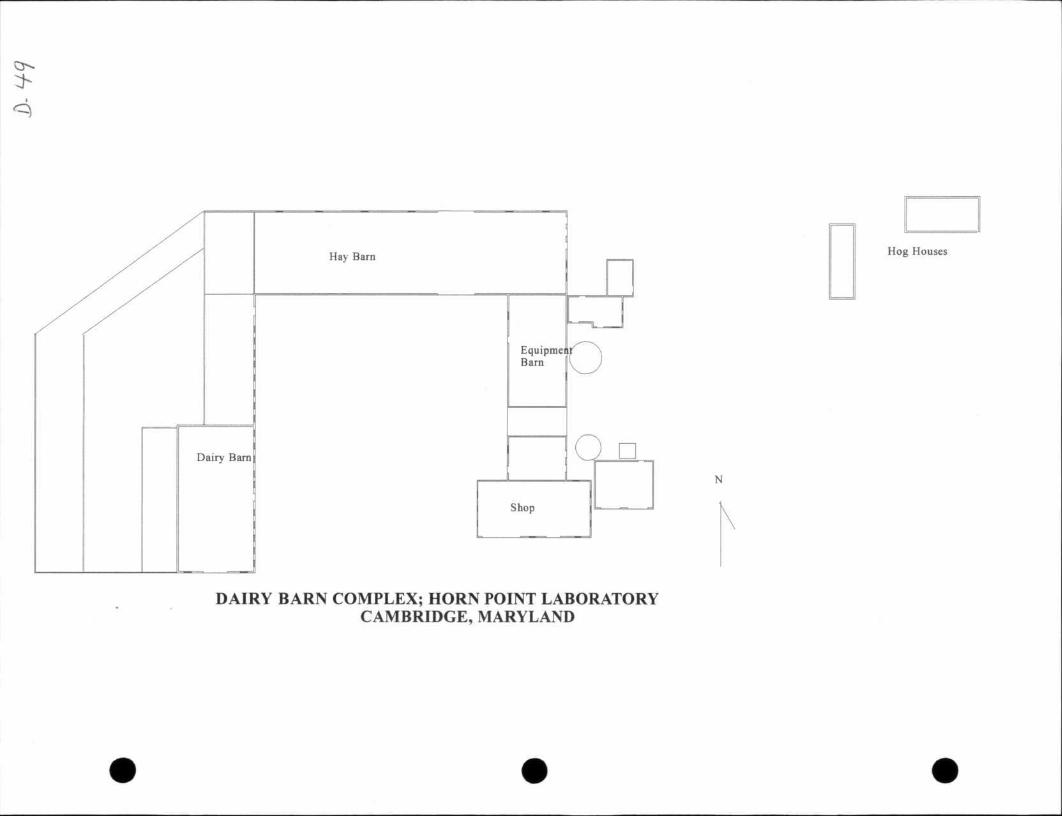
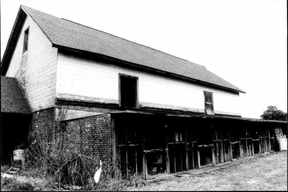
The bam complex consists of three principal sections. The first is a late nineteenth-century, brick and frame dairy bam. The remainder of the complex was constracted in the twentieth century. The second principal section is a frame hay bam, and the third is a frame equipment bam. Also associated with the bam complex is a two-story, frame shop, concrete silo, ice house, cold-storage house, two grain dryers, two hog houses, and a series of open sheds.
The Dairy Bam Complex at Horn Point is a product of the T. Coleman duPont era of ownership of this property which has been occupied by European Americans since the middle of the seventeenth century. At the present time, the property is the campus of the Horn point Laboratory of the University of Maryland. The laboratory has been using this property since 1976 for research and education and has constracted additional, modem buildings on the property. In addition, they have removed several of the older buildings on the campus. Because the setting of the property has changed and the dairy bam complex exists in isolation and separate from its original agricultural and recreational purposes, the dairy bam complex has lost its integrity of setting and relationship with the historic use of the property. Accordingly, the dairy bam complex is not eligible for listing in the NRHP.
Considerations: A B C D E F G
MARYLAND HISTORICAL TRUST REVIEW
Eligibility recommended Eligibility not recommended x
Criteria: A B C D
MHT Comments:
Tania Georgiou Tully
Reviewer Office of Preservation Services
Monday, January 07, 2002
Date
Reviewer, National Register Program Date

Maryland Historical Trust Maryland Inventory of Historic Properties Form
D-49
DEC 0 7 Z001
—
1. Name of Property (indicate preferred name)
historic Horn Point
other du Pont Dairy Barn
2. Location i - ' O . U , .
street and number 2020 Horn Point Road not for publication
city, town Cambridge X_ vicinity
county Dorchester
3. Owner of Property (give names and mailing addresses of all owners)
name Maryland Board of Public Works
street and number telephone 410-228-8400
city, town Annapolis state Maryland zip code 21400
4. Location of Legal Description courthouse, registry of deeds, etc. Dorchester County Courthouse liber 170 folio 62
city, town Cambridge, MD tax map 29 tax parcer <J tax ID number 174969
5. Primary Location of Additional Data Contributing Resource in National Register District Contributing Resource in Local Historic District Determined Eligible for the National Register/Maryland Register Determined Ineligible for the National Register/Maryland Register Recorded by HABS/HAER Historic Structure Report or Research Report at MHT
X Other: Dorchester County Public Library
6. Classification
Category district
X buildinq(s) structure site object
Ownership X public
private both
Current Function agriculture commerce/trade defense domestic education funerary government health care industry
.landscape jecreation/culture _religion _social Jransportation _work in progress _unknown _vacant/not in use other:
Resource Count Contributing Noncontributing
(l
o
buildings sites structures
. objects Total
Number of Contributing Resources previously listed in the Inventory
0

Maryland Historical Trust Maryland Inventory of M
Historic Properties Form
Name Continuation Sheet
Number _7_ Page 2
7. Description Inventory No D-49
Condition
excellent _X_ deteriorated good ruins
_ fair _ altered
Prepare both a one paragraph summary and a comprehensive description of the resource and its various elements as it exists today.
The barn complex consists of three principal sections. The first is a late nineteenth-century, brick and frame dairy barn. The remainder of the complex was constructed in the twentieth century. The second principal section is a frame hay barn and the third is a frame equipment barn. Also associated with the barn complex is a two-story, frame shop, concrete silo, ice house, cold-storage house, two grain dryers, two hog houses, and a series of open sheds.
There are no historical records available at the Laboratory or within the local records of Dorchester County that provide exact or approximate dates of construction for the barn complex. The property was acquired by T. Coleman duPont of Delaware, Maryland, and New York City in 1912 for use as a hunting lodge. Mr. duPont used the property as a hunting lodge until his death in 1930. The property remained in the family until 1956 when it was sold to the City of Cambridge for $5.00. The City owned the property until 1971 when it was sold for $10.00 to the Maryland Board of Public Works for use by the University of Maryland as an environmental educational facility; its current use and owner. Prior to Mr. duPont's ownership, the land was farm land which was owned local prominent families as a farm and country property.
It does appear that the two-story, brick and frame dairy barn was constructed first. There is the potential that this portion of the barn complex predates the purchase of the property by Mr.
Inventory No. D-49

Maryland Historical Trust Maryland Inventory of M
Historic Properties Form
Name Continuation Sheet
Number _7_ Page 3
duPont in 1912. The construction of the barn is consistent with other dairy barns in the mid Eastern Shore at the end of the nineteenth century. Also, the barn is similar to national designs advertised in agricultural plan books at the end of the nineteenth century.
The first floor is brick that is laid in five-course common bond with a soft, lime-based mortar between the rough-fired bricks. The lower level has a poured concrete floor. The frame upper level has its principal timbers joined with mortise and tenon joints. Secondary timber is joined with wire nails. The roof is framed using a modified queen-post rafter system. The upper floor is sided with asbestos shingles nailed over vertical-board siding. There is no interior finish on the upper level. The bricks appear to have been whitewashed or painted on the exterior as some examples of that coating remain. The interior brick surface is painted white. Access to the first level is by a set of double-leaf, wood doors set into the gable ends. The double-leaf doors are flanked by single-leaf doors. The double doors would have been used by cows and other animals to enter the barn. The single-leaf doors would have been used by dairy and farm staff when the larger doors were closed. The side windows of the first floor are six-light, single-sash windows with hinges on the lower rail to allow them to swing in from the top.
The first floor of this building was used as a milking station. Metal stanchions for five cows remain along the east side of the building. In the early 1950s, there was a second row of stanchions on the west side of the barn (Laskowski 1955: 131).
There are wooden stairs on the west side of the interior which lead into the upper level. The upper level is open to the roof. There is a single-leaf door at the front or south gable end at this level. There are also two windows on the front and one central window at the rear. The side elevations have two windows each. The upper level windows are 6 over 6, double-hung sash in wood frames. The upper level would have been used for hay or feed storage. Access to this level for large loads would have been through the double-leaf, sliding doors set into the upper section of the south gable end. A built-in metal conveyor system with a block-and-tackle slider would have been used to set the loads of feed.
I nventory No. D-49

Attached to the rear north end of the dairy barn is a gable-roofed, open shed with its rear or east wall being constructed of brick laid in five-course common bond. The window opens are similar to those of the first floor of the dairy barn except that the frames are flat without the ogee molding of the dairy barn. The western edge of the roof of this shed is supported by two brick columns.
Attached to the north end of the open brick shed is an open, gable-roofed, frame shed. The rear wall of the shed is board siding. The frame shed constructed in two sections with the first set at an angle from the open brick shed and the second laid parallel to the dairy barn and extending back 98 feet to meet the rear section.
There is an additional open shed attached to the west side of the dairy barn. This shed has a brick end wall at its north end. These open sheds were intended for equipment storage. Except for the brick shed, the sheds were constructed in the middle of the twentieth century. The brick shed and the side shed might have been constructed in the 1920s or the 1930s and near to the time when the large hay barn and the equipment barn were added to the complex.
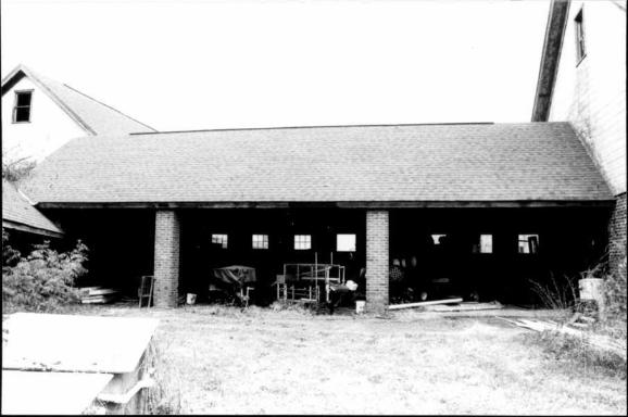
The largest section of the barn complex is the frame, two-story, hay barn. This barn has a poured concrete foundation. The edges of the foundation show the marks left by the narrow board forms used to contain the concrete when it was poured. The reinforcement material is not exposed but it was likely to be wire mesh or a wire fence-like material. The front or south side of the barn is open at the first level. The exterior covering of the hay barn is vertical board siding under asbestos shingle. Access for hay and other loads is through a pass-through door that is two-stories high and extended from the south side to the north side. At the present time, the south-side doors only include the upper level half although the metal hinges are still set in the door frame.
The second level is enclosed except for the windows and the two-story door at the front and rear of this barn. The south side of the barn is supported by cast iron round columns. Wood beams or plate are laid on top of these cast iron columns and cast iron I-beams are run from north to south as intermediate floor supports. There is a central cast iron I-beam that runs down the center of the second floor as a support for the wood floor joists of that upper floor. The upper floor covering is wood planks laid on the wood floor joists.
The third principal section of the barn complex is the equipment barn. This barn is attached to the south and east side of the hay barn and extends perpendicular to that barn and parallel to the dairy barn. The sides of the three barns form an interior courtyard.
The equipment barn is the most recent of the principal sections. It is constructed of sawn timbers which are bolted together with machine-made bolts, washers, and fasteners. All visible nails are wire. It is likely that this barn was erected in the 1930s. The equipment barn sits on a poured concrete foundation and has a poured concrete floor. The most likely reinforcing material for this floor is wire mesh. The foundation shows the edge marks for the narrow wood boards used to create the concrete forms. The building is sided in vertical wood planks which have been covered with asbestos siding.
Equipment would have entered the barn through the pass-through doors on the east and west sides. These doors are aligned to allow for straight passage. There is a grate in the concrete floor that extends from door to door which would have permitted equipment to be washed and allow for the water to be carried away. This might also have served as a water or waste gutter if animals were housed in this barn. The interior of the first floor has been retrofitted for laboratory space that is now devoted to storage. The conversion of this space to other uses involved the removal or the covering of the original walls and floor and it is difficult to determine the original
D-49

Maryland Historical Trust Maryland Inventory of Inventory No.
Historic Properties Form D-49
Name Continuation Sheet
Number _7_ Page 1
or historic uses for this barn before the Laboratory occupied the space. The doors extend for a full two stories and slide open on a cast iron guide affixed to the outside of the barn. The southwest side of the equipment barn is dominated by the large, two-story, poured concrete silo. The silo is capped by a wood gable roof. Access to the contents of the silo would have been from inside the equipment barn. This design feature might indicate that this barn was originally intended for cattle.
There is a two-story, frame shop attached to the south end of the equipment barn. The upper level of this building may have been used as a quarters for one of the estate workers. The exterior siding is asbestos shingles over wood weatherboard. The interior of the lower level is covered with vertical board, tongue and groove boards. There is a garage entrance on the south side that may not be original and the current entrance to the shop has been altered from its original configuration as a door and window combination. The windows are boarded over but were originally 6 over 6, double-hung sash. Next to the shop and set back from the front on the east side is a one-story frame garage.
Behind the shop and arranged along the east side of the equipment barn are support structures for the dairy operations at the property. They include a small, single, story icehouse, two round, iron grain dryers, and a milkhouse. The milkhouse or cold-storage house is attached to the equipment barn but there does not appear to have been any access from the milkhouse to the equipment barn. Like the two frame barns, the icehouse and the milkhouse are covered with asbestos shingle siding.
Across the street and east of the the barn complex, there are two single-story masonry hog houses. These buildings are now used for laboratory and equipment storage.

8. Significance Inventory No. D-49
Period
_ 1600-1699 _ 1700-1799 _ 1800-1899 _ 1900-1999
X 2000-
Specific dates
Areas of Significance
X agriculture _ archeology _ architecture _a r t
commerce _ communications _ community planning
conservation
1900-1940
Construction dates 1900-1940
Evaluation for:
X National Register
Check and justify below
_ economics _ education _ engineering _ entertainment/
recreation _ ethnic heritage _ exploration/
settlement
X
_ health/medicine _ industry _ invention _ landscape architecture
law _ literature _ maritime history
military
Architect/Builder
Maryland Register
_ performing arts _ philosophy _ politics/government _ religion
science _ social history _ transportation
_ other:
unknown
not evaluated
Prepare a one-paragraph summary statement of significance addressing applicable criteria, followed by a narrative discussion of the history of the resource and its context. (For compliance projects, complete evaluation on a DOE Form - see manual.)
The Dairy Barn Complex at Horn Point is a product of the T. Coleman duPont era of ownership of this property which has been occupied by European Americans since the middle of the seventeenth century. At the present time, the property is the campus of the Horn Point Laboratory of the University of Maryland. The Laboratory has been using this property since 1976 for research and education and has constructed additional, modem buildings on the property. In addition, they have removed several of the older buildings on the campus. Because the setting of the property has changed and the dairy bam complex exists in isolation and separate from its original agricultural and recreational purposes, the dairy barn complex has lost its integrity of setting and relationship with the historic use of the property. Accordingly, the dairy barn complex is not eligible for listing on the National Register of Historic Places.
The property at 2020 Horn Point Road has been known as Horn Point since the middle of the seventeenth century. The property was first laid out as the land of John Home who arrived in 1659 as an associate of Anthony LeCompte. The land sits on LeCompte Bay of the Choptank River and Home Point or Horns Point has been a prominent feature on navigation charts of the Choptank River since the seventeenth century. Based on historical research and some archeological investigations, it would appear that John Home or his agents built a dwelling on the property and used the property for agricultural purposes during the seventeenth and eighteenth centuries. The research and artifacts are housed at the Dorchester Heritage Museum which is located in the airplane hanger that was constructed during the duPont ownership of the property.
By the early nineteenth century, Horn Point had become the property of Charles Goldsborough. The Goldsborough family was prominent in both Dorchester County and in Talbot County. Maryland Governor Charles Goldsborough (1818) owned this property as a farm and investment property where his principal residence was Shoal Creek near Cambridge and the Goldsborough House in Cambridge. Governor Goldsborough's son, William T., did live at Horn Point (Laskowski 1955: 131). By 1877, the Horn Point was owned by James Steele. The Steele family was a locally significant family with connections to the Golds borough family and other political and social elite families in Maryland. There are several James Steele's listed in Jones' New Revised History of Dorchester County and it is not clear which owned or occupied this property.

Maryland Historical Trust Maryland Inventory of inventory NO D-49 Historic Properties Form
Name Continuation Sheet
Number _8_ Page 1
In 1912, Horn Point was purchased by T. Coleman duPont. His first purchase was 303 acres which included the land on which the barn sits and the principal residence which was listed as the home of James M. Steel although the property was purchased by Mr. duPont from John R. and Lilian S. Patterson (Dorchester County Deed Book WLR4, folio 649). Over the next thirteen years, Mr. duPont would purchase five additional parcels of land to assemble the final parcel of more than 800 acres. Mr. duPont used this property as a hunting lodge. He maintained several other residences including property in New York City, Florida, and Wilmington, Delaware.
At the time of his purchase of Horn Point, Mr. duPont was chairman of the E.I. duPont de Nemours and Company. Along with his cousins, Pierre Samuel duPont and Alfred I. duPont, he had purchased the duPont Company from the previous generation of duPonts and had developed the company into the largest gunpowder manufacturer in the Country. The purchase of the company had taken place in 1902. Soon the three cousins went on a buying spree and purchased most of the gunpowder companies in America and acquired several foreign firms as well. Their efforts at establishing the powder company soon attracted the attention of the federal government who filed suit against the company for violating antitrust laws. The suit was filed in 1907 and settled in June of 1912 (Carr 1964:244). The month after the suit was settled, T. Coleman duPont bought the Horn Point property.
Mr. duPont had been ill since about 1908 and had taken numerous leaves of absence from his duties at the duPont Company. He also began to develop other interests including real estate, hotels, and politics. In 1911, he announced that he would build a modern highway through the State of Delaware. He began this effort in 1912 and financed most of the road with his personnel funds. This highway is now labeled as U.S. Route 13 or the duPont Highway in honor of his effort. In 1912, duPont also began to purchase real estate in New York City and began the construction of the McAlpin Hotel and the next year began construction of the Equitable Building. At forty stories, this was the tallest building in New York. Although, Mr. duPont spent most of his time in New York City, he remained a legal resident of Delaware and head of the Republican Party in that state. As his real estate and other interests grew at this time, Mr. duPont decided to withdraw from control of the duPont Company and, in 1915, sold his stock to a group of family members lead by Pierre Samuel duPont (Carr 1964:270).
«
With his increased capital from the sale of his company stock, Mr. duPont turned his attention to politics. For a short while, there was an effort to encourage him to run for President of the United States but that soon died out. In 1921, he was appointed to complete the term of office for a Delaware Senator who had resigned to allow Mr. duPont to become a Senator. He served for one year and lost his effort to win election for the position. He ran again in 1925 and won the position. He resigned in 1928 for health reasons. Mr. duPont died in 1930. His property was inherited by his son Francis I. duPont. For legal reasons, the Horn Point property was eventually transferred to corporations controlled by T. Coleman duPont's family until the property was sold to the City of Cambridge in 1956. The City sold the property to the State of Maryland in 1976 for use by the University of

Maryland Historical Trust Maryland Inventory of Historic Properties Form
Name Continuation Sheet
Number _8_ Page 2
Maryland for its School of Marine Studies. At the same time that the Horn Point property was donated to the City of Cambridge, the duPont family also gave the City a new office building being constructed on High Street. This was later sold to a local bank. The City was also given a special fund to purchase fireworks for the annual 4th of July celebrations. This fund continues to pay for a sizable amount of fireworks on the 4th.
Horn Point was a recreational property for T. Coleman duPont. Like many of the members of his family, he liked the outdoors and liked to hunt and to fish. There were and are numerous duPont family hunting properties spread across the country. When they would establish such a recreational property, they would often encourage other members of their circle to join them. One who followed T. Coleman duPont to Dorchester County was the famous sharpshooter and performer Annie Oakley. She bought a small property at the edge of Cambridge on the Choptank River and would often hunt at Horn Point and join Mr. duPont and his guests for hunting and demonstrations. The duPont Powder Company sponsored Annie Oakley and provided her with the special gunpowders that she used in her shows and demonstrations.
Many of the duPont members were also interested in agriculture; principally in cattle and in sheep. The family is credited with introducing merino sheep into this country in the early nineteenth century. Horn Point, like a number of duPont properties, commemorates this tradition with sheep statues and ornaments. Horn Point retains the entrance pillars at the main road to the campus which consist of tall brick posts with a male sheep carved in stone on top of each. Many of the principal and secondary rural properties owned by the duPont family include cattle barns.
In that regard, Horn Point is part of that same pattern of duPont development of their country properties. When Mr. duPont purchased Horn Point, the house had burned in 1903 and he constructed a new dwelling. This building burned about 1948 and was replaced by the current building in 1950. This building has been converted in the administration building for the campus.
Based upon a physical examination of the barn complex, it is likely that the brick dairy barn predates Mr. duPont's purchase of the property. Dorchester County does not have a strong tradition as a cattle and dairy region but cattle and dairy production was a popular activity for county farmers at the end of the nineteenth century. Most of the dairy products were consumed locally and with Cambridge being the largest city on the Eastern Shore, there was a demand for dairy products with the cannery workers and city dwellers. There are less than two dozen nineteenth or twentieth century dairy barns remaining in Dorchester County at the present time. Those that do remain are generally not used but they do have the same form and use of materials as the dairy barn at Horn Point. In general, they have a masonry first floor and a frame second floor. The second floor was used for feed storage and the first floor was used for milking and processing.
Local records and tradition do not indicate when the hay barn and the equipment barn, the other pieces of the barn complex, were constructed. One source reports that Mr. duPont keep a large cattle herd at Horn Point and
Inventory No. D-49
Maryland Historical Trust Maryland Inventory of inventory NO D-49 Historic Properties Form
Name Continuation Sheet
Number _8_ Page 3
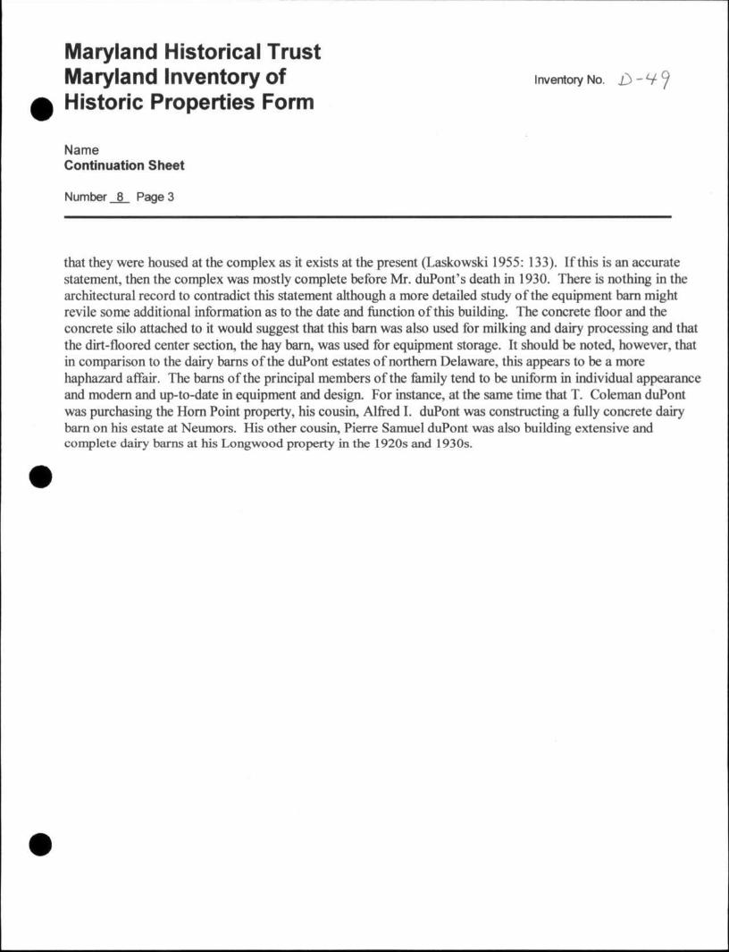
that they were housed at the complex as it exists at the present (Laskowski 1955: 133). If this is an accurate statement, then the complex was mostly complete before Mr. duPont's death in 1930. There is nothing in the architectural record to contradict this statement although a more detailed study of the equipment barn might revile some additional information as to the date and function of this building. The concrete floor and the concrete silo attached to it would suggest that this barn was also used for milking and dairy processing and that the dirt-floored center section, the hay barn, was used for equipment storage. It should be noted, however, that in comparison to the dairy barns of the duPont estates of northern Delaware, this appears to be a more haphazard affair. The barns of the principal members of the family tend to be uniform in individual appearance and modern and up-to-date in equipment and design. For instance, at the same time that T. Coleman duPont was purchasing the Horn Point property, his cousin, Alfred I. duPont was constructing a fully concrete dairy barn on his estate at Neumors. His other cousin, Pierre Samuel duPont was also building extensive and complete dairy barns at his Longwood property in the 1920s and 1930s.

9. Major Bibliographical References
See Attached Inventory Sheet
10. Geographical Data
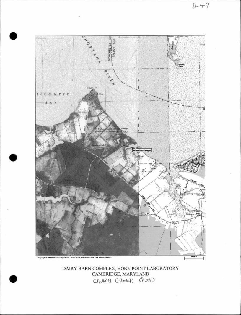
Acreage of surveyed property 2 Acreage of historical setting 846.86 Quadrangle name Cambridge Quadrangle scale: 1:24500
Verbal boundary description and justification The Boundary for this property and the Area of Potential Effect for this undertaking are the limits of the Dairy Barn Complex on DuPont Road at the Horn Point Laboratory in Cambridge, MD. No additional area is included as this project will have no impact on other resources and there are no above ground historic properties in the area.
The property is located at UTM coordinates 18/0401500/4271610.
11. Form Prepared by
name/title
organization
street & number
city or town
Stephen G. Del Sordo/Historian, Architectural Historian
Heritage Resource Group, Inc. date
P.O. Box 332 telephone
Cambridge state
November 2001
410-228-8934
MD21613
The Maryland Inventory of Historic Properties was officially created by an Act of the Maryland Legislature to be found in the Annotated Code of Maryland, Article 41, Section 181 KA, 1974 supplement.
The survey and inventory are being prepared for information and record purposes only and do not constitute any infringement of individual property rights.
Maryland Historical Trust DHCD/DHCP 100 Community Place Crownsville, MD 21032-2023 410-514-7600
Inventory No. D-49
return to:

Maryland Historical Trust Maryland Inventory of Historic Properties Form
Name Continuation Sheet
Number _9_ Page 1
Bibliography
Carr, William H. A. 1964 The duPonts of Delaware. Dodd, Mead & Company, New York.
Colby, Gerard 1984 Du Pont Dynasty. L. Stuart, Secaucus, NJ.
Dorian, Max 1961 The du Ponts; From Gunpowder to Nylon. Little, Brown and Company. Boston.
Duke, Marc 1976 The du Ponts; Portrait of a Dynasty. Saturday Review Press. New York.
Gates, John D. 1979 The du Pont Family. Doubleday. Garden City, NY.
Graham, John L., ed 1976 The 1877 Atlases and Other Early Maps of the Eastern Shore of Maryland. Wicomico Bicentennial
Commission. Salisbury, MD.
Jones, Elias 1966 New Revised History of Dorchester County, Maryland. Tidewater Publishers. Cambridge, MD.
Laskowski, F. Arthur, 1955 The Laskowski Papers, typscript manuscript, The Maryland Room, Dorchester County Public Library.
Mosley, Leonard 1980 Blood relations: The Rise & Fall of the du Ponts of Delaware. Atheneum, New York.
Weeks, Christopher, ed 1-984 Between the Nanticoke and the Choptank; An Architectural History of Dorchester County, Maryland. The Johns Hopkins University Press, Baltimore.
Inventory No. D-49
D-4
9
DAIRY BARN COMPLEX; HORN POINT LABORATORY CAMBRIDGE, MARYLAND

D-49

D-49
D-49
DAIRY BARN COMPLEX; HORN POINT LABORATORY CAMBRIDGE, MARYLAND
CHURCH CREEK QUAD


D-49
MARYLAND HISTORICAL TRUST WORKSHEET
NOMINATION FORM for the
NATIONAL REGISTER OF HISTORIC PLACES, NATIONAL PARKS SERVICE
!.: NAME
Horn Po in t A N D / O R H I S T O R I C :
2. LOCATION
S T R E E T AND NUMBER:
Horn Po in t Road. 1.5 mile N.W. of Rt . 343 CITY OR TOWN:
Cambridge S T A T E
Maryland. C O U N T Y :
Dorches te r 3. CLASSIF ICAT ION
CATEGORY (Check One)
• District Q Building
Kl S>t» • Structure
• Object
OWNERSHIP
SO Public
• Private
• Both
Public Acquisition:
• In Process
(~| Being Considered
STATUS
53 Occupied
• Unoccupied
• Preservation work in progress
ACCESSIBLE
TO THE PUBLIC
Yes: Eg Restricted
• Unrestricted
• No
PRESENT USE (Check One or More as Appropriate;
K) Agricultural
I I Commercial
[ I Educational
• Entertainment
J Government
I I Industrial
• Military
[~l Museum
• Pork
• Private Residence
I I Religious
I I Scientific
I I Transportation d Comments
• Other rspeciryj
[4. OWNER O F P R O P E R T Y " O W N E R ' S N A M E :
S t a t e of Maryland, Board of Publ ic Works S T R E E T AND NUMBER:
300 W. Pres ton S t r e e t C I T Y OR TOWN:
Balt imore L O C A T I O N OF L E G A L DESCRIPTION
Maryland 21201
C O U R T H O U S E . REGISTRY O F DEEDS. E T C :
Dorches te r County Courthouse S T R E E T AND N U M B E R :
High S t r e e t C I T Y OR TOWN:
Annapolis Maryland T i t l e Reference of Current Deed (Book & Pg. # ) : 175/652
REPRESENTATION IN EXISTING SURVEYS
21401
TITLE OF SURVEY:
DATE OF SURVEY: Q Federal • State Q County • Local DEPOSITORY FOR SURVEY RECORDS:
STREET AND NUMBER:
CITY OR TOWN: (STATE: I

D-49
7. DESCRIPTION
CONDITION
(Check One)
n Exc.lUnt S3 GooJ D Fo'r D D.t.riorof.d • Ruins • Un.xpoi.d
(Check One)
g j Altered D Unclt.r.d
CCnack O m ;
D Moved g ] Original Sire D E S C R I B E T H E P R E S E N T * ^ D O R I G I N A L (11 known) P H Y S I C A L A P P E A R A N C E
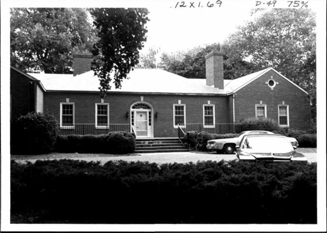
The present house a t Horn's Point was constructed a f t e r the o r ig ina l house burned in 1948.
D-49 SIGNIFICANCE
S T A T E M E N T O F S I G N I F I C A N C E
SE
E
IN
ST
S
Pj
C
T I
0
N S
PERIOD ("Check One or More • • Appropriate.)
• Pre-Columbion • 16th Century
• 15th Century D '7th Century
• 18th Century
IS 19th Century
Kl 20th Century
SPECIFIC DATEISI (If Applicable mnd Known)
AREAS OF SIGNIFICANCE (Check One or More •« Appropriate)
Abor iginol
I I Prehistoric
• Historic
[ | Agriculture
I I Architecture
• Aft
[~l Commerce
~] Communications
I I Conservation
n Education
0 Engineering
(S3 Industry
Ql Invention
1 I Landscape
Architecture
• Literature
D Military
• Music
E3 Political
• Religion/Phi.
losophy
Ql Science
I 1 Sculpture
I I Sociol/Humon-
itarian
• Theater
1 I Transportation
1 I Urban Planning
• Oth.r (Specify)
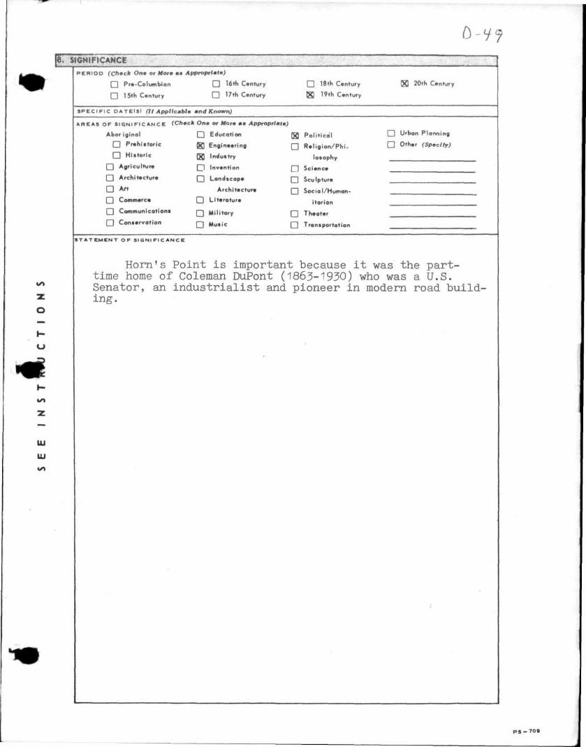
Horn's Point i s important because i t was the p a r t -time home of Coleman DuPont (1863-1930) who was a U.S. Senator, an i n d u s t r i a l i s t and pioneer in modern road bui lding.
PS-709

D-49
MAJOR BIBLIOGRAPHICAL REFERENCES
Maryland, A Guide to the Old Line S ta te , Oxford University Press , New York, p . 403.
ftO- GEOGRAPHICAL DATA L A T I T U D E AND L O N G I T U D E C O O R D I N A T E S
D E F I N I N G A R E C T A N G L E L O C A T I N G T H E P R O P E R T Y
NW
N E
SE
sw
L A T I T U D E
Degrees Minutes Seconds
L O N G I T U D E
Degrees Minutes Seconds
L A T I T U D E A N D L O N G I T U D E C O O R D I N A T E S D E F I N I N G T H E C E N T E R P O I N T O F A P R O P E R T Y
O F LESS T H A N T E N ACRES
L A T I T U D E
Degrees Minutes Seconds O i •
L O N G I T U D E
Degrees Minutes Seconds
APPROXIMATE ACREAGE OF NOMINATED PROPERTY: SE
E
IN
ST
RU
CT
IO
NS
Acreage Justification:
819. 38 acres Tax Map 29, p. 9
11. FORM PREPARED BY N A M E AND T I T L E :
Michael Bourne, Architectural Consultant ORG ANI Z A T I O N
Maryland Historical Turst July, 1975 STREET AND NUMBER:
Shaw House, 21 State Circle CITY OR TOWN:
Annapolis Maryland 21401 12. ^State Liaison Officer Review; (Office Use Only)
Significance of this property is National • State • Local •
Signature