Maryland Challenge, Frederick MD - HikingUpward · 2014-07-11 · Maryland Challenge, Frederick MD...
5
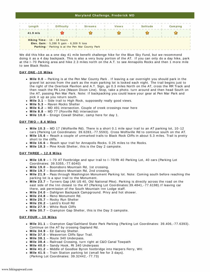
www.hikingupward.com Maryland Challenge, Frederick MD Length Difficulty Streams Views Solitude Camping 41.9 mls Hiking Time: Elev. Gain: Parking: 16 - 18 hours 5,288 ft gain - 6,309 ft loss Parking is at the Pen Mar County Park We did this hike as a one day 41 mile benefit challenge hike for the Blue Sky Fund, but we recommend doing it as a 4 day backpack. This is also a very busy portion of the AT. If you can only do a day hike, park at the I-70 Parking area and hike 2.3 miles north on the A.T. to see Annapolis Rocks and then 1 more mile to see Black Rocks. DAY ONE -10 Miles Mile 0.0 – Parking is at the Pen Mar County Park . If leaving a car overnight you should park in the gravel lot across from the park as the main parking lot is locked each night. The trail begins just to the right of the Overlook Pavilion and A.T. Sign, go 0.3 miles North on the AT, cross the RR Track and then reach the PA Line (Mason Dixon Line). Stop, take a photo. turn around and then head South on the AT, passing Pen Mar Park. Note: If backpacking you could leave your gear at Pen Mar Park and pick it up as you return south. Mile 3.1 – Side trail to High Rock, supposedly really good views. Mile 5.3 – Raven Rocks Shelter Mile 6.2 – MD 491 intersection. Couple of creek crossings near here Mile 8.8 – MD 77 (Foxville Rd) intersection Mile 10.0 – Ensign Cowall Shelter, camp here for day 1. DAY TWO – 8.4 Miles Mile 10.3 – MD 17 (Wolfsville Rd). There is a short 0.1 mile spur trail to an AT parking lot, 10-12 cars (Parking Lot Coordinates: 39.6283,-77.5593). Cross Wolfsville Rd to continue south on the AT. Mile 15.6 – Reach a couple of unmarked trails to Black Rock Cliffs in about 5.3 miles. Trail is pretty short to the cliffs. Mile 16.6 – Reach spur trail for Annapolis Rocks. 0.25 miles to the Rocks. Mile 18.3 – Pine Knob Shelter, this is the Day 2 campsite. DAY THREE – 12.8 Miles Mile 18.9 – I-70 AT Footbridge and spur trail to I-70/Rt 40 Parking Lot, 40 cars (Parking Lot Coordinates: 39.5355,-77.6040) Mile 19.0 – Boonsboro Mountain Rd, 1st crossing. Mile 19.7 – Boonsboro Mountain Rd, 2nd crossing. Mile 21.9 – Pass through Washington Monument Parking lot. Note: Coming south before reaching the parking lot is a spur trail to the Monument. Mile 23.7 – Turners Gap (Alt US 40, Old National Pike). Parking is directly across the road on the east side of the Inn closest to the AT (Parking Lot Coordinates:39.4841,-77.6198).If leaving car there, ask permission of the South Mountain Inn Lodge staff. Mile 24.0 – Dahlgren Backpack Campground. Privy and hot shower. Mile 24.8 – Reno Monument Rd. Mile 25.7 – Rocky Run Shelter Mile 26.2 – Lamb's Knoll Rd Mile 27.9 – White Rock Cliffs Mile 30.7 – Crampton Gap Shelter, this is the Day 3 campsite. DAY FOUR – 10 Miles Mile 31.1 – Crampton Gap/Gathland State Park Parking (Parking Lot Coordinates: 39.406,-77.6393). Continue on the AT by crossing Gapland Rd. Mile 34.9 – Ed Garvey Shelter. Mile 37.0 – Weaverton Cliffs Spur Trail. Mile 38.1 – Route 340 Underpass. Mile 38.4 – Railroad Crossing, turn right at C&O Canal Towpath Mile 40.0 – Sandy Hook, Rt 340 Underpass Mile 41.2 – Middle of Goodloe Byron footbridge into Harpers Ferry, WV. Mile 41.5 – Train Station parking lot (small fee for 3 days). (Parking Lot Coordinates: 39.32442,-77.73)
Transcript of Maryland Challenge, Frederick MD - HikingUpward · 2014-07-11 · Maryland Challenge, Frederick MD...
www.hikingupward.com
Maryland Challenge, Frederick MD
Length Difficulty Streams Views Solitude Camping
41.9 mls
Hiking Time:Elev. Gain:
Parking:
16 - 18 hours5,288 ft gain - 6,309 ft lossParking is at the Pen Mar County Park
We did this hike as a one day 41 mile benefit challenge hike for the Blue Sky Fund, but we recommenddoing it as a 4 day backpack. This is also a very busy portion of the AT. If you can only do a day hike, parkat the I-70 Parking area and hike 2.3 miles north on the A.T. to see Annapolis Rocks and then 1 more mileto see Black Rocks.
DAY ONE -10 Miles
Mile 0.0 – Parking is at the Pen Mar County Park . If leaving a car overnight you should park in thegravel lot across from the park as the main parking lot is locked each night. The trail begins just tothe right of the Overlook Pavilion and A.T. Sign, go 0.3 miles North on the AT, cross the RR Track andthen reach the PA Line (Mason Dixon Line). Stop, take a photo. turn around and then head South onthe AT, passing Pen Mar Park. Note: If backpacking you could leave your gear at Pen Mar Park andpick it up as you return south.Mile 3.1 – Side trail to High Rock, supposedly really good views.Mile 5.3 – Raven Rocks ShelterMile 6.2 – MD 491 intersection. Couple of creek crossings near hereMile 8.8 – MD 77 (Foxville Rd) intersectionMile 10.0 – Ensign Cowall Shelter, camp here for day 1.
DAY TWO – 8.4 Miles
Mile 10.3 – MD 17 (Wolfsville Rd). There is a short 0.1 mile spur trail to an AT parking lot, 10-12cars (Parking Lot Coordinates: 39.6283,-77.5593). Cross Wolfsville Rd to continue south on the AT.Mile 15.6 – Reach a couple of unmarked trails to Black Rock Cliffs in about 5.3 miles. Trail is prettyshort to the cliffs.Mile 16.6 – Reach spur trail for Annapolis Rocks. 0.25 miles to the Rocks.Mile 18.3 – Pine Knob Shelter, this is the Day 2 campsite.
DAY THREE – 12.8 Miles
Mile 18.9 – I-70 AT Footbridge and spur trail to I-70/Rt 40 Parking Lot, 40 cars (Parking LotCoordinates: 39.5355,-77.6040)Mile 19.0 – Boonsboro Mountain Rd, 1st crossing.Mile 19.7 – Boonsboro Mountain Rd, 2nd crossing.Mile 21.9 – Pass through Washington Monument Parking lot. Note: Coming south before reaching theparking lot is a spur trail to the Monument.Mile 23.7 – Turners Gap (Alt US 40, Old National Pike). Parking is directly across the road on theeast side of the Inn closest to the AT (Parking Lot Coordinates:39.4841,-77.6198).If leaving carthere, ask permission of the South Mountain Inn Lodge staff.Mile 24.0 – Dahlgren Backpack Campground. Privy and hot shower. Mile 24.8 – Reno Monument Rd.Mile 25.7 – Rocky Run ShelterMile 26.2 – Lamb's Knoll RdMile 27.9 – White Rock CliffsMile 30.7 – Crampton Gap Shelter, this is the Day 3 campsite.
DAY FOUR – 10 Miles
Mile 31.1 – Crampton Gap/Gathland State Park Parking (Parking Lot Coordinates: 39.406,-77.6393).Continue on the AT by crossing Gapland Rd.Mile 34.9 – Ed Garvey Shelter.Mile 37.0 – Weaverton Cliffs Spur Trail.Mile 38.1 – Route 340 Underpass.Mile 38.4 – Railroad Crossing, turn right at C&O Canal TowpathMile 40.0 – Sandy Hook, Rt 340 UnderpassMile 41.2 – Middle of Goodloe Byron footbridge into Harpers Ferry, WV.Mile 41.5 – Train Station parking lot (small fee for 3 days).(Parking Lot Coordinates: 39.32442,-77.73)