
Marine Safety Investigation Report No. 205 · MARINE SAFETY INVESTIGATION ... InterDynamics’...
62
MARINE SAFETY INVESTIGATION No. 205 Independent investigation into the grounding of the passenger vessel True North in the approach passage to St. George Basin, Western Ausralia 7 August 2004
Transcript of Marine Safety Investigation Report No. 205 · MARINE SAFETY INVESTIGATION ... InterDynamics’...
MARINE SAFETY INVESTIGATION No. 205
Independent investigation into the grounding of the passenger vessel
True North
in the approach passage to St. George Basin, Western Ausralia
7 August 2004
MARINE SAFETY INVESTIGATION
No. 205
Independent investigation into thegrounding of the Australianregistered passenger vessel
True Northin the approach passage to
St. George Basin, Western Australia
7 August 2004
Released under the provisions of the Transport Safety Investigation Act 2003.

ii
ISSN 1447-087XISBN 1 877071 93 5 April 2005
This report was produced by the Australian Transport Safety Bureau (ATSB), PO Box 967, Civic Square ACT2608.
Readers are advised that the ATSB investigates for the sole purpose of enhancing safety. Consequently, reports areconfined to matters of safety significance and may be misleading if used for any other purpose.
As ATSB believes that safety information is of greatest value if it is passed on for the use of others, copyright restrictions do not apply to material printed in this report. Readers are encouraged to copy or reprint for further distribution, but should acknowledge ATSB as the source.
CONTENTS
1 SUMMARY 1
2 SOURCES OF INFORMATION 3
Acknowledgement 3
References 3
3 NARRATIVE 5True North 5
On board facilities 7
Crew 8
Life saving appliances 9
Navigational procedures 9
Cruise operations 9
Prince Regent River and St. George Basin 11
The incident 11
After the grounding 14
Temporary repairs 16
4 COMMENT AND ANALYSIS 19Evidence 19
The incident 19
The grounding 20
Echo sounder and forward scanning sonar 21
Standing orders 22
Use of tide 23
GPS positioning 23
GPS position discrepancy 25
Dedicated computers for use with ECS 27
Geodetic datum 27
Accuracy of the electronic chart 29
GPS smart antenna 29
Master’s work schedule and level of alertness 30
Safety Management System 32
Fatigue management 33
Legislation and manning requirements 33
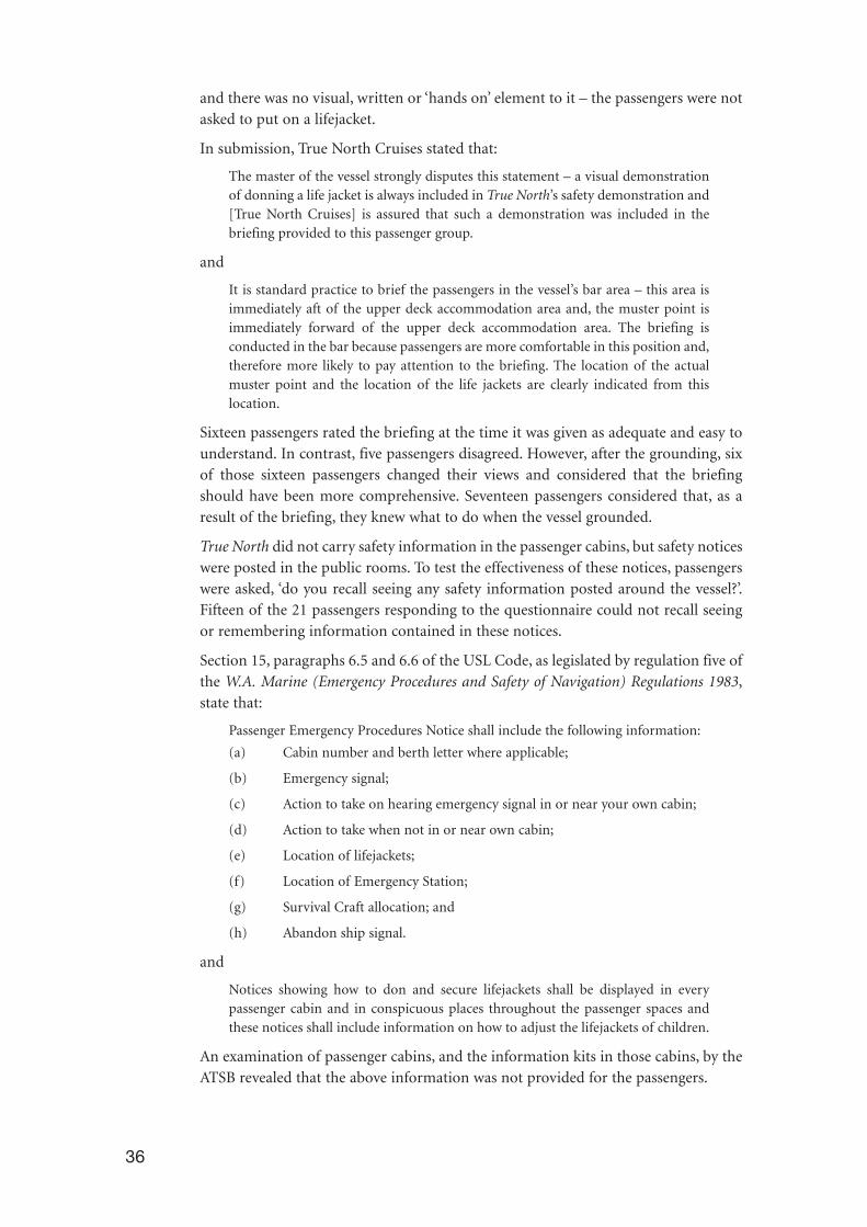
Passenger emergency procedures 35
5 CONCLUSIONS 39
6 RECOMMENDATIONS 41
7 SUBMISSIONS 43
8 TRUE NORTH 45
9 ABBREVIATIONS, TERMS AND DEFINITIONS 47
ANNEX 1 49
ANNEX 2 51
iii

iv
SUMMARY
At 2304 on 7 August 2004, the 34.56 m passenger vessel True North, with 38 peopleon board, ran aground in the entrance passage to St. George Basin in WesternAustralia’s Kimberley region. At the time of the grounding, the master was alone onthe bridge. The vessel was in automatic navigation mode with course adjustmentsinitiated by means of a GPS navigation system linked to an Electronic Chart System(ECS), that transmitted course adjustment information to an autopilot. No pollutionresulted from the grounding, although several passengers received minor injuriesduring the initial impact.
True North had draughts of 1.5 m and 2.2 m forward and aft respectively andremained aground for about one hour. It floated clear of the rock on which it hadgrounded on the incoming tide and moved under its own power to an anchoragesouth of one of the islands in St. George Basin. The vessel was beached by the masteron the morning of 8 August and a full appraisal of the damage made.
On 9 August, a repair team and equipment was flown to the vessel by float plane fromBroome, Western Australia. The passengers and non-essential crew were then flownto Broome and repair work commenced. Temporary repairs were carried out whilethe vessel was beached in between the periods of high water. These repairs werecompleted by 11 August and True North departed St. George Basin for Darwin, wherepermanent repairs were to be effected.
The vessel arrived at repair facilities in Darwin on 14 August. True North was able todepart Darwin for Wyndham on 26 August to resume its cruise schedule.
The report concludes that:
• True North grounded on or near Strong Tide Point in unsurveyed waters whilebeing navigated by an auto helm unit and ECS receiving position informationfrom GPS satellites.
• GPS derived positions plotted on the ECS differed from the vessel’s true position,possibly caused by:
- GPS system inaccuracy;
- Geodetic datum ambiguity;
- The ECS operating on a common user personal computer which allowedpossible corruption of the ECS operating system;
- A change in the GPS receiver parameters;
- Loose wiring or connections in the on board systems; or
- A combination of the above.
• Too much reliance was placed on the accuracy of GPS positions and the GPSpositions plotted on the vessel’s ECS were not adequately checked by other navigational means.
• A proper lookout was not maintained by visual, radar and other means to ensurethe vessel remained in safe water.
1
• At the time of the grounding, it is probable that the master was suffering fromsome effects of fatigue as a result of his work routine.
• There were deficiencies in the procedures which dealt with the mustering ofpassengers in that:
- The initial safety briefing was not sufficiently comprehensive;
- company orders in respect of lifejackets and emergency signals were notfollowed; and
- company practices in the provision of emergency information andprocedures did not meet WA legislative requirements.
The report recommends that:
• Owners and operators of vessels running Electronic Chart Systems should do soon dedicated computers.
• Owners, operators and masters of vessels regularly operating in confined watersshould revise procedures governing the use of GPS and auto pilot systems.
• Owners and operators of passenger vessels should ensure informationconcerning muster areas, emergency signals and instructions and diagrams ofhow to don lifejackets, are included in any passenger information kits in cabins,and on the inside of all cabin doors, in order to comply with state/territoryregulations.
• True North Cruises should review the procedures associated with passengerbriefings and the emergency information displayed in the passenger cabins andvessel common rooms.
• Owners, operators and masters of non-SOLAS vessels should consider the intro-duction of effective fatigue management policies and practices on board vessels.
• AMSA and state/territory marine authorities should carefully consider the typeof operation and area of operation when determining the safety manning ofvessels of any length.
• Western Australia’s Department of Planning and Infrastructure should considerrecommending the amendment of WA marine legislation to allow for the optionto review and, if necessary, change the safety manning requirements for stateregistered vessel.
2

2 SOURCES OF INFORMATION
The owners, management, senior master and master of True North
Australian Maritime Safety Authority
Western Australian Department of Planning and Infrastructure – Marine Safety
Passengers on board True North at the time of the grounding
AcknowledgementsElectrotech Australia, Darwin
The Australian Hydrographic Service
Dr David Silcock, School of Mathematical and Geospatial Sciences, RMIT University,Melbourne
Navigation Dynamics, Cairns
The Great Escape Charter Company, Broome
InterDynamics’ Fatigue Audit InterDyne (FAID)
ReferencesThe International Management Code for the Safe Operation of Ships and forPollution Prevention [International Safety Management (ISM) Code] as adopted bythe International Maritime Organization (IMO) by Resolution A.741(18).
International Convention on Standards of Training, Certification and Watchkeeping(STCW Convention), 1978 and 1995 amendments, and the STCW Code, theInternational Maritime Organization.
W. A. Marine (Certificates of Competency and Safety Manning) Regulations 1983.
W. A. Marine (Emergency Procedures and Safety of Navigation) Regulations 1983.
Uniform Shipping Laws (USL) Code, Australian Transport Advisory Council, asamended 1989.
National Marine Guidance Manual ‘Guidelines For Onboard Safety Training–Australian Domestic Vessels’, National Marine Safety Committee (NMSC).
AMSA Marine Notice 02/2002 (Regulatory Requirements for Vessels on Near–CoastalVoyages Subject to the Navigation Act).
Australia Pilot Volume V, seventh edition 1992.
The chart section in this publication is reproduced by permission of the AustralianHydrographic Service.
© Commonwealth of Australia 13 October 2002. All rights reserved.
Other than for the purposes of copying this publication for public use, the chartinformation from the chart sections may not be extracted, translated, or reduced toany electronic medium or machine readable form for incorporation into a derivedproduct, in whole or part, without the prior written consent of the AustralianHydrographic Service.
3

4
FIGURE 1: True North undergoing repairs in Darwin
3 NARRATIVE
True NorthTrue North is an ‘adventure cruise’ passenger vessel with an overall length of 34.56 mand a moulded breadth of 8.90 m. The vessel was built in 1999 by Image Marine inFremantle for North Star Cruises, Australia and operates out of the WesternAustralian port of Broome. True North was built under Lloyds Register of Shipping(LR) design rules as a �100A1 SSC1 mono-hull, high speed and low displacementpassenger ship. It is surveyed in accordance with section 1B of the Australian UniformShipping Laws (USL) Code2. The vessel is classed with LR and is registered with theAustralian Maritime Safety Authority (AMSA) as an Australian vessel.
True North is of welded aluminium construction and has a gross tonnage of 273. Itoperates with draughts of 1.5 m forward and 2.2 m aft. Its design features a flatbottomed hull which allows it to operate in areas of shallow water. The vessel’s tworudders and propellers are protected from damage by steel skegs which extend 1.4 mbelow the hull at the vessel’s stern. Two Naiad Marine fin stabilisers extend below thehull at the midships position. These are controlled from a panel on the wheelhouseconsole.
The vessel is powered by two independent MTU 16V 2000 M70 diesel engines, eachof 750 kW. Each engine drives a single fixed-pitch propeller, which gives the vessel anoperating speed of 12 knots. A bow thruster, mounted aft of the forward collisionbulkhead, is used to manoeuvre the vessel during berthing and unberthingoperations.
The wheelhouse is located on the upper deck, about ten metres from the stem. Arange of navigation equipment is located on the wheelhouse console. This includes aJRC JMA–3254 3 cm rasterscan radar, a JRC FVJ–130 colour echo sounder, a FurunoCH–18 forward scanning sonar colour display, a Raytheon Raystar 398 GlobalPositioning System (GPS) unit, and two personal computers (with their monitors setinto the console). Two independent Electronic Chart Systems (ECS) operate on thesecomputers, the Tsunamis 99 system being the primary ECS used. With the exceptionof the secondary ECS, this navigation equipment is mounted to port of the vessel’scentreline.
A Navicontrol AP3003 Gold autopilot unit is located to port of the wheel, on thewheelhouse centre console. A joystick tiller is located to starboard of the wheel, on thesame part of the console. Just forward of the tiller are the two main engine controls.A magnetic compass is mounted in the centre of the wheelhouse control console,directly forward of the wheel. Above the centre console are mounted the vessel’sICOM VHF radio and MF/HF DSC (Digital Selective Calling) unit.
5
1 Special service craft.
2 A seagoing passenger vessel for use in all operational areas up to and including offshore operations (up to 200 nautical miles to seaward).

FIGURE 2: Portside wheelhouse console
FIGURE 3: Centre wheelhouse console
6
Radar displayECS displayEcho sounder
AutopilotStabiliser control unit
GPS unit
Tiller
Autopilot
Engine controls
Magnetic compass
GPS crosstrack error indicator

The vessel is equipped for Global Maritime Distress and Safety System (GMDSS)operations and is certified to operate within sea areas A1, A2 and A3, in accordancewith the International Convention for the Safety of Life at Sea, 1974 as amended(SOLAS), regulation IV/2. The INMARSAT–C terminal and another GPS unit arelocated in a shelf arrangement on the after bulkhead of the wheelhouse.
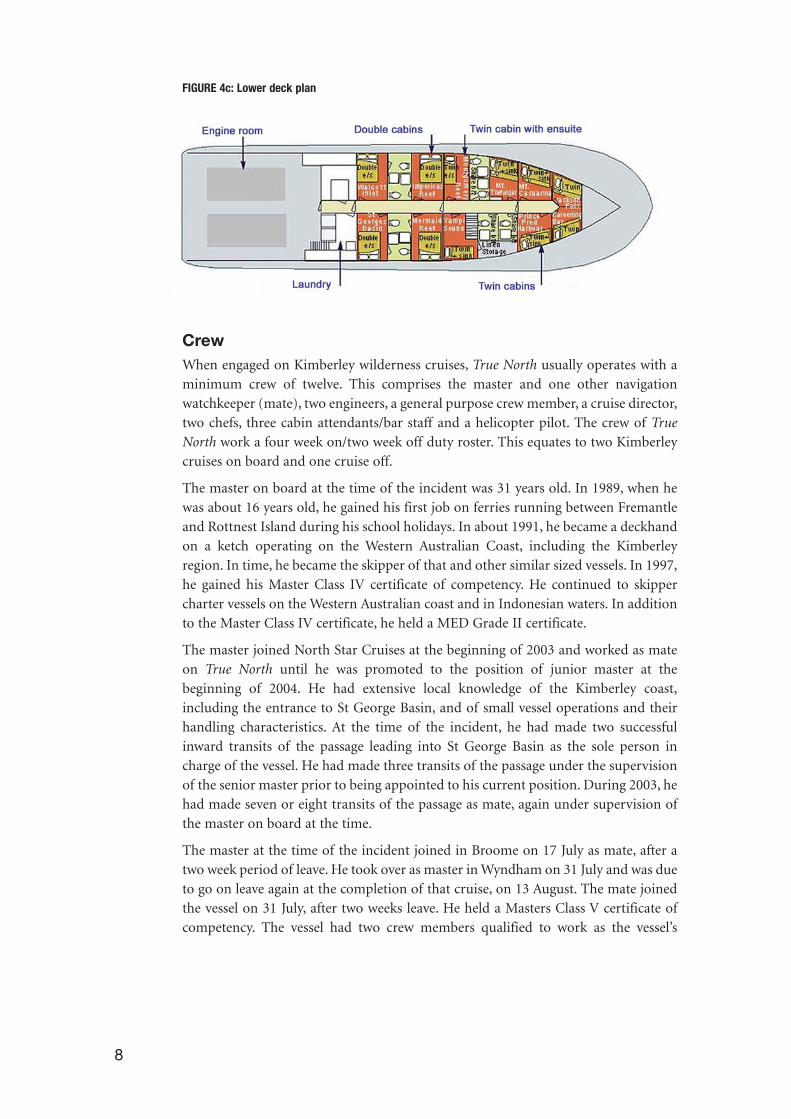
On board facilitiesUp to 26 passengers are accommodated on board True North in two staterooms, sixdouble cabins and five twin berth cabins. The two staterooms and two double cabinsare located on the middle deck with the remaining cabins located on the lowest deck.
The crew are accommodated in four cabins on the upper deck, behind thewheelhouse, and in two twin cabins on the lowest deck, forward of the passengercabins. With the exception of the master’s cabin, all the crew cabins are twin berth, ina bunk configuration.
Lounge and dining areas are provided for the passengers on the middle deck, just aftof the two staterooms. An under-cover recreational area and bar is provided on theupper deck, aft of the wheelhouse and crew accommodation. The vessel’s galley islocated on the middle deck, aft of the dining area. An outdoor cooking and fishpreparation area is located aft of the galley. Outdoor lounging facilities are providedon the upper deck, forward of the wheelhouse. This area is sheltered by a canopywhich extends about six metres forward from the wheelhouse.
FIGURE 4a: Upper deck plan
FIGURE 4b: Middle deck plan
7
8
FIGURE 4c: Lower deck plan
CrewWhen engaged on Kimberley wilderness cruises, True North usually operates with aminimum crew of twelve. This comprises the master and one other navigationwatchkeeper (mate), two engineers, a general purpose crew member, a cruise director,two chefs, three cabin attendants/bar staff and a helicopter pilot. The crew of TrueNorth work a four week on/two week off duty roster. This equates to two Kimberleycruises on board and one cruise off.
The master on board at the time of the incident was 31 years old. In 1989, when hewas about 16 years old, he gained his first job on ferries running between Fremantleand Rottnest Island during his school holidays. In about 1991, he became a deckhandon a ketch operating on the Western Australian Coast, including the Kimberleyregion. In time, he became the skipper of that and other similar sized vessels. In 1997,he gained his Master Class IV certificate of competency. He continued to skippercharter vessels on the Western Australian coast and in Indonesian waters. In additionto the Master Class IV certificate, he held a MED Grade II certificate.
The master joined North Star Cruises at the beginning of 2003 and worked as mateon True North until he was promoted to the position of junior master at thebeginning of 2004. He had extensive local knowledge of the Kimberley coast,including the entrance to St George Basin, and of small vessel operations and theirhandling characteristics. At the time of the incident, he had made two successfulinward transits of the passage leading into St George Basin as the sole person incharge of the vessel. He had made three transits of the passage under the supervisionof the senior master prior to being appointed to his current position. During 2003, hehad made seven or eight transits of the passage as mate, again under supervision ofthe master on board at the time.
The master at the time of the incident joined in Broome on 17 July as mate, after atwo week period of leave. He took over as master in Wyndham on 31 July and was dueto go on leave again at the completion of that cruise, on 13 August. The mate joinedthe vessel on 31 July, after two weeks leave. He held a Masters Class V certificate ofcompetency. The vessel had two crew members qualified to work as the vessel’s
engineers. One held a Marine Engine Driver (MED) Grade I certificate and the otherheld a MED Grade II certificate. Another crew member held a coxswains certificate.All these certificates of competency were issued by the Western Australian marineregulatory authority.
Life saving appliancesIn accordance with its statutory survey requirements, True North is equipped with arange of life saving appliances. This equipment includes:
• two liferafts (for a total of 50 persons)
• six lifebuoys
• 76 lifejackets
• pyrotechnics (stored in a locker in the wheelhouse)
• two radar transponders (in the liferafts)
• three handheld VHF radio transceivers
• a radar transponder (located in the wheelhouse) and
• a 406 MHz satellite Emergency Position Indicating Radio Beacon (EPIRB).
The passengers’ muster station is located on the starboard side of the upper deck, justforward of the wheelhouse. All of the passengers’ lifejackets are stored in a locker atthis muster station. Two liferafts are stowed on the middle deck, on the port andstarboard sides, aft of the tenders.
Navigational proceduresAt the time of the incident, it was the usual practice for watchkeepers on True Northto operate the vessel in a totally automatic navigation mode (‘auto-nav’ mode). Thismode consisted of the GPS smart antenna and GPS wheelhouse unit feeding positioninformation to the ECS. The ECS then fed navigational information into the autohelm unit via NMEA–01833 standard outputs. The auto-helm unit automaticallymaintained the vessel on a pre-programmed route. Experience on board had shownthat the auto helm maintained a consistent course and it was operated in this modewhen underway. Large alterations of course, however, were carried out manually,using the autopilot, after the ECS was disengaged temporarily. Hand steering, usingthe tiller, was only used for manoeuvring during berthing or unberthing operations.
Cruise operationsFor four months each year, starting in March, True North operates in the Kimberleycoast region of Western Australia. The vessel is engaged in ‘adventure tourism’,conducting seven and fourteen day wilderness cruises along 2 000 kilometres of theKimberley coastline. During these cruises, the vessel regularly navigates in rivers andother areas of shallow water and large tidal variations. When not conductingKimberley wilderness cruises, True North is engaged on cruises from Darwin to
9
3 National Marine Electronics Association (NMEA) – a standard that defines an electrical interface and dataprotocol for communications between marine instrumentation.
10
NT
WA
SA
Qld
NSW
ACT
Vic
Tas
Loca
tion
of in
cide
nt
St.G
eorg
e Ba
sin
Prin
ce R
egen
t R
iver
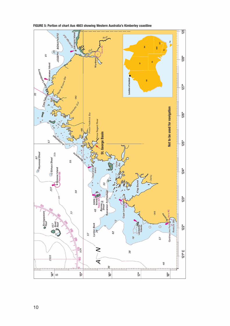
FIGURE 5: Portion of chart Aus 4603 showing Western Australia’s Kimberley coastline
Not t
o be
use
d fo
r na
viga
tion
Cairns, Rowley Shoal diving expeditions and cruises from Fremantle to NigalooIsland, in the Monte Bello Island Group to the west of Dampier. A number of othercharter vessels operate in the Kimberley coast region, however True North is thelargest vessel regularly conducting these types of cruises.
Five aluminium tenders, each equipped with outboard motors and VHF radios, arecarried on board True North. The tenders are used to ferry passengers ashore and toconduct activities during the cruises (fishing, etc). They are stowed on the middle andupper decks aft of the recreational areas. The tenders are operated by the vessel’s crewmembers.
When on Kimberley wilderness cruises, True North carries a Bell 407, single turbineengined helicopter. The helicopter is carried on the bridge top. It carries a maximumof seven people (a pilot and six passengers). The helicopter provides access to moreremote locations within the wilderness areas.
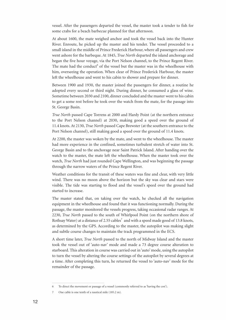
Prince Regent River and St. George BasinSt. George Basin (Fig. 6) is a body of water that lies about eleven nautical milesupstream from the mouth of the Prince Regent River, a large river at the head ofBrunswick Bay in the Kimberley region of Western Australia. Access by water-bornecraft to the Prince Regent River, and therefore St. George Basin, is gained through aseries of narrow waterways between Cape Wellington and Strong Tide Point. Theriver between Rothsay Water and Munster Water is disturbed by violent eddies andwhirlpools, which are caused by the rapid tidal streams which rush through theconfined channels. The rates of the tidal streams in the waterways vary with thewidths of the waterways in the river, but may attain between five and seven knots4.
About three nautical miles to the southeast of Greville Island, the passage narrows tobe about seven cables in width. A further two cables to the southeast, the width of thepassage narrows to about five cables. This is the narrowest part of the passage and isbounded by a rocky shoal to the south, and Strong Tide Point on the southern tip ofthe Marigui Promontory, to the north5. This narrow passage divides the MariguiPromontory and the Macdonald Ranges.
St. George Basin is unsurveyed and local knowledge is essential for mariners enteringthe Prince Regent River. There are no navigation aids within Prince Regent River orSt. George Basin.
The incidentAt 1720 on 31 July 2004, True North departed the Western Australian port ofWyndham for a 14 day/13 night wilderness cruise of the Kimberley coastal region.The final destination was the port of Broome. On board were 26 passengers and 12 crew. At 2110 on 6 August, True North anchored in the Roe River, which flows intoPrince Frederick Harbour.
At about 0600 on 7 August, the day’s routine began for all the crew, who beganorganising the pre-planned activities. At 1130, the master took the vessel a shortdistance to Porosous Creek, a tributary of the Hunter River. At 1240 he anchored the
11
4 One knot equals one nautical mile per hour and 1.852 km/h.
5 Australia Pilot Volume V, seventh edition 1992, page 147.
vessel. After the passengers departed the vessel, the master took a tender to fish forsome crabs for a beach barbecue planned for that afternoon.
At about 1600, the mate weighed anchor and took the vessel back into the HunterRiver. Enroute, he picked up the master and his tender. The vessel proceeded to asmall island in the middle of Prince Frederick Harbour, where all passengers and crewwent ashore for the barbeque. At 1845, True North departed the island anchorage andbegan the five hour voyage, via the Port Nelson channel, to the Prince Regent River.The mate had the conduct6 of the vessel but the master was in the wheelhouse withhim, overseeing the operation. When clear of Prince Frederick Harbour, the masterleft the wheelhouse and went to his cabin to shower and prepare for dinner.
Between 1900 and 1930, the master joined the passengers for dinner, a routine headopted every second or third night. During dinner, he consumed a glass of wine.Sometime between 2030 and 2100, dinner concluded and the master went to his cabinto get a some rest before he took over the watch from the mate, for the passage intoSt. George Basin.
True North passed Cape Torrens at 2000 and Hardy Point (at the northern entranceto the Port Nelson channel) at 2030, making good a speed over the ground of11.4 knots. At 2130, True North passed Cape Brewster (at the southern entrance to thePort Nelson channel), still making good a speed over the ground of 11.4 knots.
At 2200, the master was woken by the mate, and went to the wheelhouse. The masterhad more experience in the confined, sometimes turbulent stretch of water into St.George Basin and to the anchorage near Saint Patrick Island. After handing over thewatch to the master, the mate left the wheelhouse. When the master took over thewatch, True North had just rounded Cape Wellington, and was beginning the passagethrough the narrow waters of the Prince Regent River.
Weather conditions for the transit of these waters was fine and clear, with very littlewind. There was no moon above the horizon but the sky was clear and stars werevisible. The tide was starting to flood and the vessel’s speed over the ground hadstarted to increase.
The master stated that, on taking over the watch, he checked all the navigationequipment in the wheelhouse and found that it was functioning normally. During thepassage, the master monitored the vessels progress, taking occasional radar ranges. At2230, True North passed to the south of Whirlpool Point (on the northern shore ofRothsay Water) at a distance of 2.55 cables7 and with a speed made good of 13.8 knots,as determined by the GPS. According to the master, the autopilot was making slightand subtle course changes to maintain the track programmed in the ECS.
A short time later, True North passed to the north of Midway Island and the mastertook the vessel out of ‘auto-nav’ mode and made a 73 degree course alteration tostarboard. This alteration in course was carried out in ‘auto’ mode, using the autopilotto turn the vessel by altering the course settings of the autopilot by several degrees ata time. After completing this turn, he returned the vessel to ‘auto-nav’ mode for theremainder of the passage.
12
6 To direct the movement or passage of a vessel (commonly referred to as ‘having the con’).
7 One cable is one tenth of a nautical mile (185.2 m).
13
FIGURE 6: Portion of chart Aus 730 showing St. George Basin and approach passage

The master claimed he was referencing the cross-track error8 information displayedon a repeater situated on the centreline of the vessel, immediately in front of thewheel. He also claimed he was comparing information presented to him by the radarand electronic chart displays. According to the master, he used the clear radar imagesof the prominent land features to check the vessel’s progress, comparing theinformation displayed on the radar monitor to the vessel’s position being displayedon the ECS. There was no apparent discrepancy between the two displays to makehim think anything was amiss.
As True North approached Strong Tide Point, the master stated he took a radar rangeoff the point, which was 4.5 cables. The vessel appeared to be on the track to passthrough the most restricted section of the passage (five cables of navigable water).According to his statement, he moved to the port wheelhouse door, and looked out.He could not clearly see the land features on the port side of the vessel. He thenmoved out of the wheelhouse to the front of the upper deck, forward of thewheelhouse, for a ‘look around’. As he was returning to the port door of thewheelhouse, he could see and feel the vessel turning and sensed that something wasnot right. He hurried back into the wheelhouse and looked at the radar. As soon as hesaw the radar display, he could see a large area of ‘green’ (being the land) coming atthe vessel from port. True North was now steering directly for Strong Tide Point at aspeed over the ground of about 14 knots. The master quickly made his way to thecentre console and was only able to bring the engine controls to stop when, at 2304,True North took the ground. The vessel struck with enough force that, according tothe master, a ‘loud crunching’ sound could be heard in the wheelhouse and the entirevessel shuddered on impact.
After the groundingWhen it became apparent that True North was aground, the master checked that thevessel’s engines were out of gear. He then went to the lower deck to check for damageto the inside of the accommodation, and to ensure there was no water ingress into theaccommodation space. By this time, passengers and crew were emerging from theircabins to see what had happened. The cruise director and her assistants set aboutmoving the passengers and non-essential crew to the rear of the middle deck. Themaster, mate and chief engineer together assessed the situation and the masterdecided to enter the water to see if he could identify the extent of the damage.
On entering the water, with the aid of torchlight, the master could see that a large,sharp rock had penetrated the hull forward of the collision bulkhead. The impact hadforced the forward part of the vessel’s shell plating up and into the forward voidspace. The collision bulkhead was also damaged to the extent that water was enteringthe forward accommodation bilge space, just aft of the void space. He then returnedto the vessel. While the master was in the water, the first mate had removed the accesshatch in the lower deck, to assess the extent of damage to the collision bulkhead andforward accommodation bilge plating could be assessed. The bilge pumps werestarted.
During the time the vessel was aground, the crew established that only two forwardcompartments were taking water. It was apparent that the vessel was in no danger ofsinking. The passengers had been mustered and after establishing the extent of the
14
8 The distance the vessel is off the predetermined course.

damage, the master spoke to them. He ensured that no one was badly injured and thatthey all knew exactly the situation regarding the grounding and safety of the vessel.
True North remained aground until about 0025 on 8 August when the tide had risensufficiently to allow the vessel to be refloated. Using the engines, the master movedTrue North to an anchorage position just south of Saint Patrick Island, in St. GeorgeBasin, a distance of about 4.2 nautical miles from the grounding position. Theanchorage position was near several sandy beaches on Saint Patrick Island where theboat could be beached the following morning and a full assessment of the damagemade.
FIGURE 7: Strong Tide Point – location of grounding
(Photo courtesy of The Great Escape Charter Company, Broome, WA)
All equipment was removed from the forward section of the vessel. Any buoyantmaterial on board was moved to the area, including several inflatable fenders.
At 0100 on 8 August, using a satellite telephone, the master advised True North’ssenior master in Broome of the grounding. The senior master then informed thevessel’s owner and managers. Later that morning the vessel’s owners and managersheld a meeting in Broome to decide how to effect temporary repairs, given its remotelocation.
Overnight, the vessel remained at anchor and a watch was kept on the level of waterin the two damaged compartments.
At about 0700 on 8 August, the master beached True North on Saint Patrick Island.The extent of the damage was readily apparent and this was reported back to theowners and managers in Broome. With this knowledge, the decision was made to flya repair team, equipment and materials to St George Basin and to fly the passengersand non-essential crew to Broome. The master advised AMSA of the incident on themorning of 8 August.
15
Marigui Promontry
Grounding location
St George Basin

FIGURE 8: Grounding damage
During the day of 8 August, the passengers continued their exploration of thesurrounding area, including the Prince Regent River attractions, by helicopter andusing True North’s tenders. The passengers were made comfortable on the beach andthat evening, they returned to the vessel.
On the morning of 9 August, a repair team and the senior master departed Broomeon a floatplane. During 9 August, the passengers left True North and were flown toBroome.
Temporary repairsBetween 9 and 11 August, aluminium plates were welded over the area of damage inthe fore part of the vessel. This was done while the vessel was beached in between theperiods of high water. Internal bracing was welded in place and cement was pouredinto the temporary structure to provide additional rigidity. The temporary repairwork was completed by mid afternoon of 11 August. At 1510 that afternoon, thefloatplane departed St. George Basin with the repair team and four non-essential crewmembers on board.
At 1840 on 11 August, True North departed St. George Basin for Darwin, where thevessel was to be dry docked for permanent repairs. During the 430 nautical mile tripto Darwin, two people maintained navigation watches, with regular 1⁄2 hourly visualchecks made on the damaged areas. Only a very small amount of water was seen toenter the area and this was removed using the bilge pump. True North maintainedcontact with the Rescue Coordination Centre (RCC) in Canberra through regularAUSREP9 position reports. The vessel also maintained contact with pearling vesselsoperating in the area, in the event of assistance being required.
16
9 Australian Ship Reporting System
The weather was fair and when it was evident that the repairs would hold, thedecision to dispense with the helicopter was made by the senior master. At 1500 on12 August, the helicopter pilot and one other non-essential crew member left TrueNorth. This left seven crew members on board, the senior master, the master, the firstmate, the deck hand, both engineers and the chef.
The weather for the trip to Darwin remained fine with zero to ten knot, northwest tonortheast winds and seas between calm to slight. Speed during the trip rangedbetween seven and ten knots.
At about 2030 on 13 August, True North anchored in Darwin’s quarantine anchorage.At 0645 on 14 August, a Darwin harbour pilot boarded the vessel and it proceeded tothe ship repair wharf. By 0715, the vessel was secure alongside and the pilot departed.
Repairs were completed by 25 August and at 0545 the following morning, True Northdeparted Darwin for Wyndham, to resume its cruise schedule on the Kimberley coast.
17

18

19
4 COMMENT AND ANALYSIS
EvidenceOn 15 August 2004, two marine investigators from the Australian Transport SafetyBureau (ATSB) attended True North in Darwin. The master, senior master and vessel’sco-owner, who also serves as master on occasions, were interviewed and providedaccounts of the incident and subsequent repair operations. Copies of relevantdocuments were obtained including: log book entries, operations manuals, passengersafety information; various procedures and statutory certificates.
Data from the vessel’s ECS for the relevant days was downloaded and used in theanalysis of the incident.
Assistance and advice regarding the integrity and accuracy of the GPS system wasobtained from the School of Mathematical and Geospatial Sciences, RMIT University,Melbourne. Electrotech Australia (Darwin) tested the vessels GPS antenna and,together with Navigation Dynamics (Cairns), provided advice regarding the use ofECS.
The incidentTrue North grounded while transiting the Prince Regent River, in the entrance passageto St. George Basin, at about 2304 on 7 August 2004. The weather was fine and clear,and the tide was flooding at a rate of about 2.5 knots. At the time of the grounding,the vessel was being steered by the auto navigation system (‘auto-nav’ mode). At notime in the passage from Prince Frederick Harbour that day, did the watchkeepersobserve the ECS giving an indication of any positional errors, or cause them to haveany concern regarding the navigational accuracy of the system. The vessel wasfollowing established routes, previously entered into the ECS, and had notencountered any problems during past transits of the passage using the ‘auto-nav’mode.
At the time of the grounding, True North’s ECS indicated that the vessel was on courseand in safe water when it ran aground. There are a number of possible causes for theGPS/ECS errors which lead to this incorrect information being presented to thewatchkeeper. There are:
• GPS system inaccuracy
• Geodetic datum ambiguity
• A change in operating system
• A change in the GPS receiver parameters
• Loose wiring or connections in the on board systems or
• A combination of the above.
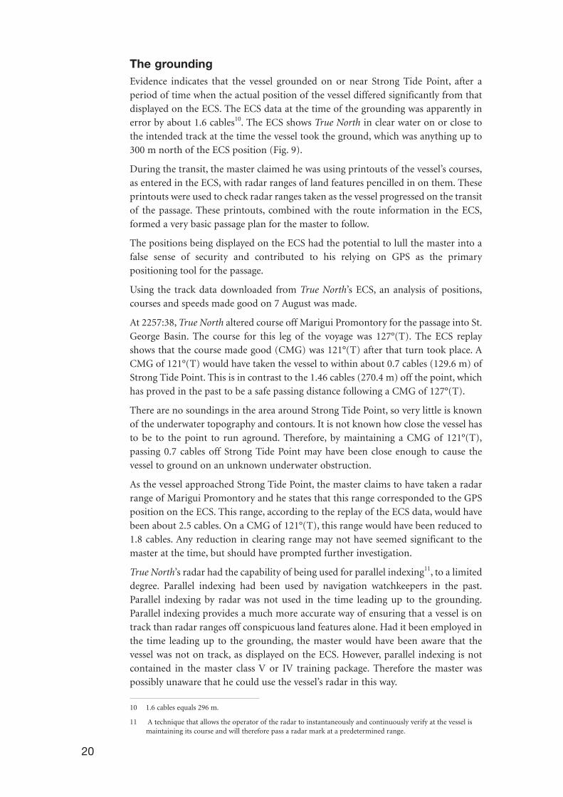
The groundingEvidence indicates that the vessel grounded on or near Strong Tide Point, after aperiod of time when the actual position of the vessel differed significantly from thatdisplayed on the ECS. The ECS data at the time of the grounding was apparently inerror by about 1.6 cables10. The ECS shows True North in clear water on or close tothe intended track at the time the vessel took the ground, which was anything up to300 m north of the ECS position (Fig. 9).
During the transit, the master claimed he was using printouts of the vessel’s courses,as entered in the ECS, with radar ranges of land features pencilled in on them. Theseprintouts were used to check radar ranges taken as the vessel progressed on the transitof the passage. These printouts, combined with the route information in the ECS,formed a very basic passage plan for the master to follow.
The positions being displayed on the ECS had the potential to lull the master into afalse sense of security and contributed to his relying on GPS as the primarypositioning tool for the passage.
Using the track data downloaded from True North’s ECS, an analysis of positions,courses and speeds made good on 7 August was made.
At 2257:38, True North altered course off Marigui Promontory for the passage into St.George Basin. The course for this leg of the voyage was 127°(T). The ECS replayshows that the course made good (CMG) was 121°(T) after that turn took place. ACMG of 121°(T) would have taken the vessel to within about 0.7 cables (129.6 m) ofStrong Tide Point. This is in contrast to the 1.46 cables (270.4 m) off the point, whichhas proved in the past to be a safe passing distance following a CMG of 127°(T).
There are no soundings in the area around Strong Tide Point, so very little is knownof the underwater topography and contours. It is not known how close the vessel hasto be to the point to run aground. Therefore, by maintaining a CMG of 121°(T),passing 0.7 cables off Strong Tide Point may have been close enough to cause thevessel to ground on an unknown underwater obstruction.
As the vessel approached Strong Tide Point, the master claims to have taken a radarrange of Marigui Promontory and he states that this range corresponded to the GPSposition on the ECS. This range, according to the replay of the ECS data, would havebeen about 2.5 cables. On a CMG of 121°(T), this range would have been reduced to1.8 cables. Any reduction in clearing range may not have seemed significant to themaster at the time, but should have prompted further investigation.
True North’s radar had the capability of being used for parallel indexing11, to a limiteddegree. Parallel indexing had been used by navigation watchkeepers in the past.Parallel indexing by radar was not used in the time leading up to the grounding.Parallel indexing provides a much more accurate way of ensuring that a vessel is ontrack than radar ranges off conspicuous land features alone. Had it been employed inthe time leading up to the grounding, the master would have been aware that thevessel was not on track, as displayed on the ECS. However, parallel indexing is notcontained in the master class V or IV training package. Therefore the master waspossibly unaware that he could use the vessel’s radar in this way.
20
10 1.6 cables equals 296 m.
11 A technique that allows the operator of the radar to instantaneously and continuously verify at the vessel ismaintaining its course and will therefore pass a radar mark at a predetermined range.
The master stated that he left the wheelhouse after taking the radar range of MariguiPromontory and went onto the deck in front of the wheelhouse. As he returned to thewheelhouse, he could see and feel the vessel turning to port (towards the northernshore) and hastened his return to the helm.
True North was travelling at a speed over the ground of approximately 14.5 knotswhen it grounded at 2304. This equates to 7.459 m/s. The 127°(T) course laid off onthe ECS passes about 270 m from Strong Tide Point. The vessel had to move about270 m from the charted course to being aground off the point. At the speed it wastravelling, the vessel would take 36 seconds to travel that 270 m. The ECS replay plotsthe vessel’s position every 10 seconds. A definite change to port in course over theground for that period of time would easily be seen on the ECS replay and plot (Fig.9).
There is no evidence of a substantial course or heading alteration to port prior to thegrounding.
FIGURE 9: ECS plot of vessel track leading up to grounding
Echo sounder and forward scanning sonar Neither the echo sounder nor the forward scanning sonar were operating at the timeof the grounding.
While echo sounders give the watchkeeper an indication of shoaling water under thevessel, the equipment provides very little assistance in the case of a vessel encounter-ing a ‘point obstruction’ in its path, such as a rock. It is not known if True North’s echosounder would have alerted the master to a possible danger because the nature of theunderwater contours was not known.
True North’s forward scanning sonar’s transducer had to be lowered beneath the hullof the vessel to allow the sonar to operate. The unit had been damaged on severaloccasions in the past and it was the practice on board not to use it when the vessel was
21

22
travelling on courses or routes in known safe water. In the time leading up to thegrounding, it was believed that True North was operating in water previouslytraversed which was clear of obstructions and underwater dangers, and the masterhad not deployed the transducer.
However, had the forward scanning sonar been operating, it may well have provideda warning of possible underwater dangers forward of the vessel, and allowed themaster to take avoiding action.
Standing ordersAt the time of the grounding, the company standing orders covering navigationalprocedures on board the vessel were brief and reportedly supplemented by verbalorders from the senior master. The orders, as posted in the wheelhouse and in thecompany procedures consisted of half a page of dot points, all general in theirdirections to the watchkeepers.
Standing orders, like all operating procedures, are to assist people to perform tasks.Good standing orders and procedures are a defence against mistakes or lapses thatmay manifest themselves in times of emergency or during periods of high stress onboard ships.
While there was no legal or company requirement for True North to have more thanone watchkeeper on watch during navigation in restricted or unsurveyed areas, it mayhave been prudent to ‘double up’ on watch during these transits. Having two personson navigational watch would have reduced the level of operational risk (caused by‘single person errors’) during navigation in these types of waterways.
At the time of the grounding, standing orders governing the appropriate use of GPSand the ‘auto-nav’ mode for navigating in close confined waters were non-existent.The decision to use this mode of navigation was left to the master on the vessel at thetime. The master on watch at the time of the grounding had taken the vessel throughthe passage on two other occasions, in his capacity as master. He had, however,completed several transits under instruction from the master when he was serving asmate in the vessel. He stated that he had not experienced any problems with thereliability of the GPS positions displayed on the ECS. He relied on the GPS and theautopilot to steer the vessel when he was on watch.
The navigational standing orders stated that regular checks must be made on the GPScross track error to ensure that the vessel stayed as close to track as possible and thatthe cross track error alarm must be turned on. The cross track limits were set to halfa cable (92.6 m). The master stated that at no time preceding the grounding did hesee the vessel exceed the cross track limits on the ECS nor did he hear the cross trackalarm sound. This is consistent with the GPS positions being almost on the track inthe ECS.
The standing orders also stated that the vessel’s position was to be monitored usingradar, ECS plotters and visual means to ensure that the vessel maintained its track andremained in safe water. While not written in documentation, the senior master hadissued advice to watchkeepers which required radar to be the primary navigation
23
means for position fixing. The radar and ECS displays are adjacent to each other onthe wheelhouse console and easily compared at a single glance. In addition, the GPSunit displayed CMG information and this was readily available to the watchkeeperduring his monitoring of the navigation of the vessel.
The evidence indicates that an adequate and proper check was not kept on the radarand visual situation in the short period of time the vessel was in the approach passageto St. George Basin. Too much reliance was placed on the accuracy of the GPSpositional data. Irrespective of whether the vessel appeared on the track as displayedby the ECS, had a careful check been maintained on the radar display, it would havebeen readily apparent that the vessel was steering into danger.
Since the grounding, the owners have revised the standing orders. The new standingorders formalise and improve some existing long standing practices in place at thetime of the grounding. They also expand the duties and responsibilities of the watchkeeper and include ensuring that the vessel shall not be navigated ‘by theautopilot in navigation mode i.e. the interface between the autopilot and the plottermust not be used’.
Use of tideTrue North was entering St. George Basin on a flood tide. This is the usual practice forthe vessel and saves both time and fuel by using the flow of the following tide. Theopposite is the case when departing the basin, i.e. use of the ebb tide. There is nogoverning rate of tide on which True North will not transit the passage. However,during maximum spring tidal flows, the time of transit will usually be adjusted so thatthe vessel is not in the passage at the maximum rate of flood or ebb.
Large vessels would normally stem the tide, to maximise the speed of water flow overthe rudder to enable the ship to maintain effective steerage at a lower speed. TrueNorth is a vessel with a shallow draught and relatively powerful engines that allow thevessel to maintain steerage even in a relatively rapid flowing tide.
GPS positioningGPS is a satellite-based radionavigation system developed by the United StatesDepartment of Defense. Using 24 orbiting satellites, GPS provides instantaneousposition, speed and accurate time information 24 hours a day anywhere on or nearthe Earth’s surface. The system is not 100 per cent accurate in its position calculation.Since the removal of ‘Selective Availability’12, civilian users of the GPS system (forabsolute positioning) can theoretically achieve 10 m horizontal and 15 m verticalaccuracy at a 95 per cent confidence level. This level of accuracy can be improved bythe use of Differential GPS (DGPS), which can achieve 2 m horizontal and 10 mvertical accuracy at a 95 per cent confidence level.
Satellite geometry is critical for good position fixing. This is reflected in theHorizontal Dilution of Position (HDOP)13 value. The lower a HDOP value, the betterthe satellite geometry relative to a GPS receiver’s location, and the higher the expectedposition accuracy.
12 The intentional degradation of the GPS signals by a time varying bias. Removed by the United StatesDepartment of Defense in May 2000.
13 Measurement of horizontal positional accuracy.

The GPS unit on board True North was a standard absolute positioning unit, and doesnot have DGPS capability. In addition, the area in which the vessel operates does nothave DGPS coverage.
The use of GPS has inherent errors associated with it and these errors must be takeninto account when positions are determined. They must also be taken into account byusers of GPS when relying on GPS for accurate position fixing in confined orunsurveyed waters. GPS, like all aids to navigation, has to be used in conjunction withother methods of navigation so that any errors in position fixing can be minimised.Too much reliance on one navigation aid, like GPS, is inherently dangerous.
GPS errors can be generally categorised as ‘noise’/‘bias’ errors and ‘blunders’.Noise/bias errors may result in typical ranging errors of around 15 m for each satelliteused in the position solution. This would be negligible for navigation purposes.Blunders, however, can result in errors ranging from a few hundred metres tohundred of kilometres. A list of some of the more common GPS errors can be foundin Annex 1.
Expert advice requested by the ATSB on the integrity of the GPS system indicates thatthere were no satellite outages at the time of the grounding. The close proximity ofthe land, combined with the low elevation of True North’s GPS antenna, means thatpossibly 31% (worse case scenario) of the sky to the north east of the vessel was notvisible to the GPS antenna (Fig. 10c). This is a large portion of sky and it contained anumber of GPS satellites. However, there were still seven satellites, with a sufficientHDOP, visible to the GPS antenna in the remainder of the sky able to provide areliable position fix (Fig. 10a) (Data sourced from Trimble Navigation, USA).
FIGURE 10a: GPS satellite visibility at time of grounding
24
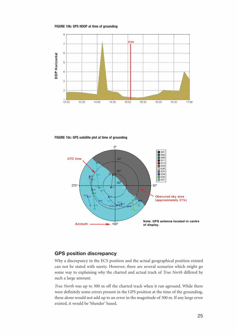
FIGURE 10b: GPS HDOP at time of grounding
FIGURE 10c: GPS satellite plot at time of grounding
GPS position discrepancyWhy a discrepancy in the ECS position and the actual geographical position existedcan not be stated with surety. However, there are several scenarios which might gosome way to explaining why the charted and actual track of True North differed bysuch a large amount.
True North was up to 300 m off the charted track when it ran aground. While therewere definitely some errors present in the GPS position at the time of the grounding,these alone would not add up to an error in the magnitude of 300 m. If any large errorexisted, it would be ‘blunder’ based.
25
26
True North uses the same routes in the ECS each voyage. Each route used is namedafter the area of operation. However, the various routes cannot be combined to forma single voyage. The route for the next leg of the voyage can only be entered into theECS at the arrival point on the preceding route.
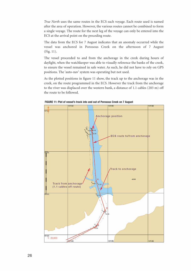
The data from the ECS for 7 August indicates that an anomaly occurred while thevessel was anchored in Porosous Creek on the afternoon of 7 August (Fig. 11).
The vessel proceeded to and from the anchorage in the creek during hours ofdaylight, when the watchkeeper was able to visually reference the banks of the creek,to ensure the vessel remained in safe water. As such, he did not have to rely on GPSpositions. The ‘auto-nav’ system was operating but not used.
As the plotted positions in figure 11 show, the track up to the anchorage was in thecreek, on the route programmed in the ECS. However the track from the anchorageto the river was displaced over the western bank, a distance of 1.1 cables (203 m) offthe route to be followed.
FIGURE 11: Plot of vessel’s track into and out of Porosous Creek on 7 August

27
The ECS route from Porosous Creek to St. George Basin was entered while the vesselwas at anchor in the creek. According to the crew, they neither made any changes tothe GPS receiver nor the programs running on the personal computer on which theECS operates. They also did not notice any problem with the computer when theroute within the ECS was changed at anchor, between 1242 and 1400 on 7 August.
The location of the grounding was the closest point that the vessel passed land on thepassage from Porosous Creek to St. George Basin. If the position error apparentleaving Porosous Creek is applied to the approach to St. George Basin, then TrueNorth would have been 1.1 cables to the north of the pre-programmed track, whichcould explain the grounding.
It is possible a change in the ECS operating system’s computer or GPS receiverparameters may have caused a problem with the GPS position data being plotted.
Dedicated computers for use with ECSTrue North was equipped with two personal computers mounted on the wheelhouseconsole, both of which ran ECS programs. These computers were not dedicated to theuse of the ECS alone and had other programs installed on them, related to the vessel’soperations – catering and the like.
ECS are susceptible to changes in computer operating system files which occur whenother programs are installed or deleted from the personal computer’s hard drive.Changes in these files may alter the operation of the electronic charting program,leading to errors and its incorrect operation. The most common problems come fromcomputers that are used for more than one task and have many programs loaded ontheir hard drives. This results in conflicts when the user attempts to multitaskbetween programs while running the ECS in the background.
It is most important that personal computers used for navigation be dedicated units.Expert advice sought on this problem indicates that ECS on dedicated personalcomputers seldom give any trouble.
It is possible that a change in the operational set up of True North’s ECS occurred atsome time before the grounding. This may have contributed to the inaccurate repre-sentation of the vessels positions on the ECS. There is no direct evidence to supportthis theory. However, there were no safeguards in place to prevent such a possibilityfrom happening.
Geodetic datumGeodetic datums are used to define the size and shape of the earth. Referencinggeodetic coordinates to the wrong datum can result in position errors of hundreds ofmetres. The diversity of datums in use today requires careful datum selection andcareful conversion between coordinates in different datums14.
GPS used the World Geodetic Survey 1984 (WGS84)15 datum to determine positions.If GPS equipment is incorrectly set up and not all positioning components set to thesame geodetic datum, then large positional errors can occur.
14 Peter H. Dana, Department of Geography, University of Texas at Austin, 1995.
15 Defined and maintained by the U.S. National Mapping & Imaging Agency (NMIA) as a global geodeticdatum. It is the datum to which all GPS positioning information is referred by virtue of being the referencesystem of the Broadcast Ephemeris.
Some of the geodetic datums currently in use around Australia include:
• WGS84,
• Geocentric Datum of Australia 1994 (GDA94),
• Australian Geodetic Datum 1984 (AGD84), and
• Australian Geodetic Datum 1966 (AGD66)16.
In the Prince Regent River region of Western Australia, the difference in positionsbetween WGS84 and the three listed datums are:
• GDA94 – coordinates read from GDA94 will be the same as those of WGS84,
• AGD84 to WGS84 – 161 m to the north and 137 m to the east
• AGD66 to WGS84 – 159 m to the north and 134 m to the east.
Practically, in most marine applications, AGD66 and AGD84 present the same errorin position. The error between AGD66/AGD84 and GDA94 (hence WGS84) positionsis about 200 m, in a direct line16.
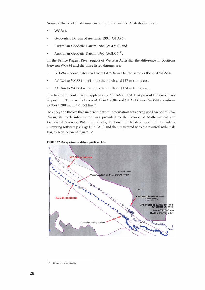
To apply the theory that incorrect datum information was being used on board TrueNorth, its track information was provided to the School of Mathematical andGeospatial Sciences, RMIT University, Melbourne. The data was imported into asurveying software package (LISCAD) and then registered with the nautical mile scalebar, as seen below in figure 12.
FIGURE 12: Comparison of datum position plots
28
16 Geoscience Australia.

The plot compares the ECS display using two datums, AGD84 and WGS84. The effectof this is that if True North was running its ‘auto-nav’ system on WGS84, with the GPSreceiver inadvertently logging ADG84, the plotted position would have been in errorby 1.1 cables (203 m) south of the true position relative to land. This happens to bethe distance the track was displaced when True North departed its anchorage inPorosous Creek.
If the northerly and easterly errors resulting in plotting AGD84 or AGD66 positionson a WGS84 chart are applied to the charted positions when the vessel left theanchorage, the vessel’s positions would be placed in the centre of the creek, on thepre-programmed route.
It could also explain the grounding on, or close to, Strong Tide Point.
The evidence that the wrong geodetic datum was being used is circumstantial,supported by the fact that the position of grounding closely coincides with theWGS84 datum position.
Accuracy of the electronic chartThe accuracy of the position of the charted land in electronic charts needs to be takeninto account when relying on GPS for accurate position fixing. The AustralianHydrographic Service (AHS) Seafarer chart produced for this area is Aus 730. Advicefrom the AHS is that this chart was first published in 1989 and that the topographyinformation used in its production was the best the AHS had at the time. A newedition of Aus 730 was produced in February 2003. Part of the reason for thepublication of a new edition was to shift the geodetic datum from AGD66 to WGS84.
True North was not navigating using official AHS Seafarer charts. The vessels ECS wasusing Transas electronic raster charts of the same area. These raster charts aredigitised reproductions of paper charts published by the AHS. While these charts arecorrect for WGS84 plotting, the accuracy of the position of the land depicted on theTransas AU730 chart can not be determined as the unsurveyed boundary may not beproperly presented.
GPS smart antennaWhile docked in Darwin for repairs, a technician attended True North and carried outa check of the GPS associated equipment. These checks found that several of theGPS/antenna connections on terminal blocks in the wheelhouse console were loose.The extent, if any, that these loose connections contributed to the GPS positiondiscrepancy is unknown.
The technician tested the antenna in order to establish whether there was any largeerror in the position information it passed to the GPS unit. The smart antenna, aRaytheon Raystar 112, did not show any extraneous error during the testing,maintaining a position within 10 m to 15 m from its exact location. This error inposition is within the 95 per cent confidence level expected for non-DGPS units.
If the particular GPS unit that True North had connected to its ECS loses a GPS signal,it does not default to dead reckoning (DR) navigation. Had there been inaccuratepositions derived from an interrupted signal, inconsistent positions would have been
29
30
evident. The ECS replay indicated a series of consistent positions in the minutesimmediately prior to the grounding, and no erroneous plots.
It was apparent from the observations of the antenna that it took between three andfour minutes for an accurate position to be derived after the unit was powered up. Itis not known if the power to the antenna was interrupted at any time prior to thegrounding.
The replay of the vessels tracks on the ECS does not indicate that there was any lossin GPS signal in the time leading up to the grounding. The ECS plotted track of thevessel is a regular track that does not depict loss of satellite or unacceptablepositioning. Were satellites dropped or extreme HDOP values present, variations inthe positions on the ECS would be apparent, being up to 500 m or 600 m in value.
Evidence indicates that there was no large position error that could be attributed tothe smart antenna in use at the time of the grounding.
At the request of the owners, the technician replaced the GPS smart antenna.
Master’s work schedule and level of alertnessBecause of the nature of the vessel’s operations and the requirement to carry only twoqualified watchkeepers, the master inevitably spent long periods directly supervisingthe navigation on passage. When at anchor, his duties extended to direct involvementin passenger activities.
The master had charge of the watch at the time of the grounding. He had beenworking almost continuously since 0600 that morning. He had taken over the watchfrom the mate at about 2200, after a short period of rest in his cabin. He had beenfollowing a similar daily work routine since taking over as master in Wyndham on 31 July, and had been on the vessel since 17 July, in his previous capacity as mate.During the four days immediately before the grounding, he was awake in excess of 16hours each day.
The master stated that he did not feel tired when he took over the watch from themate, even though he had been awake and busy all day, with the exception of the 45 minutes immediately prior to coming on watch. In the House of RepresentativesStanding Committee on Communications, Transport and the Arts report on fatiguein the Australian transport industry, ‘Beyond the Midnight Oil’, released in 2000, it isstated that:
A common perception equates fatigue with feeling sleepy or tired. In many cases,the research uses the terms fatigue and sleepiness interchangeably. However, manyresearchers differentiate fatigue from ‘sleepiness’ or ‘tiredness’. Tiredness may referto the ability to initiate sleep while fatigue refers to the ability to maintain jobsufficient alertness. By these definitions, it is possible to be fatigued but not feeltired. For example, the time of day may make it difficult to fall asleep even thougha person is fatigued. Further, sleepiness is a subjective state while fatigue involves aloss of objectively measurable performance capability over time.

The master provided his hours of work and recreation since the vessel departedWyndham on 31 July. This data was analysed using InterDynamics’ Fatigue AuditInterDyne (FAID) (software developed in conjunction with the Centre for SleepResearch at the University of South Australia) to assess his level of fatigue at the timeof the grounding.
FAID is primarily a rostering tool which calculates a ‘score’ for an individual’s level offatigue at a given time, based on their rostered tasks. These calculations take into con-sideration four factors that have emerged from research into shiftwork and fatigueover several decades. The specific determinates of work-related fatigue which FAIDtakes into account are:
1. the time of day of work and breaks;
2. the duration of work and breaks;
3. work history in the preceding seven days; and
4. the biological limits on recovery of sleep.
FAID does not make allowance for mode-specific environmental factors such asnoise, age, medical condition, light, vibration or the proximity to the workplace ofship’s crews. No allowance is made for any activity outside work hours such asdomestic tasks or, as in this case, socialising with passengers.
FAID results are given as an index score, which is plotted on the left of the graph.What the scores indicate is that a figure of:
- < 80 work related fatigue is unlikely,
- >80 to <100 some people will show signs of fatigue impairment on some tasks,
- >100 all people are likely to be impaired by any task.17
Research by the Centre for Sleep Research suggests that a fatigue score of 40 to 80 asbeing moderate, 80 to 100 as being high, with scores of 100 to 120 being very high.
A study conducted by the Centre for Sleep Research at the University of SouthAustralia, following the development of the FAID program, states that:
the impairment observed in an individual working with a fatigue score between 80 and 100 is comparable to the impairment of an individual intoxicated withalcohol to a blood alcohol content of 0.05% or greater.
Such a level of alcohol related impairment would not be acceptable at work.
Fatigue affects an individual’s performance in the following ways: forgetfulness;fixated on one task; apathetic; slowed reaction time; poor decision making; reducedvigilance; poor communications; bad mood; and being lethargic.
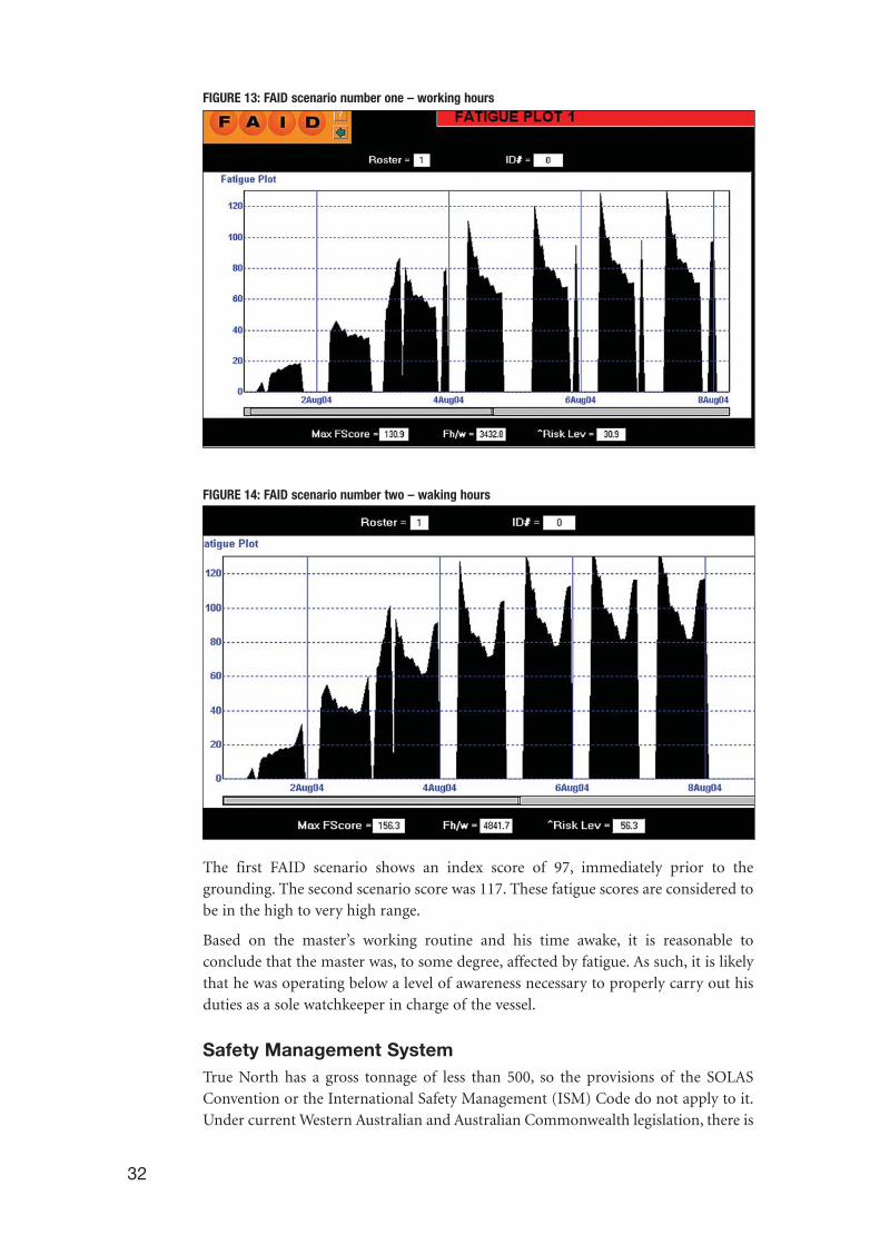
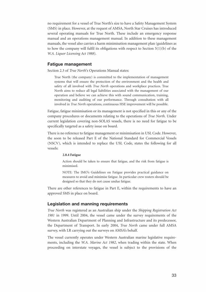
To examine the master’s fatigue level at the time of the incident, two FAID scenariowere considered. The first scenario (Fig. 13) uses only his hours of actual work on thevessel as the input, whereas the second scenario (Fig. 14) uses all of his waking hoursas the input parameters. The actual score probably lies somewhere between these twoscenarios.
31
17 Professor Drew Dawson - Centre for Sleep Research, University of South Australia.
32
FIGURE 13: FAID scenario number one – working hours
FIGURE 14: FAID scenario number two – waking hours
The first FAID scenario shows an index score of 97, immediately prior to thegrounding. The second scenario score was 117. These fatigue scores are considered tobe in the high to very high range.
Based on the master’s working routine and his time awake, it is reasonable toconclude that the master was, to some degree, affected by fatigue. As such, it is likelythat he was operating below a level of awareness necessary to properly carry out hisduties as a sole watchkeeper in charge of the vessel.
Safety Management SystemTrue North has a gross tonnage of less than 500, so the provisions of the SOLASConvention or the International Safety Management (ISM) Code do not apply to it.Under current Western Australian and Australian Commonwealth legislation, there is
33
no requirement for a vessel of True North’s size to have a Safety Management System(SMS) in place. However, at the request of AMSA, North Star Cruises has introducedseveral operating manuals for True North. These include an emergency responsemanual and an operations management manual. In addition to these managementmanuals, the vessel also carries a harm minimisation management plan (guidelines asto how the company will fulfil its obligations with respect to Section 5(1)(b) of theW.A. Liquor Licensing Act 1988).
Fatigue managementSection 2.3 of True North’s Operations Manual states:
True North (the company) is committed to the implementation of managementsystems that will ensure the protection of the environment and the health andsafety of all involved with True North operations and workplace practices. TrueNorth aims to reduce all legal liabilities associated with the management of ouroperation and believe we can achieve this with sound communication, training,monitoring and auditing of our performance. Through consultation with allinvolved in True North operations, continuous HSE improvement will be possible.
Fatigue, fatigue minimisation or its management is not specified in this or any of thecompany procedures or documents relating to the operations of True North. Undercurrent legislation covering non-SOLAS vessels, there is no need for fatigue to bespecifically targeted as a safety issue on board.
There is no reference to fatigue management or minimisation in USL Code. However,the soon to be released Part E of the National Standard for Commercial Vessels(NSCV), which is intended to replace the USL Code, states the following for allvessels:
2.8.4 Fatigue
Action should be taken to ensure that fatigue, and the risk from fatigue isminimised.
NOTE: The IMO’s Guidelines on Fatigue provides practical guidance onmeasures to avoid and minimise fatigue. In particular crew rosters should bedesigned so that they do not cause undue fatigue.
There are other references to fatigue in Part E, within the requirements to have anapproved SMS in place on board.
Legislation and manning requirementsTrue North was registered as an Australian ship under the Shipping Registration Act1981 in 1999. Until 2004, the vessel came under the survey requirements of theWestern Australian Department of Planning and Infrastructure and its predecessor,the Department of Transport. In early 2004, True North came under full AMSAsurvey, with LR carrying out the surveys on AMSA’s behalf.
The vessel currently operates under Western Australian marine legislative require-ments, including the W.A. Marine Act 1982, when trading within the state. Whenproceeding on interstate voyages, the vessel is subject to the provisions of the
Navigation Act 1912, and some of its subordinate legislation, including Marine Notice02/2002. True North is not a ‘Declared Vessel18’ under Section 8AA of the NavigationAct 1912.
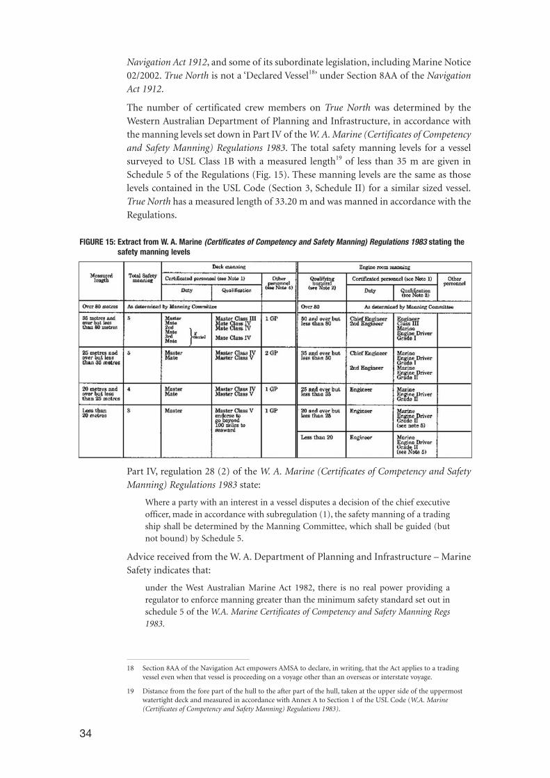
The number of certificated crew members on True North was determined by theWestern Australian Department of Planning and Infrastructure, in accordance withthe manning levels set down in Part IV of the W. A. Marine (Certificates of Competencyand Safety Manning) Regulations 1983. The total safety manning levels for a vesselsurveyed to USL Class 1B with a measured length19 of less than 35 m are given inSchedule 5 of the Regulations (Fig. 15). These manning levels are the same as thoselevels contained in the USL Code (Section 3, Schedule II) for a similar sized vessel.True North has a measured length of 33.20 m and was manned in accordance with theRegulations.
FIGURE 15: Extract from W. A. Marine (Certificates of Competency and Safety Manning) Regulations 1983 stating the safety manning levels
Part IV, regulation 28 (2) of the W. A. Marine (Certificates of Competency and SafetyManning) Regulations 1983 state:
Where a party with an interest in a vessel disputes a decision of the chief executiveofficer, made in accordance with subregulation (1), the safety manning of a tradingship shall be determined by the Manning Committee, which shall be guided (butnot bound) by Schedule 5.
Advice received from the W. A. Department of Planning and Infrastructure – MarineSafety indicates that:
under the West Australian Marine Act 1982, there is no real power providing aregulator to enforce manning greater than the minimum safety standard set out inschedule 5 of the W.A. Marine Certificates of Competency and Safety Manning Regs1983.
34
18 Section 8AA of the Navigation Act empowers AMSA to declare, in writing, that the Act applies to a tradingvessel even when that vessel is proceeding on a voyage other than an overseas or interstate voyage.
19 Distance from the fore part of the hull to the after part of the hull, taken at the upper side of the uppermostwatertight deck and measured in accordance with Annex A to Section 1 of the USL Code (W.A. Marine(Certificates of Competency and Safety Manning) Regulations 1983).
Had the WA marine authorities reviewed, or wanted to review, the certificatedmanning of True North, the state marine legislation therefore could not compel thecompany to employ additional certificated navigation or engineering personnel forthe vessel’s safety manning.
AMSA Marine Notice 02/2002 (Regulatory Requirements for Vessels on Near-CoastalVoyages Subject to the Navigation Act) applied to the vessel when its engaged oninterstate voyages. This Marine Notice states:
Operators of vessels engaged in, or wishing to undertake, inter-state voyages orothers voyages to which the navigation Act applies, are required to provide thenearest AMSA office with detailed information on the current or proposed vesseloperations as soon as possible. Based on this information, AMSA will assess orreassess its requirements for the vessel and inform the vessel operator accordingly.Assessment will comprise of:
• Vessel size, type and area of operation;
• Proposed manning levels;
• Competency levels/qualifications held;
• Communications equipment requirements; and
• State and Territory survey certificates held.
This legislation gives AMSA the right to modify the manning requirements of TrueNorth when it is engaged on inter-state voyages only, should AMSA consider itnecessary to do so, given the circumstances of the operations of the vessel.
Passenger emergency proceduresAs part of the investigation into True North’s grounding, passengers were asked tocomplete a questionnaire (Annex 2). The aim of the questionnaire was to:
• ensure persons directly involved in the grounding were give an opportunity toprovide information that they felt may be relevant;
• provide a passenger perspective on the emergency response; and
• assess whether any improvements in emergency procedures are necessary.
The questionnaire focused on:
• the safety information available to passengers before the incident;
• the passengers’ reaction to the emergency; and
• any suggestions by the passengers to improve the effectiveness of emergencyprocedures.
Twenty one of 26 passengers responded. Five of those who responded were in the agebracket 31–45 years; eight in the 46–60 year age bracket; and eight were over 60 yearsof age. Twelve of the passengers had travelled on a commercial vessel more than fourtimes prior to their trip on True North. One of the passengers had a physical disabilitythat affected mobility.
According to the passengers, they were provided with a safety briefing at a ‘welcomeaboard’ party held on the evening of 31 July in the bar, after the vessel had leftWyndham. At the briefing, the information passed to the passengers was purely verbal
35
36
and there was no visual, written or ‘hands on’ element to it – the passengers were notasked to put on a lifejacket.
In submission, True North Cruises stated that:
The master of the vessel strongly disputes this statement – a visual demonstrationof donning a life jacket is always included in True North’s safety demonstration and[True North Cruises] is assured that such a demonstration was included in thebriefing provided to this passenger group.
and
It is standard practice to brief the passengers in the vessel’s bar area – this area isimmediately aft of the upper deck accommodation area and, the muster point isimmediately forward of the upper deck accommodation area. The briefing isconducted in the bar because passengers are more comfortable in this position and,therefore more likely to pay attention to the briefing. The location of the actualmuster point and the location of the life jackets are clearly indicated from thislocation.
Sixteen passengers rated the briefing at the time it was given as adequate and easy tounderstand. In contrast, five passengers disagreed. However, after the grounding, sixof those sixteen passengers changed their views and considered that the briefingshould have been more comprehensive. Seventeen passengers considered that, as aresult of the briefing, they knew what to do when the vessel grounded.
True North did not carry safety information in the passenger cabins, but safety noticeswere posted in the public rooms. To test the effectiveness of these notices, passengerswere asked, ‘do you recall seeing any safety information posted around the vessel?’.Fifteen of the 21 passengers responding to the questionnaire could not recall seeingor remembering information contained in these notices.
Section 15, paragraphs 6.5 and 6.6 of the USL Code, as legislated by regulation five ofthe W.A. Marine (Emergency Procedures and Safety of Navigation) Regulations 1983,state that:
Passenger Emergency Procedures Notice shall include the following information:
(a) Cabin number and berth letter where applicable;
(b) Emergency signal;
(c) Action to take on hearing emergency signal in or near your own cabin;
(d) Action to take when not in or near own cabin;
(e) Location of lifejackets;
(f) Location of Emergency Station;
(g) Survival Craft allocation; and
(h) Abandon ship signal.
and
Notices showing how to don and secure lifejackets shall be displayed in everypassenger cabin and in conspicuous places throughout the passenger spaces andthese notices shall include information on how to adjust the lifejackets of children.
An examination of passenger cabins, and the information kits in those cabins, by theATSB revealed that the above information was not provided for the passengers.

37
The vessel’s owners should have provided the above information to comply with theprovisions of the W.A. Marine (Emergency Procedures and Safety of Navigation)Regulations 1983. Despite the evident deficiencies, the vessel had been issued thenecessary State and Commonwealth certificates to enable it to operate.
When True North grounded, all passengers were in their cabins, either in bed orpreparing to go to bed. It is apparent that most of the passengers felt the groundingand realised that something potentially serious had happened, although the generalalarm or emergency signal had not been sounded and no announcement had beenmade on the public address system. Three of the passengers were alerted to theincident by the crew.
In submission, True North Cruises stated that:
At the time of the incident, the crew used reasonable common sense with regard tothe issue of jackets and the sounding of signals. With specific regard to the actualcircumstance, the issue of life jackets and the sounding of signals were deemed tobe unnecessary as the vessel was assessed to be in no danger of sinking and,passengers had been mustered and accounted for.
All but one of the passengers found their way or were guided to the improvisedmuster point on the after upper deck within three minutes of the grounding. Fifteenof the passengers took no personal possessions, though six took wallets, phones, lap-top computers and other valuables. One passenger, subject to a strict medicationregime, did not take her medication to the muster station and was concerned that shedid not have her medication if they should be ordered to abandon the vessel.
One passenger reported that he did not reach the muster position for at least tenminutes, having been thrown out of bed and stunned by the fall when True Northtook the ground. This would suggest that a roll call was not conducted until sometime after the muster of passengers. Given the size of the vessel and the limitednumber of passengers on board, the delay in detecting a missing passenger requires areview of procedures aboard.
According to the majority of the passengers questioned, the crew remained calm, pro-fessional and reassuring throughout the incident.
In general the passengers reflected a range of views. The most relevant being:
• the muster station being changed without explanation;
• lifejackets were not distributed and worn as a precaution;
• the tenders were not put in the water as a precaution;
• the passengers were allowed back to their cabins to sleep before the damage wasproperly assessed and the position properly explained; and
• passengers on medication should be encouraged to carry their prescription toany emergency muster.
In submission, True North Cruises stated that:
Passengers do not necessarily have any expertise or knowledge that would allowthem to make qualified comment regarding this or any other marine incident.
and
Passengers that have endured severe disruption to holiday arrangements should notbe relied on with regard to the making of objective statement.
38
FIGURE 16: Events and causal factor chart
Even
tsCo
nditi
ons
Inci
dent
39
5 CONCLUSIONS
These conclusions identify the different factors that contributed to the incident andshould not be read as apportioning blame or liability to any particular individual ororganisation.
Based on the available evidence, the following factors are considered to havecontributed to the grounding of True North in the entrance to St. George Basin on 7 August 2004:
1. True North grounded on or near Strong Tide Point in unsurveyed waters whilebeing navigated by an auto helm unit and ECS receiving position informationfrom GPS satellites.
2. GPS derived positions plotted on the ECS differed from the vessel’s true position,possibly caused by:
a. GPS system inaccuracy;
b. Geodetic datum ambiguity;
c. The ECS operating on a common user personal computer which allowedpossible corruption of the ECS operating system;
d. A change in the GPS receiver parameters;
e. Loose wiring or connections in the on board systems; or
f. A combination of the above.
3. Too much reliance was placed on the accuracy of GPS positions and the GPSpositions plotted on the vessel’s ECS were not adequately checked by other navigational means.
4. A proper lookout was not maintained by visual, radar and other means to ensurethe vessel remained in safe water.
5. At the time of the grounding, it is probable that the master was suffering fromsome effects of fatigue as a result of his work routine.
6. There were deficiencies in the procedures which dealt with the mustering ofpassengers in that:
a. The initial safety briefing was not sufficiently comprehensive;
b. company orders in respect of lifejackets and emergency signals were notfollowed; and
c. company practices in the provision of emergency information andprocedures did not meet WA legislative requirements.

40

41
6 RECOMMENDATIONS
MR20050006
Owners and operators of vessels running Electronic Chart Systems should do so ondedicated computers.
MR20050007
Owners, operators and masters of vessels regularly operating in confined watersshould revise procedures governing the use of GPS and auto pilot systems.
MR20050008
Owners and operators of passenger vessels should ensure information concerningmuster areas, emergency signals and instructions and diagrams of how to donlifejackets, are included in any passenger information kits in cabins, and on the insideof all cabin doors, in order to comply with state/territory regulations.
MR20050009
True North Cruises should review the procedures associated with passenger briefingsand the emergency information displayed in the passenger cabins and vessel commonrooms.
MR20050010
Owners, operators and masters of non-SOLAS vessels should consider the introduc-tion of effective fatigue management policies and practices on board vessels.
MR20050011
AMSA and state/territory marine authorities should carefully consider the type ofoperation and area of operation when determining the safety manning of vessels ofany length.
MR20050012
Western Australia’s Department of Planning and Infrastructure should consider rec-ommending the amendement of WA marine legislation to allow for the option toreview and, if necessary, change the safety manning requirements for state registeredvessel.

42

43
7 SUBMISSIONS
Under Part 4, Division 2 (Investigation Reports), Section 26 of the Transport SafetyInvestigation Act 2003, the Executive Director may provide a draft report, on a confi-dential basis, to any person whom the Executive Director considers appropriate.Section 26 (1) (a) of the Act allows a person receiving a draft report to makesubmissions to the Executive Director about the draft report.
The final draft of this report was sent to the owners, senior master and master of TrueNorth, the Western Australian Department of Planning and Infrastructure – MarineSafety, AMSA and the School of Mathematical and Geospatial Sciences, RMITUniversity, Melbourne.
Submissions were included and/or the text of the report was amended whereappropriate.

44
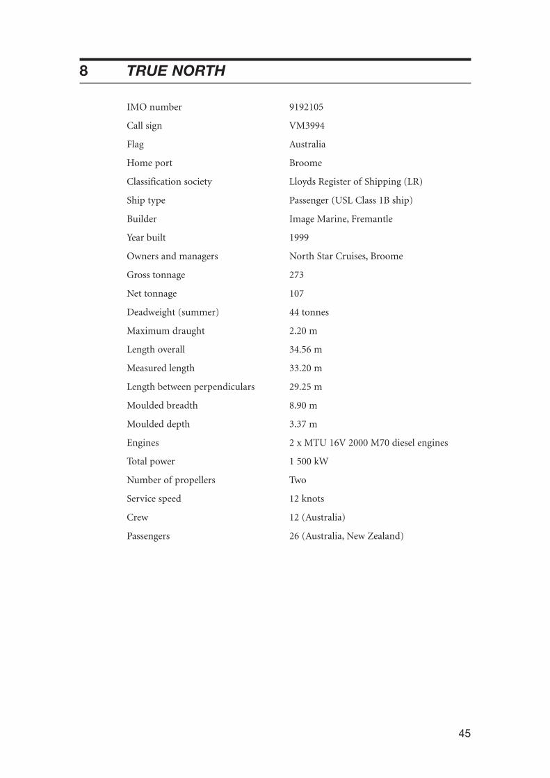
45
8 TRUE NORTH
IMO number 9192105
Call sign VM3994
Flag Australia
Home port Broome
Classification society Lloyds Register of Shipping (LR)
Ship type Passenger (USL Class 1B ship)
Builder Image Marine, Fremantle
Year built 1999
Owners and managers North Star Cruises, Broome
Gross tonnage 273
Net tonnage 107
Deadweight (summer) 44 tonnes
Maximum draught 2.20 m
Length overall 34.56 m
Measured length 33.20 m
Length between perpendiculars 29.25 m
Moulded breadth 8.90 m
Moulded depth 3.37 m
Engines 2 x MTU 16V 2000 M70 diesel engines
Total power 1 500 kW
Number of propellers Two
Service speed 12 knots
Crew 12 (Australia)
Passengers 26 (Australia, New Zealand)

46
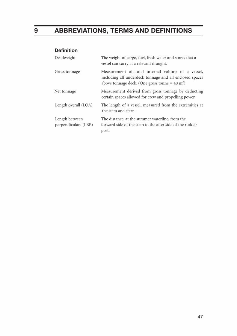
47
9 ABBREVIATIONS, TERMS AND DEFINITIONS
DefinitionDeadweight The weight of cargo, fuel, fresh water and stores that a
vessel can carry at a relevant draught.
Gross tonnage Measurement of total internal volume of a vessel,including all underdeck tonnage and all enclosed spacesabove tonnage deck. (One gross tonne = 40 m3)
Net tonnage Measurement derived from gross tonnage by deductingcertain spaces allowed for crew and propelling power.
Length overall (LOA) The length of a vessel, measured from the extremities atthe stem and stern.
Length between The distance, at the summer waterline, from the perpendiculars (LBP) forward side of the stem to the after side of the rudder
post.

48
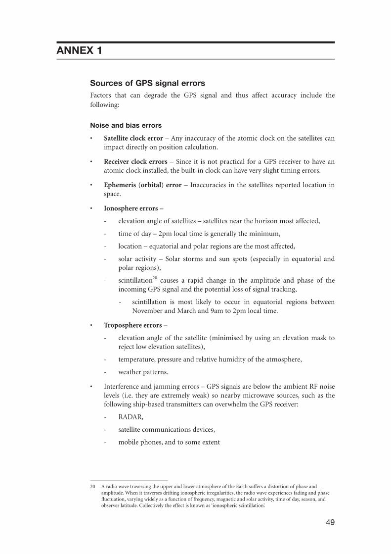
49
ANNEX 1
Sources of GPS signal errorsFactors that can degrade the GPS signal and thus affect accuracy include thefollowing:
Noise and bias errors
• Satellite clock error – Any inaccuracy of the atomic clock on the satellites canimpact directly on position calculation.
• Receiver clock errors – Since it is not practical for a GPS receiver to have anatomic clock installed, the built-in clock can have very slight timing errors.
• Ephemeris (orbital) error – Inaccuracies in the satellites reported location inspace.
• Ionosphere errors –
- elevation angle of satellites – satellites near the horizon most affected,
- time of day – 2pm local time is generally the minimum,
- location – equatorial and polar regions are the most affected,
- solar activity – Solar storms and sun spots (especially in equatorial andpolar regions),
- scintillation20 causes a rapid change in the amplitude and phase of theincoming GPS signal and the potential loss of signal tracking,
- scintillation is most likely to occur in equatorial regions betweenNovember and March and 9am to 2pm local time.
• Troposphere errors –
- elevation angle of the satellite (minimised by using an elevation mask toreject low elevation satellites),
- temperature, pressure and relative humidity of the atmosphere,
- weather patterns.
• Interference and jamming errors – GPS signals are below the ambient RF noiselevels (i.e. they are extremely weak) so nearby microwave sources, such as thefollowing ship-based transmitters can overwhelm the GPS receiver:
- RADAR,
- satellite communications devices,
- mobile phones, and to some extent
20 A radio wave traversing the upper and lower atmosphere of the Earth suffers a distortion of phase andamplitude. When it traverses drifting ionospheric irregularities, the radio wave experiences fading and phasefluctuation, varying widely as a function of frequency, magnetic and solar activity, time of day, season, andobserver latitude. Collectively the effect is known as ‘ionospheric scintillation’.
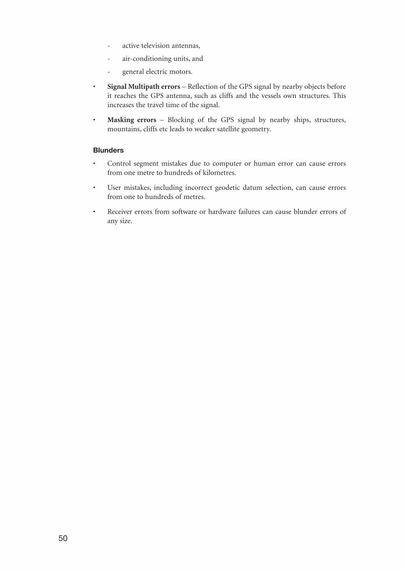
50
- active television antennas,
- air-conditioning units, and
- general electric motors.
• Signal Multipath errors – Reflection of the GPS signal by nearby objects beforeit reaches the GPS antenna, such as cliffs and the vessels own structures. Thisincreases the travel time of the signal.
• Masking errors – Blocking of the GPS signal by nearby ships, structures,mountains, cliffs etc leads to weaker satellite geometry.
Blunders
• Control segment mistakes due to computer or human error can cause errorsfrom one metre to hundreds of kilometres.
• User mistakes, including incorrect geodetic datum selection, can cause errorsfrom one to hundreds of metres.
• Receiver errors from software or hardware failures can cause blunder errors ofany size.

51
ANNEX 2
True North passenger questionnaire
Name Cabin name
1. Age and gender of those covered Age Male Femaleby this response as of 8 August 2004 <6
6–11
12–18
19–30
31–45
46–60
61–75
76 or over
2. At the time of the incident, did you Nohave a physical disability? Yes
If yes, please specify:VisionHearingMobilityOther (please specify)
3. How many times have you traveled on More thana commercial ship or vessel, including 0 1–2 2–4 4True North?
4. Did you find the safety briefing to you given by the master on joining True North:(a) adequate and (a) Yes or No(b) easy to understand? (b) Yes or No
5. Were you provided with any Noadditional safety information when you Yesboarded, or during the voyage? If yes, did it help you?
6. Do you recall seeing any safety Yesinformation posted around the vessel? No
If yes, did it help you?
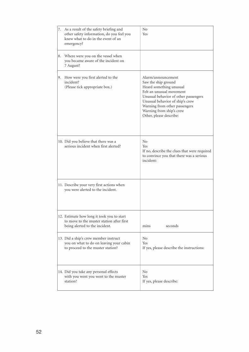
52
7. As a result of the safety briefing and Noother safety information, do you feel you Yesknew what to do in the event of an emergency?
8. Where were you on the vessel when you became aware of the incident on 7 August?
9. How were you first alerted to the Alarm/announcement incident? Saw the ship ground(Please tick appropriate box.) Heard something unusual
Felt an unusual movementUnusual behavior of other passengersUnusual behavior of ship’s crewWarning from other passengersWarning from ship’s crew Other, please describe:
10. Did you believe that there was a No serious incident when first alerted? Yes
If no, describe the clues that were required to convince you that there was a serious incident:
11. Describe your very first actions when you were alerted to the incident.
12. Estimate how long it took you to start to move to the muster station after first being alerted to the incident. mins seconds
13. Did a ship’s crew member instruct Noyou on what to do on leaving your cabin Yesto proceed to the muster station? If yes, please describe the instructions:
14. Did you take any personal effects No with you went you went to the muster Yes station? If yes, please describe:

53
15. Were there enough crew members to No assist the passengers during the incident? Yes
16. Please describe how the crew behaved while assisting the passengers.
17. Were there any specific examples of Nopassenger behaviour you would like to Yescomment on? If yes, please describe:
18. On your way to the muster station, Nodid you see any passengers going back Yesto their cabins? If yes, did this cause congestion or slow the
mustering process?
19. At the muster station, were you Notold what the incident was? Yes
By whom? Crew Other passenger
20. While at the muster station, were you By the crew Public addresssystem kept informed of what was going on? No No
Yes Yes
21. Were you aware of a roll call or head Nocount at the muster station? Yes
Comment:
22. Were life jackets passed out at the No muster station? Yes
If yes, what did you do with it?
23. If you put a life jacket on, how did Put it on without help you put it on? Shown by crew member
Assisted by crew memberOther, please specify:
24. Was the vessel’s public address Nosystem used during the incident? Yes
Comment:
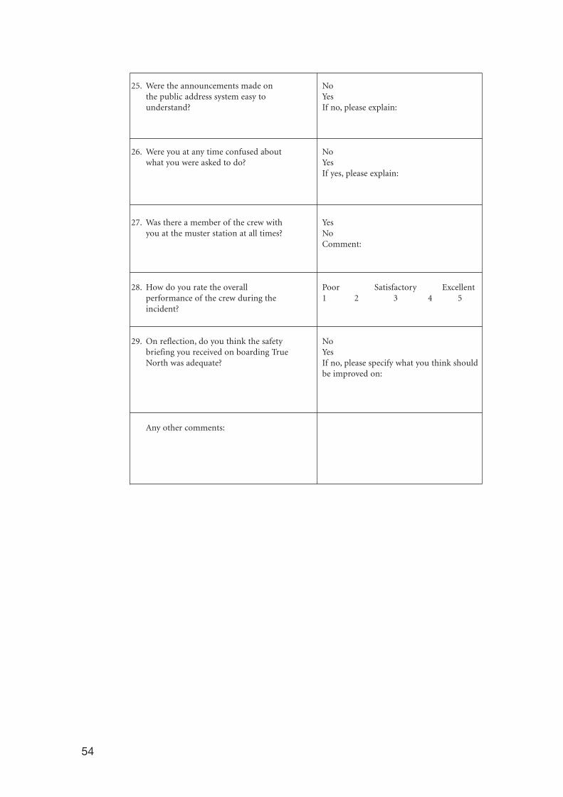
54
25. Were the announcements made on Nothe public address system easy to Yesunderstand? If no, please explain:
26. Were you at any time confused about Nowhat you were asked to do? Yes
If yes, please explain:
27. Was there a member of the crew with Yesyou at the muster station at all times? No
Comment:
28. How do you rate the overall Poor Satisfactory Excellentperformance of the crew during the 1 2 3 4 5incident?
29. On reflection, do you think the safety Nobriefing you received on boarding True YesNorth was adequate? If no, please specify what you think should
be improved on:
Any other comments:

55

56

Independent investigation into the grounding of the Australian registered passenger vesselTrue North
in the approach passage to St.George Basin,Western Australia,7 August 2004
ISS
N 1447-087X
ISB
N 1 877071 93 5
ww
w.a
tsb.
gov.
au18
00 6
21 3
72
True North 04.05


