Maremma · DIVING IN MAREMMA 3 2 1 PUNTA CAPEL ROSSO SMALL CAVES IN CALA DELL’ALLUME CALA CUPA...
32
Maremma T U S C A N Y DIVING IN MAREMMA
Transcript of Maremma · DIVING IN MAREMMA 3 2 1 PUNTA CAPEL ROSSO SMALL CAVES IN CALA DELL’ALLUME CALA CUPA...
MaremmaT U S C A N Y
DIVING IN MAREMMA


13 THE ISLAND OF GIANNUTRI
The wreck of the NasimThe Arches
14
16
18 MONTE ARGENTARIO
Cala dei SantiIslet of Porto ErcoleScoglio dell’Argentarola
19
21
23
25FORMICHE DI GROSSETO
Formica GrandeSecca dello Zì Paolo
26
28
30 USEFUL INFORMATION
14
INTRODUCTION 5
ISLAND OF GIGLIO Cala CupaSmall Caves in Cala dell’AllumePunta Capel Rosso
7
9
11
6
s u m m a r yDIVING IN MAREMMA


A pleasant mix of high sheer rock faces suddenly giving way to beautiful and tem-pting bays of sand and rock pools and long stretches of beach, from the whiter and finer sand of Cala Violina in the north to the larger and darker iron-based sand of the beaches to the south, on the coastline near Capalbio.
This is the part of the Maremma facing onto the crystalline waters of the Tyrrhenian Sea; never the same and never boring along the coastline and always providing something unexpected for those who spend their seaside holidays there. The sea along the Maremma coastline is one with long waves, varying from shades of blue, where the horizon separating the sea from the sky is almost imperceptible, to a more intense green colour where the waves batter the shoreline, providing a spectacle which is always emotional.
The old hamlets along the coastline, which were stop-off points on the old trade routes and the scene in the past of furious pirate assaults, are now based around a different activity, fishing, and have become a typical modern tourist destination, thanks to the mild climate all year round, providing all the services and structures required to enjoy a seaside holiday, at all times.The choice of places is extremely varied: from Follonica, a lively seaside town with long beaches, going down to Punta Ala, a very well known tourist destination, or one can choose Castiglione della Pescaia, where hot days fade into cool evenings in the old hamlet.
The typical family destinations include Marina di Grosseto and Principina, where there are sandy beaches and pine forests, the ideal location for a holiday with chil-dren, while those who prefer unspoilt nature and the wilder areas of the Maremma, the coastline at Marina di Alberese, inside the Regional Maremma National Park, is not to be missed.Talamone, which was already inhabited at the time of the Etruscans, is now well known to sailors, as it provides a convenient and peaceful place to anchor any type of boat. For those who prefer nature and relaxation in locations well known to tourists internationally, the medieval town of Capalbio and the spectacular promontory of Monte Argentario, from where it is possible to reach the Islands of Giglio and Giannutri, with their spectacular natural heritage, are both places which undoubtedly merit a visit.
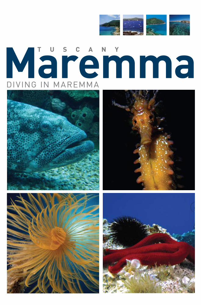
The entire area is to be visited and enjoyed, and the beauty of the seaside towns and views along the coastline are merely the start of that which can be admired underwater. Natural caves, crevices and relics: these are what scuba divers, under the supervision of experts, can discover in the surprising underwater environment, rich in interesting life forms: vast extents of red and yellow gorgonians are the hiding place for larger fish and for small shrimps, beautiful seahorses swim among branches of black coral, with elegant lobsters and amusing moon fish. These are only some of what can be seen in some of the more attractive underwater itinera-ries in the Maremma, where nature is still the main player and has always been the undoubted master in the area.
INTRODUCTION
5

D I V I N G I N M A R E M M A
3
2
1
PUNTA CAPEL ROSSO
SMALL CAVESIN CALA DELL’ALLUME
CALA CUPA
ISLAND OF GIGLIO
The Island of Giglio is the second largest in terms of area of the seven islands comprising the Tuscan Archipelago. Located opposite the Pro-montory of Monte Argentario, which is the only departure point for the ferries which provide daily connections, the island is almost entirely granite, from which its smooth and flat coastline is formed, alterna-ting with superb sandy bays, ensuring that most of the island is still wild and untouched.
In spite of the major tourist developments in recent years, the island has managed to maintain a good balanced between human activity and natural heritage, and the three inhabited centres, Giglio Porto, Giglio Campese and Giglio Castello, are capable of responding to tou-rist requirements while maintaining their traditions and a strong con-nection between the sea and land, which is more marked here than in any other part of the region.
6

7
ThE DIVE
WIND cONDITIONS Almost all winds
DIFFIcuLTyEasy to average
DEpTh ADVISED 30 metrescuRRENT
RareTypE OF SEAbED
Boulders
NotesImmersion suited to all, perfect
for initial experiences or regaining confidence after a long break.
Excellent protection from frequent adverse weather.
Easy to reach the deepest depths from the bay.
As already mentioned, the immersion starts in the calm waters of the bay. There is no current here, and there is protection from almost all wind, even when the sea is rough. The large grain sand on the sea bed immediately sinks if it is moved, without visibility being affected in any way. On leaving the bay, the more experienced divers will head towards the south, keeping the rocks on their right, as though they were headed for the port of Giglio.
Here, they will cross an area rich in wildlife, then following the granite rocks, which go increasingly deeper further into the itinerary. There are large flat slopes going down to the seabed, with compact rocks plou-ghed by long crevices. These crevices are the breeding ground for seve-ral species of sponge and pretty colonies of bryozoans (Sertella sp and Myriapora sp). The creatures that live there.The itinerary continues towards the port, keeping the rock face to the right and descending ever deeper. This is the most spectacular part of the dive: at a depth of between fifteen and twenty-five metres, there
cALA cupAIt would be fun to do a survey of Italian scuba divers and ask how many of them have done one of their first five dives in the calm waters of Cala Cupa.
It is a minute bay, with crystalline water with heavy white sand on the seabed. Squeezed between high granite rocks, Cala Cupa appears to have been placed there deliberately, at a depth of about three metres, as the ideal training ground for beginner divers to take their first practice after their course and learn to love this activity.
The immersions which start from Cala Cupa are ideal for all levels of experience.
1
BETwEEN THE PORT AND ARENELLA BEACH.
N 42°22’082’’ - E 010°55’048’’
7I S L A N D O F G I G L I O

I S L A N D O F G I G L I O
CALA CUPAThe dive
is an area of the seabed characterised by a multitude of huge round boulders balanced on top of each other. As always, the most intense colours are to be seen under the boulders, and fish and crustaceans seek refuge between them. The upper surfaces of the boulders are sometimes decorated by the corollas of beautiful spirals. One can go on an infinite number of dives in this area and never get bored; a different itinerary can be followed every time in the labyrinth of boulders descending to the seabed. Inside some of the openings, there are an infinite number of small scorpion fish, combers and wrasses which come and go from the clumps of posidonia spread among the boulders.
In the darkest recesses, the apogon are highlighted by their bright red colour, while a careful eye will notice the large numbers of prawns, red or yellow Ste-nopus, red Parapandalus and diaphanous Palaemon. There are sometimes lar-ge colonies of bryozoans on the rock faces, between the yellow colour of the Leptosamnie. There are beautiful yellow gorgonian (Funicella sp) deeper down, usually growing on the rocks which are less exposed to direct sunlight. This is the boundary between the rocks and the seabed.
The environment is light: the blue of the water reflects off the whiteness of the sand, which leads slowly to deeper waters. Further out to sea, it is not difficult to see the dark profiles of a series of rocks rising up from the seabed, beautiful iso-lated rocks rising from the sand, which are heavily colonised by large branches of red gorgonian, which prosper in the vicinity of each other. Shoals of sea perch swim around them: it appears that they want to highlight the profile of the rocks. In this area, the seabed is at a depth of between thirty-five and forty metres. The-re is one rock after another, roughly following the shape of the coastline.
Those further to the north, the first rocks one comes across if going directly along the border between sand and posidonia starting from the bay, are the smallest and shallowest. Continuing towards the port, the rocks become incre-asingly large and spectacular, often rising from seabed at depths of over forty metres. This area is obviously for more experienced divers.
8

RIDOSSOVenti da ovest a settentrione
DIFFIcOLTàImmersione in corrente, che
necessita di lunga pinneggiata. Difficoltà elevata.
pROFONDITà cONSIGLIATATra i 35 e i 40 metri.
TIpO DI FONDALECreste rocciose che escono
verso il largo
I S L A N D O F G I G L I O
2
Beyond the Gulf of Campese, heading towards the south, the granite structure typical of Giglio suddenly changes. The worn and rounded, smooth, polished and carved by the wind into their characteristic shape, give way to completely different rock formations, reminiscent of parts of the coast around Monte Argentario. The coastline becomes more ir-regular, the sea bed less precipitous; a long, shallow shelf extends out towards the open sea, favouring the expansion of large growths of Po-sidonia. The remains of an ancient pier and the strange and bold form of the old Campese light house seem to announce this change. The pier was that used by the boats arriving here to load the minerals extracted from some of the mines in this part of the island.
A couple of ancient tunnels are still visible a few metres from the sea in the small bay, surrounded by sheer, wild rocks, from where this iti-nerary begins. In the middle of the Cala dell’Allume bay, a large rock juts out from the sea, surrounded by smaller ones. The bay is protected from all winds, including the Mistral and Sirocco. It is characterised by a shallow seabed and is covered by a thick layer of Posidonia, as is almost the entire area.
The depth does not exceed fifteen metres, and what we are about to de-scribe is a very easy dive, with no risks or difficulties involved. The rocks in Cala dell’Allume are the perfect location for end of course dives or for beginners doing their first dives without the supervision of an instruc-tor. Independently of the difficulty involved, the location provides some spectacular scenery.
SMALL cAVES IN cALA DELL’ALLuME
WIND cONDITIONSMistral and sirocco
DIFFIcuLTyEasy
DEpTh ADVISED15 metrescuRRENT
NoneTypE OF SEAbED
Posidonia and small caves
OFF THE wEST COAST OF GIGLIO, SOUTH OF THE GULF OF CAMPESE.
N 42°21’038’’ - E 010°53’970’’
9

I S L A N D O F G I G L I O
SMALL CAVES IN CALA DELL’ALLUME
Let us drop anchor then, to the north of the largest of the rocks, taking care to not let the anchor get entangled in the Posidonia, but to bury itself in the sand and not disturb the plants. we will then swim along the layer of plants towards the rock, taking care as the layer of posidonia is an environment concealing countless surprises; sea horses and sea dragons live here. Small scorpion fish and starfish hide among the sea anemones, and large spirals often rise up at the edges of the plants. Areas where posidonia grows are often, wrongly, ignored by scuba divers. On reaching the rocks, it can be seen that the underwater area is much more widespread than it appears form the surface. Its form is similar to a volcano with a small part of its crater above the surface and the rest below.
Moving closer to the underwater rock faces, there is a small arch on the seabed, through which the inside of the “crater” can be reached. The environment is ra-ther scenic, being inside a vertical cut in the rock into which sunlight penetrates from above. Underwater photographers with wide-angle lenses could have a lot of fun here. Turning towards the right, and leaving the cut in the rock, one enters the “crater”. One can leave wither by swimming over the face or going through another short tunnel opposite. On the opposite side, there is another series of passages to be explored; there is no danger of getting lost or stuck, but a torch is indispensable for seeing the small Palaemon shrimps and the brilliant red Apogon, a small fish which usually preserves its eggs in its mouth, and also to illuminate the colours of the sponges and the so-called “mad coral” (these are actually bryozoans, although similar to precious coral, and go by the scientific name Myriapora truncata).
Leaving the tunnels and continuing round the large rock, swimming on a seabed where small shoals of red mullet will almost certainly be encountered, scouring the seabed with their whiskers, as will immobile and camouflaged polyps, small bream and large shoals of black damselfish. This dive is very easy and extremely pleasant.
ThE DIVENotesThe ideal location for a first
dive or for starting after a long gap.
Always carry a torch, which will be needed for explo-
ring inside the caves.
10

ThE DIVE
WIND cONDITIONSEasterly and northerly
DIFFIcuLTyThe presence of underwater current
requires strong swimming. High level of difficulty
DEpTh ADVISEDBetween 35 and 40 metres
cuRRENTStrong
TypE OF SEAbEDRocky crests going out to sea
Once the boat has been anchored, it is a good idea to have a clear pictu-re of what awaits underwater. The morphology that will be encountered, as already mentioned previously, is similar to that characterising the external part of the point. The dive will be along a smooth sea bed, slo-ping downwards to increasing depths, keeping the raised underwater outline of the point, which reaches the bottom in a vertical step, to the left. For some distance, the face which reaches the bottom starts from a shelf at a depth of about twenty metres.
Further out to sea, the rocks separate into series of parallel promon-tories. This morphology is very spectacular, and provides a series of crests and troughs which can be explored in quick succession, one after
NotesA dive suitable for everyone, perfect for first experience or to regain con-
fidence after a long break.
Excellent protection from very fre-quent adverse weather conditions.
Easy to reach the deepest seabeds from the bay.
I S L A N D O F G I G L I O
3 puNTA cApEL ROSSOThis itinerary is perhaps the most exciting of those proposed.The itinerary is long and varying, including wild seabeds going further and further from the coastline. This is the location most frequented by the island’s fish, and is certainly the one where encounters with large fish are most probable. Contrarily to the Fenaio, the northernmost tip of the island, Punta Capel Rosso, is subtle and extends decisively towards the south.
There is a smooth shelf extending at a depth of about twenty metres, which outlines the shape of the point underwater. This would seem to indicate that starting the dive form the eastern or western side would make no difference; in truth, there are a number of factors which make the eastern side the ideal starting point. Here, right under the lighthou-se, there is an obvious bay, which is small, but still able to provide good shelter for small boats, especially because it has a very firm bed.
THE SOUTHERNMOST PART OF GIGLIO, ON THE EASTERN SIDE UNDERNEATH THE LIGHTHOUSE.
N 42°19’034’’ - E 010°55’201’’
11

I S L A N D O F G I G L I O
PUNTA CAPEL ROSSOThe dive
another. Both sides of the rocky crests are beautiful, dominated by the richness and variety of the thick layers of gorgonians, which is present here until a depth of just over twenty metres.This is a wonderful spectacle: rocks covered in gorgonians and brilliant orange sponges rise up from the light sand seabed, surrounded by dense shoals of sea perch which are so thick that one cannot see much beyond them. Unfortunately, during the spring, there is a proliferation of algae in this stretch of sea, caused by its extreme exposure to sunlight, which for a time tend to cover everything in sight. Starting from the bay and keeping the main structure to the right, a depth of about thirty-five metres is reached, where the crests begin, which can either be followed peak to peak or along their profiles, reaching down to the sandy seabed. An immersion using a re-breather, enabling the entire structure to be followed from east to west, then returning to the point of departure, is unforget-table. This itinerary is too long and difficult to use ordinary open circuit automa-tic breathing equipment.If using ordinary cylinders, the seabed around Punta Capel Rosso will have to be explored in several segments. However, care must be taken as the unknown factor in this area is the current, which is frequently strong in this area and may force changes in itinerary to be made once the seabed is reached. Although the series of crests and troughs provides excellent protection, when the current is strong, the return to base will have to follow the same path as that going out, thus missing out on the advantage of the reduction of depth when returning.
what about fish? where can they be encountered? when the current allows, the return journey could provide some extraordinary encounters with dentex, amberjack and substantial shoals of barracuda, tuna and mackerel often being found in the proximity of the shelf, in the water between it and the surface. while the sight of barracudas swimming over your head is spectacular, do not forget to take care as to where you are: a shelf at a depth of twenty metres can easily cause the loss of orientation, and surfacing in open water at Punta Capel Rosso is very dangerous, because of the danger of being swept away by the current and the risk of being hit by a boat.
which is the best itinerary to follow? The safest is that following the outermost part of the initial protuberances and returning from there, if possible not as deep as previously. Alternatively, if there is no current, one could reach a certain point by following the crests rising form the sandy seabed and returning in one of the troughs, reaching the shelf from there. A compass is useful for indicating the coastline, going in a roughly northern direction, which is the best way to admire the dentex and amberjacks.
12

D I V I N G I N M A R E M M A
2 THE ARCHES
1 THE wRECk OF THE NASIMAlthough it is now a protected nature reserve in the Tuscan Archipe-lago Natural Park, in ancient times, the island of Giannutri, Artemisia to the Greeks and Dianum to the Romans, was already a well known location, as shown by the ruins of large settlements.
There are only two points of entry, Cala Maestra and Cala Spalmatoio, but Giannutri still attracts tourists by its natural, attractive and wild environment. Thanks to it mild climate, the Mediterranean forest at-tracts species which are not natural to the area, such as tropical plants and wild orchids, while for underwater enthusiasts, its high and sheer coastline provides attractive seabeds and mysterious wrecks.
ThE ISLAND OF GIANNuTRI
13

WIND cONDITIONSEastern winds
DIFFIcuLTyHigh
DEpTh ADVISEDThe seabed is at a depth of 60
metres, the upper side at 45 metrescuRRENT
NoneTypE OF SEAbED
wreck
ThE DIVE
It is advisable to do this dive equipped with cylinders containing a mix-ture of trimix, as a mixture consisting of oxygen, helium and nitrogen is ideal at these depths. This mixture actually contains approximately 20% oxygen, while a significant amount of helium replaces the same amount of nitrogen, the gas which causes undesired loss of lucidity, and, if new theories are to be believed, more difficult to manage in decompression terms than very light helium gas. The Nasim is located on a flat seabed at a depth of approximately sixty metres, not very far from the coast-line. This is not a prohibitive depth, but is certainly not easy to reach, especially in this case, where one will be swimming in the shadow of the boat’s hull, in a rather dark and depressing environment which could enhance the narcotic effects of nitrogen.
The Nasim is keeled over on its left side, with the bridge pointing to-wards the open sea and greater depths where the light decreases. The significant size of the ship is also a negative factor for scuba divers, as they imply strong strokes while swimming, and we all know that tired-ness and hypercapnia are two of the main factors which increase the narcotic effects of nitrogen. This dive must not be taken lightly: it is not particularly difficult, but it should not be underestimated, and it is not a
T H E I S L A N D O F G I A N N U T R I
NotesA difficult dive, the use of a light
trimix mixture is advisable.
The image of the gashed hull on the seabed is spectacular.
Note: the dimensions of the ship require a strong swim. Dividing the
itinerary into two separate dives should be considered.
1 ThE WREck OF ThE NASIMThe Nasim is the larger of the two boats which sunk near the island, and also the deepest and most spectacular, and certainly the most difficult to reach.It was transporting cars when it hit the rocks off Punta Pennella during a night when the sea was calm, ripping a large hole in its aft section. witnesses say that the crew attempted to reach the small bay at Cala Maestra to get to the beach and save themselves from drowning.
However, the ship keeled over and sank, spreading part of its cargo, cars, over the sandy seabed. The Nasim is known amongst scuba divers as the “car wreck”. It is a well known and admired wreck, much visited in all seasons, but is at the extreme limits of scuba diving in sporting terms.
BEyOND THE SOUTHERN POINT OF CALA MAESTRA, BETwEEN IT AND PUNTA PENNELLO.
N 42°15’316’’ - E 011°05’491’’
14

THE wRECk OF THE NASIMThe dive
dive that should be done by those who do not have any experience at depths of more than forty metres. Identifying the Nasim is not difficult; looking at Cala Maestra from the sea, it is a few metres away from an obvious triangular fracture in the rocks. To rocks of Punta Pennello are to the right, while to the left, the point of the bay should be aligned with the stairway rising up form the beach and the external point of the Granduca tavern should be aligned with the inner corner of the tower above it. Generally speaking, there is often a fixed anchorage point above the Nasim, which is of great help in this sort of immersion.
Descending towards the wreck, the water is generally very clear, as is the case around Giannutri. In good conditions of good visibility, the side of the ship, which rises to a depth of almost forty-five metres, will be very easily identifiable during the descent, and is obvious from the quantity of anthias concentrated around it. Recently, the uppermost structures of the ship, corresponding to what was its starboard side, have been completely covered by transparent tunicates. This is where a swim along the upper side, whe-re there is still a lot of light and large bream swim in numbers, can be an excellent alternative to diving down to the sediment on the seabed. However, care must be taken: in planning a dive of this sort, one side or the other must be chosen, or ballast and instruments must be perfectly controlled so as to not exceed the depth expected to be reached during the dive, while swimming directly over the bridge of the boat. Let us imagine a complete exploration of the wreck. Descending, once the vessel is in sight, one can leave the forward section and go towards Punta Pennello, going towards the stern in order to see the propellers, before exploring the bridge, which is quite large, providing a number on entrance points, ne-arly all of which actually have no exit, with hoists, cranes and beams all covered in underwater plants.
The wreck will almost certainly conceal large scorpion fish, shrimps of all sorts and rays will be found hi-ding in the darkest recesses, with minute lobsters. There are also beautiful large lobsters living between the seabed and the side of the vessel. It is a very impressive experience diving under this gigantic mass of steel, but also not advisable, as the lobsters need a peaceful environment, otherwise we would not be able to occasionally see them outside their hiding places. Going further long the wreck towards the bow, the first cars are encountered scattered on the sand. It is curious to note that even this site has not been spared from the vandalism of certain scuba divers on the cars, which in this area are to be found more or less everywhere. In theory, following the line of cars should bring one up the shallow sandy slop to the coastal shelf, leaving the boat behind. The limit between sand and rock face is about forty-five metres, and surfacing from here is fairly quick, involving smooth decompression in several stages. There is ano-ther car at a depth of slightly more than thirty metres, but this has now been completely destroyed.
Apart from this, our advice, once the bow has been reached, is to come back along the bridge, following the side until reaching the fixed anchorage to ensure a safer surfacing, avoiding getting lost on the sea-bed and with the certainty of having an emergency cylinder available from our boat. Descend along the coastline, past the car at a depth of thirty-three metres, and going deeper without actually reaching the wreck could be the basis of a different itinerary for another time.
T H E I S L A N D O F G I A N N U T R I 15

T H E I S L A N D O F G I A N N U T R I
WIND cONDITIONSEasterly and north-easterly winds
DIFFIcuLTyEasy
DEpTh ADVISED15 metrescuRRENT
NoneTypE OF SEAbED
Rocky faces and rockyand posidonia seabed
The route goes towards Cala Ischiaiola, and then beyond, in a slight-ly southerly direction to the wreck of the Anna Bianca. The anchorage point is right opposite an obvious rock formation jutting out of the wa-ter, near a large cavity in the rocks. This rock is only a few metres away from a rocky outlet.Right here, between the rock and the outlet, just below the surface of the water, a small rocky archway opens up, leading to the seabed at a depth of about thirteen metres. Care must be taken when going through this arch: the rocks forming it are colonised by a wide range of animals, and it is always nice to stop and admire them for a short time. Plant coverage is almost total, and includes Parazoanthus, a large amount of
ThE DIVENotesEasy dive in shallow waters.
A small torch is useful.
Access to a natural swimming pool not visible from land.
2 ThE ARchESThis a very easy dive, as well as pleasant and entertaining, and is ideal after a difficult dive, such as those to the wrecks of the Anna Bianca or Nasim. This is a very entertaining dive, characterised by the morphology of the seabed, which is very spectacular.As its name suggests, the dive involves swimming through a series of rocky arches and small caves, on a seabed which although only a few metres deep is very interesting. The dive reaches a depth of no more than fourteen metres, although it is certainly possible to go down dee-per and search for the lobsters and rays which hide on the seabed un-derneath the rocks.
However, this neither the itinerary nor the aim of the itineraries in the-se pages, which are dedicated to those who want a relaxing swim on a shallow seabed.
INSIDE THE BAy AT CALA ISCHIAIOLA.
N 42°14’934’’ - E 011°05’762’’
16

THE ARCHESThe dive
yellow, encrusting sponges and various types of worm, such as red tube worms and spirographs. The darkest recesses should be examined carefully; it is easy to see examples of cowry, one of the most beautiful shells seen in the Mediter-ranean, although its dimensions are nothing extraordinary. These creatures are most often encountered at night. Exiting the archway, there is a shallow seabed with the sheer rock face in front. Most probably, a large and elegant shoal of black damselfish. keeping the rock face to the left, a shallow seabed is reached, where small moray eels and octopuses can be seen.
“Sea hares” are very common in these waters, and are known scientifically by the name Aplysia. These are gastropod molluscs without shells, and are able to move for shirt distances by swimming in open water. Fishing frogs and electric rays will also probably be encountered here. After a few metres, a small cave is reached, which opens out of the rock face and is inhabited by combers, apogon and several types of small shrimp. On the outlet, there is another opening, which it is possible to swim into. There is no risk or danger in this, as the exit can be seen immediately to the right.
There is also a lot be seen in this opening.Obviously, as is always the case, it should be remembered that the effects of bubbles on the hidden faces of animals can be devastating in the long term, and as short a time as possible should be spent inside. Going towards the right, and exiting through a short tunnel, a beautiful and rich mat of posidonia is reached. In this area, polyps, shrimps and small fish can be found hiding in the mat, pro-tected by the stems. There are also incredibly camouflaged fish, such as the pipe fish, leafy sea dragons and seahorses; these creatures all belong to the same group, the syngnathidae. From the mat of posidonia, keeping the rock face to the right, it is easy to return to the first archway and the boat.
T H E I S L A N D O F G I A N N U T R I 17

18
The promontory of Monte Argentario is naturally linked to land by the action of underwater current, through two stretches of land, the Tom-boli della Feniglia and della Giannella, which are now two magnificent beaches enclosing within them the slightly salty waters of the Laguna di Orbetello, which is rich in fish and partly a protected wwF oasis.
The land around the promontory is prevalently hilly and in some pla-ces, terraces surrounded by dry faces, facing out over some breathta-king scenery, are evidence of man’s activities being in perfect harmony with their environmental context.
The only inhabited centres in the area are Porto S. Stefano and Por-to Ercole, which were founded as fishing villages and are now tourist ports and have been renowned seaside holiday locations for the rich and famous since the mid-1960s.
2
3
1
SCOGLIO DELL’ ARGENTAROLA
ISLET OF PORTO ERCOLE
CALA DEI SANTI
MONTE ARGENTARIO
D I V I N G I N M A R E M M A

ThE DIVE
WIND cONDITIONSwesterly winds
DIFFIcuLTyEasy and quite difficult itineraries
to choose fromDEpTh ADVISED
35 metrescuRRENT
Probable on the extremityof the outlet
TypE OF SEAbEDCollapsed alternating with vertical
rock precipices
NotesSuitable for experienced divers and
beginners.
Care must be taken in termsof orientation.
Rich in benthic life forms 30 metres and deeper.
M O N T E A R G E N T A R I O
In truth, this dive is more commonly referred to by another name, for the reasons previously illustrated: it is better to have a safe anchorage in the bay of Cala dei Santi and then swim out to sea, following the rock face, rather than anchoring above the deep seabeds around the outlet and risk losing orientation in water that is often dirty, unfortunately. This would also deprive divers of the chance to choose an itinerary ba-sed on their level of experience.
Leaving from Porto Ercole and going along the coastline, the outside extremity of the islet is reached, and from there, Punta dell’Avoltore is immediately opposite. This is the buttress which encloses the wide gulf which is to be crossed.
An ancient tower faces out to sea, and there is a cave opening a few metres above sea level. This cave is the unmistakable sign indicating the anchorage, in a bay with a rocky seabed and excellent anchoring qualities. It is here on this seabed, which is easy to swim in an rich in
cALA DEI SANTI1
One of the classic dives in the Argentario area.A beautiful and varied itinerary on a seabed rich in wildlife, providing in-terest for experienced scuba divers and beginners. The itinerary starts in a bay which is ideal for end of course trips, as a school which orga-nises trips in the open sea can take the open group out into the bay and the more advanced divers along the rock face. This dive was once known as the Punta dell’Avoltore. The main itinerary goes along the submerged buttresses of this spectacular limestone outlet, one of the most beauti-ful places in the Argentario area from a scuba diving viewpoint.PUNTA DELL’AVOLTORE, SOUTH OF THE
PROMONTORy.
N 42°21’909’’- E 011°11’377’’
19

CALA DEI SANTIThe dive
M O N T E A R G E N T A R I O
wildlife, where instructors take their students out on their first dives when they start courses. There are beautiful rock beds providing homes for small scor-pion fish, lobsters (Palinurus sp) and polyps (Octopus sp). The recesses betwe-en rocks and sand are inhabited by apogon, Serranidae and all those creatures which basically live in the sea at a depth of a few metres. There are branches of yellow gorgonians dotted around on the rocks.
The more experienced scuba divers can swim on the surface towards the outlet, which is where the dive starts. During the descent, the face should always on the right. The abundance of small bream escaping towards the open sea is immedia-tely noticeable on arrival. These fish often hide among the rich colonies of yellow and white gorgonians (Eunicella sp) on the rocks at depths between fifteen and twenty metres. Continuing the descent, the first branches of Paramuricea are soon encountered. One does not need to descend further than thirty metres be-fore being surrounded by a forest of red gorgonians. This is the main part of the dive; unfortunately, the water is often too murky to provide much of an overview of the seabed, which means that it is not easy to see that the submerged base of one of the two southernmost outlets of the Argentario promontory is in the shape of a cat’s paw. Beyond the rocky face, the muddy seabed often encounte-red at depths between forty and forty-five metres, splits into a sequence of rocky lines (similar to the toes on a cat’s paw) stretching slightly out to sea. Obviously, circumnavigating the outline of this rock formation provides many alternatives for scuba divers.
This is an area extremely rich in life forms in the benthic zone. In addition to the red gorgonians, there are small branches of coral (Corallium rubrum) and be-autiful branches of Lophogorgia, a gorgonian with very complex branches typical of deep or muddy seabeds. There is also an abundance of beautiful sponges and large examples of Spongia officinalis, famous for being used as a bathroom sponge.
There is also an abundance of small perches and large scorpion fish(Scopaena sp) on the seabed, and dense shoals of anthias swim around the gorgonians. Obviously, a dive of this sort, which involves swimming along a section of seabed in often limited visibility, requires rigorous planning, especially as regards the return leg. The amount of air required to reach the starting point must always be taken into consideration, as it would be a serious mistake to surface in open water in an area with a lot of traffic and far away from the anchored vessel.
20

M O N T E A R G E N T A R I O
The itinerary travels along the face, which slopes down to a depth of about fifteen metres, and then gets steeper, reaching a depth of about twenty-seven metres. The ideal anchorage point for the best itinerary is above a seabed of about eighteen metres in depth, on the southeast side of the islet, about fifty metres from the southern extremity. Having dropped anchor, the flat seabed at a depth of about eighteen metres is ideal for setting equipment and taking a few minutes to find the best ballast.
The seabed here has rocks and posidonia scattered about. when ready, and staying at more or less the same depth, the itinerary goes towards the outlet, until reaching a rocky face to the left, which juts slightly out
ThE DIVENotesA dive suited to all levels
of experience.
A pleasant swim along a submerged rock face.
The dive closest to Porto Ercole.
WIND cONDITIONSProtected from northerly winds
DIFFIcuLTySuitable for divers with any level of
experience DEpTh ADVISED
20 metrescuRRENT
LightTypE OF SEAbED
Rock face
Exiting Porto Ercole, or the bay at Cala Galera, and going towards the high and rocky coastline of the Argentario promontory, the Islet of Porto Ercole is a very obvious point, as well as the obvious peak of the Spanish rock.
The islet is elongated in shape, with an orientation of roughly northwest to southeast, with a characteristic profile of two obvious peaks, similar to the humps of a dromedary. The most interesting part as far as diving is concerned is that facing the open sea. The dive itself is reasonably easy, suitable for scuba divers with any level of experience. However, in spite of this, it still offers a spectacle of biocoenosis which can only be seen elsewhere at mush greater depths. This spectacle is most no-ticeable in the rich colonies of red coral and the large numbers of small lobsters hiding in the recesses between the coral and gorgonians, at a depth of less than thirty metres. This is a very beautiful dive, although it is often overlooked and in some ways snubbed by divers who come to this area.
ISLET OF pORTO ERcOLE2
OPPOSITE THE ROCCA, ONE OF THE FORTS IN PORTO ERCOLE, ON THE SOUTHEAST SIDE OF THE PROMON-TORy.
N 42°22’772’’ - E 011°12’671’’
21

M O N T E A R G E N T A R I O
ISLET OF PORTO ERCOLEThe dive
to sea. The rock is cracked, and there are a series of crevices, recesses and ceilings colonised by benthic creatures. The yellow of the spectacular array of sponges and the small colonies of Clathrina stuck to the underside of the rocks are spectacular. There are also sponges of other colours, such as the red and blue encrusting sponges and the pink Oscarella and Haliclona. There are also numerous examples of nudibranches here, including the yellow Hipselodoris and the characteristic “sea cow”, which is also a nudibranch, known by the scientific name of Discodoris.
Continuing on with the face on the left, going towards the extremity of the islet, the rocks go down ever deeper, reaching a muddy seabed at a depth of about twenty-seven metres. The entire itinerary, starting at a depth of between fifteen and eighteen metres, goes alongside a rock face colonised by abundant colonies of red and yellow gorgonians.
Observing carefully between the branches, conger eels, moray eels and lobsters will often be seen outside their burrows. The itinerary following the rock face could easily continue for longer, taking in the submerged rock peaks for another few hundred metres. However, this would require frequent instrument checks and deciding whether to turn back consumption and data provided by the com-puter as regards decompression indicate that the depth we are at should be progressively reduced and that we should return to the starting point. During the return leg, a depth of about fifteen metres should be maintained. There is a small cave with a muddy bed from which several Cerianthus emerge, which is inhabited by a multitude of small red Parapandalus shrimps, which always escape from torchlight.
A bit further on is another cave with a base at about nine metres depth and the top at about three. Both caves have faces covered in luxuriant colonies of Para-zoanthus and sponges. A few metres further on, continuing the return leg with the face to the right, the anchorage point will be reached. Once in the area, the seabed at a depth of about ten metres should be carefully observed: some small groupers will probably be seen hiding in the recesses.
22

M O N T E A R G E N T A R I O
WIND cONDITIONSFrom the north or south according
to the side chosen for anchorageDIFFIcuLTy
Average/easyDEpTh ADVISED
30 metrescuRRENT
Only at the extremityTypE OF SEAbED
Rock face
ThE DIVENotesSplendid dive for divers with any
level of experience.
Different itineraries are possible.
A beautiful dive at any depth.
The anchorage point for the boat is above a shallow seabed about hal-fway down the length of the rock, where there is a steep rock face, which is sheer in some points. The seabed below is at an average depth of about fifteen metres, and the seabed is rocky and firm.Once anchored, the boat will be over a seabed similar to that described for the opposite side: numerous white gorgonians are interspersed by small clumps of posidonia and large round rocks.Going south from this point, a seabed is reached at a depth of between
3 ScOGLIO DELL’ ARGENTAROLAA long way from the coastline, isolated in open sea, the Scoglio dell’Ar-gentarola, which is shaped like the keel of a capsized boat, is certainly one of the major locations for scuba diving around the Argentario pro-montory. Dives in these waters are easy for all, expert scuba divers and beginners, and are generally protected from the current, making this one of the preferred locations for scuba divers coming to the area. There are several itineraries possible, along the submerged rock faces.A definite distinction must be made between the morphology, and con-sequently the wildlife, on the two opposite sides of the rock.
As has already been mentioned, the Scoglio dell’Argentarola is charac-terised by a rather elongated form, reminiscent of the keel of a capsized boat. It is this particular form which gives the demarcation between the exposed north-western side, pointing towards Porto S. Stefano, and the side facing south, directly opposite the island of Giannutri.The northern side slopes down gently to increasing depths; the seabed is mainly colonised by abundant white (Eunicella stricta) and yellow (Eu-nicella Cavolinii) gorgonians, which get more numerous deeper down.However, the opposite side is decidedly more sheer, especially in the proximity of the extremity. This is obviously the side chosen for our di-ves, unless the southerly wind forces us to seek shelter on the opposite side.
BEyOND THE SOUTHERN POINT OF CALA GRANDE, ADRIFT OF PUNTA DI CALA MORESCA.
N 42°25’096’’ - E 011°04’808’’
23
SCOGLIO DELL’ ARGENTAROLAThe dive
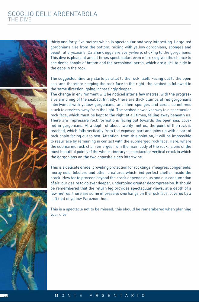
thirty and forty-five metres which is spectacular and very interesting. Large red gorgonians rise from the bottom, mixing with yellow gorgonians, sponges and beautiful bryozoans. Catshark eggs are everywhere, sticking to the gorgonians. This dive is pleasant and at times spectacular, even more so given the chance to see dense shoals of bream and the occasional perch, which are quick to hide in the gaps in the rock.
The suggested itinerary starts parallel to the rock itself. Facing out to the open sea, and therefore keeping the rock face to the right, the seabed is followed in the same direction, going increasingly deeper. The change in environment will be noticed after a few metres, with the progres-sive enriching of the seabed. Initially, there are thick clumps of red gorgonians intertwined with yellow gorgonians, and then sponges and coral, sometimes stuck to crevices away from the light. The seabed now gives way to a spectacular rock face, which must be kept to the right at all times, falling away beneath us. There are impressive rock formations facing out towards the open sea, cove-red in gorgonians. At a depth of about twenty metres, the point of the rock is reached, which falls vertically from the exposed part and joins up with a sort of rock chain facing out to sea. Attention: from this point on, it will be impossible to resurface by remaining in contact with the submerged rock face. Here, where the submarine rock chain emerges from the main body of the rock, is one of the most beautiful points of the whole itinerary: a spectacular vertical crack in which the gorgonians on the two opposite sides intertwine.
This is a delicate divide, providing protection for rocklings, meagres, conger eels, moray eels, lobsters and other creatures which find perfect shelter inside the crack. How far to proceed beyond the crack depends on us and our consumption of air, our desire to go ever deeper, undergoing greater decompression. It should be remembered that the return leg provides spectacular views: at a depth of a few metres, there are some impressive overhangs on the rock face, covered by a soft mat of yellow Parazoanthus.
This is a spectacle not to be missed; this should be remembered when planning your dive.
M O N T E A R G E N T A R I O24

D I V I N G I N M A R E M M A
SECCA DELLO ZI’PAOLO
FORMICA GRANDE
2
1
FORMIchE DI GROSSETO
As their name suggests (formica is the Italian word for ant), these islands are the smallest in the Tuscan Archipelago. These are not ac-tually islands, but rather large rocks, three of them to be precise, lo-cated opposite the Maremma Regional Natural Park, emerging from waters that are already deep.
Formica Grande, Formica di Mezzo and Formichino (literally big ant, middle ant and small ant) are natural paradises for lovers of the envi-ronment and, because of their location on shipping routes, have been the scene of numerous accidents in the past, which have left behind a richness of archaeological findings on the seabeds, in addition to their natural beauty.
25

F O R M I C H E D I G R O S S E T O
FORMIcA GRANDE
WIND cONDITIONSEasterly winds
DIFFIcuLTyHigh
DEpTh ADVISED50 metresCURRENT
Often strongTypE OF SEAbED
Rock belt
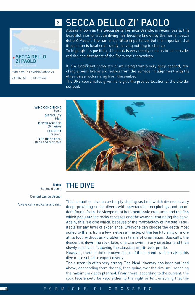
The Formiche di Grosseto are nothing more than three rocks, aligned approximately from northwest to southeast, emerging from the sea a short distance off the coast at Parco dell’Uccellina. They are located about eleven miles south of the port of Castiglione della Pescaia and ten miles north of the island of Giglio. Coming from the north, Formica Grande is reached first, followed by Formica di Mezzo and then Formi-chino.Of a mainly limestone nature, they face out over seabeds which over a distance of a few tens of metres reach a depth of one hundred metres. It is because of their exposed position in the middle of some very common shipping routes in this part of the Tyrrhenian that the Formiche were the scene of numerous accidents in ancient times.There are therefore a lot of well preserved archaeological artifacts, which are unfortunately in the deepest areas. Despite their almost ne-gligible size, the Formiche provide divers with a wide variety of immer-sion points, suited to divers with any level of experience, as there will nearly always be long vertical rock faces or quite precipitous seabeds, enabling the most suitable depth to be reached easily. There are itine-raries which are complex and difficult from an orientation viewpoint, or merely relaxing swims alongside the reassuring rock face. However, it should always be kept in mind that the Formiche are notorious among scuba divers because of the presence of currents which can be very strong at times. These currents are one of the reasons for the richness of the wildlife present, but can also be difficult for whoever dares to confront them incautiously. Care must always be taken and this element must always be borne in mind before planning any dives.
1
ON THE EASTERN SIDE OF THE FOR-MICA GRANDE, IN THE PROxIMITy OF TwO LARGE IRON MARkERS.
N 42°34’577’’ - E 010°52’825’’
26

F O R M I C H E D I G R O S S E T O
FORMICA GRANDE
This itinerary is based around the seabed surrounding Formica Grande. The lighthouse standing over it and its dimensions make the identification of the islet extremely easy. The side to be explored is the one facing out to sea, the north-western part of the islet, reached by going round the lighthouse and approaching the west coast. Two iron markers on the rock face provide an indication of the anchorage point: by placing the vessel straight between them, and approaching the rocks, a shallow and flat seabed is easily visible through the clear water.
This is the anchorage point. Once in the water, it is immediately obvious that the surroundings are like a huge amphitheatre. As already mentioned, the seabed slopes down slowly, with a large surface area visible at depths of between six and fifteen metres. This is the area where beginners will stop. There are abun-dant white gorgonians (Eunicella stricta) and a multitude of small fish among the large algae covered rocks. In this area, leerfish, mackerel and other pelagic fish are commonly seen, especially in the spring and autumn.
The more expert divers will continue to descend, going further out to sea, until reaching a sort of cone shape which makes a spectacular rock face at a depth of about thirty-four metres. The current is the major factor in deciding which direction to take from here. The rock face is beautiful whether seen swimming towards the north or south. The advantage of going south is that the belt of rocks goes further towards the islet in this direction, providing the possibility of going back to more shallow waters without retracing the route taken along the rock face and resurfacing from the deep slope followed during the descent. The rock face should preferably be on our left while swimming here. The seabed drops away beneath use, but we should not be tempted by these depths; if more care is taken, it will immediately be obvious that the first five or six metres beyond the belt are the richest, with an abundance of yellow sponges and gorgonians. The rock face is jagged, indented by the deep cracks which emphasise the structure of this sheer wall.
There are often an incredible number of lobsters at this point, rarely of signifi-cant dimensions, but often in great abundance. Deeper down, the rock face is no longer sheer but vertical, as are the cracks across it, which are often very deep. It is here, where the rock is most cracked that most of the red gorgonians jutting out to sea are grouped. The itinerary continues, beautiful and spectacular, on a seabed rich in plant and animal life. As already mentioned, there are two pos-sible return routes; the first means returning until the gap in the belt and sur-facing from there, while the alternative is to swim further out, until it is obvious that the belt itself gets very close to the submerged sides of the islet.
ThE DIVENotesVarious itineraries, for all
levels of experience.
Beware of the current.
A signalling device must be carried at all times.
27
NotesSplendid bank.
Current can be strong.
Always carry indicator and mill.This is another dive on a sharply sloping seabed, which descends very deep, providing scuba divers with spectacular morphology and abun-dant fauna, from the viewpoint of both benthonic creatures and the fish which populate the rocky recesses and the water surrounding the bank. Again, this is a dive which, because of the morphology of the site, is su-itable for any level of experience. Everyone can choose the depth most suited to them, from a few metres at the top of the bank to sixty or more at its foot, without any problems in terms of orientation. Basically, the descent is down the rock face, one can swim in any direction and then slowly resurface, following the classical multi-level profile.However, there is the unknown factor of the current, which makes this dive more suited to expert divers.The current is often very strong. The ideal itinerary has been outlined above; descending from the top, then going over the rim until reaching the maximum depth planned. From there, according to the current, the rock face should be kept either to the right or left, ensuring that the
ThE DIVE
WIND cONDITIONSSome
DIFFIcuLTyHigh
DEpTh ADVISED50 metrescuRRENT
FrequentTypE OF SEAbED
Bank and rock face
2 SEccA DELLO ZI’ pAOLOAlways known as the Secca della Formica Grande, in recent years, this beautiful site for scuba diving has become known by the name “Secca dello Zì Paolo”. The name is of little importance, but it is important that its position is localised exactly, leaving nothing to chance.To highlight its position, this bank is very nearly such as to be conside-red the northernmost of the Formiche themselves.
It is a significant rocky structure rising from a very deep seabed, rea-ching a point five or six metres from the surface, in alignment with the other three rocks rising from the seabed.The GPS coordinates given here give the precise location of the site de-scribed.
NORTH OF THE FORMICA GRANDE.
N 42°34’856’’ - E 010°52’493’’
F O R M I C H E D I G R O S S E T O28

29
SECCA DELLO ZI’ PAOLO The dive
depth is decreased progressively in order to optimise safety times. In truth, once the rock face is reached, it can be seen that it is very articulated and complicated by the presence of numerous outlets pointing out to sea which provide protection from the current. These rocky outlets are the focal points of the dive.
In these more jutting areas of the bank, the effect of the current is felt more in-tensely, ensuring that most of the nutrition is to be found here, which in turn me-ans that there is a great variety of benthonic creatures to be seen. Briefly, these imposing structures are those mainly colonised by forests of gorgonians, spon-ges, cnidaria, such as Leptosamnie and Parazoanthus, and bryozoans. This is where the most vital and spectacular ecosystems on the bank are to be found.
If a choice were to be made, we would advise, if the current allows, that the ea-stern side of the bank should be explored, as it is more sheer and rich in life than the western side. A large round rock on the rim of the bank signals the starting point for the dive. Swimming on the surface, the top can be seen, and our objecti-ve can be reached by heading towards the north. From there, the descent follows one of the numerous channels which open between the two crests, as described above. Once inside the channel, the planned depth can be reached, and the exact strength of the current can be measured from there, making sure one is protec-ted. It should be remembered that the current on the surface is not going to be the same as that underwater.
Once the desired depth has been reached and the situation is calm, it is advi-sable to swim with the rock face to the right, thereby exploring the eastern side and heading southwards. The depth will slowly be reduced. If the sight of the red gorgonians, lobsters and beautiful red and yellow crinoids attracts our atten-tion at depths of between thirty and fifty metres, shoals of dentex, bream and barracuda can be seen at lesser depths. These encounters alone make this dive spectacular, and are very common in these waters.
One last piece of advice: when the current is strong, one may be lucky enough to be able to follow an itinerary on the windward side of the bank. In this case, it must be remembered that at the last decompression point there will be no rock face to provide protection and no possibility of standing on the seabed. This element must be considered when planning the dive, so that we are not decom-pressing for several minutes at a depth of three minutes and dragged away by the current.
F O R M I C H E D I G R O S S E T O 29

USEFUL INFORMATION
LOcAL cOuNcILTel. +39 0564 806064
MEDIcAL GuARDS Giglio Campese Tel. +39 0564 804177Giglio Castello Tel. +39 0564 806068
pORT AuThORITy Tel. +39 0564 809480
LOcAL pOLIcETel. +39 0564 809232
U s e f u l n u m b e r s
U s e f u l n u m b e r s
S h i p p i n g C o m p a n i e s
cOAST GuARD Tel. 1530
cARAbINIERI Tel. 112
FIRE bRIGADE Tel. 115
MEDIcAL FIRST AIDTel. 118
cIVIL pROTEcTIONTel. 0564 20000
Hyperbaric Chamber OSpEDALE MISERIcORDIAVia Senese, 161 - Grosseto - Switchboard: + 39 0564 485111 - www.usl9.grosseto.it
TO.RE.MARPorto S. Stefano Tel. +39 0564 810803Fax +39 0564 818455 Giglio Porto Telefax +39 0564 809349www.toremar.it [email protected]
MAREGIGLIOPorto S. Stefano Tel. +39 0564 812920Fax +39 0564 811160 Giglio Porto Tel. +39 0564 809309Fax +39 0564 809469www.maregiglio.it [email protected]
E M E R G E N C I E S
I S L A N D S O F G I G L I O A N D G I A N N U T R I
LOcAL cOuNcILTel. +39 0564 811911
MEDIcAL GuARDS Tel.118
pORT AuThORITy Tel. +39 0564 812529
LOcAL pOLIcETel. +39 0564 812520
M O N T E A R G E N T A R I O
30
For a complete list of diving centres with scuba guides,see the website www.lamaremma.info
under the page leisure/sport and fun.

All rights reserved © Copyright 2009 APT MAREMMAPictures: Cesare Moroni, Giulio Soffritti, Archive APTText: APT, Roberto RinaldiTranslated by: ARA CongressiPrinted by: Grafiche Effesei (gr)Layout/Design by: 2Bcom
AGENZIA PER IL TURISMO DELLA MAREMMA MAREMMA TOURISM BOARD
Viale Monterosa, 206 - 58100 Grosseto - ItalyTel. +39 0564 462611 - Fax +39 0564 454606
www.lamaremma.info - [email protected]
ed. 2010

AGENZIA PER IL TURISMO DELLA MAREMMA MAREMMA TOURISM BOARD
Viale Monterosa, 206 - 58100 Grosseto - ItalyTel. +39 0564 462611 - Fax +39 0564 454606
www.lamaremma.info - [email protected]