Maps of America the Beautiful - Notgrass History · create your historical atlas, you will make a...
19
Maps of America the Beautiful A Student-Created Historical Atlas of the United States Bethany Poore
Transcript of Maps of America the Beautiful - Notgrass History · create your historical atlas, you will make a...

Maps ofAmerica the BeautifulA Student-Created Historical Atlas of the United States
Bethany Poore

Maps of America the BeautifulA Student-Created Historical Atlas of the United States
by Bethany Poore
ISBN 978-1-60999-013-8
This work contains original maps drawn for this publication by Bethany Poore.
Copyright © 2011 Notgrass Company. All rights reserved.Published in the United States of America.
No part of this material may be reproduced without permission from the publisher.You may not photocopy this book. If you need additional copies for children in your family
or for students in your group or classroom, contact Notgrass Company to order them.
Printed in the United States of America.
Notgrass Company975 Roaring River Rd.Gainesboro, TN 38562
1-800-211-8793www.notgrass.com

Maps of America the Beautiful was designed to help you learn about and remember places youread about in the lessons of America the Beautiful. As you complete the assignments in Maps ofAmerica the Beautiful, you are creating your own historical atlas of the United States. It will beuseful in this present study and as you study American history and geography in the future. Doyour best and neatest work as you color and identify places in this map book. As you carefullycreate your historical atlas, you will make a beautiful and useful book of which you can be proud.
Many lessons in America the Beautiful have a corresponding map in Maps of America theBeautiful. When there is a corresponding map, the map number will be listed in the heading ofthe lesson. Turn to page 2 in America the Beautiful. Notice that the heading for Lesson 1 looks likethis:
Before you read Lesson 1, turn to Map 1 in this map book. Refer to Map 1 while you read thelesson.
A list of activities follows Lesson 1. One of these activities is the map assignment for Lesson1. Look at the assignments on the page after this page in Maps of America the Beautiful. There youwill find instructions to follow to complete Map 1. Complete the assignments in the order theyare given.
Some maps are completed on one day, while others are completed slowly over the course ofthe entire year. Turn to Map 2 to see an example of this. Notice that there are many instructionsfor Map 2. Look at the assignment for Lesson 13. When you reach Lesson 13 in your study ofAmerica the Beautiful, you will use Map 2 while you are reading the lesson. After the lesson, youwill complete only the assignment for Lesson 13. After you read Lesson 20, you will completeonly the assignment for Lesson 20. By the end of the course, you will have finished Map 2.
You should use colored pencils to complete each assignment in Maps of America the Beautiful.Regular crayons will be too thick. During the course, you will need each of these colors:
red, orange, yellow, green, blue, purple, pink, black, gray, and brownA quality colored pencil brand like Prismacolor® is highly recommended.
When you are coloring in a shape, color neatly and completely, solidly but not too hard.When you circle one or more words, make your circles (or ovals) neat and complete. When youare instructed to trace along a line, trace just beside the line so that the color will be visible.

Map
1 -
Am
eric
a th
e B
eaut
iful
Lesson 1 Assignments:
1. The Atla
ntic Ocean is east o
f the United States. D
raw blue waves in th
e Atla
ntic Ocean
.
2. The Pacific Ocean is on the west side of th
e United States. D
raw blue waves in th
e Pa
cific Ocean
.
3. The M
ississippi River is th
e largest river in N
orth America. Trace over the line of the M
ississippi River in green.
4. The M
ississippi River flow
s into th
e Gulf o
f Mexico. Draw blue waves in th
e Gulf o
f Mexico.
5. America’s main eastern mou
ntain chain is th
e App
alachian M
ountains. C
olor th
e App
alachian M
ountains brown.
6. America’s main western m
ountain chain is th
e Ro
cky Mou
ntains. C
olor th
e Ro
cky Mou
ntains orang
e.
7. The Great Lakes are America’s largest lake system
. Color th
e Great Lakes blue.

Atlantic Ocean
Pacific Ocean
Mississip
pi River
Gulf of Mexico
Appal
achian Moun
tains
Great Lakes
Rocky M
ountain
s
Map
s of America the Be
autiful © 2011 Notgrass Com
pany
Map
1 -
Am
eric
a th
e B
eaut
iful

Map
2 -
God
’s W
onde
rs
Lesson 13: The Great Lakes of n
orthern America
contain abou
t 20 percent of the world’s fresh
water. C
olor in th
e Great Lakes w
ith blue.
Lesson 20: Cap
e Cod
, Martha’s Vineyard, and
Nan
tucket are filled with historic an
d beau
tiful
places. C
olor in the box con
taining Cap
e Cod
, Martha’s V
ineyard, and Nan
tucket with yellow.
Lesson 28:
The
Chesape
ake
Bay
has
an
abun
dance of b
irds, fish, and o
ther w
ildlife.
Circle the words Chesape
ake Ba
y with purple.
Lesson 34: T
he A
ppalachian M
ountains p
ass
throug
h most states in the eastern United States.
They w
ere the first w
estern frontier settled by
early
American
s. Color the
App
alachian
Mou
ntains green.
Lesson 42: M
ammoth Cave in K
entucky is the
largest k
nown cave system in th
e world. C
ircle
the words M
ammoth Cave with black.
Lesson 52: The M
ississippi River is the la
rgest
river
in North America, extend
ing
from
northern M
innesota to th
e Gulf o
f Mexico. Trace
alon
g the Mississippi River w
ith blue.
Lesson 59: N
iagara Falls is a 188‐fo
ot drop on
the Niagara River and spreads over the bo
rder
betw
een the United States and C
anad
a. C
ircle
the words N
iagara Falls w
ith yellow.
Lesson 62:
Crater
Lake in the
Cascade
Mou
ntains of s
outhern Orego
n was fo
rmed by
an ancient volcanic erup
tion. C
ircle the words
Crater L
ake with blue.
Lesson 72: T
he w
onde
rlan
d of Y
ellowston
e Nationa
l Park was se
t aside by the United States
government
in
1872.
Circle
the
word
Yello
wston
e with black.
Lesson 82: The U
nited States gov
ernm
ent ha
s set a
side th
e won
ders God created in Yosem
ite
and Sequ
oia Nationa
l Parks in Califo
rnia. C
ircle
the words Yosem
ite and Sequo
ia w
ith pink.
Lesson 87: The farmland
s of Illino
is, Indian
a,
Iowa, K
ansas, M
ichigan, M
innesota, M
issouri,
Nebraska, N
orth D
akota, O
hio, Sou
th D
akota,
and
Wisconsin
are
called
America’s
Breadb
asket.
Trace
alon
g the
dotte
d lin
e enclosing theses states with brown.
Lesson 94: G
lacier N
ationa
l Pa
rk in Mon
tana
was designa
ted America’s tenth na
tiona
l pa
rk
on M
ay 11, 1910. Circle the word Glacier w
ith
pink
.
Lesson 100: A
lmost five million visitors co
me to
Grand Can
yon Nationa
l Park in A
rizona every
year. C
ircle the words Grand Can
yon with re
d.
Lesson 104: President Grover Cleveland first
established
the Black Hills Fo
rest R
eserve of
South Dakota in 1897. C
ircle the words Black
Hills with black.
Lesson 110: Th
e wild
erness of Olympic
Nationa
l Pa
rk c
overs
most of the O
lympic
Peninsula,
on
the
northw
estern
tip
of
Washing
ton
State. C
ircle the words O
lympic
Peninsula with brown.
Lesson 118: A
rizona
’s Petrifie
d Fo
rest is one of
the
world’s largest collections of pe
trified
woo
d. C
ircle the words Petrifie
d Fo
rest w
ith
oran
ge.
Lesson 129: Great Ba
sin
Nationa
l Pa
rk
preserves a pa
rt of a large region of diverse
land
scap
e kn
own as th
e Great Basin. C
ircle the
words G
reat Basin N
P with orang
e. The Great
Salt La
ke is to
o salty to sup
port fish and m
ost
other w
ater animals a
nd plants. Color th
e Great
Salt La
ke blue.
Lesson 134: Man
y agricultu
ral prod
ucts are
grow
n in th
e Great Central Valley of Califo
rnia.
Color th
e Great Central Valley green.
Lesson 138: Mou
nt Saint H
elens erup
ted
on
May 18, 1980, su
ddenly ch
anging th
e land
scap
e of h
undred
s of squ
are miles surrou
nding it.
Circle the words M
ount Saint Helens w
ith gray.
Lesson 142: Th
e Ev
erglad
es o
f Florida
are
preserved in Everglade
s Nationa
l Park, w
hich
is the largest sub
trop
ical w
ilderness in
the
United States and hom
e to m
any rare sp
ecies o
f wild
life. Color the
shad
ed area of the
Everglad
es green.
Lesson 147: Th
e Ro
cky
Mou
ntains are
America’s
largest
mou
ntain
chain, cutting
across the W
est beginn
ing
in C
anad
a an
d continuing sou
th in
to N
ew M
exico. C
olor the
Rocky Mou
ntains gray.

Great Lakes
Lake Superior Lake Michigan
Lake Hur
on
Lake Erie
Lake Ontario
Cap
e Cod
,Martha’s
Vineyard,
& N
antucket
Chesapeake Bay
Mam
moth
Cave
A p p a l a c h i a n
M t n s.
Mississippi River Mis
sissippi
River
Mississippi River
Niagara Falls
Crater Lake
Yellowstone
Yosemite Sequoia
Glacier
Grand
Can
yon
Black
Hills
Olympic
Peninsula
Petrified
Forest
Great Basin
NP
Great Salt
Lake
Great Central Valley
Mou
nt Saint H
elens
Everglad
es
R o c k y
M o u n t a
i n s
Washing
ton
Orego
n
Califo
rnia
Nevad
a
ArizonaUtah
New M
exico
Colorad
o
Wyo
ming
Idah
o
Mon
tana
North Dakota
South Dakota
Nebraska
Kan
sas
Oklah
oma
Texas
Louisiana
Arkan
sas
Missouri
Iowa
Minnesota
WisconsinM
ichigan
Michigan
Illinois
Indian
a
Ohio
Kentucky
Tenn
essee
Mississippi
Alabama
Georgia Florida
South
CarolinaNorth
Carolina
Virginia
West V
irginia
Penn
sylvania M
aryland
Delaw
are
New Jersey
New
York
Con
necticut
Rho
de Island
Massachusetts
Maine
Vermon
tNew H
ampshire
Gulf of
Mexico
Atlantic
Ocean
Pacific
Ocean
Map
s of America the Be
autiful © 2011 Notgrass Com
pany
Map
2 -
God
’s W
onde
rs

Map
3 -
Am
eric
an L
andm
arks
Lesson 9: Th
e Cliff Pa
lace in
Colorad
o was a
Native
American v
illage
man
y centuries ago.
Circle the words Cliff P
alace with brown.
Lesson 10: St. Aug
ustin
e, Florida
, is the oldest city
in A
merica established by Europ
eans. C
ircle the
words St. Aug
ustin
e with pink.
Lesson 14:
The
Pilgrims
established
the
settlem
ent o
f Plymou
th, M
assachusetts. C
ircle the
word Plym
outh w
ith re
d.
Lesson 25: Williamsburg, Virginia, was the
capital of the V
irginia colony
. Circle the word
Williamsburg with blue.
Lesson 29: B
oston
in M
assachusetts w
as the
center o
f man
y im
portan
t events in
the early
history of A
merica. Circle the word Bo
ston w
ith
gray.
Lesson 33: The Declaratio
n of In
depe
ndence and
the
U.S.
Con
stitu
tion
were
writte
n in
Phila
delphia, Pe
nnsylvan
ia.
Circle
the
word
Phila
delphia with orang
e.Lesson 39: T
he G
atew
ay A
rch
is in
St. Lo
uis,
Missouri. Circle the words G
atew
ay A
rch with
gray.
Lesson 43: The Erie Can
al in N
ew York benefited
settlem
ent
and
trad
e in nineteenth‐century
America. Circle the words Erie C
anal with orang
e.Lesson 48: The Alamo is th
e site of a m
ission and
a battle in the w
ar between Te
xas an
d Mexico.
Circle the word Alamo with brown.
Lesson 53: N
atchez, M
ississippi, is an example of
life in the old plantation era of th
e South. Circle
the word Natchez w
ith green.
Lesson 58:
The
Smith
sonian Institu
tion
in
Washing
ton, D
.C., was begun w
ith a m
ysteriou
s gift from Ja
mes Smith
son, an En
glishm
an. C
ircle
the word Sm
ithsonian w
ith gray.
Lesson 63: M
aine’s Portla
nd H
ead Ligh
t was first
commission
ed by George Washing
ton. C
ircle the
words Portla
nd H
ead Ligh
t with re
d.
Lesson 67: Gettysburg, Pennsylvania, was th
e site
of a C
ivil War battle July 1‐3, 1863. C
ircle the
word Gettysburg with purple.
Lesson 73: T
he T
ranscontinental Ra
ilroad
was
completed at Prom
ontory Point in Utah. C
ircle
the words Promon
tory Point w
ith gray.
Lesson 77: Th
e first Carnegie
Library
was
established at Bradd
ock, Pennsylvania. Circle the
word Brad
dock w
ith pink.
Lesson 84: O
ne o
f the nickna
mes o
f Chicago
, Illinois, is the Windy C
ity. Und
erlin
e the word
Chicago w
ith black.
Lesson 88: The Statue of L
iberty in New Y
ork
harbor g
reeted m
any
American immigrants as
they h
eade
d for Ellis Islan
d. C
ircle the words
Statue of L
iberty/Ellis Island w
ith purple.
Lesson 92:
The
Nationa
l Mall
contains
mon
uments
and
build
ings
impo
rtan
t in
America’s pa
st and present. Th
e Nationa
l Mall
and Nationa
l Cathedral are in W
ashing
ton, D
.C.
Circle the words W
ashing
ton, D.C. w
ith blue.
Lesson 99: Father Ed
ward Flan
agan began Boy
s To
wn in 1921 near O
mah
a, N
ebraska. Circle the
words Boy
s Tow
n with orang
e.Lesson 103: Detroit, Michigan, is nickna
med
Motor C
ity b
ecau
se o
f its impo
rtan
ce in
the
American autom
obile ind
ustry. C
ircle the word
Detroit with yellow.
Lesson 108: The Golde
n Gate Bridge in Califo
rnia
was com
pleted in 1937. Circle the words Golde
n Gate Bridge w
ith re
d.
Lesson 115: N
ew York City
, lon
g America’s m
ost
popu
lous city
, is n
ickn
amed T
he B
ig A
pple.
Circle the words N
ew York City w
ith black.
Lesson 117: R
oute 66 began in Chicago
, Illino
is,
and ende
d in Los A
ngeles, C
alifo
rnia. C
ircle the
words Chicago and Los Ang
eles w
ith re
d.Lesson 123: L
ittle Rock Central H
igh Scho
ol in
Arkan
sas w
as th
e site of an historic ch
apter in the
Civil Righ
ts M
ovem
ent in A
merica. C
ircle the
words Little Rock Central H
igh Scho
ol w
ith re
d.Lesson 128: T
wo places claim the distin
ction of
having the first sectio
n of Interstate high
way.
Both are along I‐70. C
ircle the words St. Cha
rles
Co. (M
issouri) an
d To
peka (K
ansas) w
ith blue.
Lesson 132: T
he M
arshall S
pace Flig
ht Center in
Alabama
has
been invo
lved with man
y of
NASA
’s space
mission
s. Circle
the
words
Marshall Spa
ce Flig
ht Center w
ith blue.
Lesson 137: T
he Reagan Library in Sim
i Valley,
Califo
rnia,
houses
a museu
m
and
the
presidentia
l records of R
onald Re
agan
. Circle the
words Reagan Library with purple.
Lesson 143: T
he U
nited States M
int at D
enver,
Colorad
o, w
as established
in 1863. C
ircle the
words United States M
int w
ith yellow.
Lesson 149:
The
Ryman
Aud
itorium
in
Nashv
ille, Tennessee, is an im
portan
t site in th
e history
of A
merican m
usic. Circle the words
Ryman Aud
itorium w
ith brown.

Cliff P
alace
St. A
ugustin
e
Plym
outh
Williamsburg
Smith
sonian
Boston
Phila
delphia
Gatew
ay
Arch
Erie Canal
Alamo
Natchez
Portland
Head Ligh
t
Gettysburg
Prom
ontory
Point
Brad
dock
Chicago
Statue of L
iberty/
Ellis Island
Washing
ton, D.C.
Boys Tow
n
Detroit
Golde
n Gate
Bridge
New York City
Los Ang
eles
Little Rock Central
High Scho
ol
St. C
harles Co.
Tope
ka
Marshall Spa
ce
Flight Center
Reagan Library
United States M
int
Ryman Aud
itorium
Washing
ton
Orego
n
Califo
rnia
ArizonaUtah
Idah
o
Mon
tana
Wyo
ming
Colorad
o
New M
exico
TexasOklah
oma
Kan
sas
Nebraska
North Dakota
South Dakota
Minnesota
Iowa Missouri
Louisian
aMississippi
Arkan
sas
Alabama
Florida
Georgia
Tenn
essee
Kentucky
Indian
aIllinois
Ohio
Wisconsin
Michigan
Michigan
South
Carolina
North Carolina
Virginia
West
VirginiaPe
nnsylvan
iaNew
York
Vermont
New Hampshire
Maine
Massachusetts
Con
necticut
Rhod
e Island
New J
ersey
Delaw
are
Maryland
Nevad
a
Pacific
Ocean
Gulf of
Mexico
Atlantic
Ocean
Map
s of America the Be
autiful © 2011 Notgrass Com
pany
Map
3 -
Am
eric
an L
andm
arks
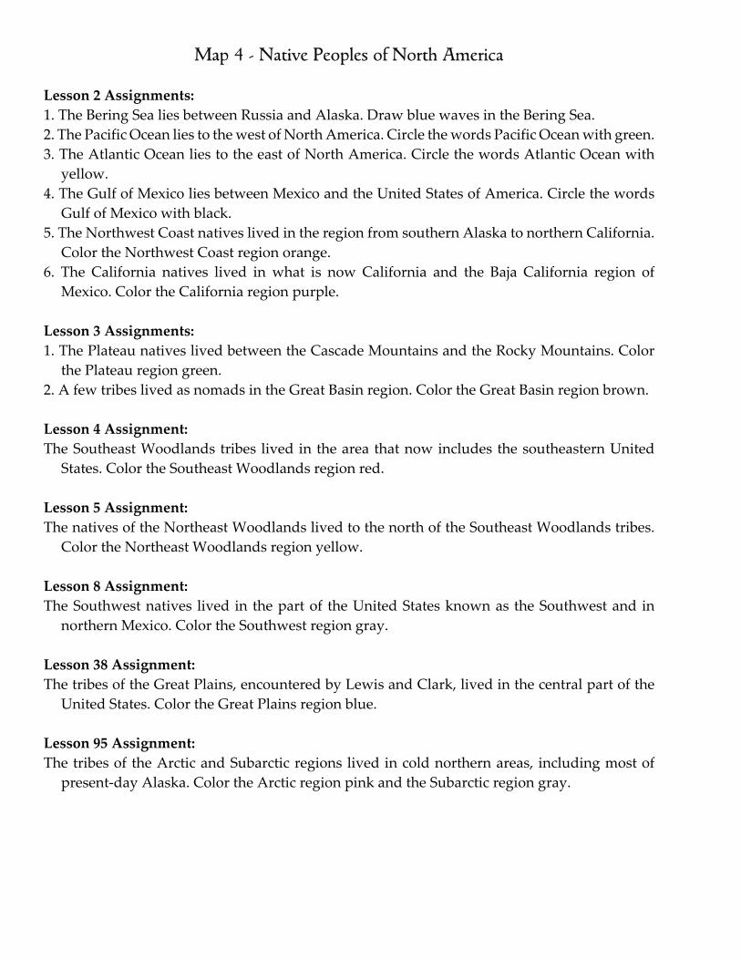
Map 4 - Native Peoples of North America
Lesson 2 Assignments:1. The Bering Sea lies between Russia and Alaska. Draw blue waves in the Bering Sea.2. The Pacific Ocean lies to the west of North America. Circle the words Pacific Ocean with green.3. The Atlantic Ocean lies to the east of North America. Circle the words Atlantic Ocean with
yellow.4. The Gulf of Mexico lies between Mexico and the United States of America. Circle the words
Gulf of Mexico with black.5. The Northwest Coast natives lived in the region from southern Alaska to northern California.
Color the Northwest Coast region orange.6. The California natives lived in what is now California and the Baja California region of
Mexico. Color the California region purple.
Lesson 3 Assignments:1. The Plateau natives lived between the Cascade Mountains and the Rocky Mountains. Color
the Plateau region green.2. A few tribes lived as nomads in the Great Basin region. Color the Great Basin region brown.
Lesson 4 Assignment:The Southeast Woodlands tribes lived in the area that now includes the southeastern United
States. Color the Southeast Woodlands region red.
Lesson 5 Assignment:The natives of the Northeast Woodlands lived to the north of the Southeast Woodlands tribes.
Color the Northeast Woodlands region yellow.
Lesson 8 Assignment:The Southwest natives lived in the part of the United States known as the Southwest and in
northern Mexico. Color the Southwest region gray.
Lesson 38 Assignment:The tribes of the Great Plains, encountered by Lewis and Clark, lived in the central part of the
United States. Color the Great Plains region blue.
Lesson 95 Assignment:The tribes of the Arctic and Subarctic regions lived in cold northern areas, including most of
present‐day Alaska. Color the Arctic region pink and the Subarctic region gray.

Bering Sea
Arctic Ocean
Pacific Ocean
Atlantic Ocean
Gulf of Mexico
Arctic
Subarctic
Great PlainsGreat Basin
Southwest
Plateau
Maps of America the Beautiful © 2011 Notgrass Company
Map 4 - Native Peoples of North America
Northwest C
oast

Map 5 - Europe and the Western Hemisphere
Lesson 6 Assignments:1. Scandinavia was the home of the Vikings. Circle the word Scandinavia in blue.2. The Vikings had discovered Iceland by the mid‐800s. Color Iceland green.3. Erik the Red and his family sailed to Greenland in 985. Color Greenland yellow.4. Leif Eriksson traveled from Greenland to Norway, where he became a Christian. Color
Norway gray.5. Viking artifacts have been found in Newfoundland. Color Newfoundland brown.6. Italy is the birthplace of Christopher Columbus. Color Italy red. 7. Columbus moved to Portugal after he grew up. Color Portugal orange.8. Ferdinand and Isabella of Spain sponsored the voyage of Columbus. Color Spain purple.9. Columbus and his crew stopped in the Canary Islands. Circle the Canary Islands with yellow.10. Columbus sailed through the Atlantic Ocean. Draw a box around the words Atlantic Ocean
in pink.11. Columbus first sighted land in the Bahamas, north of Cuba. Draw a circle around the
Bahamas in blue. Color Cuba green.
Lesson 7 Assignments:1. Balboa led an expedition across the Isthmus of Panama. Circle the words Isthmus of Panama
in green.2. After crossing Panama, Balboa viewed the Pacific Ocean. Circle with words Pacific Ocean in
red.3. Ponce de León was governor of the Island of Borinquen, now called Puerto Rico. Color Puerto
Rico purple. 4. Early explorers discovered many islands in the Caribbean Sea. Circle the words Caribbean Sea
in pink. 5. Ponce de León discovered the area that is now Florida when searching for Bimini. Circle the
word Florida with orange. 6. Hernando de Soto’s army sailed down the Mississippi River into the Gulf of Mexico. Draw
blue waves in the Gulf of Mexico.7. Hernando de Soto’s army entered the area that is now Mexico. Circle the word Mexico with
black.

Iceland
Greenland
Newfoundland
Portugal Spain
Canary Islands
Atlantic Ocean
Bahamas
Cuba
Isthmus of Panama
Pacific Ocean
Puerto Rico
Caribbean Sea
Gulf of MexicoMexico
South America
North America
Africa
Europe
Maps of America the Beautiful © 2011 Notgrass Company
Map 5 - Europe and the Western Hemisphere

Map 6 - Europe
Lesson 13 Assignment:
The French were the first Europeans to explore the Great Lakes region. Color France yellow.
Lesson 14 Assignments:
1. The Puritans and Separatists were from England. Color England pink.
2. A group of Separatists left England to live for a while in the Netherlands. Color the Netherlands blue.
Lesson 98 Assignments:
1. The 1910 U.S. Census recorded 900,000 new immigrants who spoke Polish. Color Poland red.
2. Many Jews who immigrated to the United States came from Russia and Germany. Color the portion of Russia shown green. Color Germany orange.
3. The Order of the Sons of Italy was founded in 1905 to help Italian immigrants in America. Color Italy green.
(Note: This map shows the modern borders of Europe. Many countries had different borders in the past.)

Maps of America the Beautiful © 2011 Notgrass Company
Iceland
England
ScotlandNorthern Ireland
Ireland
NorwaySweden
Finland
RussiaEstonia
Latvia
Poland
Belarus
Lithuania
Ukraine
Romania
Bulgaria
Turkey
Serbia
Macedonia
Bosnia andHerzegovina
Croatia
Hungary
CzechRepublic
Austria
SwitzerlandFrance
Spain
North Sea
Bay of Biscay
Mediterranean Sea
Baltic Sea
Germany
Black Sea
Ionian Sea
NorwegianSea
Atlantic Ocean
Luxembourg
English Channel
Map 6 - Europe

Map 7 - The Thirteen Colonies
Lesson 11 Assignments:1. The lost colony of Roanoke Island is a mystery. Circle
the words Roanoke Island in green.2. Jamestown was the first permanent English settlement
in North America. Circle the word Jamestown with red.
3. Virginia became a crown colony in 1624. Color Virginia yellow.
Lesson 14 Assignments:1. The Mayflower first dropped anchor near modern‐
day Provincetown, Massachusetts. Circle the word Provincetown with brown.
2. The pilgrims of the Mayflower built a settlement and named it Plymouth. Circle the word Plymouth with orange.
Lesson 15 Assignments:1. The Massachusetts Bay Company founded a
settlement named Boston. Circle the word Boston with red.
2. The colony of Massachusetts included Maine until 1820. Color Massachusetts and Maine blue.
3. Rye and Dover, New Hampshire, were founded in 1623. Circle the words Rye and Dover with black.
4. New Hampshire became a royal province in 1679. Color New Hampshire gray.
5. The first English settlement in Maryland was St. Mary’s. Circle the words St. Mary’s with green.
6. Maryland was named for Queen Henrietta Maria of England. Color Maryland purple.
7. Both Dutch and English settlers moved into what is now Connecticut. Color Connecticut pink.
8. Hartford, Connecticut, was founded by Dutch settlers. Circle the word Hartford with red.
Lesson 16 Assignments:1. Providence, Rhode Island, was begun by Roger
Williams in 1636. Circle the word Providence with green.
2. The King of England gave Rhode Island more freedom of self‐government than any other colony. Color Rhode Island purple.
3. Charles Town (now Charleston) was established in what is now South Carolina in 1670. Circle the word Charleston with orange.
4. The territory of Carolina was officially divided into North and South Carolina in 1729. Color South Carolina green. Color North Carolina brown.
Lesson 17 Assignments:1. Albany, New York, was founded by Dutch settlers.
Circle the word Albany with black.2. New Amsterdam, founded by settlers from the
Netherlands, was renamed New York after the English took control. Circle the words New York City with green.
3. Color the colony of New York brown. 4. Jersey City began as a trading post founded by the
Dutch. Circle the words Jersey City with pink.5. New Jersey is named after an island in the English
Channel. Color New Jersey green. 6. Wilmington, Delaware, is at the site of a trading post
founded in 1638 by Peter Minuit and settlers from Sweden. Circle the word Wilmington with gray. Color Delaware orange.
Lesson 18 Assignments:1. William Penn considered the founding of
Pennsylvania a Holy Experiment. Color Pennsylvania red.
2. Philadelphia was planned by William Penn. Circle the word Philadelphia with black.
Lesson 21 Assignments:1. Georgia was founded by Englishman James
Oglethorpe. Color Georgia red. 2. Savannah was the first permanent European
settlement in Georgia. Circle the word Savannah with purple.
3. The New England colonies included Connecticut, Massachusetts, Rhode Island, and New Hampshire. Trace from to along the coastline of the New England colonies with green.
4. The mid‐Atlantic colonies included Delaware, New Jersey, New York, and Pennsylvania. Trace from to along the coastline of the mid‐Atlantic colonies with pink.
5. The southern colonies included Virginia, Maryland, North Carolina, South Carolina, and Georgia. Trace from to along the coastline of the southern colonies with blue.
Lesson 31 Assignment:Between 1787 and 1790, the first thirteen states ratified America’s new Constitution. On the map, write a number inside each state to show the order in which that state ratified the Constitution. Use a black pencil.
Delaware (1) South Carolina (8)Pennsylvania (2) New Hampshire (9)New Jersey (3) Virginia (10)Georgia (4) New York (11)Connecticut (5) North Carolina (12)Massachusetts (6) Rhode Island (13)Maryland (7)

Maps of America the Beautiful © 2011 Notgrass Company
Maine(part of Massachusetts)
New York
Massachusetts
Connecticut
Pennsylvania
Virginia
Maryland
North Carolina
South Carolina
Georgia
Savannah
Charleston
Roanoke Island
Jamestown
St. Mary’s
WilmingtonPhiladelphia
Jersey City
New York City
Hartford
AlbanyBoston
Providence
Rhode Island
Plymouth
Provincetown
DoverRye
Atlantic
Map 7 - The Thirteen Colonies
Maryland
Virginia

Map
8 -
The
Gre
at L
akes
Lesson 13 Assignments:
1. The Apo
stle Island
s in Lake Su
perior are part o
f the state of W
isconsin. C
ircle the Apo
stle Island
s with green.
2. The nam
e of Lake Su
perior com
es from th
e French fo
r Upp
er Lake. Color Lake Su
perior blue.
3. The St. Mary’s River flows betw
een La
ke Sup
erior a
nd Lake Huron
. Color th
e St. M
ary’s River p
urple.
4. Lake Huron is th
e second largest o
f the Great Lakes. C
olor Lake Huron blue.
5. Lake Michigan is nam
ed fo
r the Ojib
we (Chipp
ewa) w
ord Michi‐gum
a. Color Lake Michigan blue
.
6. The Straits of M
ackina
c divide Lakes M
ichigan an
d Huron
. Circle the words Straits of M
ackina
c with brown.
7. The St. Clair River, L
ake St. C
lair, and th
e Detroit River c
onnect Lakes Huron and Erie. Color th
e St. C
lair River, L
ake St. C
lair, and th
e Detroit River o
rang
e.
8. Lake Erie is th
e shallowest o
f the Great Lakes. C
olor Lake Erie blue.
9. Point Pelee in Lake Erie is th
e southernmost p
oint of C
anad
a’s mainlan
d. Circle Po
int P
elee w
ith green.
10. T
he N
iagara River con
nects La
kes Erie and Ontario. T
race along th
e Niagara River w
ith re
d.
11. T
he N
iagara River m
akes a sud
den drop at N
iagara Falls. C
ircle the words N
iagara Falls w
ith pink.
12. L
ake Ontario w
as exp
lored by Cha
mplain in 1615. Color Lake Ontario blue.

Lake Superior
Lake
Michigan
Lake Huron
Lake Erie
Lake Ontario
Minnesota
Wisconsin
Illinois
Indian
aOhio
Penn
sylvan
ia
New York
Michigan
Michigan
Can
ada
Can
ada
Can
ada
Apo
stle Island
s Milw
aukee
Chicago
Straits of M
ackina
c
St. Mary’s River
Detroit
Detroit River
Lake St. Clair
St. Clair River
Point
Pelee
Cleveland
Niagara River
Niagara Falls
Buffa
lo
Map
s of America the Be
autiful © 2011 Notgrass Com
pany
Map
8 -
The
Gre
at L
akes