Mapping GPS Points With Quantum
9
Mapping GPS points with Quantum and adding attribute data - FOSS... http://linuxlab.sbs.umass.edu/fossgis/index.php?title=Mapping_GP... 1 of 9 5/8/2006 9:18 AM Mapping GPS points with Quantum and adding attribute data From FOSS GIS Wiki by Charlie Schweik, Maria Teresa Fernandez and Alexander Stepanov, UMASS, 2006. Table of contents 1 Goals 2 Introduction 3 Getting Started 3.1 Obtain Orthophoto for UMASS Campus 3.2 Bring Orthophoto into QGIS 3.3 Issues with projections 4 Preparing the X/Y text file 5 Create a point layer with the "Add X/Y data" Plugin 6 Create a permanent layer: shapefile, and bring it into the project 7 Label the points 8 Add attribute data to the points Goals The goal of this module is to create a point layer with locations obtained with a GPS receiver and update the database adding attribute data to the points. Introduction Most GIS packages have utilities or plugins to facilitate the direct download of GPS points from the GPS reveiver into the GIS program, and viceversa: to upload routes or coordinate pairs from a GIS layer to the GPS receiver, so you can use the GPS in the field to navigate to particular locations. If you are interested QGIS-GPS receiver interaction, we will soon have a resource available on this topic: [new page]. Also, QGIS can import GPS files already in the computer in a number of GPS formats. To translate among formats, it uses the capabilities of the open source program GPSbabel http://www.gpsbabel.org/ that should also be installed in the computer. For the purpose of this class/lab, we are presenting a generic way of creating a GIS layer from a text file with coordinate pairs. (But for your future projects, and especially if you have many GPS locations, it is advisable to download the GPS files from the receiver directly into QGIS). Getting Started The other day in the geocatching lab, this was your cache location in UTM zone 18N coordinates (the datum is WGS 84): Cache: lat 904787.83 long 114766.849
Transcript of Mapping GPS Points With Quantum

Mapping GPS points with Quantum and adding attribute data - FOSS... http://linuxlab.sbs.umass.edu/fossgis/index.php?title=Mapping_GP...
1 of 9 5/8/2006 9:18 AM
Mapping GPS points with Quantum and adding attribute dataFrom FOSS GIS Wiki
by Charlie Schweik, Maria Teresa Fernandez and Alexander Stepanov, UMASS, 2006.
Table of contents1 Goals2 Introduction3 Getting Started
3.1 Obtain Orthophoto for UMASS Campus3.2 Bring Orthophoto into QGIS3.3 Issues with projections
4 Preparing the X/Y text file5 Create a point layer with the "Add X/Y data" Plugin6 Create a permanent layer: shapefile, and bring it into the project7 Label the points8 Add attribute data to the points
Goals
The goal of this module is to create a point layer with locations obtained with a GPS receiver and update the database adding attribute data to the points.
Introduction
Most GIS packages have utilities or plugins to facilitate the direct download of GPS points from the GPS reveiver into the GIS program, and viceversa: to upload routes or coordinate pairs from a GIS layer to the GPS receiver, so you can use the GPS in the field to navigate to particular locations. If you are interested QGIS-GPS receiver interaction, we will soon have a resource available on this topic: [new page].
Also, QGIS can import GPS files already in the computer in a number of GPS formats. To translate among formats, it uses the capabilities of the open source program GPSbabel http://www.gpsbabel.org/ that should also be installed in the computer.
For the purpose of this class/lab, we are presenting a generic way of creating a GIS layer from a text file with coordinate pairs. (But for your future projects, and especially if you have many GPS locations, it is advisable to download the GPS files from the receiver directly into QGIS).
Getting Started
The other day in the geocatching lab, this was your cache location in UTM zone 18N coordinates (the datum is WGS 84):
Cache: lat 904787.83 long 114766.849

Mapping GPS points with Quantum and adding attribute data - FOSS... http://linuxlab.sbs.umass.edu/fossgis/index.php?title=Mapping_GP...
2 of 9 5/8/2006 9:18 AM
We will map this point over an orthophoto of the UMASS campus.
Obtain Orthophoto for UMASS Campus
Go to MassGIS and download the 1:5,000 Black & White Digital Ortho Images at ftp://data.massgis.state.ma.us/pub/ortho5/ (This is good practice for the upcoming take-home exam).
The next image shows the orthophoto ids for the Amherst area: the UMASS campus is partially covered by OQs #117902. Download and unzip to your work directory. Remember you should also get the ".twf" file.
Bring Orthophoto into QGIS
Open QGIS and add the orthophoto quad. Define the projection: State Plane, NAD83, Mass Mainland.
Issues with projections
Now we need to be careful with the projections or the data won't overlay properly. QGIS can handle "on the fly projection" for VECTOR layers. But here, we are combining raster (the orthophoto) and vector (the GPS point layer) into the same project. After repeated tests, we confirmed that if we bring the GPS layer into QGIS in UTM coordinates, the "on the fly projection " will not only fail, but the program will become very unstable and eventually crash. QGIS does not provide the functionality of projecting interactively vectors or rasters. (There are open source libraries that deal with this problem (GDAL/OGR): they are tools to translate among raster and vector formats, but we won't introduce them in this course).
The easiest solution will be to convert the UTM coordinates into State Plane, so they will match with the raster. We found some applets in the web that will help you with this translation in two steps: First, you will convert the UTM coordinates to Geographical in this website:
http://jeeep.com/details/coord/
Introduce the UTM coordinates and click "submit". Cache: lat 904787.83 long 114766.849
Figure 1: OQ Ids for Amherst

Mapping GPS points with Quantum and adding attribute data - FOSS... http://linuxlab.sbs.umass.edu/fossgis/index.php?title=Mapping_GP...
3 of 9 5/8/2006 9:18 AM
Then you can go to http://www.ngs.noaa.gov/cgi-bin/spc_getpc.prl and enter the Geographical coordinates you justobtained to translate them into State Plane:
These are the GPS coordinates for the cache location in Mass State Plane system:
Figure 2: UTM to Geographical
Figure 3: Geographical to St.PL.

Mapping GPS points with Quantum and adding attribute data - FOSS... http://linuxlab.sbs.umass.edu/fossgis/index.php?title=Mapping_GP...
4 of 9 5/8/2006 9:18 AM
Preparing the X/Y text file
Now, we can prepare the delimited text file with the state plane coordinates. QGIS has a plugin (a tool that you call when you need it) that allows to turn X/Y coordinates lists into GIS layers as long as they are in a .txt (text) file. Prepare a text file with the coordinates delimited by commas "," (it could also work with other delimiters like tabs, spaces...). The first line of the file will have the names of the column headers or the field names. We've added a couple of campus locations to the cache point to provide some context.
The next image shows the x/y data organized in nice colums, the second image shows how the text file should lookfor QGIS to read it. For this lab, we will use a text composer like notepad. Name the file "Geocatching.txt" and save it in your work folder. (You could also use a spreadsheet and save the file as a csv file -comma delimited textfile-, but you will have to change the file extension to ".txt", instead of ".csv", in a file manager program).
Note that we added and "empty" column or field called "USE". In QGIS you can edit the fields in attribute tables ofshapefiles, but you cannot add or delete fields. So if you are planning to enter information about the GPS points in different fields, you should either enter all the information during the text file preparation, as we did in the column "SITE", or just enter the name of the field (as in "USE") and fill in the blanks later in QGIS.
Create a point layer with the "Add X/Y data" Plugin
In QGIS, go to the menu "Plugins" > "Plugin manager" and check "Add Delimited Text Layer":
Figure 4: State Plane Coordinates
Figure 5: Parsed text file
Figure 6: Comma delimited text file

Mapping GPS points with Quantum and adding attribute data - FOSS... http://linuxlab.sbs.umass.edu/fossgis/index.php?title=Mapping_GP...
5 of 9 5/8/2006 9:18 AM
Click in the little icon that just showed up:
Then, fill in the fields of the plugin wizard:
1. Browse to the text file with the coordinates: "Geocatching.txt"
2. Name the new layer.
3. Define the delimiter you used, in this case comma: , (dont use "")
4. Parse the file
5. Choose the field name that corresponde to latitud and longitud ("x" and "y" in this case)
Add layer! and Close.
Figure 7: Activating plugin

Mapping GPS points with Quantum and adding attribute data - FOSS... http://linuxlab.sbs.umass.edu/fossgis/index.php?title=Mapping_GP...
6 of 9 5/8/2006 9:18 AM
Create a permanent layer: shapefile, and bring it into the project
A new layer has been created. You could define the projection information for this temporary layer, but as we cannot edit it further at this stage, we will convert it first into a shapefile. Right click the layer in table of contents (TOC) and "save as shapefile". Store the shapefile in your work folder.
Delete the temporary layer from the TOC and add the shapefile you just created. Right click and define the projection in Properties (Massachusetts Mainland State Plane (Lambert Conformal Conic), NAD 83). Now your points should fall in the "right places" in the UMASS orthophoto.
Figure 8: Add XY data wizard

Mapping GPS points with Quantum and adding attribute data - FOSS... http://linuxlab.sbs.umass.edu/fossgis/index.php?title=Mapping_GP...
7 of 9 5/8/2006 9:18 AM
Label the points
Label the points using the "site" field:
This is how it should look:
Figure 9: GPS point layer over UMASS OQ
Figure 10: Labelling GPS layer

Mapping GPS points with Quantum and adding attribute data - FOSS... http://linuxlab.sbs.umass.edu/fossgis/index.php?title=Mapping_GP...
8 of 9 5/8/2006 9:18 AM
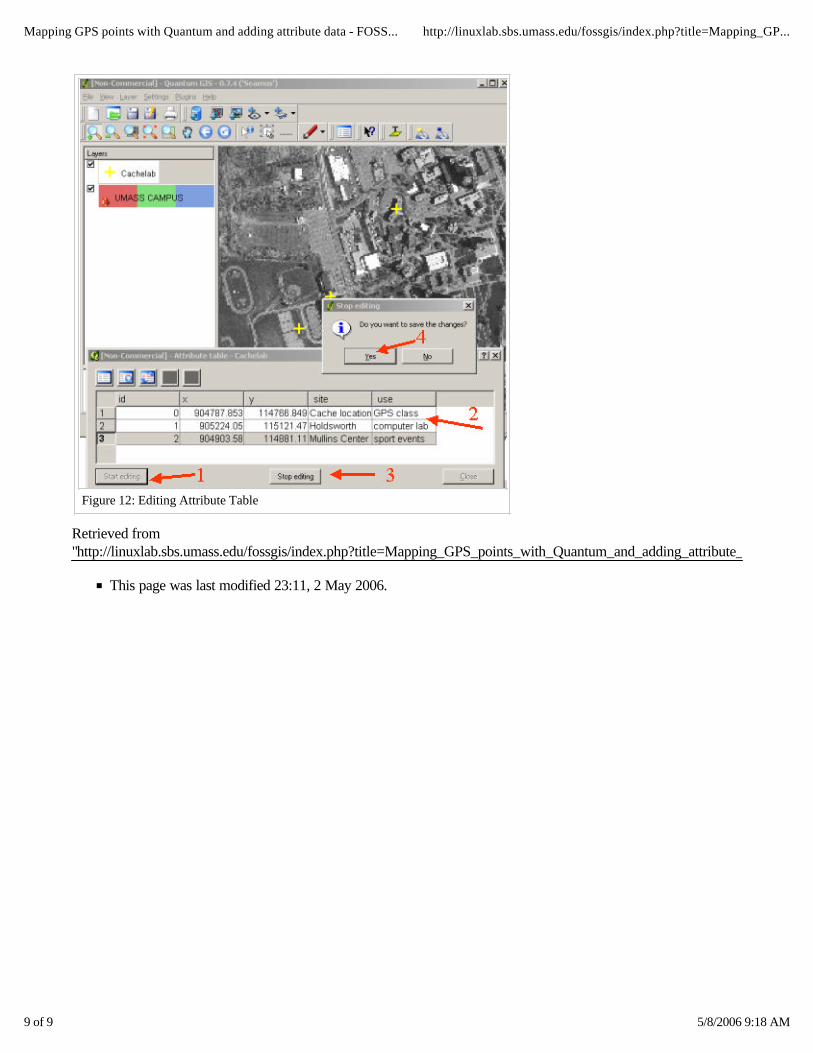
Add attribute data to the points
When you collect GPS points, you will often collect other information associated to the points. It is a common task to add that information to the database. As we mentioned before, you could add the information while you are creating the text file, or directly in the attribute table, as long as you have created the fields in the first line of the X/Y text file.
To modify the attribute table, right click the shapefile, open attribute table:
We will fill in the "USE" column. Make up your own info or copy the one provided here. Click in "start editing".Double click in the cells you want to update. After you are done with your edits, click "stop editing" and save edits.
Figure 11: Labelled layer
Figure 12: Attribute table
Mapping GPS points with Quantum and adding attribute data - FOSS... http://linuxlab.sbs.umass.edu/fossgis/index.php?title=Mapping_GP...
9 of 9 5/8/2006 9:18 AM
Retrieved from "http://linuxlab.sbs.umass.edu/fossgis/index.php?title=Mapping_GPS_points_with_Quantum_and_adding_attribute_data
This page was last modified 23:11, 2 May 2006.
Figure 12: Editing Attribute Table