MAPPING AND ANALYZING HISTORICAL SANBORN MAPS …
47
MAPPING AND ANALYZING HISTORICAL SANBORN MAPS OF SAN LUIS OBISPO FROM 1905 AND 1950 By Troy Lawson Advised by Benjamin Timms GEOG 461 & 462 Senior Project Social Sciences Department College of Liberal Arts CALIFORNIA POLYTECHNIC STATE UNIVERSITY Spring 2014
Transcript of MAPPING AND ANALYZING HISTORICAL SANBORN MAPS …

MAPPING AND ANALYZING HISTORICAL SANBORN MAPS
OF SAN LUIS OBISPO FROM 1905 AND 1950
By
Troy Lawson
Advised by
Benjamin Timms
GEOG 461 & 462
Senior Project
Social Sciences Department
College of Liberal Arts
CALIFORNIA POLYTECHNIC STATE UNIVERSITY
Spring 2014
ii
MAPPING AND ANALYZING HISTORICAL SANBORN MAPS
OF SAN LUIS OBISPO FROM 1905 AND 1950
by
Troy Lawson
ABSTRACT
This project was conducted to map, analyze, and determine historical changes in the city of San
Luis Obispo, California. Sanborn maps from 1905 and 1950 were drawn showing streets,
parcels, creeks, and buildings of the city. These publications had limited use because they were
in a physical format without any geographic reference. Here, these maps were digitized into a
GIS format to analyze building trends and identify cultural and historical buildings not on the
City’s list of Historic and Culturally Contributing Buildings, as well as published online on the
City of San Luis Obispo’s website and on ArcGIS Online. Additionally, buildings were analyzed
to find potentially historic sites over 100 years old in the city. During the past 100 years, the city
has developed and grown while maintaining its historic and cultural heritage.

iii
ACKNOWLEDGEMENTS
I would like to thank the employees of the GIS Division of the City of San Luis Obispo.
This project was made possible with the help of David Yun. I appreciate all of the time and
dedication put into helping me complete this project.
My hope with this project has been to assist the city government in their efforts to
identify, restore, and preserve the history of San Luis Obispo, and to publish this information for
the benefit of the general public.
Sincerely,
Troy Lawson
Social Science Department
California Polytechnic State University, San Luis Obispo, CA

iv
TABLE OF CONTENTS
ABSTRACT.................................................................................................................................... ii
ACKNOWLEDGEMENTS........................................................................................................... iii
TABLE OF CONTENTS............................................................................................................... iv
PROPOSAL .................................................................................................................................... v
ANNOTATED BIBLIOGRAPHY ............................................................................................... vii
OUTLINE .................................................................................................................................... xiii
INTRODUCTION .......................................................................................................................... 1
PROCEDURES .............................................................................................................................. 5
Georeferencing:........................................................................................................................... 5
Masking: ..................................................................................................................................... 8
Digitizing: ................................................................................................................................... 9
Data Driven Pages: ................................................................................................................... 11
Publishing:................................................................................................................................. 19
Online Map Applications: ......................................................................................................... 22
ANALYSIS AND RESULTS....................................................................................................... 23
Table 1....................................................................................................................................... 22
Table 2....................................................................................................................................... 22
CONCLUSION............................................................................................................................. 26
WORKS CITED ........................................................................................................................... 29

v
PROPOSAL
There is a need to disseminate historical information that is locked up or archived by
digitizing, cleaning up, analyzing, and publishing. This is important because this is data that
should be available to the public and can aid the city government for current and future historical
preservation programs. How can we get this data and show it to the public? By scanning physical
maps from 1903/1905 and 1950, georeferencing, rectifying, and digitizing all of their buildings
over current road, parcel, and creek layers. It will be accomplished using already made historical
Sanborn Maps of San Luis Obispo, and ArcGIS 10.2.
After digitizing the building footprints for 1905 and 1950, the next steps will be analysis
and publication of the results.
1st Proposal: Comparison of Buildings from 1905, 1950, 2013.
• Identify any missing buildings that could be “contributing”
• Identify trends or changes
• Update City of San Luis Obispo Contributing Properties List and Master List
2nd Proposal: Disseminate information.
• ArcGIS online: Provide online applications to visualize historic information.
o Mosaic-Three maps side-by-side using data driven pages.
o Identification-One map consisting of three layers to illustrate changes.
• Create mosaic images of 1903/1905 and 1950 Sanborn Maps
By analyzing trends and changes in building types, we can get a better understanding of the
historical setting and context of the city of San Luis Obispo during the past 100 years. The online
map applications will enable the public to access a visualized snapshot of structural changes and

vi
historical buildings. The analysis of historical and culturally contributing buildings will help the
city government by providing an updated Master List of Historic Resources and Contributing
Properties List of Historic Resources. The City Council has deemed that historical preservation is
important and worth researching and managing historic and culturally contributing sites.
According to the city’s Historic Preservation Program Guidelines, “Historic resources lend a
sense of permanence and continuity; however, in some respects they are also fragile and
vulnerable. The values and character they impart can easily be lost through neglect, demolition
and inappropriate remodeling” (Chapter 1.3, page 3).

vii
ANNOTATED BIBLIOGRAPHY
City of San Luis Obispo. (2010, November) City of San Luis Obispo Historic Preservation Program Guidelines. San Luis Obispo, CA. Historic preservation is one of many community goals in the General Plan of the City of San Luis Obispo. It is part of the community’s core values and identity. Historic preservation embodies the fundamental belief that sustainable, successful communities are those that respect, preserve and celebrate their history and unique character. The City of San Luis Obispo intends to establish and maintain incentives to support and encourage the identification, preservation, restoration, rehabilitation, reconstruction and continued use of historic and cultural resources. These guidelines were developed by the City of San Luis Obispo’s Cultural Heritage Committee (CHC), a group of seven citizens appointed by the City Council to advise and educate the public and decision makers on historic resource preservation. Historic resources include buildings and other structures, sites, landscapes, and other features that are significant in San Luis Obispo’s history. Interest in historic preservation arises out of the community’s desire to explain our past and serve as guideposts to the future. Federal, state and local governments have passed laws to protect historic properties that enjoy special merit based on age, architectural style, period, architect, owners or occupants and/or materials used. The City of San Luis Obispo is a Certified Local Government that has the responsibility of maintaining and preserving historical and cultural resources. (212 words) City of San Luis Obispo. (1983, July). Completion Report: Historical Resource Survey. San Luis Obispo, CA. Statement of purpose: The overall purpose of the Historic Resources Survey was to lay the foundation for future ongoing historic preservation projects in the City of San Luis Obispo. IN a larger and somewhat intangible context, this inventory by acting as a precedent for neighboring communities has also set a stage for expanding county-wide preservation activities… In terms of its cultural and aesthetic ramifications, the project serves to preserve a sense of past values and traditions while simultaneously helping the city adapt to future needs. It proffers a critical process for balancing the old with the new. On a more pragmatic note, the practical applications of the survey will influence zoning regulations, the alternative building code, demolition permit ordinances; and architectural review standards for design and compatibility within districts and for exterior modification to individual older properties. In March of 1981, the City of San Luis Obispo established the Cultural Heritage Committee (CHC) under Resolution Number 4660 (1981 Series). Designed as a technical, ad hoc, advisory committee, the eleven member city body was charged with primary responsibilities to establish criteria for designating historic resources; conduct a comprehensive architectural and relevant historical survey of all properties for 40 years old in the city proper; compile a master listing of meritorious properties; develop guidelines for architectural review of new structures and exterior alteration of older buildings; and disseminate findings on historic resources, rehabilitation, and pertinent preservation themes to the public.

viii
In 1904-5 a Carnegie Library designed by the California architect, William Weeks, and was built near the mission. This and the Andrews Bank Building (constructed in stages beginning a few years earlier) were Romanesque Revival in style and represented the burgeoning civic pride and grand expectations of the small city. The growth of city between 1940 and 1950 nearly doubled the population due to the opening of the Men’s Colony prison, from the returning men trained at Camp San Luis after the war, and a transition of Cal Poly to a co-ed institution. The subsequent post-Second World War housing was often constructed in large tracts around the periphery of the city where undeveloped land was most readily available for building. Proposed Districts: 3- Downtown Commercial District (central business core, commercial, religious, governmental structures. Most historic buildings date from between late 1880’s to the 1930’s. Wealthy residents build on hill to avoid flooding), Old Town District (almost fully developed by turn of century, buildings that date from 1880’s), Mill Street District (residential sector, developed later than Old Town. Large homes that date back to turn of century, also built on hill. “Due to the fear of fire after the San Francisco disaster in 1906, this neighborhood was intentionally removed from others in town and allowed more room between buildings.” Neighborhood is composed of smaller houses, some built in late 1880’s, but most added since turn of century.) Results-151 buildings in inventory. Note: Vol. 2 contains building profiles, property size in feet of frontage and depth. (483 words) Crabb, G. (2008). San Luis Obispo, 100 years of Downtown Businesses: Higuera St. San Luis Obispo, CA. Central Coast Books. The author used Polk directories to find business names in stores for every 5 years. This book follows the business history on Higuera Street in San Luis Obispo. The entries below were chosen for their identification in the Sanborn Maps circa 1905 and 1950. 674-676: 1905 Millinery (O’Leary) 1920-1980 Golden West Billiards Recreation Parlor 726: 1905 Kluver’s Cigar Store (hand rolled and sold locally) 1950-Cigar Family Restaurant Sandercock Building 856: 1905 Sandercock Transfer Co. One of the oldest family owned businesses, William Sandercock 1872. 1950 Motz Style Shop (88 words) Graves, A.R. (2004). The Portuguese Californians: Immigrants in Agriculture. San Jose, CA. Portuguese Heritage Publications of California, Inc. The San Luis Obispo IDES hall was used for many public functions, besides the Holy Ghost Festa, including the 1936 annual meeting of the Harmony Valley Creamery Association. The vast majority being Portuguese and Swiss-Italian dairymen. Selected Old World traditions were and still are fervently retained by the Portuguese community in California. One such tradition specifically helped to perpetuate the Portuguese interest in dairying. This is the annual religious-recreational celebration known commonly as the Festa do Espirito Santo, which generally includes such activities as a saying of the mass, a dance, a procession, and a banquet, typically sopas. Not all came from the Azores, but most did. Not all first worked as shepherds, but most were unskilled agricultural laborers of some sort. (122 words)

ix
Historic Resources Group (2013, September 30). City of San Luis Obispo Citywide Historic Context Statement. San Luis Obispo, CA. In order to understand the significance of the historic and architectural resources in the City of San Luis Obispo, it is necessary to examine those resources within a series of contexts. The purpose of a historic context statement is to place built resources in the appropriate historic, social, and architectural context, the relationship between an area’s physical environment and its broader history can be established. This historic context is not intended to be a comprehensive history of the City of San Luis Obispo. Rather, its purpose is to highlight trends and patterns critical to the understanding of the built environment. It identifies the various historical factors that shaped the development of the area, including historic activities or events, important people, building types, architectural styles, and materials, and patterns of physical development. The historic context provides a framework for the continuing process of identifying historic, architectural, and cultural resources in the City. It is meant to serve as a guide to enable citizens, planners, and decision-makers to evaluate the relative significance and integrity of individual properties. This Historic Context Statement is part of ongoing historic preservation efforts in the City of San Luis Obispo. The City of San Luis Obispo has an active historic preservation program, and historic preservation is included throughout City policy. Historic Preservation has been part of City policy since the 1980s, when the City established the first set of Historic Preservation Policies; the policy document was soon followed by a City historic resources survey and the formulation of the first historic districts. In 2010, the City adopted a Historic Preservation Ordinance and updated the Historic Preservation Guidelines in an effort to stimulate preservation and provide design guidance for new development. In 2012, the City of San Luis Obispo became a Certified Local Government (CLG). The CLG program is a preservation partnership between local, state, and national governments focused on promoting historic preservation at the grass roots level. The program is jointly administered by the National Park Service (NPS) and the State Historic Preservation Offices (SHPOs) in each state, with each local community working through a certification process to become recognized as a Certified CLG. CLGs then become active partners in the Federal Historic Preservation Program and the opportunities it provides. (373 words) The Monday Club. (2001, April 29). Monterey Street Secrets: Architectural Tour. San Luis Obispo, CA. Pamphlet. J.P. Andrews building- J.P. Andrews was the Great-Grandson of a Revolutionary War General, born in Tennessee and settled in San Luis Obispo County in 1859. He tore down The Eagle hotel in 1885 and built the J.P. Andrews Hotel, 3 stories high, 16 bathrooms, 112 rooms (26 suites). On April 18, 1886 the hotel burned down. The courthouse across street also caught fire but was saved; wooden buildings on Monterey Street “were but beds of ashes”. In 1893, he built a new 2-story brick building, and on the first floor was Andrews Bank. Featuring a fireproof vault with iron door, the bank president’s office was one of the first to be lighted with electricity. The design is Richardson Romanesque style. It also held the city’s first public library on second floor. Andrews would build 7 more 2-story additions on Monterey and los Osos streets. L-shaped structure featured arches, typical of Richardson Romanesque. In 1940’s, first floor became a saloon (Townsend’s). (160 words)

x
The Monday Club. (2003, May 4). Secrets of Six Churches: Architectural Tour. San Luis Obispo, CA. Pamphlet. The First Presbyterian Church was dedicated in 1905, designed by architect Thornton Fitzhugh of Los Angeles, built by John Darling with a bid of $6,783.57 for construction. This included $60 to provide a tower room over the narthex (covered entry on Marsh St) for a pastor’s study. The room is now closed off, and the stairs have been removed. Traces of original steps can be seen on wall in narthex. The pipe organ was house in front arch and organist entered from Morro St. side door. The church was divided in half, with a Sunday School located in back. The First Presbyterian Church was planned so the building can be expanded. The building stones were quarried from Bishop Peak. The church grew, and in 1929 the Hart Building was dedicated, a multifunctional building. (133 words) The Monday Club. (2004, April 25). Secrets Along the Creeks: Architectural Tour. San Luis Obispo, CA. Pamphlet. The Dallidet Adobe was originally a 3-room home with adobe brick, pine beams from Cambria, and a milled lumber finish. It was acquired by Pierre Hypolite Dallidet from the Marques heirs around 1853. As Dallidet’s family grew, additional rooms were added using milled lumber, not adobe brick. He added 2 wooden bedrooms and a dining room for 9 children. His youngest son Paul lived in house until he died in 1958, and bequeathed the property to the County Historical Society. The adobe home was restored in 1959. The original property extended from Santa Rosa Street to Buchon Street. There was a planted a vineyard and a large orchard, and established the first commercial winery on central coast. When the Historical Society acquired the property, the winery building (which was in disrepair) was dismantled and salvaged in order to use the lumber to build the present carriage barn. (147 words) The Monday Club. (2006, April 23). Secrets of Mill Street Historic District: San Luis Obispo Architectural Tour. San Luis Obispo, CA. Pamphlet. 1314 Palm Street, Michael Righetti House- Queen Anne home. Michael Righetti, local diary farmer, constructed house in 1877. 6,000 sq foot, 2 story Victorian. Carved into upstairs pediment facing Johnson Ave is “AD 1877”. One of the oldest surviving wood framed houses in San Luis Obispo. Court School, 864 Santa Rosa, current site of Ludwick Center-Deed dated July 29, 1876 JP Andrews conveyed lot No. 1 of Block 32 to the Mission School District (Renamed San Luis Obispo Coastal School District). Andrews specified that he was making a gift of the property on the condition that the trustees of the school district will build a public school building within a year. Court school built in late 1876. Simple wooden structure resembled 2-story square box. Named because it was across the street from county courthouse. Stood for 65 years, vacant and decaying when US government took property for a USO building. After War, City of San Luis Obispo leased property from government and acquired title in 1957. (166 words) The Monday Club. (2007, April 29). Secrets of 6 Vintage Homes: San Luis Obispo Architectural Tour. San Luis Obispo, CA. Pamphlet.

xi
The Biddle House at 559 Pismo street: Built and originally owned by Elizabeth and John Biddle, plans were drawn in 1893. Featuring a Victorian Carpenter Gothic Revival, it was built late for its style compared to building trends in area. Carpenter-bulls eyes adornments and embellishments added to exterior to showcase carpenter’s skills. Finally built in 1897, John never lived in home due to his death from gangrene prior to completion. The 5-bedroom structure was built for $4,950. A variety of architectural styles are incorporated into the design, notably a Queen Anne spindled porch. The Biddle family lived in home until George C. Biddle passed away Nov 1985. The house fell into disrepair until 1996, where it was purchased by current owners and restored. Secrets of Sites: “Tracks from the Past” San Luis Obispo Architectural Tour. May 1, 2011. The Monday Club. The Jack House, 536 Marsh: Built between 1876-1880, “handsome Italianate” style. Owned by Robert Jack, accountant and a prominent developer of the Southern Pacific Railroad. Robert Jack born in Maine on Sept 14, 1841. Working as accountant in New York, learned that Colonel W.W. Hollister was looking for someone to bring sheep to California from Midwest. Jack became Colonel Hollister’s accountant and secretary in 1868. Met Nellie Hollister, Colonel’s niece. Married Nov 20, 1870. He had 5 children. The Jack House contains features found in most Victorian era (1840-1900) structures. It is symbolic of American tradition and western expansion. Donated to the city in 1974, it was owned by only one family for nearly 100 years. (257 words) The Monday Club. (2012, April 29). Secrets of Spanish Sites: San Luis Obispo Architectural Tour. San Luis Obispo, CA. Pamphlet. The Steiner House, located at 1061 Grove Street: Part of the Central Edition tract, land subdivided in 1894 by the West Coast Land Company. On August 10, 1928, Anna Steiner bought land from RC Hoyt, the brief owner of The Tribune. Steiner built a 4 room residence at the cost of $3,200. The design of the home reflects the plans and designs of small houses offered at time by the Architects’ Small House Service Bureau of the United States (ASHSB). Founded and headquartered in Minneapolis, the bureau sold plans for variety of small homes, and other services for people with limited incomes wanting to build small, attractive homes. The building has strong mission influences, typical Spanish Revival details: single story, flat to sloping roof covered with red tile, stucco sheathing, a recessed doorway, and a stoop of paver tiles and canales centered in gable point. Canales help drain water off of the roof. (153 words) McKeen, R. (1988). Parade along the creek: San Luis Obispo memories of the 1920s through ‘60s. Privately Printed. It was Mr. John Harford in Avila who insisted that the Chinese patriarch, Wong On, be called “Mr. San Luis”, shortened immediate to Ah (Mr.) Luis and later changed by his sons to Ah Louis. Madonna Demolishes the Courthouse-In the early thirties county supervisors decided to build a new court-house and announced that they would take bids for demolishing the three-story brick building. Alex Madonna, then only 19, came in with the low bid of $400; the next lowest bid, by an established contractor, was $4500. As demolition included the jail, Madonna bulldozed that building over, pushing the rubble up against the courthouse wall so that he could use it as a ramp to reach the third floor with his tractor. By that time, everybody in town was watching, including

xii
the other bidding contractors and county supervisors. Mortar, broken glass, bricks, slabs of marble and shafts of splintered timber covered the entire block. Excited officials who had given him the bid had expected the job to take a week; now there was the problem of cleaning up the mess. They insisted Madonna do something! So he offered to sell bricks and marble to the spectators and the crowd paid him $1600 more to let them haul away the debris. (209 words) Taylor, P. & Lees, S. (2010). 75 SLO City Sites: An informative self-guided architectural tour in historic San Luis Obispo. California Polytechnic State University, San Luis Obispo. Chinatown originally consisted of about three city blocks of restaurants, stores, boarding houses and even a “joss house” (Chinese temple). The Chinese residents called the area “Tong Yun Fow”, or Chinese People’s City. The community grew to more than 400 Chinese by 1890, making up 10 percent of San Luis Obispo’s total population. Today, the Ah Louis Building, the Me Heng Low Restaurant and Chong’s Candy Store, are the only structural remnants of “Tong Yun Fow”. (76 words) Title Insurance and Trust Company. (1972). San Luis Obispo de Tolosa: bicentennial, 1772-1972. San Luis Obispo, CA. First American Title Insurance Company. A Study of Hotels (which tragically have all burned) – The French Hotel, the famous early hostelry across from the Mission on Monterey Street, burned on January 9, 1908. The Andrews Hotel burned to the ground on April 18, 1886. It was located on Monterey and Osos Streets. Only one good thing came out of the terrible fire and that was the establishment of fire limits in this city, whereby wooden buildings could not be erected within the business section. The famous Ramona Hotel burned on November 10, 1905. (88 words)

xiii
OUTLINE
Introduction There is a need to disseminate historical information that is locked up, archived, or
inaccessible to the public. This data can be shared by digitizing, cleaning up, analyzing, and publishing the results. The public can benefit by learning about San Luis Obispo’s history over the past 100 years, and the city government can benefit from an updated list of culturally contributing buildings. For my Senior Project, I will be mapping and analyzing the historical changes in the city of San Luis Obispo, a project that has never been done before. Through digitizing buildings on the historic maps and analyzing, I will compare the city’s Contributing and Master List of Historic Resources to see if any buildings that appear in all 3 maps are not on the list. This will give potential sites for the city to review in case it is historically or culturally significant. Lastly, I will be creating mosaic images to have a composite map of San Luis Obispo in 1905 and 1950, as well as creating two online publications to create maps that the public can access in order to disseminate this information on the internet for the general public.
The City of San Luis Obispo has determined that preserving the culture and history of the area is important to its identity, and in response has dedicated time and resources towards the preservation of the city’s history. The City Council has deemed that historical preservation is important and worth researching and managing historic and culturally contributing sites. According to the city’s Historic Preservation Program Guidelines, “Historic resources lend a sense of permanence and continuity; however, in some respects they are also fragile and vulnerable. The values and character they impart can easily be lost through neglect, demolition and inappropriate remodeling” (2010, 1.3). According to the City of San Luis Obispo Citywide Historic Context Statement, “The City of San Luis Obispo has an active historic preservation program, and historic preservation is included throughout City policy. Historic Preservation has been part of City policy since the 1980s, when the City established the first set of Historic Preservation Policies; the policy document was soon followed by a City historic resources survey and the formulation of the first historic districts. In 2010, the City adopted a Historic Preservation Ordinance and updated the Historic Preservation Guidelines in an effort to stimulate preservation and provide design guidance for new development” (2013, 4). These guidelines also describe the importance of preservation in the city. The City of San Luis Obispo Historic Preservation Program Guidelines state, “Historic preservation is one of many community goals in the General Plan. It is part of the community’s core values and identity. Preservation embodies the fundamental belief that sustainable, successful communities are those that respect, preserve and celebrate their history and unique character. The City intends to establish and maintain incentives to support and encourage the identification, preservation, restoration, rehabilitation, reconstruction and continued use of historic and cultural resources” (2010, 2.2). These guidelines were adopted by the City Council as per Resolution No. 6158 in February 1987 in order to “promote preservation of historic buildings and sites and maintain our community’s heritage” (2010, 5.7). Since then, the guidelines have been revisited and were last updated in November 2010.
The City of San Luis Obispo has been interested in preserving the history of the region since the 1980s. In July of 1983, the Historical Resource Survey Completion Report was

xiv
published and began the first step towards the creation of the Historical Preservation Program. As stated by the report, “The overall purpose of the Historic Resources Survey was to lay the foundation for future ongoing historic preservation projects in the City of San Luis Obispo. In a larger and somewhat intangible context, this inventory by acting as a precedent for neighboring communities has also set a stage for expanding county-wide preservation activities… In terms of its cultural and aesthetic ramifications, the project serves to preserve a sense of past values and traditions while simultaneously helping the city adapt to future needs. It proffers a critical process for balancing the old with the new. On a more pragmatic note, the practical applications of the survey will influence zoning regulations, the alternative building code, demolition permit ordinances; and architectural review standards for design and compatibility within districts and for exterior modification to individual older properties.” This report gave the city a foundation for future programs in order to properly identify important structures, and the correct means to develop the city with cultural and historic importance in mind.
The report also gives a background on the creation of the Cultural Heritage Committee, which oversees research on sites and determines whether it has significance to the city or not. “In March of 1981, the City of San Luis Obispo established the Cultural Heritage Committee (CHC) under Resolution Number 4660 (1981 Series). Designed as a technical, ad hoc, advisory committee, the eleven member city body was charged with primary responsibilities to establish criteria for designating historic resources; conduct a comprehensive architectural and relevant historical survey of all properties for 40 years old in the city proper; compile a master listing of meritorious properties; develop guidelines for architectural review of new structures and exterior alteration of older buildings; and disseminate findings on historic resources, rehabilitation, and pertinent preservation themes to the public” (1983, p. 7).
The CHC has been key in the creation and implementation of two listings of important buildings, the Master List and the Contributing List. The Historic Guidelines state that the “Master List Resource designation may be applied to the most unique and important historic properties and resources in terms of age, architectural or historical significance, rarity, or association with important persons or events in the City’s past, meeting criteria outlined in the Historic Preservation Ordinance” (2010, p. 75) while the Contributing List Resource or Property is a “designation that may be applied to buildings or other resources at least 50 years old that maintain their original or attained historic and architectural character, and contribute either by themselves or in conjunction with other structures to the unique or historic character of a neighborhood, district, or to the City as a whole. They need not be located in a historic district. In some cases, buildings or other resources that are less than 50 years old, but are nonetheless significant based on architecture, craftsmanship or other criteria as described herein may be designated as a Contributing resource” (p. 73) The buildings on each list have been inspected and cited as conforming to their respective list requirements and will follow those characteristics in order to remain on the list.
Through my project, I will assist the city government in the analysis and identification of potentially historic sites by comparing historic maps and modern aerial photos, and by providing a geographic database of geospatially determined locations of said sites. I will also aid the public in visualizing the city layout in 1905 and 1950 through mosaic maps and web applications.

xv
History of San Luis Obispo
According to the Citywide Historic Context Statement, San Luis Obispo was first settled
by the native Chumash. In 1772, Father Junipero Serra founded Mission San Luis Obispo de Tolosa on the banks of the nearby San Luis Obispo Creek (2013, p. 13). On September 1st, 1772, the Mission San Luis Obispo de Tolosa was founded on near “Arroyo de la Huerta Viejo (later Brizzolara or Stenner Creek), which flows into San Luis Obispo Creek (near present day Dana Street), and initially consisted of a few shelters made of brush” (p. 21). However, flooding forced the Mission to relocate to its current site by 1776. The Mission “was constructed in the traditional plaza configuration, enclosed to the outside world. The church and other related buildings were originally made of adobe, tulle, and logs, making them susceptible to fires” (p. 21). After several attacks, the tiles were changed to non-flammable clay ceramics to reduce damages.
The city of San Luis Obispo was first planned on a Spanish Grid system in accordance to the Spanish “Laws of the Indies”, which were laws and regulations issued by Spain for the governance of its colonies outside Europe. The laws “were intended to guide the creation of new communities established by Spanish settlers and missionaries and contained highly detailed regulations on the location, configuration, and construction of settlements. The regulations were based on classical principles of architecture and planning and called for a plan featuring a central plaza surrounded by a rectilinear grid of streets oriented to the prevailing winds. As a result, communities constructed according to the laws are frequently situated on a diagonal orientation rather than a true north-south orientation. In San Luis Obispo, the community was first planned around the Mission San Luis Obispo de Tolosa, which served as the town's central plaza, and surrounding streets were constructed on an angle. Although the city center has expanded over time and later development conforms to a rectilinear street grid, the historic core retains its original plan and reflects the influence of these early principles” (p. 25). Later, Monterey Street would be developed as a transportation corridor and commercial thoroughfare. In 1850, William Hutton was authorized to survey and layout the town of San Luis Obispo in an American grid pattern (p. 50). South of the Spanish Grid, using High Street as the dividing line is the American grid, also called the Jeffersonian Grid. The Jeffersonian Grid runs in a perpendicular fashion, but in a North/South direction.
For much of the colonial and Mexican era, Spanish and Mexican ranchos had extended across the county. “The California Land Act of 1851 prompted a dramatic shift in the residential development of San Luis Obispo during the mid-19th century. Surrounding ranchos were subdivided into smaller parcels of land, forcing many rural landowners to migrate into the city” (p. 14). San Luis Obispo and the county also have a distinguished place in the history of California. “In 1850, the California territory became a state, with the County of San Luis Obispo as one of the original 27 counties, with a population of 300 people. In 1868, San Luis Obispo was confirmed as the County seat. 15 years later, San Luis Obispo’s population was 600 residents living within one square mile of the town center. The City of San Luis Obispo was incorporated in 1876” (p. 35). This shows the start of rapid growth and development for the city of San Luis Obispo, with nearly double the number of the county’s population living in the city 15 years later.
Because of San Luis Obispo’s remoteness, the best methods of transportation were by water (via Avila Bay) and by railroad. The railroads greatly contributed towards the development

xvi
of San Luis Obispo, and “in the late 19th century, several ethnic communities were established in San Luis Obispo, particularly as work on the railroads increased. European groups, including Italian, Swiss-Italian, Scottish, Irish, and Welsh settled in the area. The Imperial Addition tract, which was developed in 1891, and conveniently located near the Southern Pacific roundhouse, eventually became known as “Little Italy” due to the high concentration of Italian railroad workers who resided there. There was also a Portuguese community who were part of the fishing industry at Morro Bay. Chinese settlement in San Luis Obispo began during this period as well. Starting with the early years of rail transport in the region, the development of the railroad and the extension of the track to San Luis Obispo significantly influenced the growth of the city, particularly for the city’s Chinese population. Most of the construction workers who laid the extension of the track were Chinese immigrants recruited by Ah Louis, an early San Luis Obispo businessman and civic leader in the Chinese community” (p. 71).
Throughout the next century, additional tracts of land would be annexed and incorporated into the community, especially near the Southern Pacific Railroad on the east side of the city. But during the mid-20th century, San Luis Obispo grew and developed significantly, especially after World War II. “There was a great deal of residential development in San Luis Obispo from the 1940s to the 1960s. Development from this period included some infill construction in previously-established neighborhoods, along with new residential subdivisions. The presence of nearby military installations, overall post-World War II growth throughout California, and the continued influence of the California Polytechnic Institute (by this time known as the California Polytechnic State University) all played a role in the City’s post-World War II residential development” (p. 119). Camp San Luis was a major contributor towards the development of San Luis Obispo. Many soldiers that were trained or stationed at the military site during the war would return to the area to build a home and raise a family in the city. “In 1944, the Servicemen’s Readjustment Act (more commonly known as the G.I. Bill) helped military families attain the dream of home ownership. The G.I. Bill allowed veterans to purchase a home with no down payment using the FHA mortgage guarantee program. With the FHA’s low down payment requirements and attractive loan terms, for many returning G.I.s and other middle-class workers, owning a home became as affordable as renting an apartment. Constructing single-family residences in the numbers required by the population boom also necessitated developing large parcels of land, and this led to an increase in both the size and number of subdivisions and annexations recorded in San Luis Obispo in the 1950s; over half of the fifty-four subdivisions recorded between 1935 and 1965 were established between 1950 and 1959” (p. 120). With the completion of U.S. Highway 101 in 1958 and its location between San Francisco and Los Angeles, San Luis Obispo became a location for travelers and automobile tourism. The first motel was built in San Luis Obispo in 1925, but many others were constructed near the freeway in the years to come.

xvii
Methods Georeferencing:
In 1905 and 1950, the Sanborn Map Company surveyed the city of San Luis Obispo and made a book of map sheets of city parcels, streets, creeks, and buildings. My supervisor, David Yun, scanned and converted these map sheets into JPEG image files. Because these images did not have any geographic coordinates, they had to be georeferenced, or geographically and spatially placed. Using Esri’s ArcMap program, I georeferenced these sheets by identifying the streets and parcels, and then rectifying the blocks so that they were scaled and placed correctly over modern street and parcel layers. Some map sheets were disproportioned to show greater detail on the block scaled level, so I had to chop and separate several sheets into smaller pieces to maintain proper accuracy. Masking:
Because the maps had additional unnecessary information such as sheet numbers and overlapped each other, I created masking layers for each map sheet that would cover these problem areas. Polygons are drawn over these features to create a masking layer. After masking, excess information is hidden underneath. The extra data is still on the map sheet, so the mask must be manually enabled to cover the sheet and become transparent. Digitizing:
Next, I digitized every closed-walled building. An important note is that these results are not the exact numbers of buildings in the city; these results are all the buildings that were mapped by the Sanborn Map Company within the decided geographic limits. The next step was to cross-reference the list and locations of master and contributing historic buildings in the city, to identify other potential structures that are of historic age but not on the list.
After georeferencing, digitizing, and analyzing the Sanborn maps of the city of San Luis Obispo for the year 1903, I went through the same process for Sanborn maps of 1950. Like some previous map sheets, I had to divide any areas that had were not scaled correctly to each other in order to properly georeference them. Data Driven Pages:
Data Driven Pages were used to recreate the multiple map files into a single, clear image file. To create Data Driven Pages, a fish net grid was needed in order to process and combine several images into a single file. To start the grid, I created an Extent Box feature around the combined map imagery. Next, I measured the dimensions of the Extent Box to calculate how many rows and columns would be needed. Because the map size will be 40 x 40 inches, I also had to calculate the size of each pixel in respect to how many feet, resulting in a grid cell size of 1600 x 1600 feet or 8000 x 8000 pixels, with pixel equaling 0.2 feet. The 1903 grid consisted of 4 columns and 4 rows, while the 1950 grid was 5 columns and 9 rows, because the 1950s maps covered much of the north/south expansion of the city limits, and the Cal Poly campus.
After the fishnet grids were made, Data Driven Pages were created by exporting the images into a PDF folder with a highly detailed resolution of 300 DPI. Images of the map were created in each cell of the fishnet grid, dividing many overlapping map sheets

xviii
into images based on grid cells. After converting the Adobe PDF folders into individual TIF image files, the images then needed to have a geographic reference to be precisely put together. Using the fishnet grid as the reference, TFW world files were created for each TIF image. Each TFW file consisted of six lines: the x size of the pixel in inches, two lines of rotation equaling zero, the y size of the pixel in inches and negative because it moves downward, the beginning x coordinate, and the beginning y coordinate. The x and y coordinates start in the top left of the cell, and can be found in the attribute field. The TFWs must have the same name and be in the same location as the TIF images so they can properly reference their respected images. An additional step is to define the projection of the TIF images using the Define Projection Tool in ArcMap, so the images can be properly defined and not need to be georeferenced in the future.
Next, to create a single image mosaic, the program Geoexpress was used. This program creates a SID (seamless image database) file using the TIF images as tiles, and the TFW files for spatial reference. The resulting file is a single file that is a mosaic of all the incorporated TIF files. This enables large raster images to be viewed in a single image and without having to decompress the entire file individually.
This process was repeated for each map, creating two SID files of each historical map. Continued analysis was conducted by overlaying the buildings, maps, and historic properties to search for potentially culturally contributing buildings within the city.

1
INTRODUCTION
There is a need to disseminate historical information that is protected, archived, and
inaccessible to the public. This data can be shared by digitizing, analyzing, and publishing the
results. The public can benefit by learning about San Luis Obispo’s history over the past 100
years, and the city government can benefit from an updated list of culturally contributing
buildings. This Senior Project mapped and analyzed the historical changes in the city of San Luis
Obispo, a project that has never been done before. Through digitizing buildings on the historic
maps and analysis, it compared the city’s Contributing and Master List of Historic Resources to
see if any buildings that appear in all 3 maps are not on the list. This gave potential sites for the
city to review in case it is historically or culturally significant. Lastly, this project creates mosaic
images to form a composite map of San Luis Obispo in 1905 and 1950, as well as creating two
online publications to create maps that the public can access in order to disseminate this
information on the internet for the general public.
The City of San Luis Obispo has determined that preserving the culture and history of the
area is important to its identity, and in response has dedicated time and resources towards the
preservation of the city’s history. The City Council has deemed that historical preservation is
important and worth researching and managing historic and culturally contributing sites.
According to the city’s Historic Preservation Program Guidelines (2010), “Historic resources
lend a sense of permanence and continuity; however, in some respects they are also fragile and
vulnerable. The values and character they impart can easily be lost through neglect, demolition
and inappropriate remodeling” (p. 3). According to the City of San Luis Obispo Citywide
Historic Context Statement (2013):

2
The City of San Luis Obispo has an active historic preservation program, and historic preservation is included throughout City policy. Historic Preservation has been part of City policy since the 1980s, when the City established the first set of Historic Preservation Policies; the policy document was soon followed by a City historic resources survey and the formulation of the first historic districts. In 2010, the City adopted a Historic Preservation Ordinance and updated the Historic Preservation Guidelines in an effort to stimulate preservation and provide design guidance for new development (p. 4).
These guidelines also describe the importance of preservation in the city. The City of San
Luis Obispo Historic Preservation Program Guidelines state, “Historic preservation is one of
many community goals in the General Plan. It is part of the community’s core values and
identity. Preservation embodies the fundamental belief that sustainable, successful communities
are those that respect, preserve and celebrate their history and unique character. The City intends
to establish and maintain incentives to support and encourage the identification, preservation,
restoration, rehabilitation, reconstruction and continued use of historic and cultural resources”
(2010, p. 4 and p. 16). These guidelines were adopted by the City Council as per Resolution No.
6158 in February 1987 in order to “promote preservation of historic buildings and sites and
maintain our community’s heritage” (p. 82). Since then, the guidelines have been revisited and
were last updated in November 2010.
The City of San Luis Obispo has been interested in preserving the history of the region
since the 1980s. In July of 1983, the Historical Resource Survey Completion Report was
published and began the first step towards the creation of the Historical Preservation Program.
As stated by the report:
The overall purpose of the Historic Resources Survey was to lay the foundation for future ongoing historic preservation projects in the City of San Luis Obispo. In a larger and somewhat intangible context, this inventory by acting as a precedent for neighboring communities has also set a stage for expanding county-wide preservation activities… In terms of its cultural and aesthetic ramifications, the project serves to preserve a sense of past values and traditions while simultaneously helping the city adapt to future needs. It

3
proffers a critical process for balancing the old with the new. On a more pragmatic note, the practical applications of the survey will influence zoning regulations, the alternative building code, demolition permit ordinances; and architectural review standards for design and compatibility within districts and for exterior modification to individual older properties (p. 10).
This report gave the city a foundation for future programs in order to properly identify
important structures, and the correct means to develop the city with cultural and historic
importance in mind.
The report also gives a background on the creation of the Cultural Heritage Committee,
which oversees research on sites and determines whether it has significance to the city or not. In
March 1981, the City of San Luis Obispo established the Cultural Heritage Committee (CHC)
under Resolution Number 4660 (1981 Series). Created and designed as a technical, ad hoc, and
advisory committee, the eleven member group was made “to establish criteria for designating
historic resources; conduct a comprehensive architectural and relevant historical survey of all
properties for 40 years old in the city proper; compile a master listing of meritorious properties;
develop guidelines for architectural review of new structures and exterior alteration of older
buildings; and disseminate findings on historic resources, rehabilitation, and pertinent
preservation themes to the public” (1983, p. 7).
The CHC has been key in the creation and implementation of two listings of important
buildings, the Master List and the Contributing List. The Historic Guidelines state that the
Master List Resource designation may be applied to “the most unique and important historic
properties and resources in terms of age, architectural or historical significance, rarity, or
association with important persons or events in the City’s past, meeting criteria outlined in the
Historic Preservation Ordinance” (2010, p. 75) while the Contributing List Resource or Property
is a designation that may be applied “to buildings or other resources at least 50 years old that

4
maintain their original or attained historic and architectural character, and contribute either by
themselves or in conjunction with other structures to the unique or historic character of a
neighborhood, district, or to the City as a whole.” In some cases, resources can be less than 50
years old, but must be significant based on architecture, craftsmanship or other criteria as to be
designated as a Contributing resource (p. 73). The buildings on each list have been inspected and
cited as conforming to their respective list requirements and will follow those characteristics in
order to remain on the list.
In the past, the Sanborn Map Company created hand drawn maps of the city of San Luis
Obispo’s core on paper featuring parcels, streets and street measurements, creeks, water lines,
and building types and footprints. Founded in 1866 by D. A. Sanborn in New York, the Sanborn
Map Company created maps primarily used for fire and insurance reasons. Although these maps
include important details and information, in today’s digital world these physical map documents
have limited practical uses. This project will scan in historic maps and assign geographic
references, as well as recreating them in a Geographic Information System (GIS) format and
published online to be available to everyone.
This project assists the city government in the analysis and identification of potentially
historic sites by comparing historic maps and modern aerial photos, and by providing a
geographic database of geospatially determined locations of said sites. Buildings that are
considered historic or culturally significant can receive benefits and add towards a sense of
community. Sites that are not listed but potentially contributing need to be identified in order to
research their history and It also aids the public in visualizing the city layout in 1905 and 1950
through mosaic maps and web applications.

5
PROCEDURES
This type of project has never been undertaken before at the City of San Luis Obispo or
at California Polytechnic State University San Luis Obispo. The procedures were conducted in
order to digitize and georeference historical paper maps, and to analyze their contents and data.
Processing the first set of map sheets took the most time because the procedures were new and
this project became a testing ground for these methods. Georeferencing and digitizing
geographic information is not a new concept, but with an interest in the past these methods are
likely to be used for future use in the study of historical documents from a geographic and spatial
perspective.
Georeferencing:
In 1905 and 1950, the Sanborn Map Company surveyed the city of San Luis Obispo and
made a book of map sheets of city parcels, streets, creeks, and buildings. The City of San Luis
Obispo had scanned and converted these map sheets into Adobe PDF files. Because these files
did not have any geographic coordinates, they had to be georeferenced, or geographically and
spatially placed.

6
Figure 1. Example of a Sanborn Map
Sheet

7
Using Esri’s ArcMap program, these sheets were georeferenced by identifying the
identical streets and parcels, and then rectifying the blocks so that they were scaled and placed
correctly over modern street and parcel layers. Some map sheets were disproportioned to show
greater detail on the block scaled level, so chopping and separating several sheets into smaller
pieces was necessary to maintain proper accuracy. This process also converted the Adobe PDF
map sheet files into JPEG image files.
Figure 2. Map Sheet georeferenced to Streets layer.

8
Masking:
Because the maps had additional unnecessary information such as sheet numbers and
overlapped each other, masking layers were created for each map sheet that would cover these
problem areas. Polygons are drawn over these features to create a masking layer. After masking,
excess information is hidden underneath. The extra data is still on the map sheet, so the mask
must be manually enabled to cover the sheet and become transparent.
Figure 3. Creating the masking layer.

9
Figure 4. Hiding the masking layer.
Digitizing:
Next, every closed-walled building was digitized. An important note is that these results
are not the exact numbers of buildings in the city; these results are all the buildings that were
mapped by the Sanborn Map Company within the decided geographic limits. The next step was
to cross-reference the list and locations of master and contributing historic buildings in the city,
to identify other potential structures that are of historic age but not on the list.
After georeferencing, digitizing, and analyzing the Sanborn maps of the city of San Luis
Obispo for the year 1905, the same process was repeated for Sanborn maps of 1950. Like some

10
previous map sheets, areas that were not scaled correctly to each other had to be divided in order
to properly georeference them.
Figure 5. Digitizing individual buildings by type.

11
Data Driven Pages:
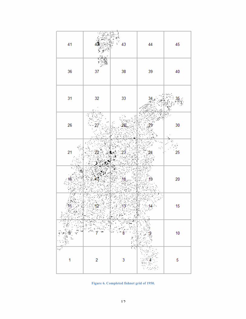
Data Driven Pages were used to recreate the multiple map files into a single, clear image
file. To create Data Driven Pages, a fish net grid was needed in order to process and combine
several images into a single file. To start the grid, an Extent Box feature was created around the
combined map imagery. Next, the dimensions of the Extent Box were measured to calculate how
many rows and columns would be needed. Because the map size will be 40 x 40 inches, it was
required to calculate the size of each pixel in respect to how many feet, resulting in a grid cell
size of 1600 x 1600 feet or 8000 x 8000 pixels, with pixel equaling 0.2 feet. The 1905 grid
consisted of 4 columns and 4 rows, while the 1950 grid was 5 columns and 9 rows, because the
1950s maps covered much of the north/south expansion of the city limits, and the Cal Poly
campus.
12
Figure 6. Completed fishnet grid of 1950.

13
After the fishnet grids were made, Data Driven Pages were created by exporting the
images into a PDF folder with a highly detailed resolution of 300 DPI. Images of the map were
created in each cell of the fishnet grid, dividing many overlapping map sheets into images based
on grid cells. After converting the Adobe PDF folders into individual TIF (Tagged Image File)
image files, the images then needed to have a geographic reference to be precisely put together.
Using the fishnet grid as the reference, TFW (TIF World File) files were created for each TIF
image. Each TFW file consisted of six lines: the x size of the pixel in inches, two lines of
rotation equaling zero, the y size of the pixel in inches and negative because it moves downward,
the beginning x coordinate, and the beginning y coordinate. The x and y coordinates start in the
top left of the cell, and can be found in the attribute field. The TFWs must have the same name
and be in the same location as the TIF images so they can properly reference their respected
images. An additional step is to define the projection of the TIF images using the Define
Projection Tool in ArcMap, so the images can be properly defined and not need to be
georeferenced in the future.

14
Figure 7. Example of a grid cell.

15
Figure 8. World File contents.

16
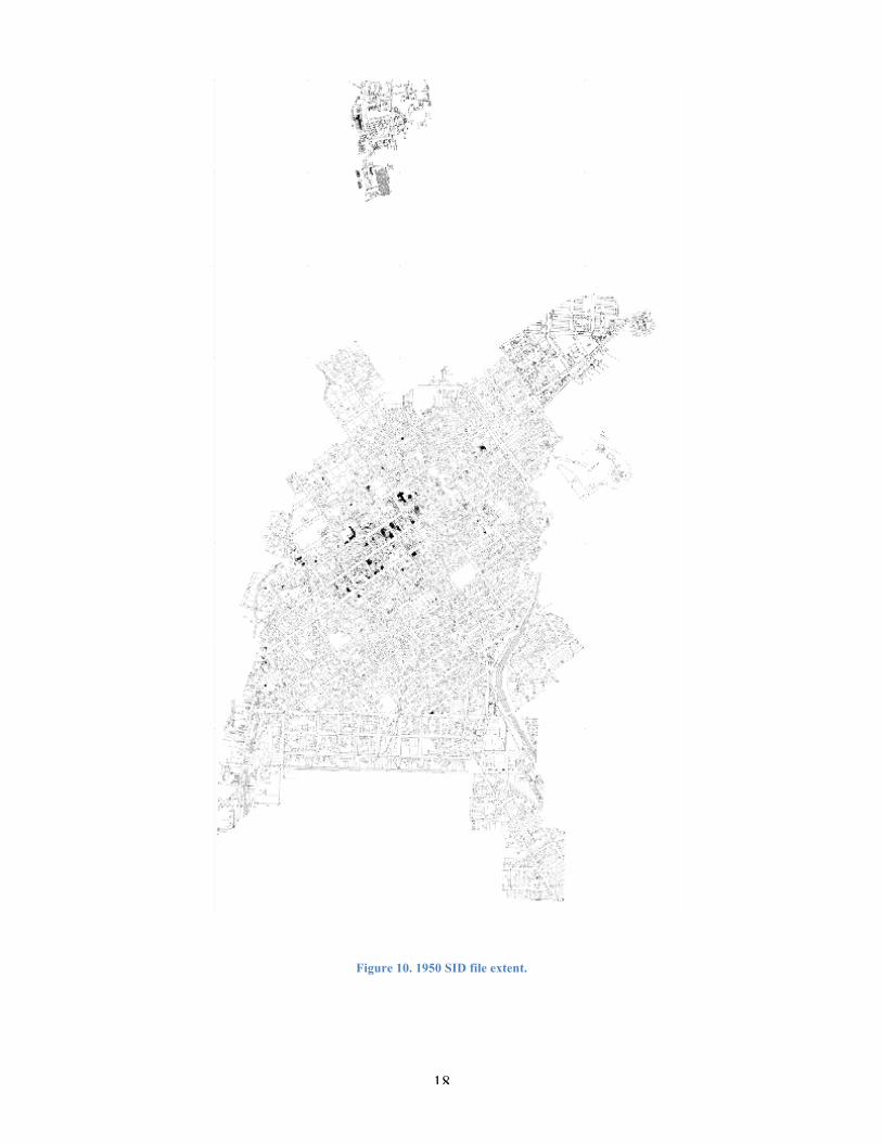
Next, to create a single image mosaic, the program GeoExpress was used. This program
creates a SID (seamless image database) file using the TIF images as tiles, and the TFW files for
spatial reference. The resulting file is a single file that is a mosaic of all the incorporated TIF
files. This enables large raster images to be viewed in a single image and without having to
decompress the entire file individually.
This process was repeated for each map, creating two SID files of each historical map.
Continued analysis was conducted by overlaying the buildings, maps, and historic properties to
search for potentially culturally contributing buildings within the city.

17
Figure 9. 1905 SID file extent.
18
Figure 10. 1950 SID file extent.

19
Publishing:
Publishing the digital maps is important in order to display the results and the findings to
the general public. Two web applications were made and published online allowing the
information to be easily distributed and understood in a digital form. The web maps, published
on the City of San Luis Obispo’s website and on ArcGIS Online, can be accessed by anyone with
an Internet connection and require no digital accounts or personal information. This allows users
to view and share the maps, which can spread awareness of city history and cultural preservation,
as well as identification of other potentially contributing sites based solely on historic footprints.
The first publication uses Esri’s premade “Storytelling Compare” application template to
display three web maps side-by-side in order to show the two historic maps and the modern
aerial photo. Because detail is significant in the analysis of the historic maps, custom scale/zoom
settings were created to clearly display the imagery, while easily bringing up and processing the
files on the fly. Seven levels were used to minimize the amount of processing while being able to
see the full extent of the aerial imagery and the details of the buildings. The selected scales range
from 1:125 ft to 1:16000 ft. This application shows the 1905, 1950, and 2011 half-foot resolution
aerial imagery side-by-side to compare development in the city over time. By checking the
“Scale” and “Location” buttons on the “Synchronize Maps” option, the three frames will match
the same scale/zoom and geographic location of the other frames in order to accurately and
identically display the same view.
The second publication is in the form of a Webmap. Although webmaps are not as
aesthetically pleasing to a general audience, they allow for some manipulation in the display of
the data, such as adjusting layer transparency, turning on/off layers, and the ability to view
attribute tables. This publication shows the 1905 Sanborn map set to an approximately 66%

20
transparency, a 2011 half-foot resolution aerial image of the city, the historically and culturally
significant properties of the city that are currently on the Master and Contributing Lists, and 85
points of possibly contributing buildings that should be reviewed. The purpose of the webmap is
to show currently listed properties and possible properties while allowing for the analysis of the
1905 map over the aerial image, and to identify any other potentially contributing properties.
Figure 11. Comparison of Sanborn Maps and Aerial Image web application.
21
Figure 12. Example of comparing details of 1950 map and 2011 imagery
Figure 13. Analysis of Historic Properties and Review Buildings web map

22
Online Map Applications:
http://slocity.maps.arcgis.com/apps/Compare/storytelling_compare/index.html?appid=e7ad9c4b5
9ac4ce5b4eb9bf0179b4411
http://www.arcgis.com/home/webmap/viewer.html?webmap=a502f65d4eec43908f374554e7446
64d
The City of San Luis Obispo’s Historic Preservation Program Guidelines (November
2010), Citywide Historic Context Statement (September 2013), and the FoxPro Application Land
Use Tool were also used to inspect historical architectural styles and parcel history to further
investigate potential contributing buildings.

23
ANALYSIS AND RESULTS
1905 Building Types Counts Churches 22 Dwellings 773 Hotels 31 Offices 24 Public Buildings 11 Railroad Buildings 42 Saloons, Entertainment 20 Shops, Services 173 Stables, Animal Related 290 Unknown 775 Vacant 24 Warehouses, Storage, Sheds 143 Total 2328
1950 Building Types Counts Automobiles 1707 Churches 24 Dwellings 2723 Hotels 171 Offices 53 Public Buildings 123 Railroad Buildings 67 Saloons, Entertainment 48 Shops, Services 488 Stables, Animal Related 27 Unknown 500 Vacant 5 Warehouses, Storage, Sheds 147 Total 6083
Table 1
Table 2

24
During the various stages of this project, it was noticed that many of the city streets are
the same size today as they were in 1905, and that some streets have moved or changed names,
such as Sycamore becoming Walnut, and today’s Pepper Street was historic Johnson Street. In
1905, the city also contained different stores and services that are not seen today, such as
gunsmiths, liveries (horses and carriages for hire), millineries (hat making), and a cultural
Chinese district. A very noticeable change is the location of the former Pacific Coast Railway
station, off of Higuera and South Street. The Pacific Coast Railway Company Grain Warehouse
is the only remaining building from the station, but today it is the location of a gas station, donut
store, and other modern businesses and services. In 1905, this area was home to a sprawling
network of rails, lumber sheds, and other train and lumber industry buildings.
One interesting difference in the city between 1905 and 1950 is the change in
transportation methods. The maps of 1905 featured many horse stables, liveries, and other pre-
automobile services. However in the middle of the century (1950), American car culture was in
full effect, seen through the number of garages near homes, the wide range of automobile related
businesses, and the advent of gas stations that were situated on street corners. As seen in the
tables, the number of mapped dwellings from 1905 to 1950 more than tripled from 773 to 2,723
polygons. By 1950, the number of Animal Related structures in the maps had decreased from
290 to 27 polygons, indicating a transportation transition from horses to automobiles.
The 1950 set of map sheets also contained the California Polytechnic State University
San Luis Obispo campus separate from the other mapped parts of the city. The 1905 maps also
featured parts of the university campus (founded in 1901), but consisted of two buildings
(Recitation/Admin and one Dormitory), as well as no geographic information such as a street or
parcel to reference. While the map sheet contained a North Arrow and a Scale Bar, the only

25
description provided to identify its location said the campus was “Located 1 1/3 miles NW of
Court Ho.” The 1950 sheets showed an increased amount of development compared to 1905.
Growth of city between 1940 and 1950 nearly doubled the population, due to opening of the
Men’s Colony prison, returning soldiers trained at Camp San Luis after World War II, and the
transition of Cal Poly into a co-ed institution. “The subsequent post-Second World War housing
was often constructed in large tracts around the periphery of the city where undeveloped land
was most readily available for building” (Completion Report, 23).
85 structures were also identified as possibilities to be reviewed for the city’s
contributing list. These properties were analyzed by inspecting identical or near-identical
building footprints placed in the same location in the 1905 Sanborn map and the 2011 aerial
image. The properties were then recorded and digitized with their 1905 and 1950 contents, and
their address. The addresses were found using Address Points created by the city, and through
the use of the FoxPro Application Land Use tool.
These properties are not on the Master or Contributing Lists, but may have already been
reviewed for eligibility in the past. Factors such as context, integrity, and alterations must be
determined before the property can be considered culturally or historically significant. The 85
points provide the city with a list of possible sites that may be important strictly on their
geographic history. It is one tool or step towards the analysis of many possibly contributing
properties.

26
CONCLUSION
By understanding history using GIS and historical documents, San Luis Obispo has seen
growth and changes while maintaining some of its historical and cultural heritage. But as the city
grew, established areas were cleared and redeveloped for changing times, such as the
construction of Highway 101 and the removal of railroad industrial sectors. This project has
shown that it is possible to manage historic data, and that it is doable to digitize and publish this
information. Through researching the past of San Luis Obispo and by using the published web
maps, it is easy to understand and appreciate the history of the city, especially seen in many of
the historic or cultural buildings.
Many of the buildings and parcels have been changed, but most of the street sizes have
been the same. In an age before automobiles were commonplace, many homes had stables for
horses and an outhouse out back. The processing of the 1950 maps was faster and more efficient
because it was the second time to go through the same steps, which resulted in saving time in
order to make the project more successful. Although the digitizing work is time consuming, it
can easily be done with patience and simple training. One way to make this project stronger in
the future is by having more customizable options in the online ArcGIS publications. One issue
with the second map application is whether to use a premade template application that is more
user-friendly and simple, or an online map that is more complicated but has more options. As of
writing, there are no online map applications that use a transparency slider, which would be a
useful way to compare several overlaid maps.

27
For the first online map application, a side-by-side comparison was used of the two
historical maps, and the modern aerial image. This was achieved by using the “Storytelling
Compare” application with three web map frames. Three map documents were made and
published in the City of San Luis Obispo’s ArcGIS online group. Each document contained one
map image or the aerial photo. Next, an application was made using the three map documents to
place the frames side-by-side, and to allow synchronized scale and location, which can be seen
by panning across the frames and by zooming in and out. Each frame will adjust to match the
others, in order to position itself in the same location at the same scale, which helps viewers
compare the images, and ideally how the city has changed from 1905, 1950, and 2011.
Additional historical maps of the city of San Luis Obispo can be digitized using the same
methods. This can show more detailed development throughout time. Because this project deals
with relatively the beginning, middle, and end of the 20th century, we can see rapid and distinct
changes in the city landscape. But by mapping Sanborn Maps from 1926 for example, we may
potentially see unique sites and buildings related to automobile travel (the first motel was built in
San Luis Obispo, in 1925), Exposition Park Race Track, and to Cal Poly as well.
Through the process of analyzing trends and changes in building types, we can get a
better understanding of the historical setting and context of the city of San Luis Obispo during
the past 100 years. The online map applications will enable the public to access a visualized
snapshot of structural changes and historical buildings, while the analysis of historical and
culturally contributing buildings will help the city government by providing possible building
locations for an updated Contributing Properties List of Historic Resources.

28
This project was presented at the California Geographical Society’s 68th Annual
Conference in Los Angeles, California on May 3rd, 2014 and won the Undergraduate Student
Digital Cartography Competition.
29
WORKS CITED
City of San Luis Obispo. (2010, November) City of San Luis Obispo Historic Preservation
Program Guidelines. San Luis Obispo, CA.
City of San Luis Obispo. (1983, July). Completion Report: Historical Resource Survey. San Luis
Obispo, CA.
Historic Resources Group (2013, September 30). City of San Luis Obispo Citywide Historic
Context Statement. San Luis Obispo, CA.
Lawson, Troy (2014). Historic Sanborn Maps. Updated March, 2014. Online.
http://slocity.maps.arcgis.com/apps/Compare/storytelling_compare/index.html?appid=e7
ad9c4b59ac4ce5b4eb9bf0179b4411
Lawson, Troy (2014). ArcGIS - San Luis Obispo Sanborn Map Historic Buildings for Review.
Updated May, 2014. Online.
http://www.arcgis.com/home/webmap/viewer.html?webmap=a502f65d4eec43908f37455
4e744664d