
Map-Scale Structures and Contact...
70
Geol341-Structural Geology Map - Scale Structures and Contact Relationships
Transcript of Map-Scale Structures and Contact...
Geol341-Structural Geology
Map-Scale Structures
and Contact
Relationships

Last Lecture
• The downward pull of subducting slabs drives plate motions
• All plate motions are rotations
• 3 kinds of plate boundaries create 3 different structural environments
• Gravity causes deformation at passive margins
• Continents grow by accretion at their edges

What type of plate boundary is
there along the US East coast?

Passive Margin

Continental Growth
• Material plastered onto the continents at
convergent boundaries
• Example:
– Everything west of Nevada has been added to
North America in last 700 Ma

Continental Growth

Today’s Outline
• Stratigraphic contacts
– Unconformities
• Primary Sedimentary Structures
– Younging direction
• Intrusive contacts
– Sills and dikes
– Batholiths
• Fault Contacts
– Normal, thrust, strike-slip
• Folds
– Anticlines, synclines

1. Superposition: younger layers on top
Red layers deposited over
tan
Tan sediment deposited
over older rock
Third layer is
youngest and is
on top
Young
Old

Stratigraphic Succession
Basalt Flows- Snake River Plain

Horizontality of Sedimentary
Successions
North Slope, AK

Horizontality of Sedimentary
Successions
North Slope, AK
Without vertical exaggeration

Basic Question:
Is the section conformable?
• Is the sedimentary pile continuous?

Unconformities
Disconformity
Angular Unconformity

Angular unconformity
Death Valley

The Great Unconformity
Grand Canyon, AZ

1.1-1.2 Ga
1.7 Ga
0.5 Ga

Angular Unconformity
In seismic data

Onlap Surface
North Slope, AK

Fossils & disconformities
Correlation = determine equivalent units
I
H
G
F
E
D
C
B
A
I
H
C
B
A

Is the sedimentary succession
right-side up?
• How can
we tell?
Which is older. A or B?
AB

Is the sedimentary succession
right-side up?
• How can
we tell?

Primary Structures
Pillow Basalts Up

Sedimentary StructuresStromatolites, Belt Gp., MT
Up

Ripples

Cross bedded sandstones

Graded beds
Up

Intrusive Contacts
They cut older rocks
• Dikes
• Sills
• Stocks
• Batholiths

Coarse-Grained
Fine-Grained
Intrusive Structures
Dikes
Sills
Stock or
batholith

Shiprock, New Mexico
Stock
Dike

Sierra
Nevada
Batholith
Yosemite N.P.

Cross Cutting RelationshipsYounger intrusive cuts through older folds
Amato photo, Burro Mts, NM
1.6 Ga Amphibolite
1.4 Ga
Dikes

Geologic history of an area
based on contact relationships


Orientation of a Plane

Salisbury Crags, Edinburgh, UK,
BGS photo
Jointed gabbro sill

Strike and dip on a map
North
34
38
28
30
Blue Fm.
Grey Fm.

Angular
Unconformity
Map View
Alabama
uK1 =Upper
Cretaceous
IP1 =Permian
20
22
60

Visualizing
the 3D
Structure6
Cross Section
W E

Folds
• Syncline
– (concave up)
• Anticline
– (concave down)


Domes and Basins
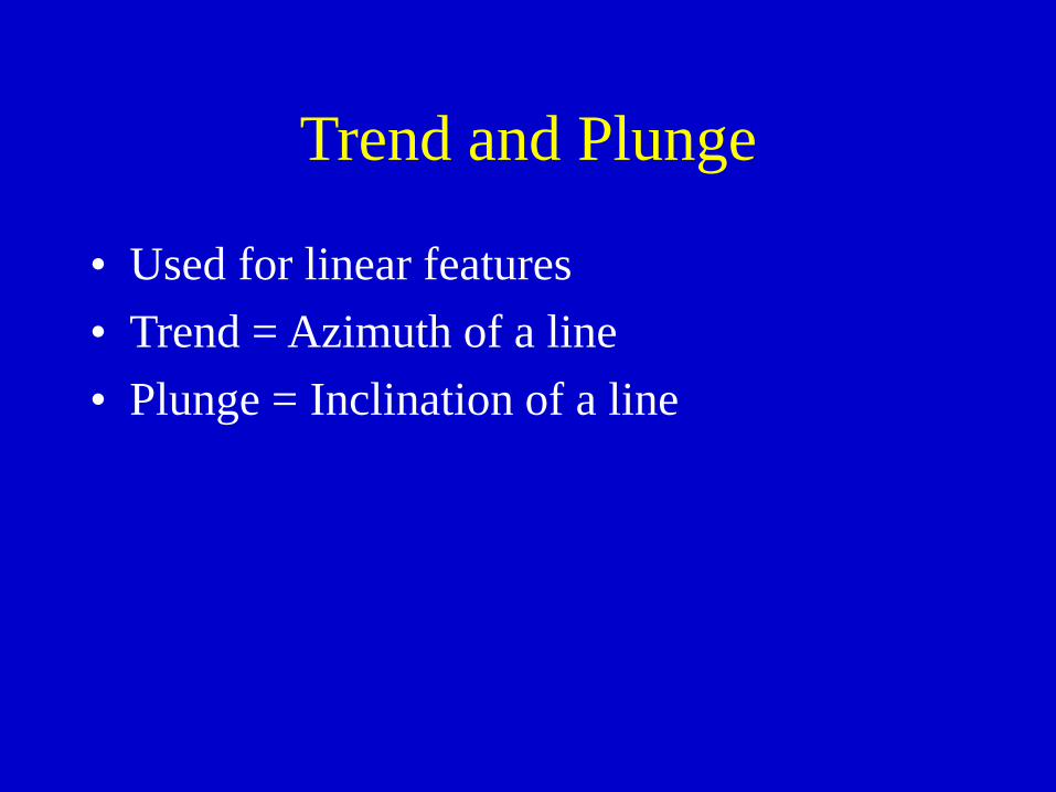
Trend and Plunge
• Used for linear features
• Trend = Azimuth of a line
• Plunge = Inclination of a line

Plunging Fold

Plunging
Folds

Does the arrow point at a syncline or anticline?
A. Syncline
B. Anticline
C. Neither


Sheep Mountain Anticline, WY

Fault Contacts
• Normal
• Thrust, reverse
• Strike-slip


Thrust Fault


Faults in Map View
Teeth Point down dip
Pen
Trias

Rose Diagram
Bins # Measurements
0-9 0
10-19 2
20-29 5
…
100-109 3

Rose Diagram Examples

Software
• Stereonet (free)
• Openstereo (free)
• StereoNet (free)
• Visible Geology (on line app- watch the
tutorial)
• Lambert (iphone app)
• Rockworks (commercial)

How the compass works

Magnetic Declination
True
North
Magnetic
North

USGS Topographic Maps
MN- Magnetic North
- True North
GN- Geomagnetic North
Morgantown Quadrangle
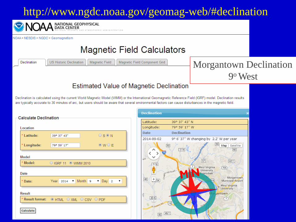
http://www.ngdc.noaa.gov/geomag-web/#declination
Morgantown Declination
9o West

Adjusting Your Compass
Front Back

Key concepts• Stratigraphic contacts
– Unconformities
• Primary Sedimentary Structures– Younging direction, right-side-up?
• Intrusive contacts– Sills and dikes
– Batholiths
– Cross cutting relationships
• Interpreting sequence of events
• Folds– Anticlines, synclines
• Fault Contacts– Normal, thrust, strike-slip


