Map Displays and Exhibits - UNLV Libraries
10
Library Faculty Publications Library Faculty/Staff Scholarship & Research 3-2012 Map Displays and Exhibits Map Displays and Exhibits Katherine Rankin University of Nevada, Las Vegas, [email protected] Follow this and additional works at: https://digitalscholarship.unlv.edu/lib_articles Part of the Archival Science Commons, Cataloging and Metadata Commons, Collection Development and Management Commons, and the Geography Commons Repository Citation Repository Citation Rankin, K. (2012). Map Displays and Exhibits. WAML Information Bulletin, 43(2), 54-62. https://digitalscholarship.unlv.edu/lib_articles/402 This Article is protected by copyright and/or related rights. It has been brought to you by Digital Scholarship@UNLV with permission from the rights-holder(s). You are free to use this Article in any way that is permitted by the copyright and related rights legislation that applies to your use. For other uses you need to obtain permission from the rights-holder(s) directly, unless additional rights are indicated by a Creative Commons license in the record and/ or on the work itself. This Article has been accepted for inclusion in Library Faculty Publications by an authorized administrator of Digital Scholarship@UNLV. For more information, please contact [email protected].
Transcript of Map Displays and Exhibits - UNLV Libraries

Library Faculty Publications Library Faculty/Staff Scholarship & Research
3-2012
Map Displays and Exhibits Map Displays and Exhibits
Katherine Rankin University of Nevada, Las Vegas, [email protected]
Follow this and additional works at: https://digitalscholarship.unlv.edu/lib_articles
Part of the Archival Science Commons, Cataloging and Metadata Commons, Collection Development
and Management Commons, and the Geography Commons
Repository Citation Repository Citation Rankin, K. (2012). Map Displays and Exhibits. WAML Information Bulletin, 43(2), 54-62. https://digitalscholarship.unlv.edu/lib_articles/402
This Article is protected by copyright and/or related rights. It has been brought to you by Digital Scholarship@UNLV with permission from the rights-holder(s). You are free to use this Article in any way that is permitted by the copyright and related rights legislation that applies to your use. For other uses you need to obtain permission from the rights-holder(s) directly, unless additional rights are indicated by a Creative Commons license in the record and/or on the work itself. This Article has been accepted for inclusion in Library Faculty Publications by an authorized administrator of Digital Scholarship@UNLV. For more information, please contact [email protected].
WAML Information Bulletin 43 (2) March 2012
54 Map Displays and Exhibits
Map Displays and Exhibitsby
Katherine L. Rankin
Special Collections [and Maps] Catalog LibrarianBibliographic & Metadata Services Dept.
University LibrariesUniversity of Nevada, Las Vegas
4505 Maryland Parkway Box 7034Las Vegas, NV 89154-7034
IntroductionMany patrons do not even know libraries have map collections, let alone what kinds of maps are in them or how they could use those maps. Map displays and exhibits can help increase interest in map collections. Muriel Strickland wrote an article on casual map displays with the title “Map Displays: a Means of Promoting Map Use” in volume 17, number 3 of the WAML IB (June 1986). One of the purposes of my writing this article is to reprise some of the valuable information in Muriel’s article; because it was published so long ago, many of the present WAML members will not have read it. The other is to add information on preservation issues involved in exhibits and information on more formal exhibits. I have also included ideas from a discussion group on map displays and exhibits held at the spring 2011 WAML meeting at the University of British Columbia. I would like to thank those who contributed ideas at that meeting. I would also like to thank Thelma B. Thompson, Gov-ernment Documents and Maps Librarian at Dimond Library at the University of New Hampshire, who sent me photos of a hybrid exhibit composed of an exhibit on historic maps created by the Osher Map Library at the University of Southern Maine, copies of some of her library’s local maps, and an exhibit of eighteenth to twentieth century surveying instruments, and photos of students from vari-ous eras using them as they did in conjunction with their civil engineering and earth sciences depart-ments. I would also like to thank Naomi Heiser at the Jerry Crail Johnson Earth Sciences & Map Library at the University of Colorado in Boulder who sent me photos of an exhibit about fairy tales that was part of a series of exhibits on geography and literature that displays maps and other items such as aerial photos along with fiction and poetry that reference places. This exhibit was done in conjunction with a lecture series on fairy tales in the humanities department of their libraries and the digitization of some fairy tales volumes in their special collections department.
DefinitionsIn Muriel Strickland’s article, she says that map exhibits are “usually presentations of a more formal nature, often in glass cases with items carefully labeled and annotated, and the whole not directly

WAML Information Bulletin 43 (2) March 2012
55Map Displays and Exhibits
related to the Map Library.” She talks in her article about more casual displays of maps, usually on the walls or the tops or sides of map cases in the map library. I am going to talk about both map displays and exhibits. Most of the map exhibits I do are in glass cases, but they are still fairly casual with a few simple captions printed out on my computer, maps simply laid in the cases or thumbtacked to the back of the case, and done with little research. Here are pictures of a formal exhibit at the Dimond Library at the University of New Hampshire (Figures 1-2) and of a casual exhibit in my library (Figure 3).
Figure 1: Formal exhibit, Dimond Library, University of New Hampshire
Figure 2: More of formal exhibit, Dimond Library
Figure 3: Casual display on Pearl Harbor

WAML Information Bulletin 43 (2) March 2012
56 Map Displays and Exhibits
Why make maps displays and exhibitsMuriel Strickland says in her article that map displays (or exhibits) are “to catch the attention; to lead people to or further into the Map Room and a realization of what a map library might be able to do for them.” I also want to tell students that they can check out the maps, so for that reason and to call attention to the exhibits I have in a small horizontal case, I have a sign on top of the case that says “Wonderful world of maps. Check them out.” (See figure 4) I also sometimes have exhibits in a vertical case on the first floor of the library (figure 5). If a person’s map collection is off the beaten path, it may be better to have exhibits in higher traffic areas.
Problems with displaying maps:
SecurityMaps on display have to be protected from theft. A person could display only maps in the open that are superseded or are duplicates or could display copies of maps. Copies of maps can be made by scanning and printing them, printing out digital maps, making copies of small maps on a color copier, or taking photos of the maps and enlarging and printing the photos. Of course, putting the maps in locking glass cases is another way to protect them. A framed map could be secured with a cable lock to keep it from being stolen.
Size issues Maps take up a lot of room, but they have to be close enough to patrons so they can read them. If they are put up high enough that patrons cannot reach them, then they are probably too high for patrons to read. Maps are also often so big it is hard to get them to stay on walls or map cases. If they are not too
Figure 4: Sign for map exhibit case Figure 5: Exhibit in vertical case: geological maps
WAML Information Bulletin 43 (2) March 2012
57Map Displays and Exhibits
big, they can be hung on metal whiteboards or map cases with magnets.
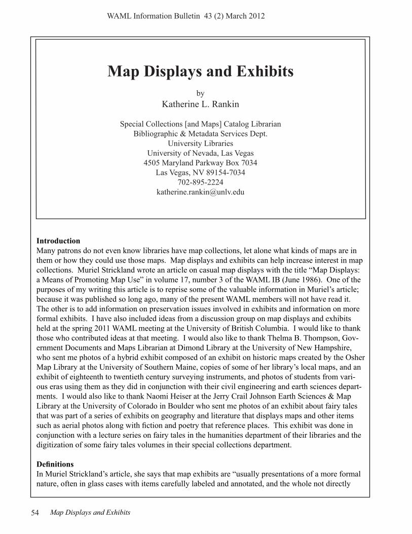
Damage from hanging maps If the maps are expendable because they are duplicates or superseded or are copies, they can be taped to map cases, which are usually smoother than walls and therefore easier to get tape to stick to, plus there is less of a chance of the tape pulling paint off a cabinet. Expendable maps or cop-ies of maps can be thumbtacked to bulletin boards. If a person does not want to make holes in the map, it is possible to hold it with a row of thumbtacks put along the edge of the map. Maps can also be hung from a picture rail with clips (see figure 6 for a map display hanging from a picture rail at Southern Missouri University in Springfield, Missouri).
Tops of horizontal maps cases are another place to display maps if the cases are not too high. A map can also be encapsulated before it is hung to keep from putting holes in the map itself and to keep it from having something spilled on it. It is better to use ultrasound or sewing instead of tape in the encapsulation process to keep maps that are hung from sliding down to the bottom of the encapsula-tion film. Other preservation considerations:
Damage from lightLight can fade maps if they are hung for a long time. Light can also weaken paper and make it more
Figure 6: Maps hanging from picture rail at Southern Missouri University

WAML Information Bulletin 43 (2) March 2012
58 Map Displays and Exhibits
brittle. Not displaying maps where sunlight will fall on them as well as limiting the time maps are hung in the light will help keep them from fading. Blinds, shades, curtains, film, or filters available as plastic sheeting or rigid panels can be put over windows. There are filters that can be put over ul-traviolet lights, and it may be possible to dim lights near maps on exhibit, although florescent lights cannot be dimmed. It is possible to buy fluorescent bulbs that put out a low amount of UV radiation. Incandescent (tungsten) light bulbs give off little or no UV radiation. Tungsten-halogen lights can be dimmed but give off lots of UV radiation, so they would need UV filters.
Dust and excess moistureHumidity can make maps curl. Cases can be sealed to keep out dust and excess moisture, and silica gel can be put in cases to absorb excess moisture in high-humidity areas. Air conditioning and de-humidification can also protect maps on display from excess moisture.
Damage from materials in cases and framesFrames and exhibit cases made out of wood and mat board not made for preservation have acid and lignins in them that can damage the maps. Plywood and other composite materials that exhibit cases are often made from can also give off harmful gases. There is acid-free and lignin-free mat board, and again maps can be encapsulated. Wood can be sealed with moisture-borne polyurethanes or two-part epoxy sealants. Wooden cases can be lined with something such as Mylar, polyethyl-ene foam sheeting, or acid-free ragboard. Fabrics such as silk are acidic, and wool gives off sulphur compounds. Better fabrics to line cases with would be undyed cotton, linen, polyester, and cotton-polyester blends. Fabric should be washed to remove sizing, and if dyed fabric is used it should be washed until no dye comes out in the water (see figure 7 for fabric being used in a case). Acid-free ragboard can be used to both protect maps from harmful materials and to support them.
Figure 7: Use of fabric to line wooden case

WAML Information Bulletin 43 (2) March 2012
59Map Displays and Exhibits
The Northeast Document Conservation Center has a website with much more information on preser-vation concerns and solutions for exhibits at: http://www.nedcc.org/resources/leaflets/2The_Environment/05ProtectingCollections.php
What to display
Kinds of maps for permanent or semi-permanent displayAs Muriel Strickland says in her article, maps on permanent or semi-permanent display should have universal appeal. If a person has room, they should include a world map, a United States map, maybe a map of Europe, a map of Canada or Mexico for states that border those countries, a map of the local state, maybe a map of the local city, and a campus map for academic libraries.
Kinds of maps for temporary displayTemporary displays can show the different kinds of maps in the map collection such as topos, cen-sus maps, Bureau of Land Management (BLM) maps, geologic maps, road maps, cadastral maps, and National Geographic Society maps. Map dealers have posters showing different types of maps. Someone suggested I make a poster about the different kinds of maps we own. I did that by having someone scan maps, and then I put the scanned images together with labels for the different kinds of maps and little blurbs about them in Microsoft Publisher (see figure 8). We have a service in the library to print posters on a large-format printer, so I had the poster printed, and I attached it to the ends of our map cabinets with heavy-duty double-sided tape as it was too heavy for magnets to hold it.
Figure 8: Map types poster

WAML Information Bulletin 43 (2) March 2012
60 Map Displays and Exhibits
A display could bring together different types of maps of one area. Some areas that Muriel Strick-land suggests that might make interesting displays are Africa, Oceania, the polar regions, Japan, Ireland, and the region around the library a person works in.
A temporary display can center on a news event. I did displays on the earthquake in Japan and on the uprising in Egypt (see figure 9). Once the news event is over, the exhibit should be taken down.
Displays can center on an environmental topic such as where hurricanes occurred in one year. A map display could center on a feature such as maps of islands. Map displays could be done for a cultural feature like national parks and monuments. Another possible theme is maps in literature (see figures 10-11 for an exhibit on maps in fairy tales)
Figure 9: News event theme for exhibit: earthquake in Japan
Figure 10: Fairy tales formal exhibit Figure 11: Fairy tales exhibit bronze pig

WAML Information Bulletin 43 (2) March 2012
61Map Displays and Exhibits
An anniversary could be the subject of a display. 2011 through 2015 is the sesquicentennial of Civil War battles, so a person could have a display with maps of battles from the Civil War year be-ing commemorated. I did a display for the seventieth anniversary of the attack on Pearl Harbor (see figure 12). A person could do an exhibit for a state, county, or city centennial or sesquicentennial by displaying maps from the history of that area.
Other special events could be the focus of a display. This year the summer Olympics will be held in London. Actually there are Olympic events all over England, and there are maps showing the different ven-ues on the web, and there are also maps of the venues in London. Muriel Strickland suggested a vacation in Europe as a dis-play subject. A person could mark the cit-ies most often visited by tourists. Exhibits can be centered on other sports events. I showed where the elite eight teams in the NCAA basketball tournament were from. For the National Finals Rodeo, which is held in Las Vegas, I labeled the towns the cowboys competing for all-around cow-boy were from (see figure 13).
Figure 12: Pearl Harbor 70th anniversary exhibit
Figure 13: Event as exhibit theme: National Finals Rodeo
WAML Information Bulletin 43 (2) March 2012
62 Map Displays and Exhibits
Another possibility is to show how symbols on maps have changed or to show how pictures on maps have changed through the years. Changes to a river channel over a period of time could be the subject of an exhibit. Maps new to the collection could be displayed as could maps requested by patrons or colorful maps.
Other hintsCaptions should not be too technical. A plastic stand that can hold a piece of paper can be used to display the title of the exhibit. A tent made with a folded piece of paper can display the captions, they can be displayed with plastic book stands, or they can be laid flat on the map.
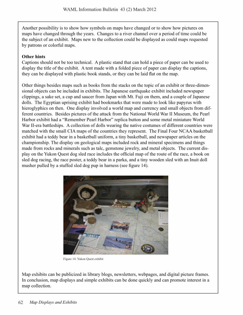
Other things besides maps such as books from the stacks on the topic of an exhibit or three-dimen-sional objects can be included in exhibits. The Japanese earthquake exhibit included newspaper clippings, a sake set, a cup and saucer from Japan with Mt. Fuji on them, and a couple of Japanese dolls. The Egyptian uprising exhibit had bookmarks that were made to look like papyrus with hieroglyphics on then. One display involved a world map and currency and small objects from dif-ferent countries. Besides pictures of the attack from the National World War II Museum, the Pearl Harbor exhibit had a “Remember Pearl Harbor” replica button and some metal miniature World War II-era battleships. A collection of dolls wearing the native costumes of different countries were matched with the small CIA maps of the countries they represent. The Final Four NCAA basketball exhibit had a teddy bear in a basketball uniform, a tiny basketball, and newspaper articles on the championship. The display on geological maps included rock and mineral specimens and things made from rocks and minerals such as talc, gemstone jewelry, and metal objects. The current dis-play on the Yukon Quest dog sled race includes the official map of the route of the race, a book on sled dog racing, the race poster, a teddy bear in a parka, and a tiny wooden sled with an Inuit doll musher pulled by a stuffed sled dog pup in harness (see figure 14).
Map exhibits can be publicized in library blogs, newsletters, webpages, and digital picture frames. In conclusion, map displays and simple exhibits can be done quickly and can promote interest in a map collection.
Figure 14: Yukon Quest exhibit


![High performance liquid crystals for vehicle displaysfor liquid-crystal-on-silicon (LCOS) reflective projection displays (e.g. HUD and wearable displays) [9], since it exhibits high](https://static.fdocuments.net/doc/165x107/6119fbf42279e26e9c7f3d70/high-performance-liquid-crystals-for-vehicle-displays-for-liquid-crystal-on-silicon.jpg)