MANUAL OF PRACTICE FOR LAND SURVEYING IN NORTH DAKOTA · 2019-02-16 · MANUAL OF PRACTICE FOR ....
187
MANUAL OF PRACTICE FOR LAND SURVEYING IN NORTH DAKOTA NORTH DAKOTA SOCIETY OF PROFESSIONAL LAND SURVEYORS Adopted May 1, 2015 Revised and Readopted February 8, 2019
Transcript of MANUAL OF PRACTICE FOR LAND SURVEYING IN NORTH DAKOTA · 2019-02-16 · MANUAL OF PRACTICE FOR ....

MANUAL OF PRACTICE FOR LAND SURVEYING IN
NORTH DAKOTA
NORTH DAKOTA SOCIETY OF PROFESSIONAL LAND SURVEYORS
Adopted May 1, 2015
Revised and Readopted February 8, 2019

MANUAL OF PRACTICE FOR LAND SURVEYING IN NORTH DAKOTA
ACKNOWLEDGEMENT SHEET FOR THIS MANUAL, ACCEPTED FEBRUARY 8, 2019
Reviewers of the Manual of Practice for Content and Accuracy Gregory Johnson (Chairman) Ken Link Aaron Hummert Matt Weeks Cleary Johs Brett Zeltinger
Contributors of Information Aaron Hummert Ken Link Matt Weeks Gregory Johnson Brett Zeltinger Tom Leshovsky Dan Fischer Cleary Johs Curtis Glasoe Brian Portwood Gregory Obrigewitsch Edward Rintamaki Gary Ness Branden Bartholomew Rick Leach Steve Langlie
We apologize to those who may have been missed, as some commenters did not leave identifiable information.
Technical writer and reviewers
Stacy Krumwiede Kylie Blanchard
Table of Contents Page 1 INTRODUCTION 1 1.1 WHY THIS MANUAL? 1 1.2 DOCUMENT HISTORY 2 1.3 RELATED HISTORICAL MATERIALS 2 1.4 LAND SURVEYOR’S RESPONSIBILITIES 3 1.5 ABOUT THE NDSPLS 3 1.5.1 Mission Statement and Objectives 4 1.5.2 Bylaws 4 1.5.3 Board of Directors 4 1.5.4 Committees 4 2 PROFESSIONAL BEHAVIOR 6 2.1 ROLE OF THE LAND SURVEYOR 6 2.2 PROFESSIONAL JUDGMENT STATEMENT 6 2.3 REGISTRATION LAWS FOR PROFESSIONAL LAND SURVEYOR 7 2.4 CODE OF ETHICS 10 2.4.1 Guidelines for Professional Conduct 11 2.4.2 Principles of Professional Conduct 11 2.4.3 Surveyor’s Creed 12 3 DEFINITIONS 13 3.1 REFERENCE MATERIALS 13 3.2 PRACTICE OF LAND SURVEYING 13 3.3 PROFESSIONAL LAND SURVEYOR 15 3.4 RETIRED REGISTRANT 15 3.4.1 Retired Surveyor (NDSPLS) 15 3.5 RESPONSIBLE CHARGE 15 3.6 DIRECT SUPERVISION 15 3.7 STREET 15 3.8 SUBDIVISION 15 3.9 OUTLOTS 16 3.10 SUBLOTS 16 3.11 AUDITOR’S LOT 17 3.12 CADASTRAL MEASUREMENTS 17 3.13 GEOGRAPHIC COORDINATE DATA BASE (GCDB) 17 3.14 GROUND DISTANCE 17 3.15 UTM ZONE 17 3.16 STATE PLANE COORDINATES 18 3.17 LOCAL COORDINATES 18 3.18 GEODETIC COORDINATES 18 3.19 GRID COORDINATES 18 3.20 EASEMENT 18 3.21 RIGHTS OF WAY 19
3.22 MAP 19 3.23 RECORD MAP 19 3.24 PLAT 20 3.24.1 Some City Plat Language Suggested and Items to Consider 20 3.25 CORNERS 21 3.25.1 Corner 21 3.25.2 Existing Corner 21 3.25.3 Obliterated Corner 21 3.25.4 Lost Corner 21 3.25.5 Accessory Corner 21 3.25.6 Control Corner 21 3.26 MONUMENT 22 3.26.1 Boundary Monument 22 3.26.2 Reference Monument 22 3.26.3 Artificial Monument 22 3.26.4 Judicial Monument 22 3.26.5 Witness Mark or Corner 22 3.27 REAL PROPERTY 22 3.28 PRESCRIPTIVE RIGHTS 23 3.29 SENIOR RIGHTS 23 3.30 WIND ENERGY EASEMENTS PROPERTY RIGHTS 23 3.31 COMMON LAW 23 3.32 ADVERSE POSSESSION 23 3.33 ACQUIESCENCE 23 3.34 PAROL EVIDENCE 24 3.35 EXHIBIT 24 4 MONUMENTS AND COORDINATE SYSTEM 25 4.1 GENERAL 25 4.1.1 Monumentation 25 4.1.2 Coordinates 27 4.2 STANDARDS 30 4.3 ORDER OF IMPORTANCE 31 4.4 PUBLIC RECORD AND AVAILABILITY LOCATIONS 31 4.5 EVIDENCE 32 5 SURVEY CORNER RECORDS 34 5.1 PUBLIC RECORDER 36 5.1.1 Acknowledgements 36 5.2 REHABILITATION 38 5.3 RESPONSIBILITY 38 6 LAND DESCRIPTIONS 39 6.1 WRITING PRINCIPLES 39 6.1.1 Writing or Reading Legal Descriptions 39 6.2 RECORD MAPS 40 6.2.1 Types 40

6.3 CERTIFICATIONS AND STATEMENTS 40 7 SUBDIVISION OF SECTIONS 42 7.1 PLATTING LAWS AND REGULATIONS 42 7.2 PROCEDURES-REFERENCES 44 8 SURVEYS 45 8.1 BOUNDARY SURVEYS 45 8.2 SURVEY STANDARD 45 8.2.1 Accuracy Standards 45 8.3 AUDITORS SURVEY 45 8.4 PROPERTY SURVEY 45 8.4.1 Classification of Property Surveys 46 8.4.1.1 City Lot Survey Recommendations 46 8.4.1.2 Possible Additional Required Permits, etc. 46 8.4.1.2a Road Approach Permit 46 8.4.1.2b Special Flood Hazard Review 47 8.4.1.2c Site Plan Review 47 8.4.1.2d Erosion and Sediment Control Permit (ESC) 47 8.5 CADASTRAL SURVEYS 47 8.6 LOCATION SURVEYS 47 8.7 IMPROVEMENT SURVEYS 48 8.8 CITY SURVEYS 48 8.9 LOT SURVEYS 48 8.9.1 Common Steps for Lot Surveys 48 8.10 ELEVATION SURVEYS 49 8.10.1 Important Guidelines for Elevation Surveys 49 8.10.2 Elevation Certificates 49 8.10.3 FEMA Elevation Certificates 50 8.11 PLOT PLANS 50 8.12 RURAL SURVEYS 50 8.13 MORTGAGE SURVEYS 50 8.13.1 Mortgage Loan Survey Requirements 51 8.14 CONDOMINIUM SURVEYS 52 8.14.1 Condominium Laws 52 8.15 WIND TOWERS 54 8.16 CELL TOWERS 54 8.17 EASEMENT SURVEYS 54 8.18 RIGHT OF WAY SURVEYS 56 8.19 PIPELINE SURVEYS 57 8.20 WATER WELL PIVOT SURVEYS 59 8.21 ROADWAYS 59 8.22 AS-BUILT OR POST CONSTRUCTION SURVEYS 59 8.23 ALTA SURVEYS 59 8.24 LAND TITLE SURVEYS 59 8.25 RECORD DRAWINGS OR AS-BUILT DRAWINGS 59

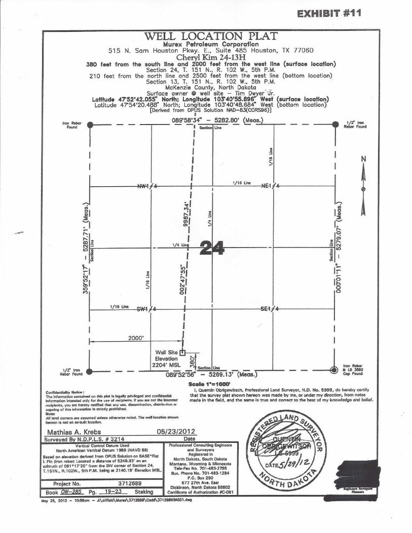
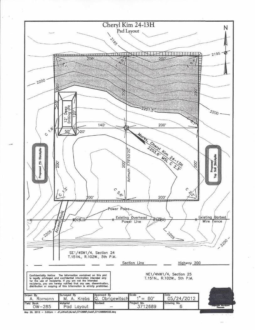
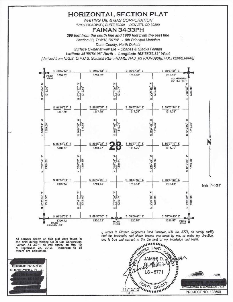
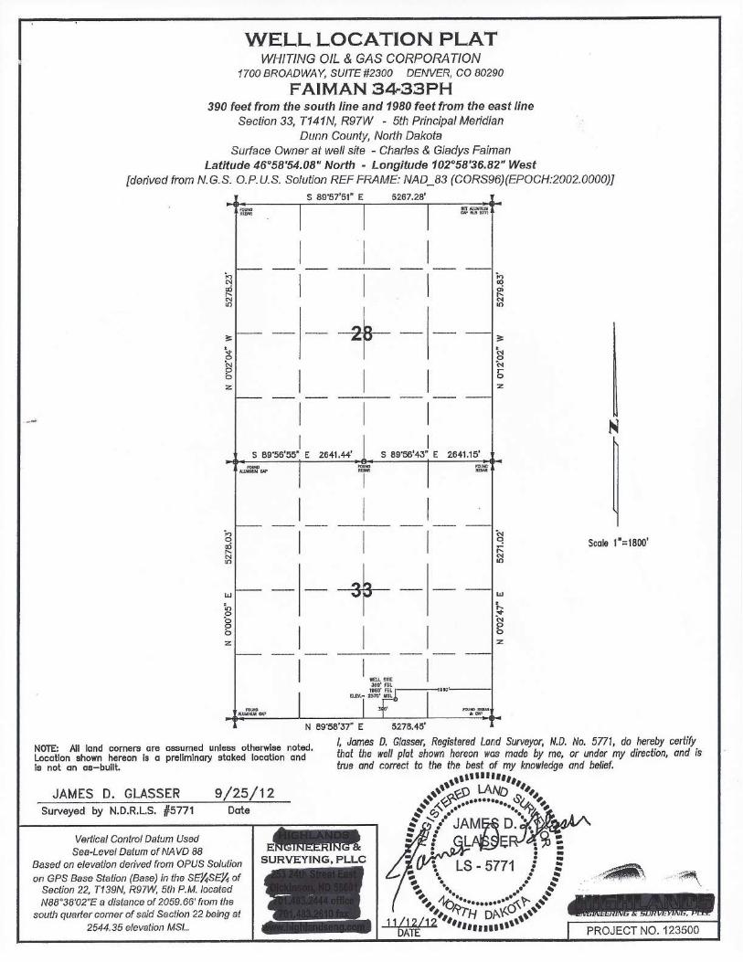
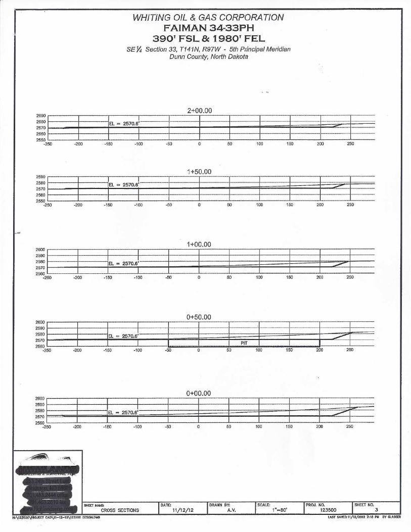
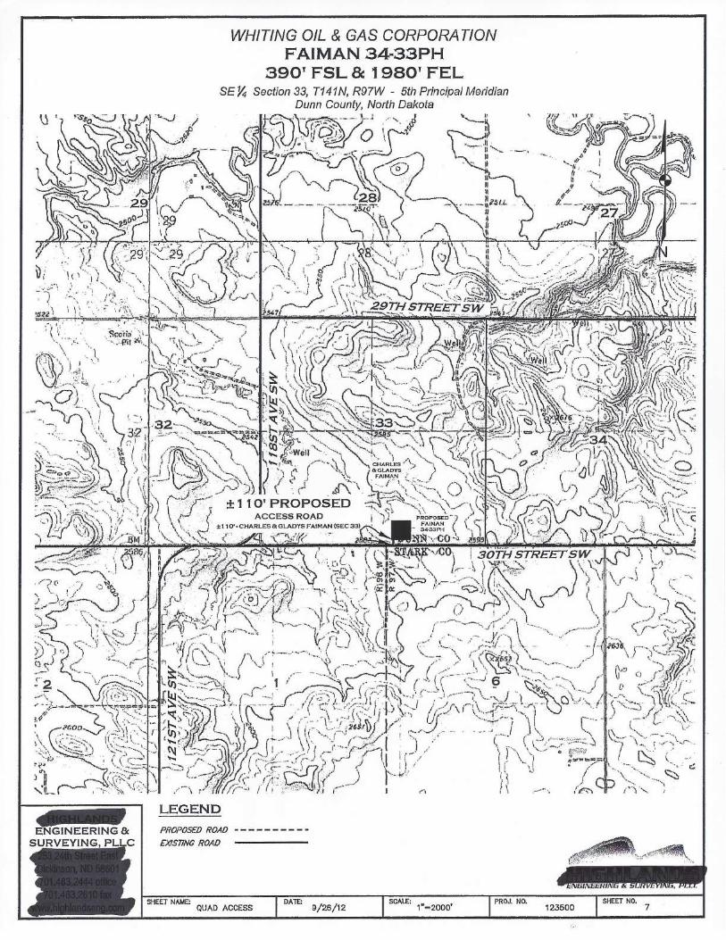
8.26 TOPOGRAPHICAL SURVEYS 60 8.27 PRELIMINARY SURVEYS 60 8.27.1 Content and Statements 61 8.28 COMPILED MAPS 61 9 GPS SURVEYS 62 9.1 GPS GUIDELINES 62 9.2 GNSS SURVEYS 63 9.3 COORDINATE SYSTEMS, DATUMS, GEOID MODELS, and UNITS OF MEASUREMENT IN ND 63 9.3.1 Local Coordinate System 63 9.3.2 Universal Transverse Mercator (UTM) 63 9.3.3 NAD 27 64 9.3.4 NAD 83 64 9.3.5 State Plane Coordinates 65 9.4 VERTICAL INFORMATION 65 9.4.1 National Geodetic Vertical Datum of 1929 (NGVD 29) 65 9.4.2 North American Vertical Datum of 1988 (NAVD 88) 65 9.4.3 Geoid Models 65 9.5 STANDARDS FOR POSITIONAL ACCURACY 66 9.5.1 About These Guidelines 66 9.6 FIELD DATA ACQUISITION METHODS 67 9.6.1 Static Positioning 68 9.6.2 Fast-Static Positioning 68 9.6.3 Post-Processed Kinematic (PPK) Survey Methods 68 9.6.4 Real Time Kinematic (RTK) Positioning 69 9.6.5 Cadastral Project Control 69 9.6.6 Cadastral Measurements 71 9.6.7 RTK Corner Measurements 72 9.6.7.1 Recommended Methods for RTK Corner Measurement 72 9.6.7.2 RTK Calibrations 73 9.6.7.3 RTK Corner Moves (stakeout) 74 9.7 REPORTING BEARINGS AND DISTANCES 75 9.8 SINGLE BASE: ONLINE POSITIONING USER SERVICE (OPUS) 75 9.9 QUALITY ASSURANCE 77 10 GIS SURVEYS 79 11 OIL AND GAS WELL SURVEYS 81 11.1 MAPS AND PLATS 81 11.2 PLAT REQUIREMENTS 81 11.3 ATTORNEY GENERAL’S OPINION 84 11.4 GENERAL PROCEDURES 85

11.5 SEE ALSO EXHIBITS 85 12 TECHNICAL SPECIFICATIONS 86 12.1 SURVEYORS REPORT 86 13 HELPFUL CASE LAW REFERENCES AND NDCC REFERENCES 87 13.1 ORDINARY HIGH WATER MARK 87 13.2 NAVIGABLE WATERS 87 13.2.1 Overview of Navigable and Non-Navigable Waters 88 13.2.2 Waters 93 13.2.3 Riparian Tract 92 13.2.4 Navigable Water Sovereign Lands 94 13.3 SECTION LINES 94 13.3.1 Section Lines are Public Roads 96 13.3.2 Public Ways Cannot Be Obstructed 97 13.3.3 Closing a Section Line 96 13.3.4 Building a Fence Within 33 Feet Or Across a Section Line 97 13.3.5 Cattle Guard Across A Section Line 98 13.3.6 Is There an Alternative to Having the Section Line Closed? 98 13.3.7 Enforcement 99 13.3.8 Notice and Removal OF Fences 99 13.3.9 Fence and Gate Cannot Be Destroyed; Gate Must Be Closed 100 13.3.10 Court Cases 101 13.3.11 Conclusion 102 14 SURVEY TYPES AND REFERENCES TO NDCC AND THE LAW DIGEST ITEMS 103 14.1 SERVICE AGREEMENTS AND PROCEDURES SERVICE AGREEMENTS MODELS/ HOLD HARMLESS INDEMNIFICATION SHEET 103 14.2 PROCEDURAL OUTLINE 103 14.2.1 Determine the Scope of a Project 103 14.2.2 Final Land Description, Records, and Research 103 14.2.3 Evaluate Capabilities to Complete Job 104 14.2.4 Estimate Cost and Acceptance of the Project 104 14.2.5 Prepare for Field Surveys 104 14.2.6 Conduct Preliminary Field Investigation 105 14.2.7 Finalize Findings 105 14.3 HISTORY OF SUBLOTS 106
14.4 PLATTING IRREGULARITIES 107 14.4.1 Auditors Plat 107

14.4.2 Auditors Lot 108 14.4.3 Platting Irregularities (Auditor’s Lots, Irregular Tracts, Outlots, Sublots, etc.) 108 14.5 CADASTRAL SURVEY STRUCTURE 111 14.6 PHOTOGRAMMETRY 113 14.7 UNMANNED AIRCRAFT SYSTEM (UAS) 113 14.7.1 FAA’s Small UAS Rule 114 14.8 EXAMPLE PRELIMINARY CITY PLAT SUBMITTAL CHECKLIST 115 14.9 COS (CERTIFICATE OF SURVEY) 118 14.9.1 Surveyor Statements 120 14.9.2 Filing and Recording Surveyor’s Certificate 120 14.9.3 Notice of Errors on Recorded Plat 120 14.9.4 Seals 121

C HA P TER 1 PA GE 1
Manual of Practice for Land Surveying in North Dakota
1 INTRODUCTION 1.1 WHY THIS MANUAL?
To help safeguard property and promote public welfare, the North Dakota Society of Professional Land Surveyors (NDSPLS) has prepared and adopted this manual for Land Surveyors and those interested in land surveys in North Dakota. We hope these guidelines will help Land Surveyors meet public needs and work to the highest standards possible. We urge you to use the contents of this document for all surveys relating to the creation, establishment or retracement of property boundaries in the state, oil and gas well surveys, wind towers, topographic surveys and all other surveys which fall under the definition of the practice of land surveying whether for public or private lands. This manual provides useful information about the usual or normal practice and procedures for land surveying in North Dakota. This manual attempts to familiarize the practicing Land Surveyor of North Dakota’s laws and rules, which are called statutes and are enacted by the State Legislature. Statutes can be broad in nature and do not always contain specific information. To help define the requirements contained in statutes, the government agencies can create administrative rules. These rules are contained in the North Dakota Administrative Code (NDAC). These administrative rules are enforceable, just like statutes, and all registrants are required to comply with NDAC. The chapter referred to as NDAC 28 is assigned to Professional Engineers and Professional Land Surveyors. This manual strives to relate to or reference the various codes in NDAC 28 where it is noted. Note, however, while this manual serves as a realistic and prudent guide for adequate surveying performance, Land Surveyors should continue to exercise individual skill, discretion, and judgment on each specific job. Careful consideration should be given to North Dakota Century Code (NDCC), all State and Federal statutes, ordinances, administrative Rules, State and Federal court ruling, policies, and accepted survey practices that are either not included or that may be in conflict with the guidelines contained within this manual.
C HA P TER 1 PA GE 2
Manual of Practice for Land Surveying in North Dakota
1.2 DOCUMENT HISTORY This document is intended to reflect the consensus of practicing Land Surveyors in the State of North Dakota. The following are key dates and changes:
May 1987. First draft of the Manual of Practice for Land Surveying in North Dakota. February 20, 1988. First edition approved and published. 2001. Document title changed to the Recommended Guidelines for the Practice of Land Surveying in North Dakota. February 2015. Current edition adopted. Title changed back to the Manual of Practice for Land Surveying in North Dakota.
The NDSPLS will continue to modify and revise this document to accommodate the advancement of survey technology and procedures as they develop, as well as to enrich the contents of this document. Changes are reviewed and revised by the Manual of Practice chairman and committee and approved by the NDSPLS board for adoption. All readers are encouraged to submit suggestions, questions, and concerns regarding the contents of this document to the Manual of Practice chairman. Each edition of this manual has been submitted to the North Dakota Board of Professional Engineers and Professional Land Surveyors for approval. The board uses this manual for the basis of testing new registrants and as benchmark for disciplinary action.
1.3 RELATED HISTORICAL MATERIALS Another source of useful information regarding North Dakota survey laws is the North Dakota Digest of Land Surveying Laws, originally compiled by the North Dakota State Board of Registration for Professional Engineers and Professional Land Surveyors in 1977 and made available to the surveying profession and the general public. It was developed to provide Surveyors with a reference to the new laws regarding land surveying, as well as to older regulations which were scattered throughout the NDCC, Administrative Code, and the Law Digest. This was done through the assistance of the University of North Dakota School of Law and the North Dakota State Board of Registration for Professional Engineers and Professional Land Surveyors. This law digest was last updated in 2015, and is used for survey law references in the NDSPLS Manual of Practice for Land Surveying in North Dakota.
Another excellent source of information is the Land Surveyor’s Guide to the Supreme Court of North Dakota 1889 – 2009 by Brian Portwood. This series

C HA P TER 1 PA GE 3
Manual of Practice for Land Surveying in North Dakota
has been published in the 49th Parallel in its entirety over the last few years, and deals with real cases involving North Dakota. A PDF file of this book can be viewed, printed, or downloaded, at no charge, from the NDSPLS website, www.ndspls.org. Click on “Publications” on the NDSPLS homepage to access the link to the book.
The Survey Corner Recordation Act NDCC 47-20.1-01 is a historical document that reflects and states the responsibility of the practicing Land Surveyor in getting survey corners filed for record now and in the future. It protects and perpetuates the public land survey corners and information concerning the location of such corners by requiring the systematic establishment of monuments and corners. (See Chapter 5 Survey Corner Records.)
1.4 LAND SURVEYOR’S RESPONSIBILITIES Land Surveyors practicing in North Dakota are expected to know and understand state laws, codes, and the acceptable standards of practice used by the Land Surveyors licensed and registered to work in the state, including those not already defined in North Dakota Century Code or Administrative Code. Professional Land Surveyor, or the designation “P.L.S.,” is the title used in North Dakota by individuals qualified to practice land surveying in the state. This designation can be legally used only by individuals who have been given a Professional Land Surveying license by the North Dakota State Board of Registration for Professional Engineers and Professional Land Surveyors. Professional Land Surveyors do different types of work as stated in NDCC Chapter 43-19.1-02 (8). The P.L.S. is bound by law to the highest standards of integrity, competency, and ethical conduct. Whether you work in public or private capacity or practice, and even if you simply offer to practice land surveying as defined in NDCC 43-19.1-02 (8) Practice of Land Surveying, you are expected to know about this document and understand its contents. Failure to comply with these standards could lead to charges of negligence or incompetence in the practice of land surveying.
1.5 ABOUT THE NDSPLS
The North Dakota Society of Professional Land Surveyors (NDSPLS) was established on February 16, 1979.
1.5.1 Mission Statement and Objectives The principle objectives of the North Dakota Society of Professional Land Surveyors are to unite all of the Professional Land Surveyors in the State of

C HA P TER 1 PA GE 4
Manual of Practice for Land Surveying in North Dakota
North Dakota; to elevate the standards of the surveying profession in the state of North Dakota; to establish basic minimum standards and requirements for surveys; to assist in promoting legislative and educational programs to improve the professional status of the Land Surveyor; to work in cooperation with local, county, state, tribal, and local governments in our field of endeavor; to uphold a rigid code of ethics; to strive to improve our relations with our clients and the public by doing our work with precision and integrity; to maintain a good relationship between Land Surveyors and Engineers.
1.5.2 Bylaws The NDSPLS publishes its constitution and bylaws in the current NDSPLS directory.
1.5.3 Board of Directors
To find the names and contact information for our board members, contact NDSPLS at PO Box 7370, Bismarck, North Dakota, 58507 or email: [email protected]. The board includes the following roles:
• President • President Elect • Vice President • Secretary • Treasurer • Past President • NSPS Governor • Chapter Presidents
1.5.4 Committees
The NDSPLS performs much of its work through the following committees and chairs:
• Administrative Secretary • Awards • Convention • Education • Education Assistance Program (EAP) • Ethics • GIS • Historical • Legislation & Bylaws • Membership • Nominations • Policy/Procedures Manual

C HA P TER 1 PA GE 5
Manual of Practice for Land Surveying in North Dakota
• Public Information • Guidelines for The Practice of Land Surveying In ND • Trigstar • Webpage • UAS • Special Committees

C HA P TER 2 PA GE 6
Manual of Practice for Land Surveying in North Dakota
2 PROFESSIONAL BEHAVIOR 2.1 ROLE OF THE LAND SURVEYOR
A professional exercises reasonable skill and care that any Land Surveyor of ordinary skill and prudence would exercise under similar circumstances. A professional’s duty is objective in nature and is to arrive at the best possible answer. The individual is held liable for failure to exercise due skill and care in making a survey. A professional must meet the obligations to perform the job and take complete responsibility for the work. Aid public understanding. A professional should promote public education and the appreciation of professional land surveying; as well as, promote the achievements and protect the profession from misrepresentation and misunderstanding. The NDSPLS encourages professionals to maintain interest in the public welfare and be ready to apply their special knowledge, skill, and training for the use and benefit of the public. Increasing land values in North Dakota have escalated the frequency of boundary surveys. There is an overabundance of GIS and GPS devices available on the market and some unethical people are using these devices to charge the public to locate property corners. Although these devices are useful for many things, they simply cannot tell where property boundaries are on the ground. By law, only a registered Professional Land Surveyor can make boundary determinations and that is frequently done by following the footsteps of the original surveyor. Land Surveying is an ancient profession with time honored procedures and respect shown to the original surveyor, even though some of those original works were done hundreds of years ago. Land Surveyors continue these values even today to protect the properties and interests of their clients.
2.2 PROFESSIONAL JUDGMENT STATEMENT A Professional Surveyor’s judgment is held to a high standard. It is important to properly carry out assigned duties to the public regarding liability for negligence or negligent misrepresentation. Professionals should exercise the reasonable skill and care a Land Surveyor of ordinary skill and prudence would exercise under similar circumstances. Statements made by the Land Surveyor should be factual and direct based on the information held and without bias to a client or to an adjoining landowner.

C HA P TER 2 PA GE 7
Manual of Practice for Land Surveying in North Dakota
2.3 REGISTRATION LAWS FOR PROFESSIONAL LAND SURVEYOR The NDSPLS has adopted the following sections as stated in NDAC Chapter 28-02.1-03 through Chapter 28-02.1-06. Types of registration. Engineers and Land Surveyors may become registered professional practitioners by examination, endorsement, or by temporary permit. 1. Registration by examination. Registration by examination is generally
a two-step process for those applicants who have met the general qualification requirements; who have met certain education requirements or who have the experience deemed to be satisfactory and acceptable to the board, or both; and who have successfully passed the examinations prescribed by the board.
a. The board has the written examination prepared by the national council of examiners for Engineers and Surveyors as its standard of examinations and qualifications.
b. The board may require one or more questions in examinations
measuring familiarity with the code of ethics. Similarly, in furtherance of the board’s determination of rehabilitation, an examination on the code of ethics may be required.
2. Registration by endorsement. Registration by endorsement is for
engineers or Land Surveyors who hold a current registration in another jurisdiction who substantially meet or have met, in the opinion of the board, the following requirements and qualifications:
Qualifications and requirements - Registered Land Surveyor (1) A graduate of a four-year or more land surveying or engineering program accredited by the accreditation board for engineering and technology must satisfy the following requirements:
(a) Pass an eight-hour examination in fundamentals of land surveying. (b) Have a minimum of four years of experience in land surveying work of a character satisfactory to the board and indicating that the applicant is competent to practice land surveying. (c) Pass an examination in the principles and practices of land surveying.

C HA P TER 2 PA GE 8
Manual of Practice for Land Surveying in North Dakota
(d) Pass an examination pertaining to land surveying laws, procedures, and practices in North Dakota.
(2) A graduate from a land surveying or engineering program not accredited by the accreditation board for engineering and technology and approved by the board must satisfy the following requirements:
(a) Pass an eight-hour examination in fundamentals of land surveying. (b) Have a minimum of six years of experience in land surveying work of a character satisfactory to the board and indicating that the applicant is competent to practice land surveying. (c) Pass an examination in the principles and practices of land surveying. (d) Pass an examination pertaining to land surveying laws, procedures, and practices in North Dakota.
(3) All other land surveying applicants not qualifying under paragraphs 1 and 2 must satisfy the following requirements:
(a) Pass an eight-hour examination in fundamentals of land surveying. (b) Have a minimum of eight years of experience in land surveying work of a character satisfactory to the board and indicating that the applicant is competent to practice land surveying. Up to two years of credit toward experience requirements may be granted upon completion of equivalent time in a board-approved land surveying or engineering curriculum. (c) Pass an examination in the principles and practices of land surveying. (d) Pass an examination pertaining to land surveying laws, procedures, and practices in North Dakota.
3. Temporary permit - Temporary registration. Educational and
experience requirements must comply with North Dakota law. A one-time temporary permit may be issued on the basis of one project and may not exceed one year. The applicant must be legally qualified to practice in the state or country of residence and must have current registration. A temporary permit must be approved prior to submission

C HA P TER 2 PA GE 9
Manual of Practice for Land Surveying in North Dakota
of plans and specifications for the execution of a project. Temporary permits for Land Surveyors are not authorized by North Dakota law.
The NDSPLS has adopted the following section as stated in NDAC 28-02.1-04-01.
General Requirements All applicants must: 1. Complete their applications on forms furnished by the board. 2. Complete the application under oath (an affidavit is required). 3. Furnish references as required but may not include board members
or relatives of the applicant as references. 4. In the case of student applicants for the fundamentals of engineering
and for the fundamentals of land surveying examinations, certification by the dean of the college or the dean’s appropriate designee agreed upon by the board may be used in lieu of references.
Qualifications and Requirements- Land Surveyor Intern 28-02.1-06-01 Land Surveyor Intern applicants must satisfy the requirements located in North Dakota Century Code section 43-19.1-16.1. An applicant for certification as a land surveyor intern who has at least four years of qualifying land surveying experience of a character satisfactory to the board, of which a formal education in an accredited engineering or land surveying curriculum may constitute a part thereof, may receive from the board, upon passing a written examination on the fundamentals of mathematics and the basic principles of land surveying, a certificate stating that the applicant has passed the examination and been recorded as a land surveyor intern.
Qualifications and Requirements-Professional Land Surveyor by Examination
28-02.1-06-02 Professional Land Surveyor by examination. A person applying for registration as a professional land surveyor by examination must have a land surveyor intern certificate and the appropriate experience as required by North Dakota Century Code section 43-19.1-16. The experience must be prior to writing the principles and practice of surveying examination. Upon successful completion of the principles and practice of surveying examination, professional land surveyor applicants must pass an examination pertaining to land procedures and practices in North Dakota.
Application for Registration

C HA P TER 2 PA GE 1 0
Manual of Practice for Land Surveying in North Dakota
Under N.D.C.C. 43-19.1-17 Application for registrations as a professional Engineer or Land Surveyor or for certification as an Engineer intern or Land Surveyor intern must be on a form prescribed and furnished by the board containing statements made under oath, showing the applicant’s education, a detailed summary of the applicant’s technical experience, and references as required by this chapter and must be accompanied by registration fees.
2.4 CODE OF ETHICS The NDSPLS has adopted the following section as stated in NDAC 28-03.1-01-01. 28-03.1-01-01.
General Statement In order to establish and maintain a high standard of integrity, skills, and practice in the profession of engineering and land surveying, the code of ethics contained in this chapter is binding upon every person holding a certificate of registration as a professional Engineer or Land Surveyor, and upon all agents, employees, officers, or partners. This chapter is specifically designed to further safeguard the life, health, property, and public welfare of the citizens of North Dakota, and must be construed to be a reasonable exercise of the police power vested in the board of registration for professional Engineers and Land Surveyors by virtue of North Dakota Century Code chapter 43-19.1, and as such the board can establish conduct, policy, and practices to be adopted. These rules are to be read and interpreted without regard to race, creed, or sex. The Engineer or Land Surveyor who holds a certificate of registration from the board is charged with having knowledge of the existence of this chapter for professional conduct as an Engineer or Land Surveyor, and also must be deemed to be familiar with the provisions and to understand them. Such knowledge shall encompass the understanding that the practice of engineering and land surveying is a privilege as opposed to a right, and the Engineer or Land Surveyor must be forthright and candid in statements or written responses to the board or its representatives on matters pertaining to professional conduct. All references in this chapter to engineers and the profession of engineering must be deemed to include Land Surveyors and the practice of land surveying. The Engineer or Land Surveyor must be guided in all professional relations by the highest standards of integrity, and shall act in professional matters for each client or employer as a faithful agent or trustee.
2.4.1 Guidelines for Professional Conduct
The NDSPLS has adopted the following section as stated in NDAC 28-03.1-01-04.

C HA P TER 2 PA GE 1 1
Manual of Practice for Land Surveying in North Dakota
Protection of Public Registrants shall be cognizant that their first and foremost responsibility is to the public welfare in the performance of services to clients and employers. The registrant:
1. Will regard one’s duty to the public welfare as paramount. 2. Is encouraged to seek opportunities to be of constructive service in
civic affairs and work for the advancement of the safety, health, and well-being of the registrant’s community.
3. Will not complete, sign, or seal plans or specifications that are not of a design safe to the public health and welfare and in conformity with accepted standards. In the course of work on a project, if a registrant becomes aware of an action taken by the client or employer against the registrant’s advice, which violates applicable state or municipal laws and regulations and which, in the registrant’s judgment, will adversely affect the public life, health, or safety, the registrant shall take the following action:
a. Advise the client or employer in writing of the registrant’s refusal to consent to the decision and give reasons for that refusal.
2.4.2 Principles of Professional Conduct
The NDSPLS has adopted the following section as stated in NDAC 28-03.1-01-17.
Professional Conduct 1. Registrants shall indicate any reservation on a reference for an
applicant if they have reason to believe the applicant is unqualified by education, training, or experience to become licensed. The registrant’s opinion shall be based on the qualifications a reasonable and prudent professional would require an applicant to possess.
2. A registrant shall not submit a materially false statement or fail to disclose a material fact requested in connection with the application for certification or licensure in this state or any other state.
3. Registrants shall comply with the licensure laws and rules governing their professional practice in any United States jurisdiction.
4. A registrant shall not further the application for certification or licensure of another person known by the registrant to be unqualified in respect to character, education, or other relevant factor.
The member will be guided in all of his/her professional relations by the highest standards of integrity, and will act in professional matters for each client or employer as a faithful agent or trustee.

C HA P TER 2 PA GE 1 2
Manual of Practice for Land Surveying in North Dakota
1. The registrant will be realistic and honest in all estimates, reports, statements, and testimony.
2. The registrant will admit and accept his/her own errors when proven obviously wrong and refrain from distorting or altering the facts in an attempt to justify his/her decision.
3. Registrant will advise his/her client or employer when he/she believes a project will not be feasible.
4. Registrant will not accept outside employment to the detriment of his/her regular work or interest without the consent of his/her employer.
2.4.3 Surveyor’s Creed
This pledge is given to all newly registered Professional Land Surveyors in attendance at the annual convention each year. This is done with all attending Registered Land Surveyors standing with hand raised in the air to show unity to the new registrants. This pledge is taken very seriously by the NDSPLS and North Dakota licensed surveyors.
As a Professional Land Surveyor, I dedicate my professional knowledge and skills to the advancement and betterment of human welfare.
I pledge:
To give the utmost of performance;
To participate in none but honest enterprise;
To live and work according to the laws of humankind and the highest standards of professional conduct;
To place service before profit, the honor and standing of the profession before personal advantage, and the public welfare above all other considerations;
With humility and with need for Divine Guidance,
I make this pledge.

C HA P TER 3 PA GE 1 3
Manual of Practice for Land Surveying in North Dakota
3 DEFINITIONS 3.1 REFERENCE MATERIALS
The following describes some key terms used in land surveying. However, note the following:
• Where definitions or terms are not specifically mentioned in this manual, see the Definitions of Surveying and Associated Terms revised edition 2005 ACSM (American Congress on Surveying and Mapping) or the most recent edition.
• When referencing surveying definitions not specifically mentioned in this Manual of Practice, use the Manual of Surveying Instructions of the BLM 2009 or the most recent BLM Manual.
• Whenever the meaning of a word or phrase is defined in any statute, such definition applies to the same word or phrase wherever it occurs in the same or subsequent statutes or rules, except when the contrary intention plainly appears. NDCC 1-01-09.
• Other surveying and boundary information comes from Clark on
Surveying and Boundaries Seventh Edition or the most recent edition by Grimes; Boundary Control and Legal Principles Second Edition by Brown; and Restoration of Lost or Obliterated Corners & Subdivision of Sections 1883-1974 by the U.S. Department of the Interior General Land Office.
• Black’s Law Dictionary
• Land Surveyor’s Guide to the Supreme Court of North Dakota 1889-2009.
3.2 PRACTICE OF LAND SURVEYING
The NDSPLS has adopted the following definition as stated in NDCC Chapter 43-19.1-02 (8).
8. a Means making land boundary determinations by providing or
offering to provide professional services using such sciences as mathematics, geodesy, and photogrammetry and involving the making of geometric measurements and gathering related information pertaining to the physical or legal features of the earth;
C HA P TER 3 PA GE 1 4
Manual of Practice for Land Surveying in North Dakota
improvements on the earth; and improvements on the space above, on, or below the earth and providing, utilizing, or developing the same into land survey products such as graphics, data, maps, plans, reports, descriptions, or projects. As used in the subsection, professional services include acts of consultation, investigation, testimony evaluation, expert technical testimony, planning, mapping, assembling, and interpreting gathered measurements and information related to any one or more of the following: (1) Determining by measurement the configuration or contour of the earth’s surface or the position of fixed objects on the earth’s surface; (2) Determining by performing geodetic land surveys the size and shape of the earth or the position of any point on the earth; (3) Locating, relocating, establishing, reestablishing, or retracing property lines or boundaries of any tract of land, road, right of way, or easement; (4) Making any land survey for the division, subdivision, or consolidation of any tract of land; (5) Locating or laying out alignments, positions, or elevations for the construction of fixed works; (6) Determining by the use of principles of land surveying the position for any survey monument, boundary or non-boundary, or reference point and establishing or replacing any such monument or reference point; (7) Creating, preparing, or modifying electronic or computerized or other data for the purpose of making land boundary determinations relative to the performance of the activities in paragraphs 1 through 6.
8. b Includes: (1) Engaging in land surveying;
(2) By verbal claim, sign, advertisement, letterhead, card, or any other way representing to a person to be a Professional Land Surveyor; (3) Through the use of some other title implying to be a Professional Land Surveyor or that the person is licensed or authorized under this chapter; and

C HA P TER 3 PA GE 1 5
Manual of Practice for Land Surveying in North Dakota
(4) Holding out as able to perform or performing any land surveying service or work or any other service designated by the practitioner which is recognized as land surveying.
3.3 PROFESSIONAL LAND SURVEYOR
A Land Surveyor who complies with the requirements for education, experience, and character and who has been registered and licensed by the North Dakota State Board of Registration for Professional Engineers and Professional Land Surveyors. (See NDCC 43-19.1-02.10)
3.4 RETIRED REGISTRANT Means a duly registered professional engineer or land surveyor who is not engaged in active professional practice and is not required to meet the continuing professional education requirements as prescribed by the board. A retired registrant is issued a certificate of registration indicating “retired” status.
3.4.1 Retired Surveyor (NDSPLS) There is no class for retired members of the NDSPLS, however the class “Life Member” reflects that designation as members who have attained 60 years of age and have retired from active practice as Land Surveyors, and who have paid dues for each of the nine years preceding and also in the year which they attained such age or so retired, whichever is later.
3.5 RESPONSIBLE CHARGE
Direct control and personal supervision of engineering or surveying work. (See NDCC 43-19.1-02.11)
3.6 DIRECT SUPERVISION
Activities of the person who is in charge of technical, engineering, or land surveying work in progress, whose professional skill and judgment are embodied in the plans, specifications, reports, plats, or other documents required to be certified pursuant to section NDAC 28-02.1-08-03. A person in direct supervision of work directs the work of other registrants, interns, draftspersons, technicians, or clerical persons assigned to that work.
3.7 STREET
Streets, highways, avenues, boulevards, parkways, roads, lanes, walks, alleys, viaducts, subways, tunnels, bridges, public easements and rights of way, and other ways.
C HA P TER 3 PA GE 1 6
Manual of Practice for Land Surveying in North Dakota
3.8 SUBDIVISION The division of a tract or parcel of land into lots for the purpose, whether immediate or future, of sale or of building development, and any plat or plan which includes the creation of any part of one or more streets, public easements, or other rights of way, whether public or private, for access to or from such lots, and the creation of new or enlarged parks, playgrounds, plazas, or open spaces. (Also defined in Title 11 NDCC Chapter 11-33.2-01.) Subdivision, in its original term since 1785, is the township of 36 sections and the unit of subdivision is the section of 640 acres. Under the general land laws, the unit of administration is the quarter-quarter section of 40 acres or the lot which is referred to as the smallest legal subdivision. The smallest legal subdivision is the quarter-quarter-quarter section of 10 acres. Some special statues allow for some even smaller acreages. In many states the law authorizing preparation of subdivision maps is sometimes called a platting act instead of subdivision act.
According to Attorney General Opinion 88-9:
I. A registered land surveyor must conduct the survey and prepare the plat required by NDCC 40-50.1-01 for a subdivision.
II. It is not required that all divisions of land beyond the boundaries of a municipality be surveyed and platted. A simple division of land does not create a governmental need to ensure the protection of the Public interests.
Judicial decisions have stated that the generally accepted meaning of subdivision is the division of a tract of land into smaller lots or parcels.
3.9 OUTLOTS This term is not mentioned in NDCC or other readily available sources for definition. However, it may be found used on original town site maps. Out lot tracts are areas of land that are not platted into blocks, lots, streets, and alleys. This term is also labeled on platted town sites from the railroad platted towns. It is not interchangeable with the terms “Auditors Plat” or “Auditors Lot,” but rather a simple term used for platted lands which may be rural in nature but within the city limits. It is suggested to check with the local governing body for use and reference of this type of name and is subject to local regulation. “Outlot” sometimes is referenced as a tract of land identified by a capital letter and is land that is not part of a block.

C HA P TER 3 PA GE 1 7
Manual of Practice for Land Surveying in North Dakota
3.10 SUBLOTS Divisions of government sections within a town. Lots should be designated as Sub Lots beginning with Sub Lot One within each Government Section. Existing Out Lots, Sub Lots, and Auditors Lots, or Parcel numbers should be retained and treated as Sub Lots for indexing. New lots should be numbered as a Sub Lot with the next available sequential number. Indexing should be a "S.L. Plat" in the tract index for that aliquot part of the section in which it falls. The use of sublots (sometimes written as “sub lots”) is discussed in more detail in the Index: History of Sublots.
3.11 AUDITOR’S LOT North Dakota Century Code 57-02-39 grants the County Auditor authority to require an Auditor’s Lot. They have the authority to require land be platted or re-platted for the convenience of tax officials in describing property on tax rolls and not for the transfer of ownerships. This procedure shall in no way interfere with the provisions of Section 11-33.2 NDCC granting authority to the County to regulate the subdivision of land for sale or development nor the provisions of Section 40-50.1 NDCC granting incorporated cities the regulate subdivision of land in its jurisdiction. An Auditor’s Lot is not a substitution for a plat required for the development of subdivided land.
3.12 CADASTRAL MEASUREMENTS Measurements used to define the location of public land survey system (PLSS) corners and boundaries.
3.13 GEOGRAPHIC COORDINATE DATA BASE (GCDB)
A database created by the BLM containing geographic coordinates, and their associated attributes, for all corners of the PLSS.
3.14 GROUND DISTANCE The horizontal distance measured at the mean level elevation between two points.
3.15 UTM ZONE
The Universal Transverse Mercator (UTM) grid has a projection in zones 6 degrees wide in longitude, the GRS80 Ellipsoid if using NAD83 and the Clarke’s Ellipsoid of 1866 if using NAD27. The NAD83 is now the datum generally preferred. The longitude of the origin is the central meridian of each zone; the latitude of the origin is 0 degrees at the equator. North Dakota has two UTM zones. Zone 13 covers areas of North Dakota with a

C HA P TER 3 PA GE 1 8
Manual of Practice for Land Surveying in North Dakota
longitude of 102 degrees or more—approximately the western 1/3 of the state. Zone 14 covers areas of North Dakota with a longitude of 102 degrees and less –the rest of the state into Minnesota.
3.16 STATE PLANE COORDINATES
The plane-rectangular coordinate system established by the U.S. Coast and Geodetic Survey (predecessor of the National Geodetic Survey) for this state. It is for use in defining positions of geodetic stations in terms of plane-rectangular X and Y coordinates. These coordinates are transformed on the proper grid and are distributed by that bureau with the geodetic positions. No coordinates based on the North Dakota coordinate system, purporting to define the position of a point on a land boundary, may be presented to be recorded in any public records or deed records without the certification by a duly registered land surveyor under the laws of this state. (See Reference NDCC 47-20.2-06 use of term.)
3.17 LOCAL COORDINATES
A local coordinate system consists of values which are transformed from X, Y, and Z coordinates in an assumed coordinate system. The X and Y axes are located in a horizontal plane and are located in the directions of local east and north, respectively. The Z, or the vertical values, are defined from whatever datum is stated.
3.18 GEODETIC COORDINATES
The quantities of latitude and longitude that define the position of a point on the surface of the Earth with respect to the reference ellipsoid. These are also called geographic coordinates. These geodetic coordinates (latitude and longitudes) may be transformed into grid coordinates and all survey computations relating to them may then be made by the methods and formulas of plane surveying.
3.19 GRID COORDINATES
Two distances expressed as an X and Y component from the origin of a defined grid.
3.20 EASEMENT
An interest in land created by grant or agreement that confers a right of owners (private or public) to some profit, benefit, dominion, or lawful use of the estate of another. An easement restricts, but does not abridge, the rights of the fee owner. The first person is accorded partial use of such land for a specific purpose. An easement is technically a right-of-way, specifically for passage purposes such as for a railroad, pipelines, pedestrians, vehicles, aqueducts, etc. (See ACSM Definitions 2005).

C HA P TER 3 PA GE 1 9
Manual of Practice for Land Surveying in North Dakota
An easement may be created when one sells his land to another but reserves for himself the right to future use of a portion of that land. The owner of an easement is referred to as the owner of the dominant tenement. The owner on whose land the easement exists is the owner of the servient tenement. Legal title to the underlying land is retained by the original owner for all other purposes. This is described and defined under NDCC 47-05-02.1 as the requirements of easements, servitudes, or non-appurtenant restrictions on the use of real property.
3.21 RIGHT OF WAY
Any strip or area of land granted by deed or easement for construction and maintenance according to designated use such as electric power, telephone, gas, oil, water, and other pipelines. Right-of-way has come to mean the land over which passage is permitted or suffered, even if the land has been dedicated in fee to the responsible governmental jurisdiction for the purposes of maintenance and taking it off the tax rolls. While the roadway is the actual portion of the public way over which vehicles, pipelines, etc. actually pass, the right-of-way is the entire expanse of land taken out of unrestricted private ownership- usually a set width with ample room for various other ancillary features. (See ACSM Definitions 2005).
A right-of-way is an easement or servitude over another’s land conferring a right specifically for passage purposes such as for a railroad, pipelines, pedestrians, vehicles, aqueducts, etc. It is the entire expanse of land taken out of unrestricted private ownership, usually a set width with ample room for side ditches and walks, safety side slopes, embankments, retaining walls, and various other ancillary features such as traffic control devices and communication lines.
3.22 MAP A representation on a plane surface, at an established scale, of the physical features (natural, artificial, or both) of a part or the whole of the Earth’s surface, by the use of signs and symbols, and with the method of orientation indicated. The map frequently describes its adjective form to distinguish the map from maps of other types. It should contain the record of the projection upon which it is constructed. (ACSM Definitions 2005) (ACSM is now NSPS)
3.23 RECORD MAP A Record Map should provide a representation on a plane surface, at an established scale, of the physical features (natural, artificial, or both) of a part of the Earth’s surface, by the use of signs and symbols, and with the method of orientation indicated. (See Chapter 7.2)

C HA P TER 3 PA GE 2 0
Manual of Practice for Land Surveying in North Dakota
The type of information the record map conveys is described in adjective
form to distinguish the map from maps of other types. A map should contain a record of the projection on which it is constructed.
Record Maps can be filed or stored in several levels of government: Federal,
Tribal, State, County, or City/Municipality. They are open to public review and use.
3.24 PLAT A diagram drawn to scale showing all essential data pertaining to the boundaries and subdivisions of a tract of land, as determined by survey or protraction. A plat should show all the data required for a complete and accurate description of the land which it delineates, including the bearings (or azimuths) and lengths of the boundaries of each subdivision. A plat may constitute a legal description of the land and be used in lieu of a written description. (ACSM Definitions 2005) It is strongly emphasized to use ground distances on all plats and legal descriptions. Creating legal descriptions from grid coordinates without all the proper meta data and proper disclaimers only confuses issues with the title of property but also certain legal issues on record filings. Survey work in grid coordinates and computations is fine, as long as the final result to be filed for record is in ground distances. If using grid distances on your plat, legal descriptions should include the meta data into the legal description body so that the intent of the use of grid is not dropped off the description. Most people assume distances mentioned in a legal description are ground distances. Therefore, it is important to include the proper information in the body of the description so that it will not be dropped off by using that description on another document.
3.24.1 Some City Plat Language Suggested and Items to Consider Approval by the City Engineer What part or specific items are being approved? What is the Engineer approving? Surveyors Certificate Board Approvals Approval of City/County Planning and Zoning Approval of Board of City Commissioners (Major Subdivision final plats) Approval of Board of City Commissioners (Minor Subdivision final plats) Board of County Commissioners Owner’s Certificate and Dedication Rural Water Service Agreement when applicable Common Interest Lots if any

C HA P TER 3 PA GE 2 1
Manual of Practice for Land Surveying in North Dakota
Slope Protection Easement Ghost Sublots Stormwater Notes
Specific language in each of these categories is dependent on each city, county, or authority involved.
3.25 CORNERS 3.25.1 Corner
A public land survey corner, property corner, or a property controlling corner. A point on the surface of the earth, determined by the surveying process, marking the extremity of a boundary or of a subdivision of the public lands, usually at the intersection of two or more surveyed lines. It is not the physical structure or monument erected to mark the corner point.
3.25.2 Existing Corner
A corner whose position can be identified by verifying the evidence of the monument, or its accessories, by reference to the description that is contained in the field notes, or where the point can be located by an acceptable supplemental survey record, physical evidence, or testimony.
3.25.3 Obliterated Corner
A corner at whose point there are no remaining traces of the monument, or its accessories, but whose location has been perpetuated, or the point for which may be recovered beyond reasonable doubt, by the acts and testimony of the interested land owners, competent surveyors, or other qualified local authorities, or witnesses, or by some acceptable record evidence.
3.25.4 Lost Corner
A corner whose position cannot be determined, beyond reasonable doubt, either by traces of the original marks or from acceptable evidence or testimony that bears upon the original position, and whose location can be restored only by reference to one or more interdependent corners.
3.25.5 Accessory Corner
Any exclusively identifiable physical object whose spatial relationship to the corner is recorded.
3.25.6 Control Corner
C HA P TER 3 PA GE 2 2
Manual of Practice for Land Surveying in North Dakota
Coordinated and correlated position data forming a framework to which detail surveys are adjusted. It is usually executed and held with greater precision and accuracy, and used to help determine locations to other lost corners.
3.26 MONUMENTS Monument is an accessory physical structure that is presumed to occupy the
exact position of a corner or other survey point. (See Chapter 5.1.1). 3.26.1 Boundary Monument
An object placed on or near a boundary line to preserve and identify the location of the boundary line on the ground.
3.26.2 Reference Monument
An accessory monument which does not occupy the same geographic position as the corner itself, and whose spatial relationship to the corner is recorded and serves to witness the corner. It is usually used where the site of a corner is such that a permanent monument cannot be established or where the monument would be liable to destruction.
3.26.3 Artificial Monument
A man-made structure such as an abutment, stone or concrete marker, or railroad rails used to identify the location of a survey corner.
3.26.4 Judicial Monument
A monument set by order of the court at a boundary corner location determined by the court.
3.26.5 Witness Mark or Corner
A mark placed at a known distance and direction from a property corner to aid in its recovery and identification. It is established with such precision and accuracy that it may be used to restore or take the place of the original station or corner. A monumented station on a line of the survey, to perpetuate an important location remote from, and without special relation to, any regular corner.
3.27 REAL PROPERTY The land itself, whether laid out in town lots or otherwise, and
improvements to the land made by persons to lands held by them under the

C HA P TER 3 PA GE 2 3
Manual of Practice for Land Surveying in North Dakota
law. This does not include machinery or equipment as real property. Anything growing on, attached to, or erected on it, excluding anything that may be severed without injury to the land. Real property can be soil and buildings, or easements.
As stated in NDCC 47-01-03 Real Property defined. Real or immovable property consists of: 1. Land; 2. That which is affixed to land, including manufactured homes as defined in section 41-09-02 with respect to which the requirements of subsection 6 of section 47-10-27 have been satisfied; 3. That which is incidental or appurtenant to land; and 4. That which is immovable by law.
3.28 PRESCRIPTIVE RIGHTS Title obtained in law by long possession. Occupancy for the period
prescribed by the Code of Civil Procedure, as sufficient to bar an action for the recovery of the property, gives title by prescription or by established statutes.
3.29 SENIOR RIGHTS The rights in a parcel of land, or several parcels, created in sequence with a
lapse of time between them. A person conveying part of his/her land to another (senior) person cannot, at a later date, convey the same land to yet another (junior) person. A buyer (senior) has a right to all land called for in a deed; the seller (junior) owns the remainder. (ACSM Definitions 2005)
3.30 WIND ENERGY EASEMENTS PROPERTY RIGHTS NDCC 17-04
Wind Easements definition, development, leases, and rights. This can be reviewed in NDCC CHAPTER 17-04 in Wind Energy Property Rights.
3.31 COMMON LAW Principles and rules of action determined by court decisions which have
been accepted generation to generation and are distinguished from laws enacted by legislative bodies. This is unwritten law, as opposed to statute or written law. The English common law forms the foundation for the system of law in the United States.
3.32 ADVERSE POSSESSION A method of acquisition of title by possession for a statutory period under
certain conditions. The possession must be actual, adverse, under claim of right, continuous, open, notorious, exclusive, and hostile. Payment of taxes alone is not sufficient in itself to establish adverse possession.
3.33 ACQUIESCENCE

C HA P TER 3 PA GE 2 4
Manual of Practice for Land Surveying in North Dakota
An act of concurrence by the adjoining owners bearing on the practical location of their common boundary, where the definite or more accurate position of the line, or lines, has not or cannot be defined by survey or with the consent of one by not interposing a formal objection to what might be an encroachment by the other, all subject to judicial review as to the legal affect.
This was written in Ward v Shipp:
"The doctrine of acquiescence is a supplement to the older and harsher rule of adverse possession which held that adverse intent was the first prerequisite of adverse possession. This meant that in order for the adverse possessor to start the 20-year period running, he must commence his possession with knowledge that the land he was encroaching upon was not his and with an intent to dispossess the true owner. This meant that one who occupied part of his neighbor's land, due to an honest mistake as to the location of his boundary, could never start the statute running because he never formed the requisite adverse intent.”
3.34 PAROL EVIDENCE Oral evidence which is given by word of mouth; the ordinary kind of
evidence given by witnesses in court. In particular, and with reference to contract, deeds, wills, and other writings, this is the same as extraneous evidence.
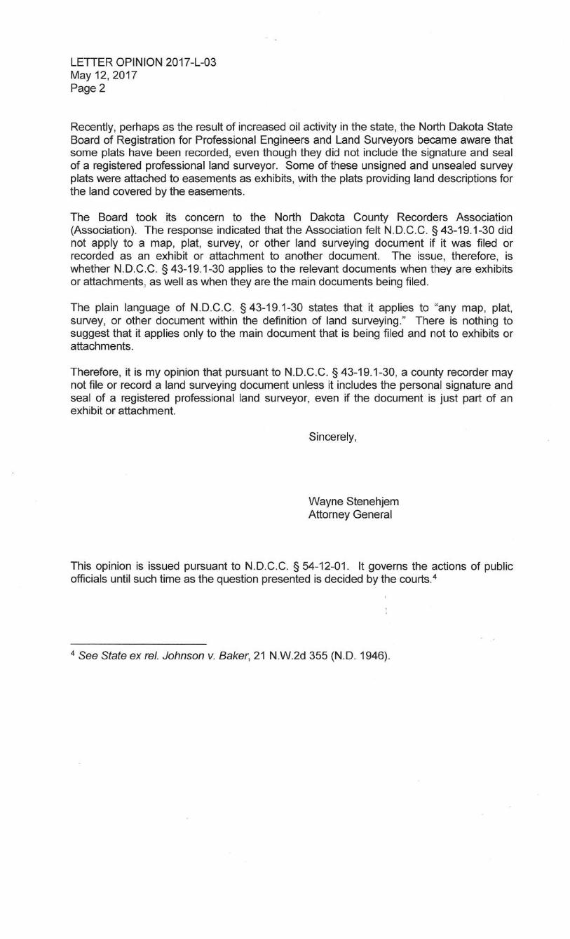
3.35 EXHIBIT
An object or statement produced before a court of law and referred to while giving evidence. An exhibit attached to a map, plat, survey, or other land surveying document filed for record falls into the definition of land surveying. These documents may not be filed or recorded unless it includes the personal signature and seal of a registered professional land surveyor, even if the document is just part of an exhibit or attachment. Pursuant to N.D.C.C. 43-19.1-30 according to AG Letter Opinion 2017-L-03.
C HA P TER 4 PA GE 2 5
Manual of Practice for Land Surveying in North Dakota
4 MONUMENTS AND COORDINATE SYSTEMS 4.1 GENERAL
This section provides guidelines for working with monuments and coordinate systems.
4.1.1 Monumentation Every boundary survey performed in North Dakota shall be monumented, or witness monumented, at all boundary corner locations. All corners shall be marked with a physical monument of a type or character and set in a manner providing a degree of permanency consistent with that of the local terrain and physical features. Monuments set by a Surveyor shall be made of durable material and should include an element that makes it possible to detect the monument by means of some device for finding ferrous or magnetic objects. Where possible, monuments set by a Surveyor shall bear an identification of the Surveyor by his or her Land Surveyor registration number. The minimum requirements for monuments set is set forth in NDCC 47-20.1-10. In the event it is not practical to set a monument of minimum requirements, monuments may be any of a large assortment of markers including iron pipes, cast concrete, cut stone, cast iron, iron rods or pins, chiseled crosses, survey mag or PK type masonry nails, etc. Note: Wood stakes shall not be used as permanent monuments. Also, small rods and masonry nails are to be used only in such cases in which it is impossible to set more substantial monuments. Examples of acceptable monuments are: • Steel re-bar: 5/8" diameter or larger, 18" or longer.
• Steel pipe: 3/4" inside diameter or larger, 18" or longer.
• Concrete or stone markers: 4" in diameter or 4" square, 18" or longer
and buried in the ground with rebar embedded in the concrete to allow for detection by a locator.
• A drill hole, or a scribed or chiseled mark, in existing concrete or stone.
• A survey masonry PK type spike/nail in pavement, etc.
• Stainless steel or aluminum washers set with brass or aluminum nails
with RLS number stamped on top. (Usually used in roadways or walkways where iron monuments cannot be driven properly).
C HA P TER 4 PA GE 2 6
Manual of Practice for Land Surveying in North Dakota
• Only one RLS number stamped per monument. Witness monumentation refers to the setting of an offset corner on the boundary line when it is not possible or practical to set the actual corner monument. For example, in business sections of urban areas, buildings may be erected on the property line. In such cases, chiseled crosses could be set on the extension of the lot lines at a convenient distance from the true corner and labeled W.C. with a distance to the corner. Reference monument refers to the setting of an offset monument not on the boundary line, with a cap referencing the distance to the actual corner and labeled R.M. It is recommended all monuments be prominently marked by the Surveyor in such a manner as to enable the client to easily find the monument. The markings should be appropriate to the conditions and vegetation cover and may range from paint on pavement with a mason nail in urban areas to steel fence posts in rural areas. We also suggest the Surveyor caution the client on the value and importance of the boundary monuments and recommend various methods whereby they can be protected and preserved. If it is not practical to set a monument at all, the record shall indicate the corner is not marked or monumented and why.
The NDSPLS has adopted the following as stated in NDCC 47-20.1-10. Minimum corner requirements. The registered Land Surveyor establishing or rehabilitating corner markers shall place as a minimum acceptable marker, a durable ferromagnetic monument not less than eighteen inches [45.72 centimeters] in length and not less than one-half inch [12.7 millimeters] in sectional dimension driven to a survey elevation depth to which is affixed a cap bearing the center point and the registered Land Surveyor's certificate number firmly impressed thereon. The NDSPLS has adopted the following as stated in NDCC 47-20.1-11. Corner records to be certified. No corner record shall be filed unless the same is signed by a registered Land Surveyor and stamped with the Surveyor's seal.

C HA P TER 4 PA GE 2 7
Manual of Practice for Land Surveying in North Dakota
4.1.2 Coordinates The NDSPLS has adopted the following as stated in NDCC 47-20.2-01. North Dakota coordinate system zones defined. The systems of plane coordinates which have been established by the national oceanic and atmospheric administration national ocean survey/national geodetic survey or its successors for defining and stating the geographic positions or locations of points on the surface of the earth within this state are, as of July 1, 1989, to be known and designated as the North Dakota coordinate system of 1927 and the North Dakota coordinate system of 1983. For the purpose of the use of these systems, the state is divided into a north zone and a south zone: 1. The area now included in the following counties constitutes the north
zone: Divide, Williams, McKenzie, Mountrail, Burke, Renville, Ward, McLean, Bottineau, McHenry, Sheridan, Pierce, Rolette, Towner, Benson, Wells, Foster, Eddy, Ramsey, Cavalier, Pembina, Walsh, Nelson, Grand Forks, Griggs, Steele, Traill.
2. The area now included in the following counties constitutes the south
zone: Dunn, Golden Valley, Slope, Bowman, Adams, Hettinger, Stark, Mercer, Oliver, Morton, Grant, Sioux, Emmons, Burleigh, Kidder, Logan, McIntosh, Stutsman, Barnes, LaMoure, Dickey, Cass, Ransom, Sargent, Richland.
The NDSPLS has adopted the following as stated in NDCC 47-20.2-02. North Dakota coordinate system names defined. As established for use in the north zone, the North Dakota coordinate system of 1927 or the North Dakota coordinate system of 1983 is named, and in any land description in which it is used it must be designated the North Dakota coordinate system of 1927, north zone, or the North Dakota coordinate system of 1983, north zone. As established for use in the south zone, the North Dakota coordinate system of 1927 or the North Dakota coordinate system of 1983 is named, and in any land description in which it is used it must be designated the North Dakota coordinate system of 1927, south zone, or the North Dakota coordinate system of 1983, south zone. The NDSPLS has adopted the following as stated in NDCC 47-20.2-03. North Dakota coordinate system defined. The plane coordinate values for a point on the earth's surface, used in expressing the geographic position or location of such point in the appropriate zone of this system, shall consist of two distances, expressed in United States survey feet [meters] and decimals of a foot [meter] when using the North Dakota coordinate system of 1927.

C HA P TER 4 PA GE 2 8
Manual of Practice for Land Surveying in North Dakota
One of these distances, to be known as the X-coordinate, shall give the position in an east-west direction; the other, to be known as the Y-coordinate, shall give the position in a north-south direction. These coordinates shall be made to depend upon and conform to plane rectangular coordinate values for the monumented points of the North American horizontal geodetic control network as published by the national ocean survey/national geodetic survey, or its successors, and the plane coordinates which have been computed on the systems defined in this chapter. Any such station may be used for establishing a survey connection to either North Dakota coordinate system. For the purposes of converting coordinates of the North Dakota coordinate system of 1983 from meters to feet, the international survey foot must be used. The conversion factor is: one foot equals 0.3048 meter exactly. The NDSPLS has adopted the following as stated in NDCC 47-20.2-04.
Federal and state coordinate description same tract – Federal precedence. Whenever coordinates based on the North Dakota coordinate system are used to describe any tract of land which in the same document is also described by reference to any subdivision, line, or corner of the United States public land surveys, the description by coordinates must be construed as supplemental to the basic description of each subdivision, line, or corner contained in the official plats and field notes filed of record, and, in the event of any conflict, the description by reference to the subdivision, line, or corner of the United States public land surveys prevails over the description by coordinates, unless the coordinates are upheld by adjudication, at which time the coordinate description will prevail. This chapter does not require any purchaser or mortgagee to rely on a description, any part of which depends exclusively upon the North Dakota coordinate system, unless the description has been adjudicated as provided in this section. The NDSPLS has adopted the following as stated in NDCC 47-20.2-05. North Dakota coordinate system origins defined. 1. For the purposes of more precisely defining the North Dakota
coordinate system of 1927, the following definitions by the United States coast and geodetic survey are adopted:
a. The North Dakota coordinate system of 1927, north zone, is a
Lambert conformal conic projection of the Clarke spheroid of 1866, having standard parallels at north latitudes, forty-seven degrees twenty-six minutes and forty-eight degrees forty-four minutes along which parallels the scale shall be exact. The origin of coordinates is at the intersection of the meridian one

C HA P TER 4 PA GE 2 9
Manual of Practice for Land Surveying in North Dakota
hundred degrees thirty minutes west of Greenwich and the parallel forty-seven degrees zero minutes north latitude. This origin is given the coordinates: x = 2,000,000 feet [609.6 kilometers], and y = 0 feet [0 kilometers].
b. The North Dakota coordinate system of 1927, south zone, is a
Lambert conformal conic projection of the Clarke spheroid of 1866, having standard parallels at north latitudes forty-six degrees eleven minutes and forty-seven degrees twenty-nine minutes along which parallels the scale shall be exact. The origin of coordinates is at the intersection of the meridian one hundred degrees thirty minutes west of Greenwich and the parallel forty-five degrees forty minutes north latitude. This origin is given the coordinates: x = 2,000,000 feet [609.6 kilometers], and y = 0 feet [0 kilometers].
2. For the purposes of more precisely defining the North Dakota
coordinate system of 1983, the following definition by the national ocean survey/national geodetic survey is adopted:
a. The North Dakota coordinate system of 1983, north zone, is a
Lambert conformal conic projection of the North American datum of 1983, having standard parallels at north latitude of forty-seven degrees twenty-six minutes and forty-eight degrees forty-four minutes along which parallels the scale shall be exact. The origin of coordinates is at the intersection of the meridian one hundred degrees thirty minutes west of Greenwich and the parallel forty-seven degrees zero minutes north latitude. This origin is given the coordinates: x = 600,000.0000 meters, and y = 00.0000 meters.
b. The North Dakota coordinate system of 1983, south zone, is a
Lambert conformal conic projection of the North American datum of 1983, having standard parallels at north latitude of forty-six degrees eleven minutes and forty-seven degrees twenty-nine minutes along which parallels the scale shall be exact. The origin of coordinates is at the intersection of the meridian one hundred degrees thirty minutes west of Greenwich and the parallel forty-five degrees forty minutes north latitude. This origin is given the coordinates: x = 600,000.0000 meters, and y = 00.0000 meters.

C HA P TER 4 PA GE 3 0
Manual of Practice for Land Surveying in North Dakota
The NDSPLS has adopted the following as stated in NDCC 47-20.2-06. North Dakota coordinate system - Use of term. The use of the North Dakota coordinate system of 1927 north zone or south zone or the North Dakota coordinate system of 1983 north zone or south zone on any map, report of survey, or other document must be limited to coordinates based on the North Dakota coordinate systems as defined in this chapter. The map, report, or document must include a statement describing the standard of accuracy, as defined by the national ocean survey/national geodetic survey, maintained in developing the coordinates shown therein. The coordinates must be established in conformity with these standards: 1. No coordinates based on the North Dakota coordinate system,
purporting to define the position of a point on a land boundary, may be presented to be recorded in any public records or deed records unless the point is connected to a triangulation or traverse station established in conformity with the standards prescribed in this chapter.
2. Coordinate values used in land descriptions under this section must
be certified by a duly registered Land Surveyor under the laws of this state.
Properly conducted OPUS observations and solutions by NGS can be used to tie public land system corners for record other than being connected to a triangulation or traverse station established in conformity with the standards prescribed in this chapter.
4.2 STANDARDS
Accuracy. The surveyor must use the correct procedure to attain the horizontal and/or vertical control accuracy demanded of the survey project. The current National Geodetic Survey standards are a good reference for all types of geodetic control networks and boundary works.
• Positional Accuracy for Cadastral Control is less than 0.164 US feet in the 95% confidence circle.
• Positional Accuracy for Cadastral Measurements is less than 0.328 US feet in the 95% confidence circle.
4.3 ORDER OF IMPORTANCE
The law provides that the corners marked during the process of an original survey shall forever remain fixed in position, even disregarding technical errors that may have passed undetected before acceptance of the survey.
C HA P TER 4 PA GE 3 1
Manual of Practice for Land Surveying in North Dakota
Major importance is given to evidence relating to the original position of the corner. In fact, it is given far greater weight than the record relating to bearings and lengths of lines. The corner monument and its accessories constitute direct evidence of the position of the corner.
1. The boundaries of the public lands, when approved and accepted, are
unchangeable. 2. The original township, section, and quarter section corners must stand
as the true corners which they were intended to represent, whether in the place shown by the field notes or not.
3. Quarter-quarter-section corners not established in the original survey
shall be placed on the line connecting the section and quarter-quarter section corners, and midway between them, except on the last half mile of section lines closing on the north and west boundaries of the township, or on the lines between fractional or irregular sections.
4. The center lines of a section are to be straight, running from the quarter-
section corner on one boundary to the corresponding corner on the opposite boundary.
5. In fractional sections where no opposite corresponding quarter-section
corner has been or can be established, the center line must be run from the proper quarter-section corner as nearly in a cardinal direction to the meander line, reservation, or other boundary of such fractional section, as due parallelism with the section boundary will permit.
6. All dependent resurveys are retracement and establishment of the line
of the original survey. The dependent resurveys are to be referenced to the original Government Land Office (GLO)-approved official surveys and all approved supplemental surveys and the best available evidence of the true position of the original corners. We suggest Surveyors review and be familiar with chapters V and VI of the BLM Manual of Surveying Instructions (2009 or most current revision).
4.4 PUBLIC RECORDS AND AVAILABILITY LOCATIONS
Original General Land Office (GLO) records of plats and notes are available from the following sources:
• North Dakota State Water Commission in Bismarck or online at http://survey.swc.nd.gov/.
• Local county recorder’s office or on line at http://ndrin.com. • Local city government office for any records or documents in its
holdings.
C HA P TER 4 PA GE 3 2
Manual of Practice for Land Surveying in North Dakota
• Local county engineer’s office for records, plats, maps, and documents. • North Dakota DOT R/W Surveys and Plats. • Other Public Records Available. (For more information, see the
subhead “Types” under the chapter “Land Descriptions,” elsewhere in this document as stated in Chapter 6.2.1).
• US Army Corps Engineers Missouri River take lines and plats. • USBOR office in Carrington, ND for McClusky Canal Plats. • Lower Yellowstone Irrigation plats- LYREA Office, Sidney, MT. • Basin Electric power line mosaics easement plats, Bismarck, ND. • NDDOT archives room at NDDOT building, Bismarck, ND. • US Fish and Wildlife Refuge and WPA WMA plats. At refuge HQ near
project site. • Well Plats available on NDIC’s website. • State Lands Surveys on line. • Rail Road Plats (most held at NDDOT). • Indian Reservation surveys, plats, boundaries, and information. • USFWS-Division of Realty, Denver, CO. • USDA Forest Service Office, Dickinson, ND.
4.5 EVIDENCE
Evidence proves a fact directly without presumption or inference. It can be anything legally submitted to a competent tribunal as a means of ascertaining the truth of any alleged matter of fact under investigation before it, means of making proof, or a medium of proof. Evidence can be material objects such as physical monuments. The NDSPLS has adopted the following as stated in NDCC 64-02-09 Standards of weights and measures. The commission shall maintain the following standards of weights and measures, which must conform to the United States standards:
• One Surveyor's chain, sixty-six United States survey feet in length. • One yard [in meters, equal to 36 divided by 39.37] measure. • One United States survey foot [in meters, equal to 12 divided by
39.37] measure and one international foot [exactly .3048 meters] measure.
• One inch [25.40 millimeters] measure. • One one hundred pound [45.36 kilograms] weight. • One fifty pound [22.68 kilograms] weight. • One twenty-five pound [11.34 kilograms] weight. • One ten pound [4.54 kilograms] weight. • One one pound [.4536 kilogram] weight. • One half-pound [.2268 kilogram] weight.
C HA P TER 4 PA GE 3 3
Manual of Practice for Land Surveying in North Dakota
• One quarter-pound [.1134 kilogram] weight. • One one-eighth of a pound [.0567 kilogram] weight. • One one-sixteenth of a pound [.0284 kilogram] weight or one ounce
[28.35 grams] weight. • One set of apothecaries' weights from one pound [.4536 kilogram] to
one grain [64.80milligrams] and one set of troy weights from one pound [.3732 kilogram] to one grain [64.80 milligrams].
• Other weighing and measuring devices necessary to test and calibrate standards.
These standards are the legal standards of weights and measures for this state and must be used for testing the secondary standards used to test weighing or measuring devices.
C HA P TER 5 PA GE 3 4
Manual of Practice for Land Surveying in North Dakota
5 SURVEY CORNER RECORDS Once a Land Surveyor locates a corner, a record must be certified and filed. This chapter provides guidance for both completing new and finding previously filed corner records.
The NDSPLS has adopted the following as stated in NDCC 47-20.1-01. SURVEY AND CORNER RECORDATION ACT Purpose. It is the purpose of this chapter to protect and perpetuate public land survey corners and information concerning the location of such corners by requiring the systematic establishment of monuments and recording of information concerning the marking of the location of such public land survey corners and to allow the systematic location of other property corners, thereby providing for property security and a coherent system of property location and identification of ownerships, and thereby eliminating the repeated necessity for reestablishment and relocations of such corners where once they were established and located, and, to authorize any registered Land Surveyor to locate, erect, maintain, record and perpetuate landmarks, monuments, section corners, quarter corners, meander lines or boundary lines heretofore or hereafter established. The NDSPLS has adopted the following as stated in NDCC 47-20.1-02. Definitions. Except where the context indicates a different meaning, terms used in this chapter shall be defined as follows:
1. "Accessory Corner" means any exclusively identifiable physical object whose spatial relationship to the corner is recorded. Accessories may be bearing trees, bearing objects, monuments, reference monuments, line trees, pits, mounds, charcoal filled bottles, steel or wooden stakes or other objects.
2. "Corner,” unless otherwise qualified, means a property corner, or a
property controlling corner, or a public land survey corner, or any combination of these.
3. "Monument" means an accessory that is presumed to occupy the
exact position of a corner. 4. "Practice of Land Surveying" means the assuming of responsibility
for the surveying of land for the establishment of corners, lines, boundaries, and monuments, the laying out and subdivision of land, the defining and locating of corners, lines, boundaries, and monuments after they have been established, the survey of land

C HA P TER 5 PA GE 3 5
Manual of Practice for Land Surveying in North Dakota
areas for the purpose of determining the topography thereof, the making of topographical delineations, and the preparing of maps and accurate records thereof, when the proper performance of such services requires technical knowledge and skill.
This Practice of Land Surveying has now been superseded by the new definition under NDCC Chapter 43-19.1-02 (8).
5. "Property Controlling Corner" means a public land survey corner,
or any property corner, which does not lie on a property line of the property in question, but which controls the location of one or more of the property corners of the property in question.
6. "Property Corner" means a geographic point on the surface of the
earth, and is on, a part of, and controls a property line. 7. "Public Land Survey Corner" means any corner actually
established and monumented in an original survey or resurvey used as a basis of legal description for issuing a patent for land to a private person from the United States government.
8. "Reference Monument" means a special monument that does not
occupy the same geographical position as the corner itself, but whose spatial relationship to the corner is recorded, and which serves to witness the corner.
9. "Registered Land Surveyor" means a Surveyor who is registered to
practice land surveying under chapter 43-19.1 regulating the registration and practice of professional engineering and Land Surveyors, or who is authorized under said chapter to practice land surveying as defined herein.
The NDSPLS has adopted the following as stated in NDCC 47-20.1-03. Filing of corner record required. A Surveyor shall complete, sign, stamp with the Surveyor's seal, and file with the Recorder of the county where the corner is situated a written record of corner establishment or restoration to be known as a "corner record" for every public land survey corner and accessory to such corner which is established, reestablished, monumented, remonumented, restored, rehabilitated, perpetuated, or used as control in any survey by such Surveyor, and within ninety days thereafter, unless the corner and its accessories are substantially as described in an existing corner record filed in accord with the provisions of this chapter.
C HA P TER 5 PA GE 3 6
Manual of Practice for Land Surveying in North Dakota
The NDSPLS has adopted the following as stated in NDCC 47-20.1-04. Filing permitted as to any property corner. A registered Land Surveyor may file such corner record as to any property corner, property controlling corner, reference monument, or accessory to a corner.
5.1 PUBLIC RECORDER
The following describes how the Public Recorder of the county containing a corner manages the recording process:
Note. Certifying the corner record is the responsibility of the Land Surveyor. The Recorder will not file a corner record until it is first signed by a registered Land Surveyor and stamped with the Surveyor's seal.
1. The Recorder receives the completed corner record and preserves it
in a hardbound book. The books are numbered in numerical order as filled.
2. The Recorder numbers the forms in numerical order as filed. 3. The Recorder places the book and page number in which the said
corner record is filed near that same corner on a cross-index plat, which the Recorder provides for such purpose.
4. The Recorder makes these records available for public inspection
during all usual office hours.
Official corner record. When a corner has been established and filed, that corner record enters the official record and becomes available to all state and federal government agencies without cost; however, the Recorder may charge a reasonable fee for furnishing certified copies of the official record to others.
5.1.1 Acknowledgments
The NDSPLS has adopted the following as stated in NDCC 43-19.1-30 Duties of recorder. It is unlawful for the recorder of any county or any county or any proper public authority to file or record any map, plat, survey, or other document with the definition of land surveying which does not have impressed thereon and affixed thereto the personal signature and seal of a registered professional land surveyor by whom the map, plat, survey, or other document was prepared.

C HA P TER 5 PA GE 3 7
Manual of Practice for Land Surveying in North Dakota
Under Chapter NDCC 47-19 Record Title specifically 47-19-02 Instruments entitled to record without acknowledgment. 47-19-02. Instruments entitled to record without acknowledgment. The following instruments may be recorded without acknowledgment or further proof: 1. An instrument issued by an agency, bureau, department, or the judiciary of the United States, this state or a political subdivision of this state, or an Indian tribe recognized by the United States department of the interior. An instrument includes a contract or agreement that is entered by one of these governmental entities that contract or agreement is deemed to have been issued by the entity. 2. An instrument certified by an agency, bureau, department, or the judiciary of the United States or a foreign government, a state of the United States or a political subdivision of a state, or an Indian tribe recognized by the United States department of the interior. 3. A lis pendens or other instrument that is signed by an attorney at law licensed to practice law in this state which bears the attorney's identification number issued by the state board of law examiners. 4. An affidavit that bears a jurat or verification upon oath or affirmation. 5. A Uniform Commercial Code financing statement under title 41. 6. A plat signed by a land surveyor registered in this state. 40-50.1-15. Filing and recording of surveyor's certificate. The recorder of the county in which the land platted or subdivided is located shall accept each certificate for filing and recording upon payment of a fee commensurate with the length of the certificate. Neither witnesses nor an acknowledgment is required on any such certificate, but it must be signed by the registered land surveyor and must include a statement that the signing surveyor holds valid registration in this state. The recorder shall make suitable notations on the record of the plat or subdivision to which the certificate refers to direct the attention of anyone examining the plat or subdivision to the record of that certificate. No such certificate has the effect of destroying or changing vested rights acquired based on an existing plat or subdivision despite errors, defects, or omissions.

C HA P TER 5 PA GE 3 8
Manual of Practice for Land Surveying in North Dakota
5.2 REHABILITATION The Land Surveyor must rehabilitate monuments. In every case where a corner record of a public land survey corner is required to be filed under the provisions of this chapter, the Surveyor must reconstruct or rehabilitate the monument of such corner and accessories to such corner, so it remains as permanent a monument as is reasonably possible and so the same may be reasonably expected to be located in the future.
5.3 RESPONSIBILITY
Corner records to be certified. No corner record shall be filed unless the same is signed by a registered Land Surveyor and stamped with the Surveyor’s seal. Only one registered Land Surveyor’s stamp, seal, and signature per corner record document filed form.
Other corner records may be filed for the same corner but must be on a separate corner document form.

C HA P TER 6 PA GE 3 9
Manual of Practice for Land Surveying in North Dakota
6 LAND DESCRIPTIONS 6.1 WRITING PRINCIPLES
In general, we recommend Land Surveyors follow the principles outlined in Writing Legal Descriptions by Gurdon Wattles: When the surveyor, in the course of performing measurements, finds that he is unable to reconcile those implied by the record with those disclosed by evidence in the field, it is at this juncture that the surveyor is called upon to exercise his/her skill in the art of land surveying. What is implied by the apparent discrepancies in the field evidence versus the written record are set forth. At all times the classic precept of following in the footsteps of the original surveyor receives its due. The concept of locatability of a description is paramount. To minimize ambiguity and reduce discrepancies is job one when writing a good description. The NDCC also includes requirements as follows: The NDSPLS has adopted the following as stated in NDCC 47-19-03.1. Deeds and contracts for deeds to include name and address of drafter of legal description. (otherwise known as the Scrivener Law). The recorder may not record a deed or contract for deed containing a metes and bounds legal description which affects the title to or possession of real property that otherwise may be recorded under this chapter unless the name and address of the individual who drafted the legal description contained in the deed or contract for deed appears on the instrument in a legible manner. A deed or contract for deed complies with this section if it contains a statement substantially in the following form: "The legal description was prepared by ________________ (name) ________________ (address) or obtained from a previously recorded instrument." This section does not apply to any instrument executed before January 1, 2000, or any instrument executed or acknowledged outside the state. The validity and effect of the record of any instrument in a recorder's office may not be lessened or impaired by the fact the instrument does not contain the statement required by this section.
6.1.1 Writing or Reading Legal Descriptions
When you write or read legal descriptions, determine the items that have control or authority over other conditions. Follow the established order of superiority of calls or elements, known as the rules of construction. Here is a general summary of those rules: • Monuments, natural or artificial, or legal referring to matters of record
or some combination of these kinds of monuments which are recited.
C HA P TER 6 PA GE 4 0
Manual of Practice for Land Surveying in North Dakota
The recital of these in descriptions adds to the supremacy of them over other conditions.
• Monuments, physical or record, not recited but disclosed by reference to maps and other record documents.
• Recital of a boundary record, such as reference to a map or deed. • Recited distance and/or bearing ties to record corners or lines not on
the boundary of this property. • Distances on this boundary, without ties to any of the foregoing. • Bearings on the boundary or angles between lines, without ties. • Areas stated as a corollary or an addendum to the description.
6.2 RECORD MAPS A record map should provide a representation on a plane surface, at an established scale, of the physical features (natural, artificial, or both) of a part of the Earth’s surface, by the use of signs and symbols, and with the method of orientation indicated. The type of information the record map conveys is described in adjective form to distinguish the map from maps of other types. A map should contain a record of the projection on which it is constructed. (See also Chapter 4.4 Public Records and Availability Locations)
6.2.1 Types The following are types of record maps:
• Official City, County, and State area location maps, plats, and R/W documents and notes. • General Location utility maps. • Federally and State-owned lands maps. • Public and privately-owned lands maps. • Resource location maps. • Restricted area maps. • Water locations maps of rivers, lakes, streams, and creeks.
6.3 CERTIFICATIONS AND STATEMENTS
Requirements for certifications and statements regarding surveys, parts, and uses are found throughout this manual, see especially in the section Surveys. In addition to monumentation, you must provide a certificate assuring the monuments have been accurately set in accordance with law. Example: I,[surveyor’s name], hereby certify I am a Licensed Land Surveyor in the state of North Dakota, that this survey was made by me or under my direction and supervision between [name] and [name] and that the survey is true and complete as shown, that all monuments, and marks set, together

C HA P TER 6 PA GE 4 1
Manual of Practice for Land Surveying in North Dakota
with those found, are of the character and occupy the positions shown thereon, and are sufficient to enable this survey to be retraced. Signed ____________________________ Date ____________________ On every survey plat the surveyor should certify as to what he/she has done. The form used varies, depending on its purpose. If there is not a certification, statement, or a narrative describing what the surveyor has done on the face of the plat or document, and the surveyor has stamped and sealed the document, it is understood everything on the face of that document is correct and to the surveyors satisfaction, and the surveyor has now accepted responsibility for all of that information. The surveyor needs to make certain what distances are shown on the plat and legal description. It is preferred to use ground distances on all plats and legal descriptions to keep recording documents later in harmony with other previously filed records. If grid distances are used on the plat and legal description, it must be clearly stated, and all proper meta data needs to be included on both the plat and the body of the legal description.

C HA P TER 7 PA GE 4 2
Manual of Practice for Land Surveying in North Dakota
7 SUBDIVISION OF SECTIONS Several laws and other resources provide guidance on subdivision of sections. The rules and methods for accomplishing this task are in Chapter III of the BLM 2009 Manual of Surveying Instructions, or current manual, and are used and applied in North Dakota rules.
7.1 PLATTING LAWS AND REGULATIONS
The NDSPLS has adopted the following as stated in NDCC 11-33.2-01.
Subdivision defined. For the purposes of this chapter, unless the context otherwise requires, "subdivision" means the division of a lot, tract, or parcel of land, creating one or more lots, tracts, or parcels for the purpose, whether immediate or future, of sale or of building development, and any plat or plan which includes the creation of any part of one or more streets, public easements, or other rights of way, whether public or private, for access to or from any such lot, tract, or parcel, and the creation of new or enlarged parks, playgrounds, plazas, or open spaces. The NDSPLS has adopted the following as stated in NDCC 11-33.2-02. County power to regulate subdivision. For the purpose of promoting health, safety, morals, public convenience, general prosperity, and public welfare, the board of county commissioners of any county is hereby empowered to regulate and restrict within the county the subdivision of land. This chapter shall not serve to invalidate any ordinance, resolution, regulation, decision, plat approval, or other action taken or adopted, by a board of county commissioners or county planning commission, prior to or subsequent to July 1, 1981, which regulates or otherwise affects the subdivision of land, except that, subsequent to July 1, 1981, the provisions of section 11-33.2-12 shall apply to any county requiring plat approval as a prerequisite to the subdivision of land. The NDSPLS has adopted the following as stated in NDCC 40-50.1-01. Laying out townsites, additions, and subdivisions - Survey and plat required - Contents of plat. Any person desiring to lay out a townsite, an addition to a townsite, or a subdivision of land shall cause the land to be surveyed and a plat made of the land. The written plat must comply with the following:
1. The plat must describe particularly and set forth all the streets, alleys,
and public grounds, and all outlots or fractional lots within or adjoining the townsite or jurisdiction, together with the names, widths, courses,

C HA P TER 7 PA GE 4 3
Manual of Practice for Land Surveying in North Dakota
boundaries, and extent of all such streets, alleys, and public grounds, and giving the dimensions of all lots, streets, alleys, and public grounds.
2. All lots and blocks, however designated, must be numbered in
progressive numbers and their precise length, width, and area be stated on the map or plat. The streets, alleys, or roads which divide or border the lots must be shown on the map or plat.
3. The plat must indicate that all outside boundary monuments have been
set and indicate those interior monuments that have been set. There must be shown on the plat all survey and mathematical information, including bearings and distances, and data necessary to locate all monuments and to locate and retrace all interior and exterior boundary lines appearing on the plat. All interior lot lines and exterior boundary lines of the plat must be correctly designated on the plat and show bearings on all straight lines, or angles at all angle points, and central angle, radius, and arc length for all curves. All distances must be shown between all monuments as measured to the hundredth of a foot [0.3048 centimeter]. All lot distances must be shown on the plat to the nearest hundredth of a foot [0.3048 centimeter] and all curved lines within the plat must show central angles, radii, and arc distances. A north arrow and the scale of the plat must be shown on the plat. The scale must be of a dimension that the plat may be easily interpreted. If a curved line constitutes the line of more than one lot in any block of a plat, the central angle for that part of each lot on the curved line must be shown.
4. Ditto marks may not be used on the plat for any purposes. 5. If a river, stream, creek, or lake constitutes a boundary line within or of
the plat, a survey line must be shown with bearings or angles and distances between all angle points and their relation to a waterline, and all distances measured on the survey line between lot lines must be shown, and the survey line shown as a dashed line.
6. The unadjusted outside boundary survey and the plat survey data must
close by latitude and departure with an error that does not exceed one part in ten thousand parts.
7. All rivers, streams, creeks, lakes, and all public highways, streets, and
alleys of record must be correctly located and plainly shown and designated on the plat.
8. The names and adjacent boundary lines of any adjoining platted lands
must be dotted on the plat.

C HA P TER 7 PA GE 4 4
Manual of Practice for Land Surveying in North Dakota
9. The scale must be shown graphically, and the basis of bearings must be shown. The plat must be dated as to the completion of the survey and preparation of the plat.
10. The purpose of any easement shown on the plat must be clearly stated.
Building setbacks may not be shown on the plat. 11. Any plat which includes lands abutting upon any lake, river, or stream
must show a contour line denoting the present shoreline, water elevation, and the date of survey. If any part of a plat lies within the one-hundred-year floodplain of a lake, river, or stream as designated by the state engineer or a federal agency, the mean sea level elevation of that one-hundred-year flood must be denoted on the plat by numerals. Topographic contours at a two-foot [60.96-centimeter] contour interval referenced to mean sea level must be shown for the portion of the plat lying within the floodplain. All elevations must be referenced to a durable benchmark described on the plat with its location and elevation to the nearest hundredth of a foot [0.3048 centimeter], which must be given in mean sea level datum.
Reference to the vertical datum of NGVD29 or NAVD 88 is the preferred vertical use today. If using GPS to measure the vertical datum it is also advised to state the Geoid model used in those measurements.
7.2 PROCEDURES-REFERENCES
See also the BLM Manual of Surveying Instructions 2009 or the current BLM manual. See also Restoration of Lost or Obliterated Corners & Subdivision of Sections BLM 1883-1974.

C HA P TER 8 PA GE 4 5
Manual of Practice for Land Surveying in North Dakota
8 SURVEYS 8.1 BOUNDARY SURVEYS
A boundary survey establishes or re-establishes a boundary line on the ground and/or obtains data for constructing a map or plat showing a boundary line. This falls under the category of Practice of Land Surveying. You can find more about boundary surveys, specifically platting irregular boundaries, in the Index under Platting Irregularities.
8.2 SURVEY STANDARD
A survey standard is a survey that, in scale, accuracy, and content, satisfies criteria prescribed for such a survey by a competent authority.
8.2.1 Accuracy Standards The surveyor must use the correct procedure to attain the horizontal and/or vertical control accuracy demanded of the survey project.
Accuracy standards were issued in 1998 by the Federal Geodetic Control Subcommittee (FGCS) to replace the accuracy standards issued in 1984 and 1988 by the FGCC Control Committee. Accuracies should be calculated separately for horizontal, ellipsoid, and orthometric height components according to the tables listed in the Definitions of Surveying and Mapping ACSM 2005. Also see Appendix C of this same publication for the National Standard for Spatial Data Accuracy.
8.3 AUDITORS SURVEY/PLAT
Per NDCC 57-02-39, the county auditor has the authority to request a survey to be made and a plat of said survey to be placed on record for any tract of land that is divided into irregular shapes that can only be described by a metes and bounds description. For more on platting auditor/irregular lots, see Platting Irregularities in the Index.
8.4 PROPERTY SURVEYS
A property survey is a record of property lines, easements, and land placement. It may include cadastral, location, lot, improvement, and a number of other types of surveys. It is a survey that is made to establish or to re-establish a boundary line on the ground or to obtain data for constructing a map or plat showing a boundary line.

C HA P TER 8 PA GE 4 6
Manual of Practice for Land Surveying in North Dakota
8.4.1 Classification of Property Surveys
8.4.1.1 City Lot Survey Recommendations (See Exhibits 13 & 14 for examples)
A detailed lot survey exhibit must be submitted with each application for new construction and addition to an existing structure. Lot survey exhibits must include the following information:
• General information:
o Name of property owner or builder o Street address and legal description (Subdivision, Lot, and Block)
of the development site o North direction indicator and scale o Date survey was prepared with Surveyor’s seal and signature
• Property Information: o Location and dimensions of all surveyed property boundary pins o Lot dimensions and area in square feet o Dimension, location, and description of all easements o Location and dimensions of driveway, road approach, non-access
lines, and street names o Location and dimensions of proposed and existing structures
(Delineate proposed construction from existing) o Floodplain and floodway boundary lines; if applicable o Actual and required building setbacks o Location of light poles, junction boxes, hydrants, storm inlets, and
utility boxes in the right of way • Properties located in the City.
o The location of septic tank, drain field, well, public water service, and significant topographical features should be identified for properties located in the City.
8.4.1.2 Possible Additional Required Permits, Applications and Review 8.4.1.2a Road Approach Permit
The County Engineer is responsible for issuing road approach permits for properties located outside city limits. A copy of an approved road approach permit should be submitted to the City Building Inspections Division with each residential permit application for a project located outside the city limits. Building permits usually will not be issued without an approved road approach permit.

C HA P TER 8 PA GE 4 7
Manual of Practice for Land Surveying in North Dakota
8.4.1.2b Special Flood Hazard Area Review A Floodplain Development Application and supporting documentation must be submitted to the Floodplain Administrator before construction or development begins within any special flood hazard area. Please contact your Floodplain Administrator if you have questions about the floodplain development application process.
8.4.1.2c Site Plan Review
A site plan should be approved by the City Engineering Department before a building permit can be issued for the construction of a two-family dwelling, rowhouse, or townhouse located in the city. Please check with the city Engineering Department if you have questions about the site plan application and review process.
8.4.1.2d Erosion and Sediment Control Permit (ESC)
A detailed erosion and sediment control plan must be submitted to the Public Works Department. The erosion and sediment control plan should include locations and dimensions of all proposed land disturbing activities by phases, locations of all stockpile areas, locations and description of all best management practices (BMP), and a maintenance schedule for all BMP. Any contractor that performs land disturbance within city limits must obtain an ESC permit from the Storm Water Division of the city. Please contact the Public Works Department if you have questions about the erosion and sediment control permit process.
8.5 CADASTRAL SURVEYS
Cadastral surveys are the surveys of the public lands of the U.S., including retracement surveys for the identification and restoration of property lines. Cadastral relates land boundaries and subdivisions made to create units suitable for transfer or to define the limitations of title. This type of survey registers real property of a political subdivision with details of area, ownership, and value. See Index for more about the structure of a Cadastral survey report.
8.6 LOCATION SURVEYS
Location surveys are made in preparation for construction. They involve measurement of elevation, distance, and direction or angle, and staking on the ground of each detail of a design facility. Note the plans for an engineering project (road, canal, etc.) are prepared in the office from survey data obtained in the field. These plans then form a paper location and are the basis of the location survey.

C HA P TER 8 PA GE 4 8
Manual of Practice for Land Surveying in North Dakota
8.7 IMPROVEMENT SURVEYS Improvement location surveys depict on-site property improvements that have been proposed or record existing or recent improvements that have been made on a property. These surveys ensure improvements are within the boundary lines of the property and do not lie in setbacks or other rights-of-way or easements. Any reference distance ties to property boundaries from items located on these surveys are, by definition, the practice of land surveying and require a licensed surveyor in North Dakota to make those determinations.
8.8 CITY SURVEYS
City surveys typically include Lot and Elevation surveys. Plot plans are also related to City surveys. See the Index (Exhibit 2) for an example of a City plat or submittal checklist. (See 14.8 for checklist) (See Exhibits 13A, 13B and 14 for examples) Check with city managers, surveyors, or engineers to verify any special content requested on these types of surveys.
8.9 LOT SURVEYS
A residential lot survey is a type of city survey that maps a property showing its boundaries. Lot surveys show the relative location of a house, shed, fence, and other buildings or improvements on the property. Before new construction or improvements, such as additions, fences, or garages, are constructed, it is critical to review property lines and setbacks.
8.9.1 Common Steps for Lot Surveys
The local permitting process often indicates the level of survey detail required, but common steps include the following: 1. Research the parcel or tract legal descriptions and property lines. 2. Locate existing survey monumentation in the field. 3. Set missing lot corners and monuments for home owners review.
4. Prepare and draft a lot survey exhibit (may require the above information, together with proposed improvements for client and municipality review, if needed).
Note item 3 above falls into the category of the Practice of Land Surveying as per NDCC 43-19.1-02 (8) (see also the chapter “Definitions” in this manual). Therefore, a licensed land surveyor in North Dakota must review it.
Local permitting may also require the following:
• Lot dimensions

C HA P TER 8 PA GE 4 9
Manual of Practice for Land Surveying in North Dakota
• Legal description • Site address • Home owner or builders name • Setback lines with dimensions • Non-access control lines • Building footprint, proposed or existing, and driveway location and
dimension • Location of existing street light poles, junction boxes, hydrants,
storm sewer inlets and utility boxes • Other physical items on the property deemed pertinent to the
property
All lot survey exhibits must be stamped, dated, and signed by a licensed Professional Land Surveyor in North Dakota.
8.10 ELEVATION SURVEYS
An elevation survey is a type of survey that determines the elevation of an unknown point by referencing it to a known point elevation point called a benchmark, BM, or vertical control point on a known or published datum. The Surveyor measures the vertical difference between the two points and applies the proper values. This is done in topographic surveys and road surveys along with house and sewer construction projects.
8.10.1 Important Guidelines for Elevation Surveys
• North Dakota requires a licensed Professional Surveyor determine the elevation of the home or property in relation to the current flood elevation values and datum for that area of work.
• When completing an Elevation Survey, state the vertical datum being
used such as NGVD 29 or NAVD 88. When using GPS to measure the vertical distances it is also important to note the Geoid model being used.
8.10.2 Elevation Certificates
Elevation certificates can be of varying types according to the agency requesting them. These can be requested from the city, banks, title companies, county, tribal, state, or federal levels, and the information required on these certificates can vary from agency to agency. You must check with the agency requiring these certificates to determine the content. Usually, the agency has an example or copy of the information. As stated above, one of the most important requirements of this type of certificate is that you state the datum used for the vertical information (NGVD29 or
C HA P TER 8 PA GE 5 0
Manual of Practice for Land Surveying in North Dakota
NAVD88) and, for vertical measurements done with GPS, you state the Geoid model used.
8.10.3 FEMA Elevation Certificates
FEMA elevation certificates are used for flood information on the federal level and for flood insurance purposes. Some cities and counties have adopted these certificates for reference in the elevation certificate process. To get the most recent FEMA elevation certificate and instructions, go to https://www.fema.gov and look for form FEMA 81-31 and the instructions for it.
8.11 PLOT PLANS
A plot plan is an architecture, engineering, and/or landscape architecture plan drawing that shows the buildings, utility runs and locations, equipment layout, position of roads, and other constructions of an existing or proposed project site at a defined scale. When combined with a boundary survey, a plot plan should adhere to provisions of the regulatory agency, and to those provisions of "Boundary Surveys” that are not in conflict with the provisions of the regulatory agency. If a boundary survey is not performed and monuments are not placed, then the provisions of the regulatory agency apply. If reference or measurements are made to the property boundary line or lines, this falls under the definition of the practice of land surveying and must be done or supervised by a North Dakota licensed Professional Land Surveyor. Make sure the user understands the purpose and limitations of this type of plan. We suggest the words "THIS IS NOT A BOUNDARY SURVEY" appear prominently on the map.
8.12 RURAL SURVEYS
(See Certificate of Surveys (COS) and Irregular Tracts in the Index, as well as Auditors Lot surveys and Cadastral surveys in this chapter (pages 45 and 47). See also Outlots and Sublots in the chapter “Definitions.”)
8.13 MORTGAGE SURVEYS
Mortgage Inspection Report or Loan Report. NDSPLS hesitates to even list these types of documents in its Manual of Practice since neither the State or the North Dakota Board of Registration has adopted any standards for these types of works. This type of drawing is simply a sketch of, usually, a residence with more disclaimers than dimensions. Generally, the Surveyor prepares a report for the use of a specific client. It should be prominently labeled “Mortgage Inspection Report” and should not be designated as or construed as being a Land Boundary Survey.
C HA P TER 8 PA GE 5 1
Manual of Practice for Land Surveying in North Dakota
Some suggested wording should be similar to: “This Mortgage Inspection Report was prepared for (individual or firm). It is not a land or boundary survey plat, and it is not to be relied upon for the establishment of fence, building, or other future improvement lines. The linear and angular values shown on this sketch, if any, are based on record or deed information and have not been verified unless noted.”
Surveyor Location Report. This is sometimes referred to as a mortgage or loan survey. It briefly describes and shows the location of existing monuments, buildings, fences and other improvements on the property or possible encroaching improvements on adjoining properties. These reports show the location of easements or setback lines on the lot as determined from the recorded plat. This information should not be used for construction of new improvements or fences. This report is an inspection by a Professional Land Surveyor. Corner markers will not be set if missing.
Mortgage surveys are typically less detailed than lot surveys. However, they are still subject to a number of guidelines:
8.13.1 Mortgage Loan Survey Requirements 1. A Registered Land Surveyor must sign, stamp, and date the mortgage
loan survey. 2. All mortgage loan surveys should contain the following information:
• Title (mortgage loan survey). • North arrow accurately correlated to the courses shown on the
property lines. • Indication of basis of bearings or azimuths when used. • A numerical scale. • Date of survey. • Visible encroachments. • Land description of the property. • Land Surveyors certification.
3. Mortgage loan surveys may also contain the following information:
• Name of owner of the property or the name of the person who requested the inspection.
• A descriptive location of the property by township name, township and range, city, or county, in addition to the land description.
• Horizontal lengths of lines of the subject property wherein such lengths are the public record as in a deed or on a recorded plat.
• Legend. • Easements located in accordance with descriptions furnished or as
shown on a plat of record.

C HA P TER 8 PA GE 5 2
Manual of Practice for Land Surveying in North Dakota
• Lot and block numbers, and names of thoroughfares and waterways. • Dimensions of structures showing size and location together with
the type of construction, obvious use, and street address, if any. • All property corner monuments found and identified as to character. • Known boundary or description gaps or overlaps. Gaps and overlaps
should be dimensioned wherever possible. 8.14 CONDOMINIUM SURVEYS
A condominium survey includes a map and description of rights to land or space defined by state law and containing allocated interests, common elements, and independent use units. The form of ownership on these types of surveys are less than the whole. The fee ownership of separate portions of multistoried buildings by statute provides the mechanics and facilities for formal filing and recordation of a divided interest in real property, where the division is vertical as well as horizontal. The creation, survey, and definition of condominiums are governed by state law.
8.14.1 Condominium Laws
The North Dakota Century Code includes several laws of interest to anybody conducting surveys with condominiums. The following are the most relevant; however, we strongly recommend you review NDCC chapter 47.04.1 in its entirety and any other codes and laws pertaining to condominiums. The NDSPLS has adopted the following as stated in NDCC 47-04.1 Condominium Ownership of Real Property 47-04.1-01. Definitions. In this chapter, unless context otherwise requires:
1. "Common areas" means the entire project excepting all units therein granted or reserved.
2. "Condominium" is an estate in real property consisting of an
undivided interest or interests in common in a portion of a parcel of real property together with a separate interest or interests in space in a structure, on such real property.
3. "Interest" means the fractional or percentage interest or interests
ascribed to each unit by the declaration provided for in section 47-04.1-03.
4. "Limited common areas" means those elements designed for use by
the owners of one or more, but less than all, of the units included in the project.

C HA P TER 8 PA GE 5 3
Manual of Practice for Land Surveying in North Dakota
5. "Project" means the entire parcel of real property divided, or to be divided into condominiums, including all structures thereon.
6. "To divide" real property means to divide the ownership thereof by
conveying one or more condominiums therein but less than the whole thereof.
7. "Unit" means the elements of a condominium which are not owned
in common with the owners of other condominiums in the project.
47-04.1-02. Recording of declaration to submit property to a project. When the sole owner or all the owners, or the sole lessee or all of the lessees of a lease, desire to submit a parcel of real property to a project established by this chapter, a declaration to that effect shall be executed and acknowledged by the sole owner or lessee or all of such owners or lessees and shall be recorded in the office of the recorder of the county in which such property lies. 47-04.1-03. Contents of declaration. The declaration provided for in section 47-04.1-02 shall contain:
1. A description or survey map of the surface of the land included within the project.
2. Diagrammatic floor plans of the structures built or to be built
thereon in sufficient detail to identify each unit, its relative location and approximate dimensions.
3. A description of the common elements.
4. A description of the limited common elements.
5. The fractional or percentage interest which each unit bears to the
entire project. The sum of such shall be one if expressed in fractions and one hundred if expressed in percentage.
47-04.1-04. Declaration of restrictions. The owner of a project, shall, prior to the conveyance of any condominium therein, record a declaration of restrictions relating to such project, which restrictions shall be enforceable equitable servitudes where reasonable, and shall inure to and bind all owners of condominiums in the project. Such servitudes, unless otherwise provided, may be enforced by any legal or equitable owner of a condominium in the project.
47-04.1-05. Reference to declaration for description of unit and common elements. All subsequent deeds, mortgages, or other instruments

C HA P TER 8 PA GE 5 4
Manual of Practice for Land Surveying in North Dakota
may describe the individual units, the common elements, the land, or limited common elements by reference to appropriate numbers or letters as they appear on the declaration provided for in section 47-04.1-03 without repeating in detail the description of the units, common elements other than the land, or limited common elements. The reference must include the book and page of the recorded declaration.
8.15 WIND TOWERS
The Public Service Commission requires at least 1,400 feet between a tower and an occupied dwelling. This is meant to protect the property owner from noise and shadows, and a possible tower collapse. At this time, there are lists of requirements by the North Dakota Public Service Commission (PSC), but no additional formal rules on wind towers. (See NDCC 49-22-16 for more information).
8.16 CELL TOWERS
Currently, there are no formal rules or available information on rules for cell towers from the North Dakota Public Service Commission (PSC).
8.17 EASEMENT SURVEYS
An easement describes a non-possessing interest or right held by one person in land of another, whereby the first person is accorded partial use of such land for a specific purpose. An easement survey evaluates an interest in land created by grant or agreement that confers a right on owners (public or private) to some profit, benefit, dominion, or lawful use of the estate of another. An easement restricts, but does not abridge, the rights of the fee owner to the use and enjoyment of his or her land. Three types of easements exist: Surface, Subsurface, and Overhead. (See Exhibits #1, 4, 5, and 6 for a sample review). It is the intent of this manual to hold the same standards for easement surveys as is documented on the State of North Dakota Board of University and School Lands website https://land.nd.gov/surface/right-of-way.aspx . In the narrative, the centerline will be shown in U.S. feet or rods long, and the easement area contains acres, more or less. The easement area and location is further described as illustrated in Exhibit, which is attached to and is a part of the easement description. This Exhibit must be signed, stamped, and affixed the seal of the registered Land Surveyor compiling this data, as this information falls under the definition of the practice of land surveying. (See A.G. Letter Opinion 2017-L-03) The strip of land will be described as XX feet wide with X feet on each side of the described following centerline.

C HA P TER 8 PA GE 5 5
Manual of Practice for Land Surveying in North Dakota
The document creating the easement should define the scope of the easement. An easement generally can be used for only the purpose expressly stated in the document that created it. If the geographic extent or location of an easement is not described in the document creating it, the owner of the servient estate has the first right to designate its location. The Land Surveyors profession is specifically educated and trained in the preparation of land descriptions. A good land description is concise, clear, and complete, thereby describing one unique, identifiable location on the surface of the Earth. The weight of authority has outlined that if a description can be located on the ground as a unique parcel by a competent surveyor, it is considered sufficient. Easements must contain specific legal descriptions of the property right transferred and the location thereof.
The NDSPLS has adopted the following as stated in NDCC 47-05-02.1. Requirements of easements, servitudes, or nonappurtenant restrictions on the use of real property. Real property easements, servitudes, or any nonappurtenant restrictions on the use of real property, which become binding after July 1, 1977, shall be subject to the requirements of this section. These requirements are deemed a part of any agreement for such interests in real property whether or not printed in a document of agreement.
1. The area of land covered by the easement, servitude, or
nonappurtenant restriction on the use of real property shall be properly described and shall set out the area of land covered by the interest in real property.
2. The duration of the easement, servitude, or nonappurtenant
restriction on the use of real property must be specifically set out, and in no case may the duration of any interest in real property regulated by this section exceed ninety-nine years. The duration of an easement for a waterfowl production area acquired by the federal government, and consented to by the governor or the appropriate state agency after July 1, 1985, may not exceed fifty years. The duration of a wetlands reserve program easement acquired by the federal government pursuant to the Food, Agriculture, Conservation, and Trade Act of 1990 after July 1, 1991, may not exceed thirty years.
3. No increase in the area of real property subject to the easement,
servitude, or nonappurtenant restriction shall be made except by negotiation between the owner of the easement, servitude, or nonappurtenant restriction and the owner of the servient tenement.
C HA P TER 8 PA GE 5 6
Manual of Practice for Land Surveying in North Dakota
The NDSPLS has adopted the following as stated in NDCC 54-01-17.1. Granting Easements to State-Owned Land - Procedure. A state agency may, when it deems such action to be in the best interest of the state, grant easements upon or across any real property which it administers and which is owned by the state for the use or benefit of a state institution under its jurisdiction. Any property rights transferred under the authority of this section must be transferred and conveyed by quitclaim instrument or easement executed in the name of the state of North Dakota by the governor and attested by the secretary of state. Such quitclaim instrument or easement must contain specific legal descriptions of the property right transferred and the location thereof. Surface Easement. The right to use only the surface of the land; as for easements of access, flowage, or for rights of way. Subsurface Easement. The right to use the land at a designated distance below the surface of the land; as for pipelines, electric and telephone circuits and cables etc.
8.18 RIGHT OF WAY SURVEYS
A right of way is any strip or area of land, including surface, overhead, or underground, granted by deed or easement, for construction and maintenance according to designated use such as drainage and irrigation canals, ditches, electric power, telegraph and telephone, gas, oil, water, and other pipelines, highways, roadways, including right of portage, sewers, flowage, or impoundment of surface water and tunnels. Right-of-Way Surveys and Easement Surveys have the same sort of requirements and technically are the same. The statement in NDAC Chapter 28-02.1-13-01 has been adopted by the NDSPLS as the requirements for this type of survey and is stated in its entirety on page 58. These surveys, which convey an easement or right-of-way having a term of five years or more, must be retraceable in each section of land over which they cross by using established subdivision or public land survey system monuments existing or placed at the time of the conveyance. (See Exhibits #1 & #8 for reference).
8.19 PIPELINE SURVEYS Pipeline surveys usually follow guidelines for either an easement or a right of way. (See Exhibits #1, #8, #9 for examples of pipeline surveys in a minimal accepted format.)
C HA P TER 8 PA GE 5 7
Manual of Practice for Land Surveying in North Dakota
Pipeline surveys are a servitude and encumbrance on the use of real property. They therefore fall into the requirements of easements 47-05-02.1 and must be properly surveyed and described. This NDCC is restated to show emphasis for both pipelines and right of way surveys. The NDSPLS has adopted the following as stated in NDCC 47-05-02.1. Requirements of easements, servitudes, or nonappurtenant restrictions on the use of real property. Real property easements, servitudes, or any nonappurtenant restrictions on the use of real property, which become binding after July 1, 1977, shall be subject to the requirements of this section. These requirements are deemed a part of any agreement for such interests in real property whether or not printed in a document of agreement.
1. The area of land covered by the easement, servitude, or
nonappurtenant restriction on the use of real property shall be properly described and shall set out the area of land covered by the interest in real property.
2. Restriction on the use of real property must be specifically set out,
and in no case may the duration of any interest in real property regulated by this section exceed ninety-nine years. The duration of an easement for a waterfowl production area acquired by the federal government and consented to by the governor or the appropriate state agency after July 1, 1985, may not exceed fifty years. The duration of a wetlands reserve program easement acquired by the federal government pursuant to the Food, Agriculture, Conservation, and Trade Act of 1990 after July 1, 1991, may not exceed thirty years.
3. No increase in the area of real property subject to the easement,
servitude, or nonappurtenant restriction shall be made except by negotiation between the owner of the easement, servitude, or nonappurtenant restriction and the owner of the servient tenement.
DOCUMENTS OR ANY DOCUMENT WHICH FALLS UNDER THE DEFINITION OF LAND SURVEYING MUST HAVE THE PERSONAL SIGNATURE AND SEAL OF A REGISTERED PROFESSIONAL LAND SURVEYOR, EVEN IF THE DOCUMENT IS JUST PART OF AN EXHIBIT OR ATTACHMENT. (See AG Letter Opinion 2017-L-03 in Manual Exhibit #15)
C HA P TER 8 PA GE 5 8
Manual of Practice for Land Surveying in North Dakota
The NDSPLS has adopted the following as stated in NDCC 28-02.1-13 DOCUMENTS USED TO CONVEY REAL PROPERTY OR ANY INTEREST THEREIN
28-02.1-13-01. Survey requirements for preparation of legal descriptions and conveyance of property. Any registrant preparing a description, including without limitation a legal, property, or boundary description for, or assisting in the fling of, a document that will, or may, be used to convey real property or any interest therein, other than easements, including without limitation an auditors plat, outlot, deed, or conveyance of rights of way, must conduct a survey of the property being conveyed and comply with all the requirements related thereto contained in North Dakota Century Code sections 40-50.1-01 and 40-50.1-02.
Descriptions used in conveyances of rights of way in which possession of title is obtained may be prepared without the setting of all exterior monuments if all four of the following requirements are met:
1. The rights of way are retraceable by using established monuments;
2. Exterior monuments are set wherever there is a change of width to the rights of way;
3. Exterior monuments are set wherever there is a change in direction
of the rights of way other than changes of direction at section corners; and
4. Monuments are set at intersections of rights of way with section
lines or section line rights of way. Descriptions used in the conveyance of easements having a term of five years or more must be retraceable in each section of land over which they cross by using established subdivision or public land survey system monuments existing or placed at the time of the easement conveyance. [History: Effective October 1, 2004; amended effective July 1, 2009.]

C HA P TER 8 PA GE 5 9
Manual of Practice for Land Surveying in North Dakota
8.20 WATER WELL PIVOT SURVEYS
8.21 ROADWAYS For information on roadway surveys, see Exhibit #7 for Right of Way checklist information. Also see DOT Roadway Surveys, R/W’s, and Easements.
8.22 AS-BUILT OR POST CONSTRUCTION SURVEYS
As built and post construction surveys are performed after a construction project has been completed to re-establish the principal horizontal and vertical control points and to locate all structures and improvements. See also Record Drawings or As-Built Drawings Exhibit # 3.
8.23 ALTA SURVEYS
The American Land Title Association (ALTA) is a national trade association representing the interests of the abstract title and title insurance industries. This organization’s requirements change from time-to-time. When conducting surveys for titles, we recommend you check with the National Society of Professional Surveyors (NSPS) and ALTA (alta.org) for the current minimum standards and detail requirements.
8.24 LAND TITLE SURVEYS
Land title surveys are a comprehensive type of boundary survey that addresses issues of concern to lenders and title companies. These surveys should adhere to all provisions of "Minimum Standard Detail Requirements for Land Title Surveys,” described in the current ALTA/NSPS guidelines (see Alta Surveys for more information). If reference or measurements are made to the boundary or boundary lines, this falls under the Practice of Land Surveying and requires this work to be completed by a Licensed Surveyor in North Dakota or under his/her supervision.
8.25 RECORD DRAWINGS OR AS-BUILT DRAWINGS
A survey performed after a construction project has been completed to re-establish the principal horizontal and vertical control points and to locate all structures and improvements. Refer to the Record Drawing or the As-Built Survey Specifications (A Post Construction Survey) ACSM Definitions revised 2005 for guidelines. Also see Exhibit #3 for items to consider for inclusion to an as-built plats for roads, power lines, cables, and pipelines.

C HA P TER 8 PA GE 6 0
Manual of Practice for Land Surveying in North Dakota
8.26 TOPOGRAPHICAL SURVEYS Topographical surveys determine the configuration (relief) of the surface of the earth (ground) and the location of natural and artificial objects.
Guidelines for Topographical Surveys
Please check the definition of the Practice of Land Surveying on page 13, Definition 3.2. This is also NDCC 43-19.1-02 (8). for reference.
1. When the topographical map is combined with a boundary survey, the certification shall be signed by a North Dakota Registered Land Surveyor and adhere to all provisions of "Boundary Surveys."
2. When there is no boundary survey, all topographic maps shall
contain the following information: a. Title (avoid use of the word "survey"; Topographic Map is
suggested). b. A north arrow. c. A numerical scale. d. Date. e. Contour Interval. f. Vertical Datum (NGVD 1929 or NAVD88) or Local Datum. Be
specific and state the datum of the project. g. Bench Mark.
3. Topographic Maps may also contain the following information:
a. Name of owner of the property or the name of the person who requested the map.
b. Identify the location of the property. c. A graphic (bar) scale. d. Legend. e. Indication of basis of bearings or azimuths when used. f. Names of thoroughfares and waterways. g. Size and location of structures together with the type of
construction, obvious use, and street address, if any. h. Identify the person and/or firm who prepared the map.
Make sure the user understands the purpose and limitations of this type of map. We suggest the words "THIS IS NOT A BOUNDARY SURVEY" appear prominently on the map.
8.27 PRELIMINARY SURVEYS
A preliminary survey is conducted to obtain data from which to develop a plan. It is made in the detail, to the accuracy and of the scope, for accomplishing adequately a design and preparing detailed construction

C HA P TER 8 PA GE 6 1
Manual of Practice for Land Surveying in North Dakota
plans. The words “PRELIMINARY SURVEY” should be prominently displayed on the face of the plan.
8.27.1 Content and Statements
Preliminary surveys should contain the items listed above in Topographical Surveys, parts 2a-2g and 3a-3h, as well as evidence of the following:
• Records research, showing all records relating to the property have been researched and copies have been entered into the survey field files.
• Monuments have been recovered in the field and location and description of those monuments have been noted as to size, type, and location.
• Rights of Way and Access has been determined for the property, and distances to those lines have been surveyed and noted.
• Street names have been noted and marked along with street widths, abutted properties, and private roadways and other easements.
• Visible evidence of physical access such as curbs, driveways, etc. and potential encroachments without expressing a legal opinion as to ownership or nature.
8.28 COMPILED MAPS
The purpose of this map will dictate what generally will be shown.
1. All compiled maps shall contain the following information: Title (do not use the word "survey"). A north arrow. A numerical or graphic scale. Date.
2. Compiled maps may also contain the following information: Name of owner or client. A location map and/or a descriptive location of the property by
township, city, or county. Legend. Description of source material.
Make sure the user understands the purpose and limitations of this type of map. We suggest the words "THIS IS NOT A BOUNDARY SURVEY" appear prominently on the map.

C HA P TER 9 PA GE 6 2
Manual of Practice for Land Surveying in North Dakota
9 GPS SURVEYS A global positioning system is a navigation and positioning system based on a constellation of 24 satellites, operated and maintained by the Department of Defense. The Global Positioning System (GPS) is a U.S. owned utility that provides users with positioning, navigation, and timing (PNT) services. The satellites are positioned in six earth-centered orbital planes. The system can support a constellation of up to 30 satellites in orbit. A real-time differential GPS (RTD GPS) survey is carried out with a radio transmitter at the base station. The radio transmissions contain range rate corrections as well as pseudorange corrections for specific epochs, which are sent to the roving receivers in near real time. A real-time kinematic GPS (RTK GPS) survey method is similar to differential GPS in which errors are eliminated using carrier phase-shift measurements. Pseudorange errors are also computed by a receiver at a base station and transmitted to roving receivers. When conducted with dual-frequency receivers and at least four satellites, near centimeter accuracies are provided.
9.1 GPS Guidelines The guidelines outlined in this manual consist of field data acquisition methods, field survey operations and procedures, data processing and analysis methodologies, and documentation. Using these guidelines and the manufacturer’s specifications provide a means for the surveyor to evaluate the survey and to verify the specified accuracy standard has been achieved. These guidelines are designed to ensure a survey performed with GPS technology is repeatable, legally defensible, and referenced to the National Spatial Reference System (NSRS) by providing the following:
a). Elimination or reduction of known and potential systematic error sources. b). Occupational (station) and observational (baseline) redundancy to clearly demonstrate the stated accuracy. c). Documentation of baseline processing, data adjustment, and data analysis that demonstrates the recommended procedures and required accuracy. d). Compliance with Bureau of Land Management Manual of Instructions for the Survey of the Public Lands of the United States, 2009 or current edition and state laws.

C HA P TER 9 PA GE 6 3
Manual of Practice for Land Surveying in North Dakota
Any variations from these guidelines should be designed to meet the above criteria and to achieve the accuracy standard of the survey as required by this document. All variations shall be documented in the project report and field notes. Note: GPS survey guidelines continually evolve with the advancements in equipment and technologies. Changes to these guidelines are expected as these advancements occur. The size, scope, and site conditions of a project may also require variations from these guidelines. Source: http://www.gps.gov/systems/gps/
9.2 GNSS SURVEYS The term “global navigation satellite system” (GNSS) refers to a constellation of satellites providing signals from space transmitting positioning and timing data. By definition, a GNSS provides global coverage. GNSS receivers determine location by using the timing and positioning data encoded in the signals from space. The United States Global Positioning System (GPS) and Russia’s Global’naya Navigatsionnaya Sputnikovaya Sistema (GLONASS) are examples of GNSS. Europe will have a constellation of 30 Galileo satellites to be used in the GPS and GLONASS systems.
9.3 COORDINATE SYSTEMS, DATUMS, GEOID MODELS, AND UNITS OF MEASUREMENT IN NORTH DAKOTA
There are many types of surveys that require different criteria in this state. A specific coordinate system may need to perform the survey based on the client or agencies scope of work or to properly retrace an existing survey. These are common coordinate systems used in North Dakota.
9.3.1 Local Coordinate System Local coordinate systems are user defined systems typically found in large building or construction sites, power plants, gasification plants, some counties, or in older surveys which did not utilize GPS receivers. Users and designers designate a basis of bearing (usually grid north) and assign an X and Y value. The Z value is assigned to a local benchmark or feature.
9.3.2 Universal Transverse Mercator (UTM) As stated previously, North Dakota has two UTM zones. Zone 13 (North) between 108° and 102° and Zone 14 (North) between 102° and 96° longitude. Universal Transverse Mercator projections are best utilized by large projects which cover a majority of the state heading in any direction. The UTM is a worldwide coordinate system and, in the U.S., the unit of measurement is the U.S. foot for establishing coordinates. Use the GRS80

C HA P TER 9 PA GE 6 4
Manual of Practice for Land Surveying in North Dakota
Ellipsoid if using NAD 83 coordinates, and for North America, Clarke’s Ellipsoid of 1866 for using NAD 27.
9.3.3 NAD 27 Most surveys, prior to 1983, were completed in the NAD 27 and utilized the U.S. Survey feet. There are still many projects and facilities that utilize NAD 27 as their primary coordinate system. NAD 27 is separated into two zones, the North Zone 3301 and the South Zone 3302.
9.3.4 NAD 83 Most surveys performed after 1983 are completed in NAD 83 and utilize International feet. NAD 83 is also separated into two Zones, the North Zone 3301 and the South Zone 3302. These Zones are defined in Chapter 4.1.2 Coordinates. There are 3.28083990 International feet = 1 meter. There are 3.28083333 US feet = 1 meter. Visit various municipality’s links for specific coordinate system projections. Bismarck http://www.bismarknd.gov/DocumentCenter/Home/View/3262 Minot http://www.minotnd.org/pdf/engineering/survey/Geodetic%20Control%20Network.pdf Fargo Grand Forks http://www.ngs.noaa.gov These are listed as nine control monuments on this website as GF-1 to GF-9. There are also 196 Public Land corners (horizontal only) listed in SPC surrounding the city. These values are in hard copy from the City of Grand Forks Engineering Department and may be listed on the city’s website. Williston Utilizes the MidStates VRS system through FPI. That system publishes lat/long/ellipsoid height. Projects are requested to be in NAD83 2011 U.S. Survey feet. Dickinson http://dickinsongov.com/wp-content/uploads/sp-client-document-manager/1/application-major-minor-subdivision.pdf

C HA P TER 9 PA GE 6 5
Manual of Practice for Land Surveying in North Dakota
9.3.5 State Plane Coordinates (See Chapter 4.1.2 Coordinates for more details on this). (Also see Chapter 3.16 State Plane Coordinates)
9.4 VERTICAL INFORMATION 9.4.1 National Geodetic Vertical Datum of 1929 (NGVD 29)
This was a determination of the mean sea level datum that has been used as a standard datum for heights. The sea level is subject to some variations from year-to-year, but as the permanency of any datum is of prime importance, a sea level datum should, after adoption, be maintained indefinitely even though it may differ slightly from later determinations of mean sea level based on longer series of observations. Most USGS bench marks are listed on the NGVD 29.
9.4.2 North American Vertical Datum of 1988 (NAVD 88) A vertical control datum determined by a minimal constraint adjustment of leveling observations taken throughout Canada, the United States, and Mexico. The height of the primary tidal benchmark at Father Point/Rimouski, Quebec is held fixed. This is the vertical datum used most today, usually with a Geoid reference listed behind the datum, i.e. NAVD 88 (Geoid 03) or (Geoid 12A), etc. In 1993, NAVD 88 was affirmed as the official vertical datum in the National Spatial Reference System (NSRS) for the Conterminous United States and Alaska. Source: http://www.ngs.noaa.gov/PUBS_LIB/NAVD88/navd88report.htm
9.4.3 Geoid Models The geoid model is continuously improving as more and more data becomes available. It is important to use a proper geoid used at the time when retracing previous surveys. Geoid 12B Current geoid Geoid 12A Active since 2012 Geoid 09 -Replaced by Geoid 12A. Active from Sept. 2009 to 2012 Geoid 03 -Replaced by Geoid 09. Active from 2003 to 2009.
The NDSPLS gratefully acknowledges this information shared for this GPS segment of the Guidelines for the Practice of Land Surveying in North Dakota is from the USDA Forest Service and the USDI Bureau of Land Management, and PLS Robert Kohler with Basin Electric.

C HA P TER 9 PA GE 6 6
Manual of Practice for Land Surveying in North Dakota
9.5 STANDARDS FOR POSITIONAL ACCURACY The following standards are for GPS technology only and shall be used to define the minimally acceptable levels of differential relative positional accuracy required of a Government Cadastral Survey.
Table 1: Local Accuracy Standards
95% Confidence Circle
Application
Less than 0.050 (m) Cadastral Project Control Less than 0.100 (m) Cadastral Measurements
Local Accuracy is an average measure (e.g., mean, median, etc.) of the relative accuracies of the coordinates for a point with respect to other adjacent points at the 95% confidence level.
Table 2: Network Accuracy Standards
95% Confidence Circle Application Less than 0.100 (m) Cadastral Project Control
Less than 0.200 (m) Cadastral Measurements
The Network Accuracy of all cadastral measurements should be reported per the Federal Geographic Data Committee (FGDC) Geospatial Positioning Accuracy Standards to show the relationship of the cadastral survey relative to the National Spatial Reference System. A least squares adjustment or other multiple baseline data analysis is performed to produce a weighted mean average to verify the required level of positional accuracy has been achieved.
9.5.1 ABOUT THESE GUIDELINES
The guidelines outlined in this document consist of field data acquisition methods, field survey operations and procedures, data processing and analysis methodologies, and documentation. The use of these guidelines and the manufacturer’s specifications provide a means for the surveyor to evaluate the survey and to verify the specified accuracy standard has been achieved. These guidelines are designed to ensure a survey performed with GPS technology is repeatable, legally defensible, and referenced to the National Spatial Reference System (NSRS) by providing for the following:

C HA P TER 9 PA GE 6 7
Manual of Practice for Land Surveying in North Dakota
• Elimination or reduction of known and potential systematic error sources.
• Occupational (station) and observational (baseline) redundancy to clearly demonstrate the stated accuracy.
• Documentation of baseline processing, data adjustment, and data analysis that demonstrates the recommended procedures and required accuracy.
• Compliance with the Bureau of Land Management Manual of Instructions for the Survey of the Public Lands of the United States, 2009 and state laws.
Note: GPS survey guidelines continually evolve with the advancements in equipment and techniques. Changes to these guidelines are expected as these advancements occur. The size, scope, and site conditions of a project may also require variations from these guidelines. Any variations from these guidelines should be designed to meet the above criteria and to achieve the accuracy standard of the survey as required by this document. All variations shall be documented in the project report.
9.6 FIELD DATA ACQUISITION METHODS
A variety of GPS field data acquisition methods may be used for Cadastral Measurements and Cadastral Project Control. Field Documentation Items for a GPS survey project: • Project report • Project sketch or map showing independent baselines used to create
the network • Station descriptions • Station obstruction diagrams • Observation logs • Raw GPS observation (tracking) data files • Baseline processing results • Loop closures • Repeat baseline analysis • Least squares unconstrained adjustment results • Least squares constrained adjustment results • Final coordinate list
Field survey operations should be performed using the manufacturer’s recommended receiver settings and observation times. Operating under adverse conditions may require longer observation times than specified by the manufacturer. It is important to note antennae heights on both the rover and the base receivers, and the measure up point of referenced is

C HA P TER 9 PA GE 6 8
Manual of Practice for Land Surveying in North Dakota
coordinated with the data collector. Adjustable height rods and tripods should be checked regularly to check for slippage. Plumb centers should be checked periodically for proper adjustment.
9.6.1 Static Positioning Static positioning typically uses a network or multiple baseline approach for positioning. It may consist of multiple receivers, multiple baselines, multiple observational redundancies, and multiple sessions. A least squares adjustment of the observations is required if there are multiple occupations and observations. This method provides the highest accuracy achievable and requires the longest observation times. Static positioning is primarily used for ties to the National Spatial Reference System (NSRS) when observing Cadastral Project Control. This method may also be used for the Cadastral Measurement portion of a cadastral survey. Post-processing a single observation can be achieved using OPUS (see OPUS in Chapter 9.8). Static positioning is primarily applied when establishing a first-order Control Network, where published NGS monuments are not present or greater than 12 miles from a project location. Station Site Selection is the most important factor for determining GPS station location for a project’s needs. Stations should be situated in locations which are relatively free from horizon views and obstructions. In general, a clear view of the sky is required. Locations near strong radio transmissions or electrical transmission lines should be avoided because of radio frequency transmitters, including cellular phone equipment.
9.6.2 Fast-Static Positioning This method requires shorter occupation times (i.e., 5 to 20+ minutes) than static positioning and may use a radial baseline technique, network technique, or a combination of the two. Fast static requires a least squares adjustment or use of processing software capable of producing a weighted mean average of the observations. Fast-static positioning may be used for observing both the Cadastral Project Control and the Cadastral Measurements of a cadastral survey. Field procedures are the same as static, only with shorter occupation times.
9.6.3 Post-Processed Kinematic (PPK) Survey Methods Post processed kinematic (PPK) survey methods provide the Surveyor with a technique for high production Cadastral Measurements and can be used in areas with minimal obstructions of the satellites. PPK uses significantly reduced observation times compared to static or fast-static observations. This method requires a least squares adjustment or other multiple baseline statistical analyses capable of producing a weighted mean average of the observations. PPK positioning is used for observing the cadastral.

C HA P TER 9 PA GE 6 9
Manual of Practice for Land Surveying in North Dakota
9.6.4 Real-Time Kinematic (RTK) Positioning
Real-time kinematic positioning (RTK) is similar to a PPK or a total station radial survey. RTK does not require post-processing of the data to obtain a position solution. This allows for real-time surveying in the field. This method allows the surveyor to make corner moves (stake out) similar to total station/data collector methods. RTK positioning is used for the Cadastral Measurement portion of a Cadastral Survey. Real-time surveying technology may utilize dual-frequency (L1/L2) techniques for initialization. The subsequent RTK measurements are then accomplished using the L1 carrier phase frequency and are subject to the baseline length limitations of 10km. New RTK measurement technologies can now use the L1/L2 frequencies coupled with improved atmospheric models to determine baseline lengths. This results in longer baselines that can be measured using RTK.
Caution: Operations under a forest canopy using PPK or RTK methods are not recommended. However, these methods are acceptable if they result in a solution, which meets the survey standards.
The surveyor must make an informed decision when choosing the appropriate methodology to be used in a particular project area. For survey projects in a forest canopy environment with marginal sky visibility, static, or fast-static, GPS methods or even conventional optical methods should be considered in-lieu of using RTK or PPK.
9.6.5 Cadastral Project Control
Cadastral Project Control is the network of the GPS stations, tied to the NSRS, which is surveyed to control all subsequent GPS Cadastral Measurements. The Cadastral Project Control network shall be established by either static or fast-static survey methods. The Cadastral Project Control network may be established at the same time the Cadastral Measurements are made. However, the points and resulting baseline vectors used in the Cadastral Project Control network shall be processed to derive the baseline solutions and be adjusted by least squares independently of the observed Cadastral Measurements. The Cadastral Project Control network is designed to meet the following purposes:
C HA P TER 9 PA GE 7 0
Manual of Practice for Land Surveying in North Dakota
• Provides a framework to reference the survey to a datum, a mapping projection, and the NSRS.
• Supports registration of the Cadastral Measurements into the
Geographic Coordinate Data Base (GCDB).
• Serves as the basis for all subsequent GPS Cadastral Measurements.
• Allows for reporting of the Network Accuracy for the Cadastral Measurements per FGDC Geospatial Positioning Accuracy Standards.
• A well-designed Cadastral Project Control network will offer the
surveyor more flexibility for using fast static, kinematic, and RTK survey methods for the Cadastral Measurement portion of a survey. It provides an adequate amount of reference (base) station locations, ties the Cadastral Measurement points together, allows for expanding area of the survey, and provides accurate checks throughout survey project.
• The number of stations in the Cadastral Project Control network
depends upon factors such as project size, topography, positioning method used, and access. A minimum of two or more Cadastral Project Control stations should be established as a reference for the Cadastral Measurements.
• All Cadastral Project Control networks should be referenced (tied) to at
least two High Accuracy Reference Network (HARN) stations/High Precision Geodetic Network (HPGN) or Continuous Operating Reference Station (CORS) of the NSRS.
• In the absence of HARN/HPGN or CORS stations, other GPS control
stations that are referenced to the NSRS and published by or available through other federal, state, or local agencies may be used. The use of such stations shall be evaluated by the surveyor regarding the relationship to the NSRS before inclusion into the Cadastral Project Control network and prior to any Cadastral Measurements occurring.
• The current national reference datum is the North American datum of
1983 (NAD83) of 1986. All control and project information should be referenced to the most current epoch of NAD 83 for example: Wyoming NAD 1983 (1993).
All Cadastral Project Control networks should conform to the following:

C HA P TER 9 PA GE 7 1
Manual of Practice for Land Surveying in North Dakota
• Be referenced to two or more NSRS or other published horizontal control stations, located in two or more quadrants, relative to the cadastral project area.
• Points are established by two or more independent baselines.
• Contain loops of a minimum of three baselines.
• Baselines have a fixed integer double difference solution or adhere to the
manufacturer’s specifications for baseline lengths exceeding the fixed solution criteria.
• All stations in the cadastral project control network should have two or
more independent occupations.
• The Cadastral Project Control network must be a geometrically closed figure. Therefore, single radial (spur) lines or side shots to a point are not acceptable.
9.6.6 Cadastral Measurements
Cadastral Measurements are the measurements used to define the location of PLSS corners and boundaries. Cadastral Measurements are referenced to the Cadastral Project Control coordinates or by direct ties to the NSRS. All Cadastral Measurement observations, except RTK, should conform to the following: • Be constrained to two or more Cadastral Project or NSRS stations, which
are located in two or more quadrants relative to the cadastral project area.
• Points are established by two or more independent baselines.
• Contain loops of a minimum of three independent baselines.
• Baselines have a fixed integer double difference solution or adhere to the
manufacturer’s specifications for baseline lengths exceeding the fixed solution criteria.
• Any station pair used as azimuth or bearing reference for use with
conventional survey measurements during the course of a cadastral survey should be included in a network or measured with a minimum of two independent vectors using the RTK techniques described below.
C HA P TER 9 PA GE 7 2
Manual of Practice for Land Surveying in North Dakota
• All stations in the cadastral measurements shall have two or more independent occupations.
• Single radial (spur) lines or side shots to a point are not acceptable.
9.6.7 RTK Corner Measurements
Corner measurements are usually made with RTK using one or more base and one or more rover receiver configurations.
RTK corner measurements shall be made after the system setup check procedures have been completed. Specified observation times for the highest level of accuracy using RTK for corner measurements as per manufacturer’s recommendations are recommended (for example, 180 seconds of time or when the horizontal (0.02m) and vertical (0.050m) precision has been met for a Trimble kinematic control point). Under optimal conditions (clear sky, low RMS), a deviation from the manufacturer’s suggested times is appropriate (for example, a corner may be observed using 30 seconds of time and 20 epochs of measurement data). However, observation times should be set to account for field conditions, measurement methods (i.e., Trimble “topo point” or “kinematic control point”), and the type of measurement checks being performed.
9.6.7.1 Recommended Methods for RTK Corner Measurement
One method is to observe the unknown point two or more times with the same point name (e.g., 100700) and use a duplicate point tolerance measurement criteria of 2.5 cm. When observing these measurements, the antenna shall be inverted and the receiver reinitialized between observations. Another method at each found corner location or temporary point (unknown position), two baselines measurements (M1 and M2) are stored to the data collector or receiver for a specified number of seconds or epochs to meet a specified level of precision (for example, the time requirement for a Trimble kinematic control point) depending upon manufacturer’s recommended procedures. Observation time may be increased due to the constraints of on-the-fly (OTF) post-processing kinematic (i.e., 200+ sec) if the field data is post-processed as a check. • The antenna should be inverted to force a loss of satellite lock, in
between the M1 and M2 measurements, to force the system to

C HA P TER 9 PA GE 7 3
Manual of Practice for Land Surveying in North Dakota
reinitialize. The point values resulting from the first baseline measurement is stored and labeled (e.g., 100700M1), and the point resulting from the second baseline measurement is stored and labeled (e.g., 100700M2).
• A field check of the level of accuracy between the measurements may be
done by an inverse between M1 and M2. The resulting inverse distance should be less than the Duplicate Point Tolerance of 2.5 cm.
Note: The Cadastral Measurement Tolerance of 8.6 cm is the maximum acceptable distance for M1– M2 inverse. It should be accepted only under extremely poor GPS conditions due to tree cover, multipath, etc. This worst-case condition should only be encountered in the most marginal field conditions for RTK surveys. The Cadastral Measurement Tolerance value of 8.6 cm is derived from standard error propagation relationships. It is based on the following formula, the square root of the sum of the squares of the Cadastral Measurement Tolerance (8.6 cm) and the maximum allowable error of the Cadastral Project Control (5cm) should approximately equal the maximum allowable error budget of the Cadastral Measurements (10cm). The baseline measurements (i.e., M1/M2) to the found corner locations or temporary points shall be verified by at least one of the following methods (i.e., static, fast-static, PPK, or RTK). Perform a check measurement (M3) from the same Cadastral Project Control station at a time, at least 15 minutes after the M1 and M2 measurements are taken.
9.6.7.2 RTK Calibrations
A calibration or site registration is needed in real-time surveying (RTS) in order to relate GPS positions that are measured in terms of the World Geodetic System 1984 (WGS-84) to local grid coordinate projections such as UTM, State Plane Coordinates, or a local North- East- Elevation (NEE) system. Calibrations are not applicable to static or fast-static surveys. A calibration should be used on a project whenever new points are to be staked out. The accuracy of points to be staked out will depend on the accuracy of the calibration. A calibration is based on a set of points that have 3D coordinates in both WGS-84 and local grid coordinate projection system. The quality of the calibration will be affected by the accuracy and consistency of the GPS coordinates of the points. The Cadastral Project Control points tied to the NSRS should be used as the basis of any calibration.

C HA P TER 9 PA GE 7 4
Manual of Practice for Land Surveying in North Dakota
The number of points that can be used in a calibration is manufacturer and software dependent. Smaller section-sized projects may be calibrated with one 3D point. However, for larger, several sections to township-sized projects, four 3D points are recommended. Calibration points should be well distributed around the project exterior.
Projects may be calibrated by two methods: 1) In the field in the data collectors or 2) In the network adjustment and uploaded to the data collector. The later procedure is recommended for large projects. The calibration computation summary should be examined for reasonable results in the horizontal scale, maximum vertical adjustment inclination, and the maximum horizontal and vertical residuals. The RTK System Check can be used to verify the accuracy of the calibration.
9.6.7.3 RTK Corner Moves (Stakeout)
RTK technology allows the surveyor to make a corner move or stakeout from a known position to an unknown (calculated) position relative to the controlling corners for a PLSS survey or resurvey. The system check may be done at any time during the survey to detect for blunders and the initialization quality of the survey prior to making any RTK observation for Cadastral Measurements and prior to making any corner moves. Note: Caution should be exercised when using grid coordinates for stakeout. It is important to ensure the appropriate corrections for convergence, elevation, and distance are accounted for relative to the rules of the PLSS. To make a corner move using RTK, we recommend the following procedure:
1. Navigate to the calculated corner location (e.g., 140700CP) using coordinates. For example, navigate "from" station number (100700) and "to" station number (140700CP).
2. Take a measurement (e.g., 140700M1), inverse between M1 and
compare to the calculated position (e.g., 140700CP) and move the remaining distance and direction to the true (calculated) location as necessary.
3. Repeat as required until satisfied you are at the position; then store
M1 and overwrite previously stored point.
4. Force loss of satellite lock and initialization by inverting the rover antenna. Reinitialize and take another measurement (e.g., 140700M2) and store.
C HA P TER 9 PA GE 7 5
Manual of Practice for Land Surveying in North Dakota
5. Inverse between the measured one (140700M1) and the measured (140700M2). If the measured positions (M1 and M2) are within the duplicate point tolerance of the calculated position, then the initializations and measurements are correct. Note, these M1 and M2 measurements are of a shorter duration (30 seconds).
6. Set the monument at the true corner location.
7. Take a measurement on the set monument (e.g., for 180 seconds)
and store the position with a different name (e.g., 140700). Optionally, set the receiver or data collector to store data for subsequent post-processing.
8. As a check, inverse from the stored position (e.g., 140700) to the
calculated corner position to determine the set true corner location; next inverse to the controlling corners and check the bearing and distance to ensure the correct procedures were followed. The established corner location should be within the defined local spatial accuracy standards required of the survey.
9.7 REPORTING BEARINGS AND DISTANCES
A Basis of Bearing for a Government Cadastral Survey, when using GPS technology, shall be expressed as "Geodetic Bearing or Azimuth.” This bearing or azimuth shall be determined at the midpoint of the observed line as the "mean" between the Normal Section Forward Azimuth (NSFA) and the Normal Section Back Azimuth (NSBA) between points. All ground distances shall be determined at ground elevation, except where the requirements are for sea level, using the appropriate geoid model to determine the geoid separation. For a cadastral survey, the height above the geoid and the orthometric height shall be considered the same.
9.8 SINGLE BASE: ONLINE POSITIONING USER SERVICE (OPUS)
OPUS is a simplified quality-assured service used to process static GPS data, and is well supported by the NGS https://www.ngs.noaa.gov/OPUS/.www.ngs.noaa.gov/OPUS/>. The NGS has provided OPUS to process single-base GNSS data since 20 02. The online service allows surveyors to collect static GNSS data at a known or unknown location, submit the data to NGS through an online interface, and receive quality processed positional coordinates through email minutes later. OPUS processes GPS data using CORS, which are maintained by NGS. The user submits a static GPS data set collected at a 1-, 2-, 3-, 5-, 10-, 15-, or 30-

C HA P TER 9 PA GE 7 6
Manual of Practice for Land Surveying in North Dakota
second interval spanning from 15 minutes to 48 hours. The user must also define the correct receiver antenna type that was used to collect the data, the receiver antenna height relative to the NGS defined antenna reference point (ARP), and a valid email address.
OPUS accepts many file types that are automatically converted into RINEX. Traditional OPUS-Static (OPUS-S) processes the user’s file against three CORS using the Program for the Adjustment of GPS Ephemerides (PAGES) software. PAGES is a NGS program that performs vector reduction to process GNSS base lines. PAGES processes the GNSS file using individual CORS and determines a position. The final coordinates reported are an average of the three CORS independent single-baseline solutions. Peak-to-peak errors are reported with the final solution. Peak-to-peak errors represent the difference between the maximum and the minimum value of the coordinates obtained from the three baseline solutions. In addition, the final report describes the percent of observations recorded in the data file that were used in processing, percentage of ambiguities fixed, and the overall RMS. The percent of observations used indicates how many of the recorded observations were of sufficient quality to include in the analysis. This number will be lower if the sky view at the benchmark was not clear, multipath errors were recorded in a number of the observations, there was movement of the tripod, or there were other error sources that might make the observations poor. It is important to understand OPUS-S attempts to fix phase ambiguities to their integer value (fix integers), identifies the percentage of ambiguities that OPUS-S “thinks” it fixed correctly, and reports that as a percentage of all ambiguities. The overall RMS represents the precision of a solution and it is calculated as the square root of the average mean squared error from the final coordinate to each of the single baseline coordinates. Because all processing of the GNSS data is performed through the OPUS website using CORS as control points, the user can benefit from time savings in a number of areas:
• No field trips for reconnaissance and “ground truthing” benchmarks. • No time spent in the office designing a network survey. • No additional survey data collected on benchmarks. • No data processing using proprietary software.
Traditional OPUS-S required a minimum of two hours of static data to ensure most effective results. NGS has expanded OPUS capabilities to include sessions as short as 15 minutes by developing OPUS Rapid Static, or OPUS-RS, which will process data sets from 15 minutes to two hours.

C HA P TER 9 PA GE 7 7
Manual of Practice for Land Surveying in North Dakota
OPUS-RS solutions are computed differently than described above for OPUS-S. OPUS-RS takes six steps to resolve coordinates for a user’s data file, and the primary processing is completed using Rapid Static GPS (RSGPS) software. Before running RSGPS, improved positional coordinates are determined for the location of the GNSS receiver by incorporating the nearest CORS. Once this is accomplished, RSGPS is run to determine integer ambiguities, tropospheric refraction parameters, and double difference ionospheric delays at the chosen CORS. Ionospheric delays are interpolated to the GNSS receiver position before a least squares adjustment is used to solve for the positional coordinates.
9.9 QUALITY ASSURANCE
Whether using OPUS-S or OPUS-RS, the user must consider solution quality requirements of the project. Typically, OPUS-S can resolve centimeter-level positions as indicated primarily by the peak-to-peak differences. The percent of observations used and ambiguities fixed, coupled with overall RMS, should be evaluated to assess the solution quality. Quality solutions from OPUS-S should have:
• Less than 5 cm peak-to-peak errors. • Greater than 90 percent observations used. • Greater than 50 percent fixed ambiguities. • RMS less than 3 cm.
None of these quality checks are associated with systematic errors, such as the incorrect receiver antenna type or the wrong receiver antenna height being entered. The solution report created in OPUS-RS looks similar to the OPUS-S solution report; however, the OPUS-RS report has a few different quality checks the user needs to evaluate. Instead of a peak-to-peak error associated with each coordinate dimension, an uncertainty is calculated from the single baseline estimates from 3 to 9 CORS individually, and the final coordinate is computed from a least squares adjustment utilizing all CORS simultaneously. This uncertainty represents the square root of the differences between the single baseline estimates using CORS individually, and the final coordinate using least squares and all CORS. OPUS-RS produces a warning if the spread of the single baseline estimates is greater than 5 cm when comparing horizontal coordinates, or greater than 10 cm when comparing vertical coordinates. OPUS-RS also provides the normalized RMS for the final adjustment, which is a unitless measure of the scatter in the data misfits. The final quality-control value that is provided on an OPUS-RS solution is a quality indicator that is based on a ratio (W-ratio) expressed as a measure of

C HA P TER 9 PA GE 7 8
Manual of Practice for Land Surveying in North Dakota
certainty that correct values for all integer ambiguities have been found. A general rule of thumb dictates an indicator that is above 3 represents favorable geodetic quality solutions in which correct ambiguities are located, and those below 1 should be used with caution. In summary, a quality OPUS-RS solution should have a low uncertainty for each coordinate, a normalized RMS of 1 or less, and a quality indicator greater than 1. Predicted solution qualities from 15-minute and 1-hour sessions across the country are provided at http://geodesy.noaa.gov/OPUSI/Plots/Gmap/OPUSRS_sigmap.shtml and might be a useful tool when planning a survey.
To improve positional quality, a surveyor should collect longer observations, observe at several different satellite geometries and average OPUS solutions from all observations, and wait to submit the data until rapid or precise orbits are available. Precise orbits are the evaluation of a complete Sunday through Saturday orbit and are available 10 to 14 days after the end of the GPS week. Before release of the precise orbit, satellite positions are described using the rapid orbit, which is available every 17 hours; the ultra-rapid orbit, available every 6 hours; or the broadcast orbits, which are the predicted satellite locations. Precise and rapid orbits are similar in quality such that users are typically not able to detect any differences. For greater positional quality, CORS data can be downloaded by the user and post processed manually using software that performs baseline processing and network adjustment. OPUS solutions can also be checked and verified by including benchmarks. The verification of an OPUS solution can be done by collecting static data on a confident benchmark, while other GPS receivers are collecting static data. Static data collected on the benchmark can be processed through OPUS and compared to the known coordinates to verify that OPUS-derived orthometric heights were accurate when compared to benchmark elevations during the survey.
C HA P TER 10 PA GE 7 9
Manual of Practice for Land Surveying in North Dakota
10 GIS SURVEYS A geographic information system (GIS) is a computer system comprising both hardware and software that handle the collection, storage, manipulation, analysis, and display of geographic information. It is an analysis and problem-solving tool for answering questions relating to spatial phenomena. Its function is facilitated by computer hardware and GIS software. When performing GIS surveys and products, remember the definition of the Practice of Land Surveying. NDCC Chapter 43-19.1-02(8) describes Practice of Land Surveying as “providing professional services using such sciences as mathematics, geodesy, and photogrammetry and involving the making of geometric measurements and gathering related information pertaining to the physical or legal features of the Earth; improvements on the Earth; and improvements on the space above, on, or below the Earth and providing, using, or developing the same into land survey products such as graphics, ite data, maps, plans, reports, descriptions, or projects.” These professional services include acts of consultation, investigation, testimony evaluation, expert technical testimony, planning, mapping, assembling, and interpreting gathered measurements and information. This also includes determining, by performing geodetic land surveys, the size and shape of the Earth or the position of any point on the Earth; locating or laying out alignments, positions, or elevations for construction of fixed works; and creating, preparing, or modifying electronic or computerized or other data. A geographic information system (GIS) must be linked to a geographic (spatial) reference (latitude/longitude or other spatial coordinates). Ground truth is a term used in cartography, meteorology, analysis of aerial photographs, satellite imagery and range of other remote sensing techniques in which data are gathered at a distance. The ground truth refers to information that is collected on location. This is especially important in order to relate image data to real features and materials on the ground. The collection of ground-truth data enables calibration of remote-sensing data, and aids in the interpretation and analysis of what is being sensed. This is a process in which a pixel on a satellite image is compared to what is there in reality (at present time) in order to verify the contents of the pixel on the image. It allows supervised classification to help determine the accuracy of the classification performed by the remote sensing software and therefore minimize errors such as errors of commission and errors of

C HA P TER 10 PA GE 8 0
Manual of Practice for Land Surveying in North Dakota
omission. When truth-ing with State Plane Coordinates, the geographic reference, this work must be completed by a Registered Land Surveyor according to code.

C HA P TER 11 PA GE 8 1
Manual of Practice for Land Surveying in North Dakota
11 OIL AND GAS WELL SURVEYS 11.1 MAPS AND PLATS
The North Dakota Industrial Commission (NDIC) has few of its own rules and requirements. Instead, the commission relies on the NDSPLS to provide standards, which the NDIC then incorporates into its own guidelines. However, note the NDSPLS standards don’t stray far from NDSPLS’s original rules, written at a time when horizontal drilling was not the norm nor even a concept. With all North Dakota sites now being horizontal wells, these standards will need to be addressed in the future. Until then, the only requirements from the NDIC for horizontal well location is a location plat, horizontal plat for drilling unit (section breakdown into 40-acre aliquot parts or original lots), a diagram showing the pad layout with cut/fills, and location of any cutting or drilling storage pits. Under Raymond Rutten plaintiff v. State of North Dakota Garrison Diversion Conservancy District and State Water Conservation Commission defendants No. 7786 Supreme Court of ND 12/31/1958. Cite as 93 N.W.2d 796 Oil and Gas well siting plats require filing of Corner Records under Chapter 47-20.1 NDCC Attorney General’s Opinion 81-43. See Definitions 3.22 and 3.24 near the beginning of this manual.
11.2 PLAT REQUIREMENTS When submitting a plat to the NDIC, provide information as follows: See Exhibits #10, #11, and #12.
1. If using the old standard, submit on an 8 ½ x11 sheet with a scale of
1”=1000’. With larger drilling units, and the requirements of some operating companies, this guideline should be treated as a suggestion. The NDIC accepts all sizes and scales, as long as the information is readable. Please see examples in the Exhibits at the end of this manual. Sheet size often depends on the oil companies. A variety of scales is currently being used.
2. Applicants name and address.
3. The well name and/or number designation.

C HA P TER 11 PA GE 8 2
Manual of Practice for Land Surveying in North Dakota
4. Distances measured along parallel lines to the section lines controlling the position of the well. These distances shall be drafted on the plat as well as noted at the top of the plat near the well name or number.
5. Section, Township, Range, Meridian, County, and State in which the well
is located.
6. A description of all monuments found, established, reestablished, monumented, remonumented, restored, rehabilitated, perpetuated, and/or used as control and notation of all distances and bearings measured between the corners used in establishing the section boundaries in which the well is located, and the filing of these corners according to NDCC Chapter 47-20.1 titled Survey and Corner Recordation Act.
7. On horizontal well locations, all the section corners of the spacing unit
need to be recovered, found, set, and monumented. Lost quarter corners do not need to be reset and can be calculated by appropriate controlling corner methods. If it is impossible to monument the section corner due to some terrain feature, like Lake Sakakawea, it should be shown how it was determined and witness corners or reference corners monumented and set.
8. The basis of bearing further described on the plats. The NDIC requires
the basis of bearing to be “True North.” We all know there are many true north. It should be stated on the plat which “north” was the basis, how it was derived, and where (location) it was derived. Many practitioners of GPS do not understand how their bearings or azimuths are being calculated and what type of projection and coordinate system they are using and working in. If their projection was centered on a point multiple miles from the well location, the bearing or azimuths could be many minutes from “true.” Some of us suggest the center of the projection based on the section corner controlling the well calls, or located, at least within the drilling unit. Such as: “The azimuths/bearings on this plat are grid, based upon Geodetic North derived by GPS measurements at the center of the project origin, located at the southwest corner of Sec 21, T155N, R102W, Latitude 47°53’01.117” North, Longitude 103°00’17.547” West. Azimuths/bearings represent the calculated value from the central meridian using the forward bearing. “

C HA P TER 11 PA GE 8 3
Manual of Practice for Land Surveying in North Dakota
9. Ungraded ground elevation at the staked location: This provides a basis for the determining of the subsurface structures.
10. Description of the datum, how it was derived, and the location of where
it was derived.
11. North Arrow.
12. A certification by a North Dakota Registered Land Surveyor: This certification must indicate the work was performed by the Land Surveyor or under his or her responsible charge.
13. A stamp or seal and signature of the North Dakota Registered Land
Surveyor. If an impression-type seal is used, shading of the stamped area shall be done to accommodate visibility on reproduced copies.
14. Date the location was staked in the field.
15. Certificate of Authorization Number on the face of the plat. This is the
number assigned by the State Board of Registration for Professional Engineers and Professional Land Surveyors authorizing partnerships and/or corporations to work in North Dakota. NDCC 43-19.1-27 (4).
As a suggestion, the Land Surveyor may include a statement on the well plat stating the well stake reflects a proposed/preconstructed site and may differ from the completed drill bore, and any other statement or proposed/as-built check off block on the plat, which would indicate the proposed state of the well. In addition to these requirements on horizontal well locations, the following are required:
1. The latitude and longitude of the surface location to .001. 2. The datum on which the latitudes and longitudes are based (and time
tag). 3. How the latitudes and longitudes were derived. 4. The landowner at the surface location.
C HA P TER 11 PA GE 8 4
Manual of Practice for Land Surveying in North Dakota
5. A breakdown for each of the sections comprising the drilling or spacing unit into 40-acre aliquot parts, and/or GLO lots showing measured and/or calculated distances and bearings/azimuths along the exterior lines of each aliquot part or lot and for the section the surface location is located if located outside the drilling or spacing unit. One section per sheet.
6. Labeling of the 1/4 and 1/16 lines and/or lot lines. 7. A drawing showing all sections of the drilling unit on one sheet. 8. A drawing showing the contours of the original ground, the locations
of the well(s), drilling, or cuttings storage pit along with the dimensions of the proposed pad laid out over it.
9. A cut/fill diagram showing the cut/fill at the corners of the pad, well
bore, and any storage pit. 10. A general map of the proposed location and existing roads to the
nearest town. 11. A quad map depicting the location and proposed road.
11.3 ATTORNEY GENERAL’S OPINION A surveyor who prepares oil and gas well siting plats pursuant to Section 43- 02-03-16, N.D.A.C., must comply with the requirements of Chapter 47-20.1, NDCC relating to the filing of corner records.
No.7786 Supreme Court of ND 12/31/1958. Cite as 93 N.W.2d 796 Oil and Gas well siting plats require filing of Corner Records under Chapter 47-20.1 NDCC Attorney General’s Opinion 81-43.
AG Opinion 2009-L-01 dated January 5, 2009, addressing the North Dakota section line rights of way.
AG Letter Opinion 2017-L-03, dated May 12, 2017, addresses N.D.C.C. Section 43-19.1-30 Duties of the Recorder. The recorder shall not file for record any document which falls within the definition of land surveying which does not have impressed thereon and affixed thereto the personal signature and seal of a registered professional land surveyor …(see Exhibit #15)

C HA P TER 11 PA GE 8 5
Manual of Practice for Land Surveying in North Dakota
11.4 GENERAL PROCEDURES
The Land Surveyor must be fully aware of private, state, and federal rules and regulations pertaining to the surveying of the sectionalized land system and oil and gas well locations in North Dakota. The Land Surveyor should secure a copy of the Summary of North Dakota Oil and Gas Field Rules from the North Dakota Industrial Commission to more fully understand what is required in a given area. The Land Surveyor should investigate and know the possibility of coming in contact with H2S (hydrogen sulfide gas) and its safety hazards. A number of safety firms can provide an education program to protect Surveyors working around gaseous wells. The requirements of oil and gas well location surveys vary with different oil company requirements and with the surface and mineral ownership. There should be close communications on all scope of work orders. We further recommend the Land Surveyor requests the company confirm telephone orders in writing. The oil and gas companies normally make necessary contacts and obtain permits required to perform the survey. However, the Land Surveyor should know these requirements and make sure these details have been performed before the field survey begins. The Land Surveyor should normally secure the following information before proceeding with any oil or gas well location survey:
• Name of surface owner or surface lease owner. • Permission to enter upon property, if this has not been obtained by a
representative of the oil or gas company. • Instructions for possible alternate drilling locations, if original location
falls on bad terrain or is too close to existing improvements. • Complete instructions for stakeout of drilling location area, including
approximate size and orientation of drilling pad, if applicable (depending on size of rig and features of terrain), proposed location of access road, flow line, and power line if necessary, preferred location of reference stakes (if desired), and other special instructions, such as grid layout and topography survey.
11.5 SEE ALSO EXHIBITS
Exhibits #10, #11, #12 at the back of this manual show location examples.

C HA P TER 12 PA GE 8 6
Manual of Practice for Land Surveying in North Dakota
12 TECHNICAL SPECIFICATIONS 12.1 SURVEYOR’S REPORT
Notekeeping Field notes should be recorded in such a manner as to be readily interpreted by another Surveyor in retracement or evaluation of the survey. In the notes, it is suggested a list of the following items: • Date. • Weather, including temperature. • Survey crew chief and survey members on the job. • Control used. • Type of coordinates used. • Sketch of control. • Sketch and description of monuments used or recovered in the survey. • Page numbers in the field book. • Instruments and equipment used for work and accuracy. • Type, serial numbers, make, model, and accuracy statement of
equipment. • Names, testimony, oaths, and statements of land owners.
C HA P TER 1 3 P AGE 8 7
Manual of Practice for Land Surveying in North Dakota
13 HELPFUL CASE LAW REFERENCES AND NDCC REFERENCES 13.1 ORDINARY HIGH WATER MARK
The North Dakota Supreme Court has defined "high water mark" in a case (Rutten vs. N.Dak - 1958) involving property line between state property and riparian landowners around Devils Lake. The definition cited by the Supreme Court is as follows:
"High water mark" means what its language imports - a water mark. It is coordinated with the limits of the bed of the water, and that only is to be considered the bed which the water occupies significantly long and continuously to wrest it from vegetation and destroy its value for agricultural purposes. In some places however, where the banks are low and flat, the water does not impress on the soil a well-defined line of demarcation between the bed and the banks. In such cases, the effect of the water upon vegetation must be the principal test in determining the location of the high water mark as a line between riparian owner and the public. It is the point up to which the presence and action of the water is so continuous as to destroy the value of the land for agricultural purposes by preventing the growth of vegetation constituting what may be termed an ordinary agricultural crop.
(SEE EXHIBIT #16 FOR A FULL ACCOUNT OF THIS DEFINITION)
The Land Title Institute defines the “High Water Mark” as the following: The visible line of the bank along non-tidal waters. Sometimes referred to as the line of vegetation. Boundary between uplands and shorelands on navigable waters. The line that was the waterward boundary of public land patents.
13.2 NAVIGABLE WATERS
Under the Equal Footing Doctrine, waterways are navigable if they were navigable in fact at statehood. They are navigable in fact when they are used, or are susceptible of being used, in their ordinary condition, as highways for commerce, over which trade and travel are or may be conducted in the customary modes of trade and travel on water. The susceptibility test requires that a water body need only be capable of supporting commerce in its natural state, and that it need not ever have supported navigation for commerce, as long as, its characteristics and location could lend itself to those types of activities. Additional information on this can be found on the North Dakota Sovereign Land

C HA P TER 1 3 P AGE 8 8
Manual of Practice for Land Surveying in North Dakota
Management website: http://www.swc.nd.gov/4dlink9/4dcgi/GetContentpdf/PB-868/ .
13.2.1 Overview of Navigable and Non-Navigable Waters
NAVIGABLE & NON-NAVIGABLE WATERS OF THE STATE OF NORTH DAKOTA North Dakota State Water Commission January 1, 2015 This document was prepared by the Office of the State Engineer as a reference guide in regard to those water bodies the state claims to be navigable, as well as those waterbodies determined to be non-navigable.
This document explains navigable waters from the perspective of the state for management of sovereign lands. The U.S. Environmental Protection Agency and the U.S. Army Corps of Engineers have a differing perspective of navigable waters for the purpose of the Clean Water Act.
Definitions
Navigable Waters “Navigable waters” means any waters that were in fact navigable at the time of statehood, that is, were used or were susceptible of being used in their ordinary condition as highways for commerce over which trade and travel were or may have been conducted in the customary modes of trade on water.” N.D. Admin. Code § 89--10--01--03.
Ordinary High Water Mark: “Ordinary high watermark” means that line below which the action of the water is frequent enough either to prevent the growth of vegetation or to restrict its growth to predominantly wetland species. Islands in navigable waters are considered to be below the ordinary high water mark in their entirety.” N.D. Admin. Code § 89--10--01--03. (See Exhibit #16 for a full and detailed account of this definition)
Sovereign Lands: “Sovereign lands” means those areas, including beds and islands, lying within the ordinary high watermark of navigable lakes and streams.” N.D.C.C. § 61--33--01.
Public Trust Doctrine
Public Trust Doctrine is defined as “the principle that navigable waters are preserved for the public use, and that the state is responsible for protecting the public’s right to the use.” Black’s Law Dictionary 1246 (7thed. 1999).
C HA P TER 1 3 P AGE 8 9
Manual of Practice for Land Surveying in North Dakota
The North Dakota Supreme Court has interpreted that the Public Trust Doctrine imposes on the state the duty to manage sovereign land to foster not only the “public’s right of navigation,” but also “other important aspects of the state’s public trust interest, such as bathing, swimming, recreation and fishing, as well as irrigation, industrial and other water supplies.” J.P. Furlong Enterprises, Inc. v. Sun Exploration & Production Co., 423 N.W.2d 130,140 (N.D. 1988).
The Doctrine further requires the protection and preservation of other interests, including “natural, scenic, historic and aesthetic values.” United Plainsmen Ass’n v. State Water Conservation Comm’n,247 N.W.2d 457, 462 (N.D. 1976) (citingPayne v. Kassab,312 A.2d 86, 93 (Penn. 1973).
The State Engineer’s authority to manage sovereign land is derived from N.D.C.C. § 61--33--05, which provides the State Engineer shall “manage, operate, and supervise” sovereign land.
Equal Footing Doctrine Each of the thirteen original colonies, at the time of independence, gained ownership of the land beneath navigable waters. “The people of each state became themselves sovereign; and in that character hold the absolute right to all their navigable waters and soils under them, for their own common use.” Martin v. Wadell’s Lessee, 41 U.S. 367, 410 (1842).
In 1845, the United States Supreme Court concluded that states entering the union after 1789 did so on an “equal footing” with the original States and so have similar ownership over these “sovereign lands.”
In 1953, Congress confirmed States’ equal footing rights to submerged lands beneath inland navigable waters when it enacted the Submerged Lands Act of 1953, 67 Stat. 29 (1953), 43 U.S.C. 1301 et seq. The Act “confirmed” and “established” States’ title to and interest in “lands beneath navigable waters within the boundaries of the respective States.”
Navigability Two interrelated federal standards may be considered for determining whether a given waterbody is navigable. The first is the federal standard for establishing state title to sovereign land under the Equal Footing Doctrine. The second is also a federal standard, where waterbodies are defined as navigable waters of the United States under the Commerce Clause of the United States Constitution.
Federal Standard under the Equal Footing Doctrine:

C HA P TER 1 3 P AGE 9 0
Manual of Practice for Land Surveying in North Dakota
“Those rivers must be regarded as public navigable rivers in law which are navigable in fact. And they are navigable in fact when they are used, or are susceptible of being used, in their ordinary condition, as highways for commerce, over which trade and travel are or may be conducted in the customary modes of trade and travel on water.” The Daniel Ball , 77 U.S. (10 Wall.) 557, 563 (1871).
The presence of rapids, waterfalls, and sandbars, which may require portaging around, does not preclude navigability because the fact that navigation may be difficult and at places interrupted does not render a stream unnavigable. The character of a river as a public highway is not determined by the frequency of its use, but by its capacity for being used. Nor is it essential that a stream should be capable of being navigated at all seasons of the year. Economy Light & Power Co. v. U.S.,256 U.S. 113 (1921). However, it is important to note that a river need not be navigable in all its reaches, that navigability for title be made on a segment-by-segment basis as established in U.S. v. Utah, 238 U.S. 64 (1931) and PPL Montana, LLC v. Montana, 132 S.Ct. 1215 (2012).
Federal Standard under the Equal Footing Doctrine: The Commerce Clause of the United States Constitution states: “The Congress shall have power . . . to regulate Commerce with foreign Nations, and among the several States, and with the Indian Tribes . . ..” U.S. Const. art. 1, § 8. Federal jurisdiction over navigable waterways has been asserted through various statutes, such as Section 10 of the Rivers and Harbors Act of 1899 and the Federal Powers Act of 1920.
“If, however, a river is not of itself a highway for commerce with other States or foreign countries, or does not form such highway by its connection with other waters, and is only navigable between different places within the State, then it is not a navigable water of the United States, but only a navigable water of the State . . ..” Sierra Pacific Power Co. v. Federal Energy Regulatory Comm’n, 681 F.2d 1134, 1138 (9thCir. 1982); The Montello, 78 U.S. (11 Wall.) 411, 415 (1870).
A finding of state ownership to the bed of a navigable water body under the Equal Footing Doctrine carries no weight under the Commerce Clause. One has nothing to do with the other when making navigability determinations.
It should be noted the United States Army Corps of Engineers (Corps) has certain authorities and responsibilities in relation to waters of the United States and waters found to be navigable waters of the United States under the Commerce Clause.
C HA P TER 1 3 P AGE 9 1
Manual of Practice for Land Surveying in North Dakota
There are six waterbodies in North Dakota that have been determined to be navigable waters of the United States under the Commerce Clause of the United States Constitution and administered under Section 10 of the Rivers and Harbors Act of 1899.
They are: 1. Red River of the North 2. Bois De Sioux 3. James River, from the railroad bridge at Jamestown to the South Dakota border. 4. Missouri River 5. Upper Des Lacs Lake 6. Yellowstone River
“Precise definitions of ‘navigable waters of the United States’ or ‘navigability’ are ultimately dependent on judicial interpretation and cannot be made conclusively by administrative agencies.” 33 C.F.R. § 329.3 (1986). Conclusive determinations of navigability can be made only by courts.
The following water bodies have been determined by the courts to be navigable because of the federal standard under the Equal Footing Doctrine: 1. Missouri River 2. James River 3. Devils Lake 4. Painted Woods Lake 5. Sweetwater Lake
However, failure to be identified as a navigable water body by the courts does not prevent the State Engineer from asserting jurisdiction over additional waters. In fact, the State Engineer has a responsibility under the Public Trust Doctrine to use prudent judgment in identifying all rivers and lakes throughout the state that should be included on the state’s list of navigable waters.
To make those determinations, the State Engineer relies on the federal standards for navigability under the Equal Footing Doctrine – in particular, whether a waterbody was “susceptible” to navigation at the time of statehood, or if historical documentation of navigability warrants a navigability determination.
At this time, the following water bodies have been determined to be navigable by the State Engineer under the federal standard of the Equal Footing Doctrine, and therefore, sovereign to North Dakota:
1. Red River of the North

C HA P TER 1 3 P AGE 9 2
Manual of Practice for Land Surveying in North Dakota
2. Sheyenne River 3. Pembina River 4. Mouse River 5. Lake Metigoshe 6. Cannonball River 7. Heart River 8. Knife River 9. Long Lake –Bottineau County 10. Bois De Sioux River 11. Yellowstone River
Other water bodies can be added to this list should the State Engineer determine a particular river or lake to be navigable under the federal standards of the Equal Footing Doctrine. Conversely, the State Engineer can remove any particular water body from this list if sufficient evidence is discovered or if the determination of navigability is challenged and the state does not prevail.
Non-Navigable Waters Little Missouri River: In 1992, the United States Court of Appeals, Eighth Circuit ruled that the State of North Dakota failed to prove the Little Missouri River to be navigable at the time of statehood. Therefore, the State Engineer does not claim the Little Missouri River as a jurisdictional waterbody as it relates to navigability.
Several waters of the state have been determined by the State Engineer to be non-navigable under the federal standards of the Equal Footing Doctrine and therefore not sovereign. These determinations have been made on a case--by-case basis as the question of navigability of a particular waterbody arises. To make those determinations, the State Engineer relies on the federal standard for navigability under the Equal Footing Doctrine as described above. However, should evidence of historic commercial use of any of these water bodies come to the attention of the State Engineer, determinations of navigability could be subject to change.
The following waterbodies have also been determined to be non-navigable by the State Engineer using the federal standards under the Equal Footing Doctrine, and therefore, not sovereign to North Dakota. These water bodies are primarily situated in the area of the Bakken-Three Forks oil play in the northwest quarter of the state. Navigability determinations were made for these waterbodies to clear title to the beds for the purposes of leasing mineral rights and disbursement of royalty payments. Upon making a determination of non-navigability of a particular waterbody, an Affidavit of Disclaiming Title was jointly signed by the Commissioner of the North

C HA P TER 1 3 P AGE 9 3
Manual of Practice for Land Surveying in North Dakota
Dakota Board of University and School Lands and the State Engineer and filed with the respective county recorders’ offices.
Again, it should be noted, if evidence of historic commercial use of any of these waterbodies comes to the attention of the State Engineer, determinations of navigability could be subject to change.
SUMMARY Navigable Waters of the State of North Dakota 1. Missouri River 2. James River 3. Sheyenne River 4. Pembina River 5. Mouse River 6. Red River of the North 7. Bois De Sioux 8. Knife River 9. Heart River 10. Cannonball River 11. Yellowstone River 12. Devils Lake 13. Lake Metigoshe 14. Painted Woods Lake 15. Sweetwater Lake 16. Upper Des Lacs Lake 17. Long Lake, Bottineau County
North Dakota State Water Commission 900 East Boulevard Ave. Dept. 770 Bismarck, ND 58505-0850 www.swc.nd.gov
13.2.2 Waters All waters within the limits of the state from the sources of water supply belong to the public and are subject to appropriation for beneficial use, and the right to the use of these waters for such use must be acquired pursuant to NDCC Chapter 61-01. Read this chapter in its entirety for all of the details of these rights involving Title 61 Waters in North Dakota.
13.2.3 Riparian Tract When Land shown as riparian on the original survey is lost by erosion so that the non-riparian land become riparian, and the land thereafter built by accretion to the land, which was original non-riparian, extending over the former location of the original riparian tract, the owner of the land which
C HA P TER 1 3 P AGE 9 4
Manual of Practice for Land Surveying in North Dakota
was original non-riparian has title only to the accreted land within the boundary of the formerly non-riparian tract.
All other land so accreted, extending over the area of the original riparian tract, becomes the property of the original riparian owner, or his successor in interest. North Dakota Land Survey Law Digest 1977.
Perry V. Erling, 132 NW 2d 889 (1965), distinguished in 284 F2d 664, 667, 257 FSupp 723, 727.
13.2.4 Navigable Water Sovereign Lands Each of the 13 original colonies at the time of independence, became themselves sovereign; and in that character held absolute right to all navigable waters and soils under them for their own common use. In 1845, the United States Supreme Court concluded that states entering the union after 1789 did so on an “equal footing” with the original states and so have similar ownership over these sovereign lands. Thus North Dakota took title to the beds and banks of the State’s navigable water at the time of statehood. Navigable waters means any waters which were in fact navigable at the time of statehood; that is, were used or susceptible of being used in their ordinary condition as a highway for commerce over which trade and travel were or may have been conducted in the customary modes of travel on water. North Dakota Administrative Code 89-10-01-03(4). The State of North Dakota takes title to the ordinary high water mark of navigable waters. Ordinary high water mark means the line below which the action of the water is frequent enough to prevent growth of vegetation or to restrict its growth to predominantly wetland species. Islands in navigable waters are considered to be below the ordinary high watermark in their entirely. North Dakota Administrative Code 89-10-01-03(5). Sovereign lands are those areas, including beds and islands, lying within the ordinary high water mark of navigable lakes and streams. North Dakota Century Code 61-33-01(3). The State of North Dakota takes title to the bed and banks to the ordinary high water mark. It is important to note rivers typically meander with time. As a navigable river meanders, title moves with the river. A land owner riparian to a navigable river may lose title to land through erosion or gain title to additional lands through accretion.
13.3 SECTION LINES This section addresses some of the questions that arise about public access to undeveloped section line right of way easements in rural North Dakota.

C HA P TER 1 3 P AGE 9 5
Manual of Practice for Land Surveying in North Dakota
For example, a section line that has perhaps no more than an unimproved path for vehicles. Common questions include the following:
• Can the adjacent landowner construct a fence along the section line? • Can the landowner construct a fence or gate across the section line? • Can the landowner till across the section line? • Can the landowner be required by local government to remove
obstacles from the section line, such as a fence, trees, or large rocks? • Must someone driving along a section line close a gate that crosses
the section line?
The general rule is that section lines are considered public roadways open for public travel. However, local government (that is, the board of county commissioners or township supervisors) can take action to close a section line roadway. NDCC Chapter 24-07-03 lists congressional section line information. At the time of statehood, under former Chapter 40-50, section lines were considered public roads open for public travel to the width of 33 feet on each side of the section lines, this is a Congressional right of way given to the public. North Dakota Attorney General opinion 2009-L-01, January 5, 2009, addresses the North Dakota section line rights of way. There are two primary sources for the public’s right to travel section lines: the state statute and the 1866 federal statute where Congress allowed roads on the Public Domain. The NDSPLS believes it is prudent to notify land owners adjacent to the section lines of your intent to work along these lines. Investigating the public land system corners controlling those section lines also gives you an opportunity to question those land owners of their knowledge of existing corners and monuments. The following provides a brief overview of North Dakota laws for section lines. The material includes references to and excerpts from several North Dakota statutes.
13.3.1 Section Lines are Public Roads
North Dakota considers section lines as public roads open for public travel and are defined as being 66 feet wide.
In all townships in this state, “…the congressional section lines are considered public roads open for public travel to the width of thirty-three feet on each side of the section lines…” (see NDCC 24-07-03).
For the January 2009 opinion of the North Dakota Attorney General

C HA P TER 1 3 P AGE 9 6
Manual of Practice for Land Surveying in North Dakota
addressing several legal issues pertaining to section lines as public roadways, see http://www.ag.nd.gov/Opinions/2009/Letter/2009-L-01.pdf.
13.3.2 Public Ways Cannot Be Obstructed The status of a public road offers section lines some legal protections, primarily that the roadway cannot be obstructed. For example, North Dakota law specifies that no person may:
1. Obstruct any public highway in any manner with intent to prevent the free use thereof by the public; 2. Willfully and knowingly obstruct or plow up … any public highway or right of way …; 3. Build or place a barbed wire fence across any well-traveled trail which has been the usual and common route of travel for not less than one year without placing on the outside of the top tier of barbed wire … a board, pole, or other suitable protection, to be at least sixteen feet … in length; or 4. Plow up a section line in a manner so as to obstruct usual travel on the section line. (N.D.C.C. §24-12-02)
Any person who intentionally obstructs a public way is subject to a penalty (N.D.C.C. §24-12-05).
North Dakota law also has several statutes that specifically prohibit section lines from being obstructed; but note, the statute also provides an exception. An obstruction can be placed in a section line if the board of county commissioners or township supervisors grant permission.
No person may place ... any permanent obstruction [including a fence], stones, trees, or rubbish within thirty-three feet of any section line, unless written permission is first secured from the board of county commissioners or the board of township supervisors … (N.D.C.C. §24-06-28(1)).
The permission [to place a permanent obstruction, such as a fence, within thirty-three feet of a section line] must be granted where the section line has been closed … or where the topography of the land along the section line is such that in the opinion of the board of county commissioners or board of township supervisors, … the construction of a road on the section line is impracticable (N.D.C.C. §24-06-28(1)).
Thus, one alternative is for the landowner is to request the section line be closed. This statute also makes it clear the authority to close a section line lies with the county commissioners or the township board of supervisors.

C HA P TER 1 3 P AGE 9 7
Manual of Practice for Land Surveying in North Dakota
Consider the following state statutes.
13.3.3 Closing a Section Line The board of county commissioners, if petitioned by a person having an interest in the adjoining land or a portion thereof, after public hearing and a finding by the commissioners of public benefit, may close section lines or portions thereof which:
• are not used for ten years, • are not traveled due to natural obstacles or difficulty of
terrain, • are not required due to readily accessible alternate routes of
travel, or • are intersected by interstate highways causing the section
line to be a dead end, providing the closing of the dead end section line does not deprive adjacent landowners access to the landowners' property.
After the section lines are closed, they may be used to the benefit of the adjacent landowners. However, survey or property reference monuments may not be disturbed, removed, or destroyed … (N.D.C.C. §24-07-03).
The board having jurisdiction … may alter or discontinue any road … upon the petition of not less than six qualified electors who have an ownership interest in real estate in the vicinity of the road to be altered, discontinued … Said petition must set forth in writing a description of the road and what part thereof is to be altered or discontinued … (N.D.C.C. §24-07-05). … all proceedings for … vacating or changing of a highway outside of the limits of an incorporated city … must be [made by] … 1. The board of county commissioners, if the road is in territory not organized into a civil township. 2. The board of township supervisors of an organized township … (N.D.C.C. §24-07-04).
The status of a section line (that is, whether it has been closed) should be a matter of public record. Interested persons should contact the board of county commissioners or township supervisors. There is nothing in the statute that requires a fence crossing a closed section line must contain a gate.
13.3.4 Building a Fence Within 33 Feet or Across a Section Line As already described, the statutes define an exception to the general rule that section lines are open for public travel; that is, the exception allows for section lines to be closed. This exception confirms there are situations when a fence can be built across or within 33 feet of a section line. The following

C HA P TER 1 3 P AGE 9 8
Manual of Practice for Land Surveying in North Dakota
statute clarifies and expands the exception to include allowing cattle guards to be placed across a section line.
[The prohibition against placing a permanent obstruction within a section line (N.D.C.C. §24-06-28(1))] may not be construed to prohibit construction of fences: a. Along or across section lines which have been closed … or which have not been opened because construction of a road is impracticable due to the topography of the land along the section line... b. Across section lines which have not been closed … if cattle guards are provided in accordance with chapter 24-10... (N.D.C.C. §24-06-28(2)).
13.3.5 Cattle Guard Across Section Line Whenever the erection of cattle guards is necessary to ... cross a section line, pursuant to section 24-06-28, the board of county commissioners ... or the board of township supervisors ... may issue permission ... to erect a cattle guard and gateway across the ... section line upon the conditions hereinafter prescribed (N.D.C.C. §24-10-01):
Before any cattle guard and gateway may be erected across any highway or section line, … the board of county commissioners or board of township supervisors ... shall approve written specifications of the cattle guard and gateway. Specifications approved by the board of county commissioners must be filed with the county auditor and specifications approved by the board of township supervisors must be filed with the township clerk. The specifications must include requirements for warning signs to be placed approximately three hundred feet from and plainly visible to persons approaching the cattle guard upon the ... section line. A cattle guard must be so constructed as to permit the passage of motor vehicles through and over the same. No cattle guard may be erected upon any ... section line unless there also is provided adjacent thereto an ample gateway in which must be erected a gate which may be opened easily and closed by the public. The person who applied for permission to erect the cattle guard shall maintain the cattle guard and gateway ... Within the limits of an enclosure so completed by authorized cattle guards erected in accordance with such specifications, livestock must be permitted to run at large without liability for being upon the ... section line (N.D.C.C. §24-10-02).
Other than these exceptions, the general rule prohibits fences from being constructed within 33 feet or across section lines.
13.3.6 Is There an Alternative to Having the Section Line Closed? A board [or commission] … may designate a road … as a minimum maintenance road … The designation may be made only if the board or
C HA P TER 1 3 P AGE 9 9
Manual of Practice for Land Surveying in North Dakota
governing body determines that the road … is used only occasionally or intermittently for passenger and commercial travel. Further, the designation cannot be made if the road is used as a school bus route, mail route, or as the only access to any existing residence. In its action designating the minimum maintenance road, the board or governing body shall identify the beginning and end of the road … (N.D.C.C. §24-07-35).
The body making a designation of a minimum maintenance road shall post signs at the beginning of the road and at regular intervals along the road. The signs must conform to standards adopted by the director by rule. If the signs are properly posted, that fact is prima facie evidence that adequate notice of the road's status as a minimum maintenance road has been given to the public (N.D.C.C. §24-07-36).
A minimum maintenance designation does not authorize the landowner to construct a fence across a section line; it simply reduces the obligation of the county to maintain the path. Having the road designated as minimum maintenance does not offer the landowner a viable alternative to having the section line closed.
13.3.7 Enforcement We know the general rule and we know several exceptions, but how is the law enforced?
If any person places or causes to be placed any stones, trees, or rubbish within thirty-three feet … of any section line, the board of county commissioners or board of township supervisors … shall notify the owners of adjacent property to remove the stones, trees, or rubbish. Written notice by registered mail to the record owner of the adjacent property mailed to the owner's last-known address and to any other persons in possession of the property constitutes valid notice. If the owners fail to remove the stones, trees, or rubbish within thirty days after the notice is mailed, the board of county commissioners or the board of township supervisors … shall remove the stones, trees, or rubbish. The cost of removal must be entered the same as taxes against the adjacent property and paid in the same manner as taxes (N.D.C.C. §24-06-29).
13.3.8 Notice and Removal of Fences When a public highway is opened along any section line, the board of county commissioners or the board of township supervisors … shall notify the owner of adjacent property [by registered mail sent to the last-known address of the record owner and to any other persons in possession of the property] to remove any fences not constructed pursuant to subsection 2 of section 24-06-28 within thirty-three feet of the section line ... If the owner of

C HA P TER 1 3 P AGE 1 0 0
Manual of Practice for Land Surveying in North Dakota
adjacent property fails to remove the fences within thirty days after the notice is given, the board of county commissioners or the board of township supervisors, as the case may be, shall remove the fences. The cost of removal must be entered the same as taxes against the adjacent property and paid in the same manner as taxes (N.D.C.C. §24-06-30). Similarly, a landowner cannot encroach on any county roadway. A landowner who encroaches upon a county road or its ditches or approaches must be given notice by the board of commissioners for that county that the encroachment has been discovered. If the landowner fails to remedy the encroachment within twenty days after receiving the notice, that landowner is liable to the county for damages resulting from the encroachment. The board of commissioners for that county shall issue to the landowner written notice of the amount of damages determined to be a result of the encroachment. If the landowner fails to pay the county for the damages, the expense of the repair must be charged to the land of the landowner. The expenses charged become a part of the taxes to be levied against the land for the ensuing year and must be collected in the same manner as other real estate taxes are collected and placed to the credit of the county that incurred the expense of the repair (N.D.C.C. §24-05-23).
The governing body having authority over the right of way of a county or township road may develop and implement rules governing the disposal of any stored hay or other obstruction placed on the right of way (N.D.C.C. §24-05-24).
13.3.9 Fence and Gate Cannot Be Destroyed; Gate Must Be Closed The discussion has addressed the rules for the landowner, but are there any rules for the traveling public?
… any person who damages any fence or who opens and fails to close any gate constructed under [N.D.C.C. §24-06-28(2)] is guilty of an infraction (N.D.C.C. §24-06-28(3)).
This statute does not answer the question of whether someone can destroy a fence or gate that is improperly placed along or across a section line. The best solution is for the aggrieved person to assume the fence and gate are valid; that is, do not destroy them or leave the gate open. However, the person should then contact the county or township to assure the local government is aware of the situation and to have the local authority pursue the issue. If necessary, the person can take formal legal action against the county or township. For example, see Ames v. Rose Township Board of Township Supervisors, 502 N.W.2d 845 (N.D. 1993).

C HA P TER 1 3 P AGE 1 0 1
Manual of Practice for Land Surveying in North Dakota
Similar North Dakota statutes state:
A person who opens a gate … enclosing farm premises shall not leave such gate … open unless that person is in lawful possession of the premises (N.D.C.C. §47-27-01). Anyone who [violates this statute] shall be guilty of a class B misdemeanor and, in addition, shall be civilly liable for any damages that may result, directly or indirectly (N.D.C.C. §47-27-03).
13.3.10 Court Cases It is also helpful to review court decisions that have addressed similar legal issues. For example:
Unless closed by board action, congressional section lines outside platted subdivisions are public roads, open to a width of thirty-three feet on each side. NDCC 24-07-03; State v. Silseth, 399 N.W.2d 868, 869 (N.D. 1987).
Obstruction of a public highway without written permission is prohibited and may result in criminal liability. NDCC 24-12-02; Silseth at 869-70.
The placement of permanent obstructions, stones, or rubbish on a section line easement, without permission from the county commissioners, is also prohibited. NDCC 24-06-28.
Still, not every obstruction jeopardizes the public's right of travel.
A landowner abutting an open section line retains ownership of the property within the easement, subject to the public's right to travel. Small v. Burleigh County, 225 N.W.2d at 297 “… The public's easement is limited to the right to travel and does not include an absolute right to an object-free zone for the complete length and width of the section line. In Hjelle, we held that a highway right of way is not "obstructed" when a placement did not impede the public's right of passage. 133 N.W.2d at 630. We recently held that cattle guards or gateways do not have to be sixty-six feet wide to comply with NDCC 24-07-03, when approved by the board.” Ames v. Rose Township Board of Township Supervisors, 502 N.W.2d 845, 850 (N.D. 1993).
Only when an obstruction effectively deprives the public of the ability to travel on an open section line is the right to travel violated.
Burleigh Co. Water Resource Dist. v. Burleigh Co., 510 N.W.2d 624 (N.D. 1994)
Also see Ames v. Rose Township Board of Township Supervisors, 502 N.W.2d 845 (N.D. 1993)

C HA P TER 1 3 P AGE 1 0 2
Manual of Practice for Land Surveying in North Dakota
[W]e held in Saetz that "the Legislature did not intend to violate its trust [to hold section lines open for the public] by tolerating fencing in any form which would effectively deprive the public of its right to free passage over section lines.”
13.3.11 Conclusion Landowners who want to place a fence within 33 feet of a section line, or place a fence, gate, or cattle guard across a section line, should work with their county commissioners or township supervisors.

C HA P TER 1 4 P AGE 1 0 3
Manual of Practice for Land Surveying in North Dakota
14 SURVEY TYPES AND REFERENCES, NDCC AND THE LAW DIGEST 14.1 SERVICE AGREEMENTS AND PROCEDURES SERVICE AGREEMENT MODELS/ HOLD HARMLESS INDEMNIFICATION SHEET
When contracting with a client, Land Surveyors and their offices or branch offices should draw up a service agreement with a client. It is completely up to the various land surveyors and their companies to decide if an agreement should be used or not. NDSPLS recommends a work agreement be executed to protect both the client and the practitioner.
14.2 PROCEDURAL OUTLINE (No specific information at this time - reference only)
14.2.1 Determine the Scope of a Project
The Surveyor serves the client faithfully, but refuses to do that which is illegal or unethical, or violates his/her duty to the public or to fellow practitioners. The Land Surveyor should question the client in sufficient detail to obtain an understanding of the client's needs and requirements and define the services to be performed. If it is necessary to obtain more information than the client has supplied, the Land Surveyor should advise the client that such information must be furnished or obtained prior to determining the necessary services.
14.2.2 Find Land Descriptions, Records, And Research
1. When a survey is to be conducted, the client must provide a land description of the property to be surveyed. If land descriptions allude to unique conditions, the Surveyor should consult other sources of information referred to in the land description in order to assemble suitable written evidence of the corners and lines of the property being surveyed. Important records may include, but are not limited to the following: • Records of previous surveys • Land descriptions of adjacent properties • Records of adjacent highways, railroad, and utilities • Records of public agencies.
2. Abstracts, deeds, Certificates of Title, title opinions, title binders, or
combinations thereof are sources of proper land descriptions. The Land Surveyor should ask the client for additional information that may help with such matters, such as prior surveys, easements, or other

C HA P TER 1 4 P AGE 1 0 4
Manual of Practice for Land Surveying in North Dakota
encumbrances. Tax statements and other abbreviated documents are usually inadequate sources of a proper land description.
3. The Land Surveyor may need to obtain current descriptions of other
properties in the area. Land Surveyors should exercise reasonable care in doing record research, but cannot be held liable for errors or omissions caused by defects in the chain of title for the property being surveyed or that of the adjoiners. Title defects may be revealed through an examination of title by those professionals trained and experienced in this area. Surveyors could be held liable for defects in the chain of title. A Surveyor should do adequate research to identify any potential defects that would bear on the survey and make appropriate disclosures to their client and/or their clients legal counsel for proper curative actions.
14.2.3 Evaluate Capabilities to Complete Job
It is the Land Surveyor's responsibility to determine whether he or she is properly qualified, or has the proper knowledge, experience, personnel, equipment, and resources available to undertake the contemplated project. Having appraised the project and evaluated the foregoing criteria, the Land Surveyor should plan a method of successfully completing the project.
14.2.4 Estimate Cost and Acceptance of the Project
The Land Surveyor should conduct estimates as follows: 1. Inform the client of the approximate cost of the project in advance of
doing the work. Some research is also advisable before cost estimating. 2. If previously unknown factors are discovered during the course of the
work, which will seriously affect either the cost or the completion schedule of the project, inform the client or the client's agent upon such discovery.
3. For the mutual protection of both client and Surveyor, prepare and
supply the client or his/her agent with a memorandum, letter, confirmation of work ordered, or contract for the project. The Land Surveyor may establish with the client the extent of any known limitations to the Surveyor's responsibility.
14.2.5 Prepare for Field Surveys
Once the project is accepted, the Land Surveyor should proceed as follows: 1. Gather, examine, and analyze recorded data. 2. Form preliminary conclusions. 3. Plan the procedure for performing the field surveys.

C HA P TER 1 4 P AGE 1 0 5
Manual of Practice for Land Surveying in North Dakota
4. Obtain permission to enter all lands needed for investigation work and survey data and values of control corners.
14.2.6 Conduct Preliminary Field Investigation
In the field, conduct the survey with appropriate personnel, equipment, and procedures, and any additional investigation as necessary, as follows: 1. Search for, locate, and identify monuments and other real evidence that
affects the survey. 2. Investigate possible parole evidence, identify obliterated control
monument positions, and take testimony when possible. 3. Take necessary measurements to correlate found evidence.
4. Where relevant, locate and describe lines of occupation between ad
joiners. 5. Record information in appropriate form.
14.2.7 Finalize Findings If any discrepancies have been discovered, the prior steps should be reviewed in detail to determine all pertinent information has been discovered and properly analyzed.
With preliminary fieldwork completed, follow these procedures: 6. Make computations to verify measurements. 7. Evaluate the evidence.
8. Contact other previous Surveyors, if his/her work disagrees with yours.
The disagreement should be investigated and resolved, if possible.
9. Apply the proper theory of location in accordance with law or precedent.
10. Set appropriate monuments to delineate the boundary lines surveyed.
11. Prepare a Certificate of Survey and Plat showing the results of the boundary survey. The Certificate of Survey should be accompanied by a written report when appropriate. When a survey report is made, appropriate reference to the report should be made on the Certificate of Survey.
C HA P TER 1 4 P AGE 1 0 6
Manual of Practice for Land Surveying in North Dakota
12. Make sure the COS or plat is recorded in the local County Recorder’s office. [Should Surveyors see to it that the COS gets recorded? A certain amount of client discretion can come into play here. Sometimes a COS is prepared to disclose issues needing to be addressed, and at times, curative action must be taken to prior to recordation. It is best a copy of the survey be recorded, but it may not be necessary all the time. All monument records need to be filed in finalizing survey projects.]
14.3 HISTORY OF SUBLOTS
The 1987 North Dakota Legislature passed HB 1342 (now NDCC 40-50.1) to reduce the number of metes and bounds descriptions that describe tracts of land in deeds. Metes and bounds descriptions lead to lengthy worded statements that usually follow and describe the perimeter of a tract of land being described. A plat is a graphic depiction (drawing) with the individual tracts identified by simply a letter or number. Using a platted description for a lot reduces the cost of preparing deeds, abstracts, mortgages, title opinions, etc., because the descriptions are less complicated and require less proofreading. Mistakes can be made when transferring the Surveyor's metes and bounds descriptions to deeds and other documents. It therefore is in the best interest of everyone to plat subdivided tracts of land rather than using metes and bounds descriptions. Intended Use: The North Dakota Society of Professional Land Surveyors, on December 7, 1987, prepared a draft Policy Statement on the procedures for identifying property not described by aliquot parts outside of the corporate limits of towns, cities, and existing platted subdivisions and a proposed method of indexing their recordation. All new subdivision, rural or urban, tracts are required to be surveyed and platted according to NDCC 40-50.1. Existing tracts with metes and bounds descriptions should also be platted when boundaries are recovered, surveyed, or transfer of ownership is taking place. The recommended plat size shall be a standard drawing size, 11" X 17" or 8-1/2 X 14," on single or multiple sheets of Mylar, vellum, or a book grade of rag paper. Lots should be designated as "Sublots" beginning with Sub Lot One within each Government Section. Existing Outlots, Sublots, and Auditors Lots or Parcel numbers should be retained and treated as Sublots for Indexing purposes. New lots should be numbered as a Sub Lot with the next available sequential number. Indexing should be a "S.L.Plat" in the tract index for that aliquot part of the Section in which it falls. If there is a question as to whether or not a Sub Lot encroaches into an adjacent aliquot part of a

C HA P TER 1 4 P AGE 1 0 7
Manual of Practice for Land Surveying in North Dakota
Section, the tract should be indexed also in the adjacent aliquot part rather than extending the survey to determine the aliquot part division line. If an existing Sub Lot is further subdivided, the original designation will be retained and new Sub Lot designations given to the new parcels. No existing number should be repeated within a Section even though the tract it identifies no longer exists. Sub Lot numbers for new tracts need to be issued by the Recorder’s office after searching that office's records. Occasionally, Sub Lot numbers may be issued for tracts that do not become a part of the public record. All subdivisions which have public dedications need to be endorsed by the controlling governmental agency in order to complete the dedication. It appears if a plat does not have public dedication, it needs to be endorsed only by the owners and the Surveyor. This included Lots abutting section lines where the existing 33-foot public right of way exists. If a parcel or tract of land abuts, touches, or is in anyway contiguous to any part of an already described or platted parcel or tract, then that Sub Lot number or description book-page will be shown on the face of the new plat as to its proximity of the new property. This will help clear up gap and overlap problems with bearing differences and typo errors in dimension or bearing. Urban subdivisions with multiple lots and blocks should continue to be subdivided utilizing single plats as has been done in the past.
14.4 PLATTING IRREGULARITIES 14.4.1 Auditors Plat
The NDSPLS has adopted the following as stated in NDCC 57-02-39. Irregularities of land to be platted into lots if required. If any tract or lot of land is divided into irregular shapes which can be described only by metes and bounds, or if any addition or subdivision which already has been platted into blocks and lots and subsequently sold into parts of blocks or lots which can be described only by metes and bounds, or if the courses, distances, and sizes of each lot or fractional lot are not given or marked upon the plat so that the precise location of each lot and fractional lot can be ascertained accurately, surveyed, or laid out, the owner of such tract or tracts, upon the request of the county auditor, shall have such land platted or replatted, as the case may be, into lots or blocks according to deeds on record. If such plat cannot be made without an actual survey of the land, the same must be surveyed and platted and the plat thereof recorded. If the owners of any such tract refuse or neglect to cause such plat and survey, when necessary, to be made and recorded within thirty days after such
C HA P TER 1 4 P AGE 1 0 8
Manual of Practice for Land Surveying in North Dakota
request, the county surveyor, or some other competent surveyor, upon the request of the county auditor, shall make out such plat from the records of the recorder if practicable, but if it cannot be made from such records, then the surveyor shall make the necessary survey and plat thereof, and the county auditor shall have the same recorded, but no such plat may be recorded until approved by the city engineer of the city affected thereby, and if there is no city engineer, then by the county surveyor. A certificate of the approval of such plat must be made by the officer making the same endorsed on the plat or map. Such certificate also must be recorded and forms a part of the record. When such plat has been duly certified and recorded, any description of the property in accordance with the number and description set forth in such plat must be deemed a good and valid description of the lots or parcels of land so described. No such plat or description may bear the name or number which already has been applied to any plat or description previously made and recorded as a part of any such city. When the owner of such land fails to comply with the provisions of this section, the cost of surveying, platting, and recording must be paid by the county, upon allowance by the board of county commissioners, and the amount thereof must be added to the taxes upon such tracts or lots the ensuing year. Such taxes, when collected, must be credited to the county general fund. The surveyor making such survey or plat is entitled to receive for services in making the same the compensation allowed by law for doing other county surveying or platting, and such fees become a legal charge upon such tracts of land. (See also Chapter 3.11)
14.4.2 Auditors Lot History: ND Supreme Court Opinion Frandsen v. Mayer 155N.W.2d 294 (N.D. 1967) attached. It states Auditors Lots are for tax purposes only and not for the conveyance of land.
14.4.3 Platting Irregularities (Auditor’s Lots, Irregular Tracts, Outlots, Sublots,
etc.) Purpose:
Per NDCC 57-02-39, the county auditor has the authority to request a survey to be made and a plat of said survey to be placed on record for any tract of land that is divided into irregular shapes that can only be described by a metes and bounds description. Often, a surveyor is requested to perform surveys in accordance with NDCC 57-02-39.
There are several reasons for these types of surveys. They are, but not limited to, the sale of a portion of the property, mortgaging purposes, an administrative tool for land use management (zone changes, conditional use permits, building permits, etc.), and for retracing and documenting ambiguous land descriptions of record at the auditor’s request. Although

C HA P TER 1 4 P AGE 1 0 9
Manual of Practice for Land Surveying in North Dakota
the reason these surveys are needed is often times the same, each county and municipal government may have adopted a different approach in regard to the format and the approval of said surveys.
As individual counties are able to adopt their own review process, Surveyors are likely to encounter several formats that are acceptable for recording. The purpose of this section is to alert Surveyors to the potential differences in county requirements and to give practicing Surveyors a guide to completing these types of surveys in accordance with the applicable laws and acceptable practice amongst the practitioners in North Dakota.
Procedure:
Typically, a potential client will need a survey either for a division of land, a zone change, or to only finance a portion of their property. Potential clients will have varying levels of understanding as to this process. The next step in this process would be to inquire with the county as to the requirements and approval for these surveys. Each county may appoint a different individual in regard to platting, but typically initial contact can be made with the recorder’s office, the tax equalization office, the county engineer’s office, city engineer’s office and/or the county or city planner’s office to get a better understanding as to the requirements in a particular jurisdiction. Some of the initial inquiries are listed below:
• What format does the county require? (Outlots, Sublots, Irregular Tracts,
Auditor’s Lots, etc.) • How are these surveys filed/indexed? (Do they use an alpha or a
numeric sequencing for the surveys? Do they index and file surveys separate or are the surveys attached to the deed or mortgage? Are the surveys sequenced per each section, quarter, quarter-quarter, or are they sequenced throughout the entire county?)
• Knowing the client’s intentions for the proposed parcel, are there any
potential issues with zoning? (building setbacks, building permits, allowable uses, acreage requirements, etc.)
• Will this division of land need approval from the county commission? • Will the project be subject to local subdivision regulations? • Is there enough area for septic and water systems on the proposed
property?

C HA P TER 1 4 P AGE 1 1 0
Manual of Practice for Land Surveying in North Dakota
If the property is to be financed, it is also beneficial to talk with the mortgage broker. Often lending agencies have criteria for the types and sizes of properties they finance. Working with the owner and the lending agency to make the property fit the parameters the lending agency prefers can ease the process by which the loan gets approved and has potential to reduce the owner’s interest rate.
1. From there, proper research should be conducted to determine who
the owners of record are (deeds, abstracts of title, title commitments, attorney’s title opinions, etc.), what the description of the property is, and to find pertinent survey information (GLO plats and field notes, previous surveys, corner recordations, highway right of way information, railroad plats, private survey records, and all other sources of information the Surveyor deems necessary).
2. Once the Surveyor has a clear understanding of the client’s desires, the
jurisdiction’s requirements, and all the available survey data, the field survey can commence. A thorough recovery of controlling monuments and evidence of senior lines should be conducted to determine the controlling lines.
3. After locating controlling monuments and lines, the Surveyor can
establish the new parcel. Considerations in establishing this include: • Can the property be accessed? Will the city/county/state provide
the owner with an approach permit? Does said approach meet sight distance requirements and is it located in a generally safe location? Will an easement or right of way need to be described to access the property?
• If the buildings are intended to be built, are there flood plain issues that may affect the property?
• What are the acreage requirements set forth in the zoning ordinance and by the local health district in terms of acreage?
4. The drawing can now be produced. Per 28-02.1-13 of North Dakota’s
Administrative Code, the preparation of any document to convey real property must conform to NDCC 40-50.1-01 and 40-50.1-02. Please refer to said laws for the requirements of these chapters.
5. It is advised that once the final copy of the drawing is prepared, a draft
copy be sent to the jurisdiction to ensure the format of the drawing matches what typically gets submitted in that particular jurisdiction.
6. After all of this has been achieved, the final survey can be plotted on
durable paper. The survey and description can be certified by the

C HA P TER 1 4 P AGE 1 1 1
Manual of Practice for Land Surveying in North Dakota
Supervising Surveyor and delivered to the client. It is advised the Surveyor ensures the survey gets recorded.
14.5 CADASTRAL SURVEY STRUCTURE
Cadastral surveys should include the following: • Research
1. Title Opinion
2. Abstract
3. County Offices a. Recorder b. Auditor c. Clerk of Court d. Engineer e. Water Board
4. Online Research a. GLO Plat/Notes b. GLO Retracement Surveys or ReSurveys c. ND DOT Plats d. Other as Available
5. Other Possible Sources. a. US Fish and Wildlife Service. (Denver) b. Bureau Indian Land Surveyor (BILS)
• Field Survey 1. Compute points from research when possible for field crew. 2. Have data with:
a. GLO Plat/Notes. b. Recordation’s in area previously filed. c. Survey’s recovered by others.
3. Gather all evidence at each PLSS location.
a. Monuments found. i. Type of iron.
ii. Type of cap/color. iii. Number on cap. iv. Depth from surface. v. Sketch of area showing evidence/improvements.
C HA P TER 1 4 P AGE 1 1 2
Manual of Practice for Land Surveying in North Dakota
• Analysis 1. Determine found corners that are to be accepted and why. 2. Compute restoration in the manner the corners were originally
established; a. Exterior of Township. b. Subdivisions. c. Meanders. d. Look for indexing corrections. e. Uniformity to GLO Record. f. Look for dropped chains in GLO Survey. g. Compare GLO Plat to Notes so values are the same if something
does not look correct.
3. Contact persons who may have knowledge of corner and take testimony.
• Final Survey
1. Stake out computed position. a. Look again for corner. Note new evidence and recomputed if
found.
• Certificate of Survey • Identify surveyed area down to 40-acre parcel or larger if
needed. • Vicinity Map. • Special Surveyor’s Notes or Report if needed. • Due to insufficient field evidence, ambiguous legal descriptions,
or other errors and or omissions in available research material, the physical location for the boundary lines may be uncertain. The Land Surveyor should clearly indicate the nature of the discrepancy of his Certificate of Survey and may include a written report offering his professional opinion as to the nature of the problem and the probable cause and effect. The Land Surveyor may want to recommend his client seek legal assistance on all points that are a matter of law.
• Recordations
• Identify corner by North and East only if possible. This makes it uniform and should have been done years ago. Possibly too late now?
• Original Monument/Retracement/Resurvey in first part. • Describe all evidence found.

C HA P TER 1 4 P AGE 1 1 3
Manual of Practice for Land Surveying in North Dakota
• Describe how you restored the corner and why evidence found was discarded as reliable evidence.
• 3 ties to each corner. • If corner cannot be set, an on line WC should be set for the
corner within 10 chains of true point and tied out. Follow BLM manual.
• Good sketch showing corner and local evidence. • Description of monument set, depth, general location. • Other Ties. • Latitude/Longitude/Projection.
• State Plane Coordinates/Projection.
Under other ties above State Plane Coordinates in NAD27 are to use U.S. feet, but in NAD83 the International foot must be used. As long as the projection is identified, the proper shifts in coordinates can be made. With equipment today, conversions to different datum’s can be made so all coordinates could be used providing the projection is identified.
• UTM zones and coordinates are to be surveyed in U.S. feet.
14.6 PHOTOGRAMMETRY The science or art of surveying concerned with taking photographs, especially aerial photographs, using sensors mounted on different platforms. The science or art of deducing the physical dimensions of objects from measurements on photographs. Aerial photogrammetry uses photographs of the Earth taken from aircraft or satellites, while terrestrial photogrammetry works with ground photographs. Stereo photogrammetry works with the aid of stereoscopic equipment and methods. This is a specialty field and generally not exercised by a Land Surveyor, although the Surveyor must have some knowledge and training in how these systems work and if they can be used for projects he/she is contracted to do, such as setting control points for aerial mapping and bridging topographic sites.
14.7 UNMANNED AIRCRAFT SYSTEM (UAS) An unmanned aircraft system (UAS), sometimes called a drone, is an aircraft without a human pilot onboard. Instead, the UAS is controlled from an operator on the ground.
The incorporation of unmanned aerial systems into our Professional Land Surveyor work flow is a natural pairing. For decades Surveyors have placed the ground control for aerial surveys to ensure accuracy of ground models and geo-referenced images for a variety of projects. Using a UAS can be a real time saver for a lot of jobs, and it enables the Surveyor to get a very complete set of accurate data, which can include: geo-referenced digital images; topographic mapping;
C HA P TER 1 4 P AGE 1 1 4
Manual of Practice for Land Surveying in North Dakota
digital terrain models; point cloud models; infrastructure and building inspections; near-infrared photography; 3D modeling; and high definition video.
At times, it can also have an impact on safety. Instead of sending survey personnel into a situation with steep grades, extreme topography, high traffic areas, and heavy equipment that could potentially be hazardous, this can be avoided by remotely collecting this data. It should be noted many commercial UAS applications do not involve mapping and, therefore, do not fall within the definition of land surveying or photogrammetry. The images that can be produced from even a modest camera sensor mounted on a low-altitude UAV can be stunning, and capturing these high-resolution images for a variety of purposes is one of the most valuable uses of UAS.
When performing UAS surveys and products, remember the definition of the Practice of Land Surveying. Please check the definition of the Practice of Land Surveying on page 13 definition 3.2. This is also NDCC 43-19.1-02 (8) for reference.
NDCC Chapter 43-19.1-02(8) describes the Practice of Land Surveying as “providing professional services using such sciences as mathematics, geodesy, and photogrammetry and involving the making of geometric measurements and gathering related information pertaining to the physical or legal features of the Earth; improvements on the earth; and improvements on the space above, on, or below the Earth and providing, using, or developing the same into land survey products such as graphics, data, maps, plans, reports, descriptions, or projects.” These professional services include acts of consultation, investigation, testimony evaluation, expert technical testimony, planning, mapping, assembling, and interpreting gathered measurements and information. This also includes determining by performing geodetic land surveys, the size and shape of the Earth or the position of any point on the Earth; locating or laying out alignments, positions, or elevations for construction of fixed works; and creating, preparing, or modifying electronic or computerized or other data.
14.7.1 FAA’s Small UAS Rule
To fly your drone legally, for commercial operations in the national airspace, you must abide by the FAA's Small UAS Rule (Part 107), which have these requirements:
• Register your drone on the FAA website. • Get a Remote Pilot Certificate from the FAA. • Fly a drone under 55 lbs. • Fly within visual-line-of-sight*.

C HA P TER 1 4 P AGE 1 1 5
Manual of Practice for Land Surveying in North Dakota
• Don't fly near other aircraft or over people*. o Never fly over groups of people, public events, or
stadiums full of people. o Respect privacy.
• Don't fly in controlled airspace near airports without FAA permission*.
o Be aware of FAA Airspace Restrictions. • Fly only during daylight or civil twilight, at or below 400 feet*. • Never fly near emergencies such as fires or hurricane recovery
efforts. • Never fly under the influence of drugs or alcohol.
* These rules are subject to waiver. The Small UAS Rule (Part 107) includes the option to apply for a certificate of waiver, which allows for a small UAS operation to deviate from certain operating rules if the FAA finds that the proposed operation can be performed safely. Waivable sections of part 107:
• Operation from a moving vehicle or aircraft (§ 107.25) * • Daylight operation (§ 107.29) • Visual line of sight aircraft operation (§ 107.31) * • Visual observer (§ 107.33) • Operation of multiple small unmanned aircraft systems
(§ 107.35) • Yielding the right of way (§ 107.37(a)) • Operation over people (§ 107.39) • Operation in certain airspace (§ 107.41) • Operating limitations for small unmanned aircraft (§ 107.51)
* The FAA will not waive this section to allow the carriage of property of another by aircraft for compensation or hire.
14.8 EXAMPLE PRELIMINARY CITY PLAT SUBMITTAL CHECKLIST EXAMPLE OF CITY PLAT SUBMITTAL CHECKLIST FOR INFORMATIONAL PURPOSES ONLY EXHIBIT #2

C HA P TER 1 4 P AGE 1 1 6
Manual of Practice for Land Surveying in North Dakota
I. PRELIMINARY PLATS Applicant Checklist
City Staff Checklist
General Information 1. Proposed name of the plat (if in City use “addition”, if in ETA use “subdivision”) 2. Location of plat by section, township, and range (to nearest quarter section) 3. Name and address of registered land surveyor 4. Name and address of property owner 5. Scale of 1” = 100’ or less, shown graphically (A different scale may be used only if it has
previously been approved by the Director of Planning & Development)
6. Date 7. North point indication (arrow or compass rose) 8. Boundary line of plat indicated by a solid heavy line 9. Total acreage within the plat 10. A location map inset showing the boundary of the proposed plat and covering an area
within a one mile radius of the plat
Existing 11. Existing access points along public right-of-way within or adjacent to the plat 12. For plats within the ETA, all access points within ¼ mile of the plat 13. Name, location, and width of all existing or previously platted streets, including the
type and width of surfacing, within or adjacent to the plat
14. Name, dimensions, and location of any railroad right-of-way within or adjacent to the plat
15. Name, dimensions, and location of any utility easements within or adjacent to the plat
16. Name, dimensions, and location of any parks or public land within or adjacent to the plat
17. Name, dimensions, and location of any permanent buildings or structures within the plat
18. Existing water mains, storm sewers, sanitary sewers, culverts, bridges, poles, pipelines, and other utility structures within or adjacent to the plat, indicating pipe sizes, grades, and exact locations
19. Existing zoning of proposed plat 20. Boundary lines of adjacent parcels 21. Location of the City’s corporate boundary if within or adjacent to the plat 22. Location of section lines within or adjacent to the plat 23. Topographic contours with a minimum contour interval of 2 feet, with indication of
datum used (NGVD29 or NAVD88)
24. 100-year floodplain and floodway elevations if any portion of the plat is within the floodplain, with indication of datum used (NGVD29 or NAVD88)
25. Location of streams, water courses, and marshy or swampy areas within or adjacent to the plat, including federally designated wetlands (must be labeled)
26. Airport noise contours within or adjacent to plat as established by the latest available data
27. Boundaries of any existing underlying lot(s) being replatted, if any Proposed
28. Layout, numbers, and dimensions of lots 29. Layout of proposed streets, alleys, crosswalks, and easements, showing all widths
and proposed street names
30. Location and dimensions of non-access lines

C HA P TER 1 4 P AGE 1 1 7
Manual of Practice for Land Surveying in North Dakota
31. Identification of parcels of land intended to be dedicated or reserved for public uses, or set aside for use of property owners within the plat
32. Fencing notes if required, in accordance with local governing authority. 33. Designation of all undevelopable land within the boundary of the plat, such as steep
slopes and drainageways
II. FINAL & MINOR PLATS Applicant
Checklist City Staff Checklist
1. Minimum sheet size of 30” x 36”. If more than one sheet is required, an index sheet showing the entire plat on one sheet must submitted, all sheets must be numbered, of the same size, and include matchlines. A border of ½ inch shall be proved on the top, bottom, and right sides of the plat and a border of 2 inches shall be provided on the left side
2. Name of the plat (if in City use “addition,” if in ETA use “subdivision”) 3. Location of plat by section, township, and range (to nearest quarter section) 4. Name and address of registered land surveyor 5. Name and address of property owner 6. Scale of 1” = 100’ or less, shown graphically 7. Basis of bearings 8. Date 9. North point indication (arrow or compass rose) 10. Boundary line of plat based on an accurate traverse, with angular and linear
dimensions
11. Legal description of property being platted 12. Accurate locations of all monuments. One monument shall be noted at each corner
and at each change of direction in the boundary line of the plat; one monument shall be noted at each block corner; one monument shall be noted at each point of deflection in the interior lot lines; and one monument shall be noted at the point of curvature and point of tangency of each curve in a street line on both sides of the street
13. True angles and distances to the nearest established street lines or official monuments, not less than 2 need to be accurately described on the plat. For plats adjacent to or within the current corporate limits, a tie to at least one official monument is required. For plats within the ETA, ties to two official monuments are required. For purposes of this requirement, an official monument is an official government monument, such as a section corner or quarter section corner
14. Ties to a minimum of two accepted State Plane Coordinate monuments based on NAD 83 ND and appropriate Zones
15. Exact location, width and name of all streets within and adjoining the plat and exact location of all alleys and crosswalks within the plat
16. Accurate outlines and legal descriptions of any areas (not including streets, alleys, or public utility easements) to be dedicated or reserved for public use, with the purposes indicated; and of any area to be reserved for common use of all property owners within the plat
17. All easements for rights-of-way provided for public services and utilities 18. All lot numbers and lot lines, with accurate dimensions in feet and hundredths 19. Square footage or acreage of land within the plat, each individual lot, each sublot
created by ghost platting, and the total area in streets
20. Location and dimensions of non-access lines 21. Fencing note, if required. 22. 100-year floodplain and floodway elevations and topographic contours with a
minimum contour interval of 2 feet for any portion of the plat within a designated floodplain, with indication of datum used (NGVD29 or NAVD88)

C HA P TER 1 4 P AGE 1 1 8
Manual of Practice for Land Surveying in North Dakota
23. All airport noise, clear zone, and approach zone elevations within or adjacent to plat as established by the latest available data, with indication of datum used (NGVD29 or NAVD88)
24. Present shoreline locations and water elevations shown and dated for any waterways or bodies of water within the plat
25. For plats adjacent to the Missouri River, the 33,000 cfs flow elevation should be shown
26. Certification by a registered surveyor that the plat represents a survey made by him/her, the monuments shown are accurate, and all dimensional and geodetic details are correct
27. Notarized certification by all owners of the land of adoption of the plat and dedication of sewers, water distribution lines, streets, public areas, and other improvements
28. Proper form for approval of the Planning & Zoning Commission 29. Proper form for acceptance of the plat and amendment of the master plan by the
Board of City Commissioners
30. Proper form for approval by the local governing authority 31. For plats within the ETA, proper form for acceptance of the rights-of-way by the local
governing authority.
32. A storm water management note shall be shown in accordance with Title 14.1 14.9 CERTIFICATE OF SURVEY (COS)
A certificate of survey, within the purpose and intent of this document, is defined as a graphic representation of any parcel or tract of real property whose primary purpose is to show the results of a boundary survey. Certificates of survey shall be neatly drawn to a convenient scale; contain proper linear and angular dimensions; show the method of orientation; correctly designate lines; contain pertinent physical features (natural, artificial, or both); and include other data and information developed by and during the survey that is pertinent, relevant, or important to the boundary surveyed.
Recommendations for Certificates of Survey. To Comply with North Dakota Century Code.
a. The size of the certificate should conform to the requirements of the project. A minimum size of eight and one-half inches by eleven inches to a maximum of 24 inches by 36 inches is recommended. Check with local County Recorder’s Office for local specifications.
b. Prints of the certificate should be reproductions of the original
tracing that produce clear and lasting results. c. The Surveyor should be cautious and exercise good judgment to
reasonably protect the interest and records of the client for whom the survey was prepared.
d. The certificate of survey shall be signed and stamped by a Registered
Land Surveyor.

C HA P TER 1 4 P AGE 1 1 9
Manual of Practice for Land Surveying in North Dakota
e. All certificates of survey shall contain the following information:
1. Title (Certificate of Survey). Section, Township, Range, Principal Meridian, and County.
2. A north arrow accurately correlated to the courses shown on the property lines.
3. Indication of basis of bearings or azimuths to the nearest second, when used.
4. A numerical scale and bar graph. 5. Date of survey. 6. Horizontal length of each boundary line to the nearest
hundredth of a foot. 7. Direction of each line or angle between intersecting lines.
Under certain circumstances, such as a simple rectangular lot or tract, only one angle may be appropriate and acceptable.
8. The central angle, arc length of curve, and radius for each curved boundary line. Additional curve functions may be shown.
9. Visible encroachments. 10. Land description of the property. 11. Land Surveyor's Certification. 12. Known boundary or description gaps or overlaps. Gaps and
overlaps should be dimensioned whenever possible.
f. Certificates of Survey may also contain the following information: 1. Name of owner of the property or the name of the person who
requested the survey. 2. A location map and/or a descriptive location of the property by
township, city, or county, in addition to the land description. 3. Legend. 4. Easements located in accordance with descriptions furnished,
or as shown on a plat of record. 5. Measurements to the nearest foot from a traverse or off-set
line to the water’s edge. 6. Lot and block numbers; names of thoroughfares and
waterways. 7. Dimensions of structures showing size and location together
with the type of construction, obvious use, and street address, if any.
8. Area of parcel surveyed. On small city lots, square footage may be preferable.
9. All property corner monuments found or set with a notation indicating which were found and which were set and identified as to character.
10. Survey report. (History)
C HA P TER 1 4 P AGE 1 2 0
Manual of Practice for Land Surveying in North Dakota
11. Boundaries formed by water courses, located by traverse or off-set lines, and defined with bearing and distance.
14.9.1 Surveyor Statements
These statements are to guarantee the client that the Surveyor has performed his/her job completely and according to existing federal, state, tribal, county, and city rules and regulations and codes and laws to the best of his ability and knowledge. Sometimes these statements must certify the work being performed, and sometimes it is stated the work was performed properly according to the rules and laws of the State of North Dakota. There can be various Surveyor Statements according to the type of work being completed. The primary rule in a Surveyors Statement is that he/she is accepting the responsibility of the work being performed for the client, and that he/she is held to the highest standard to assure this was done. If there is not a certification, statement, or narrative describing what the Surveyor has done on the face of the survey or plat, and the Surveyor has stamped, signed, dated, and sealed the document, it is understood everything on the face of that document is correct and to the Surveyors satisfaction, and the Surveyor has now accepted responsibility for all the information.
14.9.2 Filing and Recording of Surveyor’s Certificate
The NDSPLS has adopted the following section as stated in NDCC Chapter 40-50.1-15 Filing and recording of surveyor’s certificate.
40-50.1-15. Filing and recording of surveyor's certificate. The recorder of the county in which the land platted or subdivided is located shall accept each certificate for filing and recording upon payment of a fee commensurate with the length of the certificate. Neither witnesses nor an acknowledgment is required on any such certificate, but it must be signed by the registered land surveyor and must include a statement that the signing surveyor holds valid registration in this state. The recorder shall make suitable notations on the record of the plat or subdivision to which the certificate refers to direct the attention of anyone examining the plat or subdivision to the record of that certificate. No such certificate has the effect of destroying or changing vested rights acquired based on an existing plat or subdivision despite errors, defects, or omissions.
14.9.3 Notice of Errors on Recorded Plat
The NDSPLS has adopted the following section as stated in NDCC 40-50.1-14 Notice of errors on recorded plat.

C HA P TER 1 4 P AGE 1 2 1
Manual of Practice for Land Surveying in North Dakota
40-50.1-14. Notice of errors on recorded plat - Certificate by original surveyor. Notwithstanding section 40-50.1-06, if a plat, or what purports to be a plat, has been signed and filed in the office of the recorder of the county where the land is situated, and the plat fails to identify or correctly describe the land to be so platted or subdivided, or to show correctly on its face the tract of land intended or purported to be platted or subdivided, or is defective because the plat or subdivision and the description of land purported to be so platted or subdivided is inconsistent or incorrect, the registered land surveyor who prepared the plat may sign a certificate stating the nature of the error, omission, or defect and stating the information that surveyor believes corrects the error, supplies the omission, or cures the defect, referring, by correct book and page or document number, to the plat or subdivision and designating its name, if it has a name. The registered land surveyor shall date and sign the certificate.
14.9.4 Seals
The NDSPLS has adopted the following section as stated in NDAC Chapter 28-02.1-08-02 Seals.
1. The board has adopted standard seals or stamps similar to those illustrated
in this section for use by registered professional engineers and professional land surveyors as prescribed by law. The seal authorized by the state board of registration for professional engineers and land surveyors for registrants is of the crimp type or rubber stamp, or electronic. Seals prepared after July 1, 2005, shall be of a design so the seal consists of two concentric circles with the diameter of the outer circle being one and three-fourth inches [44.45 millimeters] and the diameter of the inner circle being one and one-fourth inches [31.75 millimeters]. The upper portion between the two circles shall bear whichever of the following phrases is applicable to the registrant: "Registered Professional Engineer", "Registered Professional Land Surveyor", or "Registered Professional Engineer & Land Surveyor". Professional land surveyors who purchased a seal with the phrase "Registered Land Surveyor" prior to January 1, 2011, are not required to purchase a new seal. At the bottom of the annular space between the two circles shall appear the inscription "North Dakota"; the inner circle shall contain the name of the registrant, registration number, and the word "Date". The registration number assigned should be centered in the inner area of the seal in the space occupied by the word "NUMBER" and the size of the numbers should not be larger than the word "NAME". The words and parentheses "(NUMBER)" and "(NAME)" should not appear on the seal.
2. Seals may be of rubber stamp, metal impression type, computer-generated, or electronically generated. Electronic seals may not be used in any document

C HA P TER 1 4 P AGE 1 2 2
Manual of Practice for Land Surveying in North Dakota
unless the document contains a signature that meets the requirements of a digital signature.
3. A registrant shall also apply the registrant's signature across the face of the seals for anondigital signature. A digital signature is not required to be across the face of the seal. A rubber stamp or facsimile signature is not allowed. The signature and seal must also be dated. No further certification need accompany the seal and signature.
4. The term "signature," as used herein, shall mean a handwritten identification containing the name of the person who applied it; or for electronic or digital documents shall mean a digital signature that shall include an electronic authentication process in a secure mode that is attached to or logically associated with the electronic document to which it is applied. The digital signature must be unique to, and under the sole control of, the person using it; it must also be capable of verification and be linked to a document in such manner that the digital signature is invalidated if any data on the document is altered.
History: Effective January 1, 1988; amended effective August 1, 1994; April 1, 1999; October 1, 2004; October 1, 2010; October 1, 2014. The NDSPLS has adopted the following section as stated in NDAC Chapter 28-02.1-08-03 Use of Seals.
1. The original copies of all drawings, plan sheets, specifications, studies,
reports, plats, maps, and other engineering and surveying work product other than earthwork cross sections must receive a seal and signature. a. Studies, reports, and project specifications need the seal and signature only on a single introductory sheet. b. Every sheet or drawing in an original set of engineering plans must receive a seal and signature.
2. Registrants may accept assignments and assume responsibility for
coordination of an entire project and sign and seal the engineering and land surveying documents for the entire project, provided that each technical segment is signed and sealed only by the qualified engineers or land surveyors who prepared the segment.
3. Registrants shall not affix their signatures or seals to any engineering or
land surveying plan or document dealing with subject matter for which the registrant lacks competence by virtue of education or experience, nor to any such plan or document not prepared under the registrant's direct supervisory control.

C HA P TER 1 4 P AGE 1 2 3
Manual of Practice for Land Surveying in North Dakota
4. A registrant shall not contract with a nonlicensed individual to provide these professional services.
5. A registrant may affix the seal and signature to drawings and documents
depicting the work of two or more professionals, either from the same or different disciplines, provided it is designated by a note under the seal the specific subject matter for which each is responsible.
6. Any changes made to the final plans, specifications, drawings, reports, or
other documents after final revision and sealing by the registrant are prohibited by any person other than the registrant, or another registered individual who assumes responsible charge for the directly related documents, except as provided herein. A duly registered individual making changes to final sealed documents must assume responsible charge and reseal the directly related final documents unless the changes are construction phase revisions, including record drawings, which do not affect the functional design, and such revisions adequately reflect that changes have been made and the original plans are available for review.
7. Mere review of work prepared by another person, even if that person is
the registrant's employee, does not constitute responsible charge.
8. A registrant may not affix the registrant's seal or signature to documents having titles or identities excluding the registrant's name unless: a. Such documents were developed by the registrant or under the registrant's responsible charge and the registrant has exercised full authority to determine their development. b. A registrant who is required to use the standard drawings of a sponsoring agency need not affix the registrant's seal and signature to said standard drawings. c. The registrant is providing the registrant's opinion as to the compliance of the document with specific identified rules or statutes and it is clearly identified that the registrant only reviewed the document and had no technical control over the contents of the document.
9. Electronic reproductions of drawings, plan sheets, specifications,
studies, reports, plats, maps, and other engineering and surveying work product that are distributed to reviewing agencies, owners, clients, contractors, suppliers, and others must either contain the electronic seal and digital signature as required by this chapter, or have a digital signed and electronic sealed statement from the registrant transmitting the same which shall read: "This document(s) was originally issued and sealed by (name), Registration Number (number) on (date)". The statement shall also include the statement that "The original documents

C HA P TER 1 4 P AGE 1 2 4
Manual of Practice for Land Surveying in North Dakota
are stored at (location)," or "The original documents have been destroyed and are no longer available", whichever is applicable. Sets of plans or drawings must have this statement attached to every sheet of the set. For specifications, reports, and studies, only the cover or introductory sheet need include this statement.
10. Paper or hard copy reproductions of drawings, plan sheets,
specifications, studies, reports, plats, maps, and other engineering and surveying work product that are distributed to reviewing agencies, owners, clients, contractors, suppliers, and others shall contain a reproduction of the seal and signature. A new seal and original signature will not be required with such paper distribution.
11. Working drawings and unfinished documents must comply with North
Dakota Century Code section 43-19.1-21.
History: Effective October 1, 2004; amended effective October 1, 2010; October 1, 2014. General Authority: NDCC 43-19.1-08 Law Implemented: NDCC 43-19.1-21

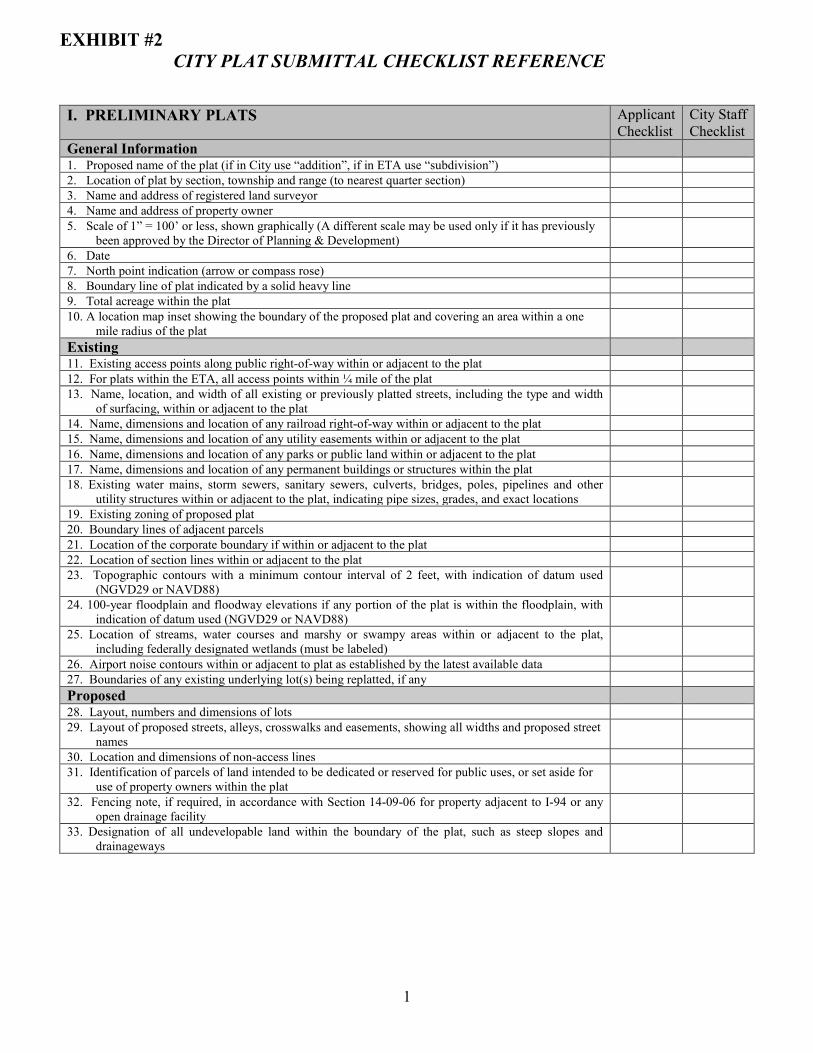
1
EXHIBIT #2 CITY PLAT SUBMITTAL CHECKLIST REFERENCE
I. PRELIMINARY PLATS Applicant Checklist
City Staff Checklist
General Information 1. Proposed name of the plat (if in City use “addition”, if in ETA use “subdivision”) 2. Location of plat by section, township and range (to nearest quarter section) 3. Name and address of registered land surveyor 4. Name and address of property owner 5. Scale of 1” = 100’ or less, shown graphically (A different scale may be used only if it has previously
been approved by the Director of Planning & Development)
6. Date 7. North point indication (arrow or compass rose) 8. Boundary line of plat indicated by a solid heavy line 9. Total acreage within the plat 10. A location map inset showing the boundary of the proposed plat and covering an area within a one
mile radius of the plat
Existing 11. Existing access points along public right-of-way within or adjacent to the plat 12. For plats within the ETA, all access points within ¼ mile of the plat 13. Name, location, and width of all existing or previously platted streets, including the type and width
of surfacing, within or adjacent to the plat
14. Name, dimensions and location of any railroad right-of-way within or adjacent to the plat 15. Name, dimensions and location of any utility easements within or adjacent to the plat 16. Name, dimensions and location of any parks or public land within or adjacent to the plat 17. Name, dimensions and location of any permanent buildings or structures within the plat 18. Existing water mains, storm sewers, sanitary sewers, culverts, bridges, poles, pipelines and other
utility structures within or adjacent to the plat, indicating pipe sizes, grades, and exact locations
19. Existing zoning of proposed plat 20. Boundary lines of adjacent parcels 21. Location of the corporate boundary if within or adjacent to the plat 22. Location of section lines within or adjacent to the plat 23. Topographic contours with a minimum contour interval of 2 feet, with indication of datum used
(NGVD29 or NAVD88)
24. 100-year floodplain and floodway elevations if any portion of the plat is within the floodplain, with indication of datum used (NGVD29 or NAVD88)
25. Location of streams, water courses and marshy or swampy areas within or adjacent to the plat, including federally designated wetlands (must be labeled)
26. Airport noise contours within or adjacent to plat as established by the latest available data 27. Boundaries of any existing underlying lot(s) being replatted, if any Proposed 28. Layout, numbers and dimensions of lots 29. Layout of proposed streets, alleys, crosswalks and easements, showing all widths and proposed street
names
30. Location and dimensions of non-access lines 31. Identification of parcels of land intended to be dedicated or reserved for public uses, or set aside for
use of property owners within the plat
32. Fencing note, if required, in accordance with Section 14-09-06 for property adjacent to I-94 or any open drainage facility
33. Designation of all undevelopable land within the boundary of the plat, such as steep slopes and drainageways

2
II. FINAL & MINOR PLATS Applicant Checklist
City Staff Checklist
1. Minimum sheet size of 30” x 36”. If more than one sheet is required, an index sheet showing the entire plat on one sheet must submitted, all sheets must be numbered, of the same size, and include matchlines. A border of ½ inch shall be proved on the top, bottom, and right sides of the plat and a border of 2 inches shall be provided on the left side
2. Name of the plat (if in City use “addition”, if in ETA use “subdivision”) 3. Location of plat by section, township and range (to nearest quarter section) 4. Name and address of registered land surveyor 5. Name and address of property owner 6. Scale of 1” = 100’ or less, shown graphically 7. Basis of bearings 8. Date 9. North point indication (arrow or compass rose) 10. Boundary line of plat based on an accurate traverse, with angular and linear dimensions 11. Legal description of property being platted 12. Accurate locations of all monuments. One monument shall be noted at each corner and at each
change of direction in the boundary line of the plat; one monument shall be noted at each block corner; one monument shall be noted at each point of deflection in the interior lot lines; and one monument shall be noted at the point of curvature and point of tangency of each curve in a street line on both sides of the street
13. True angles and distances to the nearest established street lines or official monuments, not less than 2 need to be accurately described on the plat. For plats adjacent to or within the current corporate limits, a tie to at least one official monument is required. For plats within the ETA, ties to two official monuments are required. For purposes of this requirement, an official monument is an official government monument, such as a section corner or quarter section corner
14. Ties to within 12 inches of a minimum of two accepted State Plane Coordinate monuments based on NAD 83 ND Zone 3302
15. Exact location, width and name of all streets within and adjoining the plat and exact location of all alleys and crosswalks within the plat
16. Accurate outlines and legal descriptions of any areas (not including streets, alleys or public utility easements) to be dedicated or reserved for public use, with the purposes indicated; and of any area to be reserved for common use of all property owners within the plat
17. All easements for rights-of-way provided for public services and utilities 18. All lot numbers and lot lines, with accurate dimensions in feet and hundredths 19. Square footage or acreage of land within the plat, each individual lot, each sublot created by ghost
platting, and the total area in streets
20. Location and dimensions of non-access lines 21. Fencing note, if required, in accordance with Section 14-09-06 for property adjacent to I-94 or any
open drainage facility
22. 100-year floodplain and floodway elevations and topographic contours with a minimum contour interval of 2 feet for any portion of the plat within a designated floodplain, with indication of datum used (NGVD29 or NAVD88)
23. All airport noise, clear zone and approach zone elevations within or adjacent to plat as established by the latest available data, with indication of datum used (NGVD29 or NAVD88)
24. Present shoreline locations and water elevations shown and dated for any waterways or bodies of water within the plat
25. For plats adjacent to the Rivers, the cfs flow elevation must be shown 26. Certification by a registered surveyor that the plat represents a survey made by him/her, the
monuments shown are accurate, and all dimensional and geodetic details are correct
27. Notarized certification by all owners of the land of adoption of the plat and dedication of sewers, water distribution lines, streets, public areas and other improvements
28. Proper form for approval of the Planning & Zoning Commission 29. Proper form for acceptance of the plat and amendment of the master plan by the Board of City
Commissioners
30. Proper form for approval by the City Engineer 31. For plats within the ETA, proper form for acceptance of the rights-of-way by the County Board of
Commissioners
32. A storm water management note shall be shown in accordance with Title 14.1 09/05