
MANUAL FOR DATA COLLECTION IN THE CENSUS OF MINOR...
37
MANUAL FOR DATA COLLECTION IN THE CENSUS OF MINOR IRRIGATION SCHEMES 2013-14 GOVERNMENT OF INDIA MINISTRY OF WATER RESOURCES
Transcript of MANUAL FOR DATA COLLECTION IN THE CENSUS OF MINOR...

MANUAL FOR
DATA COLLECTION IN
THE CENSUS OF MINOR IRRIGATION SCHEMES
2013-14
GOVERNMENT OF INDIA MINISTRY OF WATER RESOURCES

- 1 -
MINOR IRRIGATION (STATISTICS) DIVISION INTRODUCTION
The Centrally Sponsored Plan Scheme “Rationalisation of Minor Irrigation
Statistics (RMIS)” was launched in 1987 with 100% Central assistance to the States/UTs. The aim of RMIS scheme is to build a comprehensive and reliable database in the Minor Irrigation Sector for future planning. The major activity under the scheme is the All India Census of Minor Irrigation Schemes conducted quinquennially in the states covering all ground water and surface water Minor Irrigation schemes .
The first census of Minor Irrigation schemes with reference year 1986‐87
was conducted in the States/UTs and the report was published in November 1993. The second census with reference year 1993‐94 was initiated in September 1994 and the report was published in March 2001. The information in respect of adoption of newly developed technology of Water and Energy Conserving Devices such as Sprinkler and Drip Irrigation System and use of Non Conventional Energy sources such as Solar Pumps and Wind Mills was collected in this round. For the first time the census data was computerized with the help of National Informatics Centre and the results were put on Web Site of the Ministry. The 3rd census of M.I. Schemes with reference year 2000‐2001 was conducted in 33 States/UTs. The report was released in November 2005 and the 4th Census of MI Schemes has been conducted with the reference year 2006‐07. The data has been processed and shall be published soon. The data collected in the Census is utilized for formulation of the proposals for the Five Year Plans. The census data is also utilized for estimation of Ground Water Resources by the Central Ground Water Board. In addition to this, Central Water Commission and various Wings of Ministry of water Resources, etc. use the Census data extensively.
The 5th Census of Minor Irrigation Schemes will be conducted with reference year 2013‐14. The field work of the census will be taken up from the month of October, 2014. Present manual highlights important guidelines and definitions concerning irrigation schemes for use of field level officers.

- 2 -
PROGRAMME OF WORK FOR THE FIFTH MI CENSUS Census Commissioner, Nodal Officers and Field agencies: The MI Census will be conducted under the overall charge of MI Census Commissioner who will be a Senior Officer of the nodal department. of State/ UT. concerned The fieldwork will either be undertaken by the nodal department itself or entrusted/ outsourced to some other agencies which the State/UT Government consider fit in respect of infrastructure available with it. Ministry of Panchayati Raj in states can be one such option for collection of field data as they have officers in all the Panchayats. However, for the entire census operation Minor Irrigation Census Commissioner of the State/ UT shall be the pivotal point. The primary work of collection of data will be carried out by the enumerators. They may be village level workers or village accountants or Lekhpals or Patwaries or some private enumerators in case the field work is outsourced, as the case may be. The work of supervision will be entrusted to higher supervisor level officers of the field agency. However the overall quality of field work is to be monitored by Block/District level/ State officers, who in order to ensure the correctness of data will conduct frequent site visits of the schemes and check the entries made by primary enumerators. Field Work:
i. One schedule for the village is to be filled by the Patwari/ Lekhpal for the village.
ii. The scheme schedules are to be filled by the enumerators designated by the state. The primary enumerators should take along list of all schemes covered in the last census during 2006‐07 while going for field work. He should visit and cover all the schemes again. He should fill in schedules for all the schemes which were complete before the end of the reference Year.
iii. The primary enumerators while canvassing the schedules will visit the owner of the Minor Irrigation Schemes or its nearest neighbor and collect information on the basis of personal enquiry from him. The physical verification of the schemes will also be done by the enumerators. They would be required to put the scheme number in black paint on the structure of the scheme or on any fixed structure nearby for future verification. The purpose of the Census should be explained to the farmers to win over their confidence in revealing the specific information in respect of Minor Irrigation works. Assurance that the data furnished by them would be kept confidential needs to be given to the farmers. Certain information relating to the scheme will be collected by the enumerators by physical examination of the scheme.

- 3 -
Field data verification: i. The block level officer will visit at least 5 villages in his blocks and
physically verify the schemes covered, quality of census and the extent of coverage of schemes in the village and scrutinise at least 5 schemes in each village, in order to ensure the correctness of data collected. A Supervisor report is to be submitted through computer after the supervision is over.
ii. The District level officer shall visit 5 separate blocks in his district and select one village in each Block and verify 5 schemes in each village. A Supervisor report is to be submitted through computer after the supervision is over.
iii. The State level consultant, appointed by the Centre in the state shall visit the field alternate day and monitor the progress of work, check the quality of data and help the enumerators in their conceptual problems.
iv. The nodal officer/ Consultant shall go through all the inspection reports. If any corrective action is to be taken, it should be taken immediately and a consolidated report of the inspection may be sent to the centre in the by 10th of every month.
Development of Software:
The application for the development of software is to be developed by NIC, who shall provide all the necessary IT support including Training for data entry to the State Level, District Level, Block Level persons involved in data processing. Since the data entry and the other software for validation, tabulation, report generation will be prepared by NIC, They will give the necessary trainings for data processing at the All‐India level in workshop followed by such trainings at District/Block level through its state agencies. The CDs containing the software will be provided to the state nodal officers by the time the data collection work starts in the field.
Training to Field Staff: The training is to be provided at the regional level to the State Govt. officers in 5 such workshops zone‐wise, consisting of 6‐7 states/UTs providing training to 4‐6 senior from each state in the zone at one workshop by the senior officers from this Ministry. The regional workshops will be followed by state‐level training of trainers in each state/ group of states/UTs by the officers of concerned states trained in the regional training workshops. There will be a MoWR officer present as observer in each such state‐level training workshop. The state‐level trainings will be followed by district and block/Tehsil‐level trainings for the primary workers and the

- 4 -
supervisors at the lowest level. Power Point Presentations for trainings in Hindi and English will be provided to all states in CDs to do their translation in their state language for presentation. The training manual and the schedules for collecting the data will also be made available to state/ UTs in Hindi and English at the earliest, which may be got translated into their state language before getting them printed in the required number before the District‐level trainings.

- 5 -
SCHEDULES OF ENQUIRY In this census three types of schedules are prescribed, viz. ‐ (i) Village schedule, (ii) Ground Water scheme Schedule, and (iii) Surface Water Scheme Schedule.
i. As the name suggests, the village schedule contains items for collection of information about total agricultural, irrigated area and the number of Minor Irrigation schemes, water bodies in the village as a whole and shall be filled up by the village Patwari/ officer possessing the village revenue records on the basis of records.
ii. The Ground Water scheme schedules will contain items for collection of detailed data related to specific ground water schemes viz. dug well, shallow tube well, medium tube well and deep tube well. One such schedule will be filled for each such scheme existing in the village for irrigation purpose, either in use or not in use from 2007‐08 or later.
iii. The Surface Water Scheme schedules will contain items for collection of detailed data related to specific surface water scheme, i.e. Surface flow or surface lift irrigation scheme. One such schedule will be filled for each such scheme existing in the village for irrigation purpose, either in use or not in use from 2007‐08 or later. The Census data will be collected through canvassing enumeration schedules for each revenue village and all minor irrigation schemes either in use or not in use from 2007‐08 or later. In case of institution owned Minor Irrigation works, it will be necessary to verify the information from available records also.
_________

- 6 -
CONCEPTS AND DEFINITIONS: Cultivable Command Area (CCA): The area which can be irrigated from a scheme and is fit for cultivation. Cultivable area: It consists of net area sown, current fallow, fallow lands, other lands, current
fallow, culturable waste and land under miscellaneous tree crops. Gross Irrigated Area:
The area irrigated under various crops during a year, counting the area irrigated under more than one crop during the same year as many times as the number of crops grown and irrigated.
Net Irrigated area: It is the area irrigated through any source in a year for a particular crop.
Irrigation Potential Created (IPC): The total gross area proposed to be irrigated under different crops during a year by a scheme. The area proposed to be irrigated under more than one crop during the same year is counted as many times as the number of crops grown and irrigated. If original Irrigation Potential of the scheme is not known then the maximum area irrigated during the past five year or so may be taken as the IPC.
Irrigation Potential Utilised (IPU): The gross area actually irrigated during reference year out of the gross
proposed area to be irrigated by the scheme during the year. Minor Irrigation (M.I.) Scheme:
A scheme having CCA up to 2,000 hectares individually is classified as minor irrigation scheme.
Medium Irrigation Scheme: A scheme having CCA more than 2,000 hectares and up to 10,000 hectares individually is a medium irrigation scheme.
Major Irrigation Scheme: A scheme having CCA more than 10,000 hectares is major irrigation scheme.
Sprinkler Irrigation System: Sprinkler Irrigation is a method of applying irrigation water which is similar to rainfall. Water is distributed through a system of pipes usually by pumping. It is then sprayed into the air of entire soil surface through spray heads so that it breaks up into small water drops which fall to the ground.
Drip irrigation system: Drip irrigation system delivers water to the crop using a network of mainlines, sub‐mains and lateral lines with emission points spaced along their lengths. Each dripper/emitter, orifice supplies a measured, precisely controlled uniform application of water, nutrients, and other required growth substances directly into the root zone of the plant.
- 7 -
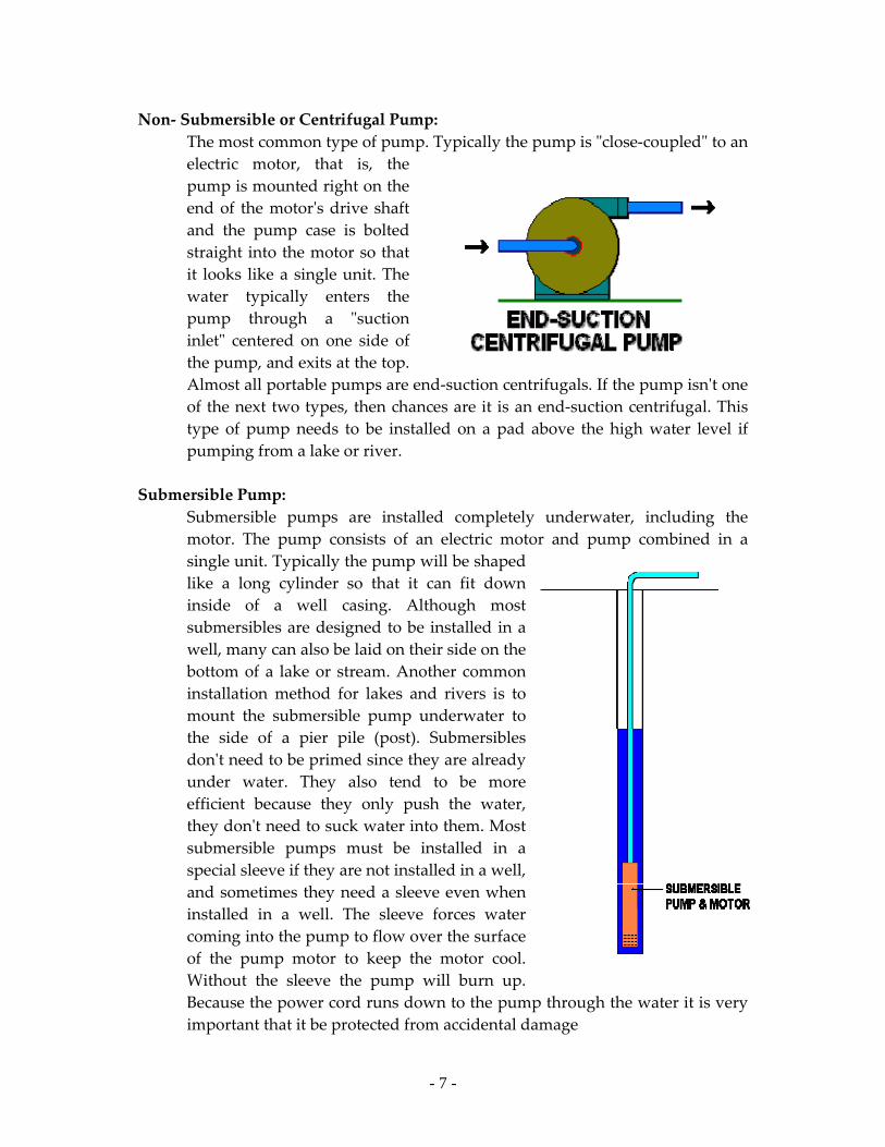
Non‐ Submersible or Centrifugal Pump: The most common type of pump. Typically the pump is ʺclose‐coupledʺ to an electric motor, that is, the pump is mounted right on the end of the motorʹs drive shaft and the pump case is bolted straight into the motor so that it looks like a single unit. The water typically enters the pump through a ʺsuction inletʺ centered on one side of the pump, and exits at the top. Almost all portable pumps are end‐suction centrifugals. If the pump isnʹt one of the next two types, then chances are it is an end‐suction centrifugal. This type of pump needs to be installed on a pad above the high water level if pumping from a lake or river.
Submersible Pump:
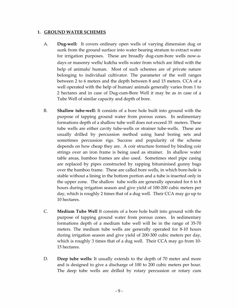
Submersible pumps are installed completely underwater, including the motor. The pump consists of an electric motor and pump combined in a single unit. Typically the pump will be shaped like a long cylinder so that it can fit down inside of a well casing. Although most submersibles are designed to be installed in a well, many can also be laid on their side on the bottom of a lake or stream. Another common installation method for lakes and rivers is to mount the submersible pump underwater to the side of a pier pile (post). Submersibles donʹt need to be primed since they are already under water. They also tend to be more efficient because they only push the water, they donʹt need to suck water into them. Most submersible pumps must be installed in a special sleeve if they are not installed in a well, and sometimes they need a sleeve even when installed in a well. The sleeve forces water coming into the pump to flow over the surface of the pump motor to keep the motor cool. Without the sleeve the pump will burn up. Because the power cord runs down to the pump through the water it is very important that it be protected from accidental damage

- 8 -
Turbines and Jet Pumps :
A turbine pump is basically a centrifugal pump mounted underwater and attached by a shaft to a motor mounted above the water. The shaft usually extends down the center of a large pipe. The water is pumped up this pipe and exits directly under the motor. Turbine pumps are very efficient and are used primarily for larger pump applications. They are typically the type of pumps used on municipal water system wells. When you see a huge motor mounted on its end over a well, that is most likely a turbine pump. I use turbine pumps for large parks and golf courses where we are pumping from lakes. The turbine pump is mounted in a large concrete vault with a pipe connecting it to the lake. The water flows by gravity into the vault where it enters the pump. The pump motors are suspended over the vault on a frame. A jet pump is similar to a turbine pump but it works by redirecting water back down to the intake to help lift the water.
Water body:
All natural or artificial units with some or no masonry work used for storing water for irrigation or other purposes are covered under water bodies. These are usually of various types known by different names like tank, reservoirs, ponds and bundhies etc. The distinction among various types of water bodies, however, is not very explicit.
Pond: A small body of water usually earthen though masonry dykes are also included and shallow made through excavations which represent a restricted environment. Ponds usually describe small bodies of water generally no one would require a boat to cross. Tanks: A shallow water unit usually larger than a pond created by constructing earthen or masonry barricades which receives water either from tube wells or rains. Reservoirs:
A large man made impoundment of varying magnitude created by erecting, bunds, dams barrages or other hydraulic structures across streams or rivers serving one or more purposes such as irrigation, power generation, flood control or other water resource development projects.
- 9 -
1. GROUND WATER SCHEMES
A. Dug‐well: It covers ordinary open wells of varying dimension dug or sunk from the ground surface into water bearing stratum to extract water for irrigation purposes. These are broadly dug‐cum‐bore wells now‐a‐days or masonry wells/ kutcha wells water from which are lifted with the help of animals/ human. Most of such schemes are of private nature belonging to individual cultivator. The parameter of the well ranges between 2 to 6 meters and the depth between 8 and 15 meters. CCA of a well operated with the help of human/ animals generally varies from 1 to 2 hectares and in case of Dug‐cum‐Bore Well it may be as in case of a Tube Well of similar capacity and depth of bore.
B. Shallow tube‐well: It consists of a bore hole built into ground with the
purpose of tapping ground water from porous zones. In sedimentary formations depth of a shallow tube well does not exceed 35 meters. These tube wells are either cavity tube‐wells or strainer tube‐wells. These are usually drilled by percussion method using hand boring sets and sometimes percussion rigs. Success and popularity of the scheme depends on how cheap they are. A coir structure formed by binding coir strings over an iron frame is being used as strainer. In shallow water table areas, bamboo frames are also used. Sometimes steel pipe casing are replaced by pipes constructed by rapping bituminised gunny bags over the bamboo frame. These are called bore wells, in which bore‐hole is stable without a lining in the bottom portion and a tube is inserted only in the upper zone. The shallow tube wells are generally operated for 6 to 8 hours during irrigation season and give yield of 100‐200 cubic meters per day, which is roughly 2 times that of a dug well. Their CCA may go up to 10 hectares.
C. Medium Tube Well It consists of a bore hole built into ground with the
purpose of tapping ground water from porous zones. In sedimentary formations depth of a medium tube well will be in the range of 35‐70 meters. The medium tube wells are generally operated for 8‐10 hours during irrigation season and give yield of 200‐300 cubic meters per day, which is roughly 3 times that of a dug well. Their CCA may go from 10‐15 hectares.
D. Deep tube wells: It usually extends to the depth of 70 meter and more
and is designed to give a discharge of 100 to 200 cubic meters per hour. The deep tube wells are drilled by rotary percussion or rotary cum
- 10 -
percussion rigs. These tube wells operate round the clock during the irrigation season, depending upon the availability of power. Their annual output is roughly 15 times that of an average shallow tube well and are usually constructed as public scheme which are owned and operated by government departments or corporations. Their CCA may go up to 50 hectares.
2. SURFACE WATER SCHEMES A. Surface flow irrigation scheme: These schemes use rainwater for irrigation purposes either by
storing it or by diverting it from a stream, nalah or river. Sometimes, permanent diversions are constructed for utilising the flowing water of a stream or river. Temporary diversions are also constructed in many areas which are usually washed away during the rainy season. The small storage tanks are called ponds or bundhis which are mostly community owned. The command areas of such schemes are 20 hectares or less. The large storage tanks whose command varies from 20 to 2000 hectares are generally constructed by government departments or local bodies. These are the biggest items of surface minor irrigation works.
(i) Storage schemes(Tanks and other storages) Storage schemes include tanks and reservoirs which
impound water of streams and rivers for irrigation purposes. After wells, tanks occupy a very important place under the minor irrigation programme. They provide nearly two‐third of the total irrigation from minor sources in the states of Andhra Pradesh, Karnataka, Kerala, Maharashtra, Orissa and Tamilnadu. Tracts with undulating topography and rocky sub‐strata are eminently suitable for tank irrigation. Besides, there exists scope for further construction of tanks in many areas. A large number of existing tanks in southern States have gone into disuse due to long neglect of repairs. Renovation of these tanks so as to restore the lost irrigation potential is being accorded priority under the minor irrigation programme.
The essential features of these schemes are
a. a bund or a dam which is generally of earth, but is also sometimes partly or fully masonry,
b. anicut and feeder channels to divert water from adjoining catchments,
c. a waste weir to dispose of surplus flood water,

- 11 -
d. sluice or sluices to let out water for irrigation, and e. conveyance and distribution system.
The size of the storage is determined by the run‐off expected on the basis of dependable monsoon rainfall in the catchment and by the fact whether the rainfall and cropping pattern would permit more than one filling of the tank.
(ii) Diversion schemes : These schemes aim at providing gravity flow irrigation
by mere diversion of stream water supply without creating any storage. As compared to storage schemes they are economical but their feasibility is dependent on the presence of flow in the stream at the time of actual irrigation requirements. Essentially such schemes consist of
a. an obstruction (weir) or bund constructed across the stream for raising and diverting water; the weir being called anicut in the South, bandhara in Maharashtra and Gujarat, and Bandh in the Assam region, and
b. an artificial channel, known as kul in the hilly areas, pyne in Chhota Nagpur and Bihar and dong in the Assam region.
In case of small schemes which have prominent scope in the hilly tracts and foot hill plains, the water is usually diverted by constructing temporary bunds across the streams, made up of earth, stones or even bamboos. The discharge handled being of small order, the bund on the head of the channel is not provided with any gated structure for controlling and regulating the flow. Construction of work, is, therefore, simple and cheap and can be handled to a large extent by the people themselves. However, these constructions being temporary, require frequent renovation. The bunds are liable to be washed away by every major flood. The channels also get silted up and scoured frequently. It is essential that whenever such schemes aim at diverting higher discharges, say more than 5 to 10 cusecs, or tackle streams having high intensity of flood discharge, proper regulation structures equipped with suitable types of gates are provided. Weir has to be provided with scouring sluices in order to regulate the flow of silt in the off‐
- 12 -
taking channels. The construction of masonry weir is comparatively simpler and cheaper where rocky foundation is available beneath the streambed. The design of the weir on permeable and erodible foundation is more complicated and requires specialised engineering knowledge. The irrigation capacity of the diversion schemes is dependent on the actual flow in the stream at the time the irrigation is required. The cold weather and the hot weather flow, therefore, need to be ascertained carefully before deciding the feasibility and economics of these schemes. This is particularly important in the case of non‐snow fed flashy streams that spurt to lift suddenly in the rainy season after which the discharge in them dwindles down to appreciable quantity. Some diversion schemes are also constructed as kharif or monsoon channels supplying water only during the monsoon season. Such schemes are useful for providing supplemental irrigation for paddy and preliminary watering for sowing of rabi.
In most of the hilly tracts, small irrigation channels called ‘kuls’ are the only means of irrigation. These channels carry water diverted from streams by constructing temporary or pucca bunds across the streams. These channels are often constructed in hazardous hilly terrain under very difficult conditions. To avoid seepage of water and for the sake of stability, these channels are lined in most of the reaches.
(iii) Water conservation‐cum‐ground‐water recharging Schemes: Under this head are included schemes which serve
primarily one or more of the following purposes: a. submerging agricultural land during monsoon for
sowing post‐monsoon crops, b. improving moisture regime of the adjoining fields
downstream for raising of post‐monsoon crops without irrigation and replenishing the ground water.
An additional advantage of these schemes is that they help to conserve the soil. When constructed in the head water region serving catchment area of tanks down below, they serve the

- 13 -
important purpose of retarding the silting rate of these tanks.
The system of water conservation through field embankments is peculiar to central Indian tracts and is commonly in vogue in the northern Madhya Pradesh, Bundhelkhand region of Uttar Pradesh and eastern Rajasthan. In the Bundhelkhand region, these works are popularly known as ‘bundhies’, which consist of earthen embankments thrown across gently sloping ground. During the rainy season, water is stored upstream and the land gets submerged. If the land slope is gradual, often large areas get submerged even by low embankments. Ordinarily, no direct irrigation is carried out and benefit is mostly due to submergence. In nearly all these areas, the soil is generally black which is retentive of moisture. After remaining submerged under water during the rainy season, the soil retains sufficient moisture to grow good rabi crops. The remaining water is let out and the submerged land released for cultivation. The other advantage of submerging land in this manner is that the first flood brings a lot of silt which acts as rich manure. By preventing free flow of water across steep gradient, the soil of the land is also conserved.
Ahars in Bihar, which store water for irrigation of paddy fields, also function somewhat in a similar manner. Water is let out in October for irrigating the rice fields and the drained out fields in the bed of the ahars are cultivated with rabi crops. The head water tanks popularly in vogue in Orissa have a similar role to perform. These consist of bunds put up across slope at the head of gullies with the objective of impounding and diverting the cumulative run‐off into the wider valley area downstream of the bunds by percolation, seepage and surface flow. Surface channels are provided in the flanks to carry floodwater received in excess of the storage capacity of the bunds during the monsoon season. Percolation tanks primarily constructed for the purpose of recharging ground water are in vogue in Maharashtra, Tamilnadu, Kerala and Rajasthan. Check‐dams or rapats are in vogue in Rajasthan. They consist of bunds constructed across the streams for the purpose of retarding the surface flow and also the sub‐surface flow to some extent by making the bed slope of the stream flattened. This results in increased

- 14 -
percolation of water in the sub‐soil with consequent increase of the ground water supply.
B. Surface Lift Irrigation Scheme: In regions where the topography does not permit direct flow
irrigation from rivers and streams, water has to be lifted into the irrigation channels. These works are similar to diversion schemes, but in addition pumps are installed and pump houses constructed. These schemes, being costly in operation, are feasible only in areas where
a. gravity flow irrigation is not possible b. there is keen demand for irrigation and cultivators are
enthusiastic, c. water is available in the streams for at least about 200 days in a
year, and d. cheap electric power is available.
Installation of diesel operated pump sets for lifting water makes the operation and maintenance cost of these schemes exorbitantly high. However, for lifting small order of discharge by individual cultivators, portable diesel engine pump sets are feasible as they provide greater flexibility and mobility for installation at different points of the water source or sources. In some areas Solar Pumps are also used for lifting water. The CCA of such schemes may go up to 20 hectares.

- 15 -
GENERAL INSTRUCTIONS FOR FILLING SCHEDULES
VILLAGE SCHEDULE
This is to be filled up for each village in the district. Some general information about the village is to be written. The items are self explanatory. I. IDENTIFICATION: The name of the State/District/Block(Tehsil)/Village will be written with Code as updated by states and sent to NIC after 2011 census. If after 2006‐07, any new district or block( Tehsil) or village has been created the same may be noted separately by the State concerned with a new code, to be given in consultation with NIC. Revenue villages will be taken into consideration. Either Block or Tehsil may be noted as per the preference in the state and if both are functioning in the state Block may be recorded.
Date of enumeration: it will be noted in the format DD/MM/YY
II. Special Information:
1. If the village is classified as tribal village depending upon the proportion of tribal population living in the village, as per definition in the state, it will be treated as tribal and code 1 will be given, otherwise code 2 will be given.
2. a) if any major or medium irrigation scheme is providing irrigation in the village area, then code 1 will be entered and otherwise code 2 will be given. b) in case answer is yes in item 2 (a), the name(s) of the major or medium schemes providing irrigation in the village area will be noted.
3. Total geographical area of the village including populated, agricultural and non-agricultural area will be noted as per village records in ha in whole number.
4. Total area of the village which is fit for cultivation in any season will be included in cultivable area in Ha in whole number. It should be less than or at most equal to the geographical area of the village as recorded in item no. 3. In case there is significant decrease in cultivable area reasons may be given in remarks.
5. Total area in the village which has been cultivated and any crop is sown in any one season of the year will be taken as net sown area in Ha

- 16 -
in full number and the same area will not be counted again if it is sown for more than one crop in different seasons. Any area will be counted only once. Net sown area should be less than cultivable area.
6. Gross area irrigated will be noted season-wise for different crop seasons. It will be noted in Ha with two decimal points. Any area which is sown and irrigated with a crop in a particular season will be counted for that season and similar procedure will be noted for all crops sown and irrigated in any area for the different seasons in the village. Gross area irrigated in any season should not be more than net area sown.
7. Net Irrigated Area will be noted as area cultivated and irrigated at least once in the reference year in any one season or for any one crop. It will be noted in Ha with two decimal points. Any area cultivated and irrigated for more than one crop will be recorded only once.
8. Ground water level in the village will be taken for the period before onset of monsoon and it may be noted for the reference year, 2013-14 in meters. Average ground water level in the village should be taken as observed prior to on-set of monsoon before the agricultural year 2013-14. In case there is very high increase or very significant decrease from the previous census, reasons may be noted in the remarks column.
9. No. of water bodies: in part (a) those water bodies by type will be counted which are used for irrigation purposes. Water bodies in existence for surface storage of water in the form of reservoir, tanks, ponds, and other storages will be noted against this item. Those water bodies which are used for irrigation and the same may or may not be used for other purposes, such bodies will be covered. Such water bodies will also be considered for filling surface water scheme schedule for each such scheme separately.
In item no. 9(b), those water bodies which were earlier used for irrigation purposes but have since become extinct will be counted, and their total number will be noted against 9 ( b) part (i). If there were any such water bodies, then out of those, which could be revived ,their number will be noted in 9 (b) part (ii).
In item no. 9 (c) those water bodies will be counted which are not used for irrigation purposes and may be meant for drinking/fishing and or for recharge of ground water only. Number of such water bodies will be noted in part (i) and area of such water bodies will be noted in part (ii). For estimation of area, approximate length and width may be taken into account and in case of rectangular design, length and width may be multiplied to obtain approximate area and in case of circular or elliptical structures, the product of length and

- 17 -
width may be reduced by 10-15 percent depending upon the difference between length and width.
10. If there is any association of cultivators for taking decisions on matters related to utilization of water either for major/medium irrigation projects or for public sector minor irrigation scheme(s) in the village will be considered in this item and answer will be given as 1 if yes, and 2 otherwise.
SUMMARY INFORMATION: This should be recorded after filling up detail schedule of each Minor Irrigation Scheme. The total number of schemes enumerated separately for ground water and surface water and their total will be recorded in the space provided in the schedule, for ensuring completeness at data processing centers. Name of Enumerator and designation should be written in CAPITAL letters clearly and signature should be with date. Name of Supervisory officer and designation should be written in CAPITAL letters clearly and signature should be with date.
***************

18
GENERAL INSTRUCTIONS FOR FILLING SCHEDULES
Schedule 1: Ground Water Scheme Schedule
All ground water schemes viz., Dug wells, Shallow Tube Wells and Deep Tube Wells in the village which are mainly for irrigation purpose and are complete, will be listed and enumerated. Ground water schemes which are used for irrigation purposes only will be included for filling ground water scheme schedule. In such schemes which are `not in use’ for irrigation purposes since 2006-07 or before will not be included in coverage. It may be ensured that no eligible scheme is missed. It may be noted that if the command area of a scheme spreads in more than one village, in that case also it will be treated as one scheme only in the village where it is located. Separate schedule will be filled for each ground water scheme. Schedules are to be filled up for schemes commissioned during or before 2013‐14 only. I ‐ IDENTIFICATION: The name of the State/District/Block(Tehsil)/Village will be written with Code as updated by states and sent to NIC after 2011 census. If after 2006‐07, any new district or block( Tehsil) or village has been created the same may be noted separately by the State concerned with a new code, to be given in consultation with NIC. Revenue villages will be taken into consideration. Either Block or Tehsil may be noted as per the preference in the state and if both are functioning in the state Block may be recorded. II ‐ SPECIFIC INFORMATION: Item No. 1: Serial No. of the Scheme: The schemes should be given nos. 1, 2 ‐‐‐ , as the schedules are filled. This no. will serve as an identification no. of that particular scheme. Item No. 2.: Type of Scheme The type of the scheme is to be recorded in terms of code Dug Well‐1, Shallow Tube well ‐2, Medium Tube well – 3, Deep Tube well‐ 4. In case of Tube wells, those with up to 35 meter depth of bore will be noted as shallow tube wells, while those tube wells with 35‐70 meters depth of bore will be classified as medium tube wells. Tube wells with more than 70 meters of depth of bore and designed to give a discharge of 100 to 200 cubic meters per hour will be noted as deep tube wells. These tube wells operate round the clock during the irrigation season, depending upon the availability of power.

19
Item No. 3: Owner of the Scheme: Name should be recorded in case of individual farmer being owner of the scheme and appropriate code should be given.
Govt. Owned ‐ 1 , Cooperative owned – 2, Panchayat Owned ‐ 3 Owned by Group of Farmers – 4, Owned by individual farmer ‐ 5 Others – 9.
The owner of the scheme may be farmer /cooperative society/government department / organization / group of farmers. The type of ownership is to be indicated in this item with code. In case of absentee, it may be enquired from the neighbour or from the person who is in possession of the scheme. In case the scheme is owned by individual farmer, the name of the owner may be written. Item No.4 (a): Khasra No./Plot No./ Survey No. / J.L.No./ Mouza No. in which the scheme is located Khasra no./Plot no./Survey no./ in which the scheme is installed shall be noted against this item for physical verification etc. which may be needed at a later date. Item No.4 (b) Location particulars of the schemes will be given based on permanent land marks, so that it can be uniquely identified. While each MI scheme will be given a number village wise it will be marked by paint on the body of the scheme which is easily visible. However, location particulars with the help of permanent landmarks giving existence of some unique feature on any side of the scheme, plot where it is located should be mentioned e.g. any tree by name, building, temple/ any small created structure or existence of any hill/drain/canal/road in any direction of the scheme. Item No. 5(a) : Total Ownership holding of the Owner (0.000 Ha.) This item should be filled up in case of individual owner only; the total area owned by the owner is to be mentioned in hectares. The land owned by owner of the scheme in his/her name will be mentioned in ha with 3 decimal points against this item. At the time of filling of this schedule if the ownership is available in local units it may be noted by pencil as such and later at the time of finalizing the schedule, local units may be converted into ha with the help of calculator and then it should be filled. Item No.5 (b): Social Status of owner (in case of individual owner only): Appropriate code for social status, scheduled caste, scheduled tribe, OBC or others as the case may be, will be given in case of individual owner only.
Schedule Caste – 1, Schedule Tribe ‐ 2, OBC ‐ 3, Others ‐ 9 The social status as per the central govt. notification may only be used. In some states some castes have been recognized as special backward classes only within the state for state govt.
20
jobs but not for central govt. purpose, such clarifications should not be considered. If a caste is included in SC/ST or OBC for All India selection then only it should be considered for particular clarification. Item No.6 : Year of Commissioning of the scheme Appropriate code for the year of commissioning of the scheme should be mentioned. The schemes which were installed during 2006‐07 or before are to be indicated with code number ‘1’.
On or before 2006‐07 – 1, During 2007‐08 – 2 During 2008‐09 – 3, During 2009‐10 – 4 During 2010‐11 – 5, During 2011‐12 – 6 During 2012‐13 – 7 During 2013‐14 – 8
The schemes to be covered in 5th census may be properly understood. In ground water schemes such dug wells commissioned during 2006-07 or before and are permanently `not in use’ should not be included. As such for item no. 6 if code is 1 then scheme should be either in use or temporarily `not in use’. Item No. 7. The nature of scheme It will be noted in case of Dug‐wells only. It is to be given only in case of dug wells. In case there is a dug well in which bore well has been installed it should be classified as dug-cum-bore well and if a well is not dug-cum-bore well then only it should be classified either as Pucca or Kutcha well depending on its walls being masonry or or of Kucha material. No dug-cum-bore well should be classified as Pucca or Kutcha well. Item No. 8. Details of the Scheme: The depth of well/tube-well/ dug-cum-bore well, diameter, depth of bore, distance from the nearest well/ tube well will be noted in meters ( except for diameter of tube well which wilted in mm ). Item No 9(a):Cost of construction of Scheme including machinery, if any (in Rs.): For schemes constructed prior to or during 2006‐07 their cost of construction excluding the cost of machinery, if any, at the time of installation will be reported. For the schemes constructed during 2007‐08 or afterwards, the cost incurred in the construction of the scheme excluding the cost of machinery, if any, at the time of installation, is to be reported. Cost of construction of the scheme should include cost incurred in construction of well/tube well including cost of drilling, cost of masonry work for lining the channels or construction of water distribution joint, small hut or room covering the well/tube well. In case of tube well, the cost incurred for installing one or more poles for bringing electric cable up to the tube well site should be included.
21
Item No 9(b):Cost of Machinery: The cost of machinery for motor/water drawing devices/pipes, drip or sprinkler system may be included in cost of machinery to noted in this item in Rs. It may include cost incurred on purchasing such equipments water distribution equipments over the years. Item No 9(c): Annual cost of maintenance during the year 2013‐14 : It may be noted in Rupees taking into account the repair and maintenance expenses borne on the schemes during the reference. The nature of replacements and additions to machinery may not be included here but in the cost of machinery. Item No 10(a) : Major Sources of finance (This item should be filled up in case of individual owner only ) : It is intended to find out two main major sources of financing of the scheme which could be through farmers’ own savings, bank loan or Governments subsidies. Appropriate codes will be recorded in this item. In case the scheme is financed by two or more sources, the source from which larger amount has been taken is to be recorded in first place and the second important source in the second space .
Bank Loan ‐ 1, Government fund ‐ 2, Own savings ‐ 3 Money lender – 4, Others – 9
In this item, the source of money for constructing the scheme or purchasing machinery may be considered. In case money is neither taken from govt. or from bank/ money lenders then either it may be from own savings or from friends and relatives. In case there is interest on loan from friends/relatives, it should be classified as from money lenders. Loan from co-operative societies may be taken as govt. loan and from co-operative banks or Gramin banks/ land development banks, it should be included in bank loan. Item No 10(b): Whether any subsidy/assistance provided by Govt. / PSU: In this item amount of subsidy received for construction of the MI scheme or for purchase of machinery for installation of scheme or for machinery including water distribution system will be noted in full Rupees separately in (i) for cost of construction, in (ii) for cost of machinery etc. If any subsidy or financial assistance is provided for construction of well/tube well or for machinery it may be noted in this item. In case MNAREGA assistance is provided for construction of well/tube well or for water channel or under-ground installation of the same may be valued and included against this item for the concerned part. Item No. 11 (a) : Current Status of the Scheme The information whether the
22
scheme is “in use” at present or “not in use” Temporarily or Permanently will be recorded in codes .
In use ‐ 1 Temporarily “Not in use” ‐ 2 Permanently “Not in use” ‐ 3
The wells which are not ‘in use’ during last two years due to temporary reasons but has also not been abandoned for use are categorized as temporarily `not in use’. Otherwise the scheme is treated as permanently ‘not in use’. Item No. 11 (b) Period since `not in use’: The period in number of years since ‘not in use’ will be noted against this item. It will be noted for both `temporarily not in use’ or `permanently not in use’. In case of schemes permanently not in use, such schemes cannot be out of use from or before 2006‐07, since those schemes would be out of coverage of Vth census. Item No. 12: Reasons code for Temporarily“not in use” Scheme (code‐2 in item 11 (a) ) Reason should be given in code for the schemes which are Temporarily “not in use”. Codes are as under:
Non availability of adequate power ‐ 1, Mechanical breakdown –2, Less discharge in the well/Tube well ‐ 3, Non‐availability of finance‐4, Lack of maintenance‐5, Any other reason – 9
Item No. 13: Reasons code for Permanently “not in use” Scheme (code‐3 in item 11(a)) Reason should be given in code for the schemes which are Permanently “not in use”. Codes are given below: Due to salinity – 1, Dried up – 2, Destroyed beyond repair ‐ 3
Due to sea water intrusion– 4, Due to industrial effluents‐5, Availability of Major/ Medium Project‐6 Due to other reasons ‐ 9
Item No 14: Water distribution/application method used Farmers are adopting different type of water distribution devices for irrigation. Recently, sprinkler and drip irrigation methods have gained popularity among the farmers besides conventional methods of ground water channel. Appropriate code is to be indicated for the water distribution devices being used by the farmers.
Open Water Channel (lined/pucca) ‐ 1 Open Water Channel (unlined/Kuchcha) ‐ 2 Under Ground channel ‐ 3
23
Surface Pipe ‐4 Drip ‐ 5 Sprinkler ‐ 6 Others ‐ 9
Item No 15(a) : No. of Lifting Devices The no. of devices used for lifting water from the source is to be indicated here. Item No 15(b) : Types of Lifting Devices The type of devices used for lifting water from the source is to be indicated here by appropriate code for up to two types available: Submersible Pump ‐ 1, Centrifugal Pump ‐ 2, Turbine – 3, Manual/animal – 4, Others – 9. It should be kept in mind that in case of a dug‐well, if any lifting device in the form of any pump operated with the help of electricity/ diesel/solar power is used, it should be classified as dug‐cum‐bore well only. Item No 16 : Source of Energy The source of energy for up to two types used for operating lifting devices for lifting water from the source is to be indicated by appropriate code:
Electric ‐ 1, Diesel – 2, Wind Mill – 3, Solar – 4, Manual/animal – 5, Others – 9.
Item No 17: Horse Power of Lifting devices (ignore, if lifting device is manual/animal driven)
Enter the Horse Power of the lifting devices used. If the no. of lifting devices is more than one, the combined horse power (HP) of all devices used for lifting water from the source will be recorded in this item. In case of manual/animal driven, this item will be crossed (X).
Item No. 18. Number of Operating Days: These are to be given for each season separately as per actual number of days of operation as informed by the farmer. In case of more than one device, total number of days of operation of all devices will be entered.
24
Item No. 19. Average Hours of pumping per day: These are to be given for each season separately as per actual average number of hours operated as informed by the farmer. In case of more than one device, total number of hours of operation of all devices will be entered here. Item No.20: Cultivable Command Area (CCA) (in Ha.) In this column the area proposed to be irrigated by the scheme during reference period should be indicated in hectare. It is generally the measurement of the field proposed to be irrigated by the scheme at the time of installation. In case the scheme is very old and the old cultivable command area is not feasible, due tio change in land use etc., the current maximum cultivable command area of the scheme will be noted. If the CCA is spread over to another village also, the whole CCA for the scheme may be entered for the scheme in the village where the schemes is located. Item No. 21 Whether the scheme is located in the command of Major and
Medium Schemes like Canal etc. Some of the minor irrigation schemes are located in the command of major and medium schemes for conjunctive use. Such schemes are also to be enumerated. The appropriate code depending upon their use may be noted in this item as :
No ‐ 1 (Keep item 34 to item 38 blank) Yes ‐ 2 (Keep item 27 to item 31 blank) Yes – (for augmentation only ) – 3 (keep item 22 to item 38 blank). The scheme is meant for recharge of ground water only.
Item No 22 to Item No 26 : Season wise Cultivable Irrigation Potential Created (IPC) : It is intended to find out the gross potential created from the scheme. It will indicate the area under Kharif, Rabi, perennial and other crops proposed to be irrigated. The total of item 22 to 25 is to be noted in item 26. The figures under item 22 , 23, 24 & 25 should be season wise area proposed to be irrigated by the scheme. If the scheme has been improved upon by major addition in machinery or water distribution devices added, then revised potential is to be indicated. Item 26 will indicate the gross irrigation potential created. Irrigation potential will be recorded with two places of decimals.
25
Item No 27 to Item No 31: Season wise actual area irrigated (IPU) during 2013‐14: In these columns, the area actually irrigated under kharif, rabi, perennial and for other crops during the year 2013‐14 shall be reported. Item 31 will indicate the gross irrigation potential utilised. Figure in item 31 would normally be less than or equal to the figure in item 26. Item No. 32. The Status of Working of Scheme :
The working condition of the scheme will be noted here as 1 for Yes and 2 for No. Item No. 33. If Not functioning well Maximum Potential Utilised in any Year: If code is 2 in Item 32, the maximum potential utilised during the years since commissioning of the scheme will be noted in Ha.
Item No 34 to Item No 38: Season wise area irrigated by the Minor irrigation
schemes (during 2013‐14) as supplementary source in the command of major and medium schemes:
These items will be filled only for those minor irrigation schemes
which are located in the actual command area of major and medium irrigation projects and serve the purpose of supplementary irrigation. For example a Dug well/ Tube well in the command area of Major or Medium Scheme. It will be decided on the basis of actual availability of water from the Major/ Medium Irrigation project in to the fields under the coverage of the MI scheme concerned. In order to assess the extent of such supplementary irrigation, data are to be recorded under item 34 to 38. If there is non‐zero entry in item 38, then reasons for using M I Scheme in command area may be given remarks at the end of schedule.
For recording the potential utilized through the scheme in such cases
gross irrigated area will be divided in proportion to number of watering to the field. For example, if the field is irrigated two times by M.I. scheme and three times by major / medium scheme, then irrigation potential utilized by M.I. scheme will be 2/5 times of the field area.
Item No 39: Whether under utilization of irrigation scheme. It has to be ascertained for under‐utilisation, and if it is Yes, 1 code is to be given in part (i) and 2 for No. Scheme shall be considered under‐utilised if the IPU is significantly less than IPC. If there is code 1 in part (i) the reason for the under‐utilisation of scheme is to be mentioned in terms of codes.

26
Non availability of adequate power ‐ 1 Mechanical break‐down ‐ 2 Less discharge in the well/ Tube Well ‐ 3 Non availability of Finance ‐ 4 Lack of Maintenance ‐ 5 Any other reason ‐ 9
27
GENERAL INSTRUCTIONS FOR FILLING SCHEDULES
Schedule 2 : Surface Water Scheme Schedule
All surface water schemes namely surface flow and surface lift schemes in the village which are mainly for irrigation purpose and are complete, will be listed and enumerated. All schemes in the village are to be listed and enumerated. It may be ensured that no one is missed. It may be noted that if the command area of a scheme spreads in more than one village, in that case also it will be treated as one scheme only in the village where it is located. Surface water schemes which are used for irrigation purposes only will be included for filling surface water scheme schedule. In such schemes which are `not in use’ for irrigation purposes since 2006-07 or before will not be included in coverage. Care may be taken not to miss any scheme. Separate schedule will be filled for each surface water schemes scheme. Schedules are to be filled up for schemes commissioned during or before 2013‐14 only. I ‐ IDENTIFICATION: The name of the State/District/Block(Tehsil)/Village will be written with Code as updated by states and sent to NIC after 2011 census. If after 2006‐07, any new district or block( Tehsil) or village has been created the same may be noted separately by the State concerned with a new code, to be given in consultation with NIC. Revenue villages will be taken into consideration. Either Block or Tehsil may be noted as per the preference in the state and if both are functioning in the state Block may be recorded. II ‐ SPECIFIC INFORMATION: Item No. 1: Serial No. of the Scheme: The schemes should be given nos. 1, 2 ‐‐‐ , as the schedules are filled. This no. will serve as an identification no. of that particular scheme. Item No. 2.: Type of Scheme The type of the scheme is to be recorded in terms of code Surface Flow Scheme ‐1, Surface Lift Scheme ‐ 2 . Such schemes like ponds or tanks/reservoirs with capacity for irrigation less than 2000 ha with water distribution by way of flow through channels up to the fields will be included in surface flow scheme (code 1). Those schemes in which water is being lifted from drain/rivers or pond/tanks with the help of pump sets by diesel/electric power or by

28
manual/animal driven method will be included in surface lift scheme. Those schemes where surface flow is used for taking water from source near to the field but to take the water at some distance from the channel if a lifting device is used to take water up to the field it will not be taken as a separate scheme but it will counted as a lifting device for the surface flow scheme. Any pond or tank which is not used for irrigation purposes and it is only for fishing/drinking or for recharge of ground water only, such water bodies will not be considered for filling surface water scheme schedule. Such ponds/tanks/reservoirs may be within the residential area of the village or near the fringes of the village and sometimes away from the village as well. As such due care may be taken with regard to such water bodies to know the use of such bodies with the help of knowledgeable persons of the village. Item No. 3: Owner of the Scheme: Name should be recorded in case of individual farmer being the owner and appropriate code should be given.
Govt. Owned ‐ 1 , Cooperative owned – 2, Panchayat Owned ‐ 3 Owned by Group of Farmers – 4, Owned by individual farmer ‐ 5 Others – 9.
The owner of the scheme may be single farmer /cooperative society/government department / organization / group of farmers. The type of ownership is to be indicated in this item with code. In case of absentee, it may be enquired from the neighbour or from the person who is in possession of the scheme. In case the scheme is owned by individual farmer, the name of the owner may be written. Item No.4: Khasra No./Plot No./ Survey No. / J.L.No./ Mouza No. in which the scheme is located Khasra no./Plot no./Survey no./ in which the scheme is installed shall be noted against this item for physical verification etc. which may be needed at a later date. Item No. 5(a) : Total holding of the Owner (0.000 Ha.) This item should be filled up in case of individual owner only; the total area owned by the owner is to be mentioned in hectares with three decimal places.
Item No.5 (b): Social Status of owner (in case of individual owner only): Appropriate code for social status of owner of the scheme, i.e. scheduled caste, scheduled tribe, OBC or others as the case may be, will be given in case of individual owner only.
Schedule Caste – 1, Schedule Tribe ‐ 2, OBC ‐ 3, Others ‐ 9

29
Item No.6 : Year of Commissioning of the scheme Appropriate code for the year of commissioning of the scheme should be mentioned. The schemes which were installed during 2006‐07 or before are to be indicated with code number ‘1’.
On or before 2006‐07 – 1, During 2007‐08 – 2 During 2008‐09 – 3, During 2009‐10 – 4 During 2010‐11 – 5, During 2011‐12 – 6 During 2012‐13 – 7, During 2013‐14 – 8
Item No. 7. The nature of scheme It will be noted as per codes provided as below: For Surface Flow Scheme : Reservoirs ‐ 1, Tanks/ponds ‐2, Other Storages ‐3, Permanent diversion ‐ 4, Temporary diversion ‐ 5 , Water conservation‐cum‐ground water recharge schemes /percolation tanks/check dams etc – 6, Spring Channel ‐ 7, Others – 9; In case of Surface lift Scheme : On River ‐ 1, On Stream ‐ 2, On drain/canal ‐ 3 , On Tanks/Ponds/Reservoirs/check dams ‐ 4, Others ‐9 Code 1 will be given in case of reservoirs which are larger in size and specially constructed for irrigation purposes. Code 2 may be given for ponds/tanks. A tank is neither very small and nor very large but it may require a ferry or boat to cross it while ponds are small water bodies mostly kutcha in nature and do not require a ferry or boat for crossing from one side to the other. Permanent diversions are those which are channels created to divert water from some surface water bodies for permanently diverting water for irrigation purposes. Temporary diversions are such diversions which are made for some time by kutcha construction for diverting water from some surface water bodies for irrigation purposes for short duration. Item No 8(a) : Cost of construction of Scheme, if any (in Rs.): For schemes constructed prior to or during 2006‐07 their cost of construction excluding the cost of machinery, if any, at the time of installation will be reported. For the schemes constructed during 2007‐08 or afterwards, the cost incurred in the construction of the scheme, if any, in Rs. at the time of installation, is to be reported. Cost of the construction in case of surface water schemes may include cost of labour for digging the pond/tank/other storage or diversion with or without masonry work and it may include cost of land in case land is actually purchased by the owner for

30
constructing water body. Value of the machinery will include water lifting device, distribution pipe, drip or sprinkler systems in case connected and the other machinery/equipment. Maintenance cost will include cost of de-silting of pond/tank, repair of the boundaries/channels or lifting devices, pipes etc. Item No 8(b) : Cost of Machinery for Scheme, if any (in Rs.): The cost of machinery purchased including the cost of water distribution system may be noted in this item in Rs. It may include cost incurred on purchasing such equipments for water distribution equipments over the years. Item No 8(c): Annual cost of maintenance during the year 2013‐14: It may be noted in Rupees taking into account the repair and maintenance expenses borne on the schemes during the reference. The nature of replacements and additions to machinery may not be included here but in the cost of machinery against 8(b). Item No 9 (a): Major Sources of finance up to Top most two It is intended to find out major sources of financing of the scheme which could be through farmers’ own savings, bank loan or Governments subsidies. Appropriate codes will be recorded in this item for two most important sources. In case the scheme is financed by more sources, the two sources from which largest amount has been taken are to be recorded as per priority.
Bank Loan ‐ 1, Government fund ‐ 2, Own savings ‐ 3 Money lender – 4, Others – 9.
In case money is neither taken from govt. or from bank/ money lenders then either it may be from own savings or from friends and relatives. In case there is interest on loan from friends/relatives, it should be classified as from money lenders. Loan from co-operative societies may be taken as govt. loan and from co-operative banks or Gramin banks/ land development banks, it should be included in bank loan. Item No 9(b): Subsidy provided by Govt./ PSU: If any subsidy/ grant was provided for construction of the scheme/ digging or for purchase of machinery/ distribution device will be noted here in full Rs. Separately. In case for digging of the pond or de-silting/renovation of water body, if assistance under MNAREGA is obtained through labour, value of the labour provided will be estimated and included in item no.9 (b).

31
Item No. 10 (a) : Current Status of the Scheme The information whether the scheme is “in use” at present or “not in use” Temporarily or Permanently will be recorded in codes .
In use ‐ 1 Temporarily “Not in use” ‐ 2 Permanently “Not in use” ‐ 3
The schemes which are not ‘in use’ during the last two years due to temporary reasons but has also not been abandoned for use are categorized as temporarily `not in use’. Otherwise the scheme is treated as permanently ‘not in use’. Item No. 10(b) Period since `not in use’: The period in years since ‘not in use’ will be noted against this item. It will be noted for both `temporarily not in use’ or `permanently not in use’. In case of schemes permanently not in use, such schemes cannot be out of use from or before 2006‐07, since those schemes would be out of coverage of Vth census. Item No.11: Reasons code for Temporarily “not in use” Scheme (code‐2 in item 10 (a) ) Reason should be given in code for the schemes which are Temporarily “not in use”. Codes are as under: Non availability of adequate power ‐ 1, Mechanical breakdown ‐ 2, Less discharge of the water ‐ 3, Storage not filled up fully ‐ 4, Siltation of Canal/Storage ‐ 5 , Breakdown of channels ‐ 6, Any other reason ‐ 9
Item No. 12: Reasons code for Permanently “not in use” Scheme (code‐3 in item 10(a)) Reason should be given in code for the schemes which are Permanently “not in use”, i.e. not in use for three or more years. Codes are given below: Due to salinity – 1, Dried up – 2, Destroyed beyond repair – 3, Destroyed
beyond repair ‐ 3, Due to sinking ‐ 4, Due to other reason ‐ 9 Item No 13: Water distribution/application method used Farmers are adopting different type of water distribution devices for irrigation. Recently, sprinkler and drip irrigation methods have gained popularity among the farmers besides conventional methods of ground water channel. Appropriate code is to be indicated for the water distribution devices being used
32
by the farmers. Open Water Channel (lined/pucca) ‐ 1 Open Water Channel (unlined/Kucha) ‐ 2 Under Ground channel ‐ 3 Surface Pipe ‐4 Drip ‐ 5 Sprinkler ‐ 6 Others ‐ 9
Item No 14(a) : No. of Lifting Devices The no. of devices used for lifting water from the source is to be indicated here. Item No 14(b) : Types of Lifting Devices The types of devices used for lifting water from the source is to be indicated here by appropriate codes for up to two types available: Submersible Pump‐ 1, Centrifugal Pump ‐ 2, Turbine – 3, Manual/animal – 4, Others – 9. Item No 15 : Source of Energy The source of energy used for operating lifting device for lifting water is to be indicated by appropriate code
Electric ‐ 1, Diesel – 2, Wind Mill – 3, Solar – 4, Manual/animal – 5, Others ‐ 9.
Item No 16: Horse Power of Lifting device (ignore, if lifting device is manual/animal driven)
Enter the power of lifting device. And if the no. of lifting devices is
more than one, the combined horse power (HP) of all devices used for lifting water will be recorded in this item. In case of manual/animal driven, this item will be crossed (X).
Item No. 17. Number of Operating Days: These are to be given for each season separately as per actual number of days of operation as informed by the farmer. In case of more than one device, total number of days of operation of all devices will be entered.

33
Item No. 18. Average Hours of pumping per day: These are to be given for each season separately as per actual average number of hours operated as informed by the farmer. In case of more than one device, total number of hours of operation of all devices will be entered here. Item No.19: Cultivable Command Area (CCA) (in Ha.) In this column the area proposed to be irrigated by the scheme during reference period should be indicated in hectare. It is generally the measurement of the field proposed to be irrigated by the scheme at the time of installation. In case the scheme is very old and the cultivable command area is not available, the current maximum cultivable command area of the scheme will be noted. If the scheme is spread over to another village also, the whole CCA for the scheme may be entered here. Item No. 20 Whether the scheme is located in the command of Major and
Medium Schemes like Canal etc. Some of the minor irrigation schemes are located in the command of major and medium schemes for conjunctive use. Such schemes are also to be enumerated. The appropriate code depending upon their use may be noted in this item
No ‐ 1 (Keep item 33 to item 37 blank) Yes ‐ 2 (Keep item 26 to item 30 blank) Yes – (for augmentation only ) – 3 (keep item 21 to item 37 blank)
Item No 21 to Item No 25 : Season wise Cultivable Irrigation Potential Created (IPC) : It is intended to find out the gross potential created from the scheme. It will indicate the area under Kharif, Rabi, perennial and other crops proposed to be irrigated. The total of item 21 to 24 is to be noted in item 25. The figures under item 21, 22, 23 & 24 should be season wise area proposed to be irrigated by the scheme. If the scheme has been improved upon then revised potential is to be indicated. Item 25 will indicate the gross irrigation potential created. Irrigation potential will be recorded in two places of decimals.

34
Item No 26 to Item No 30: Season wise actual area irrigated (IPU) during 2013‐14: In these columns, the area actually irrigated under kharif, rabi, perennial and other crops during the year 2013‐14 shall be reported. Item 30 will indicate the gross irrigation potential utilised. Figure in item 30 would normally be less than or equal to the figure in item 25. Item No. 31. The Status of Working of Scheme : The working condition of the scheme will be noted here in code as
Yes =1/No=2. Item No. 32. If Not functioning well Maximum Potential Utilised in any Year:
If code in item 31 is 2, the maximum potential utilised during the last 5 years since commissioning of the scheme will be noted in Ha.
Item No 33 to Item No 37: Season wise area irrigated by the Minor irrigation
schemes (during 2013‐14) as supplementary source in the command of major and medium schemes:
These items will be filled only for those minor irrigation schemes
which are located in the command of major and medium irrigation projects and serve the purpose of supplementary irrigation. For example a lift scheme on Tank/ Pond/ Drain is in the command area of Major or Medium Scheme. In order to assess the extent of such supplementary irrigation, data are to be recorded under item 33 to 37. If there is non‐zero entry in item 37, then reasons for using M I Scheme in command area may be given remarks at the end of schedule.
For recording the potential utilized through the scheme in such cases
gross irrigated area will be divided in proportion to number of watering to the field. For example, if the field is irrigated two times by M.I. scheme and three times by major / medium scheme, then irrigation potential utilized by M.I. scheme will be 2/5 times of the field area.
Item No 38: Whether under utilization of irrigation works. It has to be ascertained for under‐utilisation, and if it is Yes, 1 code is to be given in part (i) and 2 for No. Scheme shall be considered under‐utilised if the IPU is significantly less than IPC.

35
If there is code 1 in part (i) the reason for the under‐utilisation of scheme is to be mentioned in terms of codes. As below: Non availability of adequate power ‐ 1
Mechanical break‐down ‐ 2 Less discharge of water ‐ 3 Storage not fully filled up ‐4 Siltation of Canal/ Storage ‐5 Break down of Channels ‐6 Any other reason ‐ 9
Item No. 39. Specific Features of Reservoirs, Tanks etc.: It is intended to collect some information regarding the surface water scheme used for storing water.
(a) Designed Storage (in cubic metres): Designed storage of all the tanks / ponds / reservoirs in the village may be obtained with the help of surface area and the average depth of tank or from the records if available and their sum total may be written here.
(b) Filled up Storage (during 2013‐14)
Full ‐1, upto 3/4 ‐ 2, upto ½‐3, upto 1/4 ‐ 4 , Nil/Negligible filled up – 5. The Code will be entered depending upon the extent of filling up of storage during reference period.
(c) Status of filling up of storage The appropriate code will be decided based on the information
based on 50% filling up of storages in last 5 years Filled up every year ‐ 1 , Usually filled up ‐ 2 , Rarely filled up ‐ 3 , Never filled up ‐ 4
(d) The number of villages covered by the scheme will be noted against this item. The designed capacity of the reservoir may be available in records as these are generally owned by public sector, i.e. owned by cooperatives/ govt department and information may be taken from the records. In case of ponds/tanks owned by individual farmers, its approximate volume in terms of cubic meters may be estimated after conversion from local units as obtained from the owners.

36
With regard to part (d) it may be noted as per the information provided by the knowledgeable persons in case of water used for irrigation in more than one village. Even if a scheme is used for more than one village its particulars will be included in the schedule under the village where scheme is located and its entire irrigation potential created or irrigation potential used will be covered in one schedule in the village where that scheme is located. Item No. 40. Whether scheme has benefitted the Ground Water Level: It will be noted in terms of codes as 1 for yes, 2 for no and 3 for Can’t say. It may noted that in case code is one then code in 39 ( C ) may be either 1 or 2.


