Manual for Aerial Photo Interpretation in the National ...
81
MANUAL FOR AERIAL PHOTO INTERPRETATION IN THE NATIONAL INVENTORY OF LANDSCAPES IN SWEDEN NILS YEAR 2003 2003-11-17 SLU Department of Forest Resource Management and Geomatics 901 83 Umeå, Sweden Authors: Anna Allard, Björn Nilsson, Karin Pramborg, Göran Ståhl and Sture Sundquist
Transcript of Manual for Aerial Photo Interpretation in the National ...

MANUAL FOR AERIAL PHOTO INTERPRETATION
IN THE NATIONAL INVENTORY OF LANDSCAPES
IN SWEDEN
NILS
YEAR 2003
2003-11-17 SLU Department of Forest Resource Management and Geomatics 901 83 Umeå, Sweden Authors: Anna Allard, Björn Nilsson, Karin Pramborg, Göran Ståhl and Sture Sundquist

NILS – manual for aerial photo interpretation 1
www-nils.slu.se SLU, Department of Forest Resource Management and Geomatics. 901 83 Umeå, Sweden

NILS – manual for aerial photo interpretation 2
Table of contents
1 About NILS................................................................................................................................................................ 5 1.1 Introduction to the manual .................................................................................................................................. 5 1.2 Outline of elements in NILS................................................................................................................................. 5 1.3 Distribution of the sample ................................................................................................................................... 6
1.3.1 Strata............................................................................................................................................................ 6 1.3.2 Landscape quadrates in NILS...................................................................................................................... 7
2 The purpose of the aerial photo interpretation..................................................................................................... 10 2.1 General.............................................................................................................................................................. 10
2.1.1 Landscape composition ............................................................................................................................. 10 2.1.2 Data for analyses of changes in spatial patterns ........................................................................................ 10 2.1.3 First phase data for two phase estimation .................................................................................................. 10 2.1.4 Information for directed field inventories.................................................................................................. 10 2.1.5 State within areas not visited in the field................................................................................................... 11 2.1.6 Establishment of field maps....................................................................................................................... 11
2.2 Aerial photos and interpretation equipment...................................................................................................... 11 2.3 Information from external databases within the kilometre quadrate................................................................. 11
2.3.1 Use of external databases........................................................................................................................... 11 2.3.2 Infrastructure ............................................................................................................................................. 12 2.3.3 Watercourse and shorelines ....................................................................................................................... 12
2.4 Accuracy of interpreted information ................................................................................................................. 13 2.4.1 Accuracy in mapping................................................................................................................................. 13 2.4.2 Accuracy in interpreted data...................................................................................................................... 13 2.4.3 Quality control of interpreted information................................................................................................. 13
2.5 Summary of elements in NILS............................................................................................................................ 14
3 Delineation of polygons within the kilometre quadrate ....................................................................................... 15 3.1 General information about the delineation ....................................................................................................... 15 3.2 Kilometre quadrate – Minimum area required.................................................................................................. 15 3.3 Hotspots and other environmentally important objects..................................................................................... 15 3.4 Areas excluded from the sample measurements in the field .............................................................................. 16 3.5 Principles for delineation of polygons within the kilometre quadrate............................................................... 16
4 Mapping and interpretation within the kilometre quadrate ............................................................................... 18 4.1 Overview of the photo interpretation work........................................................................................................ 18 4.2 Principles for the delineation of polygons......................................................................................................... 20 4.3 Identities and image data .................................................................................................................................. 21
5 Mapping of polygons ............................................................................................................................................... 22
6 Interpretation of variables...................................................................................................................................... 23 6.1 Land cover and naturalness .............................................................................................................................. 23 6.2 Non-interpretable - reason ................................................................................................................................ 23 6.3 Substrate cover .................................................................................................................................................. 24
www-nils.slu.se SLU, Department of Forest Resource Management and Geomatics. 901 83 Umeå, Sweden

NILS – manual for aerial photo interpretation 3
6.4 Type of substrate ............................................................................................................................................... 24 6.5 Deviating part of a land cover and natural class .............................................................................................. 24 6.6 Type of deviating main type/land cover class.................................................................................................... 25 6.7 Tree layer .......................................................................................................................................................... 25 6.8 Tree height......................................................................................................................................................... 26 6.9 Tree cover.......................................................................................................................................................... 27 6.10 Areal distribution of trees, Macro pattern......................................................................................................... 28 6.11 Composition of tree species............................................................................................................................... 29 6.12 Height dispersal ................................................................................................................................................ 29 6.13 Occurrence of broadly crowned trees ............................................................................................................... 30 6.14 Cover of shrubs and smaller trees..................................................................................................................... 30 6.15 Areal distribution of shrubs and small trees, macro pattern ............................................................................. 31 6.16 Conifer proportion of shrubs and small trees.................................................................................................... 31 6.17 Field layer and ground layer............................................................................................................................. 31 6.18 Moisture ............................................................................................................................................................ 32 6.19 Type of semi-aquatic ground ............................................................................................................................. 32 6.20 Hydro-topographic mire type ............................................................................................................................ 32 6.21 Hydrological mire type...................................................................................................................................... 33 6.22 Type of aquatic surface ..................................................................................................................................... 33 6.23 Type of wetland vegetation................................................................................................................................ 33 6.24 Glacier or snow covered ground ....................................................................................................................... 34 6.25 Cover proportion on built-up area .................................................................................................................... 34 6.26 Land use ............................................................................................................................................................ 34 6.27 Land use in arable land..................................................................................................................................... 35 6.28 Land use on artificial impervious/paved ground............................................................................................... 36 6.29 Type of pit (land use)......................................................................................................................................... 36 6.30 Type of waste (land use) .................................................................................................................................... 36 6.31 Land use on built-up area.................................................................................................................................. 37 6.32 Land use on artificial green area ...................................................................................................................... 37 6.33 Land use on aquatic surfaces ............................................................................................................................ 37 6.34 Historical land use ............................................................................................................................................ 38 6.35 Special cases – forestland/climate-induced non-productive land ..................................................................... 38 6.36 Measures taken, influence ................................................................................................................................. 38 6.37 Influence of grazing........................................................................................................................................... 39 6.38 Patterns in built-up areas.................................................................................................................................. 39 6.39 Attribute............................................................................................................................................................. 40 6.40 Notation............................................................................................................................................................. 40
7 Mapping of line objects........................................................................................................................................... 41
www-nils.slu.se SLU, Department of Forest Resource Management and Geomatics. 901 83 Umeå, Sweden
NILS – manual for aerial photo interpretation 4
7.1 Transport routes ................................................................................................................................................ 41 7.2 Enclosures ......................................................................................................................................................... 41 7.3 Vegetation strip ................................................................................................................................................. 42 7.4 Soil banks and banks ......................................................................................................................................... 42 7.5 Ditch/watercourse ............................................................................................................................................. 42 7.6 Manmade rows of trees and shrubs ................................................................................................................... 43 7.7 Lines etc............................................................................................................................................................. 44 7.8 Screes, steeps and artificial steeps .................................................................................................................... 44 7.9 Other line objects .............................................................................................................................................. 44
8 Point objects............................................................................................................................................................. 45 8.1 Broadly crowned solitary tree ........................................................................................................................... 45 8.2 Biotope islet ....................................................................................................................................................... 45 8.3 Mound of stones/boulder/rock outcrop.............................................................................................................. 45 8.4 Ponds, wetlands, wells....................................................................................................................................... 46 8.5 Pit, waste ........................................................................................................................................................... 46 8.6 Buildings............................................................................................................................................................ 46 8.7 Building constructions in water......................................................................................................................... 46
9 Definitions and interpretation guide...................................................................................................................... 47
10 Literature ............................................................................................................................................................. 80
www-nils.slu.se SLU, Department of Forest Resource Management and Geomatics. 901 83 Umeå, Sweden

NILS – manual for aerial photo interpretation 5
1 About NILS
1.1 Introduction to the manual This manual is developed for the aerial photo interpretation work within the Swedish monitoring programme National Inventory of Landscapes in Sweden (NILS). NILS is a part of the national environmental monitoring activities of the Swedish Environmental Protection Agency (EPA) and includes all terrestrial environments – agricultural lands, wetlands, urban environments, forests, and coastal and alpine areas. Operationally, the programme is conducted by the Swedish University of Agricultural Sciences, Department of Forest Resource Management and Geomatics in Umeå. The manual is prepared as part of the methodology development work within NILS. In addition to the authors, some external reviewers have given their comments on the text and also contributed with material. Special thanks to Per-Anders Esseen, Anders Glimskär, Mats Högström, Per Löfgren, Ronny Löfstrand, Anki Weibull (all from the Swedish University of Agricultural Sciences), Margareta Ihse (Stockholm University) Ola Inghe (Swedish Environmental Protection Agency), Anneli Mattisson (County of Stockholm), and Sture Westerberg (County of Norrbotten). We would also like to thank Ylva melin and Heather Reese for the translation work to the English language. Following this introduction, the manual describes the NILS programme and outlines the structure of the inventory. This is followed by a detailed description of how the aerial photo interpretation is performed. Finally, instructions and definitions for the interpretation work are given. Some of the figures are mad in Swedish, but explanatory texts are given to the figures.
1.2 Outline of elements in NILS The primary purpose of NILS is to evaluate the conditions for biodiversity, as well as the development over time within the landscape. NILS will also provide other programmes with data, for example, background data to other inventory programmes, monitoring of cultural heritage aspects, etc. NILS is carried out through a nationwide systematic sample of 631 quadrate plots. Each quadrate plot is 5×5 km, and is referred to as the “landscape quadrate”. Each quadrate is inventoried every 5 years which means that about 120 quadrates are inventoried each year across the country. The density of quadrates is higher in agricultural and alpine areas. NILS is based both on aerial photo interpretation and field measurements. Special emphasis is given to a one square kilometre quadrate (the “kilometre quadrate”) in the centre of each landscape quadrate. This area is surveyed using both aerial photo interpretation and field-based methods. An overview of the components of the NILS inventory is shown in Figure 1.
Figure 1. Overview of the planning process in NILS. The photos are taken during the summer of the first year and interpreted during winter and early summer of the next. Lastly, the field inventory is carried out during the summer following the photos.
www-nils.slu.se SLU, Department of Forest Resource Management and Geomatics. 901 83 Umeå, Sweden

NILS – manual for aerial photo interpretation 6
The NILS inventory comprises the following elements:
Acquisition of aerial photos of the landscapes quadrates with colour infrared film (CIR), at a scale of 1: 30 000
Aerial photo interpretation within the 5×5 km landscape quadrates. (Methodological development is still ongoing regarding this part.)
Detailed aerial photo interpretation within the central 1x1 km kilometre quadrate. Field inventory within the kilometre quadrate, including the following components:
1. Sample plot inventory, where conditions regarding land cover, land use, major anthropogenic activities, soil and vegetation, are carefully recorded.
2. Line intercept sampling of linear features in the landscape (total 2.4 km/quadrate) 3. Strip survey of sparsely occurring objects as well as a selection of birds (Tetrao urogallus, Tetrao tetrix,
Bonasia bonasia, Lagopus lagopus, and Lagopus mutus). Field inventories of certain distinguished areas:
1. Inventories of sparsely occurring biotopes and objects identified during aerial photo interpretation. 2. Trapping of flying insects (carried out on an experimental basis only).
The first step of the aerial photo interpretation is to delineate homogenous polygons. Each polygon is then interpreted following a certain procedure, which provides a basis for biotope classification and area estimation. Objects which cannot be delineated due to limited area (too narrow or simply too small) are classified as linear or point objects. The field inventory must correspond closely to the aerial photo interpretation. Each field plot is assigned to the polygon within which it is located. As far as possible, the same variable definitions are used both for the field inventory and the aerial photo interpretation. However, during the field inventory, a large number of additional variables are collected which are impossible to assess through aerial photo interpretation. The field survey is conducted through an inventory of a fixed number of sample plots in each kilometre quadrate. Also, line intersect sampling is conducted between the plots in order to assess linear objects in the landscape. Through the photo interpretation, a spatially complete overview of the sampled landscape is obtained. In addition, important auxiliary data for statistical estimation of state and changes, combining field data and interpreted data, is made available. The statistical principle used in this case is called two-phase sampling, which provides an excellent basis for cost-efficient estimation (see Thompson 1992).
1.3 Distribution of the sample
1.3.1 Strata To be able to vary the density of sampling quadrates and adapt the content of the inventory with regard to within-country variability, the country has been stratified into 10 geographical strata (Figure 2). In southern and middle Sweden the distribution is based on agricultural yield areas, defined by the Swedish Board of Agriculture. This means that the yield areas 1 – 6 form the strata 1 – 6 in NILS. In northern Sweden, the alpine areas and the alpine forests are assigned to a special stratum according to a nature conservation boundary defined by the Swedish Society for Nature Conservation (SYNC). In northern Sweden agricultural land mostly occurs below the Highest Coast Line1 (HCL) along the east coast. To be able to capture this agricultural land, the costal area is assigned to a specific stratum based on the HCL. In most of the cases, the HCL and the border of the agricultural land coincide. However, sometimes the HCL is located far inland in forested areas. Therefore, the border of this stratum has been modified slightly as compared to the HCL. The inland of Norrland is divided into two strata; the border goes between the provinces of Jämtland/Ångermanland and the county of Västerbotten.
1 Highest sea level after the latest ice age
www-nils.slu.se SLU, Department of Forest Resource Management and Geomatics. 901 83 Umeå, Sweden

NILS – manual for aerial photo interpretation 7
Areas (strata): 1 – Götaland’s southern plain 2 – Götaland’s middle district 3 – Götaland’s northern plain 4 – Svealand’s plain 5 – Götaland’s forest district 6 – Morsta’s forest district 7 – Norrland’s coast 8 – Inland of southern Norrland 9 – Inland of northern Norrland 10 – Alpine areas and sub-alpine forest
Figure 2.Stratification of Sweden into 10 geographical strata.
1.3.2 Landscape quadrates in NILS The landscape quadrates are co-located with the routes of another inventory, the Breeding Bird Survey, and are distributed in a systematic pattern over the country. Sweden has been divided into 5×5 km quadrates, based on the economic maps issued by the Swedish Land Survey (Lantmäteriet). The stratum each landscape quadrate belongs to is determined by the location of the 1×1 km central quadrate. The distribution of the landscape quadrates is denser in some strata and sparser in others, in comparison to the Breeding Bird Survey (Figure 3).
www-nils.slu.se SLU, Department of Forest Resource Management and Geomatics. 901 83 Umeå, Sweden

NILS – manual for aerial photo interpretation 8
Figure 3. Location of sampling quadrates in NILS A random selection of the routes from the Breeding Bird Survey was made, ensuring that some kind of regular pattern was obtained for the NILS landscape quadrates in each stratum. In the case that NILS’s grid was denser than the grid of the Breeding Bird Survey, additional quadrates were inserted in a random systematic pattern. The total number of landscape quadrates and the distribution of these among different strata were determined based on analyses of the statistical power of change estimates for selected core variables. This led to a denser distribution of quadrates in stratum 1 – 3, and a sparser distribution in stratum 6 – 9 (Table 1). In total, there are 631 landscape quadrates in NILS, which are enumerated from south to north. In the sample, all 5×5 km quadrates are included when they cover any land area according to existing maps. For practical reasons, no aerial photos are acquired for quadrates with very little cover of land. Quadrates dominated by water are not photographed if less than 5 % of the 5×5 km quadrate is land and if there is less than 1 ha land in the 1×1 km quadrate. Quadrates adjacent to Norway are not photographed if less than 15 % of the 5×5 km is covered by Swedish land. In total, 25 NILS quadrates are not photographed and 48 quadrates are not visited in the field (see Table 1).
www-nils.slu.se SLU, Department of Forest Resource Management and Geomatics. 901 83 Umeå, Sweden

NILS – manual for aerial photo interpretation 9
Table 1. Number of landscape quadrates within NILS and the relative frequency of quadrates in relation to the number of routes in the Breeding Bird Survey.
Stratum Frequency of NILS quadrates in comparison
to the routes of the Breeding Bird Survey
Number of NILS quadrates
Quadrates where aerial photos are
not acquired
Quadrates where field survey is not conducted*
1 150 % 13 1 2
2 150 % 37 1 5
3 150 % 33 3 3
4 100 % 63 3 5
5 100 % 99 3 5
6 80 % 52 1 3
7 80 % 60 5 8
8 50 % 66 1 2
9 50 % 64 - -
10 100 % 144 7 15
Totalt 631 25 48
* Quadrates without land in the 1×1 km quadrate
www-nils.slu.se SLU, Department of Forest Resource Management and Geomatics. 901 83 Umeå, Sweden

NILS – manual for aerial photo interpretation 10
2 The purpose of the aerial photo interpretation
2.1 General The purpose of the aerial photo interpretation is to:
1) Provide information about the composition of the landscape within a larger area. 2) Follow changes in the landscape, particularly regarding spatial patterns. 3) Constitute, with the interpreted data, the first phase data for the formal two phase estimation, based on a
combination of field data and air photo interpreted data. 4) Provide information to facilitate directed field inventories. 5) Be the basis for final estimations of conditions in areas not visited in the field. 6) Be the basis for field maps.
Below, an overview is given regarding how the aerial photo interpretation provides data for these purposes.
2.1.1 Landscape composition The information from the landscape quadrate is used for describing the environment surrounding the inner kilometre quadrate. Other uses are for the estimation of basic measures of landscape diversity and provision of information regarding landscape structure. Besides the internal requirements of NILS, data from the landscape quadrate will also serve as important support to programmes, which are co-located with the NILS field survey. Studies are ongoing regarding how the aerial photo interpretation should be carried out for the landscape quadrate. These studies comprise an evaluation of interpretation of point level data in a grid (sampling plots), delineation of the landscape into polygons, and a combination of these two approaches.
2.1.2 Data for analyses of changes in spatial patterns The aerial photos give a relatively detailed description of both the structure and the composition of the landscape, and allow for surveying of large areas. This enables the provision of spatially explicit data regarding information on, for example, patterns in the landscape, which cannot be obtained through field inventories. Thus, analyses can be performed regarding how changes can affect the conditions for biodiversity.
2.1.3 First phase data for two phase estimation Within the kilometre quadrate, a detailed description of the area is provided through classification of land cover and land use. Moreover, in the field a basic set of sample plots is laid out. An important area of application for the aerial photo interpreted data is to serve as support data to improve estimations of totals and means of different variables. The formal estimations are carried out using two phase sampling theory. In this case, the air photo interpretation provides the first phase data whereas the field measurement provides the second phase data. To perform these estimates, data from the field inventories have to be connected to the corresponding polygon from the aerial photo interpretation. Normally the field surveyors specify in which polygon a specific sampling plot is located. If the photo interpretation is done after the field measurements, this linkage will be made using the registered position of the sampling plot.
2.1.4 Information for directed field inventories One specific element in the aerial photo interpretation is to identify and delineate some sparsely occurring objects or biotopes. Following the interpretation, a sample of these objects is selected and field inventories targetting these objects are performed. Some categories of objects may be difficult to detect in the photos. To avoid bias due to this problem, all objects that potentially belong to a specific category are identified during the interpretation and included in the set of objects that may later be subject to directed field survey. When estimates for a certain biotope category are developed, data from the directed field survey are combined with data from the base sample.
www-nils.slu.se SLU, Department of Forest Resource Management and Geomatics. 901 83 Umeå, Sweden

NILS – manual for aerial photo interpretation 11
If up-to-date photos are lacking (due to bad weather conditions which made the aerial photography impossible to take the year before the field inventory), this interpretation work may be done using already available less recent photo material.
2.1.5 State within areas not visited in the field Within some areas, no field inventory is carried out, e.g., on islets in croplands, within built-up areas, steep slopes, and small islands (see section 3.4). In these areas the aerial photo interpretation plays a particularly important role when the state and development over time of an area are to be determined.
2.1.6 Establishment of field maps Data from the aerial photo interpretation are also utilised for the field maps. Using the aerial photos, an orthophoto at a scale of 1:5000 is produced which covers the kilometre quadrate and its close surroundings. In the photo, the frame of the kilometre quadrate is marked, as well as the photo interpreted polygons, roads, watercourses, and paths. Furthermore, the theoretical positions of the circular plots, lines, and strips that will be inventoried in the field are marked, together with any areas that are included in the directed inventory.
2.2 Aerial photos and interpretation equipment The interpretation is conducted through stereo observations of IR-colour photos. This type of film is superior to other types when it comes to assessing vegetation type. This is due to the fact that the difference in reflection between the different vegetation types usually is greatesest within the infrared wavelength interval. Therefore, the interpretation of IR-colour images provides an opportunity to, among other things, separate between deciduous and coniferous trees, determine different moisture gradients, and to separate dead vegetation from living vegetation. The images are photographed at 4600 m height above the ground, which results in a map scale of 1:30 000. Each landscape quadrate requires three images with 60 % overlap, resulting in two stereo models for each quadrate. The ground resolution at this scale is between about 0.5 to 1.5 m, depending on the contrast of the object (i.e., the object on the ground has to have at least this size to be discovered). To be identified, generally the object needs to reach a size of a few metres. The interpretation work is carried out on a digital photogrammetric work station. With such equipment, digital images (stored on computers) are used. The images have been scanned into digital format with a resolution of 14µm (14/1000 mm), which at the current scale (1:30 000) gives a theoretical ground resolution of about 0.4 m. The stereo model is presented on a high-resolution screen; a stereo effect can be attained with observation using special glasses. Through zooming, the scale on the observed map can be adjusted, as much as is possible, to serve the specific purpose. Analogue diapositives are also accessible, and if needed, these can be studied simultaneously by using a zoom-stereoscope. The hardware consists of a DELL computer with double processors and Samsung’s high-resolution screen. The stereo effect is obtained through a polarisation filter and special glasses. For the orientation of the images, the programme ERDAS OrthoBase is used. At present, the programme ERDAS Stereo Analyst is used for stereo observation and delineation. Polygon generation is made using ArcGIS, and a specifically developed form is used for registering the interpreted data into an SQL database.
2.3 Information from external databases within the kilometre quadrate
2.3.1 Use of external databases External databases are used in the interpretation work as long as the data are up-to-date and the contents and accuracy correspond to the quality demands of the NILS project. Another requirement is that the cost due to obtaining the data from external databases is less than it would have been if the data had been assessed from the aerial photos. When external data are used, control and editing work is done to adjust for any faults in the positioning of objects. Furthermore, an inspection and correction is made so that the external information is updated for any changes that have occurred in the landscape since the time the external data were acquired.
www-nils.slu.se SLU, Department of Forest Resource Management and Geomatics. 901 83 Umeå, Sweden

NILS – manual for aerial photo interpretation 12
During the photo interpretation of the kilometre quadrate, the map data from Lantmäteriet are presently the only source of external information used. Specifically, map information about linear features in the landscape is used. For the directed field inventory, external information from other databases is also used, e.g., databases from the Swedish Board of Agriculture. Two databases from Lantmäteriet are of interest for the interpretation work: 1) the Basic Geographic Data (BGD) and 2) the Geographic Data of Sweden (GDS). Both databases are derived from the official maps of Sweden and are available as spatial layers of information with attribute tables. They are distributed by the Swedish Land Survey. These databases are presently used primarily while interpreting type and cover of buildings, roads and watercourses. The databases contain planar coordinates (X and Y-values) but no height value (Z). To be able to transform these databases into the stereo model, the coordinates have to be draped on top of the stereo model with help from the digital elevation database, also developed by the Swedish Land Survey. This elevation database consists of a grid with 50 m between the height recordings. The draped information makes it possible to study the map information directly in the stereo model of the photos, as well as simplifying the work with new inventories and, above all, allows control and revision of previous inventories or interpreted information. BGD was developed primarily through photogrammetric measurements and usually has acceptable accuracy concerning positions. GDS was developed primarily by digitising existing maps and ortophotos. Therefore, the positional accuracy of GDS might not be as good as that of BGD. If the position of an object in the external database differs by more than 5 m from the position measured from the stereo model, the object will be adjusted or re-inventoried. In some cases small divergences will also have to be adjusted, such as if an object falls within the wrong polygon or if objects situated near each other obtain incorrect relative positions due to the divergence. For linear objects, a specific attribute is assigned to parts that are not properly identified in the stereo model in the event that the length of the object part exceeds 100 m. The quality of the height assessments depends on the quality of the digital elevation model (DEM) used for the draping. The Z-accuracy can therefore vary considerably, especially in hilly terrain. It can also disturb the interpretation work when the object is portrayed at the wrong elevation in the GIS layer; this can make it hard to judge if the object is mapped at the right horizontal plane in the aerial photo. With the occurrence of major height errors, the height should be adjusted for an entire object, or parts of an object, so that the right position is obtained. The coordinate system in the databases is the national reference system RT 90 2.5 g V, RH70, which also is used within NILS.
2.3.2 Infrastructure Roads, railways and power lines are transferred to NILS from the BGD and are used to the fullest possible extent. Completion or editing of the data is done when objects are missing in the database or when the divergence is so large that the accuracy cannot be accepted without adjustment. During the interpretation work, NILS-specific information which is lacking in the external databases is added. Within the kilometre quadrate, a road is mapped as a polygon if the entire road area is wider than 10 m, which includes the actual roadway, the ditches or verges, and the clearings along the road (Figure 4).
2.3.3 Watercourse and shorelines Watercourses and shorelines are recorded from the BGD and are completed or edited whenever needed. Minor watercourses, with a width < 6 m, are mapped as line objects. For major watercourses, having a width > 6 m, the shoreline is mapped on each side of the object and the watercourse is mapped as a polygon.
www-nils.slu.se SLU, Department of Forest Resource Management and Geomatics. 901 83 Umeå, Sweden

NILS – manual for aerial photo interpretation 13
Figure 4. An example of a road area, where the land use “road” includes both the actual road and the ditch to the left as well as the the slope to the right. If the road area is more than 10 m wide, it will be delineated as a polygon. In addition, the roadway is recorded as a linear object together with its width as an attribute.
2.4 Accuracy of interpreted information
2.4.1 Accuracy in mapping Once the absolute orientation of the stereo model is complete, the orientation parameters are registered and stored. The standard error (RMS) of the points used in the orientation of the model is not allowed to exceed 2 metres. The geometric accuracy of mapped objects depends on the type of item registered. Well-defined objects (e.g., a stone wall) obtain a higher accuracy than others which can be much more diffuse (e.g., a forest margin). Some features can have very diffuse edges where the “true” position of the edge is impossible to determine. Therefore, the standard error can vary between about 1.5 and 5 times the error obtained in the absolute orientation. The accuracy of the stereo instrument may also affect the mapping accuracy, as well as the experience of the interpreter and the quality of the images (which in turn is a consequence of the weather conditions during aerial photo acquisition).
2.4.2 Accuracy in interpreted data The accuracy and precision in the interpreted data can also depend on the quality of the images, the stereo instrument, and the experience of the interpreter. The development stage of the vegetation at the time of photography is also of major importance. For instance, differentiation between tree species is done most easily in images taken during the leafing period, while images taken during the peak of the vegetation period are preferred for interpreting swamp vegetation.
2.4.3 Quality control of interpreted information To obtain equal overall interpretation accuracy in all types of landscapes, a random procedure is used when allocating the landscape quadrates between the different photo interpreters. This way, all interpreters work with all kinds of landscapes. To reach an accord regarding interpretation judgements, calibration exercises are regularly performed with the interpreters. As a quality control for the accordance of interpreted data, a sample of interpreted areas are randomly selected and reinterpreted by another interpreter. To achieve continuous control of the agreement between the photo interpretation and the field inventory, photo interpretation is performed for a sample of the field inventoried sample plots. The sample plots are interpreted and the information is stored to analyse the accordance between field measurements and interpreted data. Each interpreter can thus continuously check his/her own performance and, in addition, an overall estimate of the quality of the interpretation work can be made. Furthermore, the interpreters can enhance their skills by interpreting certain polygons followed by a field visit to assess the quality of their work.
www-nils.slu.se SLU, Department of Forest Resource Management and Geomatics. 901 83 Umeå, Sweden

NILS – manual for aerial photo interpretation 14
2.5 Summary of elements in NILS In summary, the NILS-inventory contains a number of elements which incorporate data from both internal and external data sources. Some tasks are performed entirely by personnel in NILS and other tasks are performed by external consultants. Figure 5 shows a flow chart that describes the major elements, with emphasis on the aerial photo interpretation. Many minor work packages are left out, such as the ordering of aerial photography.
Scanning ofimages
Quality controlImages notapproved
Orientation ofimages
Approved images
Reading ofexternal data
bases
Externaldata bases
Delineation ofpolygons
Creating polygons
Photo interpretation ofvariables within the
polygons
Interpretation/mappingof line- and point objects
Are all thepolygons
interpreted?
No
Yes
Groundcontrolpoints Camera
data
Aerial photography
Developing andcopying of images
Quality control
Photographynot approved
Approved images
Reason? Incorrectscanning
Photographynot approved
Copying notapproved
Development offield maps
Are all line- andpoint objectsinterpreted?
Ja
No
Random selection of aNILS square
(regular interpretation)
Copying notapproved
Field work
Database
Database
Yes
Random selection of aNILS square
(control interpretation)
Regularinterpretation?
Yes,Regular
interpretation
Database
No,control
interpretation
Analysis/evaluation
30 %
40 %
20 %10 %
Report, presentation(example)
Overview of NILSphoto
interpretationwork
Approvedimages
Figure 5. A flowchart providing an overview of the work in the NILS-project, with emphasis on the aerial photo interpretation. White boxes describe inflow of external product/production and oval symbols( ?) describe internal production.
www-nils.slu.se SLU, Department of Forest Resource Management and Geomatics. 901 83 Umeå, Sweden

NILS – manual for aerial photo interpretation 15
3 Delineation of polygons within the kilometre quadrate 3.1 General information about the delineation Within the kilometre quadrate, polygons are delineated and described. This interpretation work is carried out using a slightly extended quadrate (1100×1100 m). Each polygon, entirely or partly included in the quadrate, is described. The delineation is based on the identification of clearly visible borders in the landscape rather than on predetermined threshold values of characteristics. Once the delineation is done each object is described with regard to important land cover parameters and any classification later on can be done according to the so-called a-posteriori principle. This means that, for example, a forest polygon is described by measured/interpreted values for variables, such as tree height and crown cover, without any use of classes which are assigned according to predetermined threshold values. If the stand height is estimated to be 14 m, this value is registered as the height of the stand. Any classification is made during the analysis of data; in this case, the polygon could be classified as 10 – 15 m tall forest. However, there are cases where the delineation must be made by considering threshold values of certain parameters, resulting in so-called obligatory borders. Moreover, there are some biotopes and “hotspots” which should be of notice during the delineation. Facts about the posteriori and priori principles
a-posteriori principle=classification during analysis of data (after the data collection) a-priori principle=classification and delineation according to predetermined threshold values
3.2 Kilometre quadrate – Minimum area required The delineation of polygons follows guidelines about minimum area requirements and borders between polygons. Normally a single polygon has to be at least 0.1 ha (1000m2) to be delineated. The minimum width for an aquatic polygon is 6 m and for other polygons it is 10 m. If the land use and the land cover differ within a polygon, polygons of a minimum of 0.05 ha (500m2) can be delineated (e.g., field islets, pits, well-demarcated mires and areas with rock outcrop). Smaller objects are mapped as points or lines. The minimum area threshold values are chosen as a compromise between cost and utility of the interpreted information. In the following cases, the lower areal limit is always used (0.05 ha):
• islands • field islets • water bodies (permanent) • properties • pits • artificial impervious ground
The lower areal limit (0.05 ha) is also used for the following cases of sharply demarcated objects:
• mires • rock outcrops
3.3 Hotspots and other environmentally important objects In some landscape types judged to be specifically valuable or important, complementary field inventories can be carried out in order to obtain sufficiently large samples for statistical calculations. Small ponds (i.e., permanent water surfaces less than 1 ha) can be mapped either as polygons or point objects. The complementary field inventory for the year 2003 will be directed towards water surfaces within the size class 0.05 – 1 ha, and will be delineated as polygons on the field maps for the field personnel. Pools in mires (see Chapter 9) are not included in this special field inventory. Small ponds that are included in the BGD/GDS will be available as polygons for the entire landscape quadrate.
www-nils.slu.se SLU, Department of Forest Resource Management and Geomatics. 901 83 Umeå, Sweden

NILS – manual for aerial photo interpretation 16
3.4 Areas excluded from the sample measurements in the field Aerial photo interpretation is used as a basis for the fieldwork and for evaluating which areas will be excluded from the field inventory. The actual decision is taken in the field with help from the guidelines found in the NILS field manual. The objects listed below are affected by restrictions in the field inventory; for more details, see the NILS field manual 2003 (Esseen et al., 2003).
• Objects completely surrounded by arable land with crops • Glaciers • Lakes and watercourses (except the shoreline) • Small islands (< field sample plot) • Built-up areas • Very steep areas
Furthermore, a map is developed for the fieldwork, which shows the location of areas affected by the restrictions, as well as areas that are prohibited to visit (e.g., reserves, national parks and military areas). A description for the guidelines applicable for built-up areas is given next. Built-up areas The basic principle is that the NILS field inventory should not disturb the integrity of residents in urban and similar areas inventoried. The Swedish law called “The right of public access” is used as a basis for the following guidelines of suitable behaviour in different kinds of environments:
• For properties with clearly defined borders, these same borders are used for determining whether or not an area should be inventoried in the field.
• If no property borders can be found, the basic rule is that the inventory is carried out up to 20 metres from dwelling houses on forested land and 40 metres from dwelling houses on agricultural land.
In villages and built-up areas all land which is judged to be publicly accessible, e.g., parks and green areas, is inventoried, even if these areas are situated close to residential properties. In many cases, the final decision has to be made in the field. From an aerial photo it is sometimes not possible to determine whether, for example, parks in association to manor houses are publicly accessible or not.
3.5 Principles for delineation of polygons within the kilometre quadrate The delineation of polygons within the kilometre quadrate (1100 x1100m) follows the principles outlined below:
• Obligatory borders are always delineated, provided that the minimum area requirements for polygons are met. • Furthermore, in addition to the obligatory borders, natural boundaries in the landscape are identified and used
to demarcate polygons. The fact that many features in the landscape co-vary, such as land cover and soil properties, simplifies the delineation. The borders are determined so that the variability within a polygon does not exceed certain threshold values.
• In cases where the threshold values regarding within-polygon variability are exceeded and simultaneously no clearly visible boundaries can be found (e.g., slopes with gradients), there are certain recommendations (recommended borders) regarding where a boundary should be located.
The obligatory borders refer to important boundaries between different land use categories and main land cover classes. Guidelines for acceptable maximum within-polygon variation take into consideration variables such as bare land, tree cover, proportion deciduous trees, and bush cover. Recommended borders are only used to a limited extent and refer to issues of relevance in international and national classification systems; an example would be the 10 % crown cover limit which separates forest from other land, according to the forest classification system developed by the Food and Agricultural Organization of United Nations in Rome (FAO). As mentioned above, a basic principle is that the within-polygon variability is not allowed to be too high with regard to certain factors. The internal variation is normally given as a percentage and shall be interpreted in the following way:
www-nils.slu.se SLU, Department of Forest Resource Management and Geomatics. 901 83 Umeå, Sweden

NILS – manual for aerial photo interpretation 17
• The variation within a polygon is studied through a segmentation of the area into a raster of 0.1 ha large units, studied separately. When the difference between adjacent units is less than a given threshold, they can be put together within a polygon; see Figure 6.
• The differences in state between the 0.1 ha units that belong to a certain polygon are not allowed to exceed the threshold value specified; however, smaller diverging parts may occur within a polygon. However, clearly different (small) areas, which meet the minimum area requirements, should always be delineated.
• The delineation should only consider the area requirements, and thus no attention should be paid to the aesthetics of the resulting polygon map.
The guidelines for the delineation follow a hierarchical system, where different factors are given different priority. The hierarchical system is described in the flowchart in Chapter 4 The basic principle behind the delineation of polygons in NILS is that collected data will be applicable in different classification systems for land cover, habitat, etc. These systems are normally based on obligatory threshold values for how borders should be drawn with regard to the factors studied. Because these guidelines often differ between different classification systems it is very complicated to create a generally applicable system, especially if it is based on the delineation according to the principle of obligatory borders. The solution in NILS therefore is to delineate “natural” units, and within these, collect basic data which can be used for classification according to different systems. Thus, the so-called a-posteriori classification principle will be applied in most cases.
Figure 6. An example of the concept of delineation of an area into polygons, based on the variability of some arbitrary variables. The area in the figure is divided into small units or quadrates of 0.1 hectare each, which corresponds to the minimum mapping unit (in some exceptions the smallest unit is 0.05 ha). As long as the deviation in the adjacent unit is within given thresholds, this unit will be added to the polygon. When the allowed internal variation threshold within a polygon is reached, a border will be drawn. In the figure, the tree height is given in metres within each small raster cell. Other variables are treated in similar ways. If another variable would be added in the figure, e.g. tree species, and this variable varied within the given area, this would result in more borders in the figure.
www-nils.slu.se SLU, Department of Forest Resource Management and Geomatics. 901 83 Umeå, Sweden

NILS – manual for aerial photo interpretation 18
4 Mapping and interpretation within the kilometre quadrate 4.1 Overview of the photo interpretation work The photo interpretation work within the kilometre quadrate includes the following main elements:
• Delineation, i.e., mapping of polygons • Estimation/interpretation of variables within the polygons • Mapping of point and line objects (including interpretation of some variables)
The working procedure, especially the delineation of the polygons is described in a simplified way in the flowchart in Figure 7. In the flowchart, the concept of “naturalness” can be found. This means to which extent human beings have had an impact on the environment, and includes everything from large impacts, such as creating artificial surfaces and ploughed arable land, to small impacts, such as those found in most alpine environments. Indirect human impacts, such as those caused by climate change due to combustion of fossil fuels, are not included here. “Naturalness” is closely connected to the land use. The land use concept in NILS can imply that the same land use class can occur in both asphalt surface and on natural land. One example could be an airport with an asphalted landing strip surrounded by grass. Moreover, in many cases there is often an area near the airport which is cleared of forest, where the land surface has no human impact and has a natural character. In this case there will be one area with the same land use class, but with three different degrees of “naturalness.” During delineation, consideration has to be taken to the variables, which are estimated within the delineated units. In theory, the delineation and the interpretation can be made in different layers (even as one layer for each separate variable). But, because many variables vary simultaneously as the landscape changes, it has been judged to be more effective to delineate uniform units, where consideration is taken to many variables at the same time. However, sometimes borders have to be drawn based on one single variable. In many cases, interpreters are forced to generalise while doing the delineations. In such cases, the hierarchy in the flowchart (Figure 7) should be followed. If differences between polygons are big enough to motivate a border but the minimum area requirement is not met, generalisations have to be made. One example could be a partly wooded pasture, which is adjacent to a forest; if consideration only would be taken to tree cover, the pasture would be partly wooded at the forest edge and these trees would then be included in the forestland. However, in such a case the difference between different land uses are considered to be more important than the difference in tree cover. This situation can also occur at property borders, mire edges, and so on; if the tree covered part described on the pasture (property, mire) reaches the minimum area, this will of course be delineated as a separate polygon. The above discussion describes the principle behind the delineation. In practice, with aerial photo interpretation, there will be many examples where it is impossible to map the borders correctly in all respects. Often, only the tree cover can be directly estimated during the interpretation. In these cases, other variables can only be assessed through the use of indirect indicators. When no other variables but the tree cover can be estimated, the land use class will be forestry and only differences in the tree layer will give rise to new borders. In this case, no assessment of the shrub and field layers will be made during the interpretation. When the delineation is completed, a number of variables within the polygons will be estimated/assessed. This is described in Chapter 6. In addition, line and point objects are mapped in the NILS-programme (see Chapters 7 and 8). The line and point objects are too small or too narrow to be recorded as polygons but they are judged to be of notable interest regarding occurrence in the landscape and development over time.
www-nils.slu.se SLU, Department of Forest Resource Management and Geomatics. 901 83 Umeå, Sweden

NILS – manual for aerial photo interpretation 19
Delineation of aquaticenvironments
from other surfaces
Aquatic surfaces Other surfaces
Delineation of semi-aquaticenvironments from other surfacesDelineation of salt/brackish
water from fresh water
Fresh water Semi-aquaticenvironments
Salt/brackishwater Other surfaces
Delineation of watercourses from other
fresh water
Delineation of homogenouspolygons with regard to
type of semi-aquatic ground
Delineation of homogenous polygons withregard to ”naturalness”
Delineation of homogenous polygons with regard to”land use”
Delineation of homogenous polygons with regard tovegetation cover
Delineation of homogenous polygons with regard to typeof vegetation and the quality/characteristics of the
vegetation
Interpretation/measurment of the delineated polygons
Photo interpretation finished
Mapping of point- and line objects
Delineation of some special factors e.g. steep areas
Figure 7. Flowchart providing an overview of the hierarchy and working process of the interpretation work.
www-nils.slu.se SLU, Department of Forest Resource Management and Geomatics. 901 83 Umeå, Sweden

NILS – manual for aerial photo interpretation 20
4.2 Principles for the delineation of polygons The decision tree for the delineation of polygons is shown in Figure 8. As mentioned, the boundaries of many features vary simultaneously, which implies that the flowchart seldom needs to be used strictly during the delineation work. However, it is important to have the hierarchy in mind while doing generalisations. The basic idea is that only clearly visible boundaries should be delineated in the photos. Thus, as an example, differences in shrub layer properties under dense forests will not result in a boundary since these differences cannot be seen in the image. Another example regards soil moisture, which will only be used for the delineation work in “natural” agricultural land and alpine areas, as well as the delineation between semi-aquatic and other terrestrial land. On arable land, the soil moisture is affected both by ditching and also sometimes by irrigation, which implies that delineation according to soil moisture for arable land has doubtful value.
Figure 8. Flowchart for the delineation of polygons within NILS. Furthermore, there are sub-charts regarding proportion bare land, tree layer properties, shrub-, field- and ground layer.
www-nils.slu.se SLU, Department of Forest Resource Management and Geomatics. 901 83 Umeå, Sweden

NILS – manual for aerial photo interpretation 21
Comments to some concepts in the flowchart Artificial areas mean land where the surface has been anthropogenically affected and where the vegetation, if any is present, to a large extent depends on the prevailing land use. This can be the case with arable land, artificial impervious surface areas, housing sites, parks, pits, and wastes. Housing sites with natural vegetation and abandoned land with regrowth are not included here; they belong to other terrestrial land. Agricultural land means arable land, pasture, hay-making land, etc., as well as recently abandoned agricultural land with advancing regrowth (see also definitions in Chapter 9). When bushes and smaller trees have reached a mean height of 3 m and a crown cover exceeding 70 % (see Figure 11 and 13) the land is not considered to be agricultural land any longer. Other concepts in connection to this can be found in Chapter 9.
4.3 Identities and image data In the table below, data for identification and localisation of each NILS-quadrate are shown. The identities shall be registered in the database before the interpretation. Moreover, some data about the aerial images are registered and connected to each interpreted object. Registration of interpreter and stereo model will be done automatically, when the interpreter registers his/her personal password in the system. Table 2. Data for identification and localisation of NILS-quadrates and information about interpreter and aerial photos. NAME OF VARIABLE
CODES COMMENTS
Economic map XXXXx Alphanumeric number of economic map Image date yyyymmdd
ttmm Date and time of acquisition of aerial photography
Image number (stereoscopic model)
XXXXXXXXXXXXXXXXX Image number according to the notation of the aerial photo company
Image type XXXXXX Image type. E.g. IRF, SV and so on. Any data about image scale and image quality
Interpreter User name Image interpreter Stratum 1 Götaland’s southern plain
2 Götaland’s middle district 3 Götaland’s northern plain 4 Svealand’s plain 5 Götaland’s forest district 6 Morsta’s forest district 7 Norrland’s coast 8 Southern Norrland’s inland 9 Northern Norrland’s inland 10 Alpine and sub-alpine areas
Is automatically registered when economic map number is given
Landscape quadrate id
001 - 6xx Internal numbering
www-nils.slu.se SLU, Department of Forest Resource Management and Geomatics. 901 83 Umeå, Sweden

NILS – manual for aerial photo interpretation 22
5 Mapping of polygons Normally a polygon has to be at least 0.1 ha to be delineated (i.e. 32 x 32 m on ground) and depending on the type of object the width has to exceed 6 – 10 m. All roads are mapped as line objects independent of width. When the land use and the land cover type simultaneously differ from those of the surrounding area, polygons of at least 0.05 ha (about 22 x 22 m) should be delineated, e.g. housing sites, field islets, pits, clearly demarcated mires, and grounds with rock outcrop. Generally, an object or a boundary is delineated in a manner so that maximum positional accuracy is obtained. For example, if the boundary between a lake and a forest is visible in the images at the position of the water surface, the border line is drawn there; however, sometimes the shoreline is hidden by the tree canopy and the boundary has to be drawn at the border with the tree canopy. The boundary between two wooded areas is normally mapped at the border between the two tree canopies. Watercourses form separate units if the width exceeds 6 m, which is in agreement with the definition used in the Swedish Land Survey (BGD/GSD) databases. If there are clearly defined sub-areas which differ from the main class within a polygon, these are specifically registered as ‘deviating areas’ within a polygon (cf. Sections 6.5 – 6.6). One common example occurs when a rock outcrops dominates within an area; however, such areas often are composed of a mosaic of wooded areas and rock outcrop covered by lichens and mosses. In such cases, the polygon will often contain sub-segments of ‘deviating areas’.
www-nils.slu.se SLU, Department of Forest Resource Management and Geomatics. 901 83 Umeå, Sweden

NILS – manual for aerial photo interpretation 23
6 Interpretation of variables This chapter will address the variables interpreted in the polygons. These variables also have to be considered during the delineation of the polygons. The variables will follow in the same order in the text as they are presented on the screen during the interpretation work (headers in this chapter correspond to questions presented on the screen in the interpretation work). Notice that the manual describes a system for input of variables and the goal is to make this task as logical and as effective as possible. For practical reasons, the input procedure does not always follow the logics of the hierarchy for land cover/use classification mentioned in previous sections. However, once registered, the data in the database can always be rearranged into a logical structure.
6.1 Land cover and naturalness In this section, a first classification of the demarcated polygons is made. This classification directs the flow in the registration form and it is therefore very important that the interpreter is well-oriented with regard to class definitions. This is also valid for the classes and concepts that will be presented later on. Code Variable Remark
1 Terrestrial/semi-aquatic ground Refers to natural and semi-natural ground 2 Aquatic 3 Arable land 4 Built-up area (founded) 5 Artificial impervious area/ paved
ground
6 Artificial green area 7 Pit 8 Waste 9 Glacier or snow covered ground 99 Non-interpretable Clouds, shadows from cloud, land shadowed for other
reasons, or damaged image Code 1,2 and 9 comprises natural and semi-natural environments. The codes 3 – 8 are used for different artificial environments and provide a “shortcut” through the input system, with a simplified land cover classification. Abandoned lands with regrowth, like unmanaged agricultural land, are included in code 1.
6.2 Non-interpretable - reason When LAND COVER and NATURALNESS = 99 Non-interpretable, the reason the area cannot be interpreted is registered. If the code 4 Other reason is used, this reason has to be specified in the notation column (Section 6.40). Code Variable Remark
1 Cloud or shadow from cloud 2 Other shadows 3 Damaged image 4 Other reason Specify reason in text (Section 6.40)
www-nils.slu.se SLU, Department of Forest Resource Management and Geomatics. 901 83 Umeå, Sweden

NILS – manual for aerial photo interpretation 24
6.3 Substrate cover If LAND COVER and NATURALNESS = 1 Terrestrial/semi-aquatic land, the Substrate cover is registered, meaning the proportion of land within the polygon which is entirely void of vegetation. The assessment should consider the entire delineated unit, i.e. deviating parts according to Section 6.5 – 6.6 should be included when the assessment is made. The cover proportion should be registered as ‘diffuse cover’ and be given as a percentage (see Figure 11b). Variable Allowed values: Substrate cover 0 – 100 % Also, if the land is sparsely vegetated, it is most probable that it is seen as being entirely void of vegetation in the aerial images.
6.4 Type of substrate If SUBSTRATE COVER ≥10 %,the following substrate type is registered: Code Variable Remark
1 Mountain 2 Boulder ground Particle size >20 cm 3 Mineral soil Including stone and cultivated soil layer≤20 cm 4 Peat and humus
The codes 1 or 2 are registered if the ground is rock outcrop or boulder respectively, and if no mineral soil covers the substrate, and the humus cover is maximum 2 cm thick. Different types of ground-layers and field-layers can occur as well as a few trees and shrubs. Since the surface structure is hard to assess if the area is small, it will also be difficult to differ mountain and boulder ground, and in some cases mineral soil as well. The codes 3 – 4 include ground totally void of vegetation, exclusive lower grown bogs and lichens.
6.5 Deviating part of a land cover and natural class If a deviating main type (terrestrial/semi-aquatic/aquatic) or land cover class according to Section 6.1 can be found within the polygon and the deviating part is less than the smallest mapping unit, the percentage cover will be registered in this section. Line and point objects within an area will not be registered as deviating parts. Notice that areas classified as Mire or Built-up area allow some variation within the area (see Section 6.21 and 6.25). A maximum of three deviating parts can be registered. Variable Allowed values Deviating part 1 0 – 49 % Deviating part 2 0 – 49 % Deviating part 3 0 – 49 % A deviating part cannot exceed 49% of the total area of the polygon. On the other hand the summary of two deviating parts can be bigger than the dominating one. The single biggest part within a delineated polygon can never be registered as a deviating part.
www-nils.slu.se SLU, Department of Forest Resource Management and Geomatics. 901 83 Umeå, Sweden

NILS – manual for aerial photo interpretation 25
6.6 Type of deviating main type/land cover class If the proportion of DEVIATING MAIN TYPE/LAND COVER is registered, the Type of deviating main type/land cover will be given according to the table below. Code Variable
1 Terrestial 2 Aquatic 3 Arable land 4 Built-up area (established) 5 Artificial impervious/paved ground 6 Artificial green areas 7 Pit 8 Waste 9 Glacier or land covered with snow
10 Mire (bog or fen) 11 Land at times covered with water 12 Other wet land
6.7 Tree layer During interpretation, the land is largely divided into polygons based on features related to tree cover. If the tree cover percentage is high, it is very hard or impossible to classify the understorey vegetation through aerial photo interpretation. In many cases it is hard to determine the difference between smaller trees and shrubs. Because of this, the height of the tree layer will often be an indicator in the classification of smaller trees and shrubs. Usually all ligneous vegetation below 3 m will be classified as a shrub layer and ligneous vegetation above 3 m will be classified as trees. However in the so-called alpine birch forest, the birches are classified as tree layer if the mean height is 2 m or above. An area can contain several tree layers. However, during interpretation a maximum of only two tree layers are registered and these should be well-developed within the stand (e.g., stands of seed trees with rejuvenation above 3 m mean height). If LAND COVER and NATURALNESS = 1 or 3 – 8, the Tree layer shall be registered: Code Variable
0 Land with no trees 1 Scattered trees 2 One-layered tree stand 3 Two-layered tree stand
The optional answers for the inquiry about the tree layer are several: if the ground totally lacks trees (Tree layer = 0), if there are scattered trees (Tree layer = 1) or if the stand has one (Tree layer = 2) to several tree layers (Tree layer = 3)(?). All trees are included, i.e., also any trees growing on line- or point objects attached to the area, as well as trees standing on the border to adjacent areas (50% of these have to be attached to the area) see Figure 9. The item “scattered trees” means that an area has ≤10 trees per hectare. No height measurements are made within this class. With areas smaller than 0.1 ha, ≤20 trees/ha should grow on the area, i.e., an area of 0.1 ha with two trees will belong to Code 1, Scattered trees. Figure 10 can be used for determination of this variable. Two-layered tree stands mean that two layers can be determined in the image. The purpose is to make the description of two-layered stands clearer and easier. If a Two-layered tree stand should be specified, the difference between the mean heights of the two layers has to be at least 1/3 of the overstorey’s mean height. The overstorey has to consist of at least 10 trees/ha. When there are few stems they should be fairly spread out and not too concentrated. A layered stand with a dense overstorey will be categorised as One-layered tree stand since the understorey cannot be seen in the image.
www-nils.slu.se SLU, Department of Forest Resource Management and Geomatics. 901 83 Umeå, Sweden

NILS – manual for aerial photo interpretation 26
Figure 9. Schematic figure showing how to determine the cover proportion when trees are sparse. Half of the tree cover in the row of trees will be counted to each side. Trees adjacent to forest will be included in the forest cover proportion.
Figure 10. Determining Tree layer = 1 Scattered trees. Both quadrates to the left fall into the class” Scattered trees.” The quadrate to the right is divided into 0.1 ha quadrates. Within the 0.1 ha area, 3 trees are too many to fall into the class “Scattered trees.”
6.8 Tree height If TREE LAYER = 2 or 3, the Tree height for each layer (= mean height of the tree layer) will be assessed. The mean height comprises the basal area mean height (see definition in Chapter 9). The estimation of mean height will in principle take greater consideration to coarser trees, which almost always consist of taller trees. At this point it should be subjectively estimated where the mean height is in the canopy. The mean height is estimated and measured at least at one place in the stand. The mean height is given in metres. Variable Allowed values Tree height 2 – 50 m If the stands are dense it can be very hard to make a correct estimation of tree height, especially when the terrain is steep. When the stands are sparse there is a risk of underestimating mean tree height due to the limitation of resolution in the images.
www-nils.slu.se SLU, Department of Forest Resource Management and Geomatics. 901 83 Umeå, Sweden

NILS – manual for aerial photo interpretation 27
6.9 Tree cover If TREE LAYER = 1, 2 or 3, the Tree cover (crown cover of the layer) is registered for each respective layer. In the case that there are two layers of tree cover, the overstorey dominates over the lower layer, i.e. the total cover proportion for the multiple layers cannot exceed 100 %. The assessment of crown cover applied is diffuse cover, which means that the crown cover is the total orthogonal projection on the ground, including any gaps in the crown. The tree cover of an object is that part of the object which is covered by tree crown in relation to the entire object. Figure 11 can facilitate the assessment of tree cover. If any line- and point objects exist within an area, these are included as well as half of the cover of the trees standing on the borders to adjacent areas. The border trees will only impact areas with very low tree cover, e.g. if a ditch with trees separates two fields. If an area without trees is adjacent to an area with trees, the trees belong to the tree covered area (see Figure 9). Line objects with a buffer zone (mainly roads and wires) are not included in the tree cover proportion. These objects are void of trees and the area will be excluded through the buffer zone. The tree cover proportion is harder to estimate in the corners of the stereoscopic model caused by the ever-increasing relief displacement from the centre out to the corners. For help with estimation of the tree cover, Fig 11a and b can be used. The tree cover is estimated in percentage: Variable Allowed values Tree cover 1 – 100 %
10 % 25 % 50 % 70 % Figure 11 a. Figure for help in determining tree crown cover.
Figure 11 b. Help for determining tree cover proportion.
www-nils.slu.se SLU, Department of Forest Resource Management and Geomatics. 901 83 Umeå, Sweden

NILS – manual for aerial photo interpretation 28
6.10 Areal distribution of trees, Macro pattern Areal distribution or the pattern of the trees over the surface of the area is described below. Code 0 is used in most cases. To register any of the other classes, a clear pattern has to be shown in the images. To facilitate the estimation Figure 12 is used. Code Variable Remarks
0 Randomly distributed, no clear pattern 1 Rows, dense over the entire area Usually plantations 2 Rows, sparse or scattered E.g. overgrown ditches in agricultural land 3 Groupwise E.g. remaining groups in clear-felled areas, overgrown field
islets 4 Peripheral Growing trees on one or several edges to objects, e.g. ditches
on arable land 5 Peripheral and sparse/scattered rows E.g. regrowth in ditches on agricultural land 6 Peripheral and group-wise 7 Stands with gaps Several major gaps in the stand, usually due to fallen trees in
older stands 8 Thinning roads Pattern of many parallel roads after thinning of the tree cover.
Not scattered paths/roads
Figure 12. Areal distribution. The class (or code) that best corresponds to the interpreted area is used, “Klass” 1-7 in the figure correspondsto the codes1-7 in the table under section 6.10, in page28. Peripheral position means that one or several edges of the polygon can be overgrown. Stands with gaps means that several major gaps can be found within the area and that the crown cover is varying. A uniformly sparse stand, e.g. a stand of seed trees, is not described as “stands with gaps”.
www-nils.slu.se SLU, Department of Forest Resource Management and Geomatics. 901 83 Umeå, Sweden

NILS – manual for aerial photo interpretation 29
6.11 Composition of tree species For each tree layer the Composition of tree species is interpreted. The interpretation of tree species composition is made according to the canopy cover proportion of each species or group of species. For each tree species or group of tree species interpreted, the crown cover is registered as a percentage of the layer’s total crown cover. If there is only one species in the layer this species will have 100% total tree cover. The tree species are listed below in groups and are registered as a percentage of the tree cover. Variable Part of total tree cover Pine (Pinus sylvestris) (including Lodgepole pine (Pinus contorta) and Larch (Larix spp.))
0 – 100 %
Spruce (Picea abies) 0 – 100 % Broad-leaved trees (”trivial” broad-leaved tree species except deciduous hardwood)
0 – 100 %
Dead trees (standing dead trees) 0 – 100 % Beech (Fagus sylvatica) 0 – 100 % Other deciduous hardwood 0 – 100 % The fact that broad-leaved forests often have an undergrowth of spruce, and that broad-leaved forests are easier to see in IR-images, may result in an overestimation of the broad-leaved forest in many stand types in relation to the broad-leaved part in the basal area or volume measured in the field. Dead trees are sometimes difficult to discover, partly because of the small area they cover and partly due to frequent occurrence of cover of taller trees. The proportion of dead trees will probably be underestimated compared to the field measurements.
6.12 Height dispersal When TREE COVER is over 30 % and TREE HEIGHT is over 12 m, the layer’s Height dispersal is registered. Code Variable
1 Small height dispersal (plantation like) 2 Moderate height dispersal (normal class) 3 Large height dispersal 4 Extra large height dispersal
Code 1 is given if the canopy is extremely uniform, normally when the forest is planted or seeded and has the same age. Naturally regenerated forests can also, in some cases, have very uniform canopies, e.g., some broad-leaved forests. Code 2 corresponds to an average forest, and Code 3 is registered when large height differences can be found in the stand. Code 4 is used for extreme cases, such as the so-called “total layered” forest, e.g., wooded pastures with both old broad-leaved trees and younger smaller trees, or when the tree cover is not described as two-layered.
www-nils.slu.se SLU, Department of Forest Resource Management and Geomatics. 901 83 Umeå, Sweden

NILS – manual for aerial photo interpretation 30
6.13 Occurrence of broadly crowned trees Trees are considered to be broadly crowned if the crown diameter follows the standard below: Southern Sweden (stratum 1 – 6): Crown width for broad-leaved ≥15 m and for conifer ≥7 m. Northern Sweden (stratum 7 – 10): Crown width ≥7 m for both groups. When the TREE COVER is >0 %, the Occurrence of broadly crowned trees will be estimated following the standard below. If the TREE LAYER = 3 layered stand, as shown in Section 6.7, all broadly crowned trees are considered to belong to the overstorey (i.e., the lower storey will not be treated in this section). Figure 11 can be used to facilitate the assessment of cover proportion. Code Variable Cover proportion
0 No occurrence of broadly crowned trees 0 1 Occurrence of broadly crowned trees 1 – 100 % 99 Cannot be assessed
In some types of stands it might be very hard or impossible to estimate the occurrence of broadly crowned trees. In this case Code 99 will be used.
6.14 Cover of shrubs and smaller trees If TREE COVER is registered as <30 %, information about the Shrub cover is asked for (inclusive small trees below 3 m). All ligneous vegetation below 3 m is judged to be included in the shrub layer (exceptions: see Section 6.7). The cover proportion of shrubs refers to diffuse cover, as opposed to the assessment made in the NILS fieldwork, where strict cover is used. Code Variable Cover proportion
0 No occurence of shrubs 0 1 Occurrence of shrubs, cover can be
interpreted 1 – 100 %
2 Occurrence of shrubs, cover cannot be interpreted
99 Shrub layer cannot be interpreted Shrub cover = 0 means that the ground totally lacks visible shrubs. Shrub cover = 2 means that there is an occurrence of shrubs but the cover proportion is impossible to estimate with acceptable accuracy. Code 99 is used when the shrub layer cannot be interpreted, e.g. areas in shadow. Figure 13 can be used to facilitate the estimation of shrub cover. Notice that line- and point objects covered with shrubs are included in the cover, as well as half of the cover of shrubs which grow on line objects bordering adjacent areas. The same principle as for the tree cover is valid in this section (Section 6.9).
70 % 50 % 25 % 10 % 3 %Figure 13. Guide for help in determining shrub cover.
www-nils.slu.se SLU, Department of Forest Resource Management and Geomatics. 901 83 Umeå, Sweden

NILS – manual for aerial photo interpretation 31
6.15 Areal distribution of shrubs and small trees, macro pattern If the SHRUB COVER is estimated to be >0 %, the Areal distribution has to be registered for the pattern of the shrub cover/shrub layer over the surface (see standard below). The principle is similar to the one used for the tree layer (see Figure 12). Code Variable
0 Randomly distributed, no clear pattern 1 Rows, dense over the entire area (normally plantations) 2 Rows, sparse or scattered (e.g. regrowth in ditches in agricultural land) 3 Groupwise 4 Peripheral 5 Peripheral and sparse/scattered rows 6 Peripheral and groupwise 7 Stand with gaps
6.16 Conifer proportion of shrubs and small trees If the SHRUB COVER is >0 %, the Coniferous proportion has to be registered. If the species are not clearly identifiable by the colour tones in the images, consideration has to be taken to other factors that are most likely to affect the occurrence of a species (e.g., place for growth, etc.). Within the shrub layer the amount of coniferous species is assessed. If all shrubs/small trees are coniferous, 100 % is recorded. Variable Allowed values Proportion coniferous shrubs, small conifer trees 0 – 100 %
6.17 Field layer and ground layer If an area is classified as LAND COVER and NATURALNESS = 1 Terrestrial/semi-aquatic ground and the TREE COVER is <50 %, the dominating Field layer and Ground layer is registered according to the standard below: Code Variable
0 Field layer/Ground layer missing 1 Grass- or herb dominated 2 Dwarf-shrub of grass type 3 Dwarf-shrub dominated 4 Dwarf-shrub of lichen type 5 Lichen type 6 Belt formation of Phragmites australis, Typha sp. and Iris pseudacorus 7 Tall Carex species, Equisetum spp. and Scirpus lacustris 8 Sphagnum dominated 9 Dominated by mosses –not Sphagnum 10 Logging residues 99 Field layer/Ground layer cannot be interpreted
Code = 99 is used when the Field/Ground layer cannot be interpreted, e.g. shadowed surfaces.
www-nils.slu.se SLU, Department of Forest Resource Management and Geomatics. 901 83 Umeå, Sweden
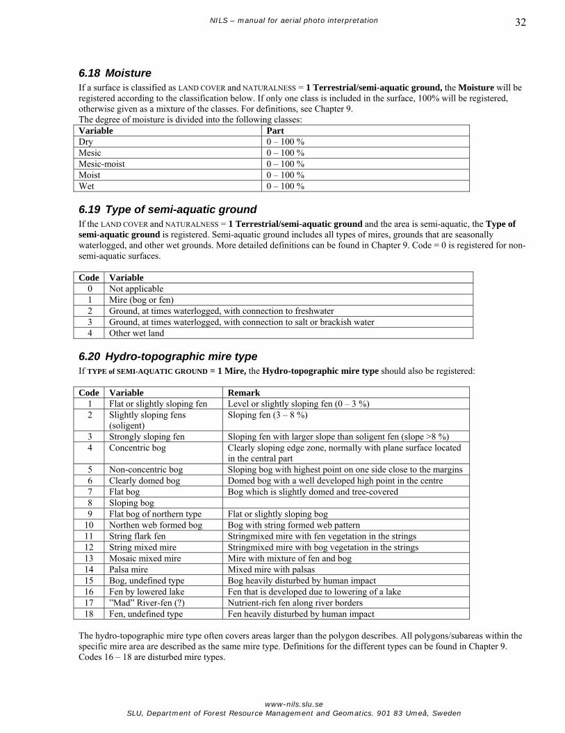
NILS – manual for aerial photo interpretation 32
6.18 Moisture If a surface is classified as LAND COVER and NATURALNESS = 1 Terrestrial/semi-aquatic ground, the Moisture will be registered according to the classification below. If only one class is included in the surface, 100% will be registered, otherwise given as a mixture of the classes. For definitions, see Chapter 9. The degree of moisture is divided into the following classes: Variable Part Dry 0 – 100 % Mesic 0 – 100 % Mesic-moist 0 – 100 % Moist 0 – 100 % Wet 0 – 100 %
6.19 Type of semi-aquatic ground If the LAND COVER and NATURALNESS = 1 Terrestrial/semi-aquatic ground and the area is semi-aquatic, the Type of semi-aquatic ground is registered. Semi-aquatic ground includes all types of mires, grounds that are seasonally waterlogged, and other wet grounds. More detailed definitions can be found in Chapter 9. Code = 0 is registered for non-semi-aquatic surfaces. Code Variable
0 Not applicable 1 Mire (bog or fen) 2 Ground, at times waterlogged, with connection to freshwater 3 Ground, at times waterlogged, with connection to salt or brackish water 4 Other wet land
6.20 Hydro-topographic mire type If TYPE of SEMI-AQUATIC GROUND = 1 Mire, the Hydro-topographic mire type should also be registered: Code Variable Remark
1 Flat or slightly sloping fen Level or slightly sloping fen (0 – 3 %) 2 Slightly sloping fens
(soligent) Sloping fen (3 – 8 %)
3 Strongly sloping fen Sloping fen with larger slope than soligent fen (slope >8 %) 4 Concentric bog Clearly sloping edge zone, normally with plane surface located
in the central part 5 Non-concentric bog Sloping bog with highest point on one side close to the margins 6 Clearly domed bog Domed bog with a well developed high point in the centre 7 Flat bog Bog which is slightly domed and tree-covered 8 Sloping bog 9 Flat bog of northern type Flat or slightly sloping bog 10 Northen web formed bog Bog with string formed web pattern 11 String flark fen Stringmixed mire with fen vegetation in the strings 12 String mixed mire Stringmixed mire with bog vegetation in the strings 13 Mosaic mixed mire Mire with mixture of fen and bog 14 Palsa mire Mixed mire with palsas 15 Bog, undefined type Bog heavily disturbed by human impact 16 Fen by lowered lake Fen that is developed due to lowering of a lake 17 ”Mad” River-fen (?) Nutrient-rich fen along river borders 18 Fen, undefined type Fen heavily disturbed by human impact
The hydro-topographic mire type often covers areas larger than the polygon describes. All polygons/subareas within the specific mire area are described as the same mire type. Definitions for the different types can be found in Chapter 9. Codes 16 – 18 are disturbed mire types.
www-nils.slu.se SLU, Department of Forest Resource Management and Geomatics. 901 83 Umeå, Sweden

NILS – manual for aerial photo interpretation 33
6.21 Hydrological mire type If the TYPE OF SEMI-AQUATIC GROUND = 1 Mire, the Hydrological mire type must be determined. The surface can be classified as a mixed mapping unit and the cover proportions of the categories below are given in percentages. If only one type is present, 100 % is registered. Definitions can be found in Chapter 9. Variable Percentage Lawn dominated by dwarf-shrub 0 – 100 % Other lawn 0 – 100 % Carpet 0 – 100 % Mud-bottom 0 – 100 % Flark pools 0 – 100 % Pools 0 – 100 % Swamp fen 0 – 100 %
6.22 Type of aquatic surface If LAND COVER and NATURALNESS = 2 Aquatic surface, the Type of aquatic surface is then registered under this header. Aquatic surfaces are divided into four classes with regard to salinity and existence of vegetation. For some of the categories there are attributes attached which describe the surface, e.g. pool and watercourse (Section 6.39). The surface delineation between aquatic and other land is estimated at the prevailing water level from the photo. Notice that the shore zone (semi-aquatic category, section 6.19) also should be mapped, i.e. the reclaimed/drained area up to normal highwater level. This means that a river furrow is delineated both at the border separating the bare substrate and the prevailing water level, and at the border between the ground vegetation and the bare substrate. If the delineated area between these two borders is too small or too thin, the shore zone is mapped as a line object if it meets the criteria (at least 5 m wide and 20 m long). Otherwise, the shore zone will be added to the adjacent terrestrial polygon. For mires on which there occur separate pools, which are too small to be mapped as separate polygons, the surface is described as Semi- aquatic ground and the proportion water surface is estimated (Section 6.21). Notice that this also is valid for areas with flark pools where each single flark pool can be over 0.05 ha while the strings between the pools are too narrow to be mapped as polygons. Smaller pools with water (less than 0.05 ha) in the alpine area and small pools of saline water trapped on land in coastal bedrock zones are also included in the percentage of Aquatic surface. Code Variable
1 Open freshwater 2 Fresh water with water vegetation 3 Open salt- or brackish water 4 Salt- or brackish water with water vegetation
6.23 Type of wetland vegetation If TYPE OF AQUATIC SURFACE = 2 Fresh water with water vegetation or = 4 Salt or brackish water with water vegetation, the Type of water vegetation should be registered according to the following standard: Code Variable
1 Belt formation of Phragmites australis, Typha sp. and Iris pseudacorus 2 Tall Carex species, Equisetum spp. and Scirpus lacustris 3 Floating-leaved plants 4 Other
There is some risk of mixing Code 1 and 2 since they are very similar. Phragmites australis and Scirpus lacustris may be especially similar when they grow in larger plant communities.
www-nils.slu.se SLU, Department of Forest Resource Management and Geomatics. 901 83 Umeå, Sweden

NILS – manual for aerial photo interpretation 34
6.24 Glacier or snow covered ground When LAND COVER and NATURALNESS = 3 Glacier or snow-covered ground, the ground is divided into three classes depending on the type of snow or ice cover: Code Variable
1 Glacier and other permanent snow and ice-covered ground 2 Occasionaly snow-covered ground 3 Incomplete snow cover (area with a mosaic pattern, where the vegetation cannot be interpreted)
6.25 Cover proportion on built-up area If LAND COVER and NATURALNESS = 6 Built-up area, the Cover proportion on built-up area is asked for. This comprises the cover percentage of buildings, artificial impervious ground, and substrate, etc, according to the standard below: Variable Cover proportion Buildings 1 – 100 % Artificial impervious ground 0 – 99 % Substrate 0 – 99 % Artificial green area 0 – 99 % Other/natural ground 0 – 99 % The BGD/GDS databases provide building data which is put into the NILS database as a separate layer. This separate layer is edited or added to if changes have occurred since the databases were compiled. In the building layer, each building is a polygon, and in the NILS database, information is added about type of building, such as dwelling house, old meadow barn, church or other building. The building layer is used to estimate the cover proportion of buildings in each NILS-polygon at a later stage. In some cases there is a risk of mixing artificial impervious grounds and substrate since they are reproduced with similar colours in IR-images. The differences are mainly of a textural kind: asphalt has a smooth surface, mineral soil has a relatively rough texture and a compressed gravel surface has an intermediate position with minor irregularities in the surface.
6.26 Land use Land use is judged in all cases. The current primary land use is registered for the delineated surfaces. The same land use can sometimes be registered for surfaces with totally different characteristics. One example may be an airport with an asphalted landing strip surrounded by grass. Moreover, there is often an area near the airport which is cleared of forest and is not influenced by human impact and has a natural character. In this case there will be one area with one land use class, but with three different land cover types. On wooded productive forestland, Forestry is registered if it is not likely that the land is used for other purposes. As mentioned before, the information regarding restrictions in land use is collected from external databases. If it is obvious that there is no current land use, the Code 0 = No visible land use is registered. One example may be regrowth on abandoned arable land. If the land use cannot be assessed, the Code 99 = Land use cannot be interpreted is registered. If none of the defined land use classes are suitable, Code 98 = Other land use, is preferred instead of forcing a surface into a class. The actual land use is registered in the notation column.
www-nils.slu.se SLU, Department of Forest Resource Management and Geomatics. 901 83 Umeå, Sweden

NILS – manual for aerial photo interpretation 35
Below is the complete list of land uses presented. For some land cover types, there is only a limited selection of accepted land use classes (section 6.27, 6.28, 6.29, 6.30, 6.31, 6.32, 6.33). Code Variable Code Variable
0 No visible land use 43 Industrial activities, trade, technical establishments
1 Forestry 44 Churchyard, burial ground 2 Forestry, area left for nature conservation
purposes 45 Petrol station
3 Seed orchard 46 Public service and activities 4 Powerline clearing strip 47 Public place, square 10 Arable land in rotation of crops 50 Road, vehicle parking 11 Grazed ley 51 Railway, railway yard 12 Ley for hay making 52 Airport 13 Field hard to classify 53 Harbour 14 Energy forest 60 Power station dam, magazine 15 Fruit orchard cultivation 61 Purification dam 16 Berry bushes 62 Fish-breeding, aquaculture 17 Other cultivation 63 Irrigation pond 18 Grazing (excl. pasture in arable field) 70 Sand and gravel pit 19 Enclosure for reindeer 71 Quarry, mine 30 Park (inclusive public lawns) 72 Peat workings 31 Golf course 73 Vegetable topsoil stripping 32 Slalom slope 77 (”Blocked number”) 33 Bathing site 80 Refuse dump 34 Camping 81 Sand, gravel, stone and soil deposits
(waste) 35 Stadiums and other buildings assigned
for exercises 82 Sedimentation pond
36 Other recreational area 88 (”Blocked number”) 37 Allotment cultivation, flowerbeds and
flower borders 90 Military command
40 Properties (outside urban areas) 97 Ongoing exploitation 41 Agricultural built-up area 98 Other land use 42 Agglomeration 99 Land use cannot be interpreted
It can sometimes be hard to evaluate the land use and to determine exactly where the border is to another land use. In these cases the interpreter will map the probable border and, as far as possible, follow any other existing borders.
6.27 Land use in arable land Land use in arable land is registered if LAND COVER and NATURALNESS = 5 Arable land. Code Variable Remark
10 Arable land in rotation of crops Annual crops and ley 11 Grazed ley Ley that is grazed 12 Ley for hay making Ley where cutting occurs intermittently or ley that is
recently cut in the images 13 Arable land hard to classify 14 Energy forest 15 Fruit orchard cultivation 16 Berry bush cultivation 17 Other cultivation Plant nursery etc.
www-nils.slu.se SLU, Department of Forest Resource Management and Geomatics. 901 83 Umeå, Sweden
NILS – manual for aerial photo interpretation 36
In this context Grazed ley means that the area is arable land which is grazed. The field structure remains and no shrubs or grass hummocks are forthcoming. Moreover, there should be no signs of a permanent pasture, such as animal paths or damage caused by trampling. In the latter two cases, the surface is classified as Terrestrial ground with the land use pasture. Ley for haymaking is registered when the ley is older and not grazed. This may be seen if parts of the ley are cut in the images and the remaining crop has an uneven colour than is usually the case for younger ley. It may also be visible if a recently cut ley has the colour tones which are indicative of new low vegetation (red) which is shorter than the cut vegetation (which has light beige colour tones). Arable land hard to classify is used if the surfaces have a field structure but the extent of cultivation is uncertain. Code 15 and 16 are commercial, large-scale fruit and berry cultivation on agricultural land.
6.28 Land use on artificial impervious/paved ground If a surface is classified as LAND COVER and NATURALNESS = 7 Artificial impervious/paved ground, the following classes are used: Code Variable
50 Road, vehicle parking 51 Railway, railway yard 45 Petrol station 43 Industrial activities 47 Public place, square 52 Airport 53 Harbour 35 Stadiums and other buildings assigned for exercises 36 Other recreational area
A bridge is delineated as a separate polygon attached with the attribute vertically over-laid (Section 6.39). In some cases the artificial impervious ground and substrate might be confused with each other since they have similar colours in the IR-images. The differences are mainly textural: asphalt has a plane surface, mineral soil has a relatively rough texture and a compressed gravel surface has an intermediate position with small irregularities in the surface. Recently laid asphalt has a very dark colour and is completely different from old asphalt.
6.29 Type of pit (land use) The type of pit is registered if LAND COVER and NATURALNESS = 8 Type of pit Code Variable
70 Sand- and gravel pit 71 Quarry/mine 72 Peat workings 73 Vegetable topsoil stripping
Vegetable topsoil stripping is only registered if it is possible to interpret this activity with high accuracy. It is an unsusual land use and can be mixed with tilled soil.
6.30 Type of waste (land use) Type of waste (land use) is registered if LAND COVER and NATURALNESS = 9 Waste. Code Variable
80 Refuse dump 81 Sand, gravel, stone and soil deposits 82 Sedimentation pond
www-nils.slu.se SLU, Department of Forest Resource Management and Geomatics. 901 83 Umeå, Sweden

NILS – manual for aerial photo interpretation 37
6.31 Land use on built-up area Land use on built-up area is registered if LAND COVER and NATURALNESS = 6 Built-up area. Code Variable Remark
40 Housing site Outside urban areas 41 Agricultural built-up area Including scattered dwelling houses 42 Agglomeration Densely built-up area with housing 43 Industrial activities, commerce/trading and technical
constructions
44 Churchyard, burial ground 45 Petrol station 46 Public service and activity 37 Allotment cultivation, flower beds and flower borders
(with buildings)
34 Camping A housing site is defined as ≤5 living houses together and also includes clearly delineated housing sites without buildings. Agglomeration means that at least 6 houses meant for living purposes are standing together with maximum of 150 m between them. Also densely built-up summer cottage areas are included in this category.
6.32 Land use on artificial green area Land use on artificial green area is registered if LAND COVER and NATURALNESS = 10 Artificial green area. Code Variable
30 Park (incluing public lawns) 31 Golf course 32 Slalom slope 33 Bathing site (manmade) 34 Camping 35 Stadiums and other buildings assigned for exercises 36 Other recreational area 37 Allotment cultivation, flower beds and flower borders (without buildings) 44 Churchyard, burial ground 50 Road, vehicle parking 52 Airport 90 Military command
6.33 Land use on aquatic surfaces Land use on aquatic surfaces will be registered if LAND COVER and NATURALNESS = 2 Aquatic. Code Variable Remark
0 No visible land use Normal case for aquatic surfaces 36 Other recreational area 53 Harbour 60 Power station pond, magazine 61 Purification dam 62 Fish-breeding, aquaculture 63 Irrigation pond 82 Sedimentation pond 90 Military command
www-nils.slu.se SLU, Department of Forest Resource Management and Geomatics. 901 83 Umeå, Sweden

NILS – manual for aerial photo interpretation 38
6.34 Historical land use Historical land use will be registered if LAND COVER and NATURALNESS = 1 Terrestrial/semi-aquatic ground, 2 Aquatic or 6 Artificial green area. Historical land use is registered if distinct evidence of previous land use can be observed. Code Variable
1 Forestry 10 Arable land 12 Hay-making 18 Grazing 70 Sand- and gravel pit 71 Quarry, mine 72 Peat pit 40 Property, industrial- or other built-up area 98 Other land use 99 Land use cannot be interpreted
6.35 Special cases – forestland/climate-induced non-productive land Forestland/climate-induced non-productive land is registered if LAND COVER and NATURALNESS = 1 Terrestrial/semi-aquatic ground. These categories are registered since they are interesting in many contexts and since they cannot directly be an output from previous registrations. Notice that unmanaged land and regrowth in abandoned agriculture land usually will be registered as forest according to the Swedish definition. In most of the cases this is seen in the aerial images since small broad-leaved trees and shrubs are visible and the field layer is relatively uneven. If Forestry, Forestry – area left for nature conservation purposes, or Seed orchard are given as LAND USE, the land is always considered to be forestland according to the Swedish standard. Code Variable
0 Not applicable 1 Forestland according to Swedish definition 2 Alpine areas according to NILS 3 Treeless climate induced non-productive land below tree limit
6.36 Measures taken, influence Measures taken, influence is registered if LAND COVER and NATURALNESS = 1 Terrestrial/semi-aquatic ground or 2 Aquatic. The variables in this section are closely related to registrations for management status or other more diffuse influences. In many cases the registrations will explain the appearance of a surface and give information which cannot be directly determined from other interpreted data. The description of measures taken gives information about different types of direct human influence. It is of major interest to follow how both natural processes and human activity influence the landscape. Forest measures like final felling and thinning of the forest stand will not be interpreted during the first interpretation. Such variables will possibly be assessed at the next assessment. Registration of final fellings may be derived from other registrations. Code Variable
0 No visible measure/influence 1 Ditched 2 Mechanic soil scarification in forestland 3 Ground disturbance from vehicles 4 Erosion, mainly by water 5 Erosion, mainly by wind 6 Slide 7 Burning/Fire 8 Hay-making 9 Managed, type of management not interpretable 10 Dredging
www-nils.slu.se SLU, Department of Forest Resource Management and Geomatics. 901 83 Umeå, Sweden

NILS – manual for aerial photo interpretation 39
6.37 Influence of grazing Influence of grazing is registered if LAND USE = 18 Grazing or 11 Grazed ley. This assessment comprises surfaces with grass or carex-dominated vegetation. In some cases there is land which more or less lacks vegetation due to damage caused by trampling (common in horse yards). In these cases the INFLUENCE OF GRAZING = 0 Void of vegetation due to damage caused by trampling, will be registered. Grazing surfaces which have small groups of taller herbs and are left surrounded by short grazed vegetation will be classified as shortly grazed. Code Variable
0 Void of vegetation due to damage caused by trampling 1 Shortly grazed vegetation (<5 cm) 2 Moderately grazed vegetation (5 – 15 cm) 3 Sparsely grazed vegetation (>15 cm)
Definition and interpretation instructions to the classes above can be found in Chapter 9.
6.38 Patterns in built-up areas Pattern in built-up areas is registered as LAND USE ON BUILT-UP AREA = 42 Agglomeration or 43 Industrial activities. In this section buildings and groups of buildings will be categorised according to the standard below. Mainly dwelling houses and other buildings which create a repetitive pattern over larger areas will be treated. Definitions of different types of buildings can be found in Chapter 9. Code Variable Remark
1 Built-up area with smaller houses, detached – planned structure
2 Built-up area with smaller houses, detached – non-planned structure
3 Semi-detached built-up area with smaller houses – planned structure
More or less semi-detached
4 Semi-detached built-up area with smaller houses – non-planned structure
More or less semi-detached
5 Extreme small housings/overnight cottages Allotment cottages, huts, church sheds, sheds in temporary fishing village
6 Lamellar houses/narrow block/deep block houses
Oblong detached houses for several families, 3 – 5 floors
7 Point block Moderately high to high solitary house bodies for varying purposes
8 Straight-line block Usually ≥6 floors high disc-shaped detached house bodies for varying purposes
9 Semi-detached straight-line block Semi-detached with lower houses 10 Open block 11 Closed block with few or no back-yard houses 12 Closed block with several back-yard houses 13 Block without yards (or with glazed yards) Common type by shopping centre, and in some
industrial and office environments 14 Temporary/mobile buildings Caravans, tents, barracks
www-nils.slu.se SLU, Department of Forest Resource Management and Geomatics. 901 83 Umeå, Sweden

NILS – manual for aerial photo interpretation 40
6.39 Attribute The item Attribute is for additional information that might be added to all polygons. This provides information on deviating structures in the landscape, such as ditch systems, macro patterns, and other phenomena that might have an importance for biodiversity. Code Variable Code Variable
0 Not applicable 20 Steep 1 Mosaic pattern 21 Scree 2 Ditch system 22 Soil liable to solifluctions with callus
formation 3 Natural water course 23 Soil liable to solifluctions with terrace
formation 4 Dug watercourse (or straightened) 24 Stone circles within the surface 5 Pond, natural/origin not interpretable 25 Tundra polygons within the surface 6 Dammed pond 26 Block streams 7 Dug pond 27 Frost-shattered blocky depressions
10 Flark pool 28 Frost-made soil polygons 11 Pool 40 Slope 12 Beaver pool 41 Noise protection bank 13 Flooded, temporarily covered by water 42 Vertically overlaid (on roof, bridge or
viaduct) 14 Flush within the surface 43 Ornamental pattern 15 Grass and sedge hummocks 44 Bedrock outcrop
6.40 Notation In this section it is possible to note any additional information. This can be done for all surfaces. Column for registration of comments.
www-nils.slu.se SLU, Department of Forest Resource Management and Geomatics. 901 83 Umeå, Sweden

NILS – manual for aerial photo interpretation 41
7 Mapping of line objects Line objects are mapped when the object is too narrow to be registered as a polygon. Minimum length is 20 m with different minimum widths occurring for different kinds of objects. The maximum width is normally 10 m, but roads and railways are always mapped as line objects independent of width. Watercourses are mapped as line objects when they are narrower than 6 m. Information about some line objects, such as width and cover proportion of trees and shrubs, is registered. The basic data set from Lantmäteriet (BGD/GDS) is used to map roads, railways, paths, watercourses and power lines. Adjustments to the BGD/GDS layer are made when obvious mistakes appear and when objects are missing (e.g., new roads) in the database. Along these line objects there is often a zone which is separate from the surroundings due to having a different land cover or land use. If this zone is not big enough to fulfil the requirements to be mapped as a surface, this zone may in some cases be mapped as line object; usually, however, this area is included in the line object. The line objects are mapped at the centre of the object. Alleys and tree rows are measured by the treetops. Ditches are mapped at their lowest point (ditch bottom). Notice that the line objects are placed in a separate layer in the database and are not mapped to be coincident with polygon surfaces. If a line object coincides with any polygon delineation, the polygon edge must be mapped as well. Line objects are not automatically polygon edges.
7.1 Transport routes Road widths are registered as attributes. Transport routes from the BGD/GDS layer are given a special attribute if they cannot be identified in the images for distances longer than 100 m. Code Line object Attribute Remark
1 Established road Width is registered, visible/invisible 2 Unconstructed track Visible/invisible 3 Established footpath/bicycle
road Visible/invisible
4 Major path (in open land) >1 metre width 5 Vehicle tracks (in alpine areas
and on mires)
6 Railway (embankment) 7 Smaller bridge 8 Plank walkway Path with footbridge 9 Timber boardwalk Row of logs on wet
ground, for vehicles
7.2 Enclosures In the aerial images, only stone fences, walls and major enclosures are mapped. Wildlife enclosures are not included in this group since they are too difficult to identify. Code Line object Cover of trees/shrubs Proportion
conifers 21 Stone fence 0 – 100 % 0 – 100 % 22 Other wall 23 Other major enclosure
www-nils.slu.se SLU, Department of Forest Resource Management and Geomatics. 901 83 Umeå, Sweden

NILS – manual for aerial photo interpretation 42
7.3 Vegetation strip Normally, the vegetation strip should be at least 5 m broad to be mapped as a line object. Vegetation strips that divide arable lands are mapped down to 2 m in width. The total cover proportion of trees and shrubs is registered as well as the proportion of conifers. Code Line object Cover of trees/shrubs Proportion conifer
31 Vegetation strip (width 2 – 10 m) 0 – 100 % 0 – 100 % 32 Tree corridor by clearing 0 – 100 % 0 – 100 %
7.4 Soil banks and banks Code Line object Cover of trees/shrubs Proportion conifer
41 Soil bank 0 – 100 % 0 – 100 % 42 Bank, mineral soil strip (zone more or less void of vegetation by water, 5 – 10 m broad)
7.5 Ditch/watercourse Ditches and watercourses (including the shore) are collected from the BGD/GDS layer and are completed or edited when needed. Ditches are constructed to lead water away, and are therefore very often straight with steep, straight edges. They are often surrounded by constructed banks, which are part of the total depth of the ditch. However, most often these banks are not affected by water. Creeks and streams are naturally occurring watercourses and, in most cases, the water flows in a naturally developed furrow, but sometimes the watercourses can also be straightened or cleared. Code Line object Cover of trees/shrubs Proportion
conifer 51 Smaller ditch/straightened water course (≤2 m) 0 – 100 % 0 – 100 % 52 Moderately sized ditch/straightened watercourse
(>2-6 m) 0 – 100 % 0 – 100 %
53 Ditch/straightened watercourse not visible in image
0 – 100 % 0 – 100 %
54 Creek (≤2 m) 0 – 100 % 0 – 100 % 55 Stream, larger creek (>2-6 m) 0 – 100 % 0 – 100 % 56 Creek invisible in image 0 – 100 % 0 – 100 %
Larger watercourses (>6 m) and water surfaces are delineated as polygons and are classified with land cover and land use variables, as well as attributes. The width of watercourses (which are mapped as line objects) includes the entire waterway around the watercourse. The width of a ditch is measured as the distance between the two outer edges of the ditch (Figure 14). Road ditches, i.e., ditches constructed at the same time as a road and which are included in a road area, are mapped as line objects. However, watercourses that cross a road are mapped in their entirety, including the parts that run along the side of the road for some distance. Smaller ditches on arable land (≤2m) along forest edges are treated the same way as road ditches; they are mapped only if they form a larger part of a watercourse.
Width of water _ furrow_____ Width of ditch________
www-nils.slu.se SLU, Department of Forest Resource Management and Geomatics. 901 83 Umeå, Sweden

NILS – manual for aerial photo interpretation 43
Figure 14. Principle for estimation of the width of a ditch.
Figure 15. Example of a ditch system, used in areas with commercial forestry. In this example only the double-drawn ditches are mapped, along with the outer screening-off ditches that enclose the area, and the creek in the top part of the figure. Normally, ditches delineate a border between arable land and forest. Since these borders are most often not visible in the aerial photos, they are only mapped if they constitute a part of a longer watercourse. However, major or moderate ditches/watercourses are always mapped. In areas with larger ditch systems, the many parallel ditches draining the clear-cut area towards the main central ditch are not mapped. In these cases the attribute “Ditch system” is given to the affected polygons (see Figure 15).
7.6 Manmade rows of trees and shrubs Avenues and tree rows are measured at the top of the object. An avenue can have one or several dead trees or gaps between trees and still be mapped as an alley. If a gap exceeds 20 m in breadth, the object is divided. Tree rows/avenues shorter than 20 m are marked as solitary trees when the trees fulfil the criteria for Broadly crowned solitary tree. Definitions for the objects above are found in Chapter 9. Code Line object
61 Row with broad-leaved trees (>70 % broad-leaved trees) 62 Row with conifer trees (>70 % conifer) 63 Row with mixed trees, (30 – 70 % mixture of conifer/broad-leaved trees) 64 Row with shrubs/Hedgerow (including small trees) 47 Broad-leaved avenue (>70 % broad-leaved trees) 48 Conifer avenue (>70 % conifer) 49 Avenue with mixed trees, (30 – 70 % mixture of conifer/broad-leaved trees)
www-nils.slu.se SLU, Department of Forest Resource Management and Geomatics. 901 83 Umeå, Sweden

NILS – manual for aerial photo interpretation 44
7.7 Lines etc. Lines are taken from the map database of Lantmäteriet (BGD/GDS) and are completed or edited when needed. A powerline clearing strip is mapped as a polygon if the width exceeds 10 m. Code Line object
51 Air cable, minor (with buffer zone) 52 Air cable, major (without buffer zone) 53 Underground line 54 Aerial railway, ski lift (including t-bar lift)
A minor air cable is assigned a width when the cable affects the land use and thereby the vegetation in the polygon. A major air cable means that the actual powerline-clearing strip is mapped only if it affects the land use. In the latter case, no buffer zone is connected to the line object since the land use is given in the polygon information.
7.8 Screes, steeps and artificial steeps If screes, steeps or artificial steeps have at least 20 m vertical difference from the surroundings and do not fulfil the area criteria for polygons, these objects are mapped as line objects. The concept artificial steeps refers to manmade mountain steeps. This class does not include gullies and steep sandy riverbanks. Code Line object
61 Scree 62 Steep, artificial steep (mountain steeps without developed slide zone)
7.9 Other line objects Code Line object
71 Jetties, piers 72 Dam construction 73 Artificial impervious shore line 74 Mound of stones in cultivated areas 75 Other line objects
All jetties and dam constructions, which do not fulfil the criteria to be mapped as a polygon are digitised as line objects. The software transforms all objects less than 20 m in length to point objects.
www-nils.slu.se SLU, Department of Forest Resource Management and Geomatics. 901 83 Umeå, Sweden

NILS – manual for aerial photo interpretation 45
8 Point objects Objects larger than 5 m2 and less than 0,05 ha (about 22 x 22 m) in area are defined as point objects. Usually point objects are measured at the centre and tall objects are measured at their peak.
8.1 Broadly crowned solitary tree Broadly crowned, solitary trees are mapped as point objects on all land except where the land use is forestry. One tree is registered as a solitary tree if it is clearly isolated and not more than 25 % of the tree crown touches other tree crowns. In this class, broadly crowned solitary trees belonging to an avenue, planted rows of trees or “stand-forming tree species” are not included. Stand-forming trees are considered to occur when the crown cover of the broadly crowned trees reaches 30 %, and at least 5 broadly crowned trees (including broadly crowned but not solitary trees) grow in the same area. A few broadly crowned trees growing in a smaller area, for example, in a field islet, which cover more than 30 % of the small area, are not considered to be stand-forming in this context; in this case, the trees are mapped as point objects if they fulfil the criteria. Trees are mapped at the centre of the object, at the highest point/tree top. If a broadly crowned solitary tree is growing on or nearby another point object, both of the point objects are mapped, even if the other point object has the attribute “with trees and shrubs” (see Biotope islet Section 8.2). For southern Sweden (stratum 1 – 6) the crown width of broad-leaved trees has to reach ≥15 m and for conifers ≥7 m. For northern Sweden (stratum 7 – 10) the crown width has to reach ≥7 m for both groups. Code Point object
1 Broadly crowned broad-leaved tree 2 Broadly crowned coniferous tree
8.2 Biotope islet A biotope islet is a surface covered entirely or partly by vegetation and is surrounded on all sides by arable land/ley, paved/artificial impervious ground or road. An island is a biotope islet in water. Islands and field islets are the most common types. These are mapped as point objects if they are smaller than 0,05 ha. If a tree fulfils the criteria for being a “Broadly crowned solitary tree” on a biotope islet, the tree is mapped as a separate point object. Code Point object
5 Biotope islet without trees and shrubs 6 Biotope islet with trees and shrubs 7 Small island without trees and shrubs 8 Small island with trees and shrubs 9 Small island without vegetation
8.3 Mound of stones/boulder/rock outcrop Manmade mounds of stone, big boulders and bedrock outcrops are mapped if they are surrounded on all sides by arable land/ley, paved/artificial impervious ground or road (cp. Biotope islet Section 8.2). These objects are also mapped if they are situated on or directly beside another point object in these environments. If a bedrock outcrop is situated in a field islet, which is less than 0,05 ha, both are mapped as point objects: one in the centre of the field islet, and the other at the centre of the rock outcrop. (If the field islet is more than 0.05 ha, it will be mapped as a polygon and the rock outcrop is registered as part of the substrate.) If a tree fulfils the criteria for “Broadly crowned solitary tree” and is situated nearby the object, the tree is also mapped. Code Point object
11 Mound of stones/boulder/bedrock outcrop without trees and shrubs
www-nils.slu.se SLU, Department of Forest Resource Management and Geomatics. 901 83 Umeå, Sweden

NILS – manual for aerial photo interpretation 46
12 Mound of stones/boulder/bedrock outcrop with tree and shrubs
8.4 Ponds, wetlands, wells Ponds are mapped as point objects if the water surface is at least 5 m2 and not more than 0,05 ha (about 22 x 22 m) for a longer period of the year. Temporary ponds formed after rains are not included here. Bigger ponds (mapped as polygons) were, during 2003, automatically classified as small ponds in order to facilitate a special field inventory directed towards all smaller water bodies. Strata 8 –10 were exempt from this special inventory. Code Point object
21 Ponds, without trees and shrubs 22 Ponds with trees and shrubs 23 Wetland in agricultural land, without trees and shrubs 24 Wetland in agricultural land, with trees and shrubs 25 Well
8.5 Pit, waste Pits and wastes less than 0,05 ha are mapped as point objects. The type of pit or waste is not registered in this case. Code Point object
31 Pit without trees and shrubs 32 Pit with trees and shrubs 33 Wastes
8.6 Buildings Houses or other building constructions with a surface of at least 5 m2 are registered as point objects. The building may be damaged but at least a greater part of a wall or roof should be left. Buildings are collected from the BGD/GDS layer and are mapped as polygons except for wind power stations, towers, and masts, which are mapped as point objects. Code Point objects
40 Dwelling house 41 Old meadow barn 42 Partly damaged old meadow barn 43 Other building 44 Church 44 Wind power station 45 Tower or mast
8.7 Building constructions in water Landing stages and jetties by water are almost always mapped as line objects; however, jetties with a surface of at least 5 m2 and shorter than 20 m are automatically transformed by the software to point objects. The reference point refers to the point where the jetty is attached to the ground and is digitised as the first point. The end of the landing stage in the water is digitised as the second point and indicates the direction of the symbol. Dam constructions are treated in the same way. Code Point object
71 Minor jetties (shorter than 20 m) 72 Minor dams (shorter than 20 m)
www-nils.slu.se SLU, Department of Forest Resource Management and Geomatics. 901 83 Umeå, Sweden

NILS – manual for aerial photo interpretation 47
9 Definitions and interpretation guide In this section there are definitions to some of the concepts that occur in the previous text. In some cases there are interpretation instructions for the issue in question. Definitions and interpretation instructions will be updated continuously during the work and added to the next version of the manual. The definitions are, to a major extent, organised according to the structure in this manual. Section 1.3 Breeding Bird Survey The Breeding Bird Survey is a programme, which organises the monitoring of breeding birds (and non-migratory birds during wintertime) on a voluntary basis. The most important methods are:
1. Point survey: the inventory crew member chooses an arbitrary route and stays for five minutes at 20 different points and counts all heard and seen birds. This is accomplished once a year in the summertime and one to five times during the winter using the same type of routes.
2. Fixed standard route: a quadrate of 2 x 2 km is formed and all birds along the edges are noted (line survey once a year in the summer) and stops are made every five minutes at eight fixed points (point surveys).
Section 3.1 General about the delineation A-posteriori A-posteriori (lat., e.g. 'from the latter [part]'), built on experiences. Knowledge (also concepts and statements) are a-posteriori if it (they) are dependent on experience. We cannot know if the sentence “the table is brown” is true without perceiving the table. Furthermore, this type of knowledge is contingent, i.e., its truth is temporary and not necessary. The contrary is a priori (source: Swedish National Encyclopaedia). In this manual, the “a-posteriori principle” means that some classifications are made after delineation. A-priori A-priori means decided on beforehand, and without any further investigation (source: Swedish National Encyclopaedia). Section 4.1 Overview of the photo interpretation work For Aquatic surface and Semi-aquatic ground, see definitions in Section 6.1 Section 4.2 Principles for delineation of polygons Aquatic surface See definitions in Section 6.1. Artificial surfaces Artificial surfaces are where the ground surface is affected by human activity and where the land use implies that any occurring vegetation is dependent on, to a large extent, the current land use. This can be the case with arable land, artificial impervious ground, established housing sites and parks, pits, and wastes. Natural properties and over-grown land are not included here, but belong instead to “Terrestrial land”. Impervious ground See definitions in Section 6.1. Management See definitions in Section 6.1. Agricultural land Definition: Agricultural land in this context means arable land, pasture and ley for hay-making etc. (see following). Recently abandoned agricultural land with emerging regrowth is also included here. When shrubs and smaller trees have
www-nils.slu.se SLU, Department of Forest Resource Management and Geomatics. 901 83 Umeå, Sweden

NILS – manual for aerial photo interpretation 48
reached a mean height, which exceeds 3 m and crown cover exceeding 70 %, the land is not considered to be agricultural land any longer. Macro pattern Definition: A pattern which is repetitive within larger areas, e.g., buildings in an area with terrace houses. Semi-aquatic ground See definitions in Section 6.1. Arable land Definition: Regularly ploughed ground with a rotation of crops, including annual crops, ley for hay-making and grazed ley. Arable land includes also other cultivations on previously ploughed/cultivated land, such as energy forest and fruit-/berry cultivations. Only large-scale cultivation is included in this definition. Smallers lots on housing sites (e.g., a small potato lot) is not defined as arable land. Arable land planted with trees which normally grow in forests is not defined as arable land, but as forest. Periodically ploughed grazed ley (included in rotation of crops) is, in other words, included in arable land. On the other hand, permanent pasture is not covered in this definition. The easiest way to interpret this in the images is to notice when tracks from the plough are no longer visible on the ground and vegetation. Interpretation guide: See the interpretation guide for arable land in rotation of crops, grazed ley, ley for hay-making, field hard to classify, berry bush and fruit orchard cultivation. Section 6.1 Land cover and naturalness Aquatic surface Definition: Aquatic (lat. aqua´ticus 'which aims at water', of a´qua 'water'), belonging or formed in water. Aquatic environments are running water, fresh water, brackish water or marine locations (source: Swedish National Encyclopaedia). During interpretation, all surfaces covered by water at the time of imaging belong to the aquatic environment. Exceptions are areas flooded from periodically and established/tiled pools. In power station ponds/magazines, the entire area clearly affected by water is considered to belong to the aquatic surface. Artificial green area Definition: An artificial green area is vegetation-covered ground established though digging or excavating, and may include some visible soil. Objects such as established ditch-banks and headlands along arable lands and roads, green lawns in parks or housing sites, golf courses, etc., are included. Other established areas used in recreational purposes belong here, e.g., flower beds, flower borders and allotment cultivation, although artificial impervious surfaces are exempt. Pits are not included here either, but instead belong to natural land exploited occasionally. Built-up area Definition: A built-up area refers here to areas with buildings where the surrounding area is affected by the activity associated with the buildings. Scattered buildings in agricultural areas (except for dwelling houses, old meadow barns, huts in the forest, etc.) whose immediate surrounding does not differ from the other surrounding land are not considered to stand on built-up area. Dwelling houses, including summer cottages, are always considered as a built-up area, even if the building site has a natural character. During the photo interpretation, an assessment is made of the built-up area’s cover proportion of buildings, artificial impervious ground, substrate, artificial green area and other/natural land. Waste Waste refers to storage spaces for refuse. During photo interpretation, a differentiation is made between refuse dumps, sedimentation ponds, and wastes for sand, gravel, stone, and/or soil deposits. Glacier Definition: A glacier is an accumulation of snow and ice that moves due to its own weight. When the thickness of the ice is about 30 m, the pressure from the above layer is so large that the stress exceeds the inner strength of the ice. A slow deformation movement – creeping -- occurs in the ice accumulation and a glacier develops. (source: Swedish National Encyclopaedia).
www-nils.slu.se SLU, Department of Forest Resource Management and Geomatics. 901 83 Umeå, Sweden

NILS – manual for aerial photo interpretation 49
Artificial impervious paved ground Definition: Artificial impervious paved ground is ground with a more or less permanent cover, which prevents colonisation of vegetation. It is mainly asphalted surfaces, but can also be paved ground, ground covered with gravel/macadam (open space with gravel, or a railway embankment) or concrete (mast bases, etc.). Semi-aquatic ground Definition: Semi-aquatic ground in this case means mires, periodically covered with water, or other wetlands. Mires are defined as a bog or a fen or a combination of these (see also definition for mire and the different types of bogs and fens). Periodically water-covered grounds constitute the flooding zone where the water level regularly shifts between flooding and reclamation. Eroded substrate is included here, such as areas along exposed beaches, which are primarily eroded by waves and ice, or areas such as bedrock shorelines. Also drifting banks of seaweed, and the like, may occur. The exposed substrate is also often clearly mixed with, or covered by sediment or mud. Exceptions are wind-affected sand dunes, where exposed sand can occur considerably higher than the high-water level due to wind erosion. Terrestrial ground Definition: Terrestrial (lat. terre´stris, from te´rra 'soil'), which has something to do with the earth (often in contrast to other celestial bodies) (source: Swedish National Encyclopaedia). By terrestrial ground means, in this case, all ground except the aquatic and semi-aquatic environments (see definitions of aquatic surface and semi-aquatic ground). The terrestrial ground is, during the photo interpretation, divided into artificial ground and other terrestrial or natural/semi natural ground. Snow covered ground Definition: This is ground covered with snow at the time in which the photograph was taken. Pit Definition: A pit includes pits for sand, gravel, peat workings, vegetable topsoil pits, quarries and mines (opencasts) with ongoing mining. Pits, which have been closed down, are not included. Arable land See definitions in Section 6.27 Land use Section 6.3 Substrate cover Substrate See definitions in Section 6.4 Section 6.4 Type of substrate Bedrock Definition: Bedrock is an exposed rock outcrop, which is lacking vegetation or is covered with crustose lichen, foliose lichen or mosses growing on rocks. Only the part where the humus layer is missing is considered as exposed. Boulder ground Definition: Boulder ground is ground with exposed boulders (>20 cm) where the boulders lack vegetation, or are covered with crustose lichen, foliose lichen or mosses. Only the part of these grounds where the humus layer is missing is considered to be exposed.
Mineral soil Definition: Mineral soil is exposed mineral soil, including stones (<20 cm), which is lacking vegetation or is covered with crustose lichen or ruderal mosses. Only the part of these grounds where the humus layer is missing is considered to be exposed. Grey-brown podzol and cultivated soil are also included in this category where mineral soil and topsoil are mixed.
Substrate Definition: Substrate is the ground or material that plants, fungi, lichens, bacteria and some invertebrate animals grow or live on or in (source: Swedish National Encyclopaedia).
www-nils.slu.se SLU, Department of Forest Resource Management and Geomatics. 901 83 Umeå, Sweden

NILS – manual for aerial photo interpretation 50
During the photo interpretation in NILS a separation is made between bedrock outcrop, boulder, mineral soil (including stone, gravel and grey-brown podzol) and peat/humus. Peat and humus Definition: Peat and humus is defined as exposed peat/humus, i.e., substrate, which is dominated by partly decomposed organic matter with no or inconsiderable elements of mineral soil, and where parts of the flora and fauna have lost a great part of its original structure. This is not estimated on grey-brown podzol or topsoil. Humus is an organic substance in a decomposition phase. As a consequence of the activity of the microorganisms in the ground, the litter gradually loses its original structure and is transformed into humus. Peat is a type of soil that is rich in humus with an organic origin that has developed from the partial decomposition of plants and animals. Peat is developed in shallow watercourses or in waterlogged ground where dead biomass is prevented from complete mouldering due to lack of oxygen. Peat is usually saturated with water for a majority of the year. Section 6.6 Type of deviating main type/land cover class General about deviating main type/land cover Definition: Deviating main type/land cover means the deviating parts within a delineated polygon. Mire (bog or fen) See definitions in Section 6.20
Section 6.7 Tree layer Scattered trees Definition: The class “Scattered trees” is delineated when a surface has ≤10 trees per hectare. The class implies that no tree height measurements are made during the photo interpretation. If the surface is smaller than 0,1 ha, the limit is ≤20 trees/ha; for example, a surface on 0,1 ha with two trees is considered to belong to the class “Scattered trees”. Two-layered tree stand Definition: For photo interpretation in NILS, Two-layered tree stand means that two layers, both of which are possible to measure in the image are visible. The intention is to facilitate and improve the description of two-layered tree stands. To register layered stands the difference between mean heights of the two layers has to be at least 1/3 of the overstorey’s mean height. The overstorey has to consist of at least 10 trees/ha. When the number of stems within the surface is sparse, they should be fairly scattered and not stand too closely together. Section 6.8 Tree height Basal area mean height Definition: Basal area mean height is a weighted mean value for the height of the trees, where the weight is the basal area of the individual tree. The basal area of the individual tree is its intersectional area at breast height. This type of mean is used rather than an arithmetic mean, so that the stand’s mean height will reflect the average of the bigger trees rather than the average of the (sometimes abundant) undergrowth which is of less interest from both an ecological and economic perspective. Since smaller trees are, in many cases, hard to take into consideration when estimating a stand’s mean height from aerial photos, the basal area mean height is thus preferred. Basal area mean height, hgv, is estimated according to the following formula:
hgv =
∑
∑
∑
∑
=
=
=
= = n
n
i
i
n
i
i
n
ii
n
iii
d
hd
g
hg
1
21
2
1
1
4
4π
π
,
www-nils.slu.se SLU, Department of Forest Resource Management and Geomatics. 901 83 Umeå, Sweden

NILS – manual for aerial photo interpretation 51
where gi, hi = the ith tree’s basal area (cross-sectional area at breast height) with respect to height. Interpretation guide: For photogrammetric measurements of the mean height, greater focus will be placed on taller trees which almost always correspond to trees with the largest volume. In this part, a subjective estimation is made regarding the location for mean height of the canopy. Section 6.9 Tree cover Tree cover The tree cover (or crown cover) for an object is that part of the object that is covered by tree crowns in relation to the entire object. In layered stands the overstorey dominates over the understorey (i.e., the total cover proportion cannot exceed 100 %). The so-called soft or diffuse crown cover is considered here, meaning that the cover of a tree crown in principle is the orthographic projection of the entire tree crown onto the ground, including any gaps in the crown. During photo interpretation, any line- and point objects within the surface are included in the estimation, as well as half of the crown cover of trees bordering to adjacent surfaces. The cover of the border trees has, in practicality, influence only on surfaces with sparse tree vegetation, such as a ditch with trees which separates two arable land areas. If an area without trees is adjacent to an area with trees, the border trees are considered to belong to the area with trees (if it is not obvious that the trees grow on the area which otherwise lacks trees). Line objects that have buffer zones (mainly roads and wires) are not included in the tree cover estimation. These surfaces lack trees and both line object and buffer zone are excluded. Tree cover is harder to estimate correctly in the corners of the stereoscopic model because of the ever-increasing relief displacement from the centre of the photograph out to the corners. Section 6.10 Areal distribution of trees, Macro pattern Areal distribution, Macro pattern This refers to area distribution or the spatial distribution of the trees over a delineated surface. During photo interpretation, some categories are registered (Figure 12). In most cases the pattern is a random distribution, but when this is not the case, a clearly defined pattern should be seen in the images in order to assign this attribute. Section 6.11 Composition of tree species ”Trivial” broad-leaved tree species “Trivial” broad-leaved tree species are all broad-leaved trees that are not defined as deciduous hardwood (see Deciduous trees). Composition of tree species Definition: The composition of tree species as interpreted in NILS considers the proportion of the total crown cover in a stand for each tree species, or group of tree species. During photo interpretation, the following tree species (tree species groups) are separated: pine, spruce, “trivial” broad-leaved tree species, dead trees, beech and other deciduous trees. In a two-layer stand, the composition of tree species is interpreted separately for each tree layer. For each tree species or tree species group, the crown cover is interpreted as a percentage of the layers’ total crown cover. If the layer consists of one tree species, this tree species constitutes 100%. Since forests dominated by deciduous trees often have undergrowth of spruce, and since broad-leaved trees are easier to detect in IR-images, the photo interpretation of the percentage of broad-leaved trees will be overestimated in many stand types in relation to field measurements of basal area or volume. Dead trees are sometimes hard to identify, in part due to the small area they often cover, in part because of the taller trees that hide them. Therefore, the proportion of dead trees will probably be underestimated in comparison to the field measurements.
www-nils.slu.se SLU, Department of Forest Resource Management and Geomatics. 901 83 Umeå, Sweden

NILS – manual for aerial photo interpretation 52
Interpretation guide: The colour of Coniferous trees in IR-photography varies a lot. They are often depicted as reddish brown, purple or bluish-green in the images. Pine and spruce can have different colour shades, but usually there is only a slight difference or no difference at all. In older stands clearly dominated by one of the tree species, spruce forest is usually depicted in darker hues than the pine forest, mainly due to deeper and longer shadows. Forests of different ages have well-defined differences between the colours; normally, the younger they are, the redder they appear. Both the field layer and the tree layer influence the general colour impression of the forest stand. Field layers with lichens are depicted in blue colour tones, mosses together with dwarf-shrubs appear to be reddish-brown and grass/herbs appear clearly in red colour tones. Recently clear-felled areas are bluish-green, maybe with elements of red from shrubs and young broad-leaved trees. The older the clear-felled area is, the more often elements of red and sometimes yellow occur (due to shrubs, small broad-leaved trees, and grass/herbs such as Deschampsia flexuosa and Epilobium angustifolium). The height of the trees depends on age and site quality. Stands with the average height of 30 m can occur on sites with high qualities, but are rare. Coniferous forest below 3 m, which correspond to plantations or recently cleared forest, are considered belonging to the shrub layer and is principally not included in the composition of tree species. Most of the coniferous forests today are planted, young or middle-aged forests and are therefore of the same age and have about the same height within the stand. The structure in the canopy is uniform to uneven and the stands are often striped as a consequence of soil scarification/planting or thinning. The old forests usually have more uneven canopies and more irregular structure. Broad-leaved trees are clearly redder than coniferous trees. The structure is often irregular and heterogeneous, due to the different height of the trees. The broad-leaved trees seldom grow uniformly scattered in the coniferous stands. They are usually found in a broad zone along arable lands, old meadow and grazing areas, in small groups along forest edges (e.g., clones of aspen (Populus Tremula)), or in narrow courses along watercourses and drainage passages of alder (Alnus Glutinosa) or downy birch (Betula Pubescens). Do not mix up the following types: Mixed forest and deciduous forest. The proportions of deciduous forest/coniferous forest can be hard to detect. It is easy to overestimate the proportion of broad-leaved trees and cover proportion. Deciduous trees have a wide rounded crown in the canopy compared to spruce which has a small and pointy crown in the canopy. Young coniferous forest overgrown by a major part of broad-leaved trees can be mistakenly interpreted as deciduous forest. A uniform canopy and a darker colour shade may give a clue as to the presence of the coniferous trees. Growth of younger coniferous trees under broad-leaved trees is often not discovered. Deciduous hardwood The category deciduous hardwood includes oak (Quercus sp.), elm (Ulmus glabra), European ash (Fraxinus excelsior), maple (Acer platanoides), linden (Tilia sp.), hornbeam (Carpinus betulus), wild sherry (Prunus avium) and beech (Fagus sylvatica). Section 6.13 Occurrence of broadly crowned trees Broadly crowned trees Trees are considered to have a broad crown if their crown diameter exceeds the measures below: Southern Sweden (stratum 1 – 6): crown width limit for broad-leaved is ≥15 m and for conifers ≥7 m. Northern Sweden (stratum 7 – 10): crown width limit for both groups is ≥7 m. Section 6.14 Cover of shrubs and smaller trees Cover of shrubs Definition: The shrub cover proportion refers to diffuse crown cover and is estimated as the part of a surface that is covered by shrubs or smaller trees below 3 m height. (This differs from the field inventory where strict cover is estimated.) All wooded vegetation below 3 m is estimated as belonging to the shrub layer, except for alpine birch forest where the tree species belongs in the tree layer even if the mean height is 2 m. In many cases the difference between smaller trees and shrubs is hard to estimate in aerial photos. Because of this, the height of the layer is used as an indicator to estimate whether a surface is covered by trees or shrubs.
www-nils.slu.se SLU, Department of Forest Resource Management and Geomatics. 901 83 Umeå, Sweden

NILS – manual for aerial photo interpretation 53
Section 6.15 Areal distribution of shrubs and smaller trees, macro pattern Areal distribution, macro pattern See Section 6.10 Section 6.16 Conifer proportion of shrubs and small trees Definition: Canopy cover proportion of coniferous shrubs and smaller trees is defined as the proportion of shrubs and smaller trees that is made up of coniferous shrubs and smaller tree species. The coniferous proportion is given as a percentage of the diffuse cover proportion. Interpretation guide: Juniper shrubs (Juniperus communis) appear as very small purple-bluish mauve spots and rarely reflect shadows. The most common size of junipers is about 1 m in diameter and 1 – 2 m tall; this size is near the limit of the resolution capacity of the film and shadows are not always reflected at this height. The biotope is the most important interpretation indicator. Juniper shrubs grow on dry slopes and dry meadows, and often on thin soil cover, but also on boulder moraine or on coarser sediments. They may also occur on dry to mesic grounds. Since the colour of the juniper shrubs is bluish mauve in the photos, they differ slightly from the blue colour of the ground in these biotopes and can thus be detected. Junipers are only easy to interpret once they have grown quite tall or occur in dense groups. In these cases they appear in a very dark colour, which makes them very easy to interpret. Smaller conifer trees appear purple coloured. These dark spots differ from the red colour of the agricultural landscape. Naturally regenerating smaller trees grow in scattered, irregular patterns in contrast to coniferous plantations that grow in straight rows. Section 6.17 Field layer and ground layer General information about field layer and ground layer On open ground of natural or semi-natural character, the ground is delineated in homogenous units according to the dominance of species in the field and ground layer. Also, grounds with a sparse cover of trees or shrubs have an impact on the delineation. If a field layer exists, the ground layer is usually not visible in the aerial photographs. One exception in this respect is lichen-rich ground where it is often possible to see the lichen in a field layer consisting of dwarf-shrubs; this is called dwarf-shrub type with lichen. Dwarf-shrub type with herbs is an intermediate class between grass-dominated ground and dwarf-shrub dominated ground and is, in most cases, a mixture between Vaccinium myrtillus and Deshampsia flexuosa. Indicators for interpretation: Colour, structure and ecological position such as topography, landforms, geographic extension and exposition of light. Ground layer Definition: The ground layer consists of mosses, arbuscular and foliose lichens growing on ground or stone. Bare or artificial impervious ground, water/snow covered ground, shrub and tree stumps, droppings, and coarse and fine litter constitute the ground layer. It is an imaginary two-dimensional layer that covers about 100% of the surface. During photo interpretation, a simplified estimation is made of the ground layer at the same time the field layer is estimated. Field layer Definition: The field layer includes all plants that are types of ferns, herbs, dwarf-shrubs, graminids and dead branch wood (dead shoots and twigs). All living leaves and shoots are included, as well as dead parts or parts that recently have turned yellow. The estimation of the field and ground layer is done simultaneously during the photo interpretation. Field layer dominated by grass or herbs Definition: In this case, grass and herbs dominate the field layer and the ground layer consists of mosses. The grass types occur in different moisture classes. In the dry meadows in the agricultural landscape, some low thin-leaved grass types and a few herbs grow. In the mesic meadows, medium tall broad-leaved grass types and many species of herbs grow. Mesic meadows have, depending on management and grazing regime, either low growth of Carex and grass species with low herbs or very tall herbs, grass- and Carex species.
www-nils.slu.se SLU, Department of Forest Resource Management and Geomatics. 901 83 Umeå, Sweden
NILS – manual for aerial photo interpretation 54
Interpretation guide: For agricultural areas, the colour is clearly red but can have blue to dark red elements depending on moisture and cover proportion. The structure is uniform or uneven depending on current cultivation activities. The occurrence of this type of field layer is independent of topography, but is most common on flat ground and in low terrain. Dry grass areas also occur on moraine ground, on grounds with thin soil layer and around rock outcrops. On forestland, the herb type occurs on mesic to moist fertile soils. The tree layer is often dense and the shrub layer can be densely developed. Usually spruce dominates and the proportion of broad-leaved trees is often striking. Older forest of the herb type reaches substantial height, sometimes greater than 30 m. The herb types are mostly developed on grounds with mobile soil water or on soil with lateral water flow, e.g., on the lower parts of a slope. In pine forest, the herb type with grass mainly occurs in eastern Sweden, e.g., on the limestone grounds of Gotland. In plantations on abandoned arable land, the field layer of the herb type with grass is also found. On open forestland, broad-leaved grass types and herbs are seen as reddish and pink colour shades in mid-summer photos while thin-leaved grass types usually display more tones of blue due to the lower cover proportion. Blooming Epilobium angustifolium and ripe, thick Deshampsia flexuosa are depicted in yellow tones. In thicker forest stands, the different types are mainly identified according to the topographic and the ecological position. In addition, the tree species present can give information as to the type of field layer. Do not mix up the following types: Grass type with arable land and ley; grass and herbs with shrubs and small broad-leaved trees; grass with dwarf-shrub type. Grass with dwarf-shrubs Dwarf-shrubs Definition: The field layer consists of low grown dwarf-shrubs, dry thin-leaved grass and a few herbs. In the ground layer, mosses and lichens grow. The types of dwarf-shrubs that occur on grazing grounds are usually dominated by Calluna vulgaris but other types of dwarf-shrubs with Vaccinium myrtillus and Vaccinium vitis-idaea are also common. Dwarf-shrub types dominated by Empetrum nigrum occur particularly in northern Sweden while moist heaths dominate in western Sweden. Interpretation guide: Grounds dominated by heather (Calluna vulgaris) can be interpreted with direct interpretation indicators. Calluna vulgaris has a striking dark brown to reddish-brown colour and a coarse surface texture. The cover proportion varies from full cover of Calluna vulgaris to scattered expanding spots of Calluna vulgaris in grassy areas. Calluna vulgaris occurs on nutrient-poor and dry to mesic grounds. On grounds such as sand or areas with bedrock outcrops, the heath vegetation is clearly seen in contrast to the bluish colour of the ground. In grass vegetation, or where large patches of Pteridium aquilinum occur, the dispersed Calluna vulgaris gives only a weak brownish tone to the otherwise red field layer and can therefore be difficult to detect and interpret. The dwarf-shrubs Vaccinium myrtillus and Vaccinium vitis-idaea are difficult to detect in grassy areas. It is hardly possible to discern the dwarf-shrubs by colour since their dark red to reddish-brown colour tones are very similar to the colour of the grasses. However, the texture seen in dwarf-shrub dominated ground is somewhat more irregular and coarser than for grass grounds. Dry and mesic dwarf-shrub types of heath are the most common forest types in Sweden. They grow on sites with poor to medium nutrient qualities. The tree layer usually consists of pine on dryer ground and spruce on mesic ground. In the field layer, the plants Vaccinium vitis-idaea and Vaccinium myrtillus dominate. Crown density can be high. Dwarf-shrub heaths are the most common types on moraine and coarser sediments, and occur over the entire country. In forest stands it is usually not possible to see the field layer due to the dense forest. In these cases, the interpretation has to be made with help from indirect factors such as location in the terrain, tree species and landforms. The location of the forest in question is compared with other surfaces on clear-cut areas or areas with young forests. When doing this kind of comparison, it is important to remember that grass is favoured in open surfaces, and natural Vaccinium myrtillus forest grounds tend to change to a grass type once the tree stand becomes thinner. On moraine grounds, the dryer dwarf-shrub heaths grow on the hillcrests and the mesic dwarf-shrub heath grows on the hill slopes. Therefore, soil type maps may give guidance.
www-nils.slu.se SLU, Department of Forest Resource Management and Geomatics. 901 83 Umeå, Sweden

NILS – manual for aerial photo interpretation 55
Moist and wet dwarf-shrub heaths occur mostly on peat grounds, but also on alluvial sediments and fine sediments in depressions and on the lower part of slopes. The tree layer consists of pine and spruce, often with a high degree of broad-leaved trees, such as downy birch or alder. The field layer consists of tall-grown dwarf-shrubs such as Vaccinium uliginosum, Rhododendron tomentosum or Myrica gale and different Equisetum and Carex species. Do not mix up the following: Dwarf-shrubs with junipers or young pine plants; dwarf-shrub with grass type; Calluna vulgaris heath with clear-cut area. Lichen and Dwarf-shrubs in mixture Definition: The field layer consists of dwarf-shrubs such as Empetrum nigrum, Calluna vulgaris and Vaccinium vitis-idaea and the ground layer consists of lichens. The mixture of the whitish-grey lichens among the dwarf-shrubs is often visible in the images. Interpretation guide: This type occurs on dry nutrient-poor soils. On forestland, the associated tree layer is dominated by pine and is relatively sparse. The dryer and more nutrient-poor the soil is, the thinner the tree layer becomes. It is a common vegetation community on coarse soil types in northern Sweden. The ground is depicted in a light bluish-grey colour. It can be mixed with lichen type but usually has a denser tree layer and occurs particularly on other landforms. Do not mix up the following: Lichen and dwarf-shrub in mixture with lichen type. The mixed type is darker than the lichen type and the dwarf-shrubs are often clearly seen. Lichen Definition: The ground is entirely dominated by lichens such as Cladonia rangiferina, Cladina arbuscula and Cladonia stellaris. Dwarf-shrubs occur sparsely and can hardly be detected in the images. Interpretation guide: This type occurs on coarse nutrient-poor sediments and is often tied to landforms such as deltas or dunes. It is a common type in northern Sweden. The ground is depicted in a light blue-grey colour, sometimes almost white. In forest stands, the crown cover is low, seldom greater than 50 %. The colours together with the surface structure are good interpretation indicators. Do not mix up the following: Lichen type with dwarf-shrub type with lichen. The lichen type is often lighter in colour than the dwarf-shrub type with lichen. Phragmites australis including Typha latifolia, Typha angustifolia and Iris pseudacorus Tall Carex spp., Equisetum spp. and Schoenoplectus lacustris ssp. Domination by Sphagnum spp. Domination by other mosses Logging residues Section 6.18 Moisture Soil moisture Definitions: Dry soil. Dry soil occurs when the water table is deeper than 2 m below ground. This often occurs on flat areas on deep glaciofluvial deposits, on hills and distinct ridges, on plateaus and flat, high-situated terrain with bedrock outcrops or coarse soil texture. Mobile soil water is absent. Mesic soil. Mesic soil occurs when the water is at a depth of 1-2 m in the ground. It is found often on flat ground and hills. No pools of water are found on the surface. It is possible to walk without getting wet, even after rain or after snowmelt.
www-nils.slu.se SLU, Department of Forest Resource Management and Geomatics. 901 83 Umeå, Sweden

NILS – manual for aerial photo interpretation 56
Mesic-moist soil. Mesic-moist soil occurs when the water table is at a depth less than 1 m. It is found often on flat ground within relatively low situated terrain and in middle and lower parts of elongated slopes. It also occurs on flat ground next to larger hilly parts. In summer it is possible to walk without getting wet, but not after heavy rains. Trees here often grow with some parts of their roots in the air for oxygen consumption when the ground is too wet. Spots of swamp mosses occur quite often. Moist soil. Moist soil occurs when the water table is at a depth of less than 1 m and is, as a rule, visible in marked depressions. It is found often on flat ground in low terrain and in lower parts of slopes where the sloe angle is low. It also occurs on horizontal ground next to larger hilly parts. In summer it is possible to walk on hummocks without getting wet. Trees here often grow with some parts of their roots in the air for oxygen consumption when the ground is too wet. The moist soil is often overgrown with swamp mosses. Wet soil. Wet soil occurs when the water table form pools of water on surface. It is not possible to keep dry while walking through. Pine and spruce can rarely form stands. Interpretation indicators: Colour, structure, density of vegetation and topographic position. See Figure 16. Dry soil (incl. Very dry) Definition: See Soil moisture. Interpretation guide: On agricultural land, the colour varies during the growing season especially on dry soils. In early summer, until June, the colour is clear red, often with bluish elements. In mid- and late-summer the colour is mainly light blue but with faint pink and red elements. The shift in colour depends on the variation of biomass production over the growing season. The most growth occurs in early summer with an optimum of biomass around mid-summer. Thereafter, as the water supply declines due to warmer temperatures, the green biomass withers and declines along with the water supply. A large quantity of mesic biomass gives a red colour in the photos, while dry and faded vegetation give a blue colour in the IR-images. The cover of vegetation is low and sparse, with the characteristic for dry meadows with low-growing and thin-leaved grass type. Because of this, most of the vegetation is not visible and the substrate reflects a bluish colour. On dry soils, the grasses wither quickly which gives a deviating reflection with blue-white to yellow-white tones rather than red in the IR-images. The biotope and the topographic and ecological position are among the most important interpretation indicators, especially in early summer images when the colour does not separate them from mesic meadows. They are situated on top of hills and slopes and the upper part of slopes. They are best developed when they are situated in south-facing positions. They also occur on moraine and coarse sediments. Very dry soils occur on very shallow soils around rock outcrops. Rock outcrops are clearly blue and can be distinguished due to cracks and rock delineations. The cracks are often moist and can support thicker vegetation and are seen as red lines in the bedrock. Dry agricultural lands are often small areas and are situated as small islands in the surrounding mesic grassland. They have a deviating flora and fauna from the mesic lands and the occurrence of non-managed dry meadows represent a higher biodiversity. If they do not meet the size requirement for being delineated as a separate unit, they will always be noted as mesic with some dry parts. It is more seldom that the class occurs on dry soil with some mesic parts. Do not mix up the following: Dry soil with mesic soil in early summer; dry soil with mesic soil due to fertilisation; dry soil with heavily grazed mesic vegetation. Mesic soil Definition: See Soil moisture. Interpretation guide: On mesic vegetated agricultural land the colour is clear red during the main part of the growing season and attention has to be taken to avoid mixing mesic vegetated agricultural land with heavily grazed mesic land. The colour might be similar to the dry meadow colour but the location and the structure separates the dry and mesic grasslands from each other. The structure of the mesic meadows varies along with the management. Ungrazed or slightly managed mesic meadows have an even structure while heavily grazed areas have uneven and irregular structure. The
www-nils.slu.se SLU, Department of Forest Resource Management and Geomatics. 901 83 Umeå, Sweden

NILS – manual for aerial photo interpretation 57
vegetation cover is high. The mesic meadows’ medium-tall and broad-leaved grasses dominate over the herbs. The mesic meadows occur on flat or low-slope grounds where the soil consists of fine sediments or moraine grounds cleared from stones. These mesic soils have mainly been managed as arable land from the end of the 19th century to the first half of the 20th century. Markings remain from the arable land management such as mounds of stones or areas cleared of stones (down to < 0,1 ha), which can be seen in the aerial images. These arable lands on mesic soils often form smaller units today in the managed grasslands. The historical land use was infield land with arable land and hay meadow. Do not mix up the following: Mesic soil with dry soil in early summer images; mesic soil with dry fertilised soil; mesic heavily grazed soil with dry soil in mid-summer images; mesic soil with ley of several years in arable land; mesic soil with regrowth on abandoned arable land. Moist soil Definition: See Soil moisture. Interpretation guide: On agricultural land the colour varies over the growing season. In early summer the colour varies from light yellow-white to blue-white sections, or greenish sections, as well as parts with pink shades. In mid-summer the colour is clear red to dark red with some parts having brownish shades. The difference in colour can be explained by the late development of vegetation and the dependence on soil type and management activities. In early summer, well-cultivated moist meadows have a low vegetation cover and the moist substrate gives a green to blackish colour. Here a pink shade can also be found originally from the tender and later maturing vegetation. Unmanaged wet meadows have elements of blue to greenish parts of moisture and light yellow-white parts due to the thickness of the previous year’s litter. In mid-summer there can be dense areas dominated by the non-grazed herb Filipendula ulmaria, which give a brownish shade to the dark red colour tone. The structure is coarse to hummocky depending on grazing pressure and management activities. As for the other open lands, the biotope and the topographic and ecological location are important interpretation indicators. The moist soils are situated in low terrain and on the lower part of slopes, as well as in locations close to shores, along watercourses and in association with fens and bogs. They occur usually on peat, clays and alluvial sediments, but also on fine sediments with poor drainage. Many areas with moist soils are ditched and have been used as arable land for either short or longer periods of time (so-called mire cultivation). Transition zones from mesic to moist soil are usual. Many moist soils cover a small area and should be noted as mesic soil with elements of moister mesic-moist soil. Also dry soil with elements of moist soil may occur. Do not mix up the following: Moist soil with abandoned mesic meadow that has very luxuriant vegetation; moist soil with broad-leaved shrub and small broad-leaved trees on non-grazed mesic soils in succession phase. Attention should be paid to the topographic situation!
Mobile water-table Position of water-tableSA absent MT very dry soil SÄ rarely occuring T dry soil KO shorter periods FR mesic soil LÄ longer periods FR-FU mesic-moist soil LID occurring very often NV slightly waterlogged MV very waterlogged
Figure 16. Example of variables on moisture and lateral water flow distribution in a simulated terrain section (Hellman-Lutti 1974).
www-nils.slu.se SLU, Department of Forest Resource Management and Geomatics. 901 83 Umeå, Sweden

NILS – manual for aerial photo interpretation 58
Waterlogged soil/wet soil Definition: See Soil moisture. Interpretation guide: The types included in waterlogged agricultural lands can range from wet to highly waterlogged grasslands and managed or formerly managed fen of swamp or lawn type. They constitute a transition type from wet meadows to wetland. The colour is pink to clear red with patterns in brown to greenish colours depending on moisture content, management activities and hydrography. Also, the variation over the season can be highly dependent on the status of management. The structure is even. The composition of vegetation varies; density of vegetation is high if herbs are dominant, and thinner if carex dominates. Reeds can possibly be separated as a unit depending on the time of photography. Do not mix up the following: Waterlogged soil with moist soil; moist soil with tall aquatic plants in aquatic environment. Section 6.19 Semi-aquatic soil Mire See definitions in Section 6.20. Periodically water covered ground in connection with fresh water See definitions in Section 6.20. Periodically water covered ground in connection to salt- or brackish water See definitions in Section 6.20. Section 6.20 Hydro-topographic mire type General information about the hydro-topographic mire type The hydro-topographic mire type is a description of the wetlands with regard to hydrology and topography. See also Figure 17 and 18. General information about mires Mire is defined as a wetland with peat growth. Mires develop into different types; usually they receive their entire water and nutrient supply from the atmosphere, and get poorer and poorer due to the nutrition-demanding growth of peat. Mire grounds, which get water only from rain and snow, are called bogs, and those, which are clearly raised above the surroundings due to peat growth, are called raised bogs. Those mires or mire sections, which receive ground water from surrounding mineral soil, bedrock or open water, are called fens. Many types of mires have uneven surfaces, which on bogs consist of hummocks and hollows, and on northern fens of strings that have dammed flarks. These structures are formed in right angles to the slope direction. High strings can have a bog hummock character; they dam the oblong hollows (on bogs) or fen-like flarks. In the latter case, the expression “mixed mires” can be used. According to the degree of moisture and solidity, a differentiation can be made between dwarf-shrub hummocks (with or without trees), lawns, carpets and mud-bottoms, to which can be added mire pools and quite wet but relatively solid, luxuriant, or, in some cases, very hummocky fens dominated by tall sedges such as Carex lasiocarpa and Carex rostrata. The vegetation on mires, which is summarised as a mire series in similarity to the swamp forest, can occur in definite combinations, often called a mire complex; however, this term has been used in different contexts, either for areas formed by several different vegetation types or for larger mires with a complicated composition. The vegetation on bogs is very species-poor (with the exception of ocean coasts) while fen vegetation forms a sequence from fairly species-poor oligotrophic fen to intermediate fen to species-rich fen, which includes the so-called extremely rich fen with elements of calcium dependent species. (Source: Swedish National Encyclopaedia.)
www-nils.slu.se SLU, Department of Forest Resource Management and Geomatics. 901 83 Umeå, Sweden

NILS – manual for aerial photo interpretation 59
Sloping fen A sloping fen has a slope exceeding 4º, which correspond to a grade of about 7 %. Mixed mire Mixed mires. This is a mire complex with a more or less regular alternation between bog and fen sections, usually denoted as mixed mires. The Finnish concept of “aapa-mires” includes both mixed mires and mire complex dominated by sloping and/or flat fens. The most common type of mixed mire is the string mire where the bog sections form relatively narrow raised strings, which are formed in right angles to the slope direction of the mire. In between these strings, fen sections are located which often are heavily waterlogged depending on the strings’ damming effect and thus the low velocity of the water flow through the mire. In Sweden the most typical string mires can be found in the central parts of Lappland and in northern Norrbotten, and are relatively frequent up to the subalpine and alpine belts. String mires also occur in the rest of northern Sweden, particularly in parts with a relatively continental climate. The border extends southwards towards Bergslagen where string mires are rare and have a non-representative form. The bog vegetation on the strings consists particularly of a dwarf-shrub hummock community of a Calluna vulgaris/Empetrum nigrum/Sphagnum-fuscum type, while mud-bottom communities dominate the fen elements. These mud-bottoms are usually called flarks. Less usual are lawn, carpet and swamp-fen. The bog elements can also form islands in the other fen vegetation. This type of mixed mire is usually called an island-mire and is characterised by a faster water flow through the mire than the string mire and a richer occurrence of the less wet fen communities. In Sweden island-mires occur for example in northeast Bergslagen and central Jämtland. The island-mires have a continental northern extension in the country. On some mixed mires the strings form together with the bog vegetation in a connected web (see Net-shaped bog of northern type). This type of mixed mire is rare in Sweden. The vegetation is formed according to the pattern described for island-mires (Source: Vegetationstyper i Norden). Mixed mire of mosaic type Mixed mire of mosaic type is the term for mire with both bog and fen vegetation, but where a well-defined structural pattern is missing. The bog elements are irregularly spread over the fen or are mixed in a mosaic pattern where small bog and fen elements alternate closely together. The mosaic-mixed mires are often located at an edge zone between a larger wetland complex and surrounding dry ground (Source: VMI, Norrbotten). Non-concentric bog Non-concentric shaped bogs are ombrotrophic mire complexes, which develop in areas with a larger precipitation surplus than in areas where concentric bogs occur. The highest point of the bog is often located on the side from which the surface slopes, meaning that the entire surface of the bog is sloping. The mire structures are formed in right angles to the sloping direction of the bog. In general, the hollows constitute a larger area than on concentric bogs and the hummocks occur as relatively narrow strings. Lagg fen, which is relatively dry in the upper part and humid in the lower part of the mire complex, can occur while the edge forest is slightly developed. The non-concentric bogs occur in the inner parts of Halland, western Småland, western Dalarna, Bergslagen and western Jämtland. The string-shape hummocks are usually made up of dwarf-shrub vegetation consisting of Calluna vulgaris/Empetrum nigrum/Sphagnum fuscum type or of a pine bog of dwarf-shrub type. In these Calluna is dominant among the dwarf-shrubs. Dominant lawn communities consist of Eriophorum vaginatum/Sphagnum balticum type while the carpets are made up of Rhynchospora alba ssp./Scheuchzeria palustris/ Sphagnum balticum type. Where edge forest exists it is often constituted by a pine bog of Rhododendron tomentosum type in its lower parts and in its upper part of a dwarf-shrub type pine bog (Source: Vegetationstyper i Norden).
www-nils.slu.se SLU, Department of Forest Resource Management and Geomatics. 901 83 Umeå, Sweden

NILS – manual for aerial photo interpretation 60
Figure 17. Illustration of some main types of mire complexes. The height scale is exaggerated. Surfaces with screen (point screen) is minerogen peat, non-rastered is ombrogen peat. (Figure from Vegetationstyper i Norden. Mainly after Moen 1975.) 1 – 4. Ombrotrophic mire complex. 5 – 8. Minerotrophic mire complex. 1A, 1B. Clearly concentric raised bog. 2A, 2B. Non-concentric formed bog. 3. Atlantic mire. 4. Terrain covering mire. 5. Topogent fen. 6. Soligent fen, subtype of sloping fen. 7A, 7B. String and mixed mire. 8A, 8B. Palsa mire.
www-nils.slu.se SLU, Department of Forest Resource Management and Geomatics. 901 83 Umeå, Sweden

NILS – manual for aerial photo interpretation 61
Figure 18. Cross-section through different types of bog, a = lagg fen, c = bog expanse. The pointed patterns represent mineral soil. (Figure from Vegetationstyper i Norden, after Eurola 1962.)
1. Concentric raised bog without forest on the plane. 2. Transition type between 1 and 3. 3. Clearly concentric raised bog with highest point at the centre of the bog. 4. Clearly concentric raised bog with highest point located closer to the mire margins. 5. Non-concentric formed bog.
Concentric bog Concentric raised bogs are ombrotrophic mire complexes, which usually develop when the water level is lowered in a lake. The bog itself is raised and in most cases is surrounded by a lagg fen. The bog expanse slopes upwards towards the highest point of the bog, which often is a larger, relatively flat plateau. In the periphery of the bog the mire structures form a concentric pattern (mainly hollows and hummocks) that often weblike in the central parts of the bog. In western Sweden, a lagg fen and a wet edge-forest always surround the forestless bog expanse. In eastern Sweden, a pine bog constitutes the edge-forest. (Source: Vegetationstyper i Norden.) Fen, undefined type A fen of undefined type is where it is impossible to define its original type due to human impact. (Source: VMI, Norrbotten.) Fen, lowered water level in lake Fen, lowered water level in lake is a special case where a fen is developed as a result of a lowering of the water level in a
www-nils.slu.se SLU, Department of Forest Resource Management and Geomatics. 901 83 Umeå, Sweden
NILS – manual for aerial photo interpretation 62
lake. Vegetation-wise the type is reminiscent of the mud-bottom fen alongside lakes and rivers. (Source: VMI, Norrbotten.) Mud-bottom fen along lake and river Mud-bottom fens along lake and river occur in intervals, created by the variation of the average water level. The fens are accordingly wetter than shore meadows and are vegetated by carex and herbs. Some peat accumulation might occur but the peat is usually mixed with sediments. Mud-bottom fens and limnic shore meadows are wetland types, which in Norrland are called “raningar.” These were previously utilised on a large scale and were important for hay and subsequent grazing. (Source: VMI, Norrbotten.) Bog of northern type The bog of northern type is the most common type of bog in northern Sweden. This type of bog can be flat or slightly sloping, and open or wooded with pine. Scattered examples of fen-indicating species such as Carex pauciflora or Carex globularis may occur. The transition between fen, moist heath or mineral soil is often diffuse. Clearly developed lagg fen does not occur here. (Source: VMI, Norrbotten.) Bog, undefined type Bog of undefined type is a bog, which is so heavily affected by human impact that the original type cannot be determined. (Source: VMI, Norrbotten.) Mire See General information about mires. Net-shaped bog of northern type The net-shaped bog of northern type occurs less frequently. The net-shaped bog has a clear structure and is characterised by dwarf-shrub hummocks with a string-shape that form a well-defined netlike pattern. The strings can be open or wooded with pine. The so-called hollows are located in between the strings, usually consisting of wet Sphagnum carpets. The net-shaped bog can be reminiscent of the string mixed mire (see following) with the difference being that bog vegetation grows on both strings and hollows in the bog. (Source: VMI, Norrbotten.) Palsa mire Palsa mires are a specific topographic type of mire in alpine-subalpine areas. They are hill-shaped and consist of peat, or so-called palsas, which have a permanently frozen core. In between these palsas, which house bog vegetation, are located wide fen elements of Sphagnum fuscum-hummocks. However, the mire structure forms no regular pattern as in the mixed mires. The normal height of a palsa is 2 to 4 m, but up to 7 m high palsas have occasionally been found. Palsa mires develop in areas with low precipitation and an annual mean temperature below -1°C. In Sweden, palsa mires start to occur in the subalpine region of middle Lappland. The main extent for palsa mires is located around the Lake Torneträsk and in east- north-eastern Sweden up to Finnish Lappland. In this area palsa mires also occur in the boreal coniferous forest area. The vegetation on the palsas consists almost entirely of lichen communities or dwarf-shrub hummock communities with Empetrum hermaphroditum and Vaccinium microcarpum. In the ground layer, Dicranum elongatum and Sphagnum fuscum are common. The broad strings consist of dwarf-shrub hummock communities of Calluna vulgaris and Empetrum nigrum/Sphagnum fuscum type and also Empetrum nigrum/Rubus chamaemorus type and Sphagnum fuscum while the fen elements are dominated by mud-bottom and carpet communities. Among the latter, carpet fens of Carex-Sphagnum-rich-fen moss-type is common. (Source: Vegetationstyper i Norden.) Sloping fen Soligent fen is a mire complex, which predominantly consists of a sloping ground with 2º - 4º slope, which corresponds to a grade of 3 – 7 %. The pattern or distribution of different fen communities, such as dwarf-shrub hummocks, lawn, carpet, and mud-bottom fen, can vary in several different ways within the mire complex. One northern type of sloping fen consists of mire complexes where lawn and mud-bottoms are combined. The lawns consist of long, low banks, often oriented in right angles to the slope direction, which alternate with relatively horizontally located mud-bottom communities. The lawns are usually formed by poor fen vegetation with Sphagnum papillosum dominating in the ground layer, while the mud-bottoms particularly are rich with Carex and rich-fen moss. If
www-nils.slu.se SLU, Department of Forest Resource Management and Geomatics. 901 83 Umeå, Sweden

NILS – manual for aerial photo interpretation 63
the pattern forms narrow and clearly defined strings, this type is identified as a string flark fen, for the purposes of NILS. Another type of sloping fen is completely dominated by lawns, sometimes with elements of a spring fen. The most common location is in hilly areas with a very humid climate or in connection with a source of water issuing from sloping ground. This occurs over all of Sweden but is particularly common in very humid and hilly terrain. The areas where this kind of mire complex is dominant are in the most humid parts of Bergslagen, northwest Dalarna, western Jämtland and western Lappland. If the slope exceeds 4º, which correspond to a grade >7 %, the mire is called a sloping fen. (Source: Vegetationstyper i Norden.) Sloping bog A more or less sloping bog that often has a clear parallel-oriented or curve-shaped pattern of strings and hollows is called a sloping bog. (Source: County of Jämtland.) String mixed mire The most common type of mixed mires (see Mixed mire) is string mires or string mixed mires where the bog elements constitute relatively narrow raised ridges which are arranged perpendicular to the slope direction of the mire. In between these ridges are fen elements; these are very often saturated depending on the damming effect of the ridges and the low flow velocity of the mire water. In Sweden the most typical string mires can be found in the central parts of northern Lappland and in northern Norrbotten quite frequently up to the subalpine and alpine belts. The string mires occur also in the rest of northern Sweden, particularly in parts with relatively continental climate. The extent of the border southwards is situated in Bergslagen, where string mires are rare and have a non-representative form. The bog vegetation on the strings consists of dwarf-shrub hummock communities of Calluna vulgaris/Empetrum nigrum /Sphagnum fuscum type, and in northern Sweden can also have Empetrum nigrum/Robus chamaemorus type and Sphagnum fuscum, while the fen elements are dominated by mud-bottom communities. These mud-bottoms are usually called flarks. Less common are lawn, carpet, and swamp fen. (Source: Vegetationstyper i Norden.) Structure-wise, string mixed mires are reminiscent of string flark fen (see following). In mixed mires the strings are often higher and have bog vegetation. The strings are parallel-oriented, slightly curved or in some cases oriented in a netlike pattern. Between the bog strings, fen or flarks with fen vegetation are dammed. The string mixed mires can in some cases have lower fen strings intermixed with the bog strings. (Source: VMI, Norrbotten.) String flark fen String flark fen is a string mixed mire where the strings are overgrown with fen vegetation. String flark fen has in contrast to other fen types a well-developed pattern of raised strings that are more or less parallel-oriented. The strings dam the more saturated parts, the so-called flarks, situated in between the strings. The string flark fen can range from almost plane to obviously sloping. The string structure is always arranged perpendicularly to the direction of the slope. (Source: VMI, Norrbotten.) Swamp fen Swamp fens develop in areas with shallow mobile water or in areas that are regularly inundated. They are mostly found in a zone around lakes and watercourses. These inundation areas are called mud-bottom fens along lakes and rivers. The vegetation has a widely varying composition of tall grown grass, sedges and herbs. The ground layer is poorly developed or missing. The swamp fen transforms, without any distinct borders, to dryer herb-carex fen or shrub fen and wet vegetation, which grows over the water surface. (Source: VMI, Norrbotten.) Slightly raised bog The slightly raised bog is entirely wooded. Some ombrotrophic mire complexes have a slightly raised bog expanse with relatively sparse forest cover. The lagg fen is often poorly developed. This type of mire complex occurs now and then within the area of extent, which encompasses the eastern type of concentric raised bogs with treeless surfaces as well as the clearly concentric bogs. The main area of extent is located in southeastern Sweden. The entire bog usually houses a pine bog of Rhododendron tomentosum Harmaja type. (Source: Vegetationstyper i Norden.) Flat fen Flat fens are mire complexes, which are mostly flat. The slope is 0º – 2º which correspond to a grade of 0 – 3 %. These are often developed though regrowth in smaller water pools in the lowest located depressions in the terrain. Areas that
www-nils.slu.se SLU, Department of Forest Resource Management and Geomatics. 901 83 Umeå, Sweden
NILS – manual for aerial photo interpretation 64
are regularly inundated close to lakes and watercourses also constitute (in general) flat fens. The latter type is also called mud-bottom fens along lakes and rivers. (Source: Vegetationstyper i Norden. Clearly concentric raised bog The clearly concentric raised bogs have a clear convex shape. Around the highest point, the different mire structures (mainly hollows and hummocks) are concentrically arranged. This type occurs directly north of limes norrlandicus in a relatively narrow zone. The hummocks are dominated by pine bog of dwarf-shrub type, and the hollows are dominated by carpet vegetation. Edge forest often occurs, mainly as pine bog, while the lagg fen is missing entirely or is poorly developed. If a lagg fen occurs, it consists mainly of Sphagnum rich carpet and lawn fen. Towards the northern part of the area of extent, the occurrence of mud-bottom and hollow pools increase. (Source: Vegetationstyper i Norden.) Section 6.21 Hydrologic mire type General information about hydrologic mire types The hydrologic mire type involves a grouping of mire grounds, mainly in regard to hydrologic conditions and the carrying capacity of the mire. Lawn Lawn is a mire element where the peat surface is often saturated but seldom stands under water and where the vegetation usually has a relatively good carrying capacity of the ground due to the rich occurrence of rhizomes and roots just below the ground surface. In the ground layer grows, for example, Sphagnum fuscum. Typical plants are Eriophorum vaginatum and Trichophorum cespitosum; in fens such vegetation as Molinia caerulea, Moench sp. and Carex lasiocarpa grow. Lawns are usually sloping fens, mostly situated in high locations. The so-called “dwarf-shrub hummock vegetation” is also included here, and grows on, for example, bog hummocks and high strings in the lawns. Lawns constitute drier mire elements with firm, coherent moss-dominated vegetation; it is relatively easy to walk here. Sometimes lawns contain clear elements of Calluna vulgaris, Rubus chamaenorus and Empetrum nigrum or small pines. Carpet Carpet is a saturated mire ground with coherent and usually rich mosses, and has a low firmness. The field layer is often thin, with e.g., Carex or Eriophorum. In the ground layer grows, for example, Sphagnum pulchrum and Sphagnum papillosum. In northern Sweden Sphangnum jensenii and lindbergi can also occur. Most typical is the “quaking bog” which floats on water or loose mud. Most carpets consist of rhizomes and other subterranean parts of plants, whose air-filled tissues make them float. They also give the carpet some toughness, making it possible to tread on the surface and only sink moderately. Carpet may occur as both strings and plane, or flarks or hollows. Carpets occur in most larger or deeper bog hollows, as well as in many fens, particularly in wet depressions and next to tarns. Mud-bottom Mud-bottom is shallow water-filled or periodically-dried elements with a large proportion of bare, loose peat and very thin to no ground layer present, but often with a thin layer of algae. They occur primarily in flarks or hollows. Mud-bottom is also registered if they are covered with shallow water (<10 cm), for example, in so-called flark pools. Deeper water is considered as a “pool” and is not included in the mud-bottom class. Vegetation similar to the mud-bottom vegetation with thick field layer is not included here either, but instead is included in “swamp fen” (see Swamp fen). Flark, flark pool A flark is a depression usually in sloping mires, especially in the north part of Sweden. The growth is thin and the flark is dammed in between the so-called strings. The flarks are usually oblong and arranged perpendicular to the slope, as are dammed strings. Like fens, they are influenced by solid ground water and often occur repeatedly in a large number of long courses. The vegetation includes among other species different Carex species, Eriophorum angustifolium and Menyanthes trifoloata. In Sweden flarks occur in Norrland, northwestern Svealand, southern Värmland and Närke. They are thought to develop due to the faster decomposition of newly formed organic matter in the wet flarks than in the strings. The wetness is promoted by the late occurrence of snowmelt in the north, and possibly by the pressure of the ice, which lifts up the strings.
www-nils.slu.se SLU, Department of Forest Resource Management and Geomatics. 901 83 Umeå, Sweden
NILS – manual for aerial photo interpretation 65
Flark pools are deeper than flarks and contain water permanently. (Source: Swedish National Encyclopaedia.) Hollow, pool A hollow is a shallow depression on a bog. As a consequence of the so-called divergent succession (i.e., development of vegetation in different directions), the inner part of the bog with few trees is often differentiated into so-called raised hummocks and depressed hollows. On some bogs, the latter can turn into water-filled mire hollows due to complete cessation of peat accumulation during the last thousand years or more. According to recent investigations, resisting hollows have poorer peat accumulation than the surrounding hummocks. If existing, hummocks, hollows and pools are arranged perpendicular to the slope direction. A pool arises when a flark or hollow becomes deeper in the existing mire ground. The pool is often considerably smaller than the mire and is usually included in a mire mosaic pattern of hummocks/hollows or strings/flarks. In other words, it has arisen in a completely other way than a tarn or a lake surrounded by mire. Pools are not included in small ponds in the directed inventory and are not registered as point objects. (See the NILS field manual.) Tarn Tarns are defined in the wet ground inventory (VMI) as a lake surrounded by at least 50% wetland. The tarn must, unlike the pool, constitute a primary development; meaning that it existed when the mire was formed. Section 6.23 Type of water vegetation General information about types of water vegetation Water vegetation is interpreted as follows: 1. Reed belts including Typha spp. and Iris pseudacorus. 2. Schoenoplectus lacustris, tall species of Carex and Equisetum spp. 3. Floating-leaved plants. 4. Other water vegetation. Interpretation guide: Phragmites australis varies from white to pink in colour, but when it grows in dense stands, it typically has a coarse texture and it is possible to estimate the stand height. Schoenoplectus lacustris reflects an intense carmine red colour and often grows in characteristic round beds. In large coherent stands, the Schoenoplectus lacustris may be mixed with Typha angustifolia, whose colour reflection is similar. Floating-leaved plants as a group are discerned from other water vegetation through stereo viewing. Nuphar lutea reflects light pink in mid-summer images. Nymphaea alba is identified by colour tone. Other floating-leaved plants, e.g., Persicaria amphibia, are harder to detect since they only appear as light veils on the water. Do not mix up the following: Water vegetation with blooming algae. The blooming algae appear as light blue veils on the water in mid-summer images. Section 6.26 Land use General information about land use Land use implies a continuous human use of the land and the appearance of the ground surface should clearly be influenced by the land use (e.g., the land use term ”forestry”, but not the measure ”felling”). Occasional land use that does not affect the appearance of the ground surface clearly (e.g., recreation in the form of berry-picking) is not registerd. If many types of land uses occur within the same polygon, the dominant one is registered (i.e., the one that has the greatest impact on the vegetation and the nature values in the polygon). In most cases it is the land use with the greatest area, but the intensity is also considered. Land use registration normally takes into account activities occurring during the current or previous year, or if it is obvious that the activity will return. However, if any necessary prerequisites have changed, the land use is considered to be ceased (i.e., ”historical”, see Historical land use). Notations about any existing nature reserves are not taken here since this kind of information is subsequently taken from specific maps.
www-nils.slu.se SLU, Department of Forest Resource Management and Geomatics. 901 83 Umeå, Sweden

NILS – manual for aerial photo interpretation 66
When it comes to determining the type of land existing within a polygon, the registration of land use information complements the land cover description. Knowledge about the present state and changes of land use is in and of itself interesting information and contributes to the explaination of why vegetation may appear in a certain way. (See the NILS field manual.)
Section 6.27 Land use on arable land Grazed ley Definition: Grazed ley is arable land with clear patterns from ploughing and nurse ley crop that is being grazed at the time of photography. Interpretation guide: Grazed ley means that it is obvious from the images that the ground is arable land, which is grazed. It is often a ley previously cut, into which cattle or sheep are released after the harvest. The structure of arable land still remains and no real shrubs or hummocks may exist. Nor should any signs exist that indicate a permanent grazing ground, such as animal paths or damage caused by trampling. If permanent grazing occurs, the polygon is instead classified as Terrestrial ground with land use grazing. Berry bush Definition: The category berry bush refers to commercial, large-scale berry bush cultivations on arable land. Other berry bush cultivation is classified as arable land in rotation of crops since berry bushes are not possible to distinguish from other crops in the images. Smaller cultivated areas on housing sites are not included here. Interpretation guide: Berry bush on arable land is interpreted through pattern and height of vegetation. The shrubs stand in straight rows, giving a coarse striped pattern, have a clear red colour and are high enough to give clear but very narrow, dark shadows. The shadows emphasise the striped pattern. Energy forest Definition: Energy forest is forest on arable land that is managed and used for energy production, and usually consists of Salix spp., such as willow. Interpretation guide: Energy forest cultivation is, from a vegetation point of view, a young deciduous forest (i.e., shrub and small broad-leaved trees). Old energy forest, which is between 2 and 4 m tall, has a clear red colour in mid-summer images; the vegetation has a clearly defined uniform height with clear shadows around the stand borders and a thick canopy with fine texture. Energy forest cultivations are differentiated from deciduous shrub and small broad-leaved trees by its straight demarcated lines. Do not mix up the following: Arable land having energy forest with shrub and small broad-leaved trees or arable land planted with deciduous trees. Recently planted energy forest can probably not be differentiated from arable land with a rotation of crops. Fruit orchard cultivation Definition: Refers to commercial, large-scale fruit cultivation on agricultural land. Smaller cultivated areas on housing sites are not included. Interpretation guide: Fruit orchard cultivation looks like a stand with relatively small solitary trees, planted at regular distances usually on flat ground. The colour is clear red. The heights of the trees are visible in the stereoscopic model and each tree reflects clear shadows, giving a coarse, spotted pattern within rectangular areas. Ley for hay-making Definition: Ley for hay-making is non-grazed arable land with perennial nurse crop for ley. Interpretation guide: Ley for hay-making is specified when it is obvious that it is an older ley (non-grazed). This might be visible if parts of the ley are cut in the images and the remaining crop has a more uneven colour than what is usual for a younger ley. It might also be visible if the colour tones of a recently cut ley indicate that low vegetation exists which is shorter than the stubble from the cut vegetation.
www-nils.slu.se SLU, Department of Forest Resource Management and Geomatics. 901 83 Umeå, Sweden

NILS – manual for aerial photo interpretation 67
Arable land hard to classify Definition: Arable land hard to classify is used for surfaces that have the structure of arable land but where the cultivation type is unclear. It is often arable land which is not cultivated at the time of photography and has not been ploughed during the last 10 years or less, but where the tracks from the plough are still visible in the aerial images. The area has no sign of shrubs; on the other hand, small broad-leaved trees can occur to a limited extent. Interpretation guide: The vegetation cover is very thick with an intense red colour in mid-summer images. However, the structure is uneven and the plough tracks are indistinct. On old ley lands, mainly on mesic-moist soil, the structure is very uneven and covered with hummocks, and the colour becomes spotted. The field borders are often clearly delineated to forestland. Occurrence of shrub and small broad-leaved trees and shrubs occur only by the forest edge, which gives a different and more irregular texture. Do not mix up the following: Arable land hard to classify with ley that is ploughed regularly, or with improved pasture, which has a tree- and shrub layer. The borders between these are not definite since arable land hard to classify is an intermediate stage of these two. Arable land in rotation of crops Definition: Arable land in rotation of crops implies a regularly ploughed ground with crops in rotation, including annual crops such as grain, oilseeds, root crops, or forage plant. Ley crops and crops can sometimes be mixed and sown at the same time. Interpretation guide: The fields often have a rectangular shape with straight delineations and a varying size. The cultivated arable land can be characterized by straight edges in the landscape and also by “cutting corners” and narrow parts, which are used for ley or planted with forest. However, fields on moraine are often small and have irregular form. The delineations on moraine are often curved and usually follow the soil type border to a larger extent than the rational plantations on fine sediment do. Small, regular fields with smooth, curved borders towards the forest often indicate elderly cultivation forms. The texture is even with parallel ploughing and sowing patterns. The colours are a variety of different red tones, depending on the type of crop and the sowing period (spring or autumn grain). If the photo is taken in June, blue colours dominate on arable land sown in springtime. However a pink to red, uniformly striped pattern is often intimated or overlaid in these images. The vegetation cover is high. The field borders can constitute clear linear elements such as roads, ditches, creeks and forest edges. Other crops and pastures might give rise to delineation problems. Do not mix up the following: Recently sown leys with arable lands with grain. These probably cannot be differentiated. Spring sowing on cultivated arable land can be mixed with non-cultivated arable land. Ley is also hard to differ from cultivated grasslands. Objects that cannot be classified with good certainty are classified as “arable land hard to classify”. Other cultivation Definition: In the category other cultivation, nurseries are included as well as other commercial cultivation that cannot be included in the previously mentioned classes. Section 6.28 Land use on artificial impervious/paved ground Stadiums and other buildings assigned for exercises This category encompasses constructed sport arenas, areas assigned for ball sports, etc., which have a permanent or artificial impervious surface or artificial grass (which appears blue in IR-images). Other recreational area This category encompasses constructed trotting courses, motor courses, and parks etc., which have a permanent or artificial impervious ground.
www-nils.slu.se SLU, Department of Forest Resource Management and Geomatics. 901 83 Umeå, Sweden

NILS – manual for aerial photo interpretation 68
Artificial impervious/paved ground See Section 6.1. Road, vehicle parking Artificial impervious/paved ground used for vehicle traffic, parking or similar. Section 6.30 Type of waste (land use) Sedimentation dam Construction where small particles can sink to the bottom, enabling removal at a later stage. Section 6.31 Land use on built-up area Petrol station This is the area surrounding a petrol station, including pumps and parking areas. If the petrol station is located by a larger motel or the like, the area around the petrol pumps (e.g., stores) is considered as belonging to the petrol station, while the parts belonging to the motel is classified as housing site/densely built-up area. The division into different types of built-up areas is made only with larger buildings. Housing site A housing site consists of a few (≤ 5) dwelling houses separate or together, including visibly set off housing sites. Industrial activities This includes area in connection to industry. If an area is clearly fenced in, the entire fenced area is included in this category. Connected storage sites, etc., are included. Agricultural built-up area Buildings on farmers’ properties including utility buildings, courtyards, manure holds, etc., used for the purpose of agriculture (this also includes scattered dwelling houses). Allotment cultivation with buildings Small-scale cultivation for household use in an allotment area which also has small garden cottages. This constitutes a mixture of buildings, cultivated ground, and other ground covered with vegetation. This category is included in the built-up area if the allotment area holds more than scattered buildings. Allotment cultivation with or without scattered buildings is registered as ”artificial green area.” The entire allotment area is assessed and any characterstics are delineated at this assessment. Allotment-garden cottage A small cottage on an allotment, which usually not meant for permanent living. Churchyard, burial ground Area with a church or chapel and a surrounding churchyard or burial ground. Burial grounds without associated buildings are also registered as built-up area. Densely built-up area Densely built-up area is an area with several dwelling houses (≥ 6). The living houses are not located more than 150 m apart. Other buildings, adjacent roads, stores and green areas, etc., less than 0.1 ha in area are registered as densely built-up area. Section 6.32 Land use on artificial green area Stadiums and other buildings assigned for exercises This category encompasses constructed sport arenas, areas assigned for ball sports, etc., which have an artificial or non-impervious ground usually overgrown with vegetation. Objects such as tracks in recreational areas with electrical lighting situated on forestland are not included, but skiing tracks and artificial green areas within stadiums are included in this category.
www-nils.slu.se SLU, Department of Forest Resource Management and Geomatics. 901 83 Umeå, Sweden

NILS – manual for aerial photo interpretation 69
Other recreational area These are other areas permanently assigned for recreation. This includes established parks, trotting courses, and motor courses, etc., which have an established non-artificial impervious ground, with or without vegetation. Bathing place This includes constructed and non-artificial impervious ground at specifically delimited or frequently used bathing places. Camping These are commercial or non-commercial areas of non-artificial impervious ground, specifically set aside for camping. Airport This includes the artificial green area at an airport. Golf course The golf course is cleared natural ground, as well as established and non-artificial impervious ground within the golf course area. Allotment cultivation (without buildings) Small-scale cultivation for household use in an allotment area, without small garden cottages. This often constitutes a mixture between cultivated and other ground covered with vegetation. It is registered as ”artificial green area” if there are only a few buildings within the allotment area. If there are several buildings, the area is classified as ”built-up area.” At the time of assessment, the entire allotment area is assessed and if there are different characterstics, these are delineated. Military command These are artificial green areas on a military command. Park A park is defined as a larger green area assigned for recreation in densely built-up areas or near a manor house, and often holds larger or smaller parts of artificial areas (grass), planted trees, etc. Slalom slope A slalom slope is cleared or established ground for downhill skiing, often having ski lifts. Road, vehicle parking This is an artificial green area within an area with roads. Section 6.34 Historical land use Historical land use Previous cultivated arable land: Level ground without stones and trees, often having ditches and ploughed ridges along the edges. However, this does not include improved pasture. Previous grazing management, natural pasture: Previously grazed ground with no soil scarification, ploughing, fertilisation or use with nurse crops. Previous hay-making: Hay-making as the main management activity, e.g., abandoned broad-leaved meadows, hay-making on wetlands, etc. If the grounds have been used as grazing pastures for a long time after hay harvesting ended, they are not included in this category. Previous forestry: Clear patterns showing that a grown forest has been felled and that another land use has replaced that (e.g., grazing). There are remaining stumps, etc.
www-nils.slu.se SLU, Department of Forest Resource Management and Geomatics. 901 83 Umeå, Sweden

NILS – manual for aerial photo interpretation 70
Previous pit area, overgrowing or restored pits: Can be large-scale gravel pits and limestone quarries, etc., or small, older pits for household use (e.g., peat or marl). Previous industry-, built-up area or housing site: Industry sites, which have fallen in disrepair, or abandoned housing sites and the like. Section 6.35 Special cases – forestland/climate-induced non-productive land Alpine area (according to the Swedish NFI) The bare or sparsely wooded area above the coniferous forest limit is called the alpine area. The border between the sub-alpine forest and alpine area is characterised among other things by the following: If birch is the only existing tree species growing up to the bare alpine area, the site quality border of 1 m3sk per ha per year production will be decisive. As soon as the ”Jonsonboniteten” (site class in the Jonson system) exceeds this value, the land use class is considered to be alpine area. This means that the “lower” limit for alpine area is lower when only birch grows on the mountain than when sub-alpine forest occurs. If coniferous trees grow up to the bare alpine area, a sub-alpine forest zone is discerned according to the above. For alpine areas only scattered, half-creeping, shrub-like individuals of pine and spruce can occur. Stumps that indicate a previous richer occurrence of coniferous trees may not occur. (Source: Swedish NFA) Alpine area (according to NILS) During the aerial photo interpretation carried out in NILS, the alpine area refers to all ground located within the alpine birch forest (according to NILS), sub-alpine forest (according to the Swedish NFI), and alpine area (according to Swedish NFI). Sub-alpine forest This is the transition zone between forestland and alpine area. The site quality according to Jonson is here lower than 1 m3sk per ha per year. Coniferious trees do not form stands but may occur in groups. The birch is normally crooked. In the sub-alpine forest coniferous trees should grow or at least have stumps of such. Note that if the forest close by the alpine area is 100% birch forest without a considerable proportion of coniferious trees (or stumps of such), it is classified as sub-alpine forest if the site quality exceeds 1 m3sk per ha per year of production. (Source: Swedish NFI.) Alpine birch forest (according to NILS) Alpine birch forest is forest close by the alpine area (above the coniferous tree limit), which is dominated by alpine birch (Betula pubescens ssp.). The trees have to be at least 2 m tall and the crown cover has to be at least 10 %. The delineation between alpine birch forest and ground that otherwise is considered as forest corresponds to the border between alpine area and sub-alpine forest in the Swedish NFI. If birch is the only existing tree species growing up to the bare alpine area, the site quality border of 1 m3sk per ha per year production will be decisive. In NILS this border is approximated so that all forest in proximity to the birch forest in the alpine area is included as alpine birch forest if the mean height estimated from the basal area exceeds 12 m. No tree-shaped coniferous trees may occur (except for scattered shrub -like individuals of pine or spruce), and neither may stumps of such. If tree-shaped coniferous trees (or stumps) exist and it is forest according to the FAO definition, the surface is considered as sub-alpine forest. Bare alpine area, area above the forest limit Bare alpine area refers to areas above the forest limit. All ground above the border alpine birch forest (according to NILS) is assigned as bare alpine area. If there are trees taller than 2 m, their crown cover can be at most 10 %. (In other contexts, the tree limit refers to the elevation at which trees grow no higher than 2 m and does not take the crown cover into consideration.) Forestland according to FAO This is ground, which is not used for any other main purposes (e.g., pasture) and with more than 10 % tree crown cover and at least 5 m mean tree height. However, this definition aims at potential rather than real conditions. In areas that have been more or less unaffected by forestry for a long time, the assessment will be made based upon the real conditions. Forestland according to the Swedish definition The ground should be capable of producing on average at least 1 m3sk ha per year (trees of about 10 m mean height if there are old trees growing in fairly connected stands and 12 m in alpine birch forest). No other main land use should
www-nils.slu.se SLU, Department of Forest Resource Management and Geomatics. 901 83 Umeå, Sweden

NILS – manual for aerial photo interpretation 71
occur. Pastures are consequently not forestland. Regrowth on abondoned arable land is considered as forestland according to this definition, if the arable land has not been cultivated within the last three years and it is evident that the ground is not in fallow. This category is also registered within nature reserves. Treeless climate-induced non-productive land below the tree limit Open mesic ground in Norrland similar to tundra where the water surplus in the ground is not high enough to consider the ground as mire. Tree- and shrub land according to FAO (Other wooded land) This is ground that cannot be considered as fitting in any of the previous categories and has no particular land use, where the trees and shrubs (that can reach at least 0.5 m height) has a cover of at least 10 %, and if there are trees which reach at least 5 m height, these can have a cover of 5 – 10 %. The potential is also considered. Areas that have been more or less unaffected for a long time period are assessed based on the current condition. Section 6.36 Measures taken, influence Management There are two ways of keeping grasslands open: either through grazing or cutting (i.e., hay-making or mowing of grass). It might be hard to see if the ground is managed through grazing or hay-making since grazing often occurs after hay-making. If there are clear signs that the land has been grazed relatively recently (at least during the current and/or previous year), grazing is registered as the management activity. If there are signs of previous grazing, but it is obvious that the management activity has stopped, the land can be registered as ”historical land use” in the section Historical land use. With grazing as the principal management activity, the height of the field layer often varies somewhat, the ground is covered with hummocks, and, if shrubs and trees occur, they have a grazing horizon. The area is also often fenced in. With grazing management activities, it should be registered if the grazing is intense (vegetation height < 5 cm), moderately (5-15 cm vegetation height), or poorly grazed (>15 cm vegetation height). When the height is estimated, a kind of mean height is referred to whereby scattered leaves sticking up or inflorescences are not considered. On mesic soil, it is uncommon to have a vegetation height < 5 cm despite intensive grazing. On this type, NILS only takes height into consideration and only moderately grazed vegetation will be registered. When hay-making is the primary management activity, the field and ground layer is short, even in height and evenly thick. In the past, hay-making was carried out on wetlands, on mires and along watercourses, etc., and where broad-leaved elements were common (park-meadows, where the trees were pollarding for fodder). Today, these meadows are used for hay-making only by exception and, if at all, is done with consideration for nature conservation. Hay-making is nowadays most common on ditch-banks, or on small hay-making surfaces which are cut since they are too small to be grazed by animals, and on ley lands which are located on productive agricultural land. The latter are well-manured and show signs of recent or regular ploughing, and are therefore registered as arable land. They do not at all house the same biodiversity of plants as did the leys used for hay-making in ancient times. Grazed ley are leys where the animals are let loose for grazing after the first harvest (hay-making), but are still considered as arable land as long as ploughing tracks can be seen on the ground and vegetation. Permanently grazed, former grazed leys are not considered as ley (i.e., arable land) when ploughing tracks are no longer visible. Fertilised natural pastures might be hard to distinguish from previously ploughed, former grazed leys, but have in general more uneven ground (may be hilly, stony, with cavities, etc.). Section 6.38 Pattern in built-up areas Pattern in built-up areas Pattern in built-up areas refers to the typology of houses and groups of houses, mainly dwelling houses and other built-up areas, which have a repetitive pattern over larger areas (descriptions and figures are collected from “Översiktsplanedokumentet Stockholms byggnadsordning”). During the interpretation for NILS, uniform areas are delineated within densely populated areas and the pattern in built-up areas is classified according to the system below.
www-nils.slu.se SLU, Department of Forest Resource Management and Geomatics. 901 83 Umeå, Sweden

NILS – manual for aerial photo interpretation 72
1. Built-up area with smaller detached houses, with a planned structure. The houses look uniform and are more or less regularly located on properties of equal size (also, a planned variation may occur). This is a result of being built at the same time by the same developer (alternatively these can be independently built, but with strict building rules). For example see Figure 19, Garden city, which shows an example of a planned structure, which is not extreme. 2. Built-up area with smaller detached houses, without a planned structure. In the unplanned structure type, the houses often have an uneven appearance and size and are irregularly located, often on housing sites of different sizes. The unplanned type is often the result of successive exploitation and thereby can be a more densely built-up area. See the example in Figure 19, where the unplanned Residential (garden) suburb can be compared with the Garden city, which is an example of a planned structure, yet not extreme.
Figure 19. Unplanned Residential (garden) suburb and planned Garden city 3. Semi-detached built-up area with smaller houses, with a planned structure. Typical cases are row houses and terrace houses, but also other planned, more or less semi-detached dwelling house units that have contact with the ground are included. 4. Semi-detached built-up area with smaller houses, without a planned structure. Densely built fishing villages and some old city centres in smaller cities. 5. Extremely small dwelling houses/overnight cottages. Examples can be allotment cottages, huts, church-village dwellings, sheds in temporary fishing villages. Smaller houses (not regular dwelling houses) or leisure houses are included here, such as mobile huts for workers, and mountain cottages (and small youth-hostels) owned by the Swedish Tourist Federation, STF. In this category are also entirely commercial lodging types, scout cottages, hunting lodges, and other closed overnight cottages and the like (e.g., associated with universities, companies, non-profit associations, etc.). This is valid for the buildings, which make up the dominant type within the locality. However, outhouses, garages and huts < 10 m2 in size on common housing sites are assigned to the type of main building to which they belong. 6. Lamellar house/narrow block/deep block. These are oblong, detacheded blocks of flats with 3 – 5 floors. See the example in Figure 20.
Figure 20. Oblong detached block houses. 7. Point block/star-shaped buildings. These range from medium-tall to tall solitarily situated buildings with more or less radial symmetry, with uses, which vary in purpose. Figure 21 shows examples of star-shaped buildings. In the foreground, these are surrounded by a row of lamellar houses and in the background blocks without yards are visible.
www-nils.slu.se SLU, Department of Forest Resource Management and Geomatics. 901 83 Umeå, Sweden

NILS – manual for aerial photo interpretation 73
Figure 21. Star-shaped buildings surrounded by varying types of houses. 8. Straight-line block, including balcony access block and stepped hillside house. Usually these are ≥6 floors high, disc-shaped, detached houses with varying purposes. See the example in Figure 22.
Figure 22. Straight-line block 9. Semi-detached straight-line block. These are semi-detached buildings with lower houses. 10. Open block. This consists of straight-line blocks or lamellar houses which form half-closed yards due to the way in which the semi-detached houses or other house bodies are situated in relation to each other. See the example in Figure 23.
Figure 23. Open block. 11. Closed block with few or no back-yard houses. See the example in Figure 24.
www-nils.slu.se SLU, Department of Forest Resource Management and Geomatics. 901 83 Umeå, Sweden

NILS – manual for aerial photo interpretation 74
Figure 24. Closed block with few or no back-yard houses. 12. Closed block with several back-yard houses. See the example in Figure 25 (note, however, that in the “Old city of Stockholm” image, the lower right part is rather a block without yards).
Figure 25. Closed blocks with several back-yard houses. 13. Blocks without yards or with glazed yards. This type is commonly found in shopping centres, and some industrial- and office environments. 14. Temporary/mobile buildings. Caravans, barracks and tents are included in this category. Section 6.39 Attribute Artificial slope An artificial slope is usually an established slope covered with grass. Examples of slopes can be found along roads, railway and canals. Attribute Attribute (lat. attribu´tum 'that which is assigned', from attri´buo 'assign'. It is a quality characteristic, distinctive feature. (Source: Swedish National Encyclopaedia). In the section “Attribute” some standardised additional information about the delineated polygons can be registered. Noise protection bank The noise protection bank is a constructed soil bank between road or rail way and built-up area, constructed to decrease annoying noise from traffic. Major noise protection banks are mapped as polygons, with the attribute noise protection bank, while smaller banks are mapped as line objects and given the attribute “soil bank.” Ditch system This refers to systems of ditches within a delineated area. Ditching is a measure taken for ground drainage, usually through construction of larger or smaller sewers. By open ditching, the water on the ground is first drained in tilled ground ditches and then gathered in major drainage ditches. These in turn lead the water away to larger drainage ditches. To decrease the water flow to the area, which is going to be drained, often-cutoff ditches are constructed along the outer edges of the area. In areas with larger ditch systems, the side-ditches leading to the middle ditch are normally not mapped. In these cases the attribute “Ditch system” is given. Flush This is a fen element on a bog surface, which is characterised by water flow that is flowing through, or more often, is flowing percolating water, and has fen-like vegetation. (Source: Swedish National Encyclopaedia.) Solifluction features Solifluction terraces are developed through solifluction, which is a slow earth movement in connection with thawing of frozen soil on slopes. The solifluction process is strongest in the alpine areas, mainly in fine-grained, frost-lifting ground with a strong supply of water from snowmelt in late June-July. Solifluction can develop solifluction terraces or solifluction lobes with 0,5-1,5 m high fronts and can have a movement on the surface of a few mm or several cm per year. Fast movement of soil saturated with water develops mudflows. (Source: Swedish National Encyclopaedia.)
www-nils.slu.se SLU, Department of Forest Resource Management and Geomatics. 901 83 Umeå, Sweden

NILS – manual for aerial photo interpretation 75
Frozen ground formations Frozen ground formations is a general term for ground structures that develop in areas with cold climate and deep soil frost and in soil types which frost-heave areas with a high concentration of silt. Some examples of frozen ground formations are stony earth circles, geometric cryoturbations of the soil, frost-shattered boulder depressions and arctic polygons on flat ground. The soil cover moves slowly downward in slopes when the frozen soil thaws and forms solifluction terraces, stone streams, etc. Some frozen ground formations are indicators of permafrost, such as boulder glaciers of frozen rock deposits on hillsides, palsas in mires and tundra polygons with ice wedges. (Source: Swedish National Encyclopaedia.) Vat-like depressions in rock surfaces These vat-like depressions in coastal rock surfaces can be large or small and are often filled with water. These depressions can develop in many different ways. The inland ice might have removed a piece of rock where cracks occurred in the mountain or the frost might have broken off a piece. Also weathering can create depressions in the rock outcrop. (Source: Swedish National Encyclopaedia.) Geometric cryoturbations of the soil These are frozen ground formations, which consist of a five- to six-sided pattern on the ground. The diameter of the forms can be one to several metres. The middle part is often slightly raised. These phenomena occur on vegetation-poor, flat ground. On slopes, the form is drawn out and transformed into strings. The formation is caused by the alternating influence of frost and thawing in the active layer on top of the permanently frozen soil. (Source: Swedish National Encyclopaedia.) Ornamental pattern This attribute is used for surfaces that have a stylized ornamental pattern; this may occur in parks. Pals Pals (from the Lappish palsa 'elevation in a mire'), is a permanently frozen hillock, up to 7 m high, consisting of peat or peat mixed with mineral soil and horizontal ice lenses. Pals can have a large aerial extension (pals plateau) or form ridges of different sizes (ridge palsas, string palsas). They are formed when water that is absorbed into the hillock through capillarity or annual precipitation freezes within. The layer of ice does not melt during the subsequent summer, but is covered successively by new layers of ice, causing the pals to grow. The surface of the pals is covered with peat made of dwarf-shrubs, mosses and lichens. The peat insulates the ice, but is gradually eroded, at which point the ice melts and the pals collapse. Thus, the pals follow a cyclic course. The length of the cycle can be a few hundred to several thousands of years. Palsas occur in areas with permafrost, i.e., where the annual mean temperature is below 0º C. In Sweden palsas occur mainly east of Torneträsk and in northeastern Lappland. (Source: Swedish National Encyclopaedia.) Scree Steep mountain slopes, with a zone of boulders and stones below them, which have been broken by the frost. See Frozen ground formations. Small ponds Small ponds can be marl ponds, artificial wildlife water, old millponds, seasonally wet fens, smaller water gatherings in cultivated grasslands, etc. No specific visits are made to inventory the vat-like depressions in rock surfaces, mire pools and small ponds in the alpine area, which have been considered to be of lesser importance and are not included in the directed inventory. Small ponds are included at different scales depending on size. Small ponds have in common that they are often isolated, and often have a particular flora and fauna that deviates strongly from the surrounding environment and, to a large extent, also from other wet nature types. (The smallest small ponds -- the ones that are not easily found in aerial images -- are included in the belt inventory during the usual line inventory.) The directed monitoring is only for larger objects, where the selection is done based only on the aerial photo interpretation. Frost-shattered boulder depressions These are stone- and boulder rich hollows in the ground, which are often filled with water. The boulder depressions
www-nils.slu.se SLU, Department of Forest Resource Management and Geomatics. 901 83 Umeå, Sweden

NILS – manual for aerial photo interpretation 76
develop when the ground alternates between freezing and thawing. They are common on heaths in alpine areas. (Source: Swedish National Encyclopaedia.) Stone circles A circle of stones is a circle-shaped ground structure with stones and boulders forming an outer circle and having finer grain soil in the middle. Stone circles are formed by the frost’s action of sorting stony soils on flat ground in areas with permanently frozen ground. In polar areas, the circles are usually between 2 to 20 m in diameter and they often grow together into a polygonal net pattern, or stone polygons. On slopes they transform into stone streams. (Source: Swedish National Encyclopaedia.) Stone streams Stone streams, which are strings of stones and boulders, and are usually several strings parallel to the direction of the slope, form through sorting when the soil freezes. Stone streams are best developed in water-retaining, frost-sensitive and stone-rich soils and occur in areas with permafrost or other areas with cold climate. On flat ground, stone circles and stone polygons are equivalents to stone streams. (Source: Swedish National Encyclopaedia.) Steep A steep is a high steep side of mountain. The image interpretation in NILS only registers precipices and steeps, which are taller than 20 metres and longer than 20 metres in the horizontal plane. Swamp forest Swamp forest encompasses all wooded wet ground where the trees (at maturity) are of at least 3 metres mean height and the crown cover is at least 30 %. Such stands of trees are included in swamp forest even if on mesic soil if at least 50 % of the cover proportion in existing field- or ground layer is a hydrophilic species, such as Sphagnum spp. and Polytrichum commune. In other words, swamp forest refers to forest growing on wet or mesic ground with a varying thickness of peat cover. Another term that could be used is wetland forest. The trees in a swamp forest often grow with their roots above the surface. (Source: National Board of Forestry). Nordic swamp forest grows on both wet mineral-rich substrate and peat (forest fen). A common type in southern Sweden is common alder forest (Alnus glutinosa). While it’s true that Swedish swamp forests are low grown and not highly productive from a forestry perspective, they are often richer in both plant and animal species than are adjacent mires or forests on mineral soils. Some species occur almost solely in swamp forests. In most cases, the occurrence of this type cover a small area and are scattered, e.g., in narrow courses along creeks and underground water issuing from the ground on slopes. (Source: Swedish National Encyclopaedia.) Tundra polygons Tundra polygons or ice wedge polygons are frozen ground formations that constitute a cracked pattern on the ground in areas with permafrost. The pattern consists of four- to six-sided forms having a 5 – 30 m diameter. The fissures develop when the ground contracts due to severe cold and a thin snow layer. Fossil tundra polygons in southern Halland give clues about previous climate of about 10 000 years ago. (Source: Swedish National Encyclopaedia.) Vertically overlaid This is an attribute, which is used for polygons that are co-located with another object, e.g., family housing which is situated in other larger buildings. Seasonally wet fen The seasonally wet fen is a shallow pool of water that is entirely dry in summer. The so-called calcareous seasonal wet fen occurs, among other places, on Gotland and Öland. In this type, mainly calcium carbonate (Swedish “bleke”) precipitates to the bottom. (Source: Swedish National Encyclopaedia.) Section 7.1 Transportation routes Constructed road A constructed road is a road (often broad and used for motor traffic) which is constructed on an embankment, often with some type of pavement (asphalt, gravel etc) on the surface which is brought from another location. On each side there is usually a verge and a ditch.
www-nils.slu.se SLU, Department of Forest Resource Management and Geomatics. 901 83 Umeå, Sweden

NILS – manual for aerial photo interpretation 77
Constructed foot- and bicycle path This is a narrower path that is constructed as a foot- and bicycle road, often having pavement (asphalt, etc.). Bridge A bridge is a construction that leads a road, railway, canal or water main, etc., over an obstacle such as a road, rail way, watercourse, or ravine. The Swedish National Road Administration uses the term bridge only if the open space to be bridged over is at least 2 m wide. (Source: Swedish National Encyclopaedia.) Unconstructed track This is a permanent (or possibly overgrown) road that has arisen after a long time period and frequent driving with four wheeled vehicles, often in connection to arable land. The road is not constructed and follows the terrain, and is therefore not located on a road embankment with side verges. It is sometimes covered with stones, bricks, etc., for strengthening, e.g., in minor depressions. Road bridge A road bridge is a construction that leads a road over an obstacle, such as a road, railway, watercourse or ravine. The Swedish National Road Administration uses the term road bridge only if the open space that is bridged over is at least 2 m wide. (Source: Swedish National Encyclopaedia.) Road bridges are mapped as separate objects in NILS and are included in the category “Artificial impervious ground” with the attribute “Vertically over-laid.” Footbridge/bicycle bridge This is a construction that leads a path, footpath or bicycle path over an obstacle, such as a road, railway, watercourse or ravine. See Bridge. Railway This is a railway embankment, active or closed down. Plank walkway A plank walkway consists of longitudinal boards, poles or logs laid out as a footpath over mesic/swampy ground, e.g., in mires. Timber boardwalk A timber boardwalk made of round or split poles or logs laid next to each other across the road, or sometimes the poles are laid on top of logs in the direction of the road. This is often built on mires for vehicles. Section 7.3 Vegetation strip Vegetation strip A vegetation strip is a line element covered with vegetation that is delineated by a sharp difference in the ground conditions, or is a border to an artificial ground/prepared land (arable land etc.) or shore. Also, slopes/verges with a large part of exposed substrate are included if it has vegetation which is very sparse (if the ground has any vegetation at all) and if the disturbance in the ground has been caused by practices such as clearing or new establishments of ditches or slopes along the road. The composition of the vegetation must differ strikingly from the surroundings, on both sides. A vegetation strip can be wooded in varying degrees. Vegetation strips can be mapped as line objects along roads, ditches or arable land. In general, verges are formed during the construction of a road or a ditch. The vegetation strip is mapped as a line object when the width is 2 to 10 m and the length is at least 20 m. Note that the strips have to be at least 5 m broad to be mapped as line objects if they are adjacent to another line object or another surface that is overgrown with vegetation of natural character. The motivation behind this is that a narrow non-cultivated zone always occurs around roads, stone walls, tree rows, watercourses, etc., and is therefore not separately mapped. Only strips surrounded by arable land on both sides are mapped down to 2 metres width.
www-nils.slu.se SLU, Department of Forest Resource Management and Geomatics. 901 83 Umeå, Sweden

NILS – manual for aerial photo interpretation 78
Brink A brink refers in NILS to a zone lacking vegetation or a strip along a watercourse or other aquatic environment. It is mapped as line object if it is not large enough to be mapped as a polygon. Soil bank This is a bank consisting of soil. Soil banks are registered if they are at least 50 cm high. Judgements are made regarding the entire bank. Tree corridor in a clear-felled area This is a vegetation strip with trees often left at the edge of a clear-felled area. Section 7.6 Planted tree- and shrub row Alley An alley is defined as a row of deciduous or coniferous trees along a road. Each alley row is registered as separate objects. Also, if an alley has one or several dead trees or gaps it is still called an alley. Tree row Tree rows are other rows of planted trees which are often of a similar age with even distances between the trees. Section 7.9 Other line objects Mound of stones, line shaped Constructed mounds of stones are often storages of stones cleared from arable land and the like. Only mounds of stones on agricultural land are mapped. Artificial impervious shore line An artificial impervious shore line may consist of a wooden bridge on poles along the shore, or castled or bricked edges of a wall near the water where no shore can develop, or other completely covering pavement, e.g., stone or slabs. Artificial impervious shoreline is mapped as a line object in those cases when it is not large enough to be mapped as a polygon. Section 8.1 Broadly crowned solitary tree Broadly crowned solitary tree A tree is referred to as solitary in those cases when it clearly stands alone and a maximum of 25 % of the tree crown touches other surrounding tree crowns. In this class, broadly crowned solitary trees in alleys are not included, nor those in constructed tree rows or stand-forming trees. In this case stand-forming trees are considered when the crown cover of the broadly crowned trees has exceeded a cover of 30 % and the trees grow in an area with at least 5 broadly crowned trees (including broadly crowned trees which are not solitary trees). A few broadly crowned trees that stand in a smaller area, e.g., a field islet, and cover more than 30 % of the field islet, is not referred to as stand-forming in this context. In this case, the trees are mapped as point objects if they fulfil the criteria. Section 8.2 Biotope islet Biotope islet A biotope islet consists of an entirely or partly vegetated surface which is delineated on all sides by either arable land/ley, water, paved/artificial impervious road (asphalt etc) and/or other artificial impervious ground. Biotope islets in water are mapped as island to facilitate separate reporting. Biotope islets below 0,05 ha in area are mapped as point objects. Section 8.3 Heap of stones/boulder/rock outcrop
www-nils.slu.se SLU, Department of Forest Resource Management and Geomatics. 901 83 Umeå, Sweden

NILS – manual for aerial photo interpretation 79
Heap of stones, boulder, rock outcrop These are gatherings of exposed stones (particle fraction >20 mm), boulders (larger than 5 m2), or bedrock that are delineated on all sides by arable land/ley, paved/artificial impervious ground or road (compare to Biotope islet). They are also mapped if they are located on the top of, or directly next to, another point object in the environment. For instance, if a rock outcrop is located on a field islet that is smaller than 0,05 ha, the two point objects are mapped: one at the centre of the field islet and one at the centre of the bedrock. (If the field islet is larger than 0,05 ha it is mapped as a polygon and the rock outcrop is described as a proportion of the substrate.) Section 8.4 Small ponds, wetland, spring Small ponds See the definition in Section 6.38. Wetlands on agricultural land Wetlands on agricultural land consist of bogs, fens, seasonally wet fens, and soils with lateral water flow within the agricultural land. They are mapped as point objects when the area is below 0,05 ha. Section 8.6 Buildings Old meadow barns Old meadow barns consist of detached buildings on agricultural land, which is or has been used for hay-making. Buildings within the category “Agricultural built-up area” are not included in old meadow barn.
www-nils.slu.se SLU, Department of Forest Resource Management and Geomatics. 901 83 Umeå, Sweden

NILS – manual for aerial photo interpretation 80
10 Literature Boberg, A., 2001: Introduktion till fotogrammetrin, Kungliga Tekniska Högskolan, TRITA-GEOFOTO 2001:2
Cousins, S. A. O. and Ihse, M., 1996: Övervakning av strategiskt utvalda landskapselement, Länsstyrelsen i Malmöhus län, 1996:6.
Esseen, P-A, Glimskär, A, Ståhl, G and Sundquist, S., 2003: Fältinstruktion för nationell inventering av landskapet i Sverige, NILS, SLU, Institutionen för skoglig resurshushållning and geomatik, Umeå.
Hellman-Lutti, K, 1974: Flygbild – vegetation – jordart. Vegetationen som indikator på jordartsförhållandena vid geobildtolkning, SGI Forskningsrapport 20 241.
Hägglund, B., Lundground, J-E., 1982: Handledning i bonitering with Skogshögskolans boniteringssystem. Del 1 Definitioner and anvisningar, Skogsstyrelsen, Jönköping.
Ihse, M., 1978: Flygbildstolkning av vegetation i syd- and mellansvensk terräng – en metodstudie för översiktlig kartering, Naturvårdsverket, snv pm 1083.
Ihse, M., 1993: Flygbildstolkning för landskapsövervakning with inriktning mot biologisk mångfald, LiM, Naturvårdsverket.
Jordbruksverket, 2003: Fliken ”stöd, bidrag and mjölk”, http://www.sjv.se/net/SJV/Startsida
Landenground, L., 1998: IRF-flygbilder för tolkning av skoglig biologisk mångfald, Lantmäteriverket, Rapport 1998-11-03.
Länsstyrelsen i Norrbottens län, opublicerat: Arbetsmaterial för VMI i Norrbotten.
Länsstyrelsen i Västerbottens län, 1993: Våtgrounder i Norrbottens län.
Löfroth, M. and Rudquist, L., 1994: Sumpskogsinventering, Instruktion för datainsamling, fjärranalys and fältinventering, Skogsstyrelsen.
Swedish National Encyclopedia, 2003: Swedish National Encyclopedia på Internet, http://www.ne.se/jsp/notice_board.jsp?i_type=1
Nordiska Ministerrådet, 1994: Vegetationstyper i Norden, Nordiska Ministerrådet, TemaNord 1994:665.
Nämnden för skoglig fjärranalys, 1993: Flygbildsteknik and fjärranalys, Nämnden för skoglig fjärranalys, Skogsstyrelsen.
Rafstedt, T. And Anderson, L., 1981: Flygbildstolkning av mirevegetation - En metodstudie för översiktlig kartering, Naturvårdsverket, Rapport snv pm 1433.
SLU, 2003: Fältinstruktion 2003, RIS Riksinventeringen av skog, RT - Riksskogstaxeringen, MI – Groundinventeringen, SLU, Institutionen för skoglig resurshushållning and geomatik and skoglig groundlära.
Stockholms Stadsbyggnadskontor, 2003: Stockholms byggnadsordning, http://www.sbk.stockholm.se/op/op-ett.htm
Sveriges Skogsvårdsförbund, 1994: Praktisk Skogshandbok 14:e upplagan, Sveriges Skogsvårdsförbund.
Sylvander, R., 1988: Kompendium i skogsuppskattning – uppskattning av provytor and bestånd, Sylvander, Umeå 1988.
Thompson, S. K., 1992: Sampling, John Wiley and Sons, New York.
www-nils.slu.se SLU, Department of Forest Resource Management and Geomatics. 901 83 Umeå, Sweden