The Great Barrier Reef Reef Formation Age, Reef Building Processes and Current Reef Situation.
Upload
jeremy-kashnowCategory
view
235download
1
MAMANUCA CORAL REEF CONSERVATION PROJECT -FIJI 2001
REPORT SUMMARY
- Prepared by -
Alastair Harborne , Marine Science Co-ordinator Jean-Luc Solandt, Indo-Pacific Marine Scientist
Daniel Afzal, Project Scientist Mark Andrews , Science Officer Peter Raines, Managing Director
September 2001
Ministry of Tourism
and Transport
Coral Cay Conservation Ltd 13th Floor, The Tower
125 High Street, Colliers Wood London, SW19 2JG, UK Tel: +44 (0)870-750-0668 Fax: +44 (0)870-750-0667
Email: [email protected] www: www.coralcay.org
Project supported by:
Beachcomber Fiji Resort
Mamanuca Coral Reef Conservation Project - Fiji 2001
Prepared by Coral Cay Conservation
1
“The essence of coral-reef management is in many ways to find the means of making man’s demands upon the ecosystem compatible with the reef’s ecology. To the extent that man has become a major, if not the dominant, influence upon the biological communities of coral reefs, understanding the impact of human influence is probably the most critical question in reef ecology.”
Craik et al., 1990
Mamanuca Coral Reef Conservation Project - Fiji 2001
Prepared by Coral Cay Conservation
2
ACKNOWLEDGEMENTS The success of the Mamanuca Coral Reef Conservation Project – Fiji 2001 would not have been possible without: the vision and leadership provided by the Government of Fiji, and in particular the Ministry of Tourism and Transport and the Fiji Visitors Bureau; the generous hospitality of Ratu Sevanaia Vatunitu Nabola and Solevu village; and the guidance, encouragement and generous support provided by the following project partners (listed in alphabetical order): Air New Zealand: Francis Mortimer, Simon Bean and colleagues. Aqua-Trek: Andrew Redfern, Yoshi Kyakuno and colleagues. Beachcomber Island Resort: Dan Costello and colleagues. Biological Consultants Fiji: Edward Lovell. British Airways. British High Commission, Fiji. Castaway Island Resort: Geoff Shaw, Garry Snodgrass, Craig and Karen Flannery, Geof and Trudy Loe, Veresa Naiqara, Tevita Layasewa, Joape Waqairawai and colleagues. Dive Pacific Magazine. Dive Tropex: Alex and Will Wragg. Fiji Institute of Technology: Winifereti U. Nainoca. International Secondary School, Suva: Litiana Temol and colleagues. Live & Learn: Christian Nielsen. Musket Cove Resort: Dick Smith and colleagues. PADI: Colin Melrose and colleagues. Resort Support: Helen Sykes. SOPAC: Robert Smith and colleagues. South Seas Cruises: Mark Fifield and colleagues. Subsurface Fiji: Tony Cottrell, John Brown and colleagues. Tokoriki Island Resort: Andrew Turnbull and colleagues. UNDP: Jenny Bryant-Tokalau and colleagues. University of Newcastle: Peter Mumby, William White (SeaMap Research Group) and colleagues. University of the South Pacific: Robin South, Robyn Cumming, Johnson Seeto, Shirley Mohammed and colleagues. West Side Water Sports: Lance and Lily Millar, John Purves and colleagues. WWF: Dermot O’Gorman, Lisette Wilson, Etika Rupeni and colleagues. Finally, we would like to thank the following Coral Cay Conservation team members:
PROJECT STAFF Daniel Afzal, Project Scientist Mike McCrohan, Project Manager
Mark Andrews, Science Officer Api Nawaqa, Boat Driver Anna Hilton, Medical Officer Selita Ratu, Cook
Jane Marshall, SCUBA Instructor Amani Sorokoverata, Boat Driver
VOLUNTEERS Richard Adams Peter Fry Simon Pickles
Alexandria Aston James Gibb Ben Pilbrow Matt Bird Ruth Harris Fionn Pilbrow
Bill Bradley Lorna Jones Paul Steedman Rebecca Bruer Jeremy Kashnow Junichi Tomonari
Jo Davies Catherine Kelly Edward Trump Heather Dugmore Alexandra Kent Emma Viner
Kate Dyer Lucie McNeil Gary Wallis Freddie Fackelmayer Steve Melville Sharon Wallis
Alexandria Fisk Jenny Morrell Joanne Wilson Monifa Fiu Guy Negretti Olivia Wilson Nick French Ellie Perkins
Mamanuca Coral Reef Conservation Project - Fiji 2001
Prepared by Coral Cay Conservation
3
EXECUTIVE SUMMARY • Much of Fiji’s wealth is generated by its extensive marine resources, which provide, for
example, protein from fishing and income from tourism. However, a suite of factors currently threatens the ecological balance and health of Fiji’s reef ecosystems.
• Stakeholders in the Mamanuca Islands are aware of the value of conserving coral reefs
and in 2001 invited Coral Cay Conservation (CCC) to assist in the implementation of a pilot project entitled ‘Mamanuca Coral Reef Conservation Project – Fiji 2001’ (MCRCP).
• Fieldwork during the pilot phase of the MCRCP focused on gathering data from a wide
range of geographical locations and habitat types using: baseline transects for habitat mapping; Reef Check surveys to assess reef health; and size-frequency surveys to assess the population status of five target coral taxa.
• The pilot project of the MCRCP showed a range of detrimental anthropogenic influences
to be present in the Mamanuca Islands. Perhaps the most obvious of these impacts was the mass coral bleaching event which occurred in early 2000. There was evidence that these impacts reduce the attractiveness of the reefs to divers.
• A preliminary habitat map was produced and the area occupied by each of the habitats
within the project area (1826 km2) was calculated. This showed that there is only approximately 70 km2 (3.9%) of reefal habitats. Similarly, the area supporting the most coral-rich benthic class is only approximately 20 km2 (1.1%), showing the damage caused by bleaching and local anthropogenic impacts and the urgent need to conserve remaining coral rich areas.
• Reef Check data showed that benthic communities within the project area have been
significantly impacted and most of the sites are currently in ‘poor’ condition using criteria based on coral cover. Coral is the basis of any reef community and, for example, in the Mamanuca Islands there was a clear pattern of a greater abundance and diversity of fish in coral rich areas.
• The support by many stakeholders for mitigating measures in the Mamanuca Islands
represents a clear desire to address the threats to reef health and work towards sustainable use. Such a goal could be addressed by both reducing the threats to reef health and establishing a chain of marine reserves.
• Marine reserves are important since they: conserve biodiversity; increase fish abundances
within the reserve and provide ‘spill-over’ into surrounding areas; facilitate reef recovery; separate conflicting uses; serve as a centre for public education and attract sustainable tourist revenue.
• Research indicates that 20% of the reefs of an area should be ‘no-take’ in order to
maximise the chances of sustaining the fisheries and given that the reefs delineated on the habitat map cover approximately 70 km2, the eventual aim should be to protect 14 km2 of shallow (<30 m) benthic habitat within the Mamanuca Islands from fishing.
• A series of 10 recommendations have been made relating to the conservation and
sustainable management of the reefs in the Mamanuca Islands. Many of these recommendations could be achieved by extending the pilot phase of the MCRCP to a long-term commitment by CCC, in conjunction with Fijian partners, to the area.
Mamanuca Coral Reef Conservation Project - Fiji 2001
Prepared by Coral Cay Conservation
4
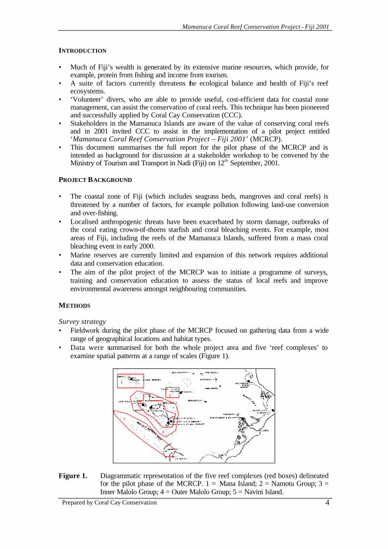
INTRODUCTION • Much of Fiji’s wealth is generated by its extensive marine resources, which provide, for
example, protein from fishing and income from tourism. • A suite of factors currently threatens the ecological balance and health of Fiji’s reef
ecosystems. • ‘Volunteer’ divers, who are able to provide useful, cost-efficient data for coastal zone
management, can assist the conservation of coral reefs. This technique has been pioneered and successfully applied by Coral Cay Conservation (CCC).
• Stakeholders in the Mamanuca Islands are aware of the value of conserving coral reefs and in 2001 invited CCC to assist in the implementation of a pilot project entitled ‘Mamanuca Coral Reef Conservation Project – Fiji 2001’ (MCRCP).
• This document summarises the full report for the pilot phase of the MCRCP and is intended as background for discussion at a stakeholder workshop to be convened by the Ministry of Tourism and Transport in Nadi (Fiji) on 12th September, 2001.
PROJECT BACKGROUND • The coastal zone of Fiji (which includes seagrass beds, mangroves and coral reefs) is
threatened by a number of factors, for example pollution following land-use conversion and over-fishing.
• Localised anthropogenic threats have been exacerbated by storm damage, outbreaks of the coral eating crown-of-thorns starfish and coral bleaching events. For example, most areas of Fiji, including the reefs of the Mamanuca Islands, suffered from a mass coral bleaching event in early 2000.
• Marine reserves are currently limited and expansion of this network requires additional data and conservation education.
• The aim of the pilot project of the MCRCP was to initiate a programme of surveys, training and conservation education to assess the status of local reefs and improve environmental awareness amongst neighbouring communities.
METHODS Survey strategy • Fieldwork during the pilot phase of the MCRCP focused on gathering data from a wide
range of geographical locations and habitat types. • Data were summarised for both the whole project area and five ‘reef complexes’ to
examine spatial patterns at a range of scales (Figure 1).
Figure 1. Diagrammatic representation of the five reef complexes (red boxes) delineated
for the pilot phase of the MCRCP. 1 = Mana Island; 2 = Namotu Group; 3 = Inner Malolo Group; 4 = Outer Malolo Group; 5 = Navini Island.
1
2
4
5
3
Mamanuca Coral Reef Conservation Project - Fiji 2001
Prepared by Coral Cay Conservation
5
• The survey techniques used were: baseline transects for habitat mapping; Reef Check surveys to assess reef health; and size-frequency surveys to assess the population status of five target coral taxa. Data were collected at similar sites to facilitate comparisons between data sets.
Volunteer training • During the MCRCP, CCC volunteers underwent an intensive twelve-day training
programme to provide them with the skills necessary to accurately and consistently collect the requisite data.
Baseline transect technique • Habitat mapping was achieved using a standard baseline survey technique developed by
CCC that uses a series of transects perpendicular to the reef. • Transects, or parts of transects, were surveyed by a team of four trained divers, each
assessing either the physical characteristics of the site or the abundance of a specific group of organisms (e.g. fish or hard corals).
• Certain oceanographic data and observations on obvious anthropogenic impacts and activities were also recorded at depth by the divers and from the surface support vessel.
Habitat mapping • In order to produce a preliminary habitat map for the project area, a ‘Landsat 7’ satellite
image was purchased. • This image was geometrically corrected and the land, deepwater and clouds were masked. • Following an ‘unsupervised classification’ of the image, the use of field data from the
baseline transects facilitated the assignment of a benthic class to every point on the map. Reef Check • The widely used ‘Reef Check’ protocol was used to assess reef health. The protocol
utilises a 100 m transect, split into four 20 m sections, along a given depth contour. • Five types of data were recorded: a site description sheet; abundance of commercially
important fish; abundance of target invertebrate taxa; obvious anthropogenic impacts and the percentage cover of substratum types and components of the benthic community.
Coral size-frequencies • At each site, coral size-frequency surveys combined the sizing of colonies of five target
taxa with an assessment of the percentage of living tissue in a series of 49 m2 quadrats along a notional 100 m transect.
• Target taxa were ‘massive’ life forms of the genus Porites, Pocillopora verrucosa / meandrina / elegans, Ctenactis echinata, Diploastrea heliopora and Seriatopora hystrix.
Observations of megafauna • Observations of ‘megafauna’ were recorded throughout the pilot phase of the MCRCP. Data analysis • Data generated by each survey technique were analysed via a suite of univariate and
multivariate statistics either for the whole project area or for each reef complex. • In addition, Reef Check data were used to plot a ‘ternary diagram’ of coral morphology in
order to assign conservation values to each site. Community work • As part of the pilot phase of the MCRCP, a marine ecology workshop designed for the
diving professional working in the Mamanuca Islands was conducted.
Mamanuca Coral Reef Conservation Project - Fiji 2001
Prepared by Coral Cay Conservation
6
• Students from the International Secondary School, Suva, visited the pilot phase as part of their course on analysing marine ecosystems.
Meetings during the course of the pilot phase of the MCRCP • Daniel Afzal participated in a workshop to discuss the ‘WWF Community Based Marine
Protected Area Management Plan Development for Waisomo and Narikoso, Ono District, Kandavu’ and a meeting of the Global Coral Reef Monioring Network for the Southwest Pacific ‘Node’.
• Project staff attended several other meetings to introduce the project to local stakeholders, including Ratu Sevanaia Vatunitu Nabola, Luilui Ni Yavusa (Chief of Solevu village).
RESULTS Volunteer training • The results of the various tests and validation exercises that concluded the science
training weeks showed that the volunteers achieved a high standard of identification and surveying proficiency.
Baseline transects • A total of 74 dives were completed (37 full baseline transects) in the project area. • Mean surface water temperature was 26.4oC, mean surface water salinity was 34.6‰ and
winds were predominantly from the south-east. • Water visibility (a measure of sedimentation) varied significantly between the five reef
complexes: turbidity increased from the Namotu Group (lowest sediment load) to the Inner Malolo Group and Navini Island (joint highest).
• Algae was the most abundant surface impacts but litter was also relatively common. • Litter, coral damage and bleaching (only occasional colonies) were common underwater
impacts. There was some variation between reef complexes e.g. sedimentation was more common in the Inner Malolo Group complex.
• The highest density of boats was in the Namotu Group and the Inner Malolo Group. • Aesthetic and biological ratings of dive quality were typically between average to good,
with the exception of the Inner Malolo Group complex where ratings were poor to average. The highest ratings were assigned at Mana Island and in the Namotu Group.
• Analysis of the biological survey data discriminated seven major benthic classes: Sand with sparse algae and seagrass; Sand and algae; Sand with small coral patches; Bedrock, dead coral and sparse corals; Mixed substratum, green algae and coral; Sand with large coral patches; Bedrock and mixed corals.
• Damselfish were the most common fish in the project area. • There was evidence of different fish communities in each benthic class with generally
lower abundances in sand classes compared with coral classes. • After restricting analysis to the most coral-rich benthic class there was evidence of
variations of target fish species between reef complexes e.g. unicornfish, triggerfish and flagtail groupers were most abundant in the Namotu Group.
• Across all survey sites there was a correlation between coral and fish species richness. • There was evidence of different invertebrate communities in each benthic class with
generally lower abundances in sand classes compared with coral classes. • After restricting analysis to the most coral-rich benthic class there was evidence of
variations of target invertebrate species between reef complexes e.g. Diadema urchins were most abundant in the Inner Malolo group.
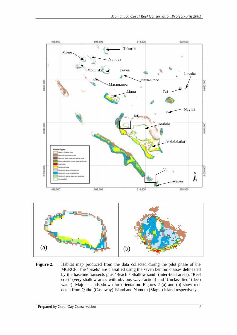
Habitat mapping • Figure 2 shows the habitat map produced from classification of the satellite image.
Mamanuca Coral Reef Conservation Project - Fiji 2001
Prepared by Coral Cay Conservation
7
Figure 2. Habitat map produced from the data collected during the pilot phase of the
MCRCP. The ‘pixels’ are classified using the seven benthic classes delineated by the baseline transects plus ‘Beach / Shallow sand’ (inter-tidal areas), ‘Reef crest’ (very shallow areas with obvious wave action) and ‘Unclassified’ (deep water). Major islands shown for orientation. Figures 2 (a) and (b) show reef detail from Qalito (Castaway) Island and Namotu (Magic) Island respectively.
(a) (b)
(a)
(b)
Tokoriki
Matamanoa
Tavua Monuriki
Mana Tai
Monu
Lovuka
Navini
Malolo
Malololailai
Tavarua
Yanuya
Nautanirono
Mamanuca Coral Reef Conservation Project - Fiji 2001
Prepared by Coral Cay Conservation
8
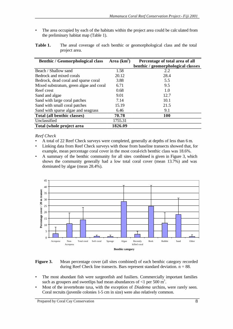
• The area occupied by each of the habitats within the project area could be calculated from the preliminary habitat map (Table 1).
Table 1. The areal coverage of each benthic or geomorphological class and the total
project area.
Benthic / Geomorphological class Area (km2) Percentage of total area of all benthic / geomorphological classes
Beach / Shallow sand 1.58 2.2 Bedrock and mixed corals 20.12 28.4 Bedrock, dead coral and sparse coral 3.88 5.5 Mixed substratum, green algae and coral 6.71 9.5 Reef crest 0.68 1.0 Sand and algae 9.01 12.7 Sand with large coral patches 7.14 10.1 Sand with small coral patches 15.19 21.5 Sand with sparse algae and seagrass 6.46 9.1 Total (all benthic classes) 70.78 100 Unclassified 1755.31 Total (whole project area 1826.09 Reef Check • A total of 22 Reef Check surveys were completed, generally at depths of less than 6 m. • Linking data from Reef Check surveys with those from baseline transects showed that, for
example, mean percentage coral cover in the most coral-rich benthic class was 18.6%. • A summary of the benthic community for all sites combined is given in Figure 3, which
shows the community generally had a low total coral cover (mean 13.7%) and was dominated by algae (mean 28.4%).
0
5
10
15
20
25
30
35
40
45
Acropora Non-Acropora
Total coral Soft coral Sponge Algae Recentlykilled coral
Rock Rubble Sand Other
Benthic category
Per
cent
age
cove
r /
20 m
tra
nsec
t
Figure 3. Mean percentage cover (all sites combined) of each benthic category recorded
during Reef Check line transects. Bars represent standard deviation. n = 88. • The most abundant fish were surgeonfish and fusiliers. Commercially important families
such as groupers and sweetlips had mean abundances of <1 per 500 m3. • Most of the invertebrate taxa, with the exception of Diadema urchins, were rarely seen.
Coral recruits (juvenile colonies 1-5 cm in size) were also relatively common.
Mamanuca Coral Reef Conservation Project - Fiji 2001
Prepared by Coral Cay Conservation
9
• Of the 45 parameters measured during Reef Check surveys, only eight (17.8%) varied significantly between reef complexes.
• Regression analysis between each fish and invertebrate taxa and coral cover highlighted significant correlations for snappers, groupers, parrotfish and surgeonfish.
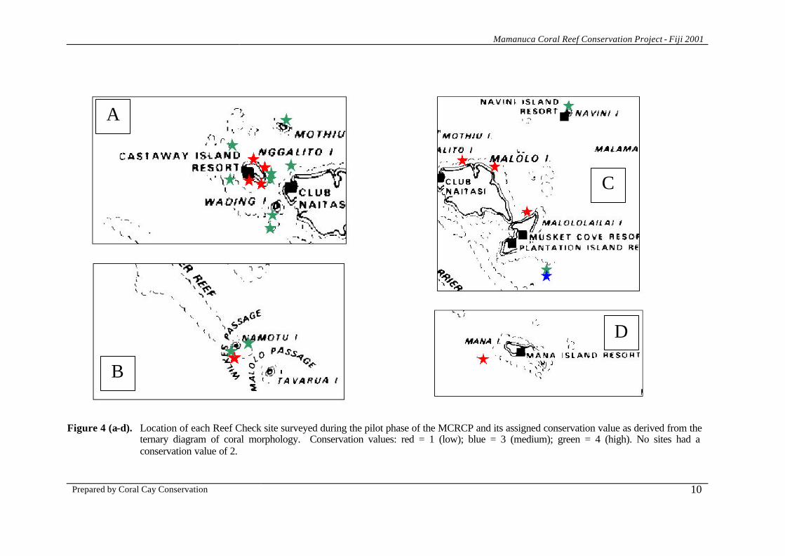
• The ‘ternary diagram’ plotting the conservation value of each Reef Check site, showed that 12 of the sites (54.5%) had conservation values of four, nine sites (40.9%) had conservation values of one and a single site had a conservation value of three. The locations of the sites with their assigned conservation values are shown on Figure 4 (overleaf).
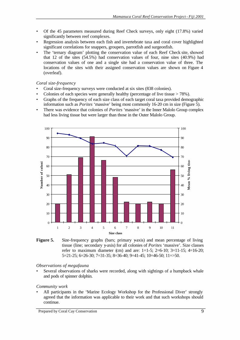
Coral size-frequency • Coral size-frequency surveys were conducted at six sites (838 colonies). • Colonies of each species were generally healthy (percentage of live tissue > 78%). • Graphs of the frequency of each size class of each target coral taxa provided demographic
information such as Porites ‘massive’ being most commonly 16-20 cm in size (Figure 5). • There was evidence that colonies of Porites ‘massive’ in the Inner Malolo Group complex
had less living tissue but were larger than those in the Outer Malolo Group.
0
10
20
30
40
50
60
70
80
90
100
1 2 3 4 5 6 7 8 9 10 11
Size class
Nu
mb
er o
f co
lon
ies
0
10
20
30
40
50
60
70
80
90
100
Mea
n %
liv
ing
tis
sue
Figure 5. Size-frequency graphs (bars; primary y-axis) and mean percentage of living
tissue (line; secondary y-axis) for all colonies of Porites ‘massive’. Size classes refer to maximum diameter (cm) and are: 1=1-5; 2=6-10; 3=11-15; 4=16-20; 5=21-25; 6=26-30; 7=31-35; 8=36-40; 9=41-45; 10=46-50; 11=>50.
Observations of megafauna • Several observations of sharks were recorded, along with sightings of a humpback whale
and pods of spinner dolphin. Community work • All participants in the ‘Marine Ecology Workshop for the Professional Diver’ strongly
agreed that the information was applicable to their work and that such workshops should continue.
Mamanuca Coral Reef Conservation Project - Fiji 2001
Prepared by Coral Cay Conservation
10
Figure 4 (a-d). Location of each Reef Check site surveyed during the pilot phase of the MCRCP and its assigned conservation value as derived from the
ternary diagram of coral morphology. Conservation values: red = 1 (low); blue = 3 (medium); green = 4 (high). No sites had a conservation value of 2.
A
B
D
C
Mamanuca Coral Reef Conservation Project - Fiji 2001
Prepared by Coral Cay Conservation
11
DISCUSSION Training • The training programme used by CCC for the pilot phase of the MCRCP proved to be
appropriate for volunteer-based survey work in Fiji. Baseline data • Climate data showed that the environmental conditions were seasonally typical during the
fieldwork. • Modelling water movement patterns more accurately than was possible in this study will
be vital to assess entrainment of fish and coral larvae between ‘source’ and ‘sink’ areas. • There was evidence of a number of anthropogenic impacts affecting the area. For
example, there was relatively high sedimentation in the Inner Malolo Group because of the development of a series of major resorts and felling natural forests. Generic coral damage, possibly from diver or anchor damage, was common in the Mana Island, Namotu Group and Inner Malolo Group reef complexes.
• Overall, the indication is that all the reefs of the project area have been subjected to some degradation but the reefs of the Inner Malolo Group seem most heavily impacted and this was reflected in the aesthetic and biological ratings assigned by the survey teams.
• The seven benthic classes derived from the biological data are likely to cover all the major classes present on the reefs surveyed.
• The benthic classes were all relatively coral poor and this is evidence of the major effect that the 2000 coral bleaching had on the Mamanuca Islands. Coral mortality seems to have led to increased algal growth.
• There was a recurring pattern of a greater abundance and diversity of fish in coral rich classes because of the increased spatial complexity of these habitats.
• The commercially important flagtail grouper was most abundant in the Namotu Group complex, possibly because of a lower fishing pressure, the presence of a privately owned marine reserve and / or the high abundance of prey species.
• Invertebrates were generally uncommon but the particularly low abundance of commercially important invertebrates was noticeable (e.g. no tritons were seen).
• The low abundances of the corallivorous Drupella snails and crown-of-thorns starfish indicated that the threat from these species is currently minimal.
Habitat mapping • Further data are required to improve the classification of the satellite image and more
sophisticated processing will result in a more accurate map. However, the current version of the map is appropriate for the preliminary assessment of, for example, the locations of coral rich areas.
• The estimates of areal extents of each benthic class are instructive e.g. there is only approximately 70 km2 of reefal habitats. Similarly, the area supporting the most coral-rich benthic class is only approximately 20 km2, showing the damage caused by bleaching and local anthropogenic impacts and the urgent need to conserve remaining coral rich areas.
Reef Check • Reef Check data showed that benthic communities within the project area have been
significantly impacted, much of which can be attributed to the 2000 coral bleaching event e.g. most of the sites are currently in ‘poor’ condition using the coral cover criteria of the ASEAN-Australia Living Coastal Resources project.
• The fish and invertebrate data also indicated significant human impacts, especially over-fishing e.g. some valuable species, such as the bumphead parrotfish, were absent.
• The number of coral ‘recruits’ (colonies sized from 1-5 cm) provided some evidence of reef recovery.
Mamanuca Coral Reef Conservation Project - Fiji 2001
Prepared by Coral Cay Conservation
12
• Reef Check data provided further evidence of fish and invertebrate abundances increasing with increasing coral cover e.g. all other things being equal, the abundance of snappers increases by 1.4 fish per 500 m3 with an increase of coral cover of 10%.
• Analysis of ‘conservation values’ showed that, despite the impacts to the area, a large proportion of the sites had a high conservation value (>50%) but further data are needed and these results must be combined with other information such as live coral cover.
Coral size-frequencies • Size-frequency graphs showed that, despite recent mortality, population structures were
typical. These data can be used, for example, to assess the impacts of the aquarium trade by comparing the demographics of the natural and harvested colonies.
• Statistics indicate that colonies are healthy and are likely to be able to reproduce sexually, providing larvae for regenerating areas damaged by bleaching.
• The lower percentage of living tissue on ‘massive’ Porites in the Inner Malolo Group complex may be linked to factors such as sedimentation.
Observations of megafauna • A relatively large number of megafaunal species were seen during the pilot phase of the
MCRCP, which is encouraging for the tourist industry. Community work • All coastal zone management initiatives must take into account the needs and concerns of
local communities. • Although the community work completed during the pilot phase of the MCRCP was
inevitably limited, it is clear that such work can be successful and represented a first step that will be subject to evaluation.
CONCLUSIONS • The pilot project of the MCRCP has shown that a suite of detrimental anthropogenic
influences is present in the Mamanuca Islands. Perhaps the most obvious of these impacts was the mass coral bleaching event which occurred in early 2000.
• The link between coral cover and the abundance of commercially important fish was clearly demonstrated by data collected during the pilot phase.
• Although the coral bleaching event was severe, its impacts appear to be acting synergistically with more localised impacts including: sedimentation; over-fishing; increased nutrient loads; collection of aquarium species; mechanical damage (from dredging, anchors and diving); coral diseases; crown-of-thorns starfish; and litter.
• The results of this work also show, for example, that some parameters indicate lower reef health and greater threats in the ‘Inner Malolo Group’ reef complex.
• The support by many stakeholders for mitigating measures in the Mamanuca Islands represents a clear desire to address the threats to reef health and work towards sustainable use. Such a goal could be addressed by both reducing the threats to reef health (e.g. improving water quality) and establishing a chain of marine reserves.
• Further research is required to ensure new reserves are placed in optimal positions. • Theoretical models indicate that 20% of the reefs of an area should be ‘no-take’ in order
to maximise the chances of sustaining the fisheries and given that the reefs delineated on the habitat map cover approximately 70 km2, the eventual aim should be to protect 14 km2 of shallow (<30 m) benthic habitat within the Mamanuca Islands from fishing.
• ‘Conservation values’ used for each Reef Check site in this study represent a good protocol for highlighting priority areas within the project area.
Mamanuca Coral Reef Conservation Project - Fiji 2001
Prepared by Coral Cay Conservation
13
RECOMMENDATIONS Given the nascent status of the MCRCP, the following recommendations are intended as guidance to stimulate discussion rather than as a blueprint for coastal zone management in the Mamanuca Islands. • Aim to establish one or more multiple use marine protected areas in the Mamanuca
Islands with regulations limiting deleterious effects (i.e. integrated coastal zone management). These protected areas should aim to eventually contain approximately 14 km2 of ‘no-take’ zones.
• No-take zones in the Mamanuca Islands should integrate a range of factors including the preference of many fish species for coral rich habitats, protecting a range of habitat types, including mangroves and seagrass beds, and ‘conservation values’ provided by ternary diagrams and other techniques.
• Consider the establishment of a ‘Mamanuca Coastal Zone Management Group’, including representatives from local communities, the tourist industry, Fijian NGOs, government agencies, the University of the South Pacific and other stakeholders.
• Establish conservation education programmes, including the rationale for marine protected areas, for all stakeholders at the local and national level but particularly targeted at local communities and the tourist industry.
• Establish an integrated programme to monitor reef health in the Mamanuca Islands. Reef Check has been shown to provide a good basis for reef health monitoring and non-professional divers can collect these data accurately and rapidly. The sites surveyed during the pilot phase of the MCRCP could form the basis of this monitoring programme and could be re-surveyed by local people (such as resort staff) following appropriate training programmes. All data collected by this monitoring programme should feed into both the Southwest Pacific nodes for Reef Check and GCRMN.
• Establish a programme to monitor fisherfolk and their activities in the Mamanuca Islands. Such a programme should focus on species caught, weights landed, sites used and ideally catch per unit effort. Such a programme should incorporate both artisanal and commercial operations.
• Use the data already recorded by resorts on the number of dives undertaken at sites in the Mamanuca Islands. These data could be used to help interpret monitoring programmes and assist any future ‘carrying capacity’ calculations.
• Establish a standard environmental awareness briefing for all divers that can be used by dive resorts in the Mamanuca Islands. Such a briefing could be developed using the PADI AWARE programme. Mechanical damage to dive sites could also be reduced by extending and improving the system of permanent mooring buoys.
• Establish an integrated GIS and associated meta-database for the Mamanuca Islands, including data from the pilot phase of the MCRCP. Such a system could also be combined with any future national database and information held by the Southwest Pacific node of GCRMN.
• Examine the potential of using data collected by the pilot phase of the MCRCP as the basis of national habitat classification scheme and subsequent national habitat map.
Many of the recommendations listed here could be achieved by extending the pilot phase of the MCRCP to a long-term commitment by CCC, in conjunction with Fijian partners, to the Mamanuca Islands.