MALDON DISTRICT LOCAL HIGHWAYS PANEL MEETING – 1 … Reports 1 April 2016.pdf · Fambridge Road,...
80
Page 1 / 1 MALDON DISTRICT LOCAL HIGHWAYS PANEL MEETING – 1 APRIL 2016 Council Chamber, Princes Road, Maldon – at 9.00AM Membership: Essex County Council – Councillors R L Bass (Chairman), R G Boyce MBE and Mrs P A Channer Maldon District Council – Councillors Mrs B D Harker, M W Helm, J V Keyes, Miss M R Lewis, R Pratt (Vice-Chairman), Mrs M E Thompson AGENDA 1. Apologies for absence. 2. Minutes of last meeting held on 15 January 2016 (copy enclosed). 3. Matters Arising from Minutes of the Previous Meeting 4. Approved Works Programme and APPENDIX 1 – Additional Information (copy enclosed) 5. Potential Schemes List 2015/16 and APPENDIX 2 – Additional Information (copy enclosed) 6. Highway Rangers Work Summary – February 2016 (copy enclosed). 7. Any other Urgent Business. (i) Items requested by Panel Members. Enquiries to: Stuart Jennings, Committee Services Manager/Highways Liaison Officer - tel 01621 875745 or email [email protected] or Helen Overton – tel 01621 875706 or email [email protected] Jon Simmons - Essex County Council Customer Liaison Team – tel 0845 603 7631 or email [email protected].
Transcript of MALDON DISTRICT LOCAL HIGHWAYS PANEL MEETING – 1 … Reports 1 April 2016.pdf · Fambridge Road,...

Page 1 / 1
MALDON DISTRICT LOCAL HIGHWAYS PANEL MEETING – 1 APRIL 2016 Council Chamber, Princes Road, Maldon – at 9.00AM Membership: Essex County Council – Councillors R L Bass (Chairman), R G Boyce MBE and Mrs P A Channer Maldon District Council – Councillors Mrs B D Harker, M W Helm, J V Keyes, Miss M R Lewis, R Pratt (Vice-Chairman), Mrs M E Thompson AGENDA 1. Apologies for absence.
2. Minutes of last meeting held on 15 January 2016 (copy enclosed).
3. Matters Arising from Minutes of the Previous Meeting
4. Approved Works Programme and APPENDIX 1 – Additional Information (copy enclosed) 5. Potential Schemes List 2015/16 and APPENDIX 2 – Additional Information (copy enclosed)
6. Highway Rangers Work Summary – February 2016 (copy enclosed). 7. Any other Urgent Business.
(i) Items requested by Panel Members.
Enquiries to: Stuart Jennings, Committee Services Manager/Highways Liaison Officer - tel 01621 875745 or email [email protected] or Helen Overton – tel 01621 875706 or email [email protected] Jon Simmons - Essex County Council Customer Liaison Team – tel 0845 603 7631 or email [email protected].
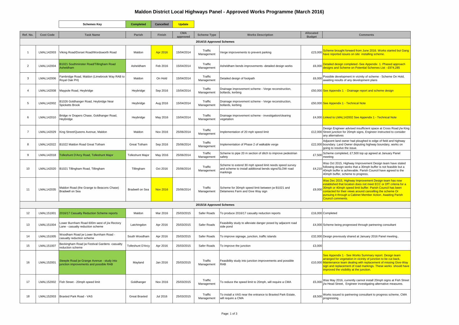
Maldon District Local Highways Panel - Approved Works Programme (March 2016)
Schemes Key Completed Cancelled Update
Ref. No. Cost Code Task Name Parish FinishCMA
approvedScheme Type Works Description
Allocated
BudgetComments
1 LMAL142003 Viking Road/Dorset Road/Wordsworth Road Maldon Apr 2016 15/04/2014Traffic
ManagementVerge improvements to prevent parking £23,000
Scheme brought forward from June 2016. Works started but Gang
have reported issues on site installing scheme.
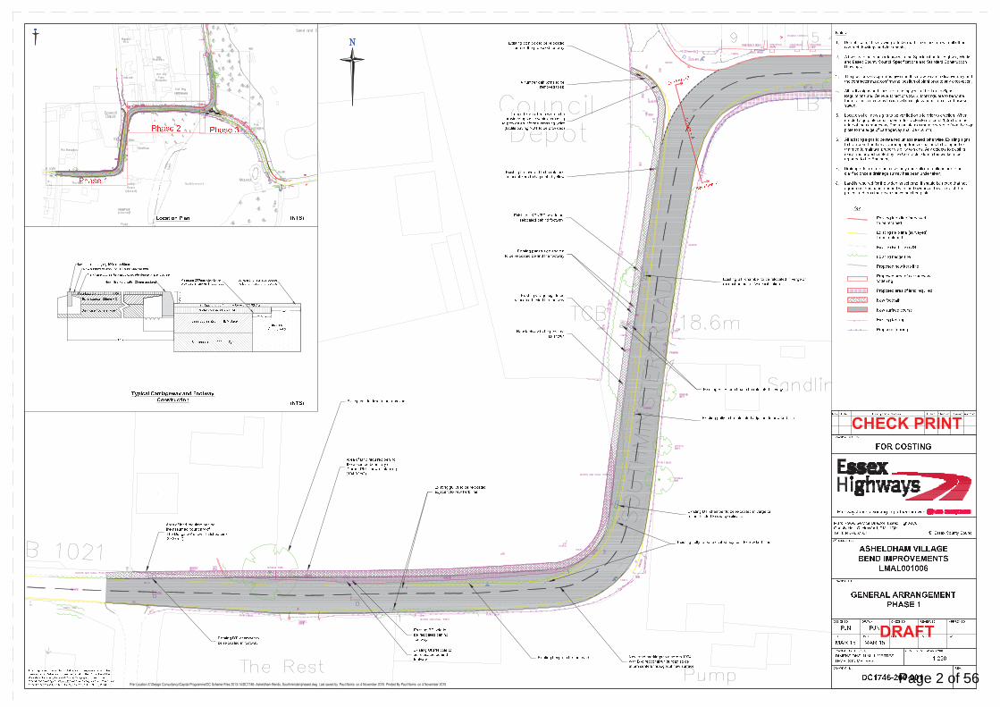
2 LMAL142004B1021 Southminster Road/Tillingham Road
AsheldhamAsheldham Feb 2016 15/04/2014
Traffic
ManagementAsheldham bends improvements -detailed design works £6,000
Detailed design completed -See Appendix 1. Phased approach
designs and Scheme on Potential Schemes List - £974,285
3 LMAL142006Fambridge Road, Maldon (Limebrook Way RAB to
Royal Oak PH)Maldon On Hold 15/04/2014
Traffic
ManagementDetailed design of footpath £6,000
Possible development in vicinity of scheme - Scheme On Hold,
awaiting results of any development plans
4 LMAL142008 Maypole Road, Heybridge Heybridge Sep 2016 15/04/2014Traffic
Management
Drainage improvement scheme - Verge reconstruction,
bollards, kerbing £50,000 See Appendix 1 - Drainage report and scheme design
5 LMAL142002B1026 Goldhanger Road, Heybridge Near
Spicketts BrookHeybridge Aug 2016 15/04/2014
Traffic
Management
Drainage improvement scheme - Verge reconstruction,
bollards, kerbing £50,000 See Appendix 1 - Technical Note
6 LMAL142010Bridge nr Drapers Chase, Goldhanger Road,
HeybridgeHeybridge May 2016 15/04/2014
Traffic
Management
Drainage improvement scheme - investigation/clearing
vegetation£4,000 Linked to LMAL142002 See Appendix 1 - Technical Note
7 LMAL142029 King Street/Queens Avenue, Maldon Maldon Nov 2016 25/06/2014Traffic
ManagementImplementation of 20 mph speed limit £12,000
Design Engineer advised insufficient space at Cross Road j/w King
Street junction for 20mph signs, Engineer instructed to consider
any alternatives
8 LMAL142022 B1022 Maldon Road Great Totham Great Totham Sep 2016 25/06/2014Traffic
ManagementImplementation of Phase 2 of walkable verge £22,000
Adjacent land owner had ploughed to edge of field and highway
boundary. Land Owner disputing highway boundary, works on
going to resolve the issue.
9 LMAL142018 Tolleshunt D'Arcy Road, Tolleshunt Major Tolleshunt Major May 2016 25/06/2014Traffic
Management
Scheme to pipe 20 m section of ditch to improve pedestrian
safety£7,500
Scheme completed, £7,500 top up agreed at January Panel
meeting
10 LMAL142020 B1021 Tillingham Road, Tillingham Tillingham Oct 2016 25/06/2014Traffic
Management
Scheme to extend 30 mph speed limit needs speed survey
and scheme to install additional bends signs/SLOW road
markings
£4,210
Was Oct 2015, Highway Improvement Design team have stated
following design works that a 30mph buffer is not feasible but a
40mph buffer is achievable. Parish Council have agreed to the
40mph buffer, scheme to progress.
11 LMAL142035Maldon Road (the Grange to Beacons Chase)
Bradwell on SeaBradwell on Sea Nov 2016 25/06/2014
Traffic
Management
Scheme for 30mph speed limit between jw B1021 and
Delameres Farm and Give Way sign£9,000
Was Dec 2015, Highway Improvement Design team has now
established that location does not meet ECC or DfT criteria for a
30mph or 40mph speed limit buffer. Parish Council has been
contacted for their views around cancelling the scheme Or
pursuing it through a Cabinet Member Action. Awaiting Parish
Council comments.
12 LMAL151001 2016/17 Casualty Reduction Scheme reports Maldon Mar 2016 25/03/2015 Safer Roads To produce 2016/17 casualty reduction reports £16,000 Completed
13 LMAL151004Lower Burnham Road 600m west of j/w Rectory
Lane - casualty reduction schemeLatchingdon Apr 2016 25/03/2015 Safer Roads
Feasibility study to alleviate danger posed by adjacent road
side pond£4,000 Scheme being progressed through partnering consultant
14 LMAL151005Woodham Road jw Lower Burnham Road -
casualty reduction schemeSouth Woodham Apr 2016 25/03/2015 Safer Roads To improve signage, junction, traffic islands £32,000 Design previously shared at January 2016 Panel meeting..
15 LMAL151007Beckingham Road jw Festival Gardens -casualty
reduction schemeTolleshunt D'Arcy Apr 2016 25/03/2015 Safer Roads To improve the junction £3,000
16 LMAL152001Steeple Road jw Grange Avenue - study into
junction improvements and possible RABMayland Jan 2016 25/03/2015
Traffic
Management
Feasibility study into junction improvements and possible
RAB£10,000
See Appendix 1 - See Works Summary report. Design team
arranged for vegetation in vicinity of junction to be cut back,
Maintenance team dealing with replacement of missing Give-Way
sign and replacement of road markings. These works should have
improved the visibility at the junction.
17 LMAL152002 Fish Street - 20mph speed limit Goldhanger Nov 2016 25/03/2015Traffic
ManagementTo reduce the speed limit to 20mph, will require a CMA £5,000
Was May 2016, currently cannot install 20mph signs at Fish Street
j/w Head Street, Engineer investigating alternative measures.
18 LMAL152003 Braxted Park Road - VAS Great Braxted Jul 2016 25/03/2015Traffic
Management
To install a VAS near the entrance to Braxted Park Estate,
will require a CMA£8,500
Works issued to partnering consultant to progress scheme, CMA
progressing.
2014/15 Approved Schemes
2015/16 Approved Schemes
Page: 1 of 3

Maldon District Local Highways Panel - Approved Works Programme (March 2016)
Schemes Key Completed Cancelled Update
Ref. No. Cost Code Task Name Parish FinishCMA
approvedScheme Type Works Description
Allocated
BudgetComments
19 LMAL152004 Walden House Road - Creation of lay-by Great Totham Jul 2016 25/03/2015Traffic
ManagementWorks to formalise parking on verge with lay-by £25,000
UKPN diversion works complete, Exception report due to width of
lay-by signed off. Scheme to progress
20 LMAL152005 Basin Road - Pedestrians in Road signage Heybridge Jan 2016 25/03/2015Traffic
Management
Scheme to remove existing column/bend warning sign and
replace with new column/pedestrian in Road sign with
external illumination
£8,000 Completed
21 LMAL152006 Burnham Road - VAS Latchingdon Jun 2016 25/03/2015Traffic
ManagementTo install a VAS on Burnham Road, will require a CMA £8,500 Scheme being progressed through partnering consultant.
22 LMAL152009Burnham Road jw Maldon Road - Improvements
to advanced give-way signageMundon Apr 2016 25/03/2015
Traffic
ManagementImprovements to advanced give-way signage at A1 Corner £3,000 Scheme being progressed through partnering consultant.
23 LMAL152010Fambridge Road (Lower Burnham Road to
Rectory Road) - Study into provision of footwayNorth Fambridge Apr 2016 25/03/2015
Traffic
Management
Feasibility Study to consider provision of new
footway/walkable verge£5,000 Scheme being progressed through partnering consultant.
24 LMAL152011 The Avenue - Study into widening of footway North Fambridge Apr 2016 25/03/2015Traffic
ManagementFeasibility Study into widening of footway £3,000
25 LMAL152012High Street/Station Road/North Street/Burnham
Road - 20mph speed limitSouthminster Oct 2016 25/03/2015
Traffic
ManagementTo reduce speed limit to 20mph, will require a CMA £10,000
Scheme now progressing following additional automatic traffic
counts, though Station Road does not meet criteria for a 20mph .
26 LMAL152013 Main Road - improvements to traffic calming St Lawrence Apr 2016 25/03/2015Traffic
ManagementInstallation of solar lighting at existing priority working £10,500
Clarification being sought from Parish Council as the electricity
supply here appears to be a Parish one.
27 LMAL152014Woodham Road j/w Martins Lane - Study into
drainage improvementsStow Maries Jun 2016 25/03/2015
Traffic
ManagementFeasibility study into drainage improvements £5,000 Drainage Engineer now progressing scheme.
28 LMAL152015Church Lane (Nr Four Elms/Glebelands - Study
into carriageway improvementsStow Maries Feb 2016 25/03/2015
Traffic
Management
Feasibility study into carriageway improvements to address
drainage issues as properties at lower level to carriageway £3,000
Completed See Appendix 1 for Feasibility Study, kerbing scheme
option now added to Potential Scheme List.
29 LMAL152017 Church Street - dropped kerbs Tollesbury Jul 2016 25/03/2015Traffic
ManagementDropped kerbs to improve access to bus stop £6,500
30 LMAL152018Parish Rooms Church Street - Study into improved
access/surfacingTollesbury Apr 2016 25/03/2015
Traffic
ManagementFeasibility Study into improved access/surfacing £3,000
31 LMAL152020Beckingham Street/Tolleshunt D'Arcy Road -
Study into junction improvementsTolleshunt Major Feb 2016 25/03/2015
Traffic
ManagementFeasibility Study into junction improvements £3,000
See Appendix 1 - feasibility study recommends removal of bennett
junction an installation of standard T-junction. Now a scheme on
Potential Scheme List.
32 LMAL152022Maldon Road nr Does Corner - Study into
drainage improvementsUlting May 2016 25/03/2015
Traffic
ManagementFeasibility Study into drainage improvements £3,000 Drainage Engineer now progressing scheme.
33 LMAL152023Crouchman's Farm Road - Study into drainage
improvementsUlting Apr 2016 25/03/2015
Traffic
ManagementFeasibility Study into drainage improvements £3,000 Drainage Engineer now progressing scheme.
34 LMAL152025Witham Road/The Street/Maypole Road/Kelvedon
Road/Beacon Hill - SID poles and SIDWickham Bishops Aug 2016 25/03/2015
Traffic
ManagementTo provide SID poles and SID, will require a CMA £17,500 CMA progressing
35 LMAL152026 Mill Road - Bus Priority Improvements Maldon Cancelled 25/03/2015Traffic
Management
To improve the bus priority measures to prevent vehicles
driving across adjacent forecourt to avoid restriction£16,500
MDC granted planning permission for redevelopment of former
garage site granted on 22/10/15 under FUL/MAL/15/00760.
Proposed development would build out over forecourt, scheme not
required..
2015/16 Approved Schemes (Continued)
Page: 2 of 3
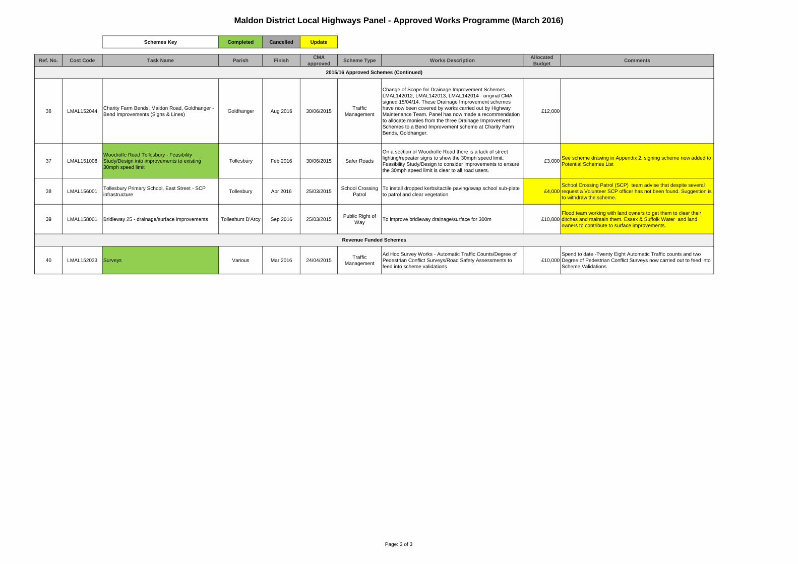
Maldon District Local Highways Panel - Approved Works Programme (March 2016)
Schemes Key Completed Cancelled Update
Ref. No. Cost Code Task Name Parish FinishCMA
approvedScheme Type Works Description
Allocated
BudgetComments
36 LMAL152044Charity Farm Bends, Maldon Road, Goldhanger -
Bend Improvements (Signs & Lines) Goldhanger Aug 2016 30/06/2015
Traffic
Management
Change of Scope for Drainage Improvement Schemes -
LMAL142012, LMAL142013, LMAL142014 - original CMA
signed 15/04/14. These Drainage Improvement schemes
have now been covered by works carried out by Highway
Maintenance Team. Panel has now made a recommendation
to allocate monies from the three Drainage Improvement
Schemes to a Bend Improvement scheme at Charity Farm
Bends, Goldhanger.
£12,000
37 LMAL151008
Woodrolfe Road Tollesbury - Feasibility
Study/Design into improvements to existing
30mph speed limit
Tollesbury Feb 2016 30/06/2015 Safer Roads
On a section of Woodrolfe Road there is a lack of street
lighting/repeater signs to show the 30mph speed limit.
Feasibility Study/Design to consider improvements to ensure
the 30mph speed limit is clear to all road users.
£3,000See scheme drawing in Appendix 2, signing scheme now added to
Potential Schemes List
38 LMAL156001Tollesbury Primary School, East Street - SCP
infrastructureTollesbury Apr 2016 25/03/2015
School Crossing
Patrol
To install dropped kerbs/tactile paving/swap school sub-plate
to patrol and clear vegetation£4,000
School Crossing Patrol (SCP) team advise that despite several
request a Volunteer SCP officer has not been found. Suggestion is
to withdraw the scheme.
39 LMAL158001 Bridleway 25 - drainage/surface improvements Tolleshunt D'Arcy Sep 2016 25/03/2015Public Right of
WayTo improve bridleway drainage/surface for 300m £10,800
Flood team working with land owners to get them to clear their
ditches and maintain them. Essex & Suffolk Water and land
owners to contribute to surface improvements.
40 LMAL152033 Surveys Various Mar 2016 24/04/2015Traffic
Management
Ad Hoc Survey Works - Automatic Traffic Counts/Degree of
Pedestrian Conflict Surveys/Road Safety Assessments to
feed into scheme validations
£10,000
Spend to date -Twenty Eight Automatic Traffic counts and two
Degree of Pedestrian Conflict Surveys now carried out to feed into
Scheme Validations
Revenue Funded Schemes
2015/16 Approved Schemes (Continued)
Page: 3 of 3
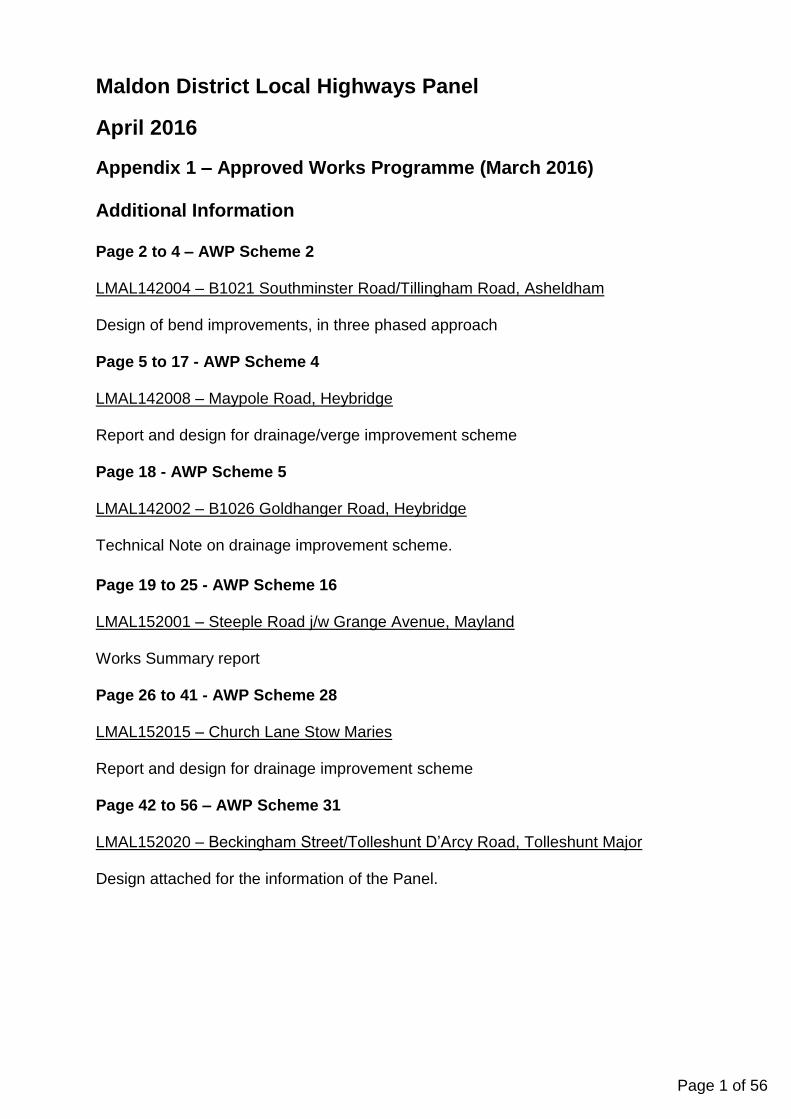
Maldon District Local Highways Panel
April 2016
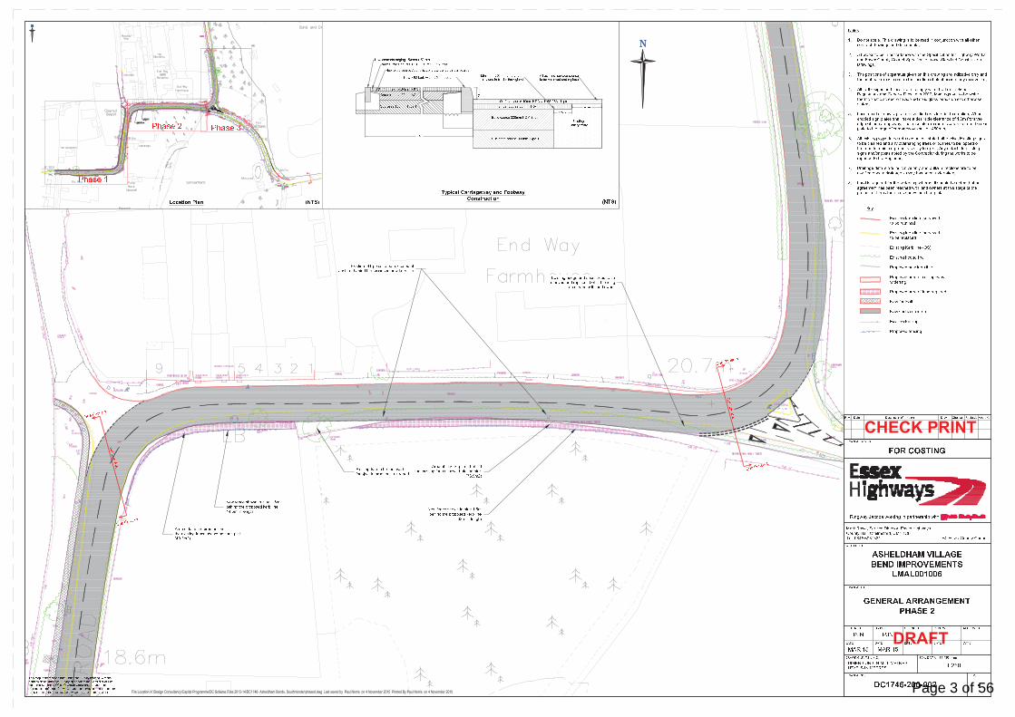
Appendix 1 – Approved Works Programme (March 2016) Additional Information Page 2 to 4 – AWP Scheme 2 LMAL142004 – B1021 Southminster Road/Tillingham Road, Asheldham Design of bend improvements, in three phased approach Page 5 to 17 - AWP Scheme 4 LMAL142008 – Maypole Road, Heybridge Report and design for drainage/verge improvement scheme Page 18 - AWP Scheme 5 LMAL142002 – B1026 Goldhanger Road, Heybridge Technical Note on drainage improvement scheme.
Page 19 to 25 - AWP Scheme 16 LMAL152001 – Steeple Road j/w Grange Avenue, Mayland Works Summary report Page 26 to 41 - AWP Scheme 28 LMAL152015 – Church Lane Stow Maries Report and design for drainage improvement scheme Page 42 to 56 – AWP Scheme 31 LMAL152020 – Beckingham Street/Tolleshunt D’Arcy Road, Tolleshunt Major Design attached for the information of the Panel.
Page 1 of 56
� � � � � � � � � � � � � � � � � � � � � � � � � � � � � � � � � �� � � � � � � � � � � � � � � � � � � � � � � � � �� � � � � � � � � � � � � � � � � � � � � � � � � � � � � � � � � �� � � � � � � � � � � � � � � � � � � � � � � � � �
� � � � � � � � � � � � � � � � � � � � � � � � � � � � � � � � � �
� � � � � � � � � � � � � � � � � � � � � �� � � � � � � � � � � � � � � � � � �� � � � � � � � � � � � � � � � � � � � � � � � � � � � � � � � � � � � � � � � � � � � � �� � � � � � � � � � � � � � � � �� � � � � � � � � � � � � � � � � � � � � � !" # � � � � � � � �� � � � � � � � � � � � � � � � � � � � � � � � � � � �� � � � � � � � � � � � � � � � � � � � � � � � � � � � � � �$ � � � � � � � � � � � � � % � � � � � � � � � � � � &� � � � � � � � � � � � � � � � � � � � � � � � � � � � �� � ' � � � � � � � � � � � � � � � � � � � � � � �
� � � � � � � � � � � � � � � � � � � � � �� � � � � � � � � � � � � � � � � � � � � � � �� � � � � � � � � � � � � � � � � � � � � �� � � � � � � � � � � � � � � � � � � � �� � � � � � � � � � � � � � � � � � � � � � � � � � ' � � � � � � � � � � � � � � � �
� � � � � � � � � � � � � � � � � � � � � � � � � � ' � � � � � � � � � � � � � � � �� � � � � � � � � � � � � � � � � � � � � � � � �� � ' � � � � � � � � � � � � � � � �( � � � � � � � � � � � ) � � � � � � � � �� � � � � � � � � � � � � � � � � �* � � � � � � � � � � * � � � � � � � � � � � �$ + ," + - � + &( � � � � � � � � � � � ) � � � � � � � � �� � � � � � � � � � � � � � � � � �* . � � � � � � � � � * � � � � � � � � � � � �$ ! / �" 0 + � + &
� � � � � � � � � � � � � � � � � � � � � � � � � � �
� � � � � � � � � � � � � � � � � � � � � � � � � � � � � � � � � � � � � � � � � � � � � � � � � � � � � � � � � � � � � � �� � � � � � �� � � � � � � � � � � � � � � � � � � � � � � � � � � � � � �� � � � � � � � � � � � � � � � � � � � � � � � � � � � � � � � � � � � � � � � � � � � � � � � � � � � � ! 0 0 �� � � � �1 � � � � � � � � � � � � � � � � � � � � � � �� � 2 � � � � � � � � � � � � � � � � � � � � � � � �� � � � � � � � � � � � � � � � � � � � �� � � � � �
3456789 :; :<= = > ?@ A= BCD D E FG HD IJ K K LM N O PQ R R S T U V WJ K K LM N O P Q R R S T U V WX YZ [ \ ] X YZ [ \ ^ X Y Z [ \ _abc defg hi cjk lmnk opn qr stuv wxyz {| } wjk lmnk opn qr s~ � � � � � � � � ~ � � � � � � � ������ ��� �� � � � � � � � � � � � � � � � � � �� �
¡¢ £ ¤¥ ¦ § ¦ ¢ £ © § ª «¬ ¬ ® ° ± ² ³ µ ¶ ¡ · ¦ ³ ± ©¹ ±º » § £ ¦ ¢ £ © § «¬ ¬ ®¹ ¥ © § ¦ ¢ £ © § ¼ ¼ «¬ ¬ ½ ¾ ¹ ¥ © §¡¢ ¿À ¿ ¥ © § ¦ ¢ £ © § ¼ « «¬ ¬ Á § à ÄÅ ± © ² ±º ÆÇ ¥ £ £ ± ¥ Æ §° ¥ ÂÈ É ÉÊ Ê Ë Ì Í ÎÏ ÐÃÑ ÒÊ ÓÔÕÖÖ× §° ¦ º ¦ £ § ² § § » Æ ±º Æ Ø µ «¬ ¬ Å µ «¬ ¬¡¢ £ ¤¥ ¦ § ¦ ¢ £ © § Ù «¬ ¬ ®¹ ¥ © § ¦ ¢ £ © § Ø « «¬ ¬ Ç¡¢ ¿ ¿ ¥ © § Ø µ «¬ ¬ Á § Ø× §° © ¢ £ ¤¥ ¦ § ¦ ¢ £ © § Ø µ Ú Ø « Û ©¢ £ ¤ Ø « « Ú Ø µ « » § ©× §° ¿¥ © § ¦ ¢ £ © § ¯ © ³ ¥ Ü ² ± ¦ ¦ º ¦ £ § ² § » §º © § ¿ ±º » § £ ¦ ¢ £ © § ¾ ±º ±¬ ¢ ¬ ¼ « «¬ ¬ © ² § ² ¨ ¿ §£ Ý ± » § » ±º ¿ ±º » § £ ² ³ £ ¢ Æ ³ ¢ ² Ü Ü §Å ± © ² ±º Æ ©¢ £ ¤¥ ¦ § ¦ ¢ £ © §² ¨ ¿ § £ §¬ Ý § » ¥ º » £ § Ü ¥ ¦ §× §° ¹ ¼ Þ § £ ¿ ° ± ² ³ Ø ¼ µ¬ ¬ ¢ © ²¥ º »ß à áâ ã ä å áâ æ ç å æ è éê ë ç é ì æ è ã í æ éî äî ë ç ï ê æ ð ç ñ ã ä ò ç æ á ä óô á ò à ò à çå ç æ ã áâ â á èî è ì í æ é î äî ë ç ïê æ ð ç ñ èî õ ç à ä ó ì è ì ò à ç ö èî ò æ è ó ó ç æ è ì ÷ ç æøù úû ü ýþ ÿ ü � ýù ý �� �û �þ � � � �� û � �� � � �þ � �� ý� � �ù � ý � � � üû �æ ç å æ è éê ë ò á èî á î ì æ á î � çâ ö æ èô î ö è å ñ æ á � à ò äî é ã ä ñ ó ç ä é ò è å æ èâ ç ëê ò á èîè æ ë á ð á ó å æ è ë ç ç é áî � â� �â â ç � ö èê î ò ñ ö èê î ë á ó� � � � � � � � � �� � � � � � � � ! "# $ % %# % % �
& ' ( ' ) * + * ) ) * ( & ' , ' ( -. / * 0 ' �* 0 / ' + � / * , 1 2 + + * & '3 ' ( � 2 , . ) 4 1 ' , ' ( - 0+ , * + % % � % % "#5 � ï 6 7 8 � 55 9 ß � 5 : 9 ; 85 9 ß � ö ÷ � ö < � 55 9 ß � 9 = = : í > � 55 9 ß �5 : 9 ; 6 8 7 ß 6 ß ? �ï ö ÷ � @ � ß 6 ß ? �
5 : 9 ; 6 8 7 8 è� : � >�5 : 9 ; 6 8 7 A 8 6 ß ï A� 8� í� ï ö 9 ? � 9 ß 9 � B C � � D E � � ã ã FG H I J K L H M K L H K I H N N H I J O P J LN J Q J N L H K I J O P J L5 : 9 ; 6 8 7 ï ß 9 ß A ï R 4 ) � 4 0 - 2 ( &
ST U V WI X Y Z P [ \ ]^ L ] Y _ a ] G Y ] a b [ Y^ J c c ] d e f g \ X h ci [ j k b h e X l l ^ i g ] l m c n [ Y op i I q q r eO ] l s t u v w x t y z x y q { J c c ] d i [ j k b h i [ j k a l| } ~ �� �� � � � � � � � � � � } ~ � } ~ � � � � ~ � � � � } � � } � �
� � �� � � S V � � �� � � S V : � > 6 � ; � 55 9 ß �: ç ð� 5 ä ò ç 5 ç â ë æ á å ò á èî è ì æ ç ð á â á è î 5 æ äô î ö à ç ë � ç é : ç ð á çô � é 9 å å æ è ð � é
� ] h J d c b k f Z ] Y � l k ] � c j Y _ ] h ] o �b [ � ] Y ] b X k ] oJ d c b k f Z ] Y � l k ] � c j Y _ ] h ] o �b [ � ] Y ] � l X a ] oJ d c b k f � ] Y � l k ] � M L �J d c b k f g ] o f ] l k ]� Y [ � [ c ] o k ] \ Z ] Y � l k ]� Y [ � [ c ] o X Y ] X [ n a X Y Y X f ] \ X h\ o ] k k f� Y [ � [ c ] o X Y ] X [ n l X k o Y ] � j Y ] oK ] \ n [ [ b � X b gK ] \ c j Y n X a ] a [ j Y c ]J d c b k f n ] k a k f� Y [ � [ c ] o n ] k a k fK [ b ] cq p G [ k [ b c a X l ]p O g c o Y X \ k f c b [ � ] Y ] X o k a [ k � j k a b [ k \ b g X l l [ b g ] Ya [ k b Y X a b o Y X \ k f c X k o o [ a j m ] k b cp�p � l l \ [ Y Z c b [ � ] k X a a [ Y o X k a ] \ b g b g ] L � ] a n a X b [ k n [ Y e f g \ X h [ Y Z cX k o J c c ] d i [ j k b h i [ j k a l L � ] a n a X b [ k c X k o L b X k o X Y o i [ k c b Y j a b [ kG Y X \ k f cpyp O g ] � [ c b [ k c [ n X � � X Y X b j c f _ ] k [ k b g c o Y X \ k f X Y ] k o a X b _ ] [ k l h X k ob g ] a [ k b Y X a b [ Y m j c b a [ k n Y m b g ] l [ a X b [ k [ n � l X k b � Y [ Y b [ X k h ] d a X _ X b [ kpvp � l l b Y X n n a c f k c X k o l k ] c X Y ] b [ a [ m � l h \ b g O g ] O Y X n n a L f k cP ] f j l X b [ k c X k o ¡ ] k ] Y X l G Y ] a b [ k c � t t �p I X Y Z k f c X Y ] b [ � ] \ g b ]b g ] Y m [ � l X c b a c a Y ] ] o \ b g X � � l ] o c [ l o f l X c c � ] X o c j k l ] c c [ b g ] Y \ c ]c b X b ] opwp N [ a X b [ k [ n X l l k ] \ c f k c b [ � ] _ ] Y n ] o [ k c b ] � Y [ Y b [ ] Y ] a b [ kp g ] k] Y ] a b ] o c f k � l X b ] c c g X l l g X _ ] X o ] c Y X � l ] a l ] X Y X k a ] [ n q p t m n Y [ m b g ]] o f ] [ n b g ] a X Y Y X f ] \ X hp O g ] X � c [ l j b ] m k m j m a l ] X Y X k a ] n Y [ m b g ] c f k� l X b ] b [ b g ] ] o f ] [ n a X Y Y X f ] \ X h c g X l l � ] v w t m mpxp � l l ] d c b k f c f k c b [ � ] Y ] b X k ] o j k l ] c c c b X b ] o [ b g ] Y \ c ]p J d c b k f c f k cb [ � ] a l ] X k ] o X k o X k h [ _ ] Y g X k f k f b Y ] ] c [ Y � j c g ] c b [ � ] l [ � � ] o [ Yb Y m m ] o b [ m X k b X k � Y [ � ] Y _ c � l b h b [ c f k cp � k h o ] n ] a b c b [ ] d c b k fc f k c X k o ¢ [ Y � [ c b c k [ b ] o � h b g ] i [ k b Y X a b [ Y o j Y k f b g ] \ [ Y Z c b [ � ]Y ] � [ Y b ] o b [ b g ] J k f k ] ] Ypzp G Y X k X f ] o ] b X l c X Y ] k o a X b _ ] [ k l h X k o [ j b n X l l o Y ] a b [ k c X Y ] b [ � ]a l X Y n ] o [ k a ] X o Y X k X f ] c j Y _ ] h g X c � ] ] k j k o ] Y b X Z ] kpup N X k o c Y ] � j Y ] o n [ Y b g ] \ o ] k k f c a g ] m ]^ b c g [ j l o � ] k [ b ] o b g X b k [ bX f Y ] ] m ] k b g X c � ] ] k Y ] X a g ] o \ b g l X k o [ \ k ] Y c X b b g c c b X f ] [ n b g ]� Y [ � ] a b X k o b g j c b g ] X Y ] X c c g [ \ k g X b a g ] o � k Z
£¤ ¥ ¦§ © ª « « ¦ ¬ ® ¤ ° ±² ² ³ ® ¤ª² ³ « µ § ³ ¦²¶² § ³ ¦² · © ¨ ¹ £ º »
¹ £ º »Page 2 of 56
� � � � � � � � � � � � � � � � � � � � � � � � � � � � � � � � � � � � � � � � �� � � � � � � � � �� � � � � � � � � � � � � � � � � � � � � � � � � � �� � � � � � � � � � � � � � � � � � � � � � � � � � � � � � � � � � � � � � � � � � � � � � � � � � � � � � � � �� � � � � � � � � � � � � � � � � � � � � � � � � � � �� � � � � � � � � � � � � � � � � � � �
� � � � � � � � � � � � � � � � � � � �� � � � � � � � � � � � � � � � � � � � � � � � � � � � �! " #� $ � � %� � � � � � � � � � � � � � � � � � � �� � � � � � � � � � � � � � � � � � � � � � � � � � � � �! & $� # � � % � � � � � � � � � � � � � � � � � � � � � � � � � � � � � � � � � � � � � � � � �& &� � � � � � � � � � � � � � � � � � � � � � � � � � � � � �! � � ' � � � � � � � � � � � � � � � � � � � � � � � %()*+,-. /0 /12 2 3 45 62 712 2 3 45 62 7
89:;<=> ?@ ?12 2 3 45 62 A12 2 3 45 62 A
B C D E F G H E I J C D K L MC D J N D O M I JP O D D Q M RP M I S G D I T D R O F U I O EP T O D J V M I WX Y Z [ \ ] _ D U G D I T D R O F U I M I N H L D a [ b ]N D O M I J P O D V C F V F R D J W D C N HM I DY Y[ b ] M I H D I S P Ocdefghij j k l l m n o p qr s s t u v w xy z z { | } ~ �k l l m n op q� �� � � � � �� � � � � � � � � �� � � � � � � � � � � � � � � � � � ����� ��� �� � � � � � � � �� � � � � � � � � � ¡¢ £¤¥¦§ ¢© ª«¬ ª®° ±²� ¡¢ £¤¥¦ § ¢© ª«¬ ª® ¯° ±²� � � � � � � � ³ � � � � � � � � ³����� ��� �µ ¶ · ¹ º » ¼ ½ · ¾ ¿ À Á Â Ã Ä Å Æ Ç Á ÈÉ Ê ËÌ Í Î Í ÏÉ Ê Ð Î Ñ ÒÓ Ó Ô Õ Ö× Ø Ù Ú Û Ü Ý È Þ Í Ú Øß Ðà Øá â Î Ê Í ÏÉ Ê Ð Î Û ÒÓ Ó Ô Õ Öà Ì Ð Î Í ÏÉ Ê Ð Î ã ã Ò Ó Ó Ô ä å à Ì Ð ÎÈÉ æç æ Ì Ð Î Í ÏÉ Ê Ð Î ã Ò ÒÓ Ó èé ß Î ê ëì Ø Ð Ù Øá íî Ì Ê Ê Ø Ì í Î× Ì éï ð ðñ ñ ò ó ô õö ÷êø ùñ úûüýýþ Î× Í Ïá Í Ê Î Ù Î Î â í Øá í ÿ Ü ÒÓ Ó ì Ü Ò Ó ÓÈÉ Ê ËÌ Í Î Í ÏÉ Ê Ð Î � ÒÓ Ó Ô Õ Öà Ì Ð Î Í ÏÉ Ê Ð Î ÿ Ò ÒÓ Ó Ö îÈÉ æ æÌ Ð Î ÿ Ü Ò Ó Ó èé ß Î ÿþ Î× Ð É Ê ËÌ Í Î Í ÏÉ Ê Ð Î ÿ Ü � ÿ Ò � ÐÉ Ê Ë ÿ Ò Ò � ÿ Ü Ò â Î Ðþ Î× æÌ Ð Î Í ÏÉ Ê Ð Î Ö Ðß Ú Ì � Ù Ø Í Í Ïá Í Ê Î Ù Î â Îá Ð Î æ Øá â Î Ê Í ÏÉ Ê Ð Î å Øá Ø Ó É Ó ã Ò Ò Ó Ó Ð Ù Îß Ù Ï æ Îß Ê Ï � Ø â Î â Øá æ Øá â Î Ê Ù Ú Ê ÏÉ í Ú ÏÉ Ù Ö � � Îì Ø Ð Ù Øá í Ð É Ê ËÌ Í Î Í ÏÉ Ê Ð ÎÙ Ï æ Î Ê ÎÓ Ï � Î â Ì á â Ê Îß � Ì Í Îþ Î× Ô à ã � Î Ê æ × Ø Ù Ú ÿ ã ÜÓ Ó É ß Ð ÙÌ á â
� � � � � � � � � �� � � � � � � �� �� � � � � � � � � � � � � � � � � � � � �� � � � �� � � � � � �� � � �� � � � �� � � � � � � � � � � � � �� � � � � � � � � � � !" # $% & # ' $ $ () *" +% , - - (. " / 0 +) 1 * 0) 2% + (3 4 $5 6 * 7 $ 4) + ( #" 8 � � � �� � � � �� � � � � � 9 � � � �� � � � � � 9 � � �� � � � � � � � � � � � � �� � � ��� � � � � � � � � � � � �� 9 : ; � < � �� � � � � �� � � � �= > ? ? ? > @ A ? B= B ? > C D E F G H IJ K L LJ L L KM N O N P Q R Q P P Q O M N S N O TU V Q W N KQ W V N R D V Q S X Y R R Q M NZ N O D Y S U P [ X N S N O T WR S Q R L L F L L I
J\ ; � ] _ ; \\ � ; \ a b _\ � ; � � ; � c ; \\ � ; d d a � e ; \\ � ;\ a b ] _ � ] � f ;� � � ; g ; � ] � f ;\ a b ] _ _ �: a ; e:\ a b ] _ h _ ] � � h: _: �: � � f ; � > i j C > k l @ C mn o p q r s o t r s o r p o u u o p q v w q su q x q u s o r p q v w q s
\ a b ] _ � � � h � y [ P E [ W T Y O Mz{ | } ~
p � � � w � � �� s � � � � � � n � � � � � � �� q � � � � � � � � � � � �� � � � � � � � � � � � � � � � � � � � �� � p � � � �v � � � � � � � � � ¡ � � ¢ q � � � � � � � � � � � � � � � � �£ ¤ ¥ ¦§ ¨© ª « ¬ ® § ¬ ° ¤ ¥ ¦ ¤ ¥ ± ² ¥ ³ ® ¤ ± § ¤ ²µ ¶ ·¹ º z } µ ¶ ·¹ º z } a ; e ] ; b ; \\ � ;
a � �: \ � � � \ � � � � � � �� � � � � � � � � \ � �� � � � � » � � a � � � � � ¼ � � � � � ¼ �½ � � q � � � � � � � � � � ¾ � � � � ¿ � � � � � � � � À� � ¾ � � � � � � � � �q � � � � � � � � � � ¾ � � � � ¿ � � � � � � � � À� � ¾ � � � Á � � � � �q � � � � � � � ½ � � ¾ � � � � ¿ t s Àq � � � � � � � � � � � � � � � � � � Á � � � � � � � � � � ¾ � � � � � � Á � � � � � � � � � � � � � � � � � � � � �� � � � � � � � � � Á � � � � � � � � � � � � � � � � à � � � � �r � � � � � � Á � � �r � � � � � � � � � � � � � � �q � � � � � � � � � � � � � � � � Á � � � � � � � � � � �
r � � � �� � n � � � � � � � � �� v � � � � � � � � � � � � � � ¾ � � � � � � � � � � Ä � � � � � � � � � � � � � � � � � � �� � � � � � � � � � � � � � � � � � � � � � � � � � � ��Å� Æ � � � � � � � � � ¾ � � � � � � � � � � � � � � � � � � � � s Á � � � � � � � � � � � � � � � � � � � � � Ç � � � �� � � q � � � � � � � � � � � � � � � � � s Á � � � � � � � � � � � � � � � s � � � � � � � � � � � � � � � � � � �n � � � � � � �� � v � � Á � � � � � � � � � � � Á Á � � � � � � � � � � � � � � � � � � � � � � � � � � � � � � � � � � � � � � � � � � � �� � � � � � � � � � � � � � � � � � � � � � � � � � � � � � � � � � � � � Á � � � � Á � � � � � � � � � � � � � � � � � � ���� Æ � � � � � � � � � � � � � � � � � � � � � � � � � � � � � � Á � � � � � � v � � v � � � � � � s � � � �w � � � � � � � � � � � � � È � � � � � � n � � � � � � � � � Å � � Å� p � � � � � � � � � � � � ¾ � � � � � �� � � � � � Á � � � � � � � � � � � � � � � � � Á Á � � � � � � � � � � � � � � ¾ � � � � � � � � � � � � � � � � � � �� � � � � ���� u � � � � � � � � � � � � � � � � � � � � � � ¾ � � � � � � � � � � � � � � � Á � � � � � � � � � � � � � �� Ç � � �� � � � � � � � � � � Á � � � � � � � � � � � � � � � � � � � � � ¾ � � � � � � � � � � � � � � � � � � � � � � � �� � � � � � � � � � � � � � � � � � � �� v � � � ¾ � � � � � � � � � � � � � � � � � � � � � � � � � � � � � � � � �Á � � � � � � � � � � � � � � � � � � � � � � � � � � � � � � � ¾ � � � � � ���� Æ � � � � � � � � � � � � � � � � � ¾ � � � � � � � � � � � � � � � � � � � � � � � � � � � � � �� q � � � � � � � � � � � �� � ¾ � � � � � � � � � � � � � � � � � � � � � � � � � � � � � � � � ¾ � � � � � � � ¾ � � � Á Á � � � �� � � � � � � � � � � � � � � � � Á � � Á � � � � � � ¾ � � � � � � � � � � � �� Æ � � � � � � � � � � � � � � � � � � �� � � � � � � � É � � Á � � � � � � � � � ¾ � � � � � � � � � � � � � � � � � � � � � � � � � � � � � � ¾ �� � Á � � � � � � � � � � q � � � � � � ��¡� n � � � � � � � � � � � � � � � � � � � � � � � � � � � � � � � � � � � � � � � � � � � � � � � � � � � � � � � � ¾ �� � � � � � � � � � � � � � � � � � � � � � � � � � � � � � � ¾ � � � � � � � � � � � � ���� u � � � � � � � à � � � � � � � � � � � � � � � � � � � � � � � � �� � � � � � � � � ¾ � � � � � � � � � � � � �� � � � � � � � � � � � ¾ � � � � � � � � � � � � � � � � � � � � � � � � � � � � � � � � � � � � � � � �Á � � Ä � � � � � � � � � � � � � � � � � � � � � � � � � � � � � � Á � � �ÊË Ì ÍÎ Ï Ð Ñ Ï Ò Ò Í Ï Ó Ô Õ ÏË Ï Ö × ØÙ Ù Ú Õ ÏËÑÙ Ö Û Ú Ò Ü Î Ú ÍÙ ÖÝÙ Î Ï Ú ÍÙ Ö Þ Ð Ï Ö ß à Ê á â ß à Ê á â
Page 3 of 56

� � � � � � � � � � � � � � � �� � � � � � � � � � � � � �
� � � � � � � � � � � � � � � � � � � �� � � � � � � � � � � � � � � � � � � � � � � � � � � � � �� � � � � � � � � � � � � � � � � �� � � � � � � � � � � � � � � � � � � � �� � � � � � � � � � � � � � � � � � � � � � � � � � � � � � � � � � � � � � � � � � � � � ! " � � � � � � � � � � � �� � � � � # � � � � � � � � � � � � � $ � � � � �� � � � � � � � �
� � � � � � � � � � � � � � � � � � � � � � � � � � � � � � � � � � � � � �% � # $ � � � � � � � � # � � # � � � � � � � � &� � � � � � � � ! � � � � � � � � � � � � � � � � � � �� � � � � � # � � � � ' � � � � � � � � � � �� � � � � � � � � � � � � � � � � � � � � � � � � � � � � � � � � � � � � � � � � � � � �
� � � � � � � � ( � � � � � � � � � � � � � � � � � � � � � � � � � � � �) � � � � � � � � � � � � � � � � � � � � � % � � � � � � � � � � � � � � � �* � � &� � � � + # � � � � � � � � � �� � � � � � � � � � � � � � � � � � ,- ./ 01 234 5/ 678 9: 7; < : =>?
,- ./ 01 2 34 5/ 67 8 9: 7 ; < : => ?@A A B CD EA F@A A B CD EA FGHIJKLM NO N
P QR S T U V W X Y S Z[ \ ] ^ _ ` a b c ]d e f g h i j k l e m n o n p e q f l n gr n s t n o m l i n u i k v e i k l w n j n l f li e k l e m n l o i x x n g m f q t l ev o e y i g n z x q p n f o f k q n {o e x l | n k n sq f o o i f j n s f }~ �i hl i k j � n k q n l e m n o n l f i k n g� � � x x q p n f o f k q n l e m n x f i kl f i k n gd e f g h i j k l e m n o np e q f l n g s i l | � � � x xq p n fo f k q n l e l | n k n s q f o o i f j n s f }� � � | f x m no l e m n o n p e q f l n gd e f g h i j k l e m n o np e q f l n g s i l | � � � x xq p n fo f k q n l e l | n k n s q f o o i f j n s f }~ �i hl i k j e f t l o n n l e m n o nl f i k n g� h � m � n q l l e f o m e o i q � pl � o f p o n v e o l �r n s { n k q n h | e s k i k m p � n z � � xm n | i k g l | n v o e v e h n g t n o m p i k n�� x i k p n k jl | ~ � i h l i k j � hp f k g f k g h i j k h l e m n o np e q fl n g f h h | e s k~ �i h li k j � � v e p n h l e m n o n p e q fl n g flp n f h l z x m n |i k g l | n v o e v e h n g k n s t n o m pi k nd n g � k g f k l v e h l m e � v e h ll e m n o n x e y n g l e l i v ~ � i h l i k j | n g j n f k g h x f p p l o n n h l e m no n x ey n g f k g o n v p f q n g m n | i k g { n k q i k jf h f j o n n g s i l | p f k g e s k n o� o n f e { p f k g o n � � i o n g m n | i k gl | n n � i h l i k j { n k q n h | e s k | f l q | n g v i k t� � � � � x � �� o n f e { p f k g o n � � i o n g m n | i k gl | n n �i h l i k j { n k q n h | e s k | f l q | n g vi k t� � � � � x � � r n s { n k q n h | e s k i k m p � n z � � xm n | i k g l | n vo e v e h n g t n o m pi k n� � � � x i k p n k j l | ~ � i hl i k j l o n n l e m n o n x e y n g� h � m� n ql l e fo m e o i q � p l �o fp o n v e o l �~ � i hl i k j � � q | f x m no l e m n o n p e q f l n g i k y n o j n e oo n q e k h l o � ql n g l e q � s h v n qi { i q f l i e k~ �i h l i k j � � q | f x m n o l e m n o np e q fl n g i k y no j n e oo n q e k hl o � ql n g l e q � s h v n q i{ i q fl i e k~ �i hl i k j � � � | e k n m e � l e m n o n p e q f l n g i k y n o j n~ � i h l i k j � � � r � � � v e p n l e m no n p e q fl n g m n | i k g { e e l s f }~ �i hl i k j v e h l m e � l e m n o n p e q f l n gm n | i k g l | n v o e v e h n g { e e l s f }� k � x m no e f t v e hl h l e m no n x e y n g l e l i v� o e v v n g t n o m h z � � x s i g n l e m nv o e y i g n g e v v e h il n y n | i qp n qo e h hi k jl e vo ey i g n f k i k { e o x f p qo e h hi k j v e i kl� l f ql i p n v f y i k j r � � l e m n v o e y i g n g �~ � i h l i k j { i o n | } go f k l l e m n o n l f i k n gf g � f q n k l t n o m l e m n v fi k l n g } n pp e s~ � i hl i k j v f o i h | hi j k f k g mi kl e m n o n p e q f l n g m n | i k g l | n { e el s f }~ �i hl i k j y i pp f j n h i j k l e m no n p e q fl n g m n | i k g l | n { e e l s f } ~ � i hl i k j j � p p } l e m n o n p e q fl n g f g � f q n k l l e k n s t n o m p i k n~ �i hl i k j j � p p } l e m n o n p e q fl n g f g� f q n k l l e k n s t n o m p i k n~ �i h li k j j � p p } h l e m n o n p e q f l n gf g� f q n k l l e k n s t no m p i k n� o n f e { p f k g o n � � io n g m n | i k gl | n f h h � x n g m e � k g f o } e {� | n � � k j fp e s h | e s k | fl q | n g v i k t� � � � � � x �� � o n f e { p f k g o n � � i o n g m n |i k gl | n f h h � x n g m e � k g f o } e{� e o k n o � p el h | e s k | fl q | n g v i k t� z � � � � � x � �~ � i l i k j q e k i{ n o l o n n l e m n o n x e y n g~ � i h l i k j � � q | f x m n o l em n o n p e q f l n g i k { e e l s f } ~ �i hl i k j � � v e p n l em n o n p e q f l n g m n | i k g{ e el s f }~ � i hl i k j � � � r v ep n l em n o np e q f l n g m n | i k g{ e e l s f } ~ � i hl i k j | n g j n l e m n o n x e y n g ����� ¡¢¢ £ ¤ ¤ ¥ ¦ § ©ª « « ¬ ® °± ² ² ³ µ ¶ ·± ² ² ³ µ¶ ·¸¹º»¼½¾ ¸ ¸± ² ² ³ µ ¶ ·¿ À À Á  ÃÄ ÅÆ ÇÈ É Ê Ë r n s o e f g x f o t i k j h l e g i f j o f x z � � �s i l | � iu g i o n ql i e k f p s | i l n o e f g h l � g hf l �x q n k l n o h l | o e � j | e � l k n s h �o { f q nr n s { e e l s f } l e m n vo e y i g n gf h h | e s k Æ ÇÈ É Ê Ì Æ ÇÈ É Ê ÍÎÏÐÑÒÓÔÕ ÕÖ × × Ø Ù Ú Û × ÜÝ Þ Þ ß à á â Þ ãä å å æ ç è é å êë ì ì í î ï ð ì ñ òóôõö÷øùùä å å æ ç è é å úû ü ü ý þ ÿ � ü �� x f p p h n ql i e k e { l n x v eo fo } t n o m� h | e s k i k x f j n k l f u z z � � x�x f } m n o n � � io n g g n v n k gi k je k v o e j o f x e{ v | f h i k j � �� � �� �� � � � ��� �� � �� �� � � � �� �� � � � ��� �� � �� �û ü ü ý þ ÿ � ü � ä å å æ ç è é å �òóôõö÷øùù� � � � � � � ! " � # $ % & ' ( ) * + , & -. / 01 2 3 2 4. / 5 3 6 7 8 8 9 : ; < = > ? @ A B - C 2 ? =D 5E =F G 3 / 2 4. / 5 3 @ 7 8 8 9 : ;E 1 5 3 2 4. / 5 3 H H 7 8 8 9 I J E 1 5 3-. KL K 1 5 3 2 4. / 5 3 H 7 7 8 8 MN D 3 O PQ = 5 > =F RS 1 / / = 1 R 3 < 1 NT U UV V W X Y Z[ \O] ^V _`abbc 3 < 2 4F 2 / 3 > 3 3 G R =F R d A 7 8 8 Q A 7 8 8-. / 01 2 3 2 4. / 5 3 e 7 8 8 9 : ;E 1 5 3 2 4. / 5 3 d 7 7 8 8 ; S-. K K 1 5 3 d A 7 8 8 MN D 3 dc 3 < 5. / 01 2 3 2 4. / 5 3 d A f d 7 g 5. / 0 d 7 7 f d A 7 G 3 5c 3 < K 1 5 3 2 4. / 5 3 ; 5D ? 1 h > = 2 2 4F 2 / 3 > 3 G 3F 5 3 K =F G 3 / 2 4. / 5 3 J =F = 8. 8 H 7 7 8 8 5 > 3D > 4 K 3D / 4 i = G 3 G =F K =F G 3 / > ? / 4. R ? 4. > ; h h 3Q = 5 > =F R 5. / 0 1 2 3 2 4. / 5 3> 4 K 3 / 3 8 4 i 3 G 1 F G / 3D h 1 2 3c 3 < 9 E H j 3 / K < = > ? d H A 8 8 . D 5 > 1 F G
k l mn o p q mn r s q r t uv w s u x r t o y r uz pz w s { v r | s } o p ~ s r m p � � m ~ l ~ l sq s r o mn n m tz t x y r u z pz w s {v r | s } tz � s l p � x t x ~ l s � tz ~ r t � � s r t x � s r�� �� � �� � � � �� � �� �� �� � � � �� � � � �� � � �� �� � �� � �� � �� � � �� � � �� �r s q r t uv w ~ m tz m z x r m z � sn � r t �z � t q } r m � l ~ pz u o p } � s p u ~ t q r tn s wv ~ m tzt r w m | m � q r t w s s u mz � n� n n s ¡ � tv z ~ } � tv z w m �¢ £ ¤ ¤ ¤ £ ¥ ¦ ¤ §¢ § ¤ £ © ª « ¬ ®¯ « ° °¯ ° ° ±² ³ ³ µ ¶ · ¶ µ µ ¶ ² ³ ³ ¹º » ¶ ¼ ³ ±¶ ¼ » ³ · © » ¶ ½ ¾ · · ¶ ² ³¿ ³ © ¾ º µ À ½ ³ ³ ¹ ¼· ¶ · ° ° « ° ° ®
¯Á { Â Ã Ä ÁÁ Å k Á Æ Å Ç ÄÁ Å k � � � È ÁÁ Å k Å É É Æ y Ê ÁÁ Å k Á Æ Å Ç Â Ä Ã k  k Ë { � � Ì k  k Ë Á Æ Å Ç Â Ä Ã Ä t� Æ Ê�Á Æ Å Ç Â Ä Ã Í Ä Â k { Í� Ä� y� { � Å Ë Å k Å £ Î Ï £ Ð Ñ ¥ o o ÒÓ Ô Õ Ö × Ø Ô Ù × Ø Ô × Õ Ô Ú Ú Ô Õ Ö Û Ü Ö ØÚ Ö Ý Ö Ú Ø Ô × Õ Ö Û Ü Ö Ø
Á Æ Å Ç Â Ä Ã { k Å k Í { Þ À µ ª À ¼ ¹ ¾ ²ßà á â ã
Õ ä å æ Ü ç è éê Ø é å ë ì í é Ó ì å é í î ç åê Ö ï ï é ð ñ ì ò ó è ä ô ïõ ç ö ÷ î ô ñ ä ø ø ê õ ó é ø ù ï ú ç å ûü õ Õ ý ý þ ñÛ é ø ÿ � � � � � � � � � � ý � Ö ï ï é ð õ ç ö ÷ î ô õ ç ö ÷ í ì ø� �� � � � � � � � � � � � � � � � � � � � � � �� � �� � � ß â � � �� � � ß â Æ Ê Â Ç ÁÁ Å k
Æ s |� Á p ~ s Á s n w r m q ~ m tz t x r s | m n m t z Á r p �z � l s w s u Æ s | m s � ! u Å q q r t | ! u" é ô Ö ð ì ï î ì ÷ ò æ é å # ø ì ÷ é $ ï ö å ë é ô é û %î ç # é å é î ä ì ÷ é ûÖ ð ì ï î ì ÷ ò æ é å # ø ì ÷ é $ ï ö å ë é ô é û %î ç # é å é & ø ä í é ûÖ ð ì ï î ì ÷ ò " é å # ø ì ÷ é $ Ù Ø %Ö ð ì ï î ì ÷ ò ó é û ò é ø ì ÷ é' å ç & ç ï é û ÷ é è æ é å # ø ì ÷ é' å ç & ç ï é û ä å é ä ç ú í ä å å ì ä ò é è ä ôè ì û é ÷ ì ÷ ò' å ç & ç ï é û ä å é ä ç ú ø ä ÷ û å é ( ö ì å é û× é è ú ç ç î & ä î ó× é è ï ö å ú ä í é í ç ö å ï éÖ ð ì ï î ì ÷ ò ú é ÷ í ì ÷ ò' å ç & ç ï é û ú é ÷ í ì ÷ ò
× ç î é ïý ü Ó ç ÷ ç î ï í ä ø éü Û ó ì ï û å ä è ì ÷ ò ì ï î ç # é å é ä û ì ÷ í ç ÷ ) ö ÷ í î ì ç ÷ è ì î ó ä ø ø ç î ó é åí ç ÷ î å ä í î û å ä è ì ÷ ò ï ä ÷ û û ç í ö ù é ÷ î ïü*ü + ø ø è ç å æ ï î ç # é ì ÷ ä í í ç å û ä ÷ í é è ì î ó î ó é Ø & é í ì ú ì í ä î ì ç ÷ ú ç å ñ ì ò ó è ä ô , ç å æ ïä ÷ û Ö ï ï é ð õ ç ö ÷ î ô õ ç ö ÷ í ì ø Ø & é í ì ú ì í ä î ì ç ÷ ï ä ÷ û Ø î ä ÷ û ä å û õ ç ÷ ï î å ö í î ì ç ÷Ó å ä è ì ÷ ò ïü�ü Û ó é & ç ï ì î ì ç ÷ ï ç ú ä & & ä å ä î ö ï ò ì ë é ÷ ç ÷ î ó ì ï û å ä è ì ÷ ò ä å é ì ÷ û ì í ä î ì ë é ç ÷ ø ô ä ÷ ûî ó é í ç ÷ î å ä í î ç å ù ö ï î í ç ÷ ú ì å ù î ó é ø ç í ä î ì ç ÷ ç ú & ø ä ÷ î & å ì ç å î ç ä ÷ ô é ð í ä ë ä î ì ç ÷ü�ü + ø ø î å ä ú ú ì í ï ì ò ÷ ï ä ÷ û ø ì ÷ é ï ä å é î ç í ç ù & ø ô è ì î ó Û ó é Û å ä ú ú ì í Ø ì ò ÷ ïÜ é ò ö ø ä î ì ç ÷ ï ä ÷ û - é ÷ é å ä ø Ó ì å é í î ì ç ÷ ï * � � *ü Õ ä å æ ì ÷ ò ï ä å é î ç # é è ó ì î éî ó é å ù ç & ø ä ï î ì í ï í å é é û è ì î ó ä & & ø ì é û ï ç ø ì û ò ø ä ï ï # é ä û ï ö ÷ ø é ï ï ç î ó é å è ì ï éï î ä î é ûü�ü Ú ç í ä î ì ç ÷ ç ú ä ø ø ÷ é è ï ì ò ÷ ï î ç # é ë é å ì ú ì é û ç ÷ ï ì î é & å ì ç å î ç é å é í î ì ç ÷ü , ó é ÷é å é í î é û ï ì ò ÷ & ø ä î é ï ï ó ä ø ø ó ä ë é ä û é ï ì å ä # ø é í ø é ä å ä ÷ í é ç ú ý ü � ù ú å ç ù î ó éé û ò é ç ú î ó é í ä å å ì ä ò é è ä ôü Û ó é ä # ï ç ø ö î é ù ì ÷ ì ù ö ù í ø é ä å ä ÷ í é ú å ç ù î ó é ï ì ò ÷& ø ä î é î ç î ó é é û ò é ç ú í ä å å ì ä ò é è ä ô ï ó ä ø ø # é � � � ù ùü�ü + ø ø é ð ì ï î ì ÷ ò ï ì ò ÷ ï î ç # é å é î ä ì ÷ é û ö ÷ ø é ï ï ï î ä î é û ç î ó é å è ì ï éü Ö ð ì ï î ì ÷ ò ï ì ò ÷ ïî ç # é í ø é ä ÷ é û ä ÷ û ä ÷ ô ç ë é å ó ä ÷ ò ì ÷ ò î å é é ï ç å # ö ï ó é ï î ç # é ø ç & & é û ç åî å ì ù ù é û î ç ù ä ì ÷ î ä ì ÷ & å ç & é å ë ì ï ì # ì ø ì î ô î ç ï ì ò ÷ ïü + ÷ ô û é ú é í î ï î ç é ð ì ï î ì ÷ òï ì ò ÷ ï ä ÷ û . ç å & ç ï î ï ÷ ç î é û # ô î ó é õ ç ÷ î å ä í î ç å û ö å ì ÷ ò î ó é è ç å æ ï î ç # éå é & ç å î é û î ç î ó é Ö ÷ ò ì ÷ é é åü�ü Ó å ä ì ÷ ä ò é û é î ä ì ø ï ä å é ì ÷ û ì í ä î ì ë é ç ÷ ø ô ä ÷ û ç ö î ú ä ø ø û ì å é í î ì ç ÷ ï ä å é î ç # éí ø ä å ì ú ì é û ç ÷ í é ä û å ä ì ÷ ä ò é ï ö å ë é ô ó ä ï # é é ÷ ö ÷ û é å î ä æ é ÷ü�ü Ú ä ÷ û ì ï å é ( ö ì å é û ú ç å î ó é è ì û é ÷ ì ÷ ò ï í ó é ù éê ì î ï ó ç ö ø û # é ÷ ç î é û î ó ä î ÷ ç îä ò å é é ù é ÷ î ó ä ï # é é ÷ å é ä í ó é û è ì î ó ø ä ÷ û ç è ÷ é å ï ä î î ó ì ï ï î ä ò é ç ú î ó é& å ç ) é í î ä ÷ û î ó ö ï î ó é ä å é ä ï ï ó ç è ÷ ó ä î í ó é û & ì ÷ æ
Page 4 of 56
Maypole Road Safety Improvements Highway Improvements Design Team
JANUARY 2016
Title
Sub title (inc Bridge no.) Date
Page 5 of 56
1
HIDT 2015/16 DC1817 MAYPOLE ROAD DRAINAGE STUDY FEB 16
Document Control Sheet
Document prepared by: Highway Improvements Design Team
Paul Norris Engineer
Highways County Hall A2 Annexe Chelmsford Essex. CM1 1QH
T 0845 603 7631 E [email protected]
W www.essex.gov.uk/highways
Record of Issue
1 Approved MBS FEB16
Distribution
Report Title Maypole Road Safety Improvements
Project Number DC1817
Status Approved
Revision -
Control Date February 2016
Issue Status Author Date Check Date Authorised Date
Organisation Contact Number of Copies
Page 6 of 56
2
HIDT 2015/16 DC1817 MAYPOLE ROAD DRAINAGE STUDY FEB 16
Contents
1 Executive Summary ................................................................. 3
2 Scheme Brief ............................................................................ 4
2.1 Collision data ....................................................................................... 4
3 Discussion on piping the ditch ............................................... 5
3.1 Why can’t the whole ditch be piped now? ........................................ 5
3.2 Why is partial piping being considered? .......................................... 5
3.3 Why will the development help? ........................................................ 6
4 Short term measures ............................................................... 8
5 Conclusions ........................................................................... 10
Appendix 1: Short Term Proposed Measures
Appendix 2: Collision Data
Page 7 of 56

3
HIDT 2015/16 DC1817 MAYPOLE ROAD DRAINAGE STUDY FEB 16
1 Executive Summary
The Local Highways Panel (LHP) is concerned regarding the proximity of the
open ditch to the carriageway along Maypole Road and the risk of vehicles
entering the ditch as a result.
Extensive investigation was undertaken in 2015 into piping the ditch – however
this concluded that piping this in its entirety is not currently an option as it will
further increase the flood risk to Holloway Road (see cover picture).
Removing the ditch will also having other detrimental impacts such as loss of
capacity, ecological benefits, and ease of access for maintenance.
Partial piping may be an option to reduce the risk of vehicles entering the ditch.
However the implementation of such infrastructure will result in the installation
of solid structures (headwalls) that could significantly increase the severity of
injury if a collision did occur.
A major housing development is proposed which will bisect Maypole Road and
provide a significant flood alleviation scheme. This scheme will divert run off
from both the surface water system in Maypole Road and Holloway Roads.
Once the flood alleviation work has been completed (proposed for 2017/18) it
will be possible to pipe the ditch in its entirety without increasing the flood risk
downstream.
The development has now received outline permission thus is expected to be in
place and operational within two years. (Jan 2018).
In light of this development and the timescales involved a low cost interim
measure to directly address the issue identified has been proposed.
This solution involves the creation of an upstand along the existing verge with
the use of soil filled sand bags to protect the ditch.
The cost of this proposal has been estimated at £45,000.
Page 8 of 56
4
HIDT 2015/16 DC1817 MAYPOLE ROAD DRAINAGE STUDY FEB 16
2 Scheme Brief
A request was received from the Maldon Local Highways Panel (LHP) to
complete a feasibility study to investigate measures to improve safety at the
edge of carriageway along the southern section of Maypole Road. The request
was made following a series of incidents where vehicles left the carriageway
and drove into the adjacent ditch.
2.1 Collision data
The latest 3 year collision data ending 31/12/15 was considered for the route
and this showed that no there have been no recorded personal injury collisions
(PIC’s) on this section of Maypole Road within this period.
The investigation period was increased to the last 10 years, and this showed
only 4 recorded collisions within the section, the most recent of which was in
May 2009 (almost 7 years ago).
Of these 4 collisions only 1 resulted in vehicles ending up in the ditch, this
occurred in February 2006 (10 years ago) and resulted in a slight injury.
This collision involved a southbound car overtaking a pedal cycle, in the path of
a northbound vehicle and although the pedal cycle and the overtaking vehicle
ended up in the ditch, this feature was not a contributing factor which led to the
collision. Overtaking without looking properly and excessive speed were
reported by Essex Police.
The collision data has been provided in Appendix 2.
With such a low collision rate and only 1 personal injury collision recorded in the
10 year period involving the ditch it is difficult to justify significant expenditure.
Page 9 of 56
5
HIDT 2015/16 DC1817 MAYPOLE ROAD DRAINAGE STUDY FEB 16
3 Discussion on piping the ditch
3.1 Why can not the whole ditch be piped now?
The ditch due to the vegetation in the bottom is considered to be rough which
slows the water as it flows around the roots and other vegetation – if the ditch
were to be piped with a large diameter pipe (required for capacity) the speed of
flow would increase as the pipe is smooth without obstructions.
This would have the effect of delivering the water to the Holloway Road culvert
quicker and therefore increasing the likelihood of flooding in Holloway Road.
This risk is already significant with a number of flood events in recent years.
If a smaller pipe were used (to reduce the flow reaching the Holloway Road
culvert) the run off from the fields would be too great and the excess water
would run down the carriageway which would again result in an increased flood
risk downstream.
Essex County Councils current policy is against the piping of ditches unless
absolutely necessary, this is for a number of reasons including loss of capacity,
loss of ecological habitat, ease of future access for maintenance and
monitoring, and open ditches also provide a level of water treatment of the
water passing through which pipes do not provide.
Given these factors piping the ditch as a whole has been discounted, until the
surface water run-off has been reduced by the development.
3.2 Why is partial piping being considered?
Piping only sections of the ditch will allow the flow to still be ‘slowed’ but allow
for some storage of water in the ditch sections between the piped sections
during significant rain events, and will maintain the benefits of open ditches,
detailed above in these sections.
However this design has been based on a theoretical model and would require
flow monitoring over an appropriate time period to ensure that the assumptions
made and conclusions reached regarding flood risk are sound.
Page 10 of 56

6
HIDT 2015/16 DC1817 MAYPOLE ROAD DRAINAGE STUDY FEB 16
The ECC Flood Management Team have not been able to recommended a time
period for this monitoring as it will need to encompasses a significant
measurable rain event, and these cannot be predicted.
The benefit of partial piping must also be assessed, the risk presented by the
height difference between the carriageway and the bottom of the ditch will only
be removed in parts, i.e. vehicles could still leave the carriageway on the un-
piped sections.
Also head walls will be required at the start and end of each piped section and
this will introduce solid structures which could increase the severity of injuries if
vehicles did enter the ditch.
If partial piping is implemented and if the remainder of the water course is to be
piped on the completion of the North Heybridge development, the pipe size will
need to be consistent or access chambers will be required at each change in
diameter – this will result in an increased overall cost.
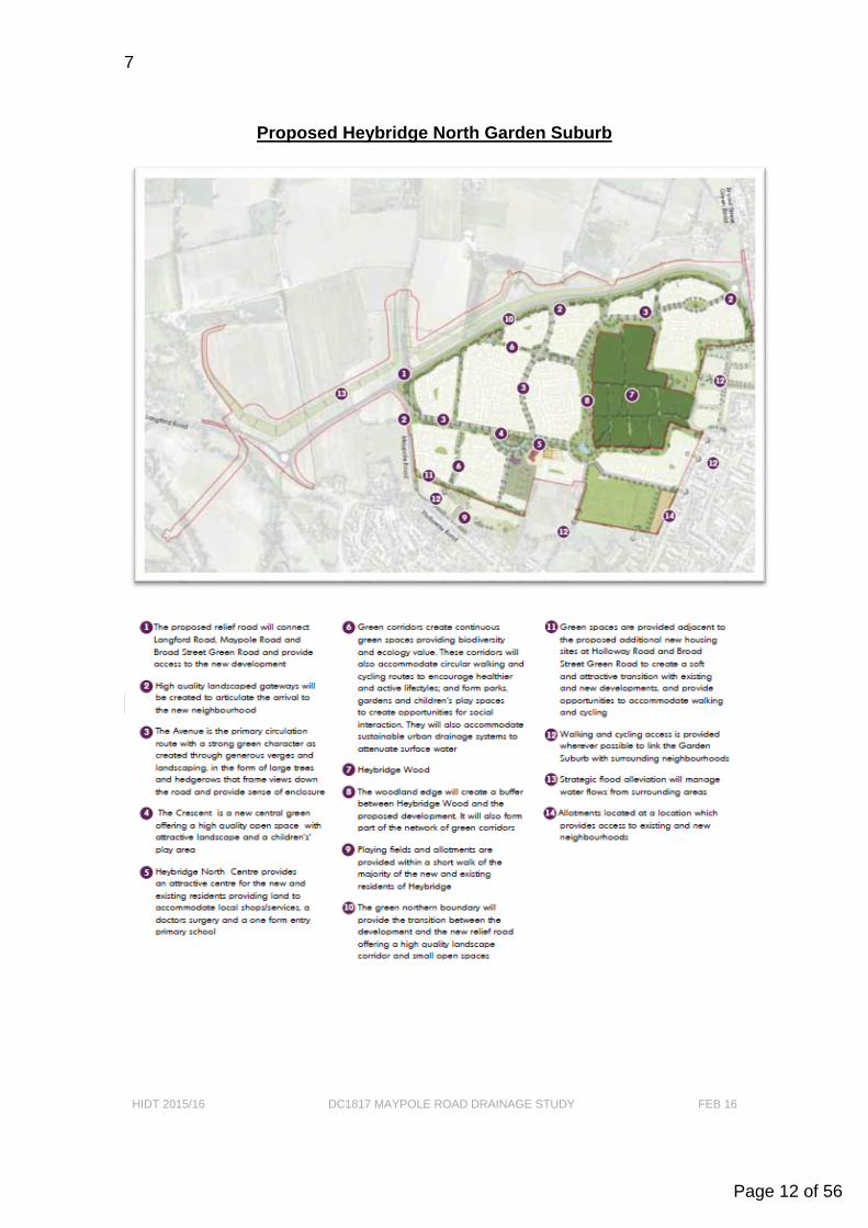
3.3 Why will the development help?
The development proposals include a large earth bund and drainage system
which will collect much of the water which currently runs off the surrounding
land. This will then be diverted west into the River system, therefore significantly
reducing the run off into the Maypole Road ditch.
This will significantly reduce the capacity required adjacent to Maypole Road
and therefore provide alleviation for the Holloway Road system which has
capacity issues downstream.
In light of the development and the reduction in surface water run off which will
result, a low cost interim measure could be considered in the short term, and full
piping in the medium term.
Any works post development will require the run-off to be recalculated to
account for the reduced area, so that an appropriate pipe size can be designed.
Page 11 of 56
7
HIDT 2015/16 DC1817 MAYPOLE ROAD DRAINAGE STUDY FEB 16
Proposed Heybridge North Garden Suburb
Page 12 of 56
8
HIDT 2015/16 DC1817 MAYPOLE ROAD DRAINAGE STUDY FEB 16
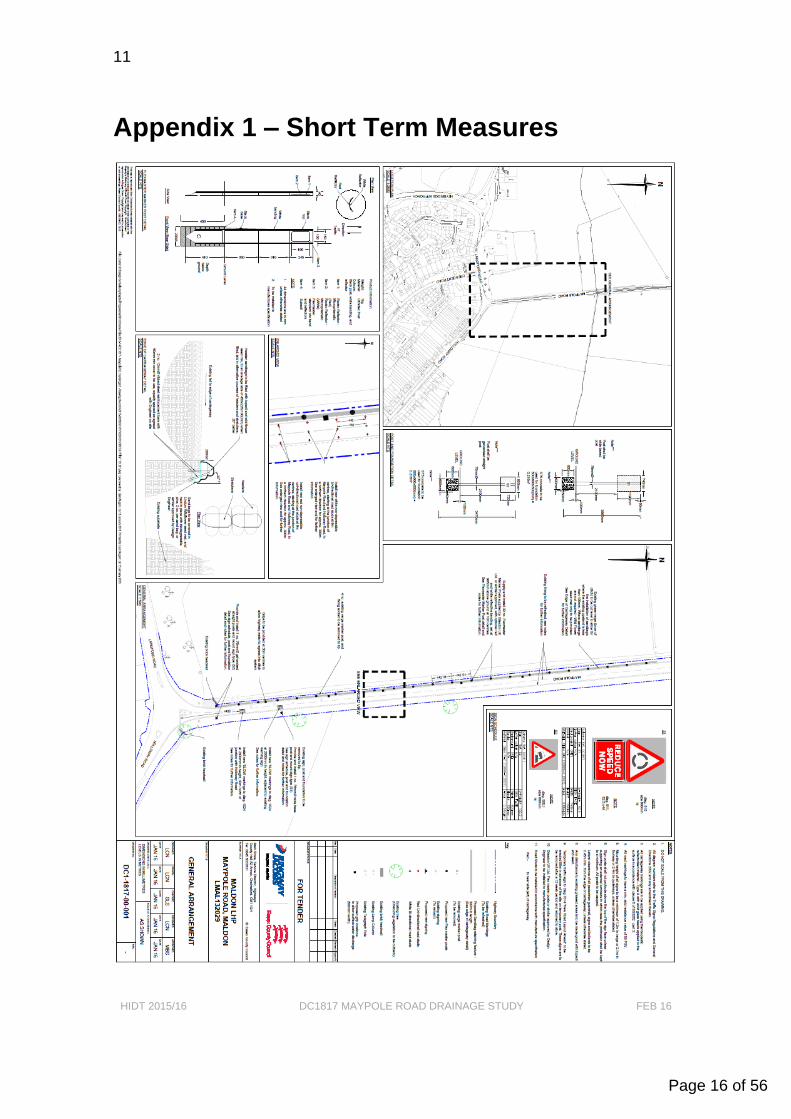
4 Short term measures
Although the personal injury collision data does not identify the ditch as a
contributory factor, there have been a further two damage only accident
recorded by Essex Police within the section. The detail of these is limited,
however the ditch was not mentioned in either incident.
It is possible, however that there are further unrecorded damage only incidents,
along this section of Maypole Road which along with the perceived risk, have
led the request from the LHP for measures to be provided.
Unfortunately, as the ditch is so close to the carriageway kerbing the verge is
not possible as there is insufficient verge width to support the kerb and backing
(it’s likely to fall in the ditch and cause an obstruction to the flow – particularly if
struck by a vehicle).
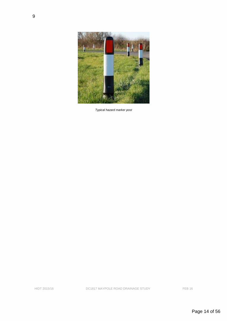
Hazard marker posts are also often used to highlight road side hazards
however these must have 450mm clearance from the carriageway edge is not
currently available throughout the length.
Therefore at this location a bespoke solution is required, a plan showing the
proposed short term measures has be provided in Appendix 2.
The proposal is to use topsoil filled sand bags covered with a wild flower seed
mat, to provide a ‘green’ upstand at the edge of the carriageway which will knit
in with the existing verge vegetation to achieve a ‘buffer’ between the
carriageway and the ditch.
The wild seed flower mat which is to be laid over the top of the sand bags
should establish quickly providing both visual and environmental benefits for the
area.
The planting should be well established by the time the development has been
completed and therefore should continue to enhance the verge if the ditch is
piped in the future.
Increasing the verge height and width should also allow further hazard marker
posts to be provided, these have been detailed on the scheme drawing.
Page 13 of 56
9
HIDT 2015/16 DC1817 MAYPOLE ROAD DRAINAGE STUDY FEB 16
Typical hazard marker post
Page 14 of 56
10
HIDT 2015/16 DC1817 MAYPOLE ROAD DRAINAGE STUDY FEB 16
5 Conclusions
Piping the ditch in its entirety is not an option at this time as it WILL increase the
flood risk in Holloway Road as explained in section 2.1.
Partial piping will only partially address the issue and has been estimated to
cost £200,000.
Post completion of the measures to divert the run off which will be constructed
as part of the development, a smaller pipe diameter would be required and this
could be provided throughout the ditch length.
These factors lead to the conclusion that it would not be prudent to pipe the
ditch at this time.
The short term measures proposed should cost around £45k which is only
around 20% of the cost of partial piping, and therefore felt to be justifiable
expenditure to address the identified issue and enhance the local environment,
both environmentally and visually, pre and post development.
As this is a bespoke solution it is recommended that first a trial should be
undertaken on a short section to ensure the design is practicable and performs
as intended.
If the short term measures are particularly successful it may remove the need to
pipe the ditch at all which would be beneficial for the local wildlife which will
suffer some habitat lost from the development.
The wild flowers would have a better chance of establishing if planted in the
spring, therefore completing the scheme in April/May 2016 is recommended.
Page 15 of 56
11
HIDT 2015/16 DC1817 MAYPOLE ROAD DRAINAGE STUDY FEB 16
Appendix 1 – Short Term Measures
Page 16 of 56

12
HIDT 2015/16 DC1817 MAYPOLE ROAD DRAINAGE STUDY FEB 16
Appendix 2: Collison Data
Please refer to the attached accident data.
Page 17 of 56

Scheme Reference: HI4163 Goldhanger Road, Maldon Drainage Investigation
Date: 16 March 2016 Author: Liam Nugent (HIDT SMO2)
Technical Note The Maldon Local Highway Panel (LHP) has funded a feasibility/options study for
drainage improvements on B1026 Goldhanger Road, Heybridge, between its junction
with Lawling Avenue and Basin Road.
The SMO2 Highway Improvements Design Team (HIDT) have been commissioned
through a design brief to investigate the following:-
Arrange meeting with Maintenance Revenue team to discuss works undertaken to date and any remaining maintenance issues.
Arrange meeting with Flood Management team to discuss scope of drainage improvements undertaken and confirm any future scheme proposals
Arrange meeting with enforcement team to discuss any identified issues with water draining from adjacent land, unmaintained ditches and hedges.
Visit site to identify areas where flooding of highway continue to occur.
Obtain Highway Boundary and confirm ditch ownership along area of interest
Produce a costed option report for presentation to LHP.
Obtain stats
Update Senior Engineer and Programme Coordinator on scheme progress Following discussions with the Flood Management team, it has been identified that some work is being undertaken to improve the flooding issues on Wagtail Drive, although this was deemed to have no direct impact on the flooding issues further downstream on Goldhanger Road. An initial site investigation has been undertaken to determine what apparatus currently exists on site, with the view to see what condition they are in. A camera survey and cleaning operation is currently being organised to assist with determining the current situation. Members of our enforcement team have been in touch with the land owners, whose field currently run adjacent to Goldhanger Road, to politely remind them of their responsibility to maintain their watercourse. We are currently in process of organising a meeting with the land owners and our colleagues from enforcement to discuss the next steps of this process. Once the jetting/camera survey has been completed, a clearer picture can be established, regarding exactly what apparatus there is within the site, and what condition it’s in, judgment and decisions can then be made to determine the correct solution.
Page 18 of 56
Page 1 of 7
HI4009 Steeple Road jw Grange Avenue, Mayland
Summary Note
Background and summary of validation report and actions taken
The requirement for this investigation was set out in the scheme validation report dated
07/01/2014.
The scheme validation request from the Parish Council identified that road users were having
difficulty emerging from the junction due to the speed of traffic along the Steeple Road. Their
proposal was to install a mini roundabout to slow vehicles on the main road and allow
vehicles to exit Grange Avenue.
The subsequent validation identified that a mini roundabout would not be supported by Essex
Highways as Steeple Road is classified as a PR2 route. PR2s perform an essential traffic
management distributor function between the local network and Priority One County Routes
where priority is given to vehicular traffic on the major road. Furthermore, Grange Avenue
forms a link between two PR2 routes and introduction of a mini roundabout would encourage
further rat running than what is already occurring.
Finally, Steeple Road is also subject to a 40mph speed limit so a mini roundabout would also
be against national guidelines.
Other issues raised in the scheme validation report were as follows:
a) Cut back vegetation on approach to junction (open up visibility)
b) Cut back vegetation obscuring signage
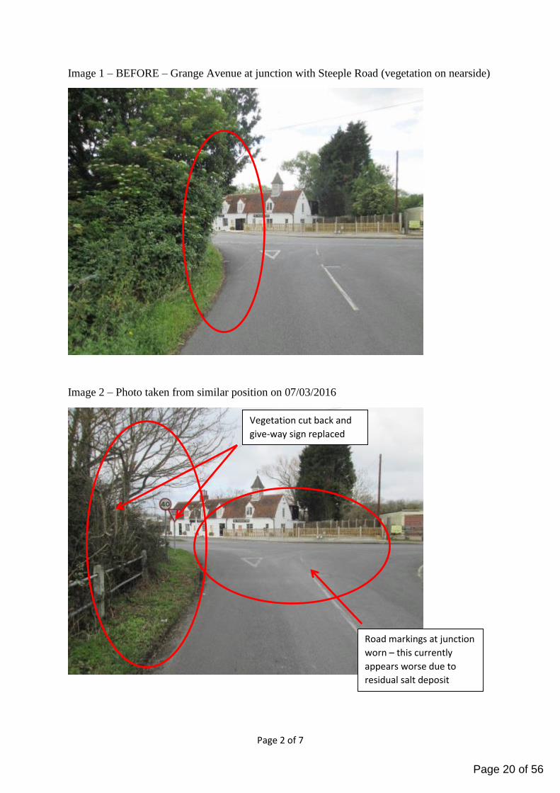
Vegetation along the nearside of Grange Avenue has been cut back and the damaged give-
way sign at the junction replaced.
Also noted during the site inspection was that road markings are in poor condition along
Steeple Road, particularly the give-way markings at the junction. This has been reported to
maintenance however, is currently viewed as low priority, and given that the give-way sign
has also been replaced and forward visibility to the junction cleared of vegetation, there is
considered to be minimal risk of somebody overshooting the junction.
Page 19 of 56
Page 2 of 7
Image 1 – BEFORE – Grange Avenue at junction with Steeple Road (vegetation on nearside)
Image 2 – Photo taken from similar position on 07/03/2016
Vegetation cut back and
give-way sign replaced
Road markings at junction
worn – this currently
appears worse due to
residual salt deposit
Page 20 of 56
Page 3 of 7
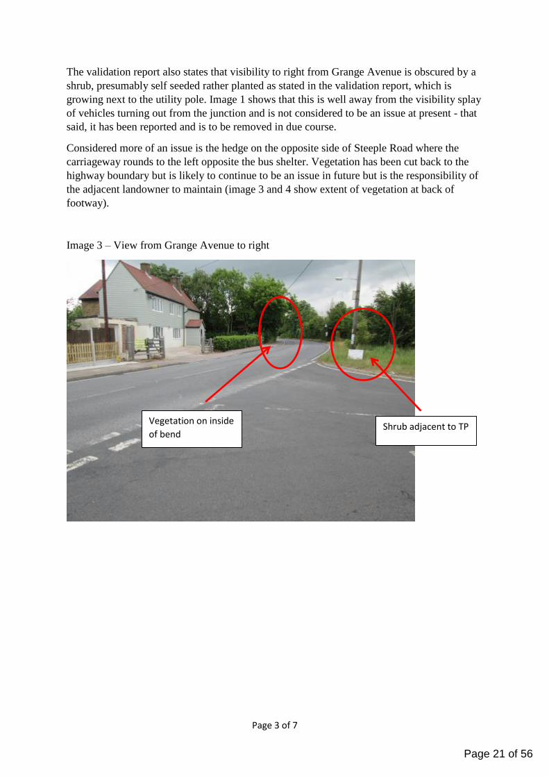
The validation report also states that visibility to right from Grange Avenue is obscured by a
shrub, presumably self seeded rather planted as stated in the validation report, which is
growing next to the utility pole. Image 1 shows that this is well away from the visibility splay
of vehicles turning out from the junction and is not considered to be an issue at present - that
said, it has been reported and is to be removed in due course.
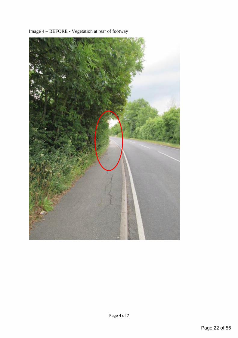
Considered more of an issue is the hedge on the opposite side of Steeple Road where the
carriageway rounds to the left opposite the bus shelter. Vegetation has been cut back to the
highway boundary but is likely to continue to be an issue in future but is the responsibility of
the adjacent landowner to maintain (image 3 and 4 show extent of vegetation at back of
footway).
Image 3 – View from Grange Avenue to right
Shrub adjacent to TP Vegetation on inside
of bend
Page 21 of 56
Page 4 of 7
Image 4 – BEFORE - Vegetation at rear of footway
Page 22 of 56
Page 5 of 7
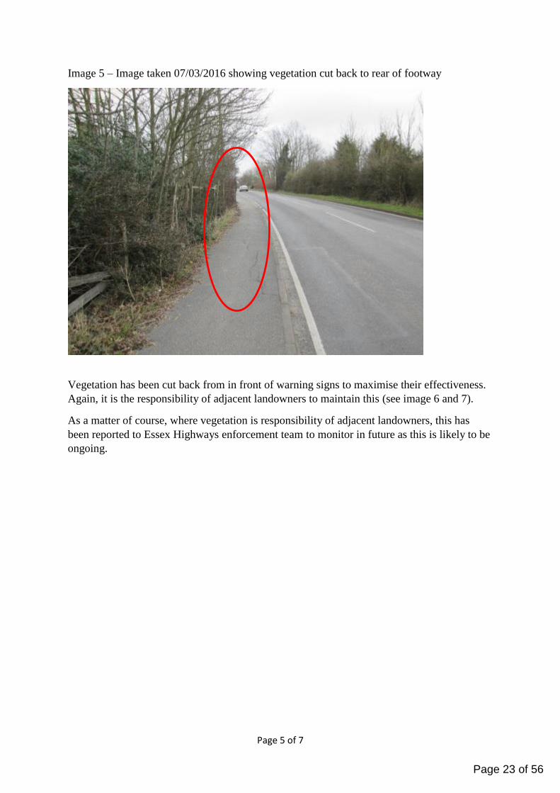
Image 5 – Image taken 07/03/2016 showing vegetation cut back to rear of footway
Vegetation has been cut back from in front of warning signs to maximise their effectiveness.
Again, it is the responsibility of adjacent landowners to maintain this (see image 6 and 7).
As a matter of course, where vegetation is responsibility of adjacent landowners, this has
been reported to Essex Highways enforcement team to monitor in future as this is likely to be
ongoing.
Page 23 of 56
Page 6 of 7
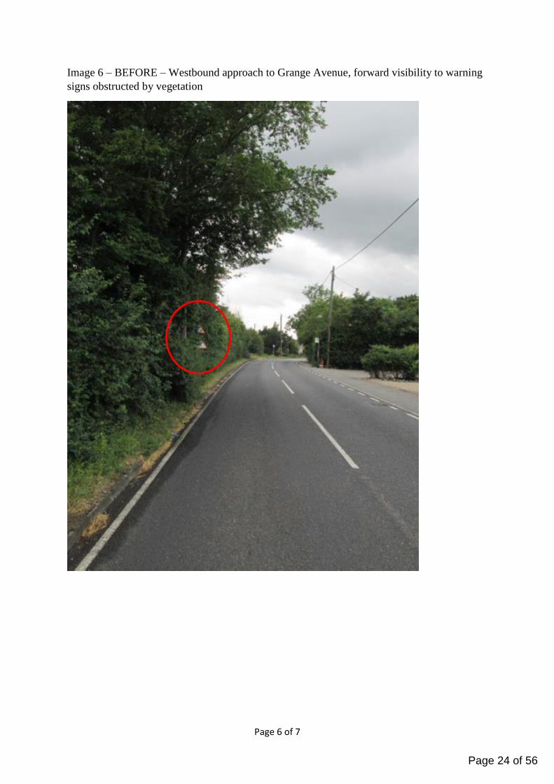
Image 6 – BEFORE – Westbound approach to Grange Avenue, forward visibility to warning
signs obstructed by vegetation
Page 24 of 56
Page 7 of 7
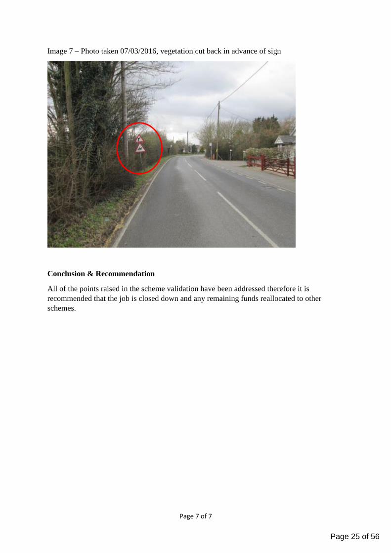
Image 7 – Photo taken 07/03/2016, vegetation cut back in advance of sign
Conclusion & Recommendation
All of the points raised in the scheme validation have been addressed therefore it is
recommended that the job is closed down and any remaining funds reallocated to other
schemes.
Page 25 of 56
Page 26 of 56
Page 27 of 56

Page 28 of 56
Page 29 of 56
Page 30 of 56
Page 31 of 56

Page 32 of 56
Page 33 of 56
Page 34 of 56
Page 35 of 56

Page 36 of 56

Page 37 of 56
Page 38 of 56
Page 39 of 56
Page 40 of 56
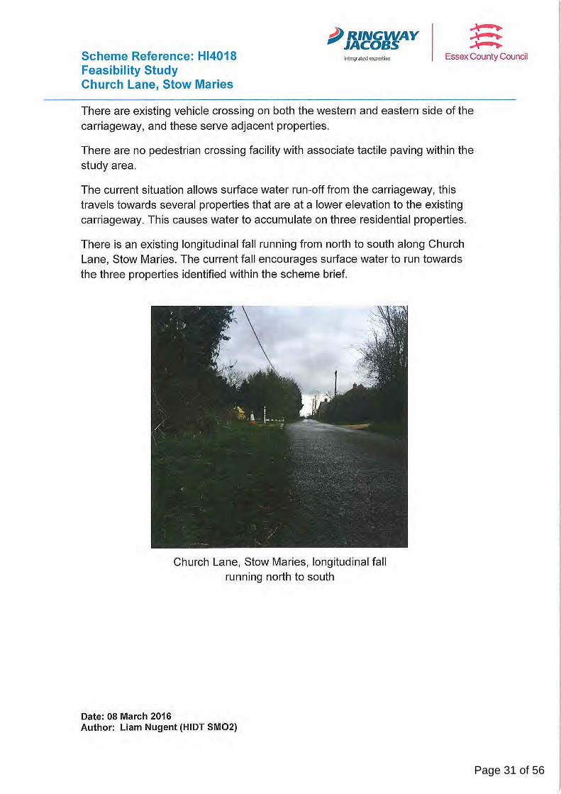
SEE GENERAL ARRANGEMENT
STOW
MARIES
C
H
U
R
C
H
L
A
N
E
W
O
O
D
H
A
M
R
O
A
D
T
H
E
S
T
R
E
E
T
S
T
R
A
C
K
T
R
E
B
O
E
T
H
F
O
U
R
E
L
M
S
G
L
E
B
E
L
A
N
D
S
C
H
U
R
C
H
L
A
N
E
H
B
2
H
B
2
D
K
-L
D
K
-R
B
N
NOTE
Existing kerb line to remain
H
B
2
H
B
2
D
K
-L
D
K
-R
B
N
H
B
2
H
B
2
D
K
-L
D
K
-R
B
N
Mortar bed to BS.
7533-6: 1999
Paragraph 4
40mm AC10 close
surface course 100/150 to
BN13108-1
Base
Precast concrete kerb, type BN
Subbase
ST1 concrete bed and
backing to SHW
clauses 1101 and
2602.
Key made in wet
concrete to the
approval of the
engineer
150
325
Ke
rb
b
ed
th
ickn
ess
25
Existing fall towards
property to remain
Existing carriageway
NOTES
1. ALL DIMENSIONS ARE IN MILLIMETRES
2. Topsoil shall be as described in the contract
3. Kerbs may be laid and bedded as shown or
directly on an ST1 concrete foundation in
accordance with ECC folio dwg. EB105.
HI-4018-05-001 -
DESIGNED
DATE
DRAWN
DATE
CHECKED
DATE
APPROVED
DATE
DRAWING No. REV.
DRAWING UNITS U.N.O. SCALE AT A3 (420x297mm)
DIMENSIONS IN MILLIMETRES
LEVELS IN METRES
DRAWING STATUS
LCN
FEB 16
LCN
FEB 16
SLS
FEB 16 FEB 16
AS SHOWN
This map is reproduced from Ordnance Survey material with the
permission of Ordnance Survey on behalf of the Controller of Her
Majesty’s Stationery Office © Crown Copyright. Unauthorised
reproduction infringes Crown Copyright and may lead to prosecution or
civil proceedings. Essex County Council, 100019602, 2015
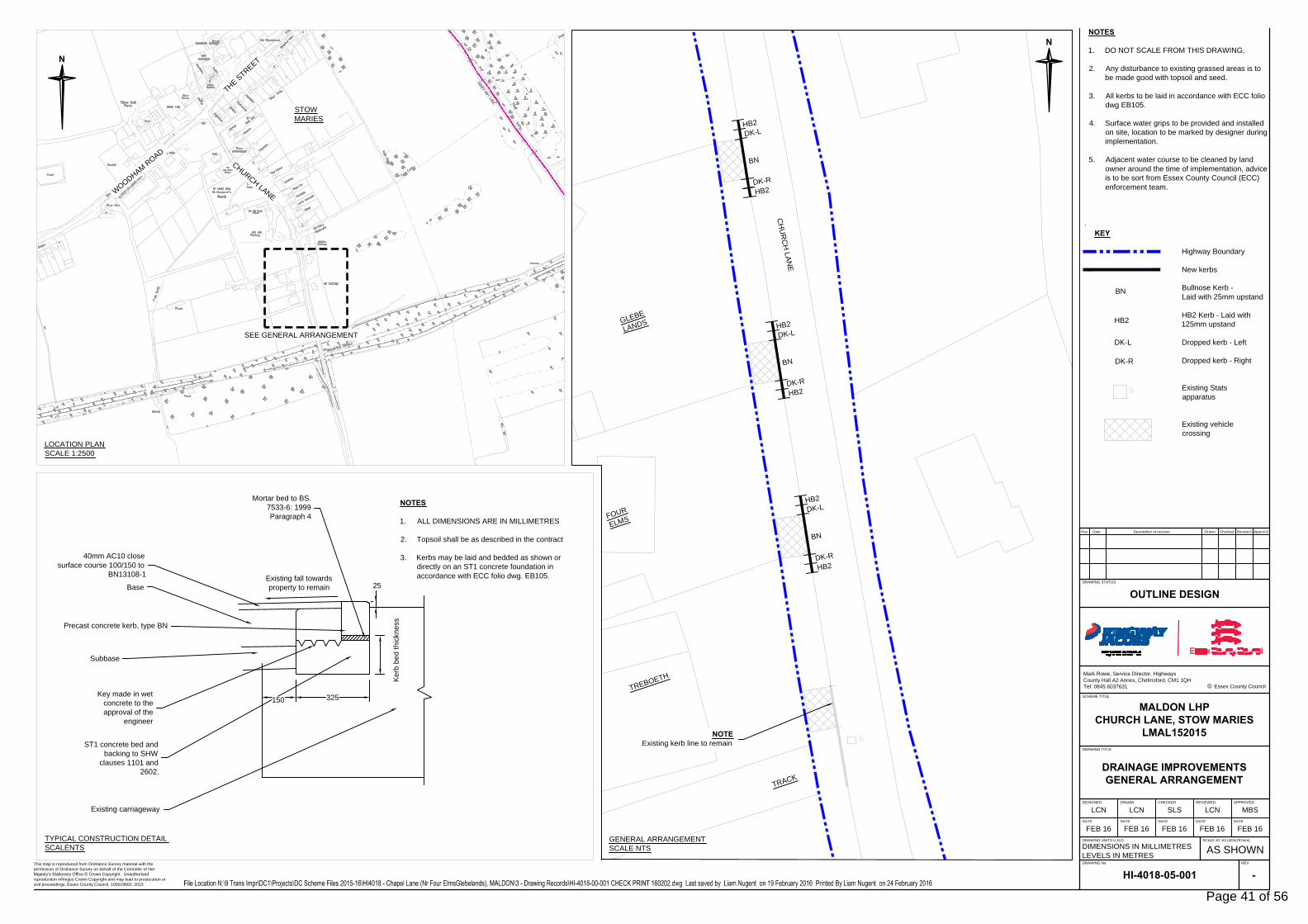
DRAINAGE IMPROVEMENTS
GENERAL ARRANGEMENT
MALDON LHP
CHURCH LANE, STOW MARIES
LMAL152015
DRAWING TITLE
SCHEME TITLE
Mark Rowe, Service Director, Highways
County Hall A2 Annex, Chelmsford. CM1 1QH
Tel: 0845 6037631 © Essex County Council
OUTLINE DESIGN
REVIEWED
DATE
LCN
FEB 16
N
MBS
Rev. Date Description of revision Drawn Checked Review'd Approv'd
N
LOCATION PLAN
SCALE 1:2500
GENERAL ARRANGEMENT
SCALE NTS
KEY
Highway Boundary
New kerbs
Bullnose Kerb -
Laid with 25mm upstand
HB2 Kerb - Laid with
125mm upstand
Dropped kerb - Left
Dropped kerb - Right
Existing Stats
apparatus
Existing vehicle
crossing
BN
HB2
DK-L
DK-R
S
NOTES
1. DO NOT SCALE FROM THIS DRAWING.
2. Any disturbance to existing grassed areas is to
be made good with topsoil and seed.
3. All kerbs to be laid in accordance with ECC folio
dwg EB105.
4. Surface water grips to be provided and installed
on site, location to be marked by designer during
implementation.
5. Adjacent water course to be cleaned by land
owner around the time of implementation, advice
is to be sort from Essex County Council (ECC)
enforcement team.
TYPICAL CONSTRUCTION DETAIL
SCALENTS
Page 41 of 56
Essex Highways - Report Template
Tolleshunt D’Arcy Road Junction with Beckingham Street Tolleshunt Major
Junction Improvement Study February 2016
Page 42 of 56
Document Control Sheet
Document prepared by: Paul Norris Design Engineer
Highways County Hall A2 Annexe Chelmsford Essex. CM1 1QH
T 0845 603 7631 E [email protected] W www.essex.gov.uk/highways
Record of Issue
1 Final P Norris 29FEB16 MBS 29FEB16
Distribution
Ringway Jacobs Jon Simons Electronic
Report Title Junction Improvement study – Tolleshunt Major
Tolleshunt Major Junction Improvement Study
Project Number HI 4021
Status Final
Revision Rev B
Control Date 08 March 2016
Issue Status Author Date Check Date Authorised Date
Organisation Contact Number of Copies
Page 43 of 56

Contents
1 Introduction ........................................................................... 1-4
2. Site Observations ................................................................. 1-7
3 Junction Options .................................................................. 1-9
3.1 Standard T Junction (Option 1) ....................................................... 1-9
3.2 Standard T Junction with Pedestrian Island (Option 2) .............. 1-10
3.3 Skewed T Junction (Option 3) ....................................................... 1-11
3.4 Mini Roundabout (Option 4) .......................................................... 1-12
3.5 Changing Junction Priority (Option 5) ......................................... 1-13
4 The Preferred Option .......................................................... 1-14
5 The Next Steps .................................................................... 1-15
Page 44 of 56

1 Introduction
This report has been written for and on behalf of Essex County Council (ECC) as part of the Local Highways Panels (LHP) which have been established in all 12 districts of Essex. These panels consist of County and District/Borough Members who meet on a quarterly basis to discuss and mutually consider Highways expenditure within their local district or borough boundaries. This note is to be presented to the Maldon LHP to review and comment, propose further actions, feasibility of the options and report the findings back to ECC. Tolleshunt Major Parish council have identified a problem with the junction of
Beckingham Street / Tolleshunt D’Arcy Road / Witham Road Tolleshunt Major.
They have stated that continuous damage is being caused by vehicles
especially by HGV’s turning at the junction (towards Beckingham Business
Park). The Bennett Island at the junction is being overrun, kerbs are being
damaged and the finger post is in need of repair. There is also concern here for
pedestrians with an increased use of the nearby church rooms and the local
playing field.
HGV Route Signing
The signed HGV route to Beckingham Business Park from the A12 is via Loamy
Hill Road, The Street, and School Road and there is a directional sign at the
Witham Road cross roads directing HGV’s south away from the junction in
question.
Page 45 of 56

However a review of the signed HGV route as a whole may be beneficial if it
can be confirmed that the vehicles in question are indeed attempting to access
the business park.
The Bennett island junction format was first conceived by Mr G T Bennett in
1947 when his book ‘Road Junctions: Suggestions for Improved Designs’ was
published – although no records can be found of when the current junction was
installed it is estimated that it was in the 1950’s when vehicles and traffic
volume and speeds were very different from today.
Following the safety concerns expressed by the parish council the latest 3 year
accident Personal injury accident data was collected and this showed there
have been no personal injury accidents at the junction.
Vehicle tracks have been undertaken for movements at the existing junction
and provided below is an extract of the track for a right turn into Witham Road
for the 16.5m design vehicle. This shows that only around 1.5m of the
carriageway remains available for southbound vehicles, therefore even smaller
vehicles are likely to create overrun when they meet on this section.
Turning manoeuvre 16.5m design vehicle
This compounds the conclusion that the available carriageway is insufficient for
modern vehicles
A number of options have been considered for the junction, both within the
existing highway boundary and with the benefit of the land to the west of the
junction which is understood to be in the ownership of the Church Rooms and
thus is potentially available for this improvement.
Page 46 of 56
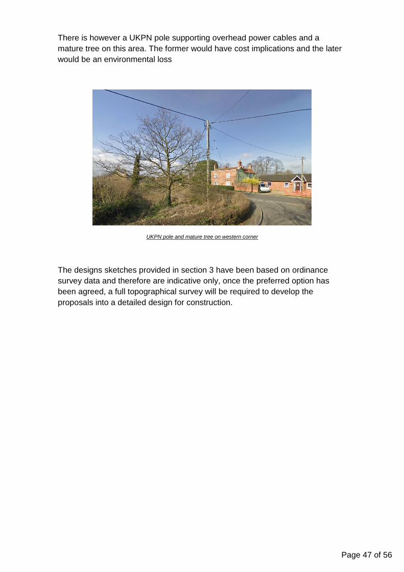
There is however a UKPN pole supporting overhead power cables and a
mature tree on this area. The former would have cost implications and the later
would be an environmental loss
UKPN pole and mature tree on western corner
The designs sketches provided in section 3 have been based on ordinance
survey data and therefore are indicative only, once the preferred option has
been agreed, a full topographical survey will be required to develop the
proposals into a detailed design for construction.
Page 47 of 56
2. Site Observations
The route is well used by local traffic to access the primary road network and
has a high proportion of HGV’s accessing the business park. It was noted that
the alignment of Tolleshunt D’Arcy Road relative to Witham road encourages
higher speeds as this manoeuvre is almost straight – a few drivers did not even
appear to look to check the road is clear when making this turn.
Evidence of over run at the island was noted on site particularly for the right turn
into Witham road. Although there was also evidence along all carriageway
edges of overrun.
There is a water supply service valve within the central island and therefore
work on the statutory undertaker’s plant is likely to be required to ensure that
the plant is to carriageway specification before the island can be removed.
There is also a finger post directional sign on the island, this will need to be
relocated.
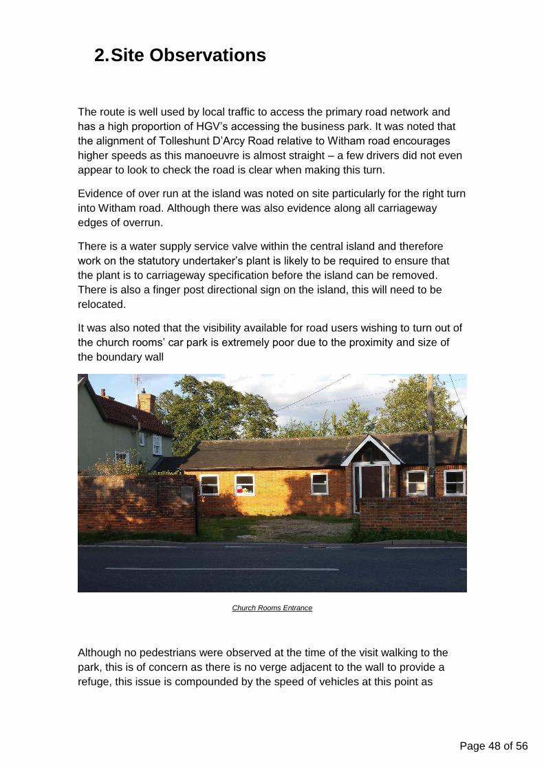
It was also noted that the visibility available for road users wishing to turn out of
the church rooms’ car park is extremely poor due to the proximity and size of
the boundary wall
Church Rooms Entrance
Although no pedestrians were observed at the time of the visit walking to the
park, this is of concern as there is no verge adjacent to the wall to provide a
refuge, this issue is compounded by the speed of vehicles at this point as
Page 48 of 56
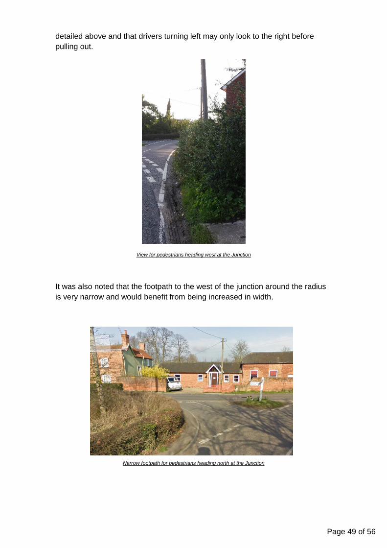
detailed above and that drivers turning left may only look to the right before
pulling out.
View for pedestrians heading west at the Junction
It was also noted that the footpath to the west of the junction around the radius
is very narrow and would benefit from being increased in width.
Narrow footpath for pedestrians heading north at the Junction
Page 49 of 56
3 Junction Options
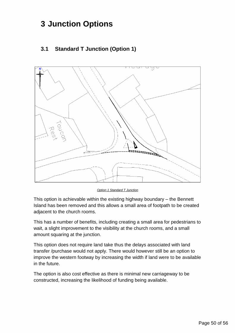
3.1 Standard T Junction (Option 1)
Option 1 Standard T Junction
This option is achievable within the existing highway boundary – the Bennett
Island has been removed and this allows a small area of footpath to be created
adjacent to the church rooms.
This has a number of benefits, including creating a small area for pedestrians to
wait, a slight improvement to the visibility at the church rooms, and a small
amount squaring at the junction.
This option does not require land take thus the delays associated with land
transfer /purchase would not apply. There would however still be an option to
improve the western footway by increasing the width if land were to be available
in the future.
The option is also cost effective as there is minimal new carriageway to be
constructed, increasing the likelihood of funding being available.
Page 50 of 56
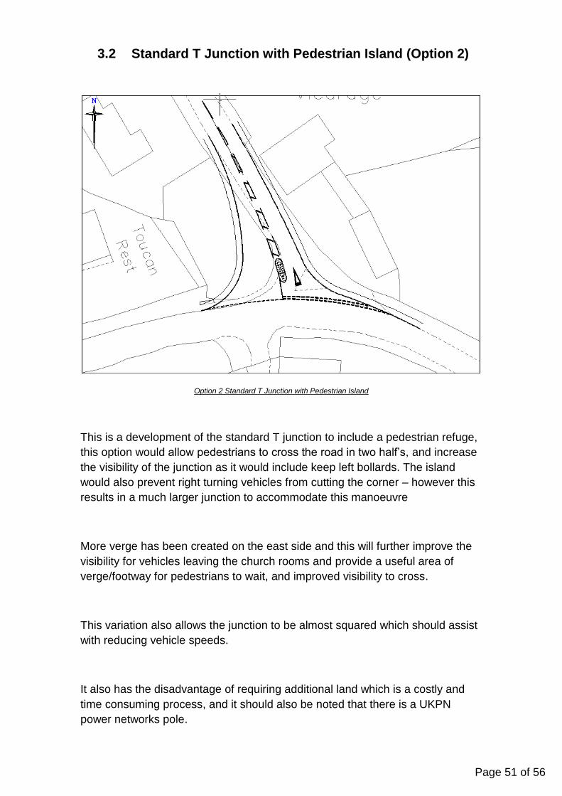
3.2 Standard T Junction with Pedestrian Island (Option 2)
Option 2 Standard T Junction with Pedestrian Island
This is a development of the standard T junction to include a pedestrian refuge,
this option would allow pedestrians to cross the road in two half’s, and increase
the visibility of the junction as it would include keep left bollards. The island
would also prevent right turning vehicles from cutting the corner – however this
results in a much larger junction to accommodate this manoeuvre
More verge has been created on the east side and this will further improve the
visibility for vehicles leaving the church rooms and provide a useful area of
verge/footway for pedestrians to wait, and improved visibility to cross.
This variation also allows the junction to be almost squared which should assist
with reducing vehicle speeds.
It also has the disadvantage of requiring additional land which is a costly and
time consuming process, and it should also be noted that there is a UKPN
power networks pole.
Page 51 of 56
3.3 Skewed T Junction (Option 3)
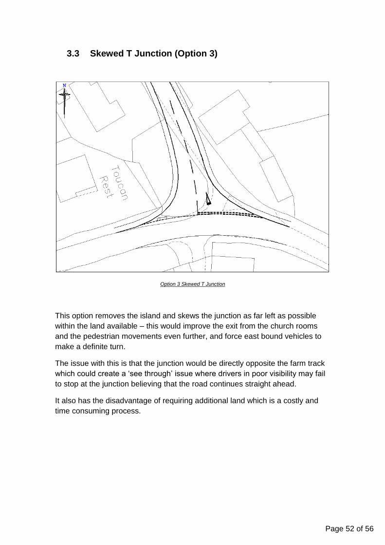
Option 3 Skewed T Junction
This option removes the island and skews the junction as far left as possible
within the land available – this would improve the exit from the church rooms
and the pedestrian movements even further, and force east bound vehicles to
make a definite turn.
The issue with this is that the junction would be directly opposite the farm track
which could create a ‘see through’ issue where drivers in poor visibility may fail
to stop at the junction believing that the road continues straight ahead.
It also has the disadvantage of requiring additional land which is a costly and
time consuming process.
Page 52 of 56
3.4 Mini Roundabout (Option 4)
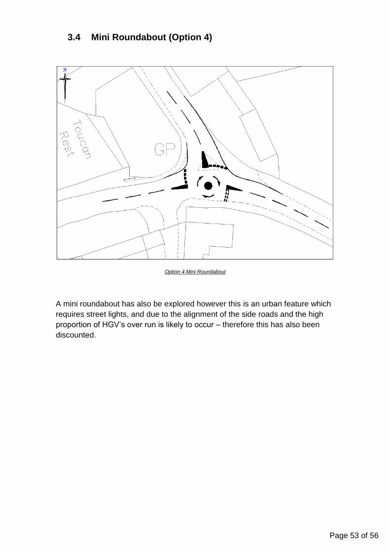
Option 4 Mini Roundabout
A mini roundabout has also be explored however this is an urban feature which
requires street lights, and due to the alignment of the side roads and the high
proportion of HGV’s over run is likely to occur – therefore this has also been
discounted.
Page 53 of 56

3.5 Changing Junction Priority (Option 5)
Option 5 Changing Priority
Although explored changing the junction priority is not recommended at this
location. Given the site observations regarding the vehicle speeds for vehicles
travelling north to east, this change is very likely to increase speeds through the
village and on Tolleshunt D’Arcy Road.
For this reason this option has not been explored further.
Page 54 of 56
4 The Preferred Option
Option 1 (simple T junction) is considered to be the best overall option for this
junction, this will achieve most of the objectives of the scheme and therefore
represents good value as it is also the lowest cost scheme, and should be
relatively quick to deliver as all the land is in highway ownership. An order of
cost has been prepared and for this option the cost has been estimated at
£45,000
Option 2 (T junction with Pedestrian Island) would achieve all the objectives of
the scheme, however the additional land, and significant areas of construction
required would again result in this option being costly and difficult to deliver. It
would also be difficult to justify this additional cost as the number of pedestrians
crossing the junction is relatively low and even once the island is provided is
unlikely to increase to significantly enough to warrant this additional
expenditure. An order of cost has been prepared and for this option the cost has
been estimated at £125,000
Option 3 (skewed T junction without an island) would achieve the objectives of
the scheme, however the potential ‘see through’ issue which could develop is a
significant concern, and the land requirements result in a costly scheme which
would take time to undertake the land transfer and therefore implement. Given
these issues this option has also been discounted. An order of cost has been
prepared and for this option the cost has been estimated at £120,000
Option 4 and 5 (a mini roundabout and a change in priority) have already been
discounted as detailed in section 3.
Therefore the conclusion following this study is to provide Option 1 – a
simple t junction.
Page 55 of 56

5 The Next Steps
Once the preferred junction format has been agreed a full topographical survey
is recommended to ensure that the OS data is correct and allow surface level
information to be collected.
The topographical survey data will allow the Detailed Design to be undertaken
including drainage, surface levels, signs etc.
As soon as the detailed design has been completed the statutory undertakes
can be contacted to provide estimates to move/lower there plant to suit the new
junction.
In parallel with the stats estimates, the target costing of the scheme can also be
completed and with the benefit of the detailed design this should provide some
cost certainty.
Once completed the Target Cost and Stats Costs then can be used to seek the
necessary funding from the Local Highway Panel to implement the scheme.
Page 56 of 56

MALDON DISTRICT LOCAL HIGHWAYS PANEL
POTENTIAL SCHEMES LIST (Version 19)
As part of the Essex County Council 2016/17 budget, which was agreed at Full Council on 9 February 2016, it was announced that the budget for Local Highways Panels (LHP) would be halved. This means for Maldon District LHP the available 2016/17 capital funding will be £200,000. It is recommended in 2016/17 that the panel make further scheme funding recommendations to create an £320,000 rolling programme of works. Currently within the rolling programme there are schemes which have been re-profiled from 2015/16 to the value of £228,800. With a £320,000 rolling programme this would for £91,200 of Capital monies the Panel can use to make further funding recommendations in 2016/17.
2016/17 Budget Summary
Item Amount
Capital Funding 2015/16 £200,000
Recommended Rolling Programme £320,000
Programmed Works re-profiled from 2015/16 into 2016/17 £228,800
Capital funding available to make recommendations against 2016/17 £91,200
Page 1 of 14
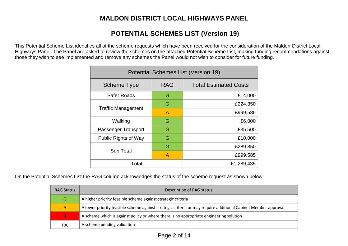
MALDON DISTRICT LOCAL HIGHWAYS PANEL
POTENTIAL SCHEMES LIST (Version 19)
This Potential Scheme List identifies all of the scheme requests which have been received for the consideration of the Maldon District Local Highways Panel. The Panel are asked to review the schemes on the attached Potential Scheme List, making funding recommendations against those they wish to see implemented and remove any schemes the Panel would not wish to consider for future funding.
Potential Schemes List (Version 19)
Scheme Type RAG Total Estimated Costs
Safer Roads G £14,000
Traffic Management G £224,350
A £999,585
Walking G £6,000
Passenger Transport G £35,500
Public Rights of Way G £10,000
Sub Total G £289,850
A £999,585
Total £1,289,435
On the Potential Schemes List the RAG column acknowledges the status of the scheme request as shown below:
RAG Status Description of RAG status
G A higher priority feasible scheme against strategic criteria
A A lower priority feasible scheme against strategic criteria or may require additional Cabinet Member approval
R A scheme which is against policy or where there is no appropriate engineering solution
TBC A scheme pending validation
Page 2 of 14
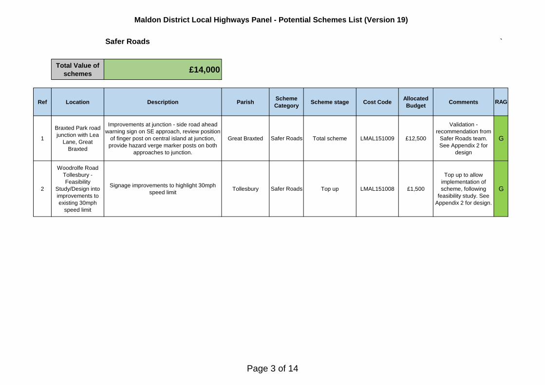
Maldon District Local Highways Panel - Potential Schemes List (Version 19)
Safer Roads `
Total Value of
schemes£14,000
Ref Location Description ParishScheme
CategoryScheme stage Cost Code
Allocated
BudgetComments RAG
1
Braxted Park road
junction with Lea
Lane, Great
Braxted
Improvements at junction - side road ahead
warning sign on SE approach, review position
of finger post on central island at junction,
provide hazard verge marker posts on both
approaches to junction.
Great Braxted Safer Roads Total scheme LMAL151009 £12,500
Validation -
recommendation from
Safer Roads team.
See Appendix 2 for
design
G
2
Woodrolfe Road
Tollesbury -
Feasibility
Study/Design into
improvements to
existing 30mph
speed limit
Signage improvements to highlight 30mph
speed limitTollesbury Safer Roads Top up LMAL151008 £1,500
Top up to allow
implementation of
scheme, following
feasibility study. See
Appendix 2 for design.
G
Page 3 of 14
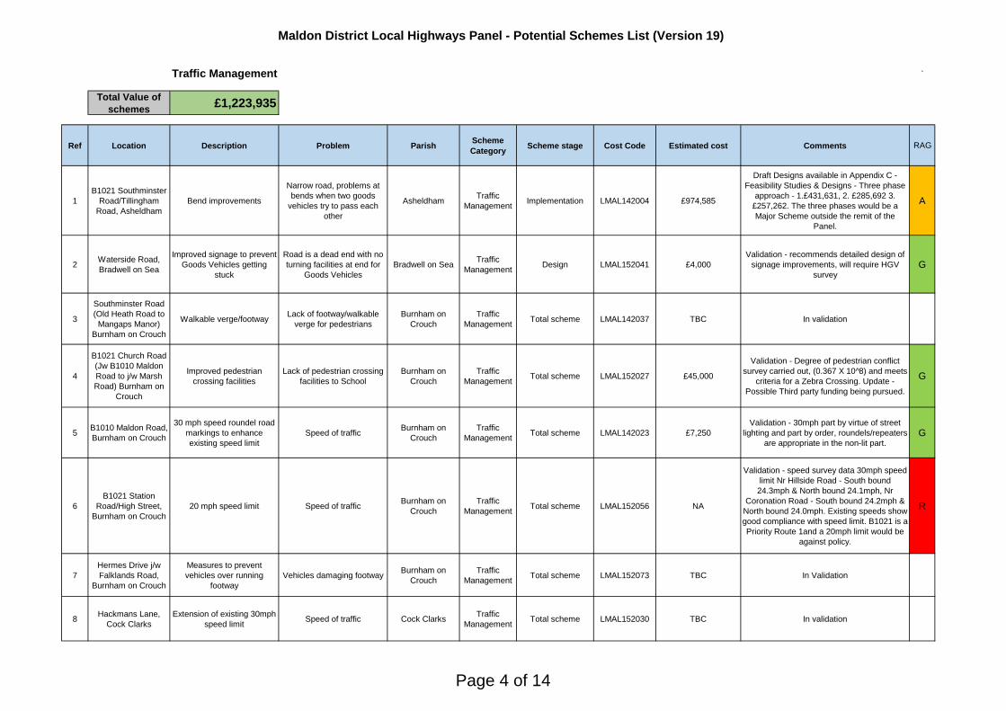
Maldon District Local Highways Panel - Potential Schemes List (Version 19)
`
Total Value of
schemes£1,223,935
Ref Location Description Problem ParishScheme
CategoryScheme stage Cost Code Estimated cost Comments RAG
1
B1021 Southminster
Road/Tillingham
Road, Asheldham
Bend improvements
Narrow road, problems at
bends when two goods
vehicles try to pass each
other
AsheldhamTraffic
ManagementImplementation LMAL142004 £974,585
Draft Designs available in Appendix C -
Feasibility Studies & Designs - Three phase
approach - 1.£431,631, 2. £285,692 3.
£257,262. The three phases would be a
Major Scheme outside the remit of the
Panel.
A
2Waterside Road,
Bradwell on Sea
Improved signage to prevent
Goods Vehicles getting
stuck
Road is a dead end with no
turning facilities at end for
Goods Vehicles
Bradwell on SeaTraffic
ManagementDesign LMAL152041 £4,000
Validation - recommends detailed design of
signage improvements, will require HGV
surveyG
3
Southminster Road
(Old Heath Road to
Mangaps Manor)
Burnham on Crouch
Walkable verge/footwayLack of footway/walkable
verge for pedestrians
Burnham on
Crouch
Traffic
ManagementTotal scheme LMAL142037 TBC In validation
4
B1021 Church Road
(Jw B1010 Maldon
Road to j/w Marsh
Road) Burnham on
Crouch
Improved pedestrian
crossing facilities
Lack of pedestrian crossing
facilities to School
Burnham on
Crouch
Traffic
ManagementTotal scheme LMAL152027 £45,000
Validation - Degree of pedestrian conflict
survey carried out, (0.367 X 10^8) and meets
criteria for a Zebra Crossing. Update -
Possible Third party funding being pursued.
G
5B1010 Maldon Road,
Burnham on Crouch
30 mph speed roundel road
markings to enhance
existing speed limit
Speed of trafficBurnham on
Crouch
Traffic
ManagementTotal scheme LMAL142023 £7,250
Validation - 30mph part by virtue of street
lighting and part by order, roundels/repeaters
are appropriate in the non-lit part. G
6
B1021 Station
Road/High Street,
Burnham on Crouch
20 mph speed limit Speed of trafficBurnham on
Crouch
Traffic
ManagementTotal scheme LMAL152056 NA
Validation - speed survey data 30mph speed
limit Nr Hillside Road - South bound
24.3mph & North bound 24.1mph, Nr
Coronation Road - South bound 24.2mph &
North bound 24.0mph. Existing speeds show
good compliance with speed limit. B1021 is a
Priority Route 1and a 20mph limit would be
against policy.
R
7
Hermes Drive j/w
Falklands Road,
Burnham on Crouch
Measures to prevent
vehicles over running
footway
Vehicles damaging footwayBurnham on
Crouch
Traffic
ManagementTotal scheme LMAL152073 TBC In Validation
8Hackmans Lane,
Cock Clarks
Extension of existing 30mph
speed limitSpeed of traffic Cock Clarks
Traffic
ManagementTotal scheme LMAL152030 TBC In validation
Traffic Management
Page 4 of 14
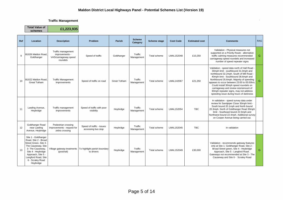
Maldon District Local Highways Panel - Potential Schemes List (Version 19)
`
Total Value of
schemes£1,223,935
Ref Location Description Problem ParishScheme
CategoryScheme stage Cost Code Estimated cost Comments RAG
Traffic Management
9B1026 Maldon Road,
Goldhanger
Traffic management
improvements -
VAS/carriageway speed
roundels
Speed of traffic GoldhangerTraffic
ManagementTotal scheme LMAL152048 £10,250
Validation - Physical measures not
supported on a Priority Route - alternative
traffic calming measures recommended
carriageway speed roundels and increased
number of speed repeater signs
G
10B1022 Maldon Road,
Great Totham
Traffic Management
ImprovementsSpeed of traffic on road Great Totham
Traffic
ManagementTotal scheme LMAL142067 £21,250
Validation - speed data north of Hall Road -
30mph limit - southbound 31.0mph and
northbound 32.2mph. South of Mill Road -
40mph limit - Southbound 36.6mph and
Northbound 35.6mph. Majority of speeding
appears to occur between 23:00 to 05:00hrs.
Could install 30mph speed roundels on
carriageway and review size/amount of
30mph repeater signs, may not address
speeding issue during hours of darkness
G
11Lawling Avenue,
Heybridge
Traffic management
improvements
Speed of traffic with poor
visibilityHeybridge
Traffic
ManagementTotal scheme LMAL152054 TBC
In validation - speed survey data under
review Nr Sandpiper Close 30mph limit -
South bound 20.1mph and North bound
20.3mph. North of Goldhanger Road 30mph
limit - Southeast bound 22.5mph and
Northwest bound 22.4mph. Additional survey
on Cooper Avenue being carried out.
12
Goldhanger Road
near Lawling
Avenue, Heybridge
Pedestrian crossing
improvements - request for
zebra crossing
Speed of traffic - issues
accessing bus stopHeybridge
Traffic
ManagementTotal scheme LMAL152045 TBC In validation
13
Site 1 - Goldhanger
Road, Site 2 - Broad
Street Green, Site 3 -
The Causeway, Site
3- The Causeway,
Site 4 - Heybridge
Approach, Site 5 -
Langford Road, Site
6 - Scraley Road
Heybridge
Village gateway treatments
(post/rail)
To highlight parish boundary
to driversHeybridge
Traffic
ManagementTotal scheme LMAL152049 £30,000
Validation - recommends gateway features
only at Site 1- Goldhanger Road, Site 2 -
Broad Street green, Site 4 - Heybridge
Approach, Site 5 - Langford Road .
Gateways not recommended at Site 3 - The
Causeway and Site 6 - Scraley Road
G
Page 5 of 14
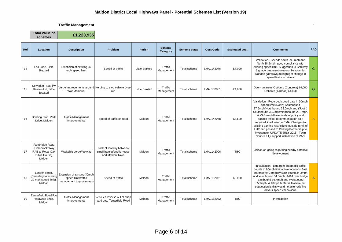
Maldon District Local Highways Panel - Potential Schemes List (Version 19)
`
Total Value of
schemes£1,223,935
Ref Location Description Problem ParishScheme
CategoryScheme stage Cost Code Estimated cost Comments RAG
Traffic Management
14Lea Lane, Little
Braxted
Extension of existing 30
mph speed limitSpeed of traffic Little Braxted
Traffic
ManagementTotal scheme LMAL142076 £7,000
Validation - Speeds south 39.9mph and
North 38.5mph, good compliance with
existing speed limit. Suggestion is Gateway
Signage treatment (may not be room for
wooden gateways) to highlight change in
speed limits to drivers
G
15
Kelvedon Road j/w
Beacon Hill, Little
Braxted
Verge improvements around
War Memorial
Kerbing to stop vehicle over-
runLittle Braxted
Traffic
ManagementTotal scheme LMAL152051 £4,600
Over-run areas Option 1 (Concrete) £4,000
Option 2 (Tarmac) £4,600G
16Bowling Club, Park
Drive, Maldon
Traffic Management
ImprovementsSpeed of traffic on road Maldon
Traffic
ManagementTotal scheme LMAL142078 £8,500
Validation - Recorded speed data in 30mph
speed limit (North) Southbound
27.5mph/Northbound 28.0mph and (South)
Southbound 32.7mph/Northbound 29.7mph.
A VAS would be outside of policy and
against officer recommendation so if
required it will need a CMA. Changes to
existing parking restrictions outside remit of
LHP and passed to Parking Partnership to
investigate. UPDATE JULY 2015 - Town
Council fully support installation of VAS.
A
17
Fambridge Road
(Limebrook Way
RAB to Royal Oak
Public House),
Maldon
Walkable verge/footway
Lack of footway between
small hamlet/public house
and Maldon Town
MaldonTraffic
ManagementTotal scheme LMAL142006 TBC
Liaison on-going regarding nearby potential
development
18
London Road,
(Cemetery to existing
30 mph speed limit),
Maldon
Extension of existing 30mph
speed limit/traffic
management improvements
Speed of traffic MaldonTraffic
ManagementTotal scheme LMAL152031 £8,000
In validation - data from automatic traffic
counts in 60mph limit at two locations East
entrance to Cemetery East bound 34.3mph
and Westbound 34.3mph. A414 over bridge
Eastbound 36.4mph and Westbound
35.9mph. A 40mph buffer is feasible but
suggestion is this would not alter existing
drivers speeds/behaviour.
A
19
Tenterfield Road R/o
Hardware Shop,
Maldon
Traffic Management
Improvements
Vehicles reverse out of shop
yard onto Tenterfield RoadMaldon
Traffic
ManagementTotal scheme LMAL152032 TBC In validation
Page 6 of 14
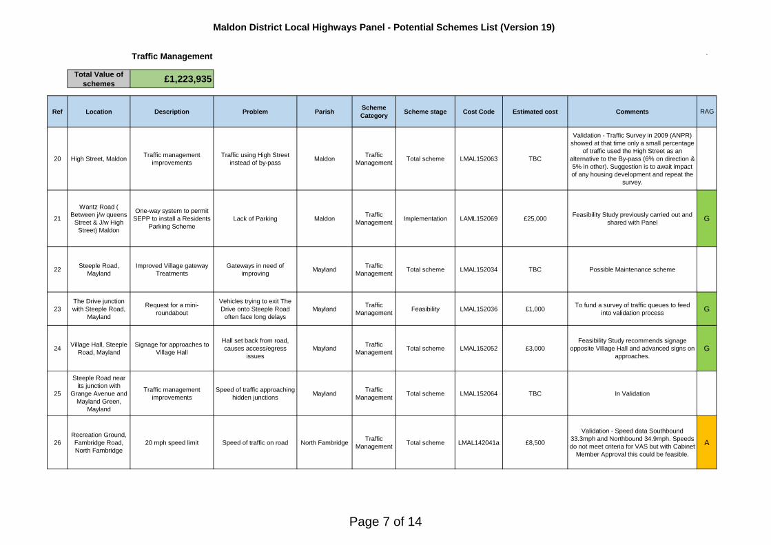
Maldon District Local Highways Panel - Potential Schemes List (Version 19)
`
Total Value of
schemes£1,223,935
Ref Location Description Problem ParishScheme
CategoryScheme stage Cost Code Estimated cost Comments RAG
Traffic Management
20 High Street, MaldonTraffic management
improvements
Traffic using High Street
instead of by-passMaldon
Traffic
ManagementTotal scheme LMAL152063 TBC
Validation - Traffic Survey in 2009 (ANPR)
showed at that time only a small percentage
of traffic used the High Street as an
alternative to the By-pass (6% on direction &
5% in other). Suggestion is to await impact
of any housing development and repeat the
survey.
21
Wantz Road (
Between j/w queens
Street & J/w High
Street) Maldon
One-way system to permit
SEPP to install a Residents
Parking Scheme
Lack of Parking MaldonTraffic
ManagementImplementation LAML152069 £25,000
Feasibility Study previously carried out and
shared with PanelG
22Steeple Road,
Mayland
Improved Village gateway
Treatments
Gateways in need of
improvingMayland
Traffic
ManagementTotal scheme LMAL152034 TBC Possible Maintenance scheme
23
The Drive junction
with Steeple Road,
Mayland
Request for a mini-
roundabout
Vehicles trying to exit The
Drive onto Steeple Road
often face long delays
MaylandTraffic
ManagementFeasibility LMAL152036 £1,000
To fund a survey of traffic queues to feed
into validation processG
24Village Hall, Steeple
Road, Mayland
Signage for approaches to
Village Hall
Hall set back from road,
causes access/egress
issues
MaylandTraffic
ManagementTotal scheme LMAL152052 £3,000
Feasibility Study recommends signage
opposite Village Hall and advanced signs on
approaches.G
25
Steeple Road near
its junction with
Grange Avenue and
Mayland Green,
Mayland
Traffic management
improvements
Speed of traffic approaching
hidden junctionsMayland
Traffic
ManagementTotal scheme LMAL152064 TBC In Validation
26
Recreation Ground,
Fambridge Road,
North Fambridge
20 mph speed limit Speed of traffic on road North FambridgeTraffic
ManagementTotal scheme LMAL142041a £8,500
Validation - Speed data Southbound
33.3mph and Northbound 34.9mph. Speeds
do not meet criteria for VAS but with Cabinet
Member Approval this could be feasible.
A
Page 7 of 14

Maldon District Local Highways Panel - Potential Schemes List (Version 19)
`
Total Value of
schemes£1,223,935
Ref Location Description Problem ParishScheme
CategoryScheme stage Cost Code Estimated cost Comments RAG
Traffic Management
27
Recreation Ground,
Fambridge Road,
North Fambridge
20 mph speed limit Speed of traffic on road North FambridgeTraffic
ManagementTotal scheme LMAL142041b £1,500
Validation - Speed data Southbound
33.3mph and Northbound 34.9mph. Install
Playground warning sign on north bound
approach
G
28
B1010 Fambridge
Road (The Wash to
Roundbush Public
House), Purleigh
Speed reduction measuresNarrow road with passing
places, speed of trafficPurleigh
Traffic
ManagementFeasibility LMAL142031 £3,000
Validation - Feasibility study recommended
into speed reduction measures - possible
extension of 40mph speed limit/existing
passing places and potential for
more/signage review.
G
29
B1018 Fambridge
Road, The Wash
Purleigh to Oak
Corner Maldon
Traffic management
improvements/speed
reduction
Speed of vehicles on B1018 PurleighTraffic
ManagementTotal scheme LMAL152061 TBC In Validation
30
Green
Lanes/Highlands
Hill/Foxhall Road,
Southminster
HGV route signage around
Southminster Lack of HGV route signage Southminster
Traffic
ManagementTotal scheme LMAL152068 £6,000
Scheme to implement signage following
feasibility studyG
31Main Road, St
Lawrence
Traffic management
improvements - speed of
vehicles
Speed of traffic on road St LawrenceTraffic
ManagementTotal scheme LMAL142028 TBC In validation
32 The Street, Steeple30mph repeater signs &
carriageway roundels
Speed of vehicles through
villageSteeple
Traffic
ManagementTotal scheme LMAL152059 NA
Validation - speed limit is by means of Street
Lighting and policy does not allow repeater
roundels. Scheme under LMAL152062 has
merit and should be considered
R
33
The Street, The Sun
& Anchor to The Star
P/H, Steeple
Remove centre white line
and add edge of
carriageway road markings
Narrow section of road SteepleTraffic
ManagementTotal scheme LMAL152062 £2,000
Validation - Carriageway width approximately
7m, sufficient width to install edge of
carriageway markings which would give the
impression of a narrower road. Not
recommended to remove cats eyes as this
could result in significant scarring and
deterioration of the surface. When roads is
resurfaced this would be the time to not
replace the cats eyes.
G
Page 8 of 14

Maldon District Local Highways Panel - Potential Schemes List (Version 19)
`
Total Value of
schemes£1,223,935
Ref Location Description Problem ParishScheme
CategoryScheme stage Cost Code Estimated cost Comments RAG
Traffic Management
34Honey Pot Lane,
Stowe MariesDrainage improvements Drainage issues Stow Maries
Traffic
ManagementTotal scheme LMAL142045 TBC In validation
35
The
Street/Woodham
Road, Stow Maries
Traffic Management
Improvements
Speed of traffic on 30 mph
roadStow Maries
Traffic
ManagementTotal scheme LMAL142065 £12,000
Validation - speed data in 30mph limit - The
Street - Northeast bound - 40.1mph & South
west bound - 41.3mph & Woodham Road -
Northeast bound - 37.3mph & South west
bound - 38.4mph . Recommendation to
install 30mph carriageway roundels to
highlight speed limit and review size/number
of speed limit repeater signs.
G
36
The Street &
Woodham Road,
Stow Maries
Physical traffic calmingSpeed of vehicles following
reduction to 30 mphStow Maries
Traffic
ManagementTotal scheme LMAL152028 See LMAL142065
37Hagg Hill, Stow
Maries
Not suitable for HGV
signageHGV using unsuitable route Stow Maries
Traffic
ManagementTotal scheme LMAL152029 £5,000
Validation - review existing
signage/positioning and install "Unsuitable
for HGV" signageG
38
Church Lane (Nr
Four
Elms/Glebelands),
Stow Maries
Kerbing improvements and
cutting grips to prevent
water ingress onto
properties
Feasibility Study carried out
into measures to address
drainage issues as
properties are at a lower
level to the carriageway
Stow MariesTraffic
ManagementImplementation LMAL152076 £5,000
Option resulting from Feasibility Study, See
Appendix 1G
39North Street/South
Street, Tillingham
Renew all road markings
including centre lines and
bus stops
Road markings faded TillinghamTraffic
ManagementImplementation LMAL152065 NA
Scheme suggestion following feasibility study
into Traffic Management Improvements, this
would be a Maintenance issueR
40
Brook
Road/Tolleshunt
D'Arcy Road,
Tolleshunt Knights
"Kill your Speed" signs
Speed of
traffic/Improvements to
signage
Tolleshunt KnightsTraffic
ManagementTotal scheme LMAL142077 £6,500
Validation - Mean average speed data Brook
Road Westbound 31.7mph, Eastbound
34.6mph. Tolleshunt D'Arcy Road
Southbound 33.9mph, Northbound 32.7mph.
"Kill your speed" signs not a prescribed
highway sign. Recommendation is to
improve speed limit repeater signs and road
markings
G
Page 9 of 14
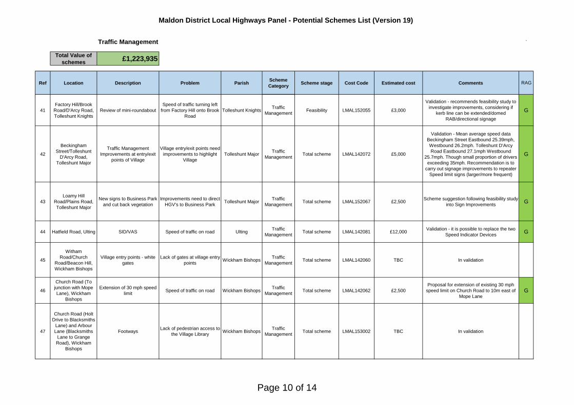
Maldon District Local Highways Panel - Potential Schemes List (Version 19)
`
Total Value of
schemes£1,223,935
Ref Location Description Problem ParishScheme
CategoryScheme stage Cost Code Estimated cost Comments RAG
Traffic Management
41
Factory Hill/Brook
Road/D'Arcy Road,
Tolleshunt Knights
Review of mini-roundabout
Speed of traffic turning left
from Factory Hill onto Brook
Road
Tolleshunt KnightsTraffic
ManagementFeasibility LMAL152055 £3,000
Validation - recommends feasibility study to
investigate improvements, considering if
kerb line can be extended/domed
RAB/directional signage
G
42
Beckingham
Street/Tolleshunt
D'Arcy Road,
Tolleshunt Major
Traffic Management
Improvements at entry/exit
points of Village
Village entry/exit points need
improvements to highlight
Village
Tolleshunt MajorTraffic
ManagementTotal scheme LMAL142072 £5,000
Validation - Mean average speed data
Beckingham Street Eastbound 25.39mph,
Westbound 26.2mph. Tolleshunt D'Arcy
Road Eastbound 27.1mph Westbound
25.7mph. Though small proportion of drivers
exceeding 35mph. Recommendation is to
carry out signage improvements to repeater
Speed limit signs (larger/more frequent)
G
43
Loamy Hill
Road/Plains Road,
Tolleshunt Major
New signs to Business Park
and cut back vegetation
Improvements need to direct
HGV's to Business ParkTolleshunt Major
Traffic
ManagementTotal scheme LMAL152067 £2,500
Scheme suggestion following feasibility study
into Sign ImprovementsG
44 Hatfield Road, Ulting SID/VAS Speed of traffic on road UltingTraffic
ManagementTotal scheme LMAL142081 £12,000
Validation - it is possible to replace the two
Speed Indicator DevicesG
45
Witham
Road/Church
Road/Beacon Hill,
Wickham Bishops
Village entry points - white
gates
Lack of gates at village entry
pointsWickham Bishops
Traffic
ManagementTotal scheme LMAL142060 TBC In validation
46
Church Road (To
junction with Mope
Lane), Wickham
Bishops
Extension of 30 mph speed
limitSpeed of traffic on road Wickham Bishops
Traffic
ManagementTotal scheme LMAL142062 £2,500
Proposal for extension of existing 30 mph
speed limit on Church Road to 10m east of
Mope LaneG
47
Church Road (Holt
Drive to Blacksmiths
Lane) and Arbour
Lane (Blacksmiths
Lane to Grange
Road), Wickham
Bishops
FootwaysLack of pedestrian access to
the Village LibraryWickham Bishops
Traffic
ManagementTotal scheme LMAL153002 TBC In validation
Page 10 of 14
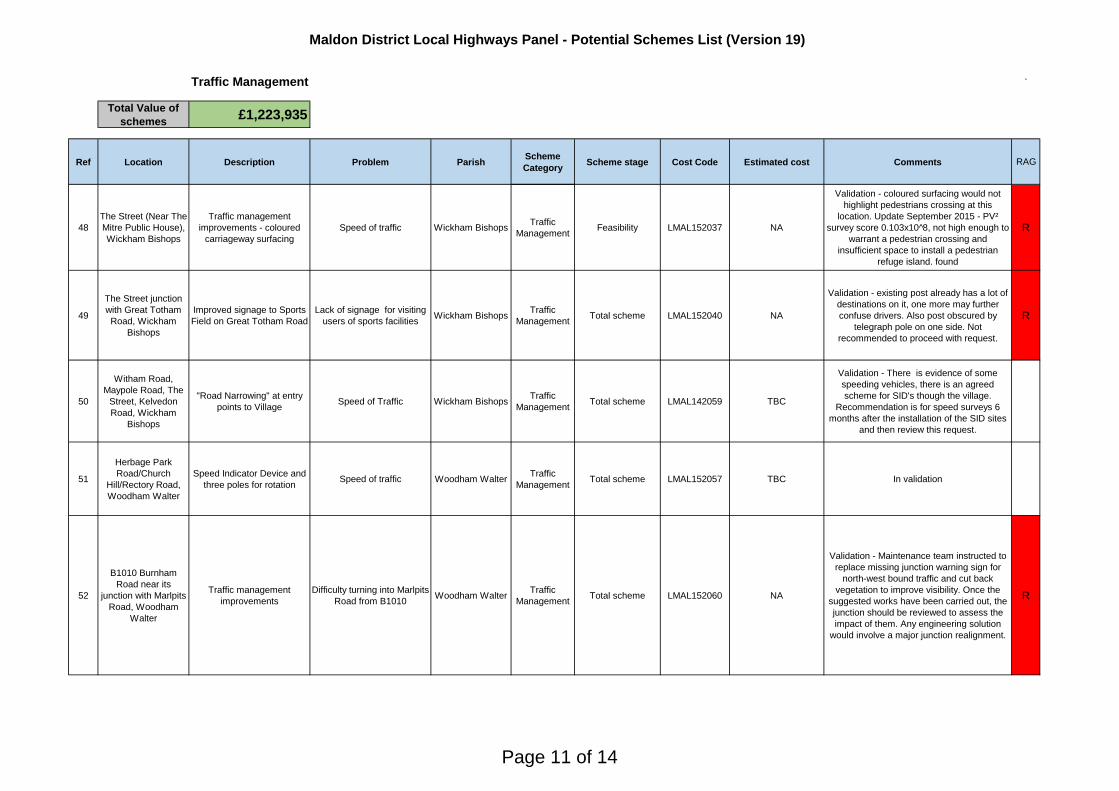
Maldon District Local Highways Panel - Potential Schemes List (Version 19)
`
Total Value of
schemes£1,223,935
Ref Location Description Problem ParishScheme
CategoryScheme stage Cost Code Estimated cost Comments RAG
Traffic Management
48
The Street (Near The
Mitre Public House),
Wickham Bishops
Traffic management
improvements - coloured
carriageway surfacing
Speed of traffic Wickham BishopsTraffic
ManagementFeasibility LMAL152037 NA
Validation - coloured surfacing would not
highlight pedestrians crossing at this
location. Update September 2015 - PV²
survey score 0.103x10^8, not high enough to
warrant a pedestrian crossing and
insufficient space to install a pedestrian
refuge island. found
R
49
The Street junction
with Great Totham
Road, Wickham
Bishops
Improved signage to Sports
Field on Great Totham Road
Lack of signage for visiting
users of sports facilitiesWickham Bishops
Traffic
ManagementTotal scheme LMAL152040 NA
Validation - existing post already has a lot of
destinations on it, one more may further
confuse drivers. Also post obscured by
telegraph pole on one side. Not
recommended to proceed with request.
R
50
Witham Road,
Maypole Road, The
Street, Kelvedon
Road, Wickham
Bishops
"Road Narrowing" at entry
points to VillageSpeed of Traffic Wickham Bishops
Traffic
ManagementTotal scheme LMAL142059 TBC
Validation - There is evidence of some
speeding vehicles, there is an agreed
scheme for SID's though the village.
Recommendation is for speed surveys 6
months after the installation of the SID sites
and then review this request.
51
Herbage Park
Road/Church
Hill/Rectory Road,
Woodham Walter
Speed Indicator Device and
three poles for rotationSpeed of traffic Woodham Walter
Traffic
ManagementTotal scheme LMAL152057 TBC In validation
52
B1010 Burnham
Road near its
junction with Marlpits
Road, Woodham
Walter
Traffic management
improvements
Difficulty turning into Marlpits
Road from B1010Woodham Walter
Traffic
ManagementTotal scheme LMAL152060 NA
Validation - Maintenance team instructed to
replace missing junction warning sign for
north-west bound traffic and cut back
vegetation to improve visibility. Once the
suggested works have been carried out, the
junction should be reviewed to assess the
impact of them. Any engineering solution
would involve a major junction realignment.
R
Page 11 of 14
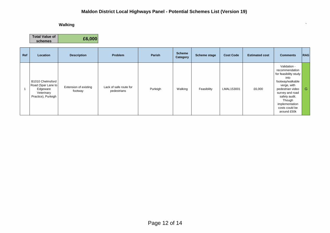
Maldon District Local Highways Panel - Potential Schemes List (Version 19)
Walking `
Total Value of
schemes£6,000
Ref Location Description Problem ParishScheme
CategoryScheme stage Cost Code Estimated cost Comments RAG
1
B1010 Chelmsford
Road (Spar Lane to
Edgeware
Veterinary
Practice), Purleigh
Extension of existing
footway
Lack of safe route for
pedestriansPurleigh Walking Feasibility LMAL153001 £6,000
Validation -
recommendation
for feasibility study
into
footway/walkable
verge, with
pedestrian video
survey and road
safety audit.
Though
implementation
costs could be
around £50k
G
Page 12 of 14
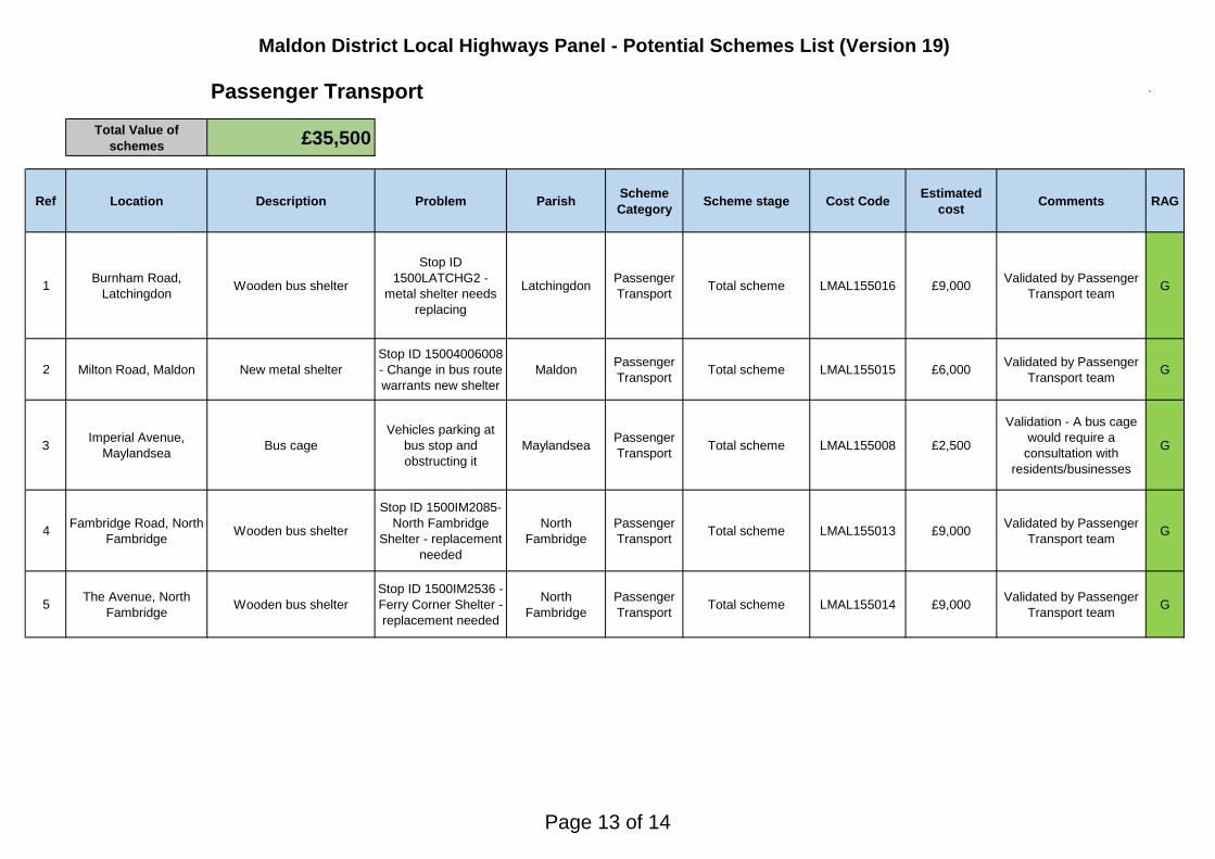
Maldon District Local Highways Panel - Potential Schemes List (Version 19)
Passenger Transport `
Total Value of
schemes £35,500
Ref Location Description Problem ParishScheme
CategoryScheme stage Cost Code
Estimated
costComments RAG
1Burnham Road,
LatchingdonWooden bus shelter
Stop ID
1500LATCHG2 -
metal shelter needs
replacing
LatchingdonPassenger
TransportTotal scheme LMAL155016 £9,000
Validated by Passenger
Transport teamG
2 Milton Road, Maldon New metal shelter
Stop ID 15004006008
- Change in bus route
warrants new shelter
MaldonPassenger
TransportTotal scheme LMAL155015 £6,000
Validated by Passenger
Transport teamG
3Imperial Avenue,
MaylandseaBus cage
Vehicles parking at
bus stop and
obstructing it
MaylandseaPassenger
TransportTotal scheme LMAL155008 £2,500
Validation - A bus cage
would require a
consultation with
residents/businesses
G
4Fambridge Road, North
FambridgeWooden bus shelter
Stop ID 1500IM2085-
North Fambridge
Shelter - replacement
needed
North
Fambridge
Passenger
TransportTotal scheme LMAL155013 £9,000
Validated by Passenger
Transport teamG
5The Avenue, North
FambridgeWooden bus shelter
Stop ID 1500IM2536 -
Ferry Corner Shelter -
replacement needed
North
Fambridge
Passenger
TransportTotal scheme LMAL155014 £9,000
Validated by Passenger
Transport teamG
Page 13 of 14

Maldon District Local Highways Panel - Potential Schemes List (Version 19)
Public Rights of Way `
Total Value of
schemes£10,000
Ref Location Description Problem ParishScheme
CategoryScheme stage Cost Code Estimated cost Comments RAG
1
Footpath 36 (over
railway , off
Foundry Lane),
Burnham on
Crouch
Surface improvements -
resurfacing 48 sqm
Footpath is in an urban
area and is well used -
surface worn/uneven,
puddles form after rainfall
Burnham on
Crouch
Public
Rights of
Way
Total Scheme LMAL158005 £6,000Validated by PRoW
teamG
2
Footpath FP4
(Kelvedon to Goat
Lodge Roads),
Great Totham
Surface improvements,
planings/timber edging for
200m
Footpath needs surface
improvementsGreat Totham
Public
Rights of
Way
Total scheme LMAL158004 £4,000Validated by PRoW
teamG
3
Handley's Lane,
between Kelvedon
Road and
Handley's Lane
roadway, Wickham
Bishops
Surface improvements to
byway to allow all round year
usage
Byway often inaccessible
due to flooding /surface
condition
Wickham Bishops
Public
Rights of
Way
Total scheme LMAL158003 TBC In validation
Page 14 of 14
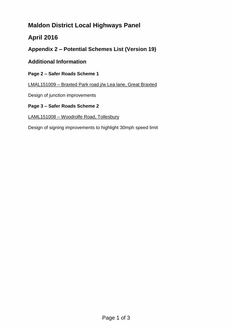
Maldon District Local Highways Panel
April 2016
Appendix 2 – Potential Schemes List (Version 19) Additional Information Page 2 – Safer Roads Scheme 1 LMAL151009 – Braxted Park road j/w Lea lane, Great Braxted Design of junction improvements Page 3 – Safer Roads Scheme 2 LAML151008 – Woodrolfe Road, Tollesbury Design of signing improvements to highlight 30mph speed limit
Page 1 of 3
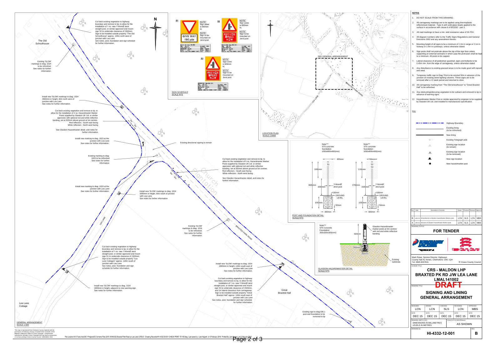
L
E
A
L
A
N
E
SEE GENERAL ARRANGEMENT
B
R
A
X
T
E
D
P
A
R
K
R
O
A
D
TP
G
L
E
A
L
A
N
E
Cut back existing vegetation to highway
boundary and remove to tip, to allow for the
installation of 1 no. new 114mmØ Jerol
straight post, or similar approved and mount
sign S2 to underside clearance of 1500mm.
Sign to be installed outside property "The Old
Schoolhouse" approx. 126m north west of
junction with Lea Lane
See notes, post, foundation and sign schedule
for further information.
Cut back existing vegetation to highway
boundary and remove to tip, to allow for the
installation of 1 no. new 114mmØ Jerol
straight post, or similar approved and mount
sign S3 to underside clearance of 1500mm,
and 1m lateral clearance from carriageway.
Sign to be installed outside property "Great
Braxted Hall" approx. 140m south east of
junction with Lea Lane
See notes, post, foundation and sign schedule
for further information.
Install new 'SLOW' markings to diag. 1024
2800mm in height, 40m north west of
junction with Lea Lane
See notes for further information.
Existing 'SLOW'
markings to diag. 1024
to be refreshed.
See notes for further
information.
Existing 'SLOW'
markings to diag. 1024
to be refreshed.
See notes for further
information.
Install new 'SLOW' markings to diag. 1024
2800mm in height, 140m south east of
junction with Lea Lane
See notes for further information.
Install new marking to diag. 1023 at the
junction with Lea Lane
See notes for further information.
The Old
Schoolhouse
Lea Lane
Cottage
Great
Braxted Hall
Install new marking to diag. 1023 at the
junction with Lea Lane
See notes for further information. Install new 'SLOW' markings to diag. 1024
1600mm in height, 50m south of junction
with Lea Lane
See notes for further information.
Install new 'SLOW' markings to diag. 1024
1600mm in height, adjacent to new warning sign.
See notes for further information.
TP
TP
TP
TP
Existing sign to diag.506.1
post and foundation to be
removed to tip
Cut back existing vegetation to highway
boundary and remove to tip, to allow for the
installation of 1 no. new 114mmØ Jerol
straight post, or similar approved and mount
sign S1 to underside clearance of 1500mm.
Sign to be installed outside property "Lea
Lane Cottages" approx. 140m south of
junction with Lea Lane
See notes, post, foundation and sign
schedule for further information.
Existing directional signing to remain
Existing marking to diag.
1023 to be refreshed
See notes for further
information.
B
R
A
X
T
E
D
P
A
R
K
R
O
A
D
Cut back existing vegetation and remove to tip, to
allow for the installation of 5 no. Hazardmaster Marker
Posts supplied by Glasdon UK Ltd. or similar
approved, with optional red and white reflective
banding, set at 920mm above ground at 5m centres.
Red reflectors - South east facing
White reflectors - North west facing
See Glasdon Hazardmaster detail, and notes for
further information.
5
m
5
m
5
m
5
m
Cut back existing vegetation and remove to tip, to
allow for the installation of 3 no. Hazardmaster Marker
Posts supplied by Glasdon UK Ltd. or similar
approved, with optional red and white reflective
banding, set at 920mm above ground at 5m centres.
Red reflectors - South east facing
White reflectors - North west facing
See Glasdon Hazardmaster detail, and notes for
further information.
855mm
1095mm
1500mm
114mmØ
Jerol post
100mm
50mm
1050mm
800mm
Note***
ST5 concrete
foundation
1050x800x400(mm)
3695mm
GROUND
LEVEL
S1
740mm
1190mm
1500mm
114mmØ
Jerol post
100mm
50mm
1050mm
800mm
Note***
ST5 concrete
foundation
1050x800x400(mm)
3790mm
GROUND
LEVEL
S2
S3
NOTE*
Sign sizes
is 600mm
ht.
NOTE*
Sign to be
mounted on
Jerol post
Glasdon Hazardmaster
marker posts at 5m centres
with red and white reflective
banding
Note***
ST5 Concrete
Foundation
350x300x300(mm)
Existing
substrata
350mm
300mm
920mm
This map is reproduced from Ordnance Survey material with the
permission of Ordnance Survey on behalf of the Controller of Her
Majesty’s Stationery Office © Crown Copyright. Unauthorised
reproduction infringes Crown Copyright and may lead to prosecution
or civil proceedings. Essex County Council, 100019602, 2015
HI-4332-12-001
SIGNING AND LINING
GENERAL ARRANGEMENT
CRS - MALDON LHP
BRAXTED PK RD J/W LEA LANE
LMAL141002
B
DESIGNED
DATE
DRAWN
DATE
CHECKED
DATE
APPROVED
DATE
DRAWING TITLE
SCHEME TITLE
DRAWING No. REV.
DRAWING UNITS U.N.O. SCALE AT A1 (841X594mm)
DIMENSIONS IN MILLIMETRES
LEVELS IN METRES
DRAWING STATUS
FOR TENDER
AS SHOWN
Mark Rowe, Service Director, Highways
County Hall A2 Annex, Chelmsford. CM1 1QH
Tel: 0845 6037631 © Essex County Council
LCN
DEC 15
LCN SLS MBS
REVIEWED
DATE
LCN
Rev. Date Description of revision Drawn Checked Review'd Approv'd
A
JAN 16Inclusion of Glasdon Hazardmaster Marker posts
LCN SLS LCN MBS
NOTES
1. DO NOT SCALE FROM THIS DRAWING.
2. All carriageway markings are to be applied using thermoplastic
reflectorised material - Type A with solid glass beads applied to the
surface in accordance with clause 6 of BS3262 : part 3.
3. All road markings to have a min. skid resistance value of 55 PSV.
4. All diagram numbers refer to the Traffic Signs Regulations and General
Directions 2002 and any amendment thereto.
5. Mounting height of all signs to be a minimum of 1.2m in verge or 2.1m in
footway or 2.4m in cycleways, unless otherwise stated.
6. Sign posts shall not protrude above the top of the sign face unless
supporting an external luminaire in which case the protrusion shall be kept
to a minimum. All posts to be capped.
7. Lateral clearance of all pedestrian guardrail, signs and bollards to be
0.45m min. from the edge of carriageway, unless otherwise stated.
8. Any disturbance to existing grassed areas is to be made good with topsoil
and seed.
9. Temporary traffic sign to Diag 7014 to be erected 50m in advance of the
junction on existing street lighting columns. These signs are to be
removed after a 12 week period and returned to store.
10. All carriageway marking from "The Old Schoolhouse" to "Great Braxted
Hall" to be refreshed.
11. Any obstructing/obscuring vegetation to be cutback and removed to tip in
advance of warning signs.
12. Hazardmaster Marker Post or similar approved by engineer to be supplied
by Glasdon UK Ltd, and installed to manufactures specification.
Key
Highway Boundary
Existing lining
(to be refreshed)
New lining
Existing Telegraph pole
Existing sign location
(to remain)
Existing sign location
(to be removed)
New sign location
New hazardmarker post
N
N
LOCATION PLAN
SCALE 1:5000
POST AND FOUNDATION DETAIL
SCALE NTS
GENERAL ARRANGEMENT
SCALE 1:500
SIGN SCHEDULE
SCALE NTS
TP
DEC 15 DEC 15 DEC 15 DEC 15
GLASDON HAZARDMASTER DETAIL
SCALE NTS
B
JAN 16Amendments to Glasdon Hazardmaster Marker posts
LCN SLS LCN MBS
DRAFT
Page 2 of 3
2 x S1 back to back facing
oncoming traffic mounted
beneath existing road
liable to flooding warning
sign and plate
Existing TP (end of
street lit section to west)
2 x S1 mounted back to
back at 1.2m on new post
erected in verge 0.7m to
rear of footway
Existing TP (street
lit)
2 x S1 mounted back to
back at 2.1m in verge to
rear of footway
G
9.0m
5.2m
Entrance to recycling
centre
E
a
st S
tre
e
t
TOLLESBURY
M
e
l
l
R
o
a
d
Crescent R
oad
T
h
u
r
s
t
a
b
le
R
o
a
d
W
o
o
d
r
o
lfe
R
o
a
d
Tollesbury
Marina
S1
HI-4198-00-001 -
DESIGNED
DATE
DRAWN
DATE
CHECKED
DATE
APPROVED
DATE
DRAWING No. REV.
DRAWING UNITS U.N.O. SCALE AT A3 (420x297mm)
DIMENSIONS IN MILLIMETRES
LEVELS IN METRES
DRAWING STATUS
SLS
19JAN16
SLS
19JAN16
PN
19JAN16 19JAN16
As Shown
This map is reproduced from Ordnance Survey material with the
permission of Ordnance Survey on behalf of the Controller of Her
Majesty’s Stationery Office © Crown Copyright. Unauthorised
reproduction infringes Crown Copyright and may lead to prosecution or
civil proceedings. Essex County Council, 100019602, 2015
GENERAL ARRANGEMENT
WOODROLFE ROAD, TOLLESBURY
SPEED LIMIT FEASIBILITY STUDY
LMAL151008
DRAWING TITLE
SCHEME TITLE
Mark Rowe, Service Director, Highways
County Hall A2 Annex, Chelmsford. CM1 1QH
Tel: 0845 6037631 © Essex County Council
DETAILED DESIGN
REVIEWED
DATE
SLS
19JAN16
Notes
1. Do not scale.
N
MBS
Key
Area of interest
Proposed sign and post
Existing gulley
Rev. Date Description of revision Drawn Checked Review'd Approv'd
Sign Schedule
NTS
Signage - Notes
1. Foundations to be 600mm x 600mm x 600mm
ST5 concrete with 150mm cover.
2. Diagram 670-30 repeater signs mounted back
to back on 76mm post.
3. Sign posts shall not protrude above the top of
the sign face and should be capped.
4. Location of proposed signs to be marked out on
site by Engineer prior to works.
Location Plan
Scale 1:10,000
Inset 1
Scale 1:1,000
Inset 2
Scale 1:1,000
G
Page 3 of 3
Job Ref. Date Parish Location Street WorksDate
Completed
Requested
by
836 07/12/15 North Fambridge Adjacent to Byfleet House Fambridge Road Plainings/top soil to eroded verge 16/12/15 ECC
837 07/12/15 Maldon Near 1 Midguard Way Strim/cut back vegetation 16/12/15 ECC
838 09/12/15 Maldon O/s 4 & near 7 St Marys Lane Clear out gullies 15/12/15 ECC
Maldon Strim/cut back vegetation 08-11/12/2015 MDC
Latchingdon Latchingdon Rectory Lane Cut up/remove tree 15/12/15 MDC
Mayland Mayland Steeple Road Strim/cut back vegetation 15/12/15 MDC
Southminster Play area Southfields Strim/cut back vegetation 17/12/15 MDC
Mundon/Woodham Walter Strim/cut back vegetation 22/12/15 MDC
Southminster Street furniture maintenance 23/12/15 MDC
Maldon Cut up/remove tree 29/12/15 MDC
Heybridge Sign maintenance 31/12/15 MDC
Maldon Strim/cut back vegetation 31/12/15 MDC
839 13/01/16 Southminster Lamp column 48 - no.7 Hall Road Strim/cut back vegetation 18/01/16 ECC
Maldon Promenade Park Park Drive Cut up/remove tree 19/01/16 MDC
Heybridge Heybridge Drapers Chase Street furniture maintenance 19/01/16 MDC
823 14/10/15 HeybridgeBetween Ash Grove/ Wood
Road Broad Street Green Clear debris from ditch 20/01/16 ECC
Southminster Southminster High Street Street furniture maintenance 21/01/16 MDC
Mundon VariousFambridge Rd, Lower Burnham Rd, The Endway
to Tinkers Hole, Rectory LaneStreet furniture maintenance 22/01/16 MDC
Maldon Promenade Park Park Drive Cut up/remove tree 26-27/01/16 MDC
01/02/16 01/02/2016 MDCTraining Course
Blind Lane/Oak farm Road
New Moor Crescent to Station Road
Downs Road to Chandler's Quay
A414 to B1018
Stock Chase
MDC341
MDC342
MDC343
Maldon District Highway Rangers Works Summary - February 2016
Footpath Essex Road to Morrison, Morrison to Wycke HillMDC324
MDC325
MDC326
MDC327
MDC328
MDC329
MDC330
MDC331
MDC332
MDC339
MDC340
Page 1 of 3
Maldon District Local Highways Panel - Highway Rangers Works Summary
Job Ref. Date Parish Location Street WorksDate
Completed
Requested
by
Maldon District Highway Rangers Works Summary - February 2016
Burnham Burnham On Crouch Junction of Coronation Rd & Station Rd BOC Street furniture maintenance 28/01/16 MDC
Maldon Street furniture maintenance 29/01/16 MDC
841 27/01/16 Heybridge O/S HE Hill + 50m /No.5 The Square/ Heybridge Street roundabout Clear out channel/gully 29/01/16 ECC
Burnham Sign maintenance 02/02/16 MDC
840 20/01/16 Mayland Side of No.1 Tern Close Strim/cut back vegetation 03/02/16 ECC
Various Sign maintenance 05/02/16 MDC
Heybridge Cemetery Goldhanger Road Strim/cut back vegetation 05/02/16 MDC
Maldon Iceland's Car Park White Horse Lane Strim/cut back vegetation 10/02/16 MDC
843 09/02/16 Maldon Outside no.68 Takeaway Mill Road Strim/cut back vegetation 12/02/16 ECC
844 11/02/16 MaldonO/S no.40 near J W Bates
RdThe Causeway Clean out footway gully 15/02/16 ECC
845 11/02/16 Maldon O/S no.7 S/W Mill Lane Fullbridge Clean out footway gully 15/02/16 ECC
846 11/02/16 Heybridge O/S Residential Home The Street Clean out footway gully 15/02/16 ECC
Maldon Street furniture maintenance 16/02/16 MDC
Maldon Street furniture maintenance 16/02/16 MDC
Fambridge Street furniture maintenance 17/02/16 MDC
Maldon Cut up/remove tree 17/02/16 MDC
Fambridge Sign cleaning 18/02/16 MDC
Heybridge Strim/cut back vegetation 19/02/16 MDC
Langford Sign cleaning 22/02/16 MDC
Maldon Street furniture maintenance 23/02/16 MDC
Heybridge Sign/Post maintenance 24/02/16 MDC
Maldon
Bergen Court
Fairway Drive
A414
Beeleigh Rd, Fambridge Rd
Fambridge Road
Beeleigh Road
Harvest Way
Fambridge Road/Lower Burnham Road/End Way/Rectory Lane
Ferry Road to Lower Burnham Road
Scraley Road
MDC354
MDC355
MDC356
MDC358
MDC346
MDC347
MDC348
MDC359
MDC349
MDC350
MDC351
MDC352
MDC353
MDC344
MDC345
Whole of Parish
Page 2 of 3
Maldon District Local Highways Panel - Highway Rangers Works Summary

Job Ref. Date Parish Location Street WorksDate
Completed
Requested
by
Maldon District Highway Rangers Works Summary - February 2016
Heybridge Sign/Post maintenance 24-25 /02/2016 MDC
Maldon Promenade Park Dump Road Sign/Post maintenance 26/02/16 MDC
Key
MDC - Maldon District Council TC/PC - Town/Parish Council
MDC360
MDC361
Whole of Parish
ECC - Essex County Council/Essex Highways
Page 3 of 3
Maldon District Local Highways Panel - Highway Rangers Works Summary