Maintenance Dredging and Spoil Disposal …...Maintenance Dredging and Spoil Disposal Management...
170
Transcript of Maintenance Dredging and Spoil Disposal …...Maintenance Dredging and Spoil Disposal Management...


Maintenance Dredging and Spoil Disposal Management Plan
Document no.: L060-AH-PLN-60010 ii
Security Classification: Restricted Revision: 1 Date: 16 March 2018
Document distribution
Copy no.
Name Hard
copy
Electronic
copy
00 Document control
01 Department of Infrastructure, Planning and Logistics
02 Northern Territory Environment Protection Authority
03 Department of the Environment and Energy
04 Conor Walker
05 Atsushi Sakamoto
06 Craig Haymes
07 Bruce Macgregor
08 Thijs van Berkel
09 Sandy Griffin
10 Jamie Carle
11 Sean Kildare
12 David Gwyther
13 Bruce Anderson
14 Maris Steele
15 Rebecca Cass
16 Mark Wilson
17 Glen Bajars
18 Dave Dann
19 Lance Kenny
20 Jake Tobin

Maintenance Dredging and Spoil Disposal Management Plan
Document no.: L060-AH-PLN-60010 iii
Security Classification: Restricted Revision: 1 Date: 16 March 2018
Notice
All information contained with this document has been classified by INPEX as Restricted
and must only be used in accordance with that classification. Any use contrary to this
document's classification may expose the recipient and subsequent user(s) to legal
action. If you are unsure of restrictions on use imposed by the classification of this
document you must refer to the INPEX Sensitive Information Protection Standard or seek
clarification from INPEX.
Uncontrolled when printed.

Maintenance Dredging and Spoil Disposal Management Plan
Document no.: L060-AH-PLN-60010 iv
Security Classification: Restricted Revision: 1 Date: 16 March 2018
Table of contents
1 INTRODUCTION 1
1.1 Purpose 1
1.2 Scope 2
1.3 Proponent 2
1.4 Independent expert review 3
1.5 Interface other INPEX and Dredging Contractor documents 3
1.6 Review and revision of this Plan 4
2 LEGISLATIVE FRAMEWORK 5
2.1 Ichthys Project environmental approval 5
2.2 Maintenance dredging approvals 5
2.3 Relevant conventions, legislation, standards and guidelines 6
2.3.1 International conventions, agreements and guidelines 6
2.3.2 Commonwealth and Northern Territory legislation, standards and guidelines 6
3 MAINTENANCE DREDGING AND SPOIL DISPOSAL ACTIVITY 10
3.1 Maintenance dredging campaigns 10
3.2 Work locations 10
3.2.1 Dredge area 10
3.2.2 Dredge spoil disposal area 11
3.3 Work method and rationale 12
3.3.1 Equipment selection 13
3.3.2 Dredging method 14
3.3.3 Spoil disposal method 15
3.4 Seabed leveller 16
4 DESCRIPTION OF THE ENVIRONMENT 17
4.1 Physical environment 17
4.1.1 Climate 17
4.1.2 Bathymetry and seafloor geology 19
4.1.3 Oceanography 19
4.1.4 Water quality 21
4.1.5 Sediment quality 24
4.1.6 Underwater noise 26
4.2 Marine benthic habitats 27
4.2.1 Mangroves 29
4.2.2 Coral 30
4.2.3 Seagrass 32
4.2.4 Macroalgae 33
4.2.5 Soft-bottom benthos 33
4.3 Pelagic environment 34
4.3.1 Marine mammals 34

Maintenance Dredging and Spoil Disposal Management Plan
Document no.: L060-AH-PLN-60010 v
Security Classification: Restricted Revision: 1 Date: 16 March 2018
4.3.2 Marine reptiles 35
4.3.3 Fish and sharks 36
4.3.4 Phytoplankton 37
4.4 Parks and reserves 38
4.5 Cultural environment 39
4.5.1 Aboriginal sacred sites 39
4.5.2 Non-Aboriginal heritage sites 39
4.6 Social and economic environment 40
4.6.1 Beneficial uses 40
4.6.2 Darwin Port operations 41
4.6.3 Tourism 41
4.6.4 Commercial fishing and aquaculture 41
4.6.5 Recreational and traditional fishing 41
5 ENVIRONMENTAL RISK ASSESSMENT 43
5.1 Conceptual site model 43
5.2 Summary of risk assessment outcomes 46
5.3 ALARP Justification 53
5.3.1 Sediment-related impacts 53
5.3.2 Underwater noise 57
5.3.3 Unexploded ordnance (UXO) and heritage objects 59
5.4 Assessment of potential for cumulative impacts 59
5.4.1 Sequential Project-related maintenance dredging campaigns 59
5.4.2 Concurrent Harbour-wide dredging campaigns 61
5.4.3 Long-term effects on East Arm sediment balance 61
6 SEDIMENT PLUME MODELLING AND IMPACT ASSESSMENT 63
6.1 Maintenance dredging scenario 63
6.2 Synthesis of modelling assessment approach 64
6.3 Hydrodynamic model 64
6.3.1 General description 64
6.3.2 Data inputs 66
6.4 Sediment transport model 66
6.4.1 General description 66
6.4.2 Data inputs 66
6.5 Model outputs 68
6.5.1 Excess SSC maps 68
6.5.2 Sediment deposition maps 73
6.6 Tolerance limits for habitats 75
6.6.1 SSC tolerance limits 75
6.6.2 Sedimentation tolerance limits 76
6.7 Habitat impact assessment analysis 77

Maintenance Dredging and Spoil Disposal Management Plan
Document no.: L060-AH-PLN-60010 vi
Security Classification: Restricted Revision: 1 Date: 16 March 2018
6.8 Habitat impact assessment outcomes 78
7 ENVIRONMENTAL MANAGEMENT 83
7.1 Management of sediment-related effects 83
7.1.1 Sediment-related effects management framework 85
7.1.2 Development of reactive management triggers 87
7.1.3 Attributability investigation 88
7.1.4 Responsive management 89
7.1.5 Contingency management 90
7.2 Management of other dredging aspects 90
7.2.1 Introduced marine pests management framework 91
7.2.2 Dredge materials management framework 94
7.2.3 Protected marine megafauna management frameworks 95
7.2.4 Heritage and sacred site management framework 100
7.2.5 Waste and liquid discharges management framework 103
7.2.6 Hydrocarbon and chemical management and spill response framework 105
8 WATER QUALITY MONITORING 108
8.1 Objectives 108
8.2 Development of risk-based water quality monitoring program 108
8.3 Monitoring sites 109
8.4 Methods 111
8.4.1 Data collection 111
8.4.2 Parameters 112
8.4.3 Quality control and assurance 112
8.4.4 Data analysis 113
8.5 Remote sensing 114
9 STAKEHOLDER ENGAGEMENT AND COMMUNICATIONS 115
9.1 Timing 115
9.2 Stakeholders 115
9.3 Engagement tools 115
10 ENVIRONMENTAL MANAGEMENT IMPLEMENTATION STRATEGY 116
10.1 INPEX HSEQ-MS 116
10.2 Dredging contractor HSEQ-MS 117
10.3 Emergency response 117
10.4 Roles and responsibilities 117
10.5 Inductions and training 119
10.5.1 HSEQ inductions 119
10.5.2 MMO training 119
10.6 Inspections and audits 119
10.6.1 Internal audits 119
10.6.2 External audits 120

Maintenance Dredging and Spoil Disposal Management Plan
Document no.: L060-AH-PLN-60010 vii
Security Classification: Restricted Revision: 1 Date: 16 March 2018
10.7 Internal reporting 120
10.7.1 Routine reporting 121
10.7.2 Environmental event reporting and investigation 121
10.8 External reporting 121
10.8.1 Exceedance reporting 121
10.8.2 Routine monitoring reporting 122
10.8.3 Environmental incident and non-compliance reporting 122
10.8.4 Other external reporting/notification requirements 123
10.9 Data and records management 123
10.10 Management of change 124
11 REFERENCES 125
List of Tables
Table 1-1: Independent experts consulted in the development of this Maintenance
DSDMP 3
Table 2-1: International conventions, agreements and guidelines 6
Table 2-2: Commonwealth legislation, standards and guidelines 7
Table 2-3: Northern Territory legislation, standards, plans and guidelines 8
Table 4-1: Average monthly rainfall for Darwin (measured as mm) 17
Table 4-2: Hard coral composition (%) in the final post dredging survey (Cardno 2015c)31
Table 4-3: Conservation status of marine mammals, which may occur within the Darwin
region 35
Table 4-4: Conservation status of marine reptiles, which may occur within the Darwin
region 36
Table 4-5: Protected marine sharks which may be present in Darwin Harbour 37
Table 4-6: Darwin Harbour parks and reserves 38
Table 4-7: AAPA Authority Certificates relevant to maintenance dredging activities 39
Table 5-1: Summary of risk assessment outcomes 49
Table 5-2: Overview of anthropogenic noise sources 57
Table 6-1: Overview of modelling aspects for the worst-case credible scenario 63
Table 6-2: Assumed primary and secondary losses of fines during dredging, loading and
disposal 67
Table 6-3: Tolerance limits for excess SSC and sedimentation 75
Table 6-4: Simulated areas of impact based on highest intensity period (SN2; days 15 to
29) of the worst-case credible scenario 78
Table 7-1: Environmental objectives, targets and indicators template 83
Table 7-2: Environmental management framework template 83
Table 7-3: Sediment-related effects management framework 85
Table 7-4: Level 1 and 2 turbidity management trigger criteria for sediment-related
effects 87
Table 7-5: Responsive management practices as adapted from the PIANC 100 Report
(Netzband et al. 2009) 89
Table 7-6: Contingency management practices as adapted from the PIANC 100 Report
(Netzband et al. 2009) 90

Maintenance Dredging and Spoil Disposal Management Plan
Document no.: L060-AH-PLN-60010 viii
Security Classification: Restricted Revision: 1 Date: 16 March 2018
Table 7-7: Introduced marine pest objectives, targets and indicators 91
Table 7-8: Introduced marine pest management framework 91
Table 7-9: Dredge materials objectives, targets and indicators 94
Table 7-10: Dredge materials management framework 95
Table 7-11: Protected marine megafauna—whale, dolphin, dugong and turtle interaction
objectives, targets and indicators 96
Table 7-12: Protected marine megafauna—whale, dolphin, dugong and turtle interaction
management framework 96
Table 7-13: Protected marine megafauna—marine turtle and sawfish entrainment
objectives, targets and indicators 99
Table 7-14: Protected marine megafauna—marine turtle and sawfish entrainment
management framework 99
Table 7-15: Heritage and sacred site objectives, targets and indicators 100
Table 7-16: Heritage and sacred site management framework 100
Table 7-17: Waste and liquid discharges objectives, targets and indicators 103
Table 7-18: Waste and liquid discharges management framework 103
Table 7-19: Hydrocarbon and chemical management and spill response objectives,
targets and indicators 105
Table 7-20: Hydrocarbon and chemicals management and spill response framework 106
Table 8-1: Decision tree water quality locations. 'R' = reactive, 'I' = informative 111
Table 8-2: Proposed water quality parameters and units 112
Table 10-1: Summary of key environmental roles and responsibilities 117
Table 10-2: Audits and inspections 120
Table 10-3: Reactive monitoring exceedance notification and reporting summary 121
Table 10-4: External reporting—incident and non-compliance 122
Table 10-5: External reporting—other 123
Table 11-1: Protection zone types and requirements 149
Table 11-2: Heritage wreck sites and protection zones relevant to vessels operating
under this Maintenance DSDMP 150
List of Figures
Figure 1-1: Interface documents 4
Figure 3-1: Dredge area 11
Figure 3-2: Location of the DSDA 12
Figure 3-3: Overflow fitted with green valve 15
Figure 4-1: February (indicative wet season) and August (indicative dry season) wind
roses for Darwin Airport based on data from 1942 to 2016 (BOM 2016d) 18
Figure 4-2: Bathymetry of Darwin Harbour 19
Figure 4-3: Modelled peak current speeds for each tidal state 20
Figure 4-4: Key oceanographic processes that affect turbidity in Darwin Harbour and the
Beagle Gulf (Cardno 2014b) 22
Figure 4-5: Composite MODIS imagery for September (2008-2012) spring tide (top) and
neap tide (bottom) periods 23
Figure 4-6:Benthic habitat map of the greater Darwin region 28
Figure 4-7: Benthic habitat map of Darwin Harbour 29

Maintenance Dredging and Spoil Disposal Management Plan
Document no.: L060-AH-PLN-60010 ix
Security Classification: Restricted Revision: 1 Date: 16 March 2018
Figure 4-8: Major mangrove assemblages of Darwin Harbour and their position in the
tidal profile (adapted from Brockelhurst and Edmeades 1996) (Cardno 2014b)30
Figure 4-9: Temporal and spatial dynamics of Halodule uninervis and Halophila decipiens
seagrass habitat in Darwin found through the capital dredging program
(Cardno 2014b) 33
Figure 4-10: Shipwrecks and sunken aircraft in Darwin Harbour 40
Figure 5-1: Maintenance dredging conceptual site model 44
Figure 5-2 Conceptual site model related to the natural (top) and dredging derived
(bottom) turbidity and sedimentation on sensitive receptors (Cardno 2014b)45
Figure 5-3: INPEX Environmental consequence table 47
Figure 5-4: INPEX Risk Matrix 48
Figure 5-5: TSHD sound sources (CEDA 2011) 58
Figure 5-6: Darwin airport monthly average rainfall (mm ±SE) and number of cyclone
formation per month between 1964 and 2015 60
Figure 6-1: Synthesis of modelling assessment approach 64
Figure 6-2: Model extent and mesh resolution of the revised hydrodynamic model and
sediment transport model 65
Figure 6-3: Visual representations of the source terms for fine sediment released into the
environment during dredging and spoil disposal activities 67
Figure 6-4: Worst-case credible scenario model results representing the 50th percentile
excess SSC (mg/L) for the highest intensity phase (SN2; 15 to 29 days) in
both representative dry season conditions (left) and representative wet
season conditions (right) 70
Figure 6-5: Worst-case credible scenario model results representing the 90th percentile
excess SSC (mg/L) for the highest intensity phase (SN2; 15 to 29 days) in
both representative dry season conditions (left) and representative wet
season conditions (right) 71
Figure 6-6: Worst-case credible scenario model results representing the 95th percentile
excess SSC (mg/L) for the highest intensity phase (SN2; 15 to 29 days) in
both representative dry season conditions (left) and representative wet
season conditions (right) 72
Figure 6-7: Worst-case credible scenario modelled excess (dredging-induced, above
background) sediment deposition (mm) at the end of modelling simulation for
representative dry season conditions (left) and representative wet season
conditions (right) 74
Figure 6-8: Areas of coral habitat simulated to be impacted and influenced by excess SSC
and sedimentation based on highest intensity period (SN2; 15 to 29 days)
during the dry season (left) and wet season (right) 80
Figure 6-9: Areas of seagrass habitat impacted and influenced by excess SSC and
sedimentation based on highest intensity period (SN2; 15 to 29 days) during
the dry season (left) and wet season (right) 81
Figure 6-10: Areas of mangrove habitat impacted and influenced by excess
sedimentation based on highest intensity period (SN2; 15 to 29 days) during
the dry season (left) and wet season (right) 82
Figure 7-1: Overview of adaptive management process 84
Figure 7-2: Biofouling management for dredge vessels mobilising from outside Australia93

Maintenance Dredging and Spoil Disposal Management Plan
Document no.: L060-AH-PLN-60010 x
Security Classification: Restricted Revision: 1 Date: 16 March 2018
Figure 7-3: Vessel approach distances applicable for whales, dolphins and dugongs 97
Figure 7-4: Protected marine megafauna—management of whale, dolphin, dugong and
turtle interactions during dredging and spoil disposal activities 98
Figure 7-5: TSHD pump operation procedure 100
Figure 7-6: Heritage—Discovery of previously unidentified object 102
Figure 7-7: 3 nm from NT coastline 105
Figure 8-1: Water quality monitoring program decision tree 109
Figure 8-2: Indicative monitoring sites for the Water Quality Monitoring Plans 110
Figure 10-1: INPEX HSEQ-MS 116
Figure 10-2: Management of change process 124
Figure 11-1: Dredge area surface difference maps between 2016 (+ accretion) and 2014
(- erosion) hydrographic surveys. 145
Figure 11-2: Sites outside Darwin Harbour, which were considered for offshore, spoil
disposal 148
Figure 11-3: Heritage protection zones applicable to dredge vessels 153
Figure 11-4: Heritage protection zones applicable to all other vessels (other than dredge
vessels) 154
Table of appendices
APPENDIX A: Maintenance dredging approvals 136
APPENDIX B: Dredge Area and DSDA supplementary information 144
APPENDIX C: Heritage protection zones 149
APPENDIX D: INPEX environmental policy 155

Maintenance Dredging and Spoil Disposal Management Plan
Document no.: L060-AH-PLN-60010 xi
Security Classification: Restricted Revision: 1 Date: 16 March 2018
Terms, abbreviations and acronyms
Term, abbreviation or acronym
Meaning
2D two-dimensional
3D three-dimensional
ABWM Requirements Australian Ballast Water Management Requirements. Version 7. (DAWR 2017)
AFS Convention International Convention on the Control of Harmful Anti-fouling Systems on Ships
ALARP as low as reasonably practicable
AAPA Aboriginal Areas Protection Authority (Northern Territory)
BTEX benzene, toluene, ethylbenzene and xylene
BWM Convention International Convention for the Control and Management of Ships’ Ballast Water and Sediments 2004
CA Cosmos Archaeology Pty Ltd.
CPF central processing facility
CR INPEX client representative
CMT crisis management team
Cwlth Commonwealth
Darwin Port Darwin Port Operations Pty Ltd.
DEE Department of the Environment and Energy (Commonwealth)
DELWAQ DELFT-3D Water Quality Module
DGPS Differential Global Positioning System
DIPL Department of Infrastructure, Planning and Logistics (Northern Territory)
DENR Department of Environment and Natural Resources (Northern Territory)
Draft EIS draft environmental impact statement
DSDA dredge spoil disposal area
DSDMP dredging and spoil disposal management plan
EMF environmental management framework
EO explosive ordinance
EPBC Act Environment Protection and Biodiversity Conservation Act 1999
ERT emergency response team

Maintenance Dredging and Spoil Disposal Management Plan
Document no.: L060-AH-PLN-60010 xii
Security Classification: Restricted Revision: 1 Date: 16 March 2018
Term, abbreviation or acronym
Meaning
Final EIS The Draft EIS and the EIS Supplement together made up the “Final EIS”
FPSO floating production, storage and offloading facility
GEP gas export pipeline
GIS geographic information systems
Heritage Branch Department of Tourism and Culture—Heritage Branch (Northern Territory)
HSE health, safety and environment
HSEQ health, safety, environment and quality
HSEQ-MS Health, Safety, Environment and Quality Management System
IMT incident management team
INPEX INPEX Operations Australia Pty Ltd
LAT lowest astronomical tide
LNG liquefied natural gas
London Convention Convention on the Prevention of Marine Pollution by Dumping of Wastes and Other Matter, 1972, and the 1996 Protocol Thereto
LOR limits of reporting
LPG liquefied petroleum gas
Maintenance DSDMP This Maintenance Dredging and Spoil Disposal Management Plan (INPEX Doc. No. L060-AH-PLN-60010)
Management triggers Refers to specified criteria that, if exceeded during dredging and found to be Project
attributable, would trigger a management response. They can refer to either abiotic (e.g. turbidity) or biotic variables (e.g. early-warning indicators of the health status of a sensitive receptor). Again, these variables are usually expressed as levels, rates or concentrations, or are calculated as specific percentiles, durations or frequencies over a certain period. Management triggers are generally established for use in the management of dredging works for the prevention of impacts. This is often implemented in the form of a ‘tiered management framework’. While management triggers are based on an understanding of the tolerance thresholds of sensitive receptors, they are usually set at precautionary levels below these thresholds (early warning) to enable timely management of dredging activities to avoid impacts before they occur.
MARPOL 73/78 International Convention for the Prevention of Pollution from Ships, 1973, as modified by the Protocol of 1978 Thereto
MHWN mean high water neaps
MHWS mean high water springs
MLWN mean low water neaps
MMO marine megafauna observer

Maintenance Dredging and Spoil Disposal Management Plan
Document no.: L060-AH-PLN-60010 xiii
Security Classification: Restricted Revision: 1 Date: 16 March 2018
Term, abbreviation or acronym
Meaning
MODIS Moderate Resolution Imaging Spectroradiometer
MP management practices
MSDS material safety data sheet
MSL mean sea level
NAGD National Assessment Guidelines for Dredging (Commonwealth of Australia 2009)
NEMP nearshore environmental monitoring program
Non-Aboriginal In context of this Maintenance DSDMP this term refers to heritage objects or sites,
which are not defined as “sacred sites” under the Northern Territory Aboriginal Sacred Sites Act (NT) or considered Aboriginal or Macassan archaeological places or objects as defined under the Heritage Act 2011 (NT).
NT Northern Territory
NT EPA Northern Territory Environment Protection Authority
NTU nephelometric turbidity unit
OCP organochlorine pesticide
PAH polycyclic aromatic hydrocarbon
PAR photosynthetic active radiation
PCB polychlorinated biphenyl
PDCA plan, do, check, act
PIANC 100 Report Port Infrastructure and Navigation Congress 100 Report Dredging Management Practices for the Environment 2009 (Netzband et al. 2009)
PSD particle size distribution
PSU practical salinity unit
QA quality assurance
QC quality control
Qualified person A person included on the register established and maintained pursuant to section 68 of the WMPC Act, with suitable experience in the matter being assessed.
Qualified professional A person who has professional qualifications, training and skills and experience
relevant to the nominated subject matters and can give authoritative assessment, advice and analysis about performance relevant to the subject matters using relevant protocols, standards, methods, literature.
Qualified sampler A person who has been suitably trained and has suitable experience obtaining quality controlled environmental samples from the relevant environmental medium.

Maintenance Dredging and Spoil Disposal Management Plan
Document no.: L060-AH-PLN-60010 xiv
Security Classification: Restricted Revision: 1 Date: 16 March 2018
Term, abbreviation or acronym
Meaning
SD standard deviation
SN spring-neap
SOPEP Shipboard Oil Pollution Emergency Plan
SSC suspended sediment concentration
TBT tributyltin
the Project the Ichthys LNG Project
Tolerance Limits Refers to descriptive characteristics of environmental variables (usually expressed
as levels, rates or concentrations or calculated as specific percentiles, durations or frequencies over a certain period), that are considered to represent the upper or lower limits that a particular sensitive receptor is able to tolerate, beyond which undesirable consequences (e.g. lethal effects) are likely to occur. They are typically derived from scientific literature or datasets on local environmental baseline conditions. Tolerance limits are generally established for use in the prediction of potential impacts from the effects of dredging and disposal activities (e.g. by interrogation of plume modelling results). For the Maintenance DSDMP, they are habitat specific values for excess suspended sediment concentration and sedimentation, used in habitat impact assessment to determine the simulated area of impact and influence to sensitive receptor habitat, based on modelling outputs
TPH total petroleum hydrocarbon
TPWC Act Territory Parks and Wildlife Conservation Act (Northern Territory)
TSHD trailing suction hopper dredge
TV Tek Ventures Pty Ltd.
UXO unexploded ordnance
WAMSI Western Australia Marine Science Institution
WMPC Act Waste Management and Pollution Control Act (Northern Territory)
WS dredge work supervisor
ZoHI zone of high impact
ZoI zone of influence
ZoMI zone of moderate impact

Maintenance Dredging and Spoil Disposal Management Plan
Document no.: L060-AH-PLN-60010 Page 1 of 156
Security Classification: Restricted
Revision: 1
Date: 16 March 2018
1 Introduction
The Ichthys LNG Project (herein referred to as the Project) is a joint venture between
INPEX group companies, major partner Total, and the Australian subsidiaries of CPC
Corporation Taiwan, Tokyo Gas, Osaka Gas, Kansai Electric Power, JERA and Toho Gas.
Drawing on the hydrocarbon resources of the Ichthys gas and condensate field in the
Browse Basin at the western edge of the Timor Sea offshore Western Australia, the
Project is expected to produce 8.9 Mt of liquefied natural gas (LNG) and 1.6 Mt of
liquefied petroleum gases (LPGs) per annum, along with approximately 100 000 barrels
of condensate per day at peak.
The extraction of natural gas and condensate will be carried out via a floating semi-
submersible central processing facility (CPF) at the Ichthys Field. This will remove water
and most of the condensate from the reservoir fluids and the separated condensate will
be transferred to a floating production, storage and offloading facility (FPSO) moored
approximately 3.5 km from the CPF. After further processing on the FPSO, the
condensate will be exported directly from the field at an average rate of up to 85 000
barrels per day (at the start of LNG production).
The dehydrated gas and the remainder of the condensate will be compressed and
exported through an approximately 890 km long gas export pipeline (GEP) to the
Project’s onshore processing plant at Bladin Point in Darwin Harbour in the Northern
Territory.
To support the nearshore infrastructure at Bladin Point, capital dredging works were
carried out within Darwin Harbour’s East Arm. Approximately 16.1 Mm3 of material,
consisting of fine clays, silts, sands and hard rock was dredged between 2012 and 2014.
Removal of this material required a fleet of dredges including backhoe dredges, a cutter
suction dredge and trailing suction hopper dredges. Split hopper barges and trailing
suction hopper dredges were used to transport and dispose of the dredged material at a
designated dredge spoil disposal area (DSDA) within the Beagle Gulf, approximately 45
km north from East Arm and around 12 km north-west of Lee Point.
Over the life of the Project it is expected that sediment will accumulate within some areas
of the existing dredged footprint (herein referred to as the dredge area), having the
potential to impact on the operability of Ichthys LNG Plant, in terms of tidally restricting
product carriers. Consequently, periodic maintenance dredging within the dredge area is
required.
1.1 Purpose
The purpose of this Maintenance Dredging and Spoil Disposal Management Plan
(Maintenance DSDMP) is to:
demonstrate that all reasonable and practicable measures have been taken to
manage the risks associated with, and the potential environmental impacts arising
from proposed maintenance dredging and spoil disposal activities
demonstrate how the requirements of Condition 10 (Appendix A.1) of the Project
Environment Protection and Biodiversity Conservation Act 1999 (EPBC Act) approval
decision (EPBC 2008/4208), the waste discharge licence (WDL240; Appendix A.2) and the development permit (DP17/0336; Appendix 0), have been met.
This Maintenance DSDMP describes:
the maintenance dredging and spoil disposal method and rationale
the existing environment within which the maintenance dredging and spoil disposal
activities will occur

Maintenance Dredging and Spoil Disposal Management Plan
Document no.: L060-AH-PLN-60010 Page 2 of 156
Security Classification: Restricted
Revision: 1
Date: 16 March 2018
the environmental risk assessment process including a conceptual site model and demonstration of risk to as low as reasonably practicable (ALARP)
an overview of the sediment plume modelling and impact assessment
the environmental management frameworks to be implemented, including an adaptive management strategy
the proposed environmental monitoring
the proposed stakeholder engagement and communication
the implementation strategy including reporting, auditing and review requirements.
1.2 Scope
This Maintenance DSDMP has been prepared to allow for a maximum volume of 1.5 Mm3
to be dredged within an approved five-year period, with no single campaign exceeding
0.75 Mm3.
The total volume of 1.5 Mm3 consists of a planned maintenance dredging campaign and
up to four contingency campaigns, as required following major sediment accretion events
(e.g. following a cyclone/significant wet season). These campaigns may be undertaken at any time within the approved five-year period.
The activities covered by this Maintenance DSDMP include maintenance dredging within
the dredge area and disposal of dredged sediment at the existing DSDA. A detailed
description of the maintenance dredging and spoil disposal activities, inclusive of work
locations and methods, is provided in Section 3.
Under the Project Development Agreement Ichthys LNG Project entered into between
INPEX and the Northern Territory Government, INPEX’s maintenance dredging obligations
extend only to the turning basin adjacent to INPEX’s facilities and do not include
maintenance of the common-use shipping channel, which remains the responsibility of
third parties. Maintenance dredging activities may occur anywhere within the area
defined in Section 3.2.1 and Figure 3-1. However, this does not constitute acceptance by
INPEX that it is obliged to maintain areas beyond the turning basin or to release others
from their responsibility to obtain their own regulatory approvals to maintain the shipping
channel.
Maintenance dredging works will be executed in accordance with obtained regulatory
approvals (Section 2.2) and the endorsed/approved Maintenance DSDMP (this Plan).
1.3 Proponent
INPEX Operations Australia Pty Ltd (INPEX), a wholly owned subsidiary of INPEX
CORPORATION, is the proponent and Operator for the Ichthys LNG Project on behalf of
its joint venture partners.
The addresses of the INPEX’s offices in Australia are as follows:
Perth Darwin
INPEX Operations Australia Pty Ltd INPEX Operations Australia Pty Ltd
Level 22, ENEX 100 Level 8, Mitchell Centre
100 St Georges Terrace 59 Mitchell Street
PERTH WA 6000 DARWIN NT 0800

Maintenance Dredging and Spoil Disposal Management Plan
Document no.: L060-AH-PLN-60010 Page 3 of 156
Security Classification: Restricted
Revision: 1
Date: 16 March 2018
1.4 Independent expert review
In accordance with Condition 10 (k) of the approval decision EPBC 2008/4208 and the
Northern Territory Environment Protection Authority (NT EPA) Guidelines for the
Environmental Assessment of Marine Dredging in the Northern Territory (NT EPA 2013),
independent experts have been consulted in the development of the Maintenance DSDMP
and monitoring program required to detect and manage impacts.
Details of the independent experts consulted in the development of this plan are provided
in Table 1-1.
Table 1-1: Independent experts consulted in the development of this Maintenance DSDMP
Name Experience
Dr Paul Erftemeijer
(Benthic ecology specialist)
Dr Erftemeijer has 25 years of international experience as a specialist consultant and applied scientist focusing on human impacts, management, recovery and restoration of critical marine and coastal ecosystems around the world. He has extensive working experience in a consulting role with governments, industry and other clients as technical advisor to address environmental concerns related to coastal and marine development projects, including dredging operations. He frequently provides expert advice in relation to the restoration of seagrasses, mangroves, coral reefs and coastal wetlands.
Dr Erftemeijer has served on two World Association for Waterborne Transport Infrastructure (PIANC) expert working groups developing best practice guidelines for dredging and port construction near coral reefs and coastal plant habitats. Recently, he was invited to participate in an Expert Panel to draft a synthesis of the effects of dredging and dredged spoil on the Great Barrier Reef. He holds an adjunct position as Research Professor at the UWA Oceans Institute, University of Western Australia.
Dr Andrew Heyward (Coral specialist)
Dr Heyward has 30 years of experience in coral research, starting on the Great
Barrier Reef and extending to Japan, Micronesia, Hawaii, and the Pacific and Indian oceans. He and his international collaborators have studied the population dynamics of reef building corals, including renewal, seasonal reproduction and recruitment.
Dr Heyward was the senior scientist responsible for establishing the Australian Institute of Marine Science's permanent base in north western Australia and he has facilitated and participated in multidisciplinary marine research conducted by the Institute in all areas of tropical Western Australia.
Dr Heyward served as key member (coral specialist) of the Ichthys Project Dredging Expert Panel (IPDEP), which was established to provide advice to regulatory bodies, and feedback and advice to INPEX and the Dredging Contractor, on the environmental management and monitoring of INPEX's capital dredging program.
Mr Johan Pronk (Dredging specialist)
Mr Pronk is the Director of Pro Dredging and Marine Consultants Pty Ltd in
Brisbane. Previously he was Managing Director of Van Oord Australia Pty Ltd and Director Operations for Ballast Nedam Dredging. Further, he served as key member (dredging specialist) of the IPDEP during INPEX's capital dredging program.
Mr Pronk's 35 years of international experience in the dredging industry has taken him through all operational positions within a dredging company. The greater part of his work experience has been gained in Australia, New Zealand and South East Asia. His long association with the Australasian region has given him knowledge of most dredging and reclamation projects in the region. His experience and understanding of the dredging industry is extensive.
1.5 Interface other INPEX and Dredging Contractor documents
Figure 1-1 illustrates the relationships between this Maintenance DSDMP and other
supporting INPEX and Dredging Contractor documents.

Maintenance Dredging and Spoil Disposal Management Plan
Document no.: L060-AH-PLN-60010 Page 4 of 156
Security Classification: Restricted
Revision: 1
Date: 16 March 2018
Figure 1-1: Interface documents
1.6 Review and revision of this Plan
This Maintenance DSDMP will be reviewed by INPEX prior to the commencement of any
maintenance dredging campaign to ensure its continuing suitability and consistency with
current regulatory requirements.
A revision of this Maintenance DSDMP will be undertaken in circumstances where there
has been a significant deviation from the activities and management controls described
within this Plan. Any proposed changes will be assessed to determine their potential to
result in new or increased environment harm in accordance with management of change
process described in Section 10.10.
If the assessment indicates that the proposed activity will, or may, cause or increase the
potential for environmental harm, then that activity will not commence until the revised
Maintenance DSDMP (or an Addendum to the Maintenance DSDMP) has been submitted
to the NT EPA (for consideration) and DEE (for approval). The revised Maintenance
DSDMP (or an Addendum to the Maintenance DSDMP) will be reviewed and endorsed by
a Qualified Professional.
Where a revision does not result in new or increased environmental harm or impact, then
the revised Maintenance DSDMP will be provided to the NT EPA and DEE for information
only.
Interface documents
INPEX Maintenance DSDMP
(this document)
Dredging Contractor
supporting documents
INPEX supporting
documents
Vessel SOPEP Operating procedures
Nearshore Oil Spill
Contingency Plan/
Oil Pollution
Emergency Plan
Emergency
Response Plan
Community and
Stakeholder
Engagement Plan
SIMPOPs/CONOPS
procedures
HSE procedures/
plans
Heritage and Sacred
Site Management
Plans
Biosecurity
Management
Guideline
Incident reporting and
investigation
procedure

Maintenance Dredging and Spoil Disposal Management Plan
Document no.: L060-AH-PLN-60010 Page 5 of 156
Security Classification: Restricted
Revision: 1
Date: 16 March 2018
2 Legislative framework
The following sections describe the legislative framework governing the maintenance
dredging and spoil disposal activities.
2.1 Ichthys Project environmental approval
In May 2008, INPEX initiated the formal environmental assessment process for the
Project. This required the preparation of a comprehensive Draft Environmental Impact
Statement (Draft EIS) for assessment by the Australian Commonwealth Government
under the EPBC Act and by the Northern Territory Government under the Environmental
Assessment Act. The Draft EIS described the Project’s potential environmental, social and
economic impacts and the approaches that INPEX plans to take to manage these
impacts.
The Draft EIS was published in 2010 for government and public review and comment.
The public submissions and subsequent Project responses were published as a
supplement to the Draft EIS in April 2011. The Draft EIS and the EIS Supplement
together made up the “Final EIS” which was assessed by the Northern Territory
Government and the Commonwealth Government. The Northern Territory Government
assessment report with recommendations (Assessment Report 65; NRETAS 2011) was
received in May 2011 and the Commonwealth Government approval (EPBC 2008/4208)
with conditions was received in June 2011.
The requirement for maintenance dredging was described within the Final EIS (INPEX
2010, 2011) with foreseen impacts predicted to be less than that of the East Arm capital
dredging program (herein referred to as the capital dredging program; INPEX 2013).
No formal recommendations were made in Assessment Report 65 (NRETAS 2011) with
respect to maintenance dredging; however, it was noted that any maintenance dredging
would require a new notification under the Northern Territory Environmental Assessment
Act (e.g. through a notice of intent or equivalent).
In contrast, maintenance dredging was considered within the Commonwealth Ministers
Statement of Reasons supporting EPBC 2008/4208 and therefore Condition 10 of EPBC
2008/4208 applies (Section 2.2).
2.2 Maintenance dredging approvals
This Maintenance DSDMP has been developed to comply with the requirements of the
following approvals and certificates:
Commonwealth approval decision EPBC 2008/4208 (Condition 10)
NT EPA Waste Discharge Licence (WDL240)
Department of Infrastructure, Planning and Logistics (DIPL) Development Permit (DP17/0336)
Aboriginal Areas Protection Authority (AAPA) Authority Certificate (C2014/007)
AAPA Authority Certificate (C2012/138)
AAPA Authority Certificate (C2011/166).
Conditions of approvals, and demonstration of how these requirements have been met
are presented in Appendix A.
The development permit, waste discharge licence and Maintenance DSDMP will be made
available on the Project's website one week prior to the commencement of a

Maintenance Dredging and Spoil Disposal Management Plan
Document no.: L060-AH-PLN-60010 Page 6 of 156
Security Classification: Restricted
Revision: 1
Date: 16 March 2018
maintenance dredging campaign. Further a hard copy of WDL240 (as amended) will be
maintained on the bridge of the dredge vessel and at INPEX's Darwin office.
As AAPA Authority Certificates contain confidential and sensitive information and these
will only be provided to relevant contractors and consultants as appropriate to their
scopes of work.
2.3 Relevant conventions, legislation, standards and guidelines
The following sections describe the conventions, legislation, standards and guidelines
applicable to maintenance dredging and spoil disposal activities.
2.3.1 International conventions, agreements and guidelines
International conventions, agreements and guidelines relevant to maintenance dredging
and spoil disposal activities are presented in Table 2-2.
Table 2-1: International conventions, agreements and guidelines
Name Description
Convention on the Prevention of
Marine Pollution by Dumping of Wastes and Other Matter, 1972, and the 1996 Protocol Thereto (London Convention)
The Convention applies to the deliberate disposal at sea of wastes or
other matter from vessels, aircraft, platforms and other man-made structures at sea. It requires signatories of the Convention to issue a permit for the dumping of wastes and other matter at sea and generally prohibits the dumping of certain hazardous materials.
International Convention for the Prevention of Pollution from Ships, 1973, as modified by the Protocol of 1978 relating thereto (MARPOL 73/78)
The Convention applies to prevention of pollution to the marine environment by ships from operational or accidental causes. It includes regulations on the prevention of pollution by oil, chemicals and harmful substances in packaged form, sewage and garbage.
Guidelines for the Control and
Management of Ships’ Biofouling to Minimize the transfer of Invasive Aquatic Species (IMO 2012)
The Guidelines provide a globally consistent approach to the
management of biofouling on vessels. The Guidelines include practical guidance on measures to minimise the risk of transferring invasive aquatic species from vessels' biofouling.
International Convention for the
Control and Management of Ships’ Ballast Water and Sediments 2004 (BWM Convention; IMO 2009)
The Convention requires all vessels on international journeys to
manage their ballast water and sediments to a certain standard, according to a vessel-specific ballast water management plan. All vessels also have to carry a ballast water record book and an international ballast water management certificate.
International Convention on the
Control of Harmful Anti-fouling Systems on Ships (AFS Convention)
The Convention prohibits the use of harmful organotins in anti-fouling
paints used on ships and establishes a mechanism to prevent the potential future use of other harmful substances in anti-fouling systems.
Port Infrastructure and Navigation
Congress 100 Report Dredging Management Practices for the Environment 2009 (PIANC 100 Report; Netzband et al. 2009)
The PIANC 100 Report provides guidance to proponents on the
selection of appropriate environmental management practices best suited to specific dredging project conditions and requirements.
2.3.2 Commonwealth and Northern Territory legislation, standards and guidelines
Commonwealth and Northern Territory legislation, standards, and guidelines relevant to
maintenance dredging and spoil disposal activities are presented in Table 2-2 and Table
2-3.

Maintenance Dredging and Spoil Disposal Management Plan
Document no.: L060-AH-PLN-60010 Page 7 of 156
Security Classification: Restricted
Revision: 1
Date: 16 March 2018
Table 2-2: Commonwealth legislation, standards and guidelines
Name Description
Aboriginal and Torres Strait Islander Heritage Protection Act 1984
The Act provides for the preservation and protection from injury or
desecration of areas and objects in Australia and in Australian waters, being areas and objects that are of particular significance to Aboriginal and Torres Strait Islander people in accordance with their traditions.
Biosecurity Act 2015 The Act and subordinate legislation are the primary legislative means for managing risk of pests and diseases entering Australian territory and causing harm to animal, plant and human health, the environment and/or the economy. It gives effect to a number of international conventions including the BWM Convention and AFS Convention.
Environment Protection and Biodiversity Conservation Act 1999
The Act provides a provides a legal framework to protect and manage
nationally and internationally important flora, fauna, ecological communities and heritage places defined as matters of national environmental significance.
Historic Shipwrecks Act 1976 The Act provides for the protection of historic shipwrecks, associated
relics, and objects deposited on the seabed which are more than 75 years old and lie within Australian waters.
Protection of the Sea (Harmful Anti-fouling Systems) Act 2006
The Act provides a legal framework to control the application or use of
harmful anti-fouling compounds on ships used for commercial purposes and implements provisions of the AFS Convention.
Protection of the Sea (Prevention of Pollution from Ships) Act 1983
The Act is the primary legislation giving effect to MARPOL 73/78 as it
relates the prevention of accidental and operational marine environmental pollution from shipping.
Australian and New Zealand guidelines for fresh and marine water quality (ANZECC/ARMCANZ 2000a)
The Guidelines provide a framework for recognising and protecting water quality for the full range of existing environmental values. They serve as a guide for setting water quality objectives required to sustain current or likely future environmental values for natural and semi-natural water resources in Australia and New Zealand.
Australian Ballast Water Management
Requirements. Version 7. (ABWM Requirements; DAWR 2017)
The ABWM Requirements provide guidance on how vessel operators
should manage ballast water when operating within Australian seas in order to comply with the Biosecurity Act 2015.
National Assessment Guidelines for
Dredging (NAGD; Commonwealth of Australia 2009)
The Guidelines set out the framework for the environmental impact assessment and permitting of the ocean disposal of dredged material.
National Biofouling Management
Guidance for Non-trading Vessels (NSPMMPI 2009)
The Guidelines provide guidance to vessels operators on how to
minimise the amount of biofouling accumulating on their vessels, infrastructure and submersible equipment and thereby minimising the risk of spreading introduced marine pests.
National Water Quality Management
Strategy: Australian Guidelines for Water Quality Monitoring and Reporting (ANZECC/ARMCANZ 2000b)
The Guidelines set out the framework for the monitoring and reporting
of fresh and marine waters and groundwater. This includes the design, application, analysis and reporting on monitoring programs.
Revision of the ANZECC/ARMCANZ Sediment Quality Guidelines (SQG; Simpson et al. 2013)
The Guidelines provide an update to the sediment component of the Australian and New Zealand Guidelines for Fresh and Marine Water Quality released in 2000 (ANZECC/ARMCANZ 2000a). The Guideline revision builds on the original document with the tiered, decision-tree approach adopted for the interim sediment quality guideline values
maintained, and guidance is provided for use of a weight-of-evidence framework to improve the assessment of the potential impacts of

Maintenance Dredging and Spoil Disposal Management Plan
Document no.: L060-AH-PLN-60010 Page 8 of 156
Security Classification: Restricted
Revision: 1
Date: 16 March 2018
Name Description
contaminated sediments for more complex risk assessments.
Table 2-3: Northern Territory legislation, standards, plans and guidelines
Name Description
Environmental Assessment Act The Act and subordinate legislation establish the framework for the
assessment of potential or anticipated environmental impacts of development. The object of the Act is to ensure that matters affecting the environment to a significant extent are fully examined and taken into account in decisions made by the Northern Territory Government.
Dangerous goods Act The Act and its associated regulations provide for the safe storage, handling and transport of certain dangerous goods.
Fisheries Act The Act and its associated regulations provide for the regulation,
conservation and management of fisheries and fishery resources so as to maintain their sustainable utilisation. Under the Act a permit is required for activities which directly or indirectly introduce or displace substances in or into waters of the Northern Territory that may impact on fish or aquatic life or their habitats.
Heritage Act 2011 The Act provides a framework for identification, assessment, recording, conservation, and protection of places and objects of, among other things, historic, social or aesthetic value.
Marine Act The Act and its associated regulations regulate shipping within the
Northern Territory and provide for the application of the uniform shipping laws code and for related matters.
Marine Pollution Act The Act and its associated regulations provide for protection of the
marine and coastal environment by minimising intentional and negligent discharges of pollutants (such as oil, garbage, etc.) from ships into coastal waters and for related purposes.
Northern Territory Aboriginal Sacred Sites Act
The Act and its associated regulations provides for the protection of
Aboriginal sacred sites within the Northern Territory and confers specific functions on the Aboriginal Areas Protection Authority that include the registration of sacred sites, enforcement and approvals for access or proposed works.
Planning Act The Act establishes the rules for land use planning and development in
the Northern Territory. The Development Assessment Services is responsible for the development assessment and control processes within the provisions of the Act.
Ports Management Act 2015 The Act provides for the control, management and operation of Northern Territory ports.
Territory Parks and Wildlife Conservation Act (TPWC Act)
The Act provides for the classification and management of wildlife,
classification and control of pest animals, permits for taking wildlife and entering land, designation and management of protected areas.
Waste Management and Pollution Control Act (WMPC Act)
The Act provides for the protection of the environment through
encouragement of effective waste management and pollution prevention and control practices.
Water Act The Act provides for the investigation, use, control, protection,
management and administration of water resources in the Northern Territory. Under the Act a waste discharge licence is the regulatory instrument used to regulate the quality and quantity of waste

Maintenance Dredging and Spoil Disposal Management Plan
Document no.: L060-AH-PLN-60010 Page 9 of 156
Security Classification: Restricted
Revision: 1
Date: 16 March 2018
Name Description
discharged to water in the Northern Territory.
Work Health and Safety (National Uniform Legislation) Act
The Act provides a framework to protect the health, safety and welfare of all workers at work and of other people who might be affected by the work. The subordinate regulations specify the way in which some duties under the Act must be met and prescribe procedural or administrative requirements to support the Act.
Guidelines for Environmental
Assessment of Marine Dredging in the Northern Territory (NT EPA 2013)
The Guidelines describe the obligations and requirements of
proponents proposing to undertake dredging projects in the Northern Territory.
Guideline for Reporting on Environmental Monitoring (NT EPA 2016)
The Guideline outlines the Northern Territory Environment Protection Authority’s (NT EPA) requirements for environmental monitoring reports including how to report the information collected to the NT EPA.
Guideline for the Preparation of an
Environmental Management Plan (NT EPA 2015)
The Guideline outlines when and environmental management plan
may be required by the NT EPA; and what is required in preparing an environmental management plan for assessment by the NT EPA.
Declaration of Beneficial Uses and
Objectives, Darwin Harbour Region, Northern Territory Government Gazette No. G27, 7 July 2010.
The declared beneficial uses and objectives for the Darwin Harbour Region under the Northern Territory Water Act.
Water Quality Objectives for the Darwin Harbour Region - Background document (NRETAS 2010)
The document describes the methodology undertaken when developing the locally derived water quality guidelines and objectives for waterways of the Darwin Harbour Region.
Darwin Harbour Water Quality Protection Plan (DLRM 2014)
The Plan identifies management actions being undertaken by
government, industry and community stakeholders that are focused on monitoring, assessing and/or managing nutrient and sediment inputs to Darwin Harbour waterways. The aim of the Plan is to ensure that water quality objectives (local guidelines) are maintained and that community's values for waterways (beneficial uses) are protected.
Darwin Port Environnemental Management Plan (Darwin Port 2016)
The Plan sets out the high-level framework, objectives and targets for sound and responsible environmental management within Darwin Port areas of responsibility as defined under the Ports Management Act 2015.

Maintenance Dredging and Spoil Disposal Management Plan
Document no.: L060-AH-PLN-60010 Page 10 of 156
Security Classification: Restricted
Revision: 1
Date: 16 March 2018
3 Maintenance dredging and spoil disposal activity
The following sections provide an overview of the proposed maintenance dredging and
spoil disposal activity, including the work locations, methods and rationale.
3.1 Maintenance dredging campaigns
As described in Section 1.2, this Maintenance DSDMP has been prepared to allow for a
maximum of 1.5 Mm3 of material to be dredged during the life of the approval (i.e.
nominally five years), with no single campaign to exceed 0.75 Mm3. The total volume of
1.5 Mm3 is considered worst-case and includes a planned maintenance dredging
campaign and up to four contingency campaigns. These campaigns may be undertaken
at any time within the five-year period. The proposed maximum single campaign volume
(0.75 Mm3) is within the same order of magnitude of other maintenance dredging
campaigns around Australia 0F
1.
Contingency has been included to provide flexibility, as the sediment infill rate associated
with major natural events has yet to be established given the two preceding wet seasons
(2014/2015; 2015/2016) since completion of the capital program, have been benign with
below average rainfall. Natural events such as cyclones, tropical storms and major
flooding periods, which are common in subtropical and tropical regions, have the
potential to deposit large amounts of sediment within the dredge area. If severe enough,
such events could effectively reduce or shut down operations for a period until a
hydrographic survey has been completed and the required maintenance dredging (if any)
has been carried out.
During a maintenance dredging campaign, the Dredging Contractor will undertake
dredging and spoil disposal activities 24 hours per day, 7 days per week, subject to
stand-downs resulting from operational limitations and requirements (e.g. bunkering,
concurrent operations within the dredge area, etc.).
With regard to timing of the first maintenance dredging campaign, no decision has been
made. However hydrographic surveys, which monitor accretion and erosion of sediment
within the dredge area, will be undertaken to inform the decision making process in
addition to other aspects including, but not limited to, the availability of dredge vessels of
opportunity, planned shutdown periods for maintenance and the operational schedule of
the Ichthys LNG Plant.
A summary of the rate and location of sediment accretion and erosion within the dredge
area since the completion of the capital dredging program is provided in Appendix B.1.
3.2 Work locations
3.2.1 Dredge area
The dredge area lies within East Arm, Darwin Harbour (Figure 3-1). Maintenance
dredging may be undertaken anywhere within the dredge area as defined in Figure 3-1
provided that the total dredging volume remains within that approved. Maintenance
1 Regular maintenance dredging volumes in Australian ports over the past decade ranged from <10,000 m3 to as much as 1.3 Mm3. For example, the Port of Brisbane requires annual maintenance dredging with volumes ranging from 450,000 to 1.3 Mm3 per year (HaskoningDHV, 2016). Port Hedland requires the removal of 114,000 m3 to 730,000 m3 every 3 to 4 years (Ports Australia 2014). The Port of Townsville required removal of ~814,000 m3 in 2011 following the passage of Tropical Cyclone Yasi, which silted up channels and berths. This was significantly higher than its usual annual maintenance dredging requirement, which ranged from ~115,000 m3 to ~500,000 m3 over the last decade (State of Queensland (Department of Transport and Main Roads) 2016).

Maintenance Dredging and Spoil Disposal Management Plan
Document no.: L060-AH-PLN-60010 Page 11 of 156
Security Classification: Restricted
Revision: 1
Date: 16 March 2018
dredging will not extend beyond the boundary (depth and width) of the area2 achieved
during the capital dredging program.
Under the Project Development Agreement Ichthys LNG Project entered into between
INPEX and the Northern Territory Government, INPEX’s maintenance dredging obligations
extend only to the turning basin adjacent to INPEX’s facilities and do not include
maintenance of the common-use shipping channel, which remains the responsibility of
third parties. Maintenance dredging activities may occur anywhere within the area
defined in Figure 3-1. However, this does not constitute acceptance by INPEX that it is
obliged to maintain areas beyond the turning basin or to release others from their
responsibility to obtain their own regulatory approvals to maintain the shipping channel.
Figure 3-1: Dredge area
3.2.2 Dredge spoil disposal area
The dredge spoil disposal area (DSDA) is located to the north of Darwin Harbour, within
the Beagle Gulf, approximately 12 km north-west of Lee Point (Figure 3-2). It is located
approximately 45 km from the dredge area in water depths between 15 m and 20 m
below LAT (lowest astronomical tide).
The DSDA is 12.5 km2 (5 km by 2.5 km) and is to be filled progressively so that the full
volume of dredged material can be accommodated within the nominated area. The DSDA
proposed is the same one that was used for the capital dredging program. Based on
review of the post-capital dredging hydrographic survey of the DSDA in mid-2014 the
2 Note there is a margin of error with regards to the accuracy of dredging equipment, which is in the order of ±0.5 m.

Maintenance Dredging and Spoil Disposal Management Plan
Document no.: L060-AH-PLN-60010 Page 12 of 156
Security Classification: Restricted
Revision: 1
Date: 16 March 2018
remaining capacity is calculated to be approximately 7 Mm3. Further information
regarding the original site selection process for the DSDA and observations since are
provided in Appendix B.2.
The DSDA is located within Northern Territory waters and consequently the Environment
Protection (Sea Dumping) Act 1981 (Cwlth) does not apply, negating the need for a sea
dumping permit.
Hydrographic surveys will be used to verify that spoil disposal has occurred within the
designated location and to ensure no navigation hazards have been created.
Figure 3-2: Location of the DSDA
3.3 Work method and rationale
Maintenance dredging is a repetitive activity that typically involves the removal of
variable quantities of material that are normally weak, unconsolidated sediment of
various thicknesses across an operational area (Netzband et al. 2009).
Dredging equipment and method selection for this Maintenance DSDMP considered the
content provided in the PIANC 100 Report 1F
3 (Netzband et al. 2009) and where relevant,
3 The PIANC 100 Report (Netzband et al. 2009) was published by an international working group convened by the Environmental Commission of the World Association for Waterborne Transport (PIANC). Members of the working group are acknowledged experts in their profession from several countries. The PIANC 100 Report provides information and recommendations on best practice and should be viewed as expert guidance for environmental management of dredging. It includes guidance on the selection of appropriate best management practices for dredging operations in order to manage environmental impacts as required by procedures such as the Dredged Material Assessment Framework of the London Convention.
Maintenance Dredging and Spoil Disposal Management Plan
Document no.: L060-AH-PLN-60010 Page 13 of 156
Security Classification: Restricted
Revision: 1
Date: 16 March 2018
the outputs from the capital dredging PIANC 100 assessment, which was undertaken to
review and determine dredging option/s based on best management practices. The
PIANC 100 Report defines a management practice (MP) as a practice intended to improve
the environmental performance of a dredging project, inclusive of excavation, transport,
and placement of dredged material (Netzband et al. 2009). A list of MPs related to the
different phases of the dredging activity (e.g. planning, management, equipment
selection, contracting, etc.) are provided in the Toolbox Data Base appended to the
PIANC 100 Report (Netzband et al. 2009) and are referenced within the text of the
following sections.
3.3.1 Equipment selection
The selection of dredging equipment (applicable MP E1 to E12) is influenced by a number
of variables. This includes, but not limited to, the volume to be dredged, cost and
availability of equipment, dredging and spoil disposal site characteristics, environmental
considerations related to the duration of the activity (i.e. directly correlated to the
dredging production rate) and the levels of turbidity generated relative to background
levels. The equipment selection also influences the applicability and effectiveness of other
(related) management practices (Netzband et al. 2009).
The selection of dredging equipment for this maintenance dredging activity also needed
to consider the potential for restricted operational windows associated with aspects such
as simultaneous operations, including the presence of product tankers and other vessels
frequenting the area.
A single trailing suction hopper dredge (TSHD) was determined to be the most suitable
dredge for maintenance dredging in East Arm, Darwin Harbour. TSHDs are self-propelled
hydraulic dredges typically used for dredging sand, silts and soft clays via a draghead
and suction pipe. Dredged material is then subsequently stored in its cargo hold (the
hopper) for transport and disposal afield (Foster et al. 2010). The rationale supporting
the selection of dredging equipment is as follows:
The volume of material to be dredged is up to 0.75 Mm3 per campaign. Hydraulic
dredges typically have higher production rates than mechanical dredges (i.e.
backhoe dredges) (MP E2, E4). As a result, the duration of the dredging campaign
is likely to be reduced when using a TSHD, which thereby minimises associated effects to environmental, social and cultural values (Netzband et al. 2009).
The dredge area is located within East Arm, Darwin Harbour (Section 3.2.1). The
sediment that has deposited and migrated into the dredge area since the
completion of the capital dredging program was found to be uncontaminated and
consists of predominantly sands and silts, with a small proportion of clays and
gravels (INPEX 2016; Section 4.1.5). Given the sediment to be dredged is already
considered unconsolidated, no additional fines (relative to mechanical dredges) are
likely to be generated through the hydraulic dredging process of a TSHD (i.e. no further breakup of material when transported through pumps, pipes, etc.).
The dredge area is characterised by soft-bottom benthos; however, hard coral
communities are known to occur in proximity to the dredge area at South Shell
Island and Northeast Wickham Point, although at a fairly low coral cover (i.e. 8%
and 2% respectively; Table 4-2). Mechanical dredging typically results in higher
turbidity impacts throughout the entire water column as compared to hydraulic
dredges (MP E2, E4; Netzband et al. 2009). However, for hydraulic dredges, such
as a TSHD, turbidity at the point of dredging can be significant through other
mechanisms such as overflow (MP E4; Netzband et al. 2009). Darwin Harbour is a
naturally turbid environment; however, in consideration of the potential
environmental impacts, overflow is proposed to be managed as further described in Section 3.3.2.

Maintenance Dredging and Spoil Disposal Management Plan
Document no.: L060-AH-PLN-60010 Page 14 of 156
Security Classification: Restricted
Revision: 1
Date: 16 March 2018
The DSDA is located approximately 45 km from the dredge site (one-way) and is
characterised by soft-bottom benthos communities that are well represented
regionally. Given TSHDs are self-propelled dredges that load sediment directly in
their hoppers, no other support barges are required for transport and hence there is
less shipping traffic. From an environmental perspective, it also means that
dredging and associated disposal is intermittent, thereby reducing the overall
intensity of dredging and spoil disposal induced turbidity plumes.
Product tankers will frequent the operational area and remain alongside the jetty
during loading activities. To maximise dredging periods and minimise potential
disruption to product export, TSHDs are considered the most suitable as they are
self-propelled and thereby mobile during operations. In contrast, mechanical
dredges, which are generally stationary, are more likely to cause localised obstruction in navigable waters (MP E2; Netzband et al. 2009).
3.3.2 Dredging method
A TSHD will dredge the unconsolidated sediment using draghead/s and a suction pipe,
which will then be directly loaded into its hoppers. Once loaded, the dredged material will
be transported to the DSDA and released via bottom doors. Prior to the restart of
dredging, any residual water (containing some fine sediment), which remains within the
hopper will be pumped out into the dredge area prior to the recommencement of loading.
The loading of the TSHD will be optimised using overflow. Overflow is the release of
predominantly water with some fine sediment, and is used to maximise the quantity of
sediment within the hopper and as such dredged material loaded.
The overflow funnel/s of the TSHD will be fitted with “green valves" (Figure 3-3). These
valves restrict the entrainment of air into the overflow mixture thereby minimising fines
dispersal and associated turbidity (MP E18; Netzband et al. 2009). Further, the overflow
material sinks more rapidly due to density effects allowing better settlement of overflow
material. The green valve is considered most effective when a relatively large portion of
fines is present within the dredged mixture (MP E18; Netzband et al. 2009).
A maximum overflow of 60 minutes is proposed per cycle. To manage overflow, the
funnel will be lowered (maximum 0.5 m)4 in order for the Dredging Contractor to
accurately record the overflow time for regular reporting to INPEX. The use of overflow
will depend on the actual conditions encountered and will be at the discretion of INPEX in
consultation with the Dredging Contractor.
4 The overflow height refers to the level within the hopper, below the waterline, that overflow may commence. For example, 0.5 m overflow height means that the overflow funnel can be lowered 0.5 m below the waterline in the hopper.

Maintenance Dredging and Spoil Disposal Management Plan
Document no.: L060-AH-PLN-60010 Page 15 of 156
Security Classification: Restricted
Revision: 1
Date: 16 March 2018
Figure 3-3: Overflow fitted with green valve
The overall aim of any dredging works is to minimise the water content of the dredged
material. This is typically achieved by reducing the flow velocity in the suction pipe and
increasing the mixture density. These two criteria also maximise the settling of solids in
the hopper, as low flow velocity will minimise turbulence in the water mixture and higher
density material will increase settling of solids through density currents.
A typical TSHD is equipped with an array of sensors that monitor relevant dredging
process information in real-time. Key factors used in determining the loading production
and overflow losses, are the sensors recording the draught of the vessel and the water
level inside the hopper. These values combined with a number of vessel's characteristics
allow the vessel’s computer system to determine the Tonnes of Dry Solids (TDS) value in
the hopper. Generally, overflow will cause the TDS production to decrease and
monitoring this will allow the crew to determine the optimum point in time to cease
overflowing (when not limited by a pre-determined duration; i.e. one hour maximum
overflow).
The dredge area is located in Darwin Harbour, where green, hawksbill and flatback
turtles are known to frequent (Section 4.3.2). Therefore, depending on the size of the
draghead, it is possible that turtles residing on the seafloor could potentially be pumped
up and become entrained in the hopper.
To prevent entrainment of turtles during the dredging process, turtle protection chains
(otherwise referred to as tickler chains or turtle deflector chains) will be attached to the
draghead (MP E17; Netzband et al. 2009; Section 7.2.3). The objective of the chains is to
prevent turtles and other marine fauna from entering the suction zone of the draghead
and encouraging them to move before the draghead passes over. Further, to reduce the
risk of faunal entrainment the dredge pumps will only be engaged at full force when as
close as reasonably practicable to the seabed at the commencement or end of dredging
operations or during turning of the vessel. The operation of the TSHD pumps will cease
as soon as possible after the completion of dredging (Section 7.2.3).
3.3.3 Spoil disposal method
The optimal method for unconfined ocean disposal of dredged sediment in high-energy
environments is via TSHD bottom doors as identified in the PIANC 100 workshop
undertaken for the capital dredging program (INPEX 2013).
Bottom door placement involves the direct release of sediment from the hopper by
opening of the bottom doors, gates or by hopper splitting. The sediment is then released
into the upper part of the water column, from where it quickly descends towards the
bottom and subsequently settles and deposits on the seafloor of the DSDA.

Maintenance Dredging and Spoil Disposal Management Plan
Document no.: L060-AH-PLN-60010 Page 16 of 156
Security Classification: Restricted
Revision: 1
Date: 16 March 2018
The optimal sediment placement method was selected based on environmental,
operational and safety considerations. Alternative disposal methods such as hydraulic
placement of materials at the DSDA were eliminated on the basis that these type of filling
methods would cause further break up of dredged materials.
Hydraulic placement of materials via the use of a diffuser or tremie pipe would not be
advantageous in comparison with conventional bottom dumping, as it would require
mixing the material with additional water in order to pump it, resulting in a lower density
when disposed and therefore a potential higher resuspension factor. Further, it would
require a barge or pontoon to be located at the disposal site from which the equipment
would be operated. Given the offshore location and high-energy hydrodynamic
conditions, anchoring and use of such equipment would impose unnecessary safety and
operational risk.
3.4 Seabed leveller
Seabed levelling may be required in the dredge area, in order to attain design
requirements and aid safe and effective navigation. Seabed levelling is used to level high
spots, for example from dredge tracks or naturally occurring sand waves or sediment
deposition.
A seabed leveller is a piece of auxiliary equipment that consists of a sweep bar connected
to a vessel, which essentially just moves sediment from one location to another in a
proximate area. This is expected to produce localised elevation in turbidity in vicinity of
the sweep bar, which is not expected to spatially extend beyond the dredge area.
The PIANC 100 Report (Netzband et al. 2009) considers seabed levelling as a best
management practice that is commonly used during dredging campaigns, nearshore
construction projects and ongoing maintenance programs. For this Maintenance DSDMP
seabed levelling will be used on an as needs basis.

Maintenance Dredging and Spoil Disposal Management Plan
Document no.: L060-AH-PLN-60010 Page 17 of 156
Security Classification: Restricted
Revision: 1
Date: 16 March 2018
4 Description of the environment
This section provides a description of the environment, including where relevant results
from the nearshore environmental monitoring program (NEMP) as described in the
Nearshore Environmental Monitoring Plan (Cardno 2014a), which was developed and
subsequently implemented to monitor for potential environmental impacts associated
with the capital dredging program.
4.1 Physical environment
4.1.1 Climate
Darwin Harbour lies in the monsoonal (wet–dry) tropics of northern Australia and
experiences two distinct seasons, a hot wet season from November to April and a warm
dry season from May to October, with October and April considered the transitional
months.
Maximum temperatures are defined as hot all year round. November is the hottest month
with a range of 25 °C minimum to 33 °C maximum, while June and July normally
experience the lowest average daily temperatures with a range of 19 °C minimum to
30 °C maximum (BOM 2016a). The mean annual rainfall for Darwin is 1,728 mm, with
rain falling on an average of 94 days, predominantly in the wet season. A range of
monthly rainfall averages received at Darwin International Airport is provided in Table
4-1 (BOM 2016a).
Table 4-1: Average monthly rainfall for Darwin (measured as mm)
Jan Feb Mar Apr May Jun Jul Aug Sep Oct Nov Dec
Mean 424 371 315 100 22 2 1 5 15 70 141 252
Max 940 1110 1014 396 299 51 27 84 130 339 371 665
Min 136 103 88 1 0 0 0 0 0 0 17 19
Source: BOM 2016a, based on data collected over 75 years (1941-2016)
During the wet season (November to April), Darwin is dominated by westerly and west-
north-westerly winds (INPEX 2010). During the dry season (May to October) the winds
vary from south-easterly through to northerly. These trends are illustrated in Figure 4-1
using represented wet season and dry season months (February and August
respectively).
The strongest winds and heaviest rainfall are associated with the passage of tropical
cyclones and tropical storms (moderate-strength low-pressure systems), which typically
occur in Darwin during the period of November to April (i.e. wet season).
The Gulf of Carpentaria averages two cyclones per year, while the Arafura and Timor
seas average one cyclone per year. Cyclones in the Gulf of Carpentaria move very
erratically, whereas those in the Arafura and Timor seas tend to follow more regular
tracks to the south-west (BOM 2016b). Darwin is indirectly affected by cyclones in the
north-eastern Indian Ocean and Timor Sea, which generate large swell waves that
propagate eastwards into the Beagle Gulf. Tropical cyclones situated in the Arafura Sea
and Coral Sea have less of an influence on Darwin’s wave climate due to the protection
afforded by the eastern coastline of Van Diemen Gulf.
Tropical cyclones cause the most damage within a distance of 50 km from the coast. A
storm surge can cause flooding and damage through raised tidal levels and increased
wave heights. The height of a storm surge is influenced by many factors, including the

Maintenance Dredging and Spoil Disposal Management Plan
Document no.: L060-AH-PLN-60010 Page 18 of 156
Security Classification: Restricted
Revision: 1
Date: 16 March 2018
intensity and speed of winds within an associated cyclone, the angle at which the cyclone
crosses the coast and the bathymetry of the affected area (BOM 2016c).
Figure 4-1: February (indicative wet season) and August (indicative dry season) wind roses for Darwin Airport based on data from 1942 to 2016 (BOM 2016d)

Maintenance Dredging and Spoil Disposal Management Plan
Document no.: L060-AH-PLN-60010 Page 19 of 156
Security Classification: Restricted
Revision: 1
Date: 16 March 2018
4.1.2 Bathymetry and seafloor geology
Darwin Harbour is a large ria (drowned river valley) system with an area of
approximately 500 km2. It has three main components (East Arm, West Arm and Middle
Arm) that merge into a single unit, along with the smaller Woods Inlet, before opening
into the Beagle Gulf to the north (INPEX 2010).
The main channel for the Port of Darwin is around 15 to 30 m deep, with a maximum
depth of 36 m (Figure 4-2; INPEX 2010). The channel favours the eastern side of the
Harbour, with broader shallower areas occurring on the western side. The channel
continues into East Arm, towards Bladin Point, at water depths of more than 10 m below
LAT and leads into the Ichthys LNG Plant access channel and turning basin, which was
dredged to 13.5 m below LAT. A slightly deeper channel extends into Middle Arm, up to
the western side of Channel Island (INPEX 2010).
Figure 4-2: Bathymetry of Darwin Harbour
4.1.3 Oceanography
Tides and currents
The Darwin region marine environment encompasses the open ocean of the Beagle Gulf
and the estuarine-dominated Darwin Harbour. Tidal forces have the greatest control over
the sea level and water currents in Darwin Harbour.
Darwin Harbour is classed as a macro-tidal estuary, with maximum tidal range reaching
7.8 m (Padovan 2003). The Darwin region experiences a semidiurnal tidal cycle (i.e. two
highs and two lows per day) with a slight diurnal inequality between the successive tides
(INPEX 2010). The daily tidal range is characterised by a pronounced variation in
magnitude, repeating approximately every 15 days (spring-neap tide cycle). The average
daily tidal range is ~6 m during the spring phase and ~3 m during neap phase of the

Maintenance Dredging and Spoil Disposal Management Plan
Document no.: L060-AH-PLN-60010 Page 20 of 156
Security Classification: Restricted
Revision: 1
Date: 16 March 2018
tidal cycle (Cardno 2014b). There is also considerable annual variability, with the largest
spring tides typically occurring in March and September/October.
Tidal excursions range from 8 to 15 km during spring tides and 2 to 8 km during neap
tides (Hanley & Caswell 1995; Semeniuk 1985). Within East Arm, model results show
large tidal ranges produce strong currents that peak at 1.5 to 2.0 ms–1 during spring
tides (HRW 2013a) (Figure 4-3).
The volume of water in Darwin Harbour (outer extent defined by a line between East
Point and Mandorah) at mean sea level is approximately 2,100 Mm3. At high spring tides,
the volume is approximately 3,400 Mm3 and at low spring tides is approximately
1,400 Mm3. The tidal volume (difference between high and low water) represents a
significant percentage of the Harbour volume, indicating the importance of the tides for
the transport and mixing of waters within it (Cardno 2014b).
Figure 4-3: Modelled peak current speeds for each tidal state
Waves
Wave activity is a key driver of sediment resuspension, particularly in the shallow
nearshore zone. Wave activity in the Beagle Gulf generally consists of two different
types: short-period sea waves that are generated by local winds, and long-period swell
waves that are generated by winds over the Indian Ocean/Timor Sea. These long-period
swell waves can propagate into the Beagle Gulf from the west and are more capable of
stirring seabed sediments in deeper water than locally generated short-period sea waves
(Cardno 2014b).
During the dry season, waves in the Beagle Gulf are predominantly generated by easterly
winds. Due to the relatively short fetch distance and comparatively low wind speeds,
these waves are generally small, with a daily average wave height typically below 0.5 m.
The daily dry season sea breeze cycle typically consists of calm sea conditions in the

Maintenance Dredging and Spoil Disposal Management Plan
Document no.: L060-AH-PLN-60010 Page 21 of 156
Security Classification: Restricted
Revision: 1
Date: 16 March 2018
mornings, with increases in the sea state and peak wave heights (up to 0.9 m) occurring
in the afternoon before declining again overnight (Cardno 2014b).
During the wet season, tropical storms and cyclones that track close to Darwin can
produce rough seas in the Beagle Gulf with very large, short period wind waves (up to
~3.5 m wave height and ~6 to 8 s periods). Tropical cyclones located in the northern
Indian Ocean can also produce longer period swell waves that propagate into the Gulf (up
to 2 m wave height and ~10 to 12 s periods). At other times during the wet season, daily
average wave heights in the Beagle Gulf are 0.8 to 0.9 m, roughly twice the height of
those in the dry season, and tend to arrive from a westerly direction (Cardno 2014b).
4.1.4 Water quality
Water temperature
Water temperature variations in Darwin Harbour are driven by seasonal variations in
ambient air temperature that drive heat exchange between the water surface and
atmosphere. They are also influenced by mixing of differing water masses, for example
oceanic waters entering from the Beagle Gulf and fresh water inflow from creeks and
rivers. During the NEMP, wet season water temperatures were generally between 30 °C
and 32 °C whereas dry season temperatures varied between 24 °C and 26 °C (Cardno
2015a).
High water temperatures (>32 °C) are known to occasionally occur during the wet
season. However, these are often short-lived due to significant rainfall events or the
influx of cooler water into the Harbour from the Beagle Gulf, typically during the passage
of a tropical cyclone or significant tropical storm (Cardno 2015a).
Salinity
Salinity (measured as practical salinity unit (PSU)) within Darwin Harbour is generally
slightly lower in the wet season when compared to the dry season due to rainfall;
however, in either season there can be strong local gradients in salinity.
During the wet season, salinity can range from approximately 30 PSU in the mid-Harbour
down to near 0 PSU further up rivers, where there are significant freshwater inflows. As
salt water is denser than fresh water, the Harbour can also become temporarily stratified
at locations close to significant freshwater inflow. Vigorous tidal stirring has been
observed to facilitate rapid mixing such that stratification is generally short-lived (Cardno
2015a) and typically restricted near the source (i.e. the location of freshwater inflow).
During the dry season, a lack of rainfall and increased evaporation can lead to salinities
greater than 35 PSU in shallow waters where there is limited tidal flushing (Cardno
2014b).
Turbidity
Turbidity is a measure of the amount of light scattering through the water column caused
by particles of suspended sediment (Stoddart & Anstee 2004). Turbidity is typically
measured in nephelometric turbidity units (NTU) and is determined by the shape, size
and refractive index of the particulate material. Turbidity is often used as a proxy for the
concentration of total suspended solids (TSS) in the water column (Cardno 2013a). A
Harbour-wide NTU/TSS relationship of 1:1 was derived during the capital dredging
program for the purposes of validating the sediment transport model (Cardno 2013a) and
has therefore been used in modelling for this Maintenance DSMDP (Section 5.4).
Darwin Harbour is a naturally turbid environment. The key processes that control the
level of turbidity in Darwin Harbour include resuspension, transport and settling of

Maintenance Dredging and Spoil Disposal Management Plan
Document no.: L060-AH-PLN-60010 Page 22 of 156
Security Classification: Restricted
Revision: 1
Date: 16 March 2018
sediment. Turbulent energy generated by waves and tidal currents near the seabed, in
addition to the relative sediment particle size, determine the rate at which bed sediments
are mobilised and their residence time within the water column (Cardno 2015a) (Figure
4-4).
Tides are a primary driver of turbidity within Darwin Harbour. The relationship between
turbidity and short term (e.g. hourly) tidal variations is complex due to the relative
timing of processes controlling sediment dynamics. In general, the fast current speeds
and high turbulence levels, relatively short periods of slack water, together with an
abundance of fine sediment, tend to result in high background levels of turbidity in
Darwin Harbour (Cardno 2015a).
Turbidity varies over the spring-neap cycle, with the maximum daily-averaged turbidity
coinciding closely with spring tides and the minimum coinciding with neap tides. Without
the influence of episodic events and rainfall, the spring-neap cycle explained
approximately 80% of the measured daily average turbidity in Darwin Harbour (Cardno
2015a). Composite MODIS imagery for September 2008 to 2012 (shown in Figure 4-5)
illustrates the region wide differences in turbidity between spring and neap tides.
Turbidity is typically a magnitude greater during the passage of episodic tropical cyclones
and monsoonal storms in the wet season due increased winds and wave heights, in
addition to sediment-laden runoff from high rainfall. Over the NEMP measurement period
(2012-2015), these events were found to result in elevated turbidity levels (>150 NTU
daily average) in coastal waters outside the Harbour, while the more sheltered waters
within the Harbour typically experienced lower turbidity levels. Where these events
coincided with spring tides, tidal currents entrained the highly turbid offshore coastal
waters into the Harbour thereby increasing local turbidity (>100 NTU daily average)
(Cardno 2014b).
Figure 4-4: Key oceanographic processes that affect turbidity in Darwin Harbour and the Beagle Gulf (Cardno 2014b)

Maintenance Dredging and Spoil Disposal Management Plan
Document no.: L060-AH-PLN-60010 Page 23 of 156
Security Classification: Restricted
Revision: 1
Date: 16 March 2018
Figure 4-5: Composite MODIS imagery for September (2008-2012) spring tide (top) and neap tide (bottom) periods

Maintenance Dredging and Spoil Disposal Management Plan
Document no.: L060-AH-PLN-60010 Page 24 of 156
Security Classification: Restricted
Revision: 1
Date: 16 March 2018
Light availability
The intensity of underwater light (measured as photosynthetic active radiation (PAR))
decreases exponentially with increasing depth in the water column. Light attenuation is
further enhanced by the presence of suspended sediments in the water column resulting
in light scattering and absorption. Therefore, the amount of surface light that reaches the
seabed depends upon the surface light intensity, the water depth and the turbidity
(Cardno 2015a).
The amount of light reaching the seabed is influenced by the daily tide cycle in relation to
solar noon. Light levels at the seabed are typically highest when the low water level (i.e.
minimum depth) occurs around solar noon (Cardno 2015a). The height and timing of the
low water level varies within any month and throughout the year. In consideration of
water depth alone, potential light levels at the seabed are generally highest from October
to February, when the sun is highest (and most intense) and the lower of the two daily
low tides during springs occur around solar noon. However, during this period in Darwin
Harbour wet season cloud cover is often extensive, which reduces the amount of surface
light and hence light reaching the seabed (Cardno 2015a).
Suspended sediments reflect and scatter light reducing the distance surface light
penetrates into the water column. While tidal effects on the water depth tend to work to
maximise light in the wet season, these effects are typically counteracted by elevated
turbidity driven by tidal currents, increased winds and waves, and sediment-laden runoff
from increased rainfall. Turbidity tends to be the dominant influence on light penetration,
with maximum light levels observed during minor spring tides and the end of the dry
season/start of the wet season when turbidity is at its lowest (Cardno 2015a).
Turbidity and the associated seabed light levels vary spatially and temporally across the
Darwin region. Overall, the effect of tides on turbidity is broadly consistent throughout
the year, with the effects typically more pronounced within Darwin Harbour. During the
wet season, turbidity outside of the Harbour is typically dominated (through sediment
resuspension) by increases in wind and waves associated with episodic weather events
(Cardno 2015a). Consequently, seasonal differences in light and turbidity levels were
most pronounced at sites outside of Darwin Harbour (Cardno 2015a).
Low benthic light levels are known to occur at any time throughout the Darwin region,
typically due to the coincidence of high tides and elevated turbidity. Extended periods of
naturally low light levels and ‘blackout’ conditions (i.e. no light) are most prevalent
during episodic events in the wet season; however, these occur variably. For example,
averaged across all monitoring sites, 10% of the days during the 2013/14 wet season
experienced blackouts at a depth of 3 m below LAT compared to only 1% of the days
during the 2013 dry season (Cardno 2015a). Natural low light events extended for
periods of around 2 to 16 consecutive days (and sometimes longer), which can ultimately
influence photosynthesis and subsequent primary production of seagrass and corals
(Cardno 2015a).
4.1.5 Sediment quality
Dredge area
A sediment quality assessment within the dredge area was undertaken in May 2016, to
assess the suitability of the accumulated sediment for open water disposal (INPEX 2016).
The particle size distribution (PSD) of sediment samples showed that silt and fine sands
were the dominant fractions overall, with an average of 57% and 29% for all sites
combined respectively. Sediment particle size within the Jetty Pocket was homogenous in
nature predominantly consisting of silts and clays (~90% combined). In contrast, the
particle size within the Turning Basin was more heterogeneous and reflected the position

Maintenance Dredging and Spoil Disposal Management Plan
Document no.: L060-AH-PLN-60010 Page 25 of 156
Security Classification: Restricted
Revision: 1
Date: 16 March 2018
of individual site locations relative to the prevailing hydrodynamic flows. The particle size
became coarser moving from the Jetty Pocket towards the northern towline and west
towards the Approach Channel, which contained relatively equal proportions of silts,
sands fractions (i.e. fine, medium and coarse) and gravel.
The sediment samples were found to contain very low levels of organic compounds. The
polycyclic aromatic hydrocarbons (PAH; sum) were all below limits of reporting (LOR;
4 μg/kg) with the exception of one individual site (5 μg/kg) and were all significantly
below the respective Screening Level (10,000 μg/kg) prescribed in the National
Assessment Guidelines for Dredging (NAGD; Commonwealth of Australia 2009). Total
petroleum hydrocarbon (TPH) concentrations for all sites combined (39.6 mg/kg) were
also well below the respective Screening Level (550 mg/kg) and benzene, toluene,
ethylbenzene and xylene (BTEX) compounds were below the laboratories LOR.
The assessment also confirmed that metal and metalloid concentrations for all sites
combined were below their respective NAGD Screening Levels. At an individual site level,
arsenic was recorded above the Screening Level at two sites, while nickel and lead were
both recorded above their respective Screening Levels at a site. The arsenic and nickel
results were within the measured background range for Darwin Harbour, while the result
for lead is likely to be related to an anthropogenic source (e.g. paint flake from a vessel
or lead associated with recreational fishing activities).
Although nutrients were not included in the analysis, previous sampling within the dredge
area and adjacent areas found Total Nitrogen to be low (mean 359.2 mg/kg) and
primarily comprised of Total Kjeldahl Nitrogen (mean 355.6 mg/kg) (URS 2009).
Similarly, Total Phosphorus levels were also found to be low (mean 508.5 mg/kg) (URS
2009; Munksgaard et al. 2013).
Based on the assessment, the sediment that has deposited within the dredge area was
found to be uncontaminated and therefore considered suitable for dredging and open
water disposal at the DSDA.
Darwin Harbour
Numerous monitoring and research programs have been undertaken in Darwin Harbour
and in particular East Arm to characterise sediments in the area. Results from published
monitoring studies in East Arm (Munksgaard et al 2013; URS 2009; Fortune 2006) have
found the sediment to be primarily comprised of sand with varying amounts of gravel,
silt and clay, depending on the sample location (e.g. intertidal areas or channels).
Analysis of potential contaminants in Darwin Harbour such as metals (including
metalloids) found that arsenic concentrations commonly exceed the low (20 mg/kg) and
high (70 mg/kg) interim sediment quality guidelines Screening Levels (ANZECC and
ARMCANZ 2000a). However, these high concentrations have been attributed to local
geology (weathering of arsenic rich coastal substrata) rather than anthropogenic sources
(Fortune 2006). Furthermore, previous bioavailability testing has indicated that only a
small proportion is bioavailable indicating that it is unlikely to be toxic in the marine
environment.
A range of other metals (e.g. chromium, mercury, nickel and silver) have also been
recorded to exceed Screening Levels for individual samples; however, their mean
concentrations have always remained below Screening Levels.
Few programs in East Arm have analysed samples for other contaminants such as
organic compounds. The sampling undertaken during the EIS phase of the Project (URS
2009) is the most comprehensive in the area and found that tributyltin (TBT), BTEX,
polychlorinated biphenyls (PCBs) and organochlorine pesticides (OCPs) were all below the
laboratories LOR. The majority of samples analysed for PAHs and TPHs have also been
below LOR.

Maintenance Dredging and Spoil Disposal Management Plan
Document no.: L060-AH-PLN-60010 Page 26 of 156
Security Classification: Restricted
Revision: 1
Date: 16 March 2018
DSDA
The most recent DSDA PSD data is from July 2015, which was collected approximately
one year after the completion of the capital dredging program as part of the NEMP
(Cardno 2015g). Sediment particle size within the DSDA consisted predominantly of fine
sand (53%), with relatively equal proportions of fines (i.e. clay and silt), medium and
coarse sands making up the remainder (Cardno 2015g).
Sediment characterisation of the DSDA was undertaken in September 2012 for metals,
nutrients and organic compounds (INPEX 2012) for the capital dredging program. Metal
analysis found that for all sites antimony, cadmium and silver were below the LOR, while
mercury was below the LOR at 86% of the sites. Metals were below the NAGD Screening
Levels for all sites combined with the exception of arsenic, in which 71% of sites were
above the Screening Level. The levels of arsenic recorded in the DSDA were within those
recorded previously for Darwin Harbour (e.g. Fortune 2006; URS 2009).
All samples collected for TBT, TPH and BTEX were below the LOR and their respective
Screening Level, where specified (INPEX 2012). The majority of PAHs samples were also
below LOR with only two samples slightly above (≤2 mg/kg) the LOR. Regardless PAHs
were all significantly below their Screening Level.
Similar to the dredge area and Darwin Harbour, nutrient levels (total nitrogen and total
phosphorus) at the DSDA were found to be low.
4.1.6 Underwater noise
The soundscape within Darwin Harbour reflects its unique biological and physical
environment, in addition to the range of human activities associated with recreation,
fishing, tourism, defence and port operations, and construction works (Salgado-Kent et
al. 2015).
In order to characterise the acoustic environment in East Arm, Darwin Harbour, noise
monitoring was undertaken in 2009 (SVT 2009). The readings obtained during the
monitoring program can be broadly broken into three general frequency spectra, namely
0–50 Hz, 50–2000 Hz and >2000 Hz. Within the low-frequency spectrum (0–50 Hz) most
of the noise recorded was below 20 Hz. This low frequency spectrum is generally below
the hearing range of most of the marine fauna that occur in Darwin Harbour.
The mid-frequency spectrum between 50 and 2000 Hz shows very wide variations in the
ambient noise levels recorded, which is a result of the acoustic complexities of the area
(INPEX 2010). Factors such as shallow water, variable depth of water, high tidal range
(and the turbulence created by tidal flows) and variable seabed types cause wide
variations in the propagation of noise through the water column. It was noted that noise
spectral levels in the Elizabeth River were distinctly lower than those in the broader parts
of East Arm (around 100 dB re 1 μPa2/Hz, compared with around 150–170 dB re 1
μPa2/Hz), as the shallower water, more complex landform and soft-bottom substrate in
the Elizabeth River all reduce noise propagation (INPEX 2010).
The high-frequency spectrum (>2000 Hz) of ambient noise in the Harbour is dominated
by the sound of snapping shrimp. This typically has a peak frequency of 5000–7000 Hz
(INPEX 2010).
As a part of the NEMP, long-term underwater noise monitoring was conducted using
stationary autonomous sea noise recorders from November 2012 to January 2015. The
noise measurements made during the program confirmed that the underwater noise
profile within Darwin Harbour is noisy as a result of biological, physical and
anthropogenic sources (Salgado-Kent et al. 2015).
During periods in which there was no pile driving or dredging in East Arm, the most
intense noise dominating the soundscape was from a range of vessels and to a lesser

Maintenance Dredging and Spoil Disposal Management Plan
Document no.: L060-AH-PLN-60010 Page 27 of 156
Security Classification: Restricted
Revision: 1
Date: 16 March 2018
extent machinery operating in the area. Underwater noise levels from vessels was
broadband, with most energy ranging from tens of Hertz to several Kilohertz and often
reaching close to 130 and 140 dB re 1 µPa (SPL) when at close range. The total number
of vessels using and visiting Darwin Harbour has increased significantly in recent years
and is expected to continue to increase (Salgado-Kent et al. 2015).
Noise from biological origin including fish chorusing and snapping shrimp was present in
East Arm and Middle Arm throughout most of the monitoring program. Fish choruses,
which are formed by individual sounds produced by many animals at the same time,
were highly diverse in Darwin Harbour. A total of nine chorus types were described and
attributed to finfish. The chorus described as ‘Chorus I’ was the most common chorus,
present at all sites, across all seasons and years and exhibited clearly defined patterns of
calling. Choruses often raised ambient noise levels between 50 Hz and 3000 Hz, typically
from 100 dB re 1 μPa (SPL) to 125 to 130 dB re 1 μPa (SPL), though on occasion as high
as 140 dB re 1 μPa (SPL). Noise from snapping shrimp occurred in all data sets.
Snapping shrimp produced broadband, intense ‘snapping’ sounds which were short in
duration with most energy above 1000 Hz (Salgado-Kent et al. 2015).
4.2 Marine benthic habitats
Darwin Harbour has a complex assemblage of marine habitats and there are large
differences in the extent, diversity and significance of the associated biological
communities. Rocky intertidal areas are found where headlands protrude into the
Harbour. Extensive mangrove communities dominate in the bays and other protected
areas throughout the intertidal zone. Seaward of the mangroves, extensive flats occur in
the lower intertidal zone. Many of these flats are mud, but some areas are basement rock
that may have thin veneers of sand or mud (INPEX 2010). Seaward of the mangroves, a
range of intertidal and subtidal habitats occur supporting seagrass, coral and macroalgae
communities.
As part of the EIS Supplement, a comprehensive baseline marine habitat survey was
completed, which informed the original benthic habitat layer (INPEX 2011). The benthic
habitat layer include both “high-confidence” and “inferred” habitat areas as described in
the EIS Supplement (INPEX 2011). High-confidence habitat areas were defined by
interpolating subtidal substrate and biological community maps from the original benthic
habitat survey, as well as information from digital imagery and acoustic surveys. The
proportion of benthic habitats in the survey areas (high-confidence areas) were then
used to represent the remaining areas outside the high-confidence area to produce
inferred habitat areas. The default percentage cover of the benthic habitats in the
inferred habitat areas was classified using the percentage cover of the biological
communities and substrate type in the high-confidence area for different water-depth
classes.
Following completion of the NEMP and in particular the additional seagrass habitat
mapping undertaken as part of the seagrass monitoring program (Cardno 2012), this
baseline layer was updated (Figure 4-6 and Figure 4-7). Further, where appropriate, the
benthic habitat maps (and associated habitat impact assessment) will be refined as new
spatial habitat layers become available.
The following sections describe in more detail the benthic habitats found with Darwin
Harbour and the Darwin region.

Maintenance Dredging and Spoil Disposal Management Plan
Document no.: L060-AH-PLN-60010 Page 28 of 156
Security Classification: Restricted
Revision: 1
Date: 16 March 2018
Figure 4-6: Benthic habitat map of the greater Darwin region

Maintenance Dredging and Spoil Disposal Management Plan
Document no.: L060-AH-PLN-60010 Page 29 of 156
Security Classification: Restricted
Revision: 1
Date: 16 March 2018
Figure 4-7: Benthic habitat map of Darwin Harbour
4.2.1 Mangroves
Mangrove communities are important to the ecological health of Darwin Harbour and
provide food and shelter for a wide range of animals (e.g. nursery grounds for juvenile
fish and crabs). Mangroves in the Darwin Harbour area constitute approximately 44% of
the mangrove communities in the Darwin Coastal Bioregion and about 5% of the total
mangrove area of the Northern Territory, with 80% of these mangroves found in the
“inner” Harbour between Sadgroves Creek and Mandorah (INPEX 2010). As a part of the
NEMP, the aerial extent of mangrove was determined (based on WorldView II imagery)
to be 25,199 ha between Tapa Bay (Charles Point) and Shoal Bay (Cardno 2014c).
Darwin Harbour is also recognised for its mangrove diversity, containing 36 of the 50
known mangrove species worldwide.
In Darwin Harbour there are four key mangrove assemblages distributed along the tidal
profile as illustrated in Figure 4-8 (Cardno 2014b). The seaward assemblage grows
between 3 and 4 m LAT (typically between mean low water neaps (MLWN) and mean sea
level (MSL)) and experiences tidal inundation twice every day at high tide. It is most
commonly found adjacent to the open Harbour next to expansive mud flats rather than in
riverine or creek system settings. It is dominated by open woodland of mature
Sonneratia alba trees and in many places an understorey of the river mangrove
Aegiceras corniculatum (Cardno 2014b).
Further, up the tidal profile, the tidal creek assemblage is typically found between MSL
and mean high water neaps (MHWN) and is inundated at least once every day. This
assemblage is dominated by Rhizophora stylosa and is found throughout Darwin Harbour
often fringing creeks that lack a seaward assemblage (Cardno 2014b). Adjacent to the

Maintenance Dredging and Spoil Disposal Management Plan
Document no.: L060-AH-PLN-60010 Page 30 of 156
Security Classification: Restricted
Revision: 1
Date: 16 March 2018
tidal creek assemblage, is the tidal flat assemblage (typically located between MHWN and
mean high water springs (MHWS)) is only inundated during spring high tide and as such
and contains hyper saline salt flats. The tidal flats support a low closed but patchy forest
dominated by Ceriops australis, while the surrounding the salt flats typically occupied by
the most salt tolerant species Avicennia marina (Cardno 2014b).
At the landward edge of the mangroves, above the MHWS, lies the generally narrow
Hinterland Margin assemblage, which is inundated only a few times a year during the
highest spring tides. This assemblage is commonly dominated by C. australis; however,
contains a greater variety of mangrove species than in other assemblages, including
Lumnitzera racemosa and varieties of the deciduous Excoecaria sp.
Harbour-wide mangrove health monitoring using remote sensing (normalised difference
vegetation index) as part of the NEMP showed a distinct seasonality in mangrove
condition. Mangroves are typically healthiest in the late wet (February to April) to early
dry (May to July) season and most stressed in the late dry (August to October) to early
wet (November to January) season. This seasonality in mangrove condition is likely to be
linked to the effects of increased wet season rainfall and lower evaporation and inversely
low rainfall and higher evaporation during the dry season, along with other seasonal
changes in temperature, light regime and salinity (Cardno 2015b).
Mangrove recruitment follows the same seasonal pattern as with mangrove condition, in
that peak recruitment occurs in the late wet season (April) when mangroves are
healthiest and is lowest in the late dry season (October/November) when mangrove
condition is weakest (Cardno 2015b). Mangrove productivity has also been found to be
highly seasonal, peaking in the late dry/early wet season and lowest in the early to mid-
dry season (Cardno & EcoScience 2014; Metcalfe 1999).
Figure 4-8: Major mangrove assemblages of Darwin Harbour and their position in the tidal profile (adapted from Brockelhurst and Edmeades 1996) (Cardno 2014b)
4.2.2 Coral
Hard coral communities in Darwin Harbour are located in the lower intertidal (less than
1 m above LAT) to upper subtidal zone, down to approximately 5-10 m below LAT (INPEX
2010). Coral communities in Darwin Harbour are unique as they are exposed to
fluctuations in salinity and higher levels of turbidity and sedimentation that would not
normally be associated with coral communities. Corals living in the lower intertidal zone
may also be exposed during extreme spring low tides that typically occur in the late dry
to early wet season (September to December), making them vulnerable to potential
desiccation and freshwater impacts if low tides coincide with heavy rainfall events (INPEX
2010).

Maintenance Dredging and Spoil Disposal Management Plan
Document no.: L060-AH-PLN-60010 Page 31 of 156
Security Classification: Restricted
Revision: 1
Date: 16 March 2018
In waters deeper than approximately 5 m below LAT, hard coral communities diffuse into
sparsely distributed soft coral and sponge-dominated filter-feeder communities. All three
of these communities are restricted to areas of hard substrate, where they can gain a
holdfast on exposed rock or hard substrate under a thin veneer of benthic sediment.
Coral communities in Darwin Harbour are known to occur at Channel Island, Weed Reef,
Northeast Wickham Point, South Shell Island and Mandorah. Table 4-2 provides the
percentage of hard coral cover for each family group from transects undertaken in the
final post capital dredging survey in December 2014 (Cardno 2015c). Notably, the family
composition and therefore potential susceptibility to environmental pressures differs
between sites, even at a local scale (i.e. between Weed Reef 1 and Weed Reef 2).
Of these known coral communities, Channel Island has been declared and is protected
under the Heritage Act 2011 (NT) for its unique position and species diversity in a large
ria (drowned river valley) system characterised by stressors (high turbidity, currents,
sedimentation and depressions in salinity) that are not normally considered conducive to
coral growth or presence (DEE 2016a).
Reproductive data for coral assemblages in the Darwin region is limited. Coral gravidity
assessments undertaken as a part of the NEMP indicated that Faviidae colonies may have
an autumn (April/May) spawning window in Darwin Harbour (Cardno 2015c), while
operators of the Darwin-based Indo Pacific Marine (aquarium) have observed coral
spawning within their tanks around full moon in October and November (TWP 2006).
Annual coral bleaching events were recorded throughout the NEMP coral monitoring
program, although the magnitude and intensity varied temporally and spatially. These
bleaching events are thought to occur when water temperatures rise above 30°C. It is
likely that the rate at in which temperatures rise, the duration of increased water
temperatures and the timing, frequency, intensity and duration of wet season tropical
storms all have an influence on the timing and intensity of coral bleaching in Darwin
Harbour (Cardno 2015c).
Between February and March 2016, record ocean temperatures have led to record
widespread coral bleaching on Australian coral reefs. This bleaching is part of the ongoing
third global bleaching event, declared by the National Oceanic and Atmospheric
Administration in 2015 (AIMS 2016). Although no coral bleaching surveys have been
undertaken in Darwin Harbour during 2015-2016, sea surface temperatures measured
monthly within East Arm were high, with a median (across sites) of 31.6 °C in February
2016 (Greencap 2016). Given the 2015/2016 wet season was relatively benign and well
below average in terms of rainfall (150.4 mm compared to 371.3 mm), there is a real
possibility that bleaching may have occurred, as was seen at other coral reefs in early
2016 off the coast of Arnhem land (Wild 2016) and in north-western Australia, including
those near the Kimberley, Christmas Island, Scott and Seringapatam Reefs (AIMS 2016).
Table 4-2: Hard coral composition (%) in the final post dredging survey (Cardno 2015c)
Coral Family Channel Island
Weed Reef 1
Weed Reef 2
South Shell Island
Northeast
Wickham Point
Mandorah
Acroporidae 0.01 0.14 0.12 0.00 0.00 0.00
Agariciidae 0.00 0.19 0.26 0.00 0.00 0.00
Dendrophylliidae 0.54 0.97 2.68 0.17 0.27 7.19
Euphyllidae 0.00 0.00 0.43 0.00 0.00 0.00
Faviidae 3.14 1.69 2.80 0.19 0.77 1.41

Maintenance Dredging and Spoil Disposal Management Plan
Document no.: L060-AH-PLN-60010 Page 32 of 156
Security Classification: Restricted
Revision: 1
Date: 16 March 2018
Coral Family Channel Island
Weed Reef 1
Weed Reef 2
South Shell Island
Northeast Wickham Point
Mandorah
Fungiidae 0.49 2.55 0.30 0.16 0.20 0.07
Merulinidae 0.13 0.09 0.11 0.00 0.00 0.00
Mussidae 0.00 0.05 0.04 0.00 0.00 0.00
Oculinidae 0.00 0.00 0.06 0.00 0.00 0.05
Pectiniidae 6.60 6.25 2.43 2.36 0.64 0.02
Pocilloporidae 0.00 0.00 0.00 0.01 0.00 0.00
Poritidae 3.05 0.88 3.78 5.03 0.54 0.22
Siderastreidae 0.00 0.02 0.25 0.00 0.00 0.02
Total 13.96 12.83 13.26 7.92 2.42 8.98
4.2.3 Seagrass
Seagrass monitoring undertaken for the NEMP identified large seagrass beds along the
Darwin coastal region between Fannie Bay and Lee Point, and smaller isolated patches at
Woods Inlet and off Charles Point along the Cox Peninsula (Cardno 2015d). No seagrass
was identified within Darwin Harbour itself during the monitoring program, although
other environmental surveys have identified isolated sparse patches of seagrass at Weed
Reef and Wickham Point (INPEX 2010).
The NEMP seagrass monitoring program identified distinct genus-specific spatial and
temporal patterns for the two common genera found in the Darwin region, Halodule and
Halophila, in addition to the overarching seasonal cycles of distribution as illustrated in
Figure 4-9 (Cardno 2014b, 2015d).
Halodule is typically found in the lower intertidal (+2 m LAT) and subtidal (-1 m LAT)
zone. The spatial distribution of Halodule typically remains stable through the seasons,
although the density/percentage cover varies between 5% and 20% with the lowest
values typically recorded during the wet season (November to April).
Conversely, Halophila is typically found in the deeper subtidal areas (down to 9.5 m LAT),
although distribution can extend into the intertidal zone (up to +2 m LAT). Halophila also
displays considerable changes in seasonal distribution, with expansion of beds
throughout the dry season and extreme reductions in the wet season, to the extent that
it may be completely absent at monitoring sites. Subsequently, percentage cover in
survey areas can range from complete absence during the wet season to more than 50%
cover in the dry season.

Maintenance Dredging and Spoil Disposal Management Plan
Document no.: L060-AH-PLN-60010 Page 33 of 156
Security Classification: Restricted
Revision: 1
Date: 16 March 2018
Figure 4-9: Temporal and spatial dynamics of Halodule uninervis and Halophila decipiens seagrass habitat in Darwin found through the capital dredging program
(Cardno 2014b)
4.2.4 Macroalgae
Macroalgae dominated communities in Darwin Harbour are often located on platform
crests and in the intertidal–subtidal interface zone, generally a few metres either side of
the low water mark and often in association with coral or sponge dominated
communities. Known localities of these communities are East Point Reef and Weed Reef
(Smit 2003). Marine habitat investigations by URS (INPEX 2010) recorded a sparse
though diverse macroalgal community on the rubble covered pavement at Weed Reef,
which included browns (Sargassum and Padina spp.), foliose reds (Laurencia spp.),
greens (Caulerpa, Ulva and Udotea spp.) and calcareous greens (Halimeda spp.) (INPEX
2010).
Algal composition is highly seasonal and seems to be regulated by the amount of time
the community is exposed during spring low tides and other factors such as rise in water
temperature. During the build-up season (October to December) when water
temperatures rise to over 30 °C and the tidal range is at its largest, exposing the lower
intertidal zone, the larger macroalgae die back and turf algae dominates. During the
earlier dry season, when the tidal range is not so extreme, the larger macroalgae are
more abundant (INPEX 2010).
4.2.5 Soft-bottom benthos
Soft substrates, which make up the largest habitat within Darwin Harbour, consist mainly
of muds and fine sand and are found in front of (seaward of) mangroves and in intertidal
and subtidal areas between the hard substrates and the main drainage channels.
Intertidal and subtidal soft substrates support a range of marine invertebrates live buried
within and on the surface of the sediments, respectively referred to as infauna and
epifauna. Infaunal assemblages vary largely depending on the type of sediment they are
associated with, but generally contain a variety of burrowing organisms such as
polychaete worms, amphipod crustaceans, bivalve and gastropod molluscs, and
nemerteans and nematodes, etc. These animals are an important source of food for
wading birds and fish that live in the Harbour and also help in nutrient cycling. The
species richness and abundance of these assemblages is likely to vary both annually and
seasonally (Metcalfe & Glasby 2008), likely related to the intensity of the monsoon
season and recruitment success (Cardno 2014b).
Intertidal areas within Darwin Harbour were surveyed as part of the NEMP. Sediments
generally consisted of a high proportion of clay and silt (ranging from 4.5% to 58%) with

Maintenance Dredging and Spoil Disposal Management Plan
Document no.: L060-AH-PLN-60010 Page 34 of 156
Security Classification: Restricted
Revision: 1
Date: 16 March 2018
varying amounts of fine sand and small proportions of gravel at some sites. A diverse
range of taxa were collected including (in order of abundance) polychaete worms (from a
variety of families), crustaceans (including isopods, amphipods, cumaceans, crabs and
burrowing shrimp), molluscs (gastropods, bivalves and opisthobranchs), echinoderms
(ophiuroids and holothuroids) and other worm taxa such as nematodes, nemerteans,
oligochaetes, phoronids, platyhelminthes and sipunculids. Other groups recorded
included anemones, hydrozoans, sponges and pycnogonids (sea spiders) (Cardno
2013b).
Subtidal areas within Darwin Harbour and within and adjacent to the DSDA were also
surveyed as a part of the NEMP. The overall percentage cover of epifauna in these areas
was sparse, with ascidians, sponges, hydroids, anemones, bryozoans, macroalgae and
filamentous algae collectively accounting for less than 1% of the total mean cover in both
the Darwin Harbour and offshore. In contrast, the infaunal assemblages sampled were
diverse, including several types of crustaceans (amphipods, isopods, tanaids, cumaceans,
penaeids, copepods, ostracods, shrimp, hermit crabs, ghost shrimp and brachyuran
crabs), polychaete worms (from a variety of families), molluscs (gastropods, bivalves and
opisthobranchs), echinoderms (ophiuroids, echinoids, holothurians and seastars) and
other worm taxa such as nematodes, nemerteans, oligochaetes, phoronids,
platyhelminthes and sipunculids. Other taxa recorded but identified to broader groups
included anemones, bryozoans, hydrozoans, sponges, and pycnogonids (sea spiders)
(Cardno 2013c).
4.3 Pelagic environment
Darwin Harbour supports a number of pelagic marine species including marine reptiles,
mammals and fish/sharks these are described further in the following sections.
4.3.1 Marine mammals
A number of marine mammal species frequent or are known to inhabit Darwin Harbour
and its surrounds, including coastal dolphins, dugongs and whales. Of these, the most
commonly recorded marine mammals in Darwin Harbour are dolphin species.
The Australian snubfin (Orcaella heinsohni), the Australian humpback (Sousa sahulensis)
and the Indo-Pacific bottlenose (Tursiops aduncus) are all dolphin species known to have
resident populations within Bynoe Harbour, Darwin Harbour and Shoal Bay. Overall,
approximately 150 dolphins (all species combined) are thought to inhabit the Darwin
region (Brooks & Pollock 2015a). Of the three species that frequent the region the
Australian humpback dolphin is the most abundant, followed by Australian snubfin and
bottlenose dolphins. In addition to the previously described dolphin species, occasional
pods of false killer whales (Pseudorca crassidens) are also known to frequent Darwin
Harbour (INPEX 2010).
Whale species such as the sperm whale (Physeter macrocephalus), the pygmy sperm
whale (Kogia simus) and the humpback whale (Megaptera novaeangliae) have historically
been recorded in the Northern Territory. However, recent recordings of these species are
rare and represent vagrant individual sightings. A review of the Northern Territory Marine
WildWatch database identified that the most recent sightings of humpback whales were
in areas around Fog Bay, the Peron Islands and Bathurst Island; with no recent sightings
recorded for pygmy sperm whales or sperm whales (Northern Territory WildWatch 2016).
Dugongs (Dugong Dugon) are also known to occur in the Darwin region. Dugong
monitoring using aerial surveys was undertaken as part of the NEMP, population
estimates calculated from sightings observed during these surveys suggest that
approximately 180 to 300 individuals inhabit the Darwin Region (Cardno 2014b).

Maintenance Dredging and Spoil Disposal Management Plan
Document no.: L060-AH-PLN-60010 Page 35 of 156
Security Classification: Restricted
Revision: 1
Date: 16 March 2018
Dugongs feed almost exclusively on seagrass and their distribution is broadly coincident
with seagrasses in tropical and sub-tropical waters (DEE 2016b). The greatest densities
of dugongs were typically observed off Casuarina Beach and Lee Point, and coincided
with the greatest spatial extents of seagrass (Cardno 2015e). Few dugongs were sighted
in Darwin Harbour itself during these surveys; this is not surprising given the paucity of
seagrass in the Harbour. Most sightings within the Harbour were recorded around the
Weed Reef area (Cardno 2015e).
The conservation status of marine mammal species that may occur within the Darwin
region is presented in Table 4-3.
Table 4-3: Conservation status of marine mammals, which may occur within the Darwin region
Scientific name Common name Listing status
EPBC Act TPWC Act
Kogia simus Pygmy sperm whale Cetacean Data deficient
Physeter macrocephalus Sperm whale Migratory
Cetacean
Data deficient
Megaptera novaeangliae Humpback whale Vulnerable
Migratory
Cetacean
Least concern
Pseudorca crassidens False killer whale Cetacean Least concern
Orcaella brevirostris
(Orcaella heinsohni)
Australian snubfin dolphin Migratory
Cetacean
Data deficient
Sousa chinensis
(Sousa sahulensis)
Indo-Pacific humpback dolphin Migratory
Cetacean
Data deficient
Tursiops aduncus Spotted bottlenose dolphin (Arafura/Timor Sea)
Migratory
Cetacean
Least concern
Dugong dugon Dugong Migratory Near threatened
4.3.2 Marine reptiles
Six species of marine turtles are known to occur in Northern Territory waters, although
the green (Chelonia mydas), hawksbill (Eretmochelys imbricata) and flatback (Natator
depressus) turtles are the only species known to frequent Darwin Harbour regularly.
Green turtles inhabit areas of coral and rocky reefs and inshore seagrass and algal beds.
Adult green turtles are herbivorous feeding primarily on seagrasses and algae, while
juveniles are carnivorous (NRETAS 2006a). The hawksbill turtle prefers rocky and coral
reef habitats where it feeds on a wide variety of plants and animals including sponges,
gastropods, seagrass and algae (DLRM 2012a). Flatback turtles inhabit shallow, soft-
bottomed seabeds and feed on soft corals and soft bodied animals such as jellyfish and
sea cucumbers (DENR 2006).
Aerial turtle surveys undertaken for the NEMP estimated a population size of between
500 and 1,000 for the Darwin region (Cardno 2014b). Turtles were primarily observed in
shallow waters (<10 m), with the highest densities recorded between East Point and Lee
Point, and near Gunn Point (Cardno 2015e). Turtles were also sighted throughout Darwin
Harbour, although at lower densities. It is likely that the majority of turtles observed in

Maintenance Dredging and Spoil Disposal Management Plan
Document no.: L060-AH-PLN-60010 Page 36 of 156
Security Classification: Restricted
Revision: 1
Date: 16 March 2018
the Harbour during these surveys were green turtles, as they accounted for 74% of
sightings during fine scale land-based observations.
No turtle nesting sites are known to occur in Darwin Harbour, with the closest nesting
site in the Darwin region located at Casuarina Beach. Other turtle nesting sites include
Bare Sand Island and Quail Island located near the mouth of Bynoe Harbour (~50 km
from Darwin). Within the Darwin region most turtle nesting is associated with flatback
turtles, with only small numbers of other turtle species occasionally nesting in the area. A
study undertaken by Chatto and Baker (2008) found that flatback turtle nesting
predominately occurred between May and October; however, it was noted that at
locations such as Casuarina Beach nesting was recorded in small numbers throughout the
year.
The saltwater crocodile (Crocodylus porosus) is a common resident of Darwin Harbour
and surrounds. In 2015 a total of 280 crocodiles were removed from Northern Territory
waters with a majority of these being caught within Darwin Harbour (NTG 2016a).
Saltwater Crocodiles breed during the wet season between October and May. Preferred
nesting habitat of the saltwater crocodile includes elevated, isolated freshwater swamps
that do not experience the influence of tidal movements (DEE 2016c). Nesting within
Darwin Harbour is limited (INPEX 2010).
The conservation status of marine reptile species that may occur within the Darwin
region is presented in Table 4-4.
Table 4-4: Conservation status of marine reptiles, which may occur within the Darwin region
Scientific name Common name Conservation status
Commonwealth Northern Territory
Caretta caretta Loggerhead turtle Endangered/Migratory Vulnerable
Chelonia mydas Green turtle Vulnerable/Migratory Near threatened
Dermochelys coriacea Leatherback turtle Endangered/Migratory Critically endangered
Eretmochelys imbricata Hawksbill turtle Vulnerable/Migratory Vulnerable
Lepidochelys olivacea Olive ridley turtle Endangered/Migratory Vulnerable
Natator depressus Flatback turtle Vulnerable/Migratory Data deficient
Crocodylus porosus Saltwater crocodile Migratory Least concern
4.3.3 Fish and sharks
Darwin Harbour supports an abundance of both resident benthic and transient pelagic
fish species with 415 species documented (Larson & Williams 1997). Of all these species,
barramundi (Lates calcarifer) is the most targeted species by recreational anglers and
accounts for 26% of total catch in the Northern Territory, although in Darwin Harbour it
only accounts for 5% of total catch (Cardno 2015f; INPEX 2010). Golden snapper
(Lutjanus johnii) are the second most targeted species, while jewfish (Protonibea
diacanthus) are also commonly targeted by anglers in Darwin Harbour (Cardno 2015f).
Barramundi have a distinct spawning cycle, with peak spawning in marine bays and river
mouths between October and December. The juvenile barramundi move with the tides
into the mangroves and wetland habitats and into freshwater billabongs as the wet
season comes to an end (Allsop et al. 2003). As there is limited access to freshwater
billabongs in Darwin Harbour, juvenile barramundi are likely to remain in the coastal and

Maintenance Dredging and Spoil Disposal Management Plan
Document no.: L060-AH-PLN-60010 Page 37 of 156
Security Classification: Restricted
Revision: 1
Date: 16 March 2018
estuarine waters, which is why small barramundi can be caught all year round in Darwin
Harbour (Allsop et al. 2003).
Three protected sawfish species may occur within Darwin Harbour including the dwarf
sawfish (Pristis clavata), freshwater sawfish (Pristis pristis/Pristis microdon) and green
sawfish (Pristis zijsron).
The dwarf sawfish generally occur in shallow waters (2-3 m) in coastal and estuarine
areas of tropical Australia, extending some distance up rivers almost into freshwater. In
the Northern Territory, it has been recorded in several catchments, including the Keep
River, Victoria River, South Alligator River and in Buffalo and Rapid Creek located in
Darwin Harbour (DLRM 2012b).
The freshwater sawfish generally occur in waters >1 m, preferring muddy substrate in
the upper reaches of estuaries and freshwater areas. It is primarily a marine/estuarine
species, that spends its first 3 to 4 years in freshwater. In the Northern Territory, it has
been recorded in a number of rivers including the Victoria River, Darwin River, Adelaide
River, East and South Alligator River (NRETAS 2006b).
The green sawfish is the most commonly encountered sawfish species in Australian
tropical waters. It occurs in shallow waters in areas with a muddy substrate. The species
has been reported to inhabit marine inshore waters, estuaries, lagoons and freshwater,
but most records are from marine and estuarine areas. In the Northern Territory, it has
only been recorded in Buffalo Creek in Darwin Harbour (NRETAS 2006c).
The conservation status of sawfish species that may occur in the Darwin region is
presented in Table 4-5.
Table 4-5: Protected marine sharks which may be present in Darwin Harbour
Scientific name Common name Conservation status
Commonwealth Northern Territory
Pristis clavata Dwarf sawfish Vulnerable/Migratory Vulnerable
Pristis pristis
(Pristis microdon)
Freshwater sawfish Vulnerable/Migratory Vulnerable
Pristis zijsron Green sawfish Vulnerable/Migratory Vulnerable
4.3.4 Phytoplankton
Phytoplankton communities in East Arm, Darwin Harbour have been described by DLRM
(2013) based on sampling undertaken between mid-2010 and mid-2012. Two hundred
and thirty five phytoplankton taxa were identified from nine major taxonomic groups
including Bacillariophyceae, Chlorophyceae, Chrysophyceae, Euglenophyceae,
Dictyochophyceae, Prasinophyceae, Dinophyceae and Cyanobacteria (DLRM 2013).
Typical of tropical marine waters, diatoms (Bacillariophyceae) comprised >50% of the
overall summed cell density of phytoplankton, and >70% of the total number of taxa
(DLRM 2013). The extent and duration of freshwater inflows in the wet season had a
marked effect on the abundance and composition of phytoplankton communities. At the
upper estuarine site a reduction in phytoplankton abundance and a shift in dominance
from Bacillariophyceae were observed during wet season flows (DLRM 2013).
Higher phytoplankton concentrations, as indexed by the concentration of chlorophyll a,
occurred erratically but predominantly in the early or mid-wet season. At these times
samples tended to be dominated by few taxa (DLRM 2013).

Maintenance Dredging and Spoil Disposal Management Plan
Document no.: L060-AH-PLN-60010 Page 38 of 156
Security Classification: Restricted
Revision: 1
Date: 16 March 2018
During the primary productivity baseline survey undertaken as part of the NEMP,
phytoplankton productivity estimates ranged between 76 and 203 mg C m-2 d-1 and were
within the range of values reported by Burford et al. (2008, 2012) for the Harbour
(Cardno 2013d). Phytoplankton primary production in the water column is generally
driven by a complex relationship between light available for photosynthesis, nutrients
(primarily nitrogen and phosphorus), temperature, salinity and physical conditions. The
combination of a highly dispersive environment, low nutrients and variable light
penetration due to spring-neap turbidity appears to limit phytoplankton production as
reflected in the low chlorophyll a concentrations (Cardno 2013d).
4.4 Parks and reserves
The Northern Territory Parks and Wildlife Commission are responsible for the
conservation care, control and management of parks and reserves in the Northern
Territory. Parks and reserves located in the Darwin Harbour region, and a summary of
their environmental, cultural and social values are described in Table 4-6.
In addition to these parks and reserves, two Aquatic Life Reserves have been established
under the Fisheries Act (NT): East Point Aquatic Life Reserve (~365 ha) and Doctors
Gully Aquatic Life Reserve (~14 ha). The primary purpose of these reserves is to provide
for the protection of marine life and habitat. Commercial fishing is prohibited within the
East Point Aquatic Life Reserve with restricted recreational fishing permitted; in contrast
all fishing is prohibited within the Doctors Gully Aquatic Life Reserve (NTG 2016b).
Table 4-6: Darwin Harbour parks and reserves
Name Description
Charles Darwin National Park
The Park comprises an area of approximately 1040 ha and is located in Frances Bay, Darwin Harbour. It includes the western bank of Sadgroves Creek, Reichardt Creek and part of Blessers Creek (PWC NT Undated). While primarily used for recreation, the reserve also protects natural, cultural and historical values.
The key natural values protected in the Park include mangrove communities and sections of relatively undisturbed woodland/grassland communities, which host a wide diversity of flora and fauna and the intertidal mudflats that are rich in bird life (PWC NT undated).
In addition to the natural values, the Larrakia people maintain strong links with the land, which includes several Aboriginal shell middens. The Park also has historical significance with the area forming part of network of World War II military sites, which were established during the development of Darwin as Australia's northern defence (PWC NT Undated).
Casuarina Coastal Reserve
The Reserve comprises an area of approximately 1361 ha between Rapid Creek and Buffalo Creek. It includes areas of sandy beaches, mangroves, paperbark forests and monsoon vine thickets (PWC NT 2016). While primarily used for recreation, the reserve also protects natural, cultural and historical values.
The key natural values protected in the Reserve include important feeding and roosting sites for migratory waders and shorebirds, significant seagrass beds and nesting sites for three marine turtle species (PWC NT 2016).
In addition to the natural values, the Larrakia people maintain strong links with the land and its sacred sites. The Reserve also has historical significance as it was developed as part of a coastal defence strategy after World War I (PWC NT 2016).
Shoal Bay
Coastal Reserve
The Reserve comprises an area of approximately 12,300 ha and incorporates an area
between the Howard River and the eastern boundary near Gunn Point (Tourism Top End 2016).
Extensive mud and sand flats are the major feature of the Reserve, with much of Shoal Bay exposed at low tide. The Reserve also includes a number of swamps and remnants of monsoon vine forest. The extensive tidal flats in Shoal Bay provide an important feeding and roosting area for migratory shorebirds in their non-breeding season (NRETAS Undated).
In addition to the natural values, the Larrakia people maintain strong links with the land, which includes several Aboriginal shell middens (NTG 2016c).

Maintenance Dredging and Spoil Disposal Management Plan
Document no.: L060-AH-PLN-60010 Page 39 of 156
Security Classification: Restricted
Revision: 1
Date: 16 March 2018
4.5 Cultural environment
Darwin Harbour contains a variety of historic, spiritual and heritage values that are
significant to the people of the Northern Territory and Australia. These can be broadly
categorised into Aboriginal and non-Aboriginal values and are described in more detail in
the following sections.
4.5.1 Aboriginal sacred sites
Sacred sites are places within the landscape that have a special meaning or significance
under Aboriginal tradition. In coastal and sea areas, sacred sites may include features
that lie both below and above the water (AAPA 2016). There are a number of sacred sites
in Darwin Harbour and the surrounding waters. All sacred sites within the Northern
Territory are protected under the Northern Territory Aboriginal Sacred Sites Act (NT).
Anyone proposing to use or work on land in the Northern Territory may apply to the
AAPA for an Authority Certificate to cover their proposed activities. Authority Certificates
are issued following consultation with traditional custodians and include conditions on
what can and cannot be done in and around identified sacred sites. The Larrakia people
are acknowledged as the traditional owners of the area in and around Darwin.
INPEX holds three AAPA Authority Certificates, which cover activities required to be
undertaken during a maintenance dredging campaign, these are described in Table 4-7.
Table 4-7: AAPA Authority Certificates relevant to maintenance dredging activities
Certificate reference
Subject land Proposed work or use
C2011/166 Section1813 Hundred of Ayres, Section 1814
Hundred of Ayers, NT Portion. 2367 and Middle Arm, inclusive of adjacent areas of mangroves and Darwin Harbour waters.
All works necessary to plan, develop, operate
and maintain an industrial estate for gas-based industry, including but not limited to seabed dredging activities.
C2012/138 An area of open sea located about ~19 km north-west of Lee Point.
Disposal of spoil generated by the Ichthys Projects initial and maintenance dredging programs.
C2014/007 Part of Darwin Harbour. Environmental monitoring programs involving
one or more of the following general activities: soft bottom benthos monitoring, water quality and sedimentation, marine pest monitoring, fish and invertebrate monitoring.
4.5.2 Non-Aboriginal heritage sites
A number of shipwrecks and sunken aircraft are present within Darwin Harbour, some of
which have been afforded protection under the Heritage Act 2011 (NT) and/or the
Historic Shipwrecks Act 1976 (Cwlth). Most of these wreck sites are associated with two
significant events in Darwin's history, the bombing of Darwin in 1942 and Cyclone Tracy
in 1974.
Another important heritage site located in Darwin Harbour is the Channel Island
leprosarium and reefs. The remains of the leprosarium provide evidence of a unique
period in Australia’s history, and the surrounding reefs (Section 4.2.1) are considered
significant due to their relatively diverse coral community, which is not consistent with
their location well inside a large ria system (DTC 2016).
In addition to known protected heritage sites, prior to the commencement of the capital
dredging program an extensive heritage survey and relocation program was undertaken
within the dredge area. During the course of the program, a total of 6,897 artefacts were
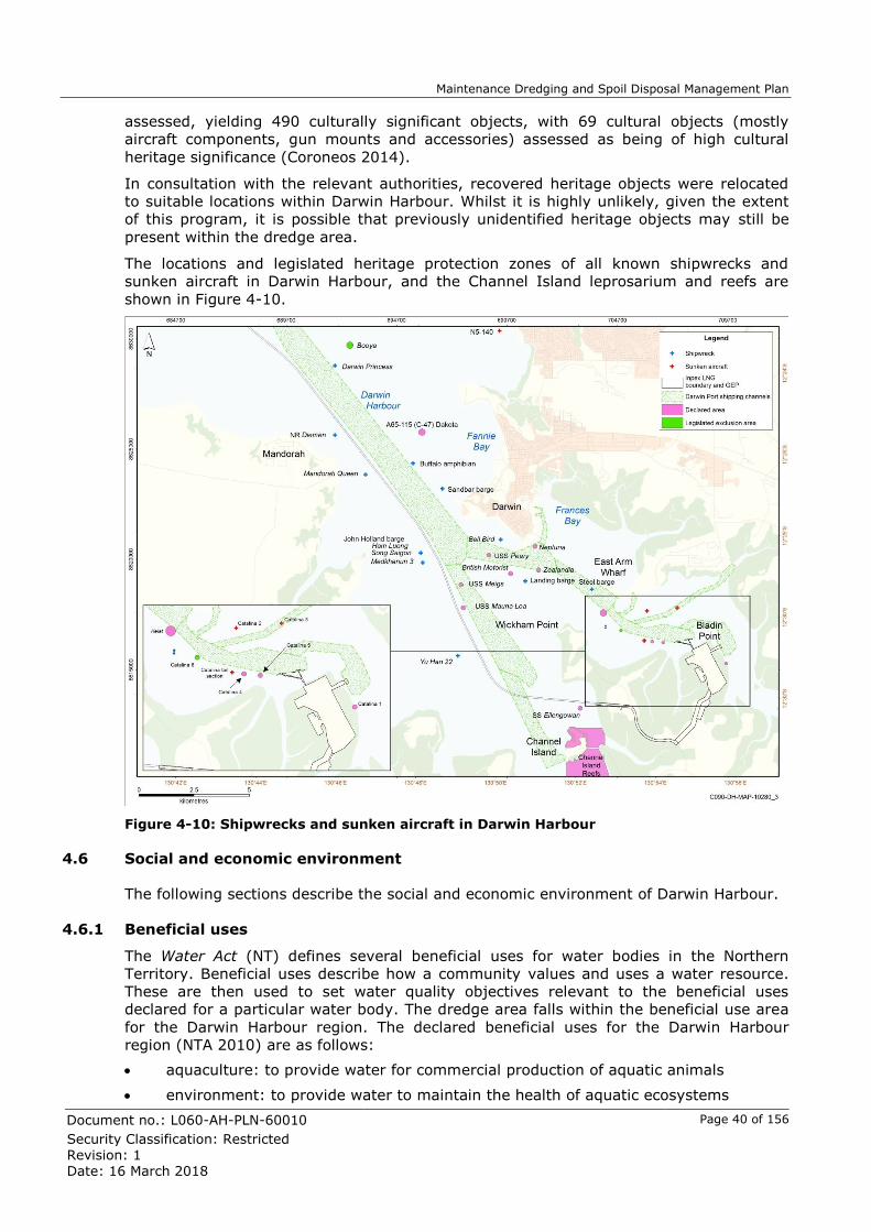
Maintenance Dredging and Spoil Disposal Management Plan
Document no.: L060-AH-PLN-60010 Page 40 of 156
Security Classification: Restricted
Revision: 1
Date: 16 March 2018
assessed, yielding 490 culturally significant objects, with 69 cultural objects (mostly
aircraft components, gun mounts and accessories) assessed as being of high cultural
heritage significance (Coroneos 2014).
In consultation with the relevant authorities, recovered heritage objects were relocated
to suitable locations within Darwin Harbour. Whilst it is highly unlikely, given the extent
of this program, it is possible that previously unidentified heritage objects may still be
present within the dredge area.
The locations and legislated heritage protection zones of all known shipwrecks and
sunken aircraft in Darwin Harbour, and the Channel Island leprosarium and reefs are
shown in Figure 4-10.
Figure 4-10: Shipwrecks and sunken aircraft in Darwin Harbour
4.6 Social and economic environment
The following sections describe the social and economic environment of Darwin Harbour.
4.6.1 Beneficial uses
The Water Act (NT) defines several beneficial uses for water bodies in the Northern
Territory. Beneficial uses describe how a community values and uses a water resource.
These are then used to set water quality objectives relevant to the beneficial uses
declared for a particular water body. The dredge area falls within the beneficial use area
for the Darwin Harbour region. The declared beneficial uses for the Darwin Harbour
region (NTA 2010) are as follows:
aquaculture: to provide water for commercial production of aquatic animals
environment: to provide water to maintain the health of aquatic ecosystems

Maintenance Dredging and Spoil Disposal Management Plan
Document no.: L060-AH-PLN-60010 Page 41 of 156
Security Classification: Restricted
Revision: 1
Date: 16 March 2018
cultural: to provide water to meet aesthetic, recreational and cultural needs
agriculture: to provide irrigation water for primary production including related research
rural stock and domestic: to provide water for specific uses.
The DSDA is located in open ocean outside of any declared beneficial use areas.
4.6.2 Darwin Port operations
Darwin Harbour is a working port and is developing into a major service centre for the
mining and energy sectors. Darwin Port operations consist of marine traffic of non-
commercial vessels (e.g. recreational anglers) and trading vessels, including commercial
ships carrying cargo and passengers, rig tenders, tankers and bulk-cargo vessels that
regularly utilise East Arm Wharf and Hudson Creek.
In 2014/2015 the Port of Darwin serviced 195 general cargo (container) vessels and a
total of 1,715 trading vessels (import and export) (Darwin Port Corporation 2015).
4.6.3 Tourism
Tourism is a large economic driver of the Northern Territory economy. During 2015/2016
there were 1,735,000 visitors to the Northern Territory (Tourism NT 2016). In 2015,
visitors to the Territory contributed an estimated $2.0 billion to the local economy (NTG
Undated).
Darwin Harbour is a prime tourism resource for the region due to its high recreational
values. Fishing, boating, sailing, water-skiing and beach use are popular activities for
tourists. Fishing tours are frequently undertaken at Fenton Patches, located
approximately 30 km north-west of Darwin Harbour. Recreational users also visit the
sandy beaches along Casuarina Bay and Lee Point (INPEX 2010).
4.6.4 Commercial fishing and aquaculture
A number of commercial fisheries operate within Northern Territory waters; however,
most are prohibited from operating within Darwin Harbour (DPIF 2015). The following
fisheries are permitted to operate within Darwin Harbour in areas that are not designated
protected areas 2 F
5:
Coastal Line Fishery
Aquarium Fish/Display Fishery.
Little to no commercial fishing is undertaken in Darwin Harbour.
The Darwin Aquaculture Centre is situated on Channel Island, west of Middle Arm
Peninsula. It is a research and development facility, which primarily focusses on the
research into tropical marine aquaculture (NTG 2016d). The centre is currently
researching ways to farm black-lipped oysters, giant clams, and sea cucumbers (NTG
2016d).
4.6.5 Recreational and traditional fishing
Results from a recreational fishing survey undertaken between April 2009 and March
2010 indicate that waterways within Darwin Harbour account for 27% of the recreational
fishing effort for the Northern Territory, with zones immediately adjacent to Darwin
(Darwin surrounds, Bynoe Harbour and Finniss areas) attracting a further 28% (West et
al. 2012).
5 Protected areas include Aboriginal sacred sites, reef fish protection areas, sanctuary zones and aquaculture farm leases.

Maintenance Dredging and Spoil Disposal Management Plan
Document no.: L060-AH-PLN-60010 Page 42 of 156
Security Classification: Restricted
Revision: 1
Date: 16 March 2018
During the NEMP, monitoring of recreational fishing activities identified distinct seasonal
target behaviour of recreational anglers with barramundi commonly targeted during the
wet season, while reef species (golden snapper and black jewfish) and pelagic (mackerel
and tuna) are more commonly targeted during the dry season. Further, monitoring
results indicated that catch rates also varied seasonally, particularly at more exposed
sites where decreased catches were recorded during the wet season (Cardno 2015f).
In addition to the recreational fishermen, Aboriginal people living in the Darwin area
frequently fish and forage for food and other resources in intertidal areas at low tide.
These activities are common around Nightcliff, Coconut Grove, Kulaluk, Sadgroves Creek
and Lee Point.

Maintenance Dredging and Spoil Disposal Management Plan
Document no.: L060-AH-PLN-60010 Page 43 of 156
Security Classification: Restricted
Revision: 1
Date: 16 March 2018
5 Environmental risk assessment
A systematic risk assessment process has been adopted for the environmental
management of maintenance dredging and spoil disposal activities. The risk assessment
process has been developed in line with Australian Standard AS/NZS ISO 31000:2009,
risk management principles and guidelines, and aligns with the systematic approach that
was applied throughout the Final EIS (INPEX 2010, 2011).
This process aligns with INPEX’s Environmental Policy, which requires the identification of
environmental hazards and risks associated with our business, and management of these
to levels that are ‘as low as reasonably practicable’ (ALARP).
During the development of the Final EIS (INPEX 2010, 2011) an environmental aspect
register was generated as a result of a series of environmental risk assessment
workshops. The risk assessment undertaken for maintenance dredging and spoil disposal
activities has considered, where relevant, the activities and environmental aspects
applicable to the capital dredging program as identified within the Final EIS (INPEX 2010,
2011).
The following sections provide an overview of the risk assessment process and outcomes.
5.1 Conceptual site model
A conceptual site model is a written or illustrated representation of the predicted
relationships between receptors or resources in the environment and the stressors to
which they may be exposed. Conceptual site models are used in the preliminary phases
of the risk assessment process to identify the linkages between hazards (i.e. sources
of/mechanisms for potential harm), exposure pathways/routes and receptors. Further, it
can be used to screen out impossible or implausible hazards in scenarios where there is
no exposure pathway/route or receptor.
The development of the conceptual site model for maintenance dredging and spoil
disposal activities has relied upon the activity description presented in Section 3 to
determine the mechanisms/sources of potential environmental impact, while the
information provided in Section 4 (existing environment) was used to determine the key
receptors. The overarching conceptual site model for maintenance dredging and spoil
disposal activities is presented in Figure 5-1.
Further, from an environmental perspective, the key risk factor of a maintenance
dredging campaign is related to the mass of sediment mobilised by dredging activities in
context of the receiving environment. As such, in addition to the broader conceptual site
model an illustrative conceptual site model of the effects of dredging-induced turbidity in
the Darwin region, in context of the natural processes driving sediment dynamics, is
provided in Figure 5-2. The key interacting factors that drive sediment dynamics in
Darwin Harbour and the natural cycles of light availability are described in Sections 4.1.1
(Climate), 4.1.3 (Oceanography) and 4.1.4 (Water Quality).

Maintenance Dredging and Spoil Disposal Management Plan
Document no.: L060-AH-PLN-60010 Page 44 of 156
Security Classification: Restricted
Revision: 1
Date: 16 March 2018
Figure 5-1: Maintenance dredging conceptual site model
Conceptual site model
Mechanism Pathway Exposure route Environmental receptors Cultural receptors Social receptors
Benthic
habitat
Protected
marine
megafauna
General
environment
Heritage
site
ü (primary)
ü (secondary)Sediment released
during dredging and
disposal
Suspended
sediment in water
(turbid plume)
Reduced photosynthesis
Visual amenity
Reduced water quality
Operation of TSHD
draghead
Use of draghead/
suction pipe
Entrainment of protected marine
megafauna
Discovery of UXO
Presence of dredge
and auxiliary vesselVessel movements
Smothering of aerial roots and benthic
habitats
Visual amenity
Accidental vessel collision causing
injury or mortality to protected marine
megafauna
Disturbance to sensitive benthic habitat
Physical contact to wrecks or sacred
sites
Scouring of heritage wreck sites
Entering sacred sites or heritage
exclusion zones
Unplanned
anchoring
Dredge movementsVessel movements
(propulsion)
ü
ü (primary)
ü (secondary)
ü
ü
ü
ü ü
ü ü
ü ü
ü ü
ü ü
ü ü ü
Vessel safety exclusion zone
Creation of shipping navigation
hazardsDredging operations
Disturbance to benthic areas outside
dredge and DSDA footprint
Dredging and spoil
disposal
Nutrient enrichment Liquid discharges to
water
Generation of food
scraps and sewage
Pollution of the marine environment
Ingestion by marine fauna
Visual amenity
Accidental release
to waterGeneration of waste
Behavioural changes to protected
marine megafauna
Dredging and spoil
disposalUnderwater noise
Pollution of the marine environmentAccidental release
to water
Chemical and
hydrocarbons
ü ü ü Accidental introduction and
establishment of marine pests
Biofouling/high-risk
ballast water
International vessel
movements
Community/
people
ü
ü
ü
ü
ü
ü
ü
ü
ü
ü
Sacred site
ü
ü
Commercial
ü
ü
Auxiliary vessels
Settling of
suspended sediment
(sedimentation)
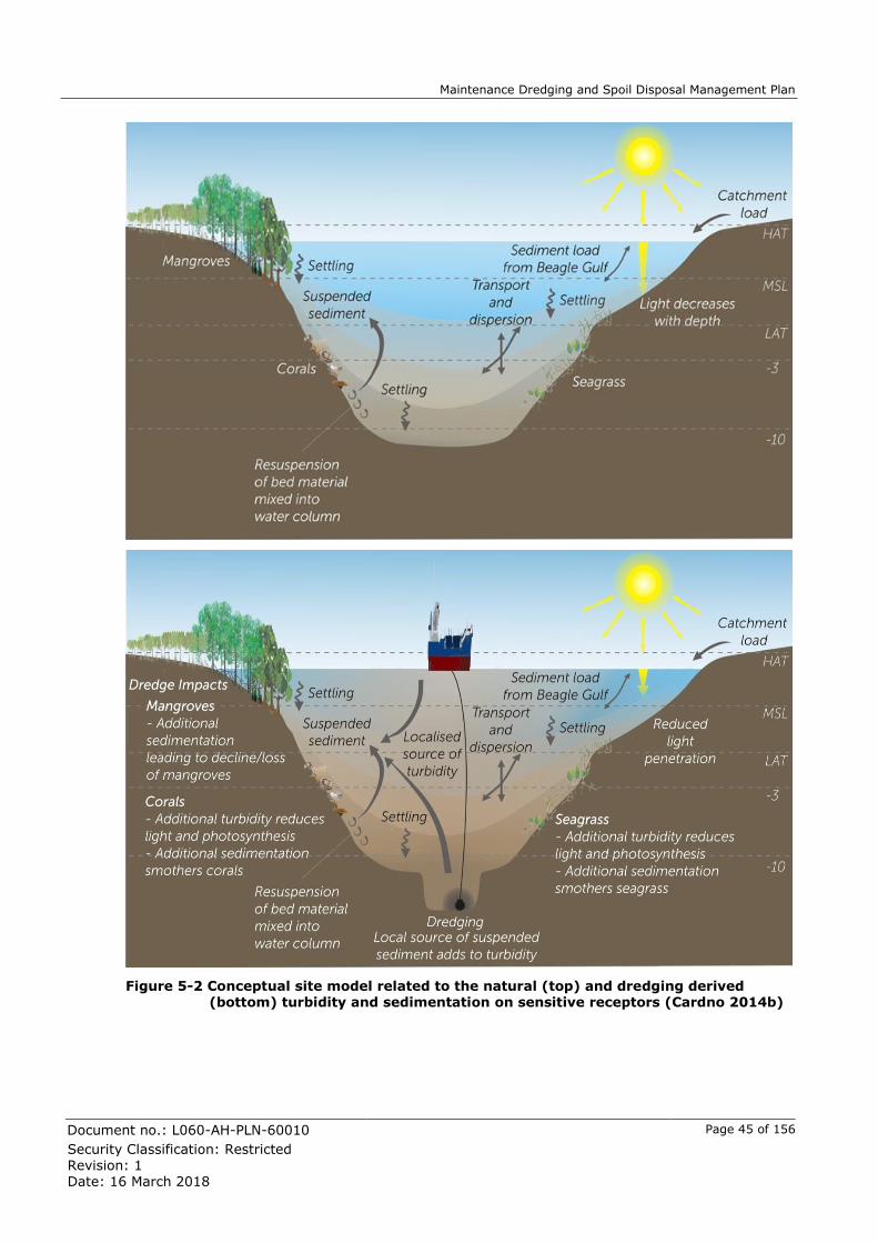
Maintenance Dredging and Spoil Disposal Management Plan
Document no.: L060-AH-PLN-60010 Page 45 of 156
Security Classification: Restricted
Revision: 1
Date: 16 March 2018
Figure 5-2 Conceptual site model related to the natural (top) and dredging derived (bottom) turbidity and sedimentation on sensitive receptors (Cardno 2014b)

Maintenance Dredging and Spoil Disposal Management Plan
Document no.: L060-AH-PLN-60010 Page 46 of 156
Security Classification: Restricted
Revision: 1
Date: 16 March 2018
5.2 Summary of risk assessment outcomes
The maintenance dredging risk assessment was informed by the conceptual site models
described in Section 5.1. For the purposes of the risk assessment, an environmental
aspect is defined as a feature or characteristic of the maintenance dredging or spoil
disposal activities that has the potential to affect the environment.
Following the identification of activities, which could result in a particular environmental
aspect, the potential environmental impacts associated with each aspect were identified.
For each source of environmental risk, control measures were then identified for
evaluation. Where the level of risk reduction achieved by these control measures was
determined to be grossly disproportionate to the “cost” 3 F
6 of implementing them, the
control measure was not included, and the risk was considered to be managed to ALARP.
Justification for these is presented in Section 5.3.
The consequence and likelihood of each impact was then assessed to determine the
residual risk that remained after controls to be implemented were taken into
consideration.
The consequence is defined as an outcome or impact from an event occurring. For the
purposes of the assessment, the consequence level applied was based on the credible
worst-case scenario and assumed no control measures were in place. The category of
environmental consequence and the detailed definitions for each severity level are
described in Figure 5-3.
The likelihood can be described as the level of probability that, or the frequency with
which, the described consequence will impact upon the environment. When determining
the likelihood of a consequence occurring, any proposed control measures identified to
mitigate the potential impact were taken into account.
The risk matrix used to determine the risk of impact for maintenance dredging and spoil
disposal activities is provided in Figure 5-4.
The outcomes of the risk assessment are presented in Table 5-1, and where relevant
includes reference to the environmental management frameworks within this
Maintenance DSDMP used to manage individual environmental aspects.
6 Cost includes financial cost, time or duration, effort, occupational health and safety risks, or environmental impacts associated with implementing the control.

Maintenance Dredging and Spoil Disposal Management Plan
Document no.: L060-AH-PLN-60010 Page 47 of 156
Security Classification: Restricted
Revision: 1
Date: 16 March 2018
Figure 5-3: INPEX Environmental consequence table

Maintenance Dredging and Spoil Disposal Management Plan
Document no.: L060-AH-PLN-60010 Page 48 of 156
Security Classification: Restricted
Revision: 1
Date: 16 March 2018
Figure 5-4: INPEX Risk Matrix

Maintenance Dredging and Spoil Disposal Management Plan
Document no.: L060-AH-PLN-60010 Page 49 of 156
Security Classification: Restricted
Revision: 1
Date: 16 March 2018
Table 5-1: Summary of risk assessment outcomes
Aspect Activity Potential impacts Management controls and mitigating factors
Residual risk summary
Consequence Likelihood Risk
Turbid plumes
Dredging and spoil disposal activities
Elevated turbidity and associated low
light conditions resulting in mortality of coral and seagrass communities
Risk is considered ALARP, refer to Section 5.3.1
For adaptive management refer to Section 7.1: Management of sediment-related effects
Insignificant (B2)
Highly unlikely
Low
Coral reproductive cycles may be
affected by elevated turbidity and associated sedimentation resulting in loss of recruitment
Risk is considered ALARP, refer to Section 5.3.1
For adaptive management refer to Section 7.1: Management of sediment-related effects
Insignificant (B2)
Unlikely Low
Reduction in access to food resources for dugongs, dolphins and turtles
Risk is considered ALARP, refer to Section 5.3.1
For adaptive management refer to Section 7.1: Management of sediment-related effects
Insignificant (B1)
Highly unlikely
Low
Coastal sedimentation
Dredging and spoil disposal activities
Sediment accumulation in intertidal areas resulting in a decline of mangrove community health
Risk is considered ALARP, refer to Section 5.3.1
For adaptive management refer to Section 7.1: Management of sediment-related effects
Insignificant (B2)
Highly unlikely
Low
Low level deposition of sediments on subtidal and intertidal marine habitats causing mortality of coral and seagrass communities
Risk is considered ALARP, refer to Section 5.3.1
For adaptive management refer to Section 7.1: Management of sediment-related effects
Insignificant (B2)
Highly unlikely
Low
Dredge and support vessel
Dredging and spoil disposal activities
Vessel collision causing injury or mortality to protected marine megafauna
Refer to Section 7.2.2: Protected marine megafauna management framework
Moderate (B1)
Remote Low

Maintenance Dredging and Spoil Disposal Management Plan
Document no.: L060-AH-PLN-60010 Page 50 of 156
Security Classification: Restricted
Revision: 1
Date: 16 March 2018
Aspect Activity Potential impacts Management controls and mitigating factors
Residual risk summary
movements.
Operation of the TSHD draghead
Entrainment of marine turtles or sawfish causing injury or mortality
Refer to Section 7.2.2: Protected marine megafauna management framework
Moderate (B1)
Highly unlikely
Moderate
Disturbance or damage to protected heritage wrecks or sacred sites
Refer to Section 7.2.4: Heritage and sacred site management framework
Significant
(S1, S2)
Highly unlikely
Moderate
Discovery and damage to previously unidentified heritage objects
Risk is considered ALARP, refer to
Section 5.3.3: Unexploded ordnance and heritage objects
For chance find procedure refer to Section 7.2.4: Heritage and sacred site management framework
Insignificant (S2)
Remote Low
Discovery and disturbance of
unexploded ordnance (UXO) potentially posing a risk to personnel and members of the public
Risk is considered ALARP, refer to
Section 5.3.3: Unexploded ordnance and heritage objects
Significant Remote Moderate
Maritime traffic and navigation
Dredging and dredge disposal activities
Localised displacement of port users as a result of temporary safety zone around TSHD
Refer to Section 7.2.2: Dredge materials management framework
Insignificant Possible Low
Creation of shipping navigation hazards
resulting from accidental disposal of spoil outside of the DSDA
Refer to Section 7.2.2: Dredge materials management framework
Insignificant Remote Low
Dredge material
Dredging and dredge disposal activities
Accidental removal of coral in the event
dredging occurs outside designated areas
Refer to Section 7.2.2: Dredge materials management framework
Insignificant (B3)
Remote Low
Accidental smothering of coral or
seagrass in the event spoil is disposed of outside of the DSDA
Refer to Section 7.2.2: Dredge materials management framework
Insignificant (B3)
Remote Low
Dredge material
Seabed levelling activities
Accidental disturbance to coral in the
event seabed levelling occurs outside designated areas
Refer to Section 7.2.2: Dredge materials management framework
Insignificant (B3)
Remote Low

Maintenance Dredging and Spoil Disposal Management Plan
Document no.: L060-AH-PLN-60010 Page 51 of 156
Security Classification: Restricted
Revision: 1
Date: 16 March 2018
Aspect Activity Potential impacts Management controls and mitigating factors
Residual risk summary
Sewage/food scraps discharges
Routine operation of TSHD vessel
Localised nutrient enrichment of marine environment
Refer to Section 7.2.5: Waste and liquid discharge management framework
Insignificant (E1)
Remote Low
Waste Generation of
hazardous/non-hazardous wastes during routine vessel operations
Accidental loss of hazardous/non-
hazardous wastes to the water resulting in localised pollution to the marine environment or ingestion by marine fauna
Refer to Section 7.2.5: Waste and liquid discharge management framework
Insignificant
(B3)
Unlikely Low
Underwater noise
Operation of the draghead during dredging
Localised avoidance of the area by protected marine megafauna
Risk is considered ALARP, refer to Section 5.3.2: Underwater noise
Insignificant (B1)
Unlikely Low
General dredge and
support vessel movements
Chemical and hydrocarbons
Storage and handling
of chemicals during dredging activities
Accidental loss of chemicals to the
water resulting in localised pollution to the marine environment
Refer to Section 7.2.6: Hydrocarbon and
chemical management spill response framework
Insignificant (B3)
Highly unlikely
Low
Minor hydrocarbon spills associated with equipment failure (e.g. burst hydraulic hose)
Accidental loss of hydrocarbons to the water resulting in localised pollution to the marine environment
Refer to Section 7.2.6: Hydrocarbon and chemical management spill response framework
Insignificant (B3)
Unlikely Low
Major hydrocarbon
spills associated with equipment/ operator failure (e.g. loss of containment during bunkering)
Accidental loss of hydrocarbons to the water resulting in:
- exposure of nearshore water to moderate levels of hydrocarbons causing pollution
- localised areas of mangroves and intertidal communities exposed to moderate levels of hydrocarbons resulting in mortality
Refer to Section 7.2.6: Hydrocarbon and
chemical management spill response framework
Minor (B3) High unlikely
Moderate

Maintenance Dredging and Spoil Disposal Management Plan
Document no.: L060-AH-PLN-60010 Page 52 of 156
Security Classification: Restricted
Revision: 1
Date: 16 March 2018
Aspect Activity Potential impacts Management controls and mitigating factors
Residual risk summary
Introduction of marine pests
Import of dredge vessel from overseas locations
Accidental introduction of marine pests resulting in:
- displacement of native species
- alteration and/or degradation of habitats and ecosystems
- potential impact on maritime-based industries
Refer to Section 7.2.1: Introduced marine pest management framework
Moderate (B3)
Remote Low

Maintenance Dredging and Spoil Disposal Management Plan
Document no.: L060-AH-PLN-60010 Page 53 of 156
Security Classification: Restricted
Revision: 1
Date: 16 March 2018
5.3 ALARP Justification
5.3.1 Sediment-related impacts
Sensitive receptors (mangroves, coral and seagrass)
Sediment-related impacts associated with dredging and spoil disposal activities can be
separated into direct and indirect effects (Erftemeijer et al. 2012; Jones et al. 2016; Mills
& Kemps 2016). Direct effects include the removal of substrate within the dredge area
and smothering of substrate at the DSDA during disposal. The substrate within and
directly adjacent to both the dredge area and the DSDA is classified as soft-bottom
benthos, and is well represented over large areas regionally (Section 4.2.5). Following
completion of maintenance dredging activities, rapid recolonisation by fauna is expected
to occur in these areas, similar to what was reported for the capital dredging program
(Cardno 2015g).
Dredging and spoil disposal activities also have the potential to indirectly impact sensitive
receptors such as coral, seagrass and mangrove communities through the release of
additional sediments into the water column, which can be dispersed, resuspended and
allowed to settle through oceanographic and sediment transport processes. Indirect
effects to sensitive receptors associated with the mobilisation of sediment can be divided
into chemical or physical effects (Jones et al. 2016).
The potential for chemical effects largely relate to the contamination status of the
sediment, which if contaminated may cause acute and chronic toxicological effects,
cellular and physiological effects as well as bioaccumulation effects (Jones et al. 2016).
Based on the sediment quality assessment (Section 4.1.5; INPEX 2016), the deposited
sediment to be dredged during a maintenance dredging campaign was found to consist of
uncontaminated silt and fine sands. The risk of chemical effects is therefore considered
ALARP and not discussed further.
Physical effects relate to elevated concentrations of suspended sediment (turbidity),
changes in light quality and quantity, and sedimentation (Jones et al. 2016). Elevated
turbidity within the water column reduces light penetration and therefore the availability
of light for photosynthesis (Erftemeijer et al. 2012). This has the potential to impact
water column producers (e.g. phytoplankton) and benthic primary producers (e.g.
seagrasses and autotrophic corals), with impact severity dependent upon the life history
of the receptor affected and the intensity, duration and frequency of adverse events
relative to the natural background conditions to which the receptors are adapted.
Deposition and accumulation of sediments within intertidal and subtidal areas also has
the potential to affect sensitive receptors. Excess deposition of sediment (>50 mm;
INPEX 2010) may cause stress to mangroves (particularly in the seaward assemblage)
due to smothering and burial of aerial root systems, with impacts ranging from reduced
vigour to mortality, depending on the species and sediment characteristics (Cardno
2015b). Elevated sedimentation rates in intertidal and subtidal areas may also suppress
coral growth and survival when energy expenditure is redirected to actively clear settled
sediments from coral tissue (Erftemeijer et al. 2012; Jones et al. 2016). Corals and
seagrasses can also be impacted through smothering due to excessive sedimentation,
with consequences depending on the depth of burial and life history of species affected
(Duarte et al. 1997; Erftemeijer & Lewis 2006).

Maintenance Dredging and Spoil Disposal Management Plan
Document no.: L060-AH-PLN-60010 Page 54 of 156
Security Classification: Restricted
Revision: 1
Date: 16 March 2018
The likelihood of indirect physical effects associated with a maintenance dredging
campaign is directly related to the type and size of dredge vessel proposed and its
operating profile with regards to the mass fraction of fines (<75 µm) 4F
7 lost to the
environment. An increase in the amount of fines released to the marine environment
from dredging activities will generally lead to an increase in the spatial extent and
magnitude of sediment plumes, as well as an increased rate of sediment deposition and
associated resuspension (Mills & Kemps 2016).
As described in Section 3.3, a TSHD is proposed to carry out the maintenance dredging
activities. At the dredging site, the predominant source of fine sediment released by
TSHD operations is from the overflow of water (containing some fine sediments), while
by comparison sediment release rates at the draghead are typically insignificant (Mills &
Kemps 2016). As such it is proposed that overflow funnel/s are fitted with green valves
(as per best practice), and overflow duration is managed to a maximum of 60 minutes
(Section 3.3.2), as was approved for the capital dredging program. This is to limit the
amount of fines released into the Darwin Harbour environment when compared to
unrestricted overflow. At the DSDA, the dominant source of fine sediment is associated
with disposal, which as per the rationale provided in Section 3.3.3 is via bottom door
placement.
To determine the likelihood for indirect effects to sensitive receptors, predictive modelling
of fine sediment released by TSHD operations and a subsequent habitat impact
assessment (using ecological tolerance limits) has been completed for the worst-case
credible scenario (Section 6.1), as recommended in Mills and Kemps (2016). Results
from the sediment plume modelling and impact assessment are described in Section 6.8.
Overall it was found that <1 ha of coral (as a component of Mixed Community; Reef
habitat5F
8) is simulated to be indirectly impacted due to maintenance dredging operations.
No impacts to high-confidence or inferred seagrass or mangrove communities are
predicted.
The risk of sediment-related effects to sensitive receptors and hence protected marine
megafauna foraging habitat is found to be ALARP. This is in consideration of the
modelling outcomes and the fact that no dredging-attributable mortality of sensitive
receptor communities was measured at monitoring sites during the much larger capital
dredging program, even at sites where 100% loss had been predicted (Cardno 2015b,
2015c, 2015d), for example at South Shell Island which was immediately adjacent to the
capital dredging footprint.
Further, adaptive management of the maintenance dredging activity based on water
quality monitoring is proposed (Section 7.1). One of the key objectives of adaptive
management is to use monitoring data to inform the management of the dredging
operations, to minimise the potential for impacts to the sensitive receptors (if any)
through timely implementation of responsive and contingency management practices.
7 The Australian Standard (Geotechnical site investigations) AS 1726-1993 defines fine sediment as a particle size less than 75 µm. 8 Based on the outcomes of habitat mapping and classification undertaken for the Final EIS (INPEX 2010; 2011), Mixed Community; Reef habitat consists of macroalgae (8%), hard coral (15%), filter-feeder (29%) and <10% macrobiota (47%). Note these percentages do not refer directly to percent cover but rather are an allocated attribute based on biota classification definitions. Mixed Community; Reef habitat in the Darwin region comprises 8,231 ha, of which only 8% is high confidence and the remainder inferred. As such 1,235 ha of coral habitat could be assumed as a component of Mixed Community; Reef.

Maintenance Dredging and Spoil Disposal Management Plan
Document no.: L060-AH-PLN-60010 Page 55 of 156
Security Classification: Restricted
Revision: 1
Date: 16 March 2018
Reproductive cycle of corals
In a recent review undertaken by Jones et al. (2015a)6F
9, it was found that elevated
concentrations of suspended sediment (associated light attenuation) and excess
sedimentation both have the potential to cause adverse effects to early life stages of
corals, including gametogenesis, timing and synchronisation of spawning, egg-sperm
bundle buoyancy, fertilisation success, embryogenesis, early larval development,
settlement and post-metamorphosis survival. Thus, Jones et al. (2015a) concluded that
conducting maintenance dredging activities outside of coral spawning and settlement
periods would constitute a best management practice. As such, the potential for
sediment-related effects on the reproductive cycle of corals has also been specifically
considered.
Information pertaining to the location, family composition and likely spawning period of
coral communities in Darwin Harbour is provided in Section 4.2.1. There is limited
reproductive data for coral assemblages in the Darwin region and in terms of timing for
specific families, information is limited to Faviidae, where mature eggs were detected in
April (Cardno 2015c), which is consistent with broadcast spawning following the April full
moon. The Faviidae were represented at all sites monitored during the NEMP (Cardno
2015c).
High-confidence Hard Coral; Reef habitat at South Shell Island and Northeast Wickham
Point in proximity to the dredge area are characterised by a low cover (<1%) of Faviidae
corals, suggesting these habitats and the naturally prevailing background conditions,
may not be conducive to recruitment. In contrast, Channel Island and Weed Reef located
further afield have a higher relative percent cover of Faviidae at 3.1% and 2.3%,
respectively. At these sites, Faviidae contributed 15% to 25% of the live coral cover, with
corals in the families Pectinidae and Poritidae also important (Cardno 2015c).
As a group, these three families contribute the major components of coral cover in the
various communities throughout the Harbour. Although no data is available for sexual
reproduction of the Pectinids or Poritids in Darwin Harbour, corals in those families are
also known to reproduce via broadcast spawning in seasonal synchrony with Favid
species (Gilmour et al. 2016), suggesting that the April spawning period may be relevant
to many of the dominant corals in the Harbour.
The risk of interaction between the excess (i.e. dredging-related) suspended sediment
plume and the various reproductive stages of coral has been assessed in context of the
modelling results discussed in Section 6. Specifically, larvae present in the water column
that may interact with the highest suspended sediment plume concentration (in the
dredge area), and gametes and newly settled juveniles that will only interact where the
sediment plume extends over benthic habitat known to support coral communities (e.g.
Hard Coral; Reef and Mixed Community; Reef).
Modelling simulates maximum concentrations of 100 to 200 mg/L (excess SSC) to occur
for no more than 5% of the time within a localised portion of the dredge area, and
concentrations of 20 to 50 mg/L to occur for no more than 10% of the time within and
directly adjacent to (upstream) the dredge area. These areas are characterised by soft-
bottom benthos (Section 6.5.1).
Studies undertaken by Gilmour (1999) and Humphrey et al. (2008) found no effect to
early embryonic development at the highest concentrations tested on Acropora digitifera
(100-150 mg/L) and Acropora millepora (200 mg/L) respectively (Jones et al. 2015a).
9 Review undertaken as a part of the Western Australia Marine Science Institution (WAMSI) Dredging Science Node, which is a strategic research initiative that aims to enhance capacity within government and the private sector to predict and manage the environmental impacts of dredging in Western Australia.

Maintenance Dredging and Spoil Disposal Management Plan
Document no.: L060-AH-PLN-60010 Page 56 of 156
Security Classification: Restricted
Revision: 1
Date: 16 March 2018
While, with respect to larval survival Gilmour (1999) found that it may be affected at
concentration as low as 50 mg/L.
To the extent that these studies can be used as a surrogate for deriving impact
thresholds for coral life history stages within Darwin Harbour, it may be inferred that if
maintenance dredging is undertaken around the time of coral spawning that within the
dredge area, where SSC is highest, there is potential for indirect effects to coral larvae.
No effects to early embryonic development are expected; however, larval survival in the
immediate dredge area may be effected.
In context of the localised area of maximum SSC (i.e. dredge area), the short duration
and the intermittent nature of the maintenance dredging activity, the overall risk to larval
development and survivorship in the broader Darwin Harbour is considered low.
To assess the potential effects of suspended sediment plumes and sedimentation on coral
gametes and newly settled juveniles, modelling outcomes were also interrogated.
Modelling results suggest that net sedimentation is unlikely to occur in subtidal areas in
East Arm due to the fine nature of the sediment and the prevailing hydrodynamics.
Therefore, the potential for effects, to these life stages are related to the concentration of
the suspended sediment plumes.
Only a minor proportion of Mixed Community; Reef habitat directly upstream of the
dredge area is predicted to be affected by elevated SSC of 10 to 20 mg/L for no more
than 10% of the time. Hard Coral; Reef habitat at South Shell Island (8% coral cover)
and Northeast Wickham Point (2% coral cover) in East Arm are predicted to experience
elevated SSC of 3 to 5 mg/L for no more than 10% of the time. While Weed Reef coral
communities (average 13% coral cover) and nationally recognised Channel Island coral
communities (14% coral cover) are not predicted to experience any elevated SSC as a
result of maintenance dredging activities.
A study by Te (1992) found that there was no significant difference in settlement of
Pocillopora damicornis when exposed to 0, 10, 100 and 1,000 mg/L, with the exception
of reversed metamorphosis (e.g. polyp bailout) at 100 and 1,000 mg/L (Erftemeijer et al
2012; Jones et al 2015a). Given the modelled SSC over known coral communities is well
below these levels, it is unlikely that significant effects to settlement will occur. It is
noted that a reduction in light associated with elevated suspended sediment may also
effect settlement; however, given the modelled spatial extent of the suspended sediment
plume and the naturally turbid water experienced in Darwin Harbour, the risk is
considered low.
Overall in review of the modelling results and in context of the spatial extent and
intensity of the suspended sediment plumes, the short duration and intermittent nature
of the maintenance dredging activities, the risk from excess suspended sediment plumes
on the reproductive cycle of corals in Darwin Harbour is considered low, particularly at
high confidence Hard Coral; Reef habitat areas within Darwin Harbour.
Further, the potential additional "costs"6 of temporally restricting maintenance dredging
(e.g. outside of spawning and settlement periods) would be grossly disproportionate to
the risk. The risk from excess suspended sediment plumes on the reproductive cycle of
corals is therefore considered ALARP. Noting that the adaptive management strategy
described in Section 7.1 provides for changes to the dredging operations based on
measured water quality (i.e. turbidity) should they significantly differ from modelling
prediction.
Fish
Suspended sediments from dredging and spoil disposal activities can have both positive
and negative impacts on fish species. Some species (e.g. barramundi, mangrove jack
and jewfish) may be attracted to disturbed areas to feed on suspended invertebrates or
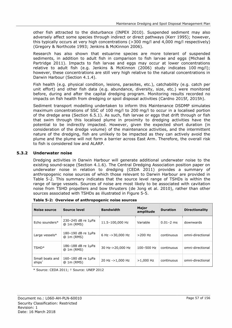
Maintenance Dredging and Spoil Disposal Management Plan
Document no.: L060-AH-PLN-60010 Page 57 of 156
Security Classification: Restricted
Revision: 1
Date: 16 March 2018
other fish attracted to the disturbance (INPEX 2010). Suspended sediment may also
adversely affect some species through indirect or direct pathways (Kerr 1995); however,
this typically occurs at very high concentrations (>300 mg/l and 4,000 mg/l respectively)
(Gregory & Northcote 1993; Jenkins & McKinnon 2006).
Research has also shown that estuarine species are more tolerant of suspended
sediments, in addition to adult fish in comparison to fish larvae and eggs (Michael &
Partridge 2011). Impacts to fish larvae and eggs may occur at lower concentrations
relative to adult fish (e.g. Jenkins & McKinnon (2006) study indicates 100 mg/l);
however, these concentrations are still very high relative to the natural concentrations in
Darwin Harbour (Section 4.1.4).
Fish health (e.g. physical condition, lesions, parasites, etc.), catchability (e.g. catch per
unit effort) and other fish data (e.g. abundance, diversity, size, etc.) were monitored
before, during and after the capital dredging program. Monitoring results recorded no
impacts on fish health from dredging or spoil disposal activities (Cardno 2015f, 2015h).
Sediment transport modelling undertaken to inform this Maintenance DSDMP simulates
maximum concentrations of SSC of 100 mg/l to 200 mg/l to occur in a localised portion
of the dredge area (Section 6.5.1). As such, fish larvae or eggs that drift through or fish
that swim through this localised plume in proximity to dredging activities have the
potential to be indirectly impacted. However, given the expected short duration (in
consideration of the dredge volume) of the maintenance activities, and the intermittent
nature of the dredging, fish are unlikely to be impacted as they can actively avoid the
plume and the plume will not form a barrier across East Arm. Therefore, the overall risk
to fish is considered low and ALARP.
5.3.2 Underwater noise
Dredging activities in Darwin Harbour will generate additional underwater noise to the
existing sound-scape (Section 4.1.6). The Central Dredging Association position paper on
underwater noise in relation to dredging (CEDA 2011) provides a summary of
anthropogenic noise sources of which those relevant to Darwin Harbour are provided in
Table 5-2. This summary indicates that the source level range of TSHDs is within the
range of large vessels. Sources of noise are most likely to be associated with cavitation
noise from TSHD propellers and bow thrusters (de Jong et al. 2010), rather than other
sources associated with TSHDs as illustrated in Figure 5-5.
Table 5-2: Overview of anthropogenic noise sources
Noise source Source level Bandwidth Major amplitude
Duration Directionality
Echo sounders* 230–245 dB re 1µPa @ 1m (RMS)
11.5–100,000 Hz Variable 0.01–2 ms downwards
Large vessels* 180–190 dB re 1µPa @ 1m (RMS)
6 Hz ->30,000 Hz >200 Hz continuous omni-directional
TSHD* 186–188 dB re 1µPa @ 1m (RMS)
30 Hz->20,000 Hz 100–500 Hz continuous omni-directional
Small boats and ships†
160–180 dB re 1µPa @ 1m (RMS)
20 Hz ->1,000 Hz >1,000 Hz continuous omni-directional
* Source: CEDA 2011; † Source: UNEP 2012

Maintenance Dredging and Spoil Disposal Management Plan
Document no.: L060-AH-PLN-60010 Page 58 of 156
Security Classification: Restricted
Revision: 1
Date: 16 March 2018
Figure 5-5: TSHD sound sources (CEDA 2011)
When assessing the potential effects of anthropogenic sources of underwater noise on
marine fauna Richardson et al. (1995) developed a "zone of influence model" which is
based on the distance between the source and receiving fauna. This is premised on the
fact that underwater sound reduces in intensity with increasing distance from the source,
which can be influenced by a range of variables (e.g. substrate type, suspended
sediment load, depth of source, etc.) (WODA 2013). As such, potential effects may range
from masking important biological functions (e.g. communication and echolocation of
prey), behavioural responses (e.g. avoidance) through to temporary or permanent
threshold shifts (TTS and PTS) (e.g. physiological effects). All of which can vary between
species depending on their sensitivity to underwater sound and their hearing range.
Darwin Harbour noise exposure modelling was undertaken for the capital dredging
program based on cutter suction dredge activities at Walker Shoal (hard conglomerate
rock). This was considered the greatest risk for the generation of underwater noise
during the capital dredging program as it involved the grinding of hard rock, while in
contrast TSHD operations involved dredging up loose sediments (URS 2011). Modelling
indicated cutter suction dredging noise exposure levels were within the safe hearing
ranges of marine fauna that frequent Darwin Harbour and that any impacts would likely
be behavioural responses (e.g. avoidance of the immediate area). In addition, the
greater part of the Harbour would be unaffected by noise associated with dredging
activities (URS 2011).
Marine fauna (i.e. turtles, dugongs, dolphins and fish) monitoring undertaken during the
capital dredging program, found that there had been no impacts to marine fauna as a
result of noise associated with dredging operations (Cardno 2015h; Cardno 2015e;
Brooks & Pollock 2015b). Dolphins were observed in East Arm throughout the capital
dredging program (Brooks & Pollock 2015b) as were turtles (Cardno 2015e), while
dugongs were primarily observed outside Darwin Harbour in association with seagrass
beds with very few sightings within the Harbour (Cardno 2015g). This is expected given
that noise generated in the middle area of East Arm attenuated rapidly and was mostly
masked by other man made noises at the mouth of East Arm opposite the East Arm
Wharf. Sources of noise generated from vessels could not be distinguished between
dredge related or other sources (Gavrilov & Salgado-Kent 2015).
In context of the modelling and monitoring results, underwater noise generated by
maintenance dredging is unlikely to impact marine fauna given a single TSHD is
proposed, which in terms of underwater noise is similar to large vessels that already
frequent Darwin Harbour and hence the risk is considered low and ALARP.

Maintenance Dredging and Spoil Disposal Management Plan
Document no.: L060-AH-PLN-60010 Page 59 of 156
Security Classification: Restricted
Revision: 1
Date: 16 March 2018
5.3.3 Unexploded ordnance (UXO) and heritage objects
The dredge area is located in a part of Darwin Harbour that was subject to bombing
activity in World War II.
Prior to the execution of the capital dredging program a detailed study was undertaken to
assess the likely presence of unexploded ordnances (UXOs) and explosive ordnances
(EOs). The study identified that the north-western section of the proposed dredge area
was a high risk in terms of the existence of UXOs and EOs.
Following this initial assessment, INPEX appointed Tek Ventures Pty Ltd (TV), in
consultation with Cosmos Maritime Archaeology (CA), to undertake gradiometer and side
scan sonar surveys within the capital dredge area to determine the presence of ferrous
and magnetic anthropogenic anomalies (up to one metre below the seabed). The surveys
identified ~1000 anomalies located on and under the seabed. These anomalies were then
inspected by TV divers, with CA archaeologist assisting, to determine if these anomalies
were natural or cultural in origin.
During diving inspections, only one object was identified as potentially being a UXO. In
May 2012, this was further assessed and inspected by Royal Australian Navy divers, and
subsequently raised and disposed of.
A total of 6,897 artefacts were assessed, yielding 490 culturally significant objects, with
69 cultural objects (mostly aircraft components, gun mounts and accessories) assessed
as being of high cultural heritage significance (Coroneos 2014). In consultation with the
relevant authorities, 506 heritage objects were relocated to suitable locations within
Darwin Harbour.
With consideration of the UXO clearance works undertaken prior to the capital dredging
program and the fact that no UXOs were encountered during the execution of the capital
dredging program, it would be highly unlikely that UXOs would be encountered during
the execution of a maintenance dredging campaign and the risk is therefore considered
low and ALARP.
Further, given the extensive heritage recovery and relocation program undertaken, it is
highly unlikely that any further (previously unidentified) heritage objects would be
discovered during the course of the maintenance dredging program. However, a chance
find procedure will be in place in the event such a discovery is made (Section 7.2.4;
Figure 7-6).
5.4 Assessment of potential for cumulative impacts
The following sections describe the assessment of the potential for cumulative impacts
due to sequential Project-related maintenance dredging campaigns and concurrent
Harbour-wide campaigns, in addition to the potential long-term effects on the sediment
balance of East Arm, Darwin Harbour.
5.4.1 Sequential Project-related maintenance dredging campaigns
The potential for cumulative impacts is related to the intensity, duration and frequency of
the activity. With respect to maintenance dredging this type of activity, in most cases, is
significantly reduced in comparison to capital dredging programs.
Maintenance dredging by definition is a repetitive activity (Netzband et al. 2009). As
described in Section 3.1, this Maintenance DSDMP has been prepared to allow for a
maximum of 1.5 Mm3 of material to be dredged at any time during the life of the
approval (i.e. nominally five years), with no single campaign to exceed 0.75 Mm3 (as
modelled). The total volume is considered worst-case and includes a planned
maintenance dredging campaign and up to four contingency campaigns.

Maintenance Dredging and Spoil Disposal Management Plan
Document no.: L060-AH-PLN-60010 Page 60 of 156
Security Classification: Restricted
Revision: 1
Date: 16 March 2018
In terms of the potential for cumulative impacts, the worst-case (not credible) scenario
would be back-to-back maintenance campaigns up to the total volume of 1.5 Mm3, using
a single TSHD (hence intermittent dredging). The capital dredging program was
approximately 10 and 11 times greater in duration and volume respectively, and near-
continuous operations. Environmental monitoring during the capital dredging program
recorded only minimal dredging-related effects to sensitive receptors at sites in proximity
to dredging7F
10 and no dredging-related effects to protected marine megafauna 8F
11.
Therefore, given the short duration and lower relative intensity, it is highly unlikely that
even back-to-back maintenance campaigns would result in impacts to receiving sensitive
receptors or protected marine megafauna.
Further, the potential for back-to-back maintenance dredging campaigns is unlikely, as it
would require a significant deposition event to occur immediately post completion of a
planned campaign. Likely sources of sediment within Darwin Harbour are related to
sediment-laden runoff from high rainfall, and increased magnitude of sediment transport
through resuspension (and deposition) of seabed sediments as a result of increased wind
speeds and wave heights associated with episodic weather events (e.g. tropical cyclone).
A review of BOM rainfall (BOM 2016a) and cyclone data (BOM 2016e) for the Darwin
region 9F
12 has been completed and as expected, Figure 5-6 shows that 95% of the annual
rainfall and all tropical cyclone development occur in the wet season. This suggests that
contingency campaigns, if required, would likely occur in the latter half of the wet season
or early dry season as informed by hydrographic survey results.
Rainfall data has been further interrogated to assess the likelihood of a greater than
average rainfall season, as a proxy measure for the potential of a significant deposition
event. The occurrence of a greater than average rainfall season (defined as >2 standard
deviations (SD) above the mean) are infrequent with only two wet seasons (1997/1998
and 2010/2011) having recorded rainfall exceeding this criteria between 1964 and 2015.
Therefore, based on frequency of past occurrence, the probability that a contingency
maintenance dredging campaign would be required shortly after a planned maintenance
dredging campaign is low.
Figure 5-6: Darwin airport monthly average rainfall (mm ±SE) and number of cyclone12
formation per month between 1964 and 2015
10 No impacts to seagrass or mangroves were measured at monitoring sites (Cardno 2015d; Cardno 2015b). Some potential impacts to coral were recorded at South Shell Island only (Cardno 2015c), which is adjacent to the dredge area in East Arm. These potential impacts included 1) potential suppression of coral recruitment, and 2) temporary increase in sediment on corals after 66 weeks of capital dredging. 11 No dredging related effects on the distribution and population sizes of turtles and dugongs in the Darwin region (Cardno 2015e). Dolphin populations in the Darwin region remained stable over the three and a half year monitoring program regardless of construction activity (Brooks and Pollock 2015b). 12 Cyclones likely to influence Darwin region water quality through rainfall or waves were identified as having developed or passed within 500 km to the north, south and east or 1,000 km to the west of Darwin based on data sourced from BOM (2016a & e) and water quality observations during capital dredging (Cardno 2014b).
0
5
10
15
20
25
30
35
40
0
100
200
300
400
500
600
Jul Aug Sep Oct Nov Dec Jan Feb Mar Apr May Jun
Cyc
lon
es
Ra
infa
ll (
mm
)
Rainfall
Cyclones

Maintenance Dredging and Spoil Disposal Management Plan
Document no.: L060-AH-PLN-60010 Page 61 of 156
Security Classification: Restricted
Revision: 1
Date: 16 March 2018
5.4.2 Concurrent Harbour-wide dredging campaigns
Cumulative impacts have the potential to occur in the event a number of dredging
campaigns are undertaking concurrently. However, the realisation and extent of potential
impacts would be influenced by the following:
the proximity and location of the concurrent activities
the timing and duration of concurrent activities
the volumes and types of material to be dredged
the methods of dredging
the disposal method and locations.
INPEX has engaged with key stakeholders (both private enterprises and government
bodies) in an attempt to identify if other dredging activities may occur within Darwin
Harbour within in the 5-year timeframe applicable to the approval being sought for the
Project-related maintenance dredging activity.
Initial feedback from relevant stakeholders indicated that some other dredging activities
may occur within the 5-year timeframe. These included a combination of both capital and
maintenance dredging programs, ranging in location spatially from East Arm, Darwin
City, the Harbour mouth and outside of Darwin Harbour. In all cases, stakeholders
advised the design of such campaigns were still in their infancy and information on
dredging volumes, dredging and disposal methods and timing were still yet to be
finalised. As such, specific information relating to individual campaigns is unavailable.
Where indicative dredge volumes were provided by stakeholders these ranged from
0.03 Mm3 to 1 Mm3, with most campaigns only requiring removal of small volumes.
It is considered unlikely that any of the foreseeable dredging activities within Darwin
Harbour, if undertaken concurrently with the Project-related maintenance dredging,
would result in increased suspended sediment plume intensity and durations, that exceed
levels measured during the capital dredging program. Therefore, the potential for
cumulative impacts is considered unlikely. Supporting this statement, are the
environmental monitoring results from the capital dredging program (~16.1 Mm3), which
at some stages occurred concurrently with the Marine Supply Base dredging program and
the dredging undertaken for the GEP. During such concurrent dredging periods, only
minimal dredging-related effects to sensitive receptors at sites in proximity to dredging10
and no dredging-related effects to protected marine megafauna11 were observed.
Therefore, the risk of potential cumulative impacts during a maintenance dredging
campaign resulting from concurrent activities is considered low.
5.4.3 Long-term effects on East Arm sediment balance
The potential effects of dredging and other development activities in Darwin Harbour,
notably mangrove and mudflat reclamation have been addressed in recent modelling
studies (Li et al. 2012; Li 2013; Andutta et al. 2014). These studies conclude that
dredging is less likely to influence sediment transport than other processes within the
Harbour, particularly tidal asymmetry and the trapping effect of mangroves and
mudflats.
Within the Harbour, a combination of the complex circulation near headlands and
embayments and the asymmetry of the tidal currents control the fate of fine sediment
(Williams et al., 2006). Mangrove areas and tidal flats affect tidal asymmetry via their
influence on the amplitudes and phases of the tides, and therefore affect net sediment
transport (Williams et al. 2006). For example, the net sediment flux in the Harbour
during the wet season is landward, at rates of 4.8 tonnes m-1d-1 near Wickham Point;
however, in the dry season, the net sediment flux near Wickham Point is seaward, at a
rate of 1.1 tonnes m-1d-1 (Williams et al. 2006; Li 2013).

Maintenance Dredging and Spoil Disposal Management Plan
Document no.: L060-AH-PLN-60010 Page 62 of 156
Security Classification: Restricted
Revision: 1
Date: 16 March 2018
Inside the Harbour, mangrove areas and tidal flats play key roles in modulating the tides
and water-flow dynamics of an estuary (Li et al. 2012; Li 2013). Within East Arm fines
are rapidly dispersed and preferentially transported upstream towards the tidal flats and
mangrove communities where they settle, with the remaining small fraction transported
to the ocean (Williams et al. 2006).
Two main rivers contribute to the sediment load in East Arm and surrounding areas of
Darwin Harbour, primarily in the wet season. The largest of these is the Blackmore River
that drains into Middle Arm, while East Arm is the estuary of the Elizabeth River (Li 2013;
Williams et al. 2006). The Elizabeth and Blackmore catchments total an area of over
1150 km2 (Cardno 2014d). In a once-in-a-hundred-year event, whereby both the
Blackmore and Elizabeth rivers peak at the same time, the combined instantaneous
runoff would be approximately 1,000 m3s-1 (Li 2013). Only a small amount of fine
sediment is transported to the upper arms by runoff, which is subsequently dispersed
from the mangrove areas (Williams et al. 2006). In contrast to catchment input, the peak
spring flood tidal flow, measured along a line from East Point to Mandorah, is
120,000 m3s-1 (Williams et al. 2006; Li 2013), which is significantly greater than the river
input (Li 2013).
The studies (Williams et al. 2006; Li 2013; Andutta et al. 2014) suggests that only a
minor proportion of the total sediment load from Elizabeth river and surrounding
catchment runoff is likely to settle and remain for any period of time with the dredge
area. Fine material that settles during favourable conditions (i.e. slack water) is likely to
be remobilised and redistributed into areas where hydrodynamics are less turbulent than
the dredge area. This is evidenced by the latest hydrographic results (Appendix B.1),
which favour settlement of mobilised sediment around the less energetic jetty pocket.

Maintenance Dredging and Spoil Disposal Management Plan
Document no.: L060-AH-PLN-60010 Page 63 of 156
Security Classification: Restricted
Revision: 1
Date: 16 March 2018
6 Sediment plume modelling and impact assessment
This section describes the modelling undertaken to determine the potential magnitude,
spatial and temporal extent of dredging-induced (i.e. excess and above ambient) SSC
and sedimentation associated with a maintenance dredging campaign, and how these
results translate to areas of simulated impact and influence to sensitive receptor habitat.
6.1 Maintenance dredging scenario
Modelling is a tool that can be used to simulate and then estimate the potential
environmental impacts associated with a dredging campaign. It is typically utilised during
the planning stages of a project to ascertain whether the proposed activity is likely to be
considered acceptable from an environmental perspective. During execution, modelling is
generally superseded by operational and environmental monitoring, the results of which
are used to inform the management of dredging activities.
For the current assessment, a worst-case credible maintenance dredging scenario has
been modelled to illustrate the potential environmental impacts when dredging a
maximum single campaign volume of 0.75 Mm3. As maintenance dredging cannot be
restricted to a particular season or period, the scenario has been modelled for both the
wet and dry season using season-specific representative driving conditions (e.g. wind,
water-levels, etc.)(Section 6.3).
A summary of the modelling aspects as relevant to the worst-case credible scenario is
provided in Table 6-1. The percentage fines within the material to be dredged have been
inferred from the 2016 sediment quality assessment (INPEX 2016; Section 4.1.5), in
addition to the values considered during the capital dredging program based on
geotechnical information (INPEX 2013). Depending on the actual conditions encountered,
these aspects are subject to variation during execution of the dredging on the basis the
activities remain within the predetermined limits (i.e. maximum overflow time per cycle
60 minutes; maximum single campaign volume of 0.75 Mm3).
The modelled duration for the worst-case credible maintenance dredging scenario is 39
days and was derived based on the aspects presented in Table 6-1 and data inputs
described in Section 6.4.2. This duration has been specified solely for the purpose of
modelling and assessing risk to sensitive receptors. By modelling the worst-case credible
scenario, it is anticipated that the greatest potential effects to sensitive receptors from a
maintenance campaign have been assessed, even if the duration was to be extended.
Noting that the duration during execution may be extended or reduced based on actual
volume of material to be dredged, conditions encountered, production rates, size of the
TSHD, any constraints due to simultaneous operations (e.g. tanker berthing), in addition
to any adaptive management measures that may need to be undertaken (Section 7.1).
Table 6-1: Overview of modelling aspects for the worst-case credible scenario
Description Fines content* (%)
Overflow (min) Overflow height (m)
Volume (m3)
Recently deposited sediments
66%† 0 0
250,000
Coarser material northern edge
40%‡ 0 0
125,000
Potential sand wave inflow 25%§ 60 0.5 125,000
Contingency 25%§ 60 0.5 250,000
Total 750,000
*The Australian Standard (Geotechnical site investigations) AS 1726-1993 defines fine sediment as a particle size < 75 µm
†Fines (%) based on average of jetty pocket and turning basin sites as allocated in the sediment assessment (INPEX 2016)

Maintenance Dredging and Spoil Disposal Management Plan
Document no.: L060-AH-PLN-60010 Page 64 of 156
Security Classification: Restricted
Revision: 1
Date: 16 March 2018
‡Fines (%) based on average of Turning Basin 1 triplicate site as allocated in the sediment assessment (INPEX 2016)
§Fines (%) based on "loose sand" category based on geotechnical information from boreholes (INPEX 2013)
6.2 Synthesis of modelling assessment approach
The overall approach used for the assessment of impacts associated with maintenance
dredging and disposal activities aligns with that used previously for the capital dredging
program and is as described in the Draft EIS (INPEX 2010).
The assessment consists of three major components:
1. verified and validated two-dimensional hydrodynamic model (Section 6.3) that
models the movement of water within the model domain (including flow speeds and
free-surface levels)
2. verified and validated fine-grained sediment transport model (Section 6.4) that
determines the potential fine-grained sediment transport pathways and generates
outputs of excess SSC and excess sedimentation
3. a habitat impact assessment that uses GIS (Section 6.7) to quantify and depict
potential impact on derived habitats on the basis of tolerance limits (Section 6.6).
A summary of the modelling approach as it relates to maintenance dredging is presented
in Figure 6-1.
Figure 6-1: Synthesis of modelling assessment approach
6.3 Hydrodynamic model
6.3.1 General description
The hydrodynamic model uses the TELEMAC-2D numerical solver, which is a two
dimensional (2D) hydrodynamic model that incorporates a third-generation wave
transformation module. It is essentially the same model that was used in the Draft EIS
Bathymetry
& metocean
data
Sediment
dataLiterature
Hydrodynamic
model
Dredge
source terms
Sensitive
receptor
habitats
Water
quality (turbidity)
Habitat
maps
Excess
sedimentation
outputs (mm)
Excess SSC
outputs
(mg/L)
Sediment transport
model
GIS analysis & processing
Maps of simulated
habitat impacted
Areas (ha) of
simulated habitat
impacted
Statistics and
timeseries (sites of specific interest)
Dredging scenarios (method & schedule)
Tolerance limits (excess SSC & excess
sedimentation)

Maintenance Dredging and Spoil Disposal Management Plan
Document no.: L060-AH-PLN-60010 Page 65 of 156
Security Classification: Restricted
Revision: 1
Date: 16 March 2018
(INPEX 2010), which was further refined and extended prior to and during the capital
dredging program to improve its accuracy (INPEX 2013). Figure 6-2 illustrates the
boundary and mesh resolution of the calibrated model.
The 2D hydrodynamic model assumes that three dimensional (3D) estuarine circulation,
resulting from high freshwater inflow events in the wet season, has a negligible influence
on the dispersion of fine sediments released by the dredging operation into the far field.
Following collection of the field data during the capital dredging program this assumption
was evaluated and found to be valid (HRW 2013b). Field data on currents, salinity and
temperature profiles as well as river discharge data collected during the 2012/2013 wet
season, revealed that during the largest discharges into East Arm, density-induced 3D
effects only persisted for short periods (less than a few tidal cycles and only during neap
tides). These effects were confined to the upper reaches of East Arm and generally not
apparent at the dredging location. The study concluded that the use of a 2D
hydrodynamic model is appropriate for studying the transport of fine-grained sediment
released by dredging in Darwin Harbour (HRW 2013b), and hence the same approach
was used again here for modelling used to inform this Maintenance DSDMP.
Further, the model was also extensively calibrated and validated prior to and during the
capital dredging program and therefore no further validation is proposed here. Overall,
the validation results demonstrated that the model performance was good and fit for
purpose (HRW 2013b), providing a good estimation of the dispersion patterns of dredged
material (whether capital or maintenance) both within Darwin Harbour and offshore in
the Beagle Gulf.
It is noted that AIMS have also developed a hydrodynamic model of Darwin Harbour;
however, given HR Wallingford’s extensive model validation, in addition to the differing
objectives and spatial coverage between the models, the AIMS model was not considered
in the context of impact prediction. Nevertheless, the outcomes of the AIMS modelling
have been used to inform discussion of the sediment balances within Darwin Harbour
(see Section 5.4.3).
Figure 6-2: Model extent and mesh resolution of the revised hydrodynamic model and sediment transport model

Maintenance Dredging and Spoil Disposal Management Plan
Document no.: L060-AH-PLN-60010 Page 66 of 156
Security Classification: Restricted
Revision: 1
Date: 16 March 2018
6.3.2 Data inputs
For this Maintenance DSDMP, hydrodynamic model simulations incorporated the
application of representative driving conditions, for both the wet and dry season. These
included:
the simulation of repeating spring/neap average tidal conditions based on the
analysis of 20 years of water level data at Darwin Harbour
the application of a representative offshore wind-field to account for seasonal wind-
stress effects on water-levels. The appropriateness of the selected time period has
been determined by statistical analysis
the application of representative inshore wind data to generate fetch-limited waves
within Darwin Harbour. The appropriateness of the selected time period has been determined by statistical analysis
the inclusion of the fully dredged bathymetry.
6.4 Sediment transport model
6.4.1 General description
The dispersion and settling patterns of fine sediments (<75 μm)7 released from the
dredging activities was modelled using the DELFT-3D Water Quality Module (DELWAQ),
which was coupled to the TELEMAC hydrodynamic model described in Section 6.3. The
sediment transport model takes outputs from the hydrodynamic model (flows, levels and
additional wave-induced stresses), and inputs relating to the characteristics of the
sediment as well as the magnitude and duration of the dredging ‘source-term’ to simulate
the advection and diffusion of the fine-grained sediment released by the dredging
activity.
For practicality and timely processing, DELWAQ was applied in 2D mode. This was
confirmed to be acceptable through the validation exercise undertaken for the capital
dredging program, which found that overall the sediment transport model was
demonstrated to be a robust tool for assessing the effects of the dredging activities on
SSC within Darwin Harbour (HRW 2013b). As such, it is also considered appropriate here
for assessing the potential far-field impacts that may be associated with the proposed
maintenance dredging.
The model domain was the same as that used in the hydrodynamic model (refer to Figure
6-2).
6.4.2 Data inputs
A key input to the fine-grained sediment transport model is the magnitude and duration
of the dredging ‘source-term’ (Mills & Kemp 2016). The source term parameters relate to
several aspects and processes, including the breakup of the dredge material under
mechanical action and its hydraulic transport, as illustrated in Figure 6-3. For this
Maintenance DSDMP, the source term calculations were premised on the following:
an upper volume limit of 0.75 Mm3 for a single maintenance dredging campaign,
divided into four portions of differing particle size, as described in Section 6.1
a generic work method using a medium-sized TSHD
dredge efficiency, production rates and cycle times based on expert knowledge and that reflect industry standard assumptions

Maintenance Dredging and Spoil Disposal Management Plan
Document no.: L060-AH-PLN-60010 Page 67 of 156
Security Classification: Restricted
Revision: 1
Date: 16 March 2018
estimated primary 10F
13 and secondary 11F
14 losses of fines associated with TSHD activities,
which align as far as practicable with the modelling for the capital dredging
program (Table 6-2) and are considered conservative. It is noted that during the
execution of the capital dredging program, the Dredging Contractor completed
extensive plume characterisation campaigns, and the results of these campaigns
were considered when selecting the estimated percentage of primary and
secondary losses of fines.
Figure 6-3: Visual representations of the source terms for fine sediment released into the
environment during dredging and spoil disposal activities
Table 6-2: Assumed primary and secondary losses of fines during dredging, loading and disposal
Model Inputs Assumed % losses of fines
Losses during dredging
Primary losses of fines when dredging with TSHD (at draghead) 2%
Primary losses of fines when pumping empty the hopper 0.25%
Losses during loading of TSHD
Primary losses of fines for 60 minute overflow when dredging with TSHD 31%
Primary plume (percentage of fines) 15%
Secondary plume (percentage of fines) 85%
Percentage of secondary plume available for resuspension 10%*
13 Primary losses are direct losses of (fine) sediment during dredging (at the draghead), barge loading (overflow) or during disposal (upon release from barge or hopper). 14 Secondary losses are indirect losses of fines (at either the dredging location or the disposal site) of deposited dredged material into the water column through the process of resuspension caused by tidal currents and wave actions.
1
1
1
2
2
3
4
3
4
Dredging source terms:
1 Fines lost during dredging
2 Primary plume
3 Secondary plume
4 Resuspension
BHD
CSD loading TSHD
TSHD
B
C
ADisposal source terms:
A Primary losses
B Secondary plume
C Resuspension

Maintenance Dredging and Spoil Disposal Management Plan
Document no.: L060-AH-PLN-60010 Page 68 of 156
Security Classification: Restricted
Revision: 1
Date: 16 March 2018
Model Inputs Assumed % losses of fines
Losses during disposal
Primary losses during disposal of TSHD material 2%
Secondary plume TSHD material (percentage of fines) 98%
Percentage of secondary plume available for resuspension 20%†
*10% has been assumed as monitoring results during the capital dredging program suggested minimal resuspension.
† As per the capital dredging program, 20% re-suspension at the DSDA is assumed to represent a conservative estimate.
6.5 Model outputs
6.5.1 Excess SSC maps
The model results are presented as 50th, 90th and 95th percentile excess SSC colour
maps. The 50th, 90th and 95th percentile values represent the magnitude (and extent on
the map) where excess SSC is likely to be exceeded for no more than 50%, 10% and 5%
of the time respectively. The 90th and 95th percentile results are representative of
infrequently occurring excess SSC at the higher end of the simulated range. The excess
SSC colour surface maps were produced for a range of differing temporal periods
including:
the entire simulated dredging period (approximately three spring-neap cycles)
phases consisting of two spring-neap cycles (i.e. 0 to 29 days and 30 to 59 days of
the simulation), which is consistent with the forecast modelling undertaken during the capital dredging program.
phases consisting of one spring-neap (SN) cycle (i.e. 0 to 14 days (SN1), 15 to 29
days (SN2), etc.).
Following review of the excess SSC colour maps at differing temporal scales, the highest
intensity period with regards to the concentration and spatial extend of excess SSC, for
both wet and dry season simulations was found to be SN2 (i.e. 15 to 29 days), which
was used as the basis of habitat impact assessment (Section 6.7). For ease of reference,
the outputs from this period are provided in Figure 6-4, Figure 6-5 and Figure 6-6, and
are summarised as follows:
The magnitude and spatial extent of excess SSC is dominated by the tidal flow
patterns, with minor differences observed between seasons primarily due to
changes in prevailing wind conditions (Sections 4.1.1 and 4.1.2). The 50th
percentile results suggest that detectable elevations in SSC are confined to East
Arm for at least 50% of the time. In the 90th and 95th percentile results, the
simulated SSC plume appears to be elongated along the tidal axis from East Arm,
out through the mouth of the Harbour towards to DSDA where interaction with the plume created by the disposal activity can occur at concentrations up to 5 mg/L.
For both the wet and dry season model simulations, for each percentile, the highest
excess SSC within Darwin Harbour is simulated to occur within the south eastern
portion of the dredge area, where the majority of dredging is likely to occur. Excess
SSC within this area is simulated to be no more than 5 to 10 mg/L for 50% of the
time, and up to 100 to 200 mg/L for no more than 5% of the time within a highly
localised area.
One of the key differences between dry and wet season model simulations for the
90th and 95th percentile results is the presence of elevated excess SSC occurring on
the north-western side of Darwin city. Within the model, during the wet season the
prevailing west/north-westerly winds stimulate resuspension of temporary

Maintenance Dredging and Spoil Disposal Management Plan
Document no.: L060-AH-PLN-60010 Page 69 of 156
Security Classification: Restricted
Revision: 1
Date: 16 March 2018
sedimentation in this location, locally elevating excess SSC within the nearshore
environment of Fannie Bay (southern section), typically in the range of 10 to
20 mg/L.
These maps only depict the modelled excess SSC associated with the release of fines
during maintenance dredging and spoil disposal. They do not represent the potential
impacted areas of habitat. In order to evaluate the potential effects of dredging related
excess SSC and excess sedimentation on a particular habitat type, the application of
habitat specific ecological tolerance limits, per season is required. The results of this
assessment are provided in Section 6.8.

Maintenance Dredging and Spoil Disposal Management Plan
Document no.: L060-AH-PLN-60010 Page 70 of 156
Security Classification: Restricted
Revision: 1
Date: 16 March 2018
Figure 6-4: Worst-case credible scenario model results representing the 50th percentile excess SSC (mg/L) for the highest intensity phase
(SN2; 15 to 29 days) in both representative dry season conditions (left) and representative wet season conditions (right)

Maintenance Dredging and Spoil Disposal Management Plan
Document no.: L060-AH-PLN-60010 Page 71 of 156
Security Classification: Restricted
Revision: 1
Date: 16 March 2018
Figure 6-5: Worst-case credible scenario model results representing the 90th percentile excess SSC (mg/L) for the highest intensity phase (SN2; 15 to 29 days) in both representative dry season conditions (left) and representative wet season conditions (right)

Maintenance Dredging and Spoil Disposal Management Plan
Document no.: L060-AH-PLN-60010 Page 72 of 156
Security Classification: Restricted
Revision: 1
Date: 16 March 2018
Figure 6-6: Worst-case credible scenario model results representing the 95th percentile excess SSC (mg/L) for the highest intensity phase (SN2; 15 to 29 days) in both representative dry season conditions (left) and representative wet season conditions (right)

Maintenance Dredging and Spoil Disposal Management Plan
Document no.: L060-AH-PLN-60010 Page 73 of 156
Security Classification: Restricted
Revision: 1
Date: 16 March 2018
6.5.2 Sediment deposition maps
For sedimentation, the model calculates the net thickness (in millimetres) of fine
sediment deposited on to the seabed associated with the fine material released by the
potential dredging activity for the entire duration of the maintenance dredging program.
The simulated net thickness of sediment is a function of the estimated density of the
material and the transport, deposition and erosion processes simulated by the model.
Figure 6-7 shows the sedimentation pattern at the end of the simulation, for both wet
and dry season, respectively. Note that this represents the calculated layer thickness of
excess sediment deposition (dredging-induced) at the end of the model run. Based on a
review of these sedimentation net thickness (mm) figures, the following observations can
be made:
There is little or no difference between wet and dry season model simulations, with
the thickest layer of excess sedimentation simulated to occur within the south
eastern portion of the dredge area, where the majority of dredging is likely to
occur. The simulated thickness of excess sedimentation within this portion of the
dredge area is 100 to 200 mm. This is likely to be due to the rate of accumulation
of fine material from overflow exceeding the transport capacity of the flow, and hence will likely be removed during clean-up dredging using limited or no overflow.
The nearshore location (outside the dredge area) simulated to receive the most
excess sedimentation is in the subtidal/intertidal area shore-side of the jetty infrastructure, with isolated patches of up to 50 mm.
In both the wet and dry season simulations, excess sedimentation is not predicted
to occur at levels greater than 18 mm within any of the intertidal mangrove assemblages, nor greater than 5 mm within the Beagle Gulf.

Maintenance Dredging and Spoil Disposal Management Plan
Document no.: L060-AH-PLN-60010 Page 74 of 156
Security Classification: Restricted
Revision: 1
Date: 16 March 2018
Figure 6-7: Worst-case credible scenario modelled excess (dredging-induced, above background) sediment deposition (mm) at the end of modelling simulation for representative dry season conditions (left) and representative wet season conditions (right)

Maintenance Dredging and Spoil Disposal Management Plan
Document no.: L060-AH-PLN-60010 Page 75 of 156
Security Classification: Restricted
Revision: 1
Date: 16 March 2018
6.6 Tolerance limits for habitats
To interpret the modelling outputs described in Section 6.5 and calculate areas of
potential impact from dredging-induced excess SSC and sedimentation, tolerance limits
were established for various sensitive receptors including mangrove, seagrass and hard
coral habitats. Tolerance limits were derived in two different ways as per the method
developed and applied for the Final EIS (INPEX 2010, 2011) and the capital dredging
program (INPEX 2013).
Tolerance limits for SSC were derived from site-specific water quality monitoring, arguing
that resident flora and fauna are adapted to local conditions but will be stressed if
exposed to conditions that regularly exceed background concentrations. Tolerance limits
for sedimentation were derived from habitat-specific dose-response experiments and
field observations reported in the scientific literature.
The tolerance limits used in the analysis for this Maintenance DSDMP are presented in
Table 6-3, in context of those used during the capital dredging program. Refinement of
these tolerance limits (based on new information, data and literature) is described in
Section 6.6.1 and 6.6.2.
Table 6-3: Tolerance limits for excess SSC and sedimentation
Habitat Location Season
Capital dredging DSDMP (Rev 4) Current analysis
SSC (mg/L)1 Sedimentation (mm)
SSC (mg/L)1 Sedimentation (mm)
Mangrove Anywhere all N/A 50 N/A 50
Coral
East Arm dry 10.5
15 11.9
15 wet 25.2 23.8
Middle Arm dry 17.3
15 12.4
15 wet 32.6 27.0
Mid Harbour
dry 7.9 15
10.7 15
wet 50.6 28.4
Offshore dry 10.5
15 17.9
15 wet 25.2 64.2
Seagrass Anywhere dry 12.8
40 13.3
40 wet 51.7 60.6
1 Note turbidity (measured in NTU), has been converted to SSC (measured in mg/L) for practicality in the analysis based on a
1:1 relationship as was found during the capital dredging program (Cardno 2013a)
6.6.1 SSC tolerance limits
For this Maintenance DSDMP, the method to calculate the SSC tolerance limits have been
consistently applied and refined over time as a direct result of the expanding water
quality dataset. Tolerance limits for SSC were derived from site-specific turbidity data,
which has been converted to SSC based on the 1:1 relationship established during the
capital dredging program (Cardno 2013a).
The original SSC tolerance limits for the Final EIS (INPEX 2010, 2011) were derived from
a one year (2010 to 2011) baseline turbidity dataset collected for the EIS Supplement
(INPEX 2011). These data were collected from four monitoring sites inside Darwin
Harbour, i.e. East Arm (South Shell Island and Northeast Wickham Point), Middle Arm
(Channel Island) and Mid Harbour (Weed Reef). No data were collected at offshore
locations and as such, the offshore tolerance limits for coral and seagrass were
conservatively estimated from the lowest inner harbour values.
Prior to the commencement of capital dredging program, the SSC tolerance limits were
updated to reflect seasonal variability. Season-specific tolerance limits were established

Maintenance Dredging and Spoil Disposal Management Plan
Document no.: L060-AH-PLN-60010 Page 76 of 156
Security Classification: Restricted
Revision: 1
Date: 16 March 2018
for the dry season (May to October) and the wet season (November to April) (INPEX
2013).
Following completion of the first half of the capital dredging program, seagrass-specific
tolerance limits were derived as monitoring results indicated no discernible evidence that
suspended sediment generated by the dredging activities had reached the seagrass
monitoring sites. As such, seasonal SSC tolerance limits for seagrass were calculated
using turbidity data collected from August 2012 to October 2013 (inclusive) from the full
suite of data collected at the seagrass monitoring locations (combined).
For this Maintenance DSDMP, the SSC tolerance limits were further refined for coral and
seagrass in consideration of the comprehensive water quality dataset collected as part of
the NEMP (2012 to 2015) and baseline data (2010 to 2011) collected for the EIS
Supplement (INPEX 2011). For conservatism turbidity data collected at South Shell
Island and Northeast Wickham Point (in proximity to the dredge area) during the capital
dredging activities was removed from the analysis, in addition to any turbidity data
collected at sites further afield that was influenced by suspended sediment from
dredging. This was irrespective of whether or not a corresponding impact to the receiving
sensitive receptor was measured.
Following review of literature recently published as a part of the WAMSI Dredging Science
Node the appropriateness of this aforementioned approach to deriving SSC tolerance
limits was reassessed. Based on the findings presented in Jones et al. (2016), the
approach adopted is considered sound as the SSC tolerance limits are based on a
comprehensive site-specific turbidity dataset from the Darwin region, where the water
quality characteristics are now well known.
Further, as Jones et al. (2016) argue in their review, experimental conditions used in
past manipulative laboratory studies often vastly differed in many regards to the water
quality conditions measured in situ during numerous Western Australian capital dredging
programs, placing doubts with regards to their usefulness for appropriate management of
dredging activities (Jones et al. 2016). Consequently, this introduces limitations and
potential confounding effects when developing thresholds based on past experimental
studies, which in some cases include complexities (e.g. inter-connected cause-effect
pathways) that make generalisations and comparative interpretations difficult (Jones et
al. 2016).
6.6.2 Sedimentation tolerance limits
For this Maintenance DSDMP, the same conservative sedimentation tolerance limits as
used in the latter half of the capital dredging program were adopted.
The sedimentation tolerance limits originally established from literature for the Final EIS
(INPEX 2010, 2011) were retained for the capital dredging program, with the exception
of the tolerance limit for seagrass. This tolerance limit was revised following the
completion of the first half of capital dredging, as the original value (15 mm) was based
on the lowest values reported in literature for the most sensitive seagrass species,
Cymodocea rotundata (Vermaat et al. 1997). Following completion of the first half of the
program, seagrass monitoring had identified Halodule uninervis and Halophila decipiens
as the dominant species in the Darwin region (Cardno 2012). Therefore, based on
literature (Cabaçao et al. 2008; Duarte et al. 1997; Ooi et al. 2011; Vermaat et al.
1997), the sedimentation tolerance limit for seagrasses was revised to 40 mm and
subsequently approved for the remainder of the capital dredging and for all future
analyses.
For sedimentation, the model calculates the thickness (in millimetres) of sediment
deposited on to the seabed over the entire duration of the dredging program (a net result
of deposition, resuspension and erosion, all of which are incorporated in the sediment
transport model). Most of the literature values for sediment tolerances; however, are

Maintenance Dredging and Spoil Disposal Management Plan
Document no.: L060-AH-PLN-60010 Page 77 of 156
Security Classification: Restricted
Revision: 1
Date: 16 March 2018
based on sudden burial experiments or events. As such, the effects of gradual deposition
are implicitly equated to those of sudden burial events.
Following a review of recently published WAMSI Dredging Science Node outcomes, the
appropriateness of using values derived from manipulative studies reported in literature
to derive sedimentation tolerance limits was reassessed. Jones et al. (2016) observed
that the application rates for sediment deposition as applied in most past manipulative
studies (on corals) have been unrealistically high, often far beyond the range of
relevance to dredging operations. Additionally, in contrast to water quality monitoring,
techniques to monitor subtidal sedimentation in situ have many challenges. Jones et al.
(2016) state "there are currently no suitable techniques for measuring low mg per cm2
deposition events with sufficient resolution to be effective as a monitoring tool for
dredging programmes".
Given that no dredging-attributable lethal impacts to sensitive receptors were recorded
during the capital dredging program, and in the absence of a more suitable alternative,
the approach to derive sedimentation tolerance limits based on literature is considered to
remain adequate, albeit conservative. Therefore, no changes are proposed to the
sedimentation tolerance limits for this Maintenance DSDMP. It is also noted that the
tolerance limit values were extensively discussed with and endorsed by the Ichthys
Project Dredging Expert Panel for the capital dredging program.
6.7 Habitat impact assessment analysis
Direct impacts from maintenance dredging include the removal of substrate within the
dredge area and smothering of substrate at the DSDA during disposal, in addition to a
20 m buffer extending outwards from each of these areas. These areas constitute the
Zone of High Impact (ZoHI), where the predicted impacts are expected to be severe and
often irreversible (WA EPA 2011). It should be noted that the substrate within and
directly adjacent to both the dredge area and the DSDA is classified as soft-bottom
benthos, which is well represented and widely distributed both in Darwin Harbour and
regionally (Section 4.2.5) and as such not considered a sensitive receptor of concern
(INPEX 2010, 2011).
Sensitive receptor communities are predicted to be indirectly impacted where their
respective ecological tolerance limits for SSC (Table 6-3) are exceeded for 10% of the
time or where the simulated sedimentation depth exceeds their respective sedimentation
tolerance limits (Table 6-3) at the end of the simulation. Relative to the respective
habitat types, these areas constitute the Zone of Moderate Impact (ZoMI). Within the
ZoMI, damage/mortality of sensitive receptor communities may occur as a result of the
indirect effects from elevated SSC and sedimentation. While impacts within this zone are
predicted to occur, the disturbed areas are considered to have good potential for
recovery (post-cessation of dredging activities) and it is expected that within the ZoMI
there will be no long-term modification of the benthic habitats and thus no long-term
effects on sensitive receptor communities (WA EPA 2011).
Sensitive receptor communities are predicted to be indirectly influenced where their
respective ecological tolerance limits for SSC (Table 6-3) are exceeded for 5% of the
time or where the simulated sedimentation depth exceeds 3 mm, irrespective of habitat
type, at the end of the simulation. Relative to the respective habitat type, this area
constitutes the Zone of Influence (ZoI). Within the ZoI the sensitive receptor
communities may, at some time experience detectable elevations in SSC and
sedimentation (beyond expected background levels). However, the intensity, duration
and frequency of these changes are such that no sublethal stress or mortality of benthic
communities is expected to occur within the ZoI (WA EPA 2011).
Simulated areas of (indirect) impact or influence for each habitat type were calculated by
determining areas where the ZoMI and ZoI (determined for each habitat type) coincided

Maintenance Dredging and Spoil Disposal Management Plan
Document no.: L060-AH-PLN-60010 Page 78 of 156
Security Classification: Restricted
Revision: 1
Date: 16 March 2018
with the mapped presence of that habitat. The simulated effects should be viewed as
risk-based assessment outcomes showing the habitats and their respective locations that
are the most sensitive and most likely to be affected by suspended sediment (and
associated sedimentation) released during a maintenance dredging campaign. A
dedicated water quality monitoring program (Section 8) has been designed to monitor
the actual turbidity at each of the sensitive receptor sites.
6.8 Habitat impact assessment outcomes
Interrogation of the modelling results for the highest intensity phase (SN2) suggests that
the worst-case credible maintenance dredging scenario (Section 6.1) will have no
impacts on high-confidence or inferred seagrass or mangrove communities. While only a
minor area (0.8 ha; Table 6-4) of potential coral habitat is simulated to be impacted if
conducted during the dry season, when the ecological tolerance limits of corals are
assumed to be lower than in the wet season (Section 6.6).
The "simulated impact" was based on exceedance of SSC tolerance limits for coral habitat
during a single spring-neap cycle (14 days). This is considered conservative as analysis
based on longer phases (i.e. 2 x spring-neap period or the entire dredging period)
resulted in smaller areas of simulated impacts of only 0.2 ha of coral, if a maintenance
dredging campaign was to be conducted in the dry season. Moreover, several studies
indicate that corals have the ability to tolerate poor light conditions for considerable
periods of time (>14 days) by surviving on energy reserves and heterotrophic feeding
mode (Erftemeijer et al. 2012; Jones et al. 2016).
Table 6-4: Simulated areas of impact based on highest intensity period (SN2; days 15 to 29) of the worst-case credible scenario
Sensitive receptor habitat Dry Season Wet Season
Mangrove 0 ha 0 ha
Coral 0.8 ha 0 ha
Seagrass 0 ha 0 ha
The coral simulated to be impacted is located directly upstream from the main dredge
area, in proximity to the Module Offloading Facility (as illustrated in Figure 6-8 (left)) and
is classified as Mixed Community; Reef habitat 12F
15. In contrast to the capital dredging
program, there are no predicted impacts to areas of high confidence Hard Coral; Reef
habitat such as South Shell Island and Northeast Wickham Point, which are downstream
and in proximity to the western portion of the dredge area.
Mixed Community; Reef habitat in the Darwin region comprises 8,231 ha, of which 8% is
classified high confidence and the remainder is classified as inferred. Based on biota
classification definitions, coral represents 15% of this habitat and as such, 1,235 ha of
coral could be assumed. Coupled with high confidence Hard Coral; Reef habitat, the total
coral habitat for the Darwin region is considered to be 1,457 ha. Based on these
calculations, simulated effects to 0.8 ha of coral represent only 0.05% of potential coral
habitat in the Darwin region.
In order to assess the significance of affecting the small portion of Mixed Community;
Reef habitat upstream from the dredge area, the coral community composition has been
15 Based on the outcomes of habitat mapping and classification undertaken for the Final EIS (INPEX 2010; 2011), Mixed Community; Reef habitat consists of macroalgae (8%), hard coral (15%), filter-feeder (29%) and <10% macrobiota (47%). Note these percentages do not refer directly to percent cover but rather are an allocated attribute based on biota classification definitions.

Maintenance Dredging and Spoil Disposal Management Plan
Document no.: L060-AH-PLN-60010 Page 79 of 156
Security Classification: Restricted
Revision: 1
Date: 16 March 2018
inferred using the Northeast Wickham Point monitoring results. This is likely to be
comparable given the similar depth profile and its location within East Arm. As described
in Section 4.2.2 of the Maintenance DSDMP, the hard coral composition at Northeast
Wickham Point is 2.4% made up primarily species of the Faviidae, Pectiniidae and
Poritidae families. Given these families are well represented at other Hard Coral; Reef
sites in Darwin Harbour, it is unlikely that the small portion of coral potentially affected in
this area would be ecologically significant.
Further, in consideration of the monitoring results collected during the capital dredging
program, it is unlikely that this modelled impact of a maintenance dredging campaign
would eventuate. This is because no dredging-attributable coral mortality was recorded
at monitoring sites in proximity to the dredge area during the capital dredging program
(which was an order of magnitude larger in terms of duration and volume), where 100%
loss was predicted (Cardno 2015c).
The results of the modelling showed that no high-confidence or inferred seagrass habitat
is predicted to be impacted (Figure 6-9). However, a small area of high-confidence
seagrass habitat within Fannie Bay is simulated to be influenced by excess SCC if a
maintenance dredging campaign were to be conducted during the dry season, when the
ecological tolerance limits of seagrasses are assumed to be lower (Section 6.6). As a
contingency, the Fannie Bay water quality site north of this area is proposed to be
monitored as a part of the water quality monitoring program described in Section 8, to
verify model predictions and ensure that management actions can be implemented to
keep turbidity at this site within levels that will prevent impacts from occurring.
Similar to seagrass, no areas of mangrove habitat are predicted to be impacted;
however, there are isolated patches of mangrove habitat simulated to be influenced
(Figure 6-10). Given these areas are predicted to receive only <18 mm of deposition
(which is markedly less than the 50 mm tolerance limit) and considering that no excess
sedimentation was recorded during the capital dredging program at levels predicted by
the modelling, nor at heights that would cause impact, the risk to mangroves from the
proposed maintenance dredging program is considered low.

Maintenance Dredging and Spoil Disposal Management Plan
Document no.: L060-AH-PLN-60010 Page 80 of 156
Security Classification: Restricted
Revision: 1
Date: 16 March 2018
Figure 6-8: Areas of coral habitat simulated to be impacted and influenced by excess SSC and sedimentation based on highest intensity period (SN2; 15 to 29 days) during the dry season (left) and wet season (right)

Maintenance Dredging and Spoil Disposal Management Plan
Document no.: L060-AH-PLN-60010 Page 81 of 156
Security Classification: Restricted
Revision: 1
Date: 16 March 2018
Figure 6-9: Areas of seagrass habitat impacted and influenced by excess SSC and sedimentation based on highest intensity period (SN2;
15 to 29 days) during the dry season (left) and wet season (right)

Maintenance Dredging and Spoil Disposal Management Plan
Document no.: L060-AH-PLN-60010 Page 82 of 156
Security Classification: Restricted
Revision: 1
Date: 16 March 2018
Figure 6-10: Areas of mangrove habitat impacted and influenced by excess sedimentation based on highest intensity period (SN2; 15 to 29 days) during the dry season (left) and wet season (right)
Maintenance Dredging and Spoil Disposal Management Plan
Document no.: L060-AH-PLN-60010 Page 83 of 156
Security Classification: Restricted
Revision: 1
Date: 16 March 2018
7 Environmental management
The following sections describe the environmental management frameworks (EMFs) that
will be implemented to manage specific aspects and activities associated with
maintenance dredging, in order to minimise/mitigate the risk to sensitive receptors and
protected marine megafauna.
The EMFs have been divided into two specific groups:
management of sediment-related effects (Section 7.1)
management of other dredging-related impacts (Section 7.2)
Environmental objectives, targets and indicators have been developed for each EMF in
order to demonstrate the effectiveness of controls in minimising impacts. Further, the
EMFs have been developed using a standard template to ensure information is presented
in a uniform and consistent manner (Table 7-1 and Table 7-2).
Table 7-1: Environmental objectives, targets and indicators template
Objective/s Target/s Indicator/s
The overarching environmental goal/s to be achieved.
The performance criteria that must
be met in order to achieve the overarching objective/s.
The factor to be measured to
assess whether the target/s have been achieved.
Table 7-2: Environmental management framework template
Item Content
Element Aspect that requires management.
Management actions
All tasks to be undertaken to meet the objective/s. For example, install turtle deflection chains on TSHD draghead, comply with Darwin Port vessel speed restrictions etc.
Monitoring Activities that will be performed to monitor the success of meeting the objective/s and target/s or management actions.
Applicable period Active period of management framework or relevant management plan.
7.1 Management of sediment-related effects
Maintenance dredging and spoil disposal activities have the potential to impact sensitive
receptors through elevated suspended sediment (decreasing benthic light) and excessive
sedimentation, which can reduce photosynthesis and lead to smothering respectively
(Section 5.3.1). This section describes the adaptive management process (Figure 7-1)
that will be followed to manage these potential sediment-related effects to sensitive
receptors to agreed levels, as described in Section 6.8.
Adaptive management was selected as a management practice (MP M5) applicable to the
maintenance dredging based on PIANC 100 (Netzband et al. 2009). Implementation of
adaptive management during the execution of a dredging program involves the use of
monitoring results in order to systematically learn and adapt. The objective of adaptive
management is to use turbidity data to inform changes to the dredging operations to:
manage the potential sediment-related effects to sensitive receptors to within
agreed levels through implementation of a tiered management response consisting
of responsive and contingency management practices

Maintenance Dredging and Spoil Disposal Management Plan
Document no.: L060-AH-PLN-60010 Page 84 of 156
Security Classification: Restricted
Revision: 1
Date: 16 March 2018
decrease duration of the activity by increasing production in an environmentally
responsible manner thereby minimising associated affects to environmental, social
and cultural values.
For this Maintenance DSDMP, adaptive management is premised on maintaining or
returning within the "desired" state of the environment, which is defined as the water
quality envelope below the Level 1 turbidity triggers, as specified in Section 7.1.1. In the
event of a Level 1 or 2 trigger exceedance the first step is to determine whether or not
the exceedance is attributable to dredging activities, as described in Section7.1.3.
Figure 7-1: Overview of adaptive management process
The use of benthic light (measured as PAR), instead of turbidity, as the management
trigger was evaluated for this activity. For the following reasons turbidity was found to
remain the most appropriate early warning indicator.
Light based triggers are in their infancy, while the use of turbidity as an early
warning indicator has been tried and tested, and was proven to be an effective way
to manage dredging and minimise the potential for impacts on corals and seagrass
during the capital dredging program. During the execution, natural and dredging-
related exceedances of the Level 1 turbidity triggers were recorded; however there
was no recorded mortality to seagrass or coral as a result of Project dredging
activities (Cardno 2015d, 2015c). A description of how the triggers have been
calculated for this activity is provided in Section 7.1.2.
Light based triggers are predominantly being recommended for the protection of
seagrass habitat, which is not predicted to be impacted based on predictive
modelling and associated habitat impact assessment outcomes (see Section 6.8), in
addition to experience gathered during the capital dredging program (Section
4.2.3; Cardno 2015d).
The primary guidance document (Collier et al. 2016) relating to the adoption of
light-based management triggers, recommends the development of locally-specific
guidelines as these capture inherent site conditions (including tidal exposure).
Adaptive management of potential sediment-related impacts
Water quality monitoringTelemetered turbidity monitoring at reactive
sites (Section 8)
Water quality data reviewTurbidity trigger exceeded? (Section 7.1.1 &
Section 8.3.5)
Level 1 turbidity trigger
exceeded
Level 2 turbidity trigger
exceeded
No
No intervention requiredContinue operations and where applicable
work up to maximum approved limits
No
Early warning indicatorCommence detailed review of water quality
trends and assess potential opportunities
for continuous improvement
Responsive managementDetermine/implement most appropriate
action (Section 7.1.4)
Contingency managementImplement “environmentally secure operation”
(Section 7.1.5)
Yes
Yes
Attributability investigationExceedance attributable to dredging and/or
spoil disposal activities? (Section 7.1.3)
Yes
Yes
No
Turbidity returned to within “desired”
state of the environment within 7 days?
(i.e. below Level 1 turbidity trigger)
No
Return to normal operationsReview water quality data trends and report on
effectiveness of management practice
implemented
Yes

Maintenance Dredging and Spoil Disposal Management Plan
Document no.: L060-AH-PLN-60010 Page 85 of 156
Security Classification: Restricted
Revision: 1
Date: 16 March 2018
Results from seagrass monitoring program undertaken during the capital dredging
campaign however, suggested that light-based variables (i.e. PAR daily dose) were
not the most appropriate metric related to changes in seagrass in the Darwin region
(Cardno 2015d). Results indicated that the daily mean turbidity best accounted for
changes in seagrass distribution. As such, the use of (site-specific) turbidity as the
base metric for the derivation of adaptive management triggers, to protect coral
and seagrass, is considered to be appropriate and sound.
7.1.1 Sediment-related effects management framework
The risk-based environmental monitoring and management strategy, including the
actions to be implemented are described within the sediment-related impacts
management framework (Table 7-3), with the specific turbidity trigger criteria provided
in Table 7-4.
The framework is a tiered pressure-response strategy based on turbidity, with escalating
management response commensurate with the risk to sensitive receptor communities,
namely coral and seagrass. The water quality monitoring program is premised on the use
of turbidity as a lead indicator to provide an early warning of water quality deterioration
due to dredging activities. This means dredging operations can be proactively managed
to prevent or minimise potential ecological effects to within agreed levels, eliminating the
need for intensive sensitive receptor monitoring.
The management trigger hierarchy is described below:
1. Level 1 triggers are considered early warning indicators that the water quality
conditions are approaching the upper bounds of background conditions naturally
experienced by the receptor. In the event of a Level 1 trigger exceedance
(attributable to dredging), a detailed review of the water quality trends will be
undertaken and potential opportunities for continuous improvement will be
assessed.
2. Level 2 triggers represent the upper bound of background conditions naturally
experienced by the receptor. In the event of a Level 2 trigger exceedance
(attributable to dredging) responsive management of dredging operations must be
applied to reduce turbidity to within the desired state of the environment (i.e.
below the Level 1 turbidity trigger). Responsive management practice/s can only
cease (i.e. return to normal operations) once turbidity returns to below the Level 1
turbidity trigger or once superseded by the implementation of contingency
management practice/s.
In the event that turbidity does not return to within the desired state of the
environment within seven days post implementation of responsive management
practice/s, then contingency management practice/s must be implemented until
such time that turbidity returns to below the Level 1 turbidity trigger. Normal
operations can only recommence once turbidity returns to below the Level 1
turbidity trigger.
A description of the reactive monitoring sites, the analysis method and general water
quality monitoring information is provided in Section 8.
Table 7-3: Sediment-related effects management framework
Sediment-related effects management framework
Element Sediment-related effects
Management actions
Turbidity data will be reviewed on a daily basis for the purpose of trigger assessment and forecasting of potential future trigger exceedances (Section 8.4.4).
Where turbidity data remains within the desired state of the environment, the Dredging

Maintenance Dredging and Spoil Disposal Management Plan
Document no.: L060-AH-PLN-60010 Page 86 of 156
Security Classification: Restricted
Revision: 1
Date: 16 March 2018
Sediment-related effects management framework
Contractor in consultation with INPEX will, where practicable, employ maximum approved operational limits.
In the event of a trigger exceedance, an attributability investigation will be completed (Section 7.1.2).
In the event of a Level 1 dredging-attributable trigger exceedance:
INPEX will undertake a detailed review of the water quality data identifying any related trends.
The Dredging Contractor in consultation with INPEX will assess potential opportunities for continuous improvement.
In the event of a Level 2 dredging-attributable trigger exceedance:
The Dredging Contractor will in consultation with INPEX:
- select the most appropriate responsive management practice/s (Table 7-5) based on
investigation of expected effect
- prepare an implementation plan and procedures, as necessary.
The Dredging Contractor will seek approval from INPEX with regard to:
- confirmation that implementation of management practice/s is still required
- implementation of selected management practice/s.
INPEX will inform DENR and DEE of exceedance and actions taken.
INPEX will review water quality monitoring data to measure the effectiveness of the implemented management practice/s.
Once turbidity has returned to below Level 1 turbidity trigger, and on approval from INPEX, the Dredging Contractor will return to normal operations (i.e. discontinue responsive management practice/s).
The Dredging Contractor in consultation with INPEX will prepare a report on the actions taken and effectiveness for further use in the adaptive management processes.
In the event that responsive management practice/s have been implemented; however, turbidity does not return within the desired state of the environment within seven days, the following contingency management will be implemented:
The Dredging Contractor will in consultation with INPEX:
- go to established operational modes known to reduce impacts below Level 1 triggers (“environmentally secure operation”; Section 7.1.5)
- select most appropriate contingency management practice/s (Table 7-6) based on investigation of the expected effect.
- prepare implementation plan and procedures, as necessary.
Dredging Contractor will seek approval from INPEX with regard to:
- confirmation that implementation of management practice/s is still required
- implementation of selected management practice/s.
INPEX to notify DENR and DEE within 24 hours.
INPEX to demonstrate to DENR and DEE that selected contingency management practices/s are appropriate for mitigation.
INPEX to review water quality monitoring data to measure the effectiveness of implemented management practice/s.
Once turbidity has returned to below Level 1 turbidity trigger and on approval from INPEX, the Dredging Contractor will return to normal operations (i.e. discontinue contingency management practice/s).
Dredging Contractor in consultation with INPEX shall prepare a report on the actions taken and effectiveness for further use in the adaptive management processes.
Monitoring Water quality monitoring (Section 8)
Audits and health, safety and environment (HSE) inspections (Section 10.6).
Applicable period
For the duration of dredging and spoil disposal activities.

Maintenance Dredging and Spoil Disposal Management Plan
Document no.: L060-AH-PLN-60010 Page 87 of 156
Security Classification: Restricted
Revision: 1
Date: 16 March 2018
Table 7-4: Level 1 and 2 turbidity management trigger criteria for sediment-related
effects
Monitoring site Season
Level 1 trigger (daily average) >intensity value & >duration
Level 2 trigger (daily average) >intensity value & >duration
Intensity (95th%ile)
Duration (consecutive days)
Intensity (99th%ile)
Duration (consecutive days)
South Shell Island
Wet season 27 NTU 4 days 35 NTU 1 day
Dry season 13 NTU 5 days 21 NTU 5 days
Northeast Wickham Point
Wet season 30 NTU 7 days 48 NTU 3 days
Dry season 14 NTU 3 days 17 NTU 2 days
Fannie Bay* Dry season 13 NTU 7 days 24 NTU 5 days
*Only applicable where volumes to be dredged are more than 0.25 Mm3 (refer to Section 8 for more information)
7.1.2 Development of reactive management triggers
Dredge management is typically based on the monitoring of key environmental pressures
(i.e. changes in water quality) that are capable of causing adverse biological effects
(Jones et al. 2015b). There were no recorded declines in coral and seagrass health
attributed to dredging during the capital dredging program. As such ecologically relevant
triggers, based on a conclusive link between dredging-induced changes in water quality
and sensitive receptors within the Darwin region, could not be derived. As such, the
established (conservative) method to setting management triggers based on turbidity
adopted for the capital dredging program has been employed, as described below.
The method used to calculate the turbidity triggers is based on the underlying principles
described by McArthur et al (2002), which promotes using local data within which to
maintain water quality. The approach also recognises that sediment-related effects to
sensitive receptors are not only caused by the level of turbidity (i.e. intensity), but more
importantly the duration of exposure, in context of natural ranges (McArthur et al. 2002;
Jones et al. 2015b). The frequency that background conditions are exceeded is also
considered an important aspect by McArthur et al. (2002), while Jones et al. (2015b)
further suggests that management triggers should be developed for both acute and
chronic events. Due to the relatively short duration of a maintenance dredging campaign
(in context of dredge volume), only acute triggers as they relate to intensity and duration
were considered relevant to this Maintenance DSDMP.
Learnings from the capital dredging program found significant temporal and spatial
variability in turbidity between monitoring sites (Cardno 2015a). As such, no single
turbidity value is representative of all sites within and outside of the Harbour. From an
ecological perspective, it is also likely that each site has its own characteristics, and
elevations in turbidity at one site may be more significant for local receptors than the
same turbidity level at another site.
Site-specific management triggers for reactive monitoring sites (Section 8), South Shell
Island, Northeast Wickham Point and Fannie Bay have been derived from turbidity data
at these respective sites, collected from January 2010 to January 2011 and August 2012
to January 2015. For sites in proximity to the dredge area (i.e. South Shell Island and
Northeast Wickham Point), data collected during the capital dredging period, including
the reported lag periods following the cessation of dredging (Cardno 2015a), were
removed from the analysis, even though no dredging attributable coral mortality was
recorded (Cardno 2015c). The entire dataset (i.e. baseline, dredging and post-dredging)

Maintenance Dredging and Spoil Disposal Management Plan
Document no.: L060-AH-PLN-60010 Page 88 of 156
Security Classification: Restricted
Revision: 1
Date: 16 March 2018
from Fannie Bay monitoring site was used as no dredging attributable elevations in
turbidity were reported.
Level 1 and Level 2 turbidity triggers were derived from the recorded daily average
turbidity and consist of an intensity value and allowable duration, which both need to be
exceeded for a trigger exceedance to occur. For Level 1, the intensity value is
represented by the 95th percentile of the daily average turbidity data recorded. For the
duration trigger, the dataset was reviewed to determine the number of consecutive days
the intensity value was exceeded, which are collectively known as individual events. The
95th percentile was then calculated for the number of individual events, providing an
allowable number of consecutive days that the intensity value can be exceeded.
The Level 2 intensity and duration values were derived following the same method, with
the exception that the intensity values are represented by the 99th percentile of the daily
average turbidity data recorded. For the duration trigger, the dataset was reviewed to
determine the number of consecutive days the intensity value (i.e. 99th percentile) was
exceeded (i.e. individual events). The 95th percentile was then calculated for the number
of individual events, providing an allowable number of consecutive days that the intensity
value can be exceeded.
Given the Maintenance DSDMP allows for multiple maintenance dredging campaigns over
a nominal five year period, the trigger levels will be reviewed by INPEX on an as needs
basis to ensure they remain representative. Noting that a review of the management
triggers does not necessitate a revision of the values presented.
7.1.3 Attributability investigation
When a trigger is exceeded (Section 8.4.4), the initial response is to investigate the
cause of the exceedance and whether or not it is can be attributed to dredging and/or
spoil disposal activities.
The first step is to determine whether or not the data are reliable. If the trigger is a false
trigger resulting from data quality issues (e.g. fouling on the sensor), then no action is
required. However, to reduce the potential for future false triggers, an investigation into
possible improvements in data collection and quality assurance will be undertaken
through continuous improvement.
Where the data are considered reliable, the next step in the attributability assessment is
to investigate multiple lines of evidence to determine the cause of the exceedance as per
ANZECC/ARCMANZ (2000) recommendations. Information considered in the investigation
may include:
recent weather and oceanographic conditions (e.g. tidal phase, wind speed and
direction, significant wave height, rainfall and river discharge data)
site specific water quality data from reactive and informative sites (e.g. turbidity,
temperature, light, etc.)
regional water quality data (e.g. remote sensing imagery)
sediment characteristics (e.g. particle size distribution)
location of dredging and spoil disposal activities relative to the monitoring site
recording the exceedance (e.g. are sentinel sites recording a deterioration in water quality?).
nature of recent dredging activities in relation to the onset of the exceedance.
The multiple lines of evidence assessment may reference published scientific literature
(where applicable) and utilise tools developed and validated during the capital dredging
program. These include:
hydrodynamic model outputs including the predicted current speeds and direction

Maintenance Dredging and Spoil Disposal Management Plan
Document no.: L060-AH-PLN-60010 Page 89 of 156
Security Classification: Restricted
Revision: 1
Date: 16 March 2018
sediment transport model predictions of excess SSC in relation to the nature of recent dredging activities
empirical turbidity model 13F
16, which predicts daily average background turbidity at
water quality monitoring sites based on tide and can explain approximately 80% of the data.
In the event that an exceedance is found to be attributable to dredging activities, the
appropriate actions will be identified and initiated. It should be acknowledged, however,
that a dredging attributable exceedance does not necessarily result in ecological impact.
This is particularly the case for Level 1 exceedances, which are early warning indicators
to highlight that turbidity levels are approaching the upper bounds of that naturally
experienced. For a Level 2 exceedance, the identification and execution of appropriate
responsive or contingency management practices respectively, will consider many factors
as described in the following sections.
7.1.4 Responsive management
Responsive management practices will be implemented when a dredging-attributable
Level 2 exceedance has occurred. Responsive management practice/s can only cease
(i.e. return to normal operations) once turbidity returns to below the Level 1 turbidity
trigger or once superseded by the implementation of contingency management
practice/s. Table 7-5 summarises the range of options that are considered practical to
modify the mass of sediment released during dredging activities.
Not all options will have similar effect in all circumstances and locations, therefore any
option implemented will require evaluation and subsequent modification where
appropriate. The applicability of all management actions will be interpreted, validated and
justified by the Dredging Contractor, and the response approved by INPEX prior to
implementation.
Table 7-5: Responsive management practices as adapted from the PIANC 100 Report (Netzband et al. 2009)
Nr Description Affects
Dredging options
RM-D-1 Change location of dredging and/or trailing length Location of the losses of fines
RM-D-2 Alter dredging direction Location of the losses of fines
RM-D-3 Adjust overflow time of TSHD Duration of the losses of fines
RM-D-4 Adjust overflow height Magnitude of the losses of fines
RM-D-5 Adjust jet water flow velocity Magnitude of the losses of fines
RM-D-6 Adjust suction flow velocity Magnitude of the losses of fines
RM-D-7 Adjust TSHD trailing speed Magnitude of the losses of fines
RM-D-8 Optimise sailing route of TSHD (propeller wash) Location of the losses of fines
Spoil disposal options
16 As originally described in the Water Quality and Subtidal Sedimentation Monitoring Program Baseline Report [L384-AW-REP-10004_1], and updated to include bed shear stress (as appropriate). The empirical model is subject to continuous improvement.

Maintenance Dredging and Spoil Disposal Management Plan
Document no.: L060-AH-PLN-60010 Page 90 of 156
Security Classification: Restricted
Revision: 1
Date: 16 March 2018
Nr Description Affects
RM-S-1 Optimise disposal location within DSDA Location of the losses of fines
RM-S-2 Adjust timing of disposals in relation to tides Timing of the losses of fines
7.1.5 Contingency management
Contingency management practices will be applied in the event that turbidity does not
return to within the desired state of the environment within seven days following the
implementation of responsive management practice/s. In this circumstance, contingency
management practices must be implemented until such time that water quality returns to
below the Level 1 turbidity trigger. Normal operations can only recommence once
turbidity returns to below the Level 1 turbidity trigger. Table 7-6 summarises the range
of contingency management options that are considered practical to reduce the mass of
sediment released during dredging activities.
The application of contingency management practices means that the dredging process is
restarted based upon new management constraints. In the interim while agreement is
being sought for suitable contingency management practice/s, dredging will be conducted
in an “environmentally secure operation" that markedly reduces the loss of fines by
relocating dredges, reducing production rates, restricting overflow or by the temporary
suspension of dredging activities.
Contingency management practices will be notified to stakeholders (DENR/DEE) prior to
implementation by INPEX. The applicability of all contingency management practices will
be interpreted, validated and justified by the Dredging Contractor and approved by
INPEX prior to notification to DENR and DEE.
Table 7-6: Contingency management practices as adapted from the PIANC 100 Report (Netzband et al. 2009)
Nr Description Affects
Dredging options
CM-D-1 Tidal operations Timing of the losses of fines
CM-D-2 Night/day time operations Timing of the losses of fines
CM-D-3 Limit production Magnitude of the losses of fines
CM-D-4 Suspend dredging operations Timing of the losses of fines
Spoil disposal options
CM-S-1 Optimise placement of coarser over finer material Magnitude of secondary source
7.2 Management of other dredging aspects
The following sections describe the EMFs in place to manage dredging-related potential
impacts other than those relating to sediment. These include management of dredge
materials, introduced marine pests, protected marine megafauna, heritage and sacred
sites, waste and hydrocarbons and chemicals. Those aspects that were assessed as
ALARP or not credible, as described in Section 5, are excluded.

Maintenance Dredging and Spoil Disposal Management Plan
Document no.: L060-AH-PLN-60010 Page 91 of 156
Security Classification: Restricted
Revision: 1
Date: 16 March 2018
7.2.1 Introduced marine pests management framework
Introduced marine pests are marine biota that are translocated into waters outside their
natural geographical distribution range and subsequently settle, survive and threaten the
environment, human health and/or economic values.
The import of dredge and auxiliary vessels from overseas locations has the potential to
introduce marine pests into Darwin Harbour as a result of the following:
discharge of high-risk ballast water 14F
17
presence of biofouling on external wet areas and in internal seawater systems.
Management actions have been identified and will be implemented to minimise the
potential for marine pests to be introduced into Darwin Harbour as a result of importing
dredge and auxiliary vessels from overseas locations. These management approaches
were also adopted during the capital dredging program, during which no incursions of
marine pests associated with the import of Project vessels were identified.
The objectives, targets and indicators for management of introduced marine pests are
described in Table 7-7. The management actions to be implemented to assist in achieving
these are described within the introduced marine pest management framework in Table
7-8.
Table 7-7: Introduced marine pest objectives, targets and indicators
Objective(s) Target(s) Indicators
Minimise the risk of introducing
marine pests into Darwin Harbour and at the DSDA
All ballast water discharges are
managed in accordance with the Biosecurity Act 2015 and the Australian Ballast Water Management Requirements, Version 7 (DAWR 2017)
Vessel ballast water management records
Vessel audits
All vessels mobilised from outside Australia will complete a vessel biofouling risk assessment and/or implement mitigation measures commensurate with the level of risk prior to the commencement of activity
Vessel pre-mobilisation audits
Vessel biofouling risk assessment or inspection report
Vessel biofouling log book
Table 7-8: Introduced marine pest management framework
Introduced marine pest management framework
Element Introduced marine pests
Management actions
The Dredging Contractor will implement the requirements of the biofouling management process outlined in Figure 7-2 for all vessels mobilised from outside Australia.
The Dredging Contractor will ensure the processes described in Section: Introduced marine pests—vessel biofouling risk assessment, are implemented. These include, but not limited to, the following:
- All dredge vessels mobilised from outside Australia will complete a biofouling vessel
risk assessment and/or implement mitigation measures commensurate with the level of risk.
- Biofouling risk assessments will be undertaken by a suitably qualified biofouling inspector.
- A report of the outcomes of the biofouling risk assessment or inspection and records
17 As defined by the Australian Ballast Water Management Requirements, Version 7 (DAWR 2017)

Maintenance Dredging and Spoil Disposal Management Plan
Document no.: L060-AH-PLN-60010 Page 92 of 156
Security Classification: Restricted
Revision: 1
Date: 16 March 2018
Introduced marine pest management framework
of any implemented mitigation measures will be maintained.
The Dredging Contractor will maintain a biofouling record book in accordance with the International Maritime Organization biofouling guidelines 15F
18.
The Dredging Contractor will ensure all dredge vessels have an antifouling coating applied that is in accordance with the Protection of the Sea (Harmful Antifouling Systems) Act 2006 (Cwlth).
The Dredging Contractor will comply with the requirements of the Biosecurity Act 2015 and the Australian Ballast Water Management Requirements, Version 7 (DAWR 2017).
The Dredging Contractor will maintain a ballast water management records on board the dredge vessel in accordance with the IMO Ballast Water Management Convention16F
19 (IMO 2009).
Monitoring Pre-mobilisation audits will be used to assess compliance (Section 10.6).
Applicable period
Mobilisation of the dredge vessels and for the duration of dredging and spoil disposal activities.
18 International Maritime Organization. 2012. Guidelines for the control and management of ships’ biofouling to
minimize the transfer of invasive aquatic species. International Maritime Organization, London, United Kingdom. 19 International Maritime Organization. 2009. Ballast Water Management Convention and the guidelines for its implementation. International Maritime Organization, London, United Kingdom.

Maintenance Dredging and Spoil Disposal Management Plan
Document no.: L060-AH-PLN-60010 Page 93 of 156
Security Classification: Restricted
Revision: 1
Date: 16 March 2018
Figure 7-2: Biofouling management for dredge vessels mobilising from outside Australia
Introduced marine pests—vessel biofouling risk assessment
A biofouling risk assessment is a desktop based evaluation to determine the likelihood,
and hence theoretical risk of a vessel acting as a vector for the transfer of marine pests
into Australian territorial seas. It does not attempt to identify whether or not a vessel is
actually carrying a pest species, but rather ranks vessels on a relative scale of High,
Uncertain or Low/Acceptable risk, to isolate which vessels may require further detailed
investigation and/or management actions to reduce potential risk.
An independent biofouling inspector 17 F
20 will be engaged by the Dredging Contractor to
undertake the following tasks where applicable.
20 Independent biofouling inspectors are suitably qualified personnel, as determined by Western Australian Department of Fisheries, experienced with biofouling and the associated marine pest risks.
Biofouling management: Dredge vessels mobilising from overseas locations
On
-arr
iva
lP
re-m
ob
ilis
ati
on
Vessel biofouling risk
assessment
Vessel mobilising to the Project
Gather vessel information
Vessel considered
Low/Acceptable risk?
Vessel considered
High or Uncertain risk?No
Risk assessment results
to be provided to INPEX
on request
Inspection by independent
biofouling inspector
Review recommended
mitigation and management
measures
Yes
Yes
Vessel considered
Low/Acceptable risk?
Cleaning as required, verified
by independent biofouling
inspector
No
Yes
No
Verification inspection
report provided to INPEX
upon requestMobilise vessel within
7 days or as otherwise
agreed with relevant
regulatory agency
Desktop-based vessel
arrival compliance check
Any residual
marine pest risk?
Review extent of residual marine pest risk and assess potential
mitigation measures in consultation with independent biofouling
inspector and where applicable relevant regulatory authorities
Yes
No
Risk managed to
an acceptable level of
protection?
Yes No
Supporting evidence to
be provided to INPEX
upon request
Compliance check results
to be provided to INPEX
on request
Commence work

Maintenance Dredging and Spoil Disposal Management Plan
Document no.: L060-AH-PLN-60010 Page 94 of 156
Security Classification: Restricted
Revision: 1
Date: 16 March 2018
Complete biofouling risk assessments for vessels mobilising from overseas locations
and in particular, any complex voyages where multiple risk factors need to be
considered (e.g. multiple stopovers, complex structures, etc.).
Where the risk assessment concludes a High or Uncertain risk, conduct inspections
to determine the presence/absence of marine pests of concern and hence the actual
risk of the vessel acting as a vector for marine pest translocation. Where required
provide recommended mitigation measures, that once implemented are likely to
reduce the biofouling risk to Low/Acceptable level.
Supervise any remedial actions (e.g. cleaning) if marine pests are observed and
where required, verify (e.g. by inspection) that the recommended mitigation
measures have been executed as required to ensure the residual biosecurity risk is Low/Acceptable.
The independent biofouling inspector should provide a written report to the Dredging
Contractor that can be forwarded to INPEX upon request. The inspection report should be
presented as a stand-alone report, and include all of the information in the risk
assessment report, in addition to specific information as relevant to the inspection phase
(i.e. survey method, cleaning method, etc.). Representative photographs should be
provided for relevant features such as niche areas, fouling or areas of damage or absent
anti-fouling coating as evidence.
The biofouling risk assessment and any associated mitigation measures are to be
undertaken prior to mobilisation of the dredge vessel from an overseas location.
7.2.2 Dredge materials management framework
Mismanagement of dredge materials such as inadvertently undertaking dredging outside
the existing dredge area or disposal of dredged material outside of the DSDA has the
potential to impact on:
sensitive receptor habitats through removal or smothering
shipping navigation.
Management actions have been identified and will be implemented to minimise the
potential for dredging and disposal activities to occur outside designated areas.
The objectives, targets and indicators for management of dredged materials are
described in Table 7-9. The management actions to be implemented to assist in achieving
these are described within the dredge material management framework in Table 7-10.
Table 7-9: Dredge materials objectives, targets and indicators
Objective(s) Target(s) Indicator(s)
Avoid disturbance to habitats outside of the maintenance dredging area
No dredging to occur outside of the boundaries of the dredge area
Hydrographic surveys
Dredge log files
Minimise, as far as practicable, the
magnitude and spatial distribution of suspended sediment plumes through dredge methods
Overflow time not to exceed 60 min
Overflow height not to exceed 0.5 m
Dredge log files
Manage the spoil disposal activities
at the DSDA to minimise potential environmental impacts to adjacent areas
All dredge spoil to be disposed
of within the boundaries of the DSDA
Maintain records of disposal locations within the DSDA
Hydrographic surveys
Dredge log files
Avoid disturbance of navigation and
shipping activities in East Arm and
Communications to be
maintained with Harbour
Records of notifications

Maintenance Dredging and Spoil Disposal Management Plan
Document no.: L060-AH-PLN-60010 Page 95 of 156
Security Classification: Restricted
Revision: 1
Date: 16 March 2018
Objective(s) Target(s) Indicator(s)
at the DSDA Master to minimise disruptions to shipping activities
Dredge spoil height not to exceed the maximum deposition heights agreed with the Department of Transport (NT)
Hydrographic surveys
Table 7-10: Dredge materials management framework
Dredge materials management framework
Element Dredging, transport and disposal of dredged material.
Management actions
The Dredging Contractor will establish clear communication with the Darwin Port concerning:
- safety zones around the dredges and/or the dredge areas
- dredging operations, locations, schedule and any associated amendments
- shipping traffic schedules (Project-related and other traffic in Darwin Harbour)
- communication with other marine traffic (“Notices to Mariners”, radio contact, etc.).
The Dredge Vessel Master will establish that the position of the dredge vessel is within the dredge area using Differential Global Positioning System (DGPS) prior to commencement of dredging.
The Dredge Vessel Master will establish that the position of the dredge vessel is within the DSDA prior to disposal using DGPS.
The Dredging Vessel Master will ensure the height of disposed dredged material does not exceed the maximum deposition heights agreed with the Department of Transport (NT).
The Dredge Vessel Master will adhere to vessel speeds below 3 knots during spoil disposal operations.
The Dredge Vessel Master will comply with Darwin Port vessel speed restrictions when operating in Darwin Harbour.
Specified crew member(s) will complete opportunistic qualitative visual observations of the extent of the dredging-related surface sediment plume (if present), during daylight hours.
The Seabed Leveller Vessel Master will establish that the position of the vessel is within the dredge area using DGPS prior to commencement of seabed levelling activities.
Monitoring The Dredging Contractor will as a minimum undertake a hydrographic survey of
dredge area and DSDA prior to the commencement of dredging, and following the cessation of dredging activities.
The hydrographic survey of the dredge area will include a 200 m buffer and will be performed to Class A criteria.
The hydrographic survey of the DSDA will be of the area used, including a 500 m buffer and will be performed to Class B criteria.
Audits and HSE inspections (Section 10.6).
Applicable period For the duration of dredging and spoil disposal activities.
7.2.3 Protected marine megafauna management frameworks
As described in Section 4.3, there are a number of protected marine megafauna, which
inhabit or occasionally frequent the waters surrounding Darwin Harbour.
Dredge and auxiliary vessels movements and maintenance dredging and spoil disposal
activities pose a potential risk to these species through vessel interaction (collision and

Maintenance Dredging and Spoil Disposal Management Plan
Document no.: L060-AH-PLN-60010 Page 96 of 156
Security Classification: Restricted
Revision: 1
Date: 16 March 2018
impact), accidental entrainment in TSHD dredge equipment, as well as through the
effects of increased turbidity and sedimentation on foraging areas (habitat).
The sediment-related effects described above are managed under the EMF presented in
Section 7.1, with impacts resulting from vessel interactions and entrainment managed
under EMFs described in the following sections. In context of the EMFs, protected marine
megafauna includes whales, dolphins, dugongs, marine turtles and sawfish.
Protected marine megafauna—whale, dolphin, dugong and turtle interaction
(vessel collision)
Interaction with sailing dredge vessels poses a potential risk to protected marine
megafauna, specifically whale, dolphin, dugong and turtle species. Management actions
have been identified and will be implemented to minimise the potential for injury or
mortality of protected marine megafauna as a result of interactions with sailing dredge
vessels. These management approaches were also adopted during the capital dredging
program, during which there were no incidences of Project-related vessel collisions with
protected marine megafauna.
The objectives, targets and indicators for management of dredge vessel interactions with
protected marine megafauna are described in Table 7-11. The management actions to be
implemented to assist in achieving these are described within the protected marine
species—dredge vessel interactions management framework in Table 7-12.
Table 7-11: Protected marine megafauna—whale, dolphin, dugong and turtle interaction objectives, targets and indicators
Objective(s) Target(s) Indicator(s)
Avoid or minimise the risk of injury to or mortality of protected marine megafauna
Compliance with observation and exclusion zones during dredging and dredge disposal activities
Records of sightings of live, injured or deceased protected marine megafauna
No incidents of vessel strikes during transit of dredge and support vessels
Incident reporting
Establish and maintain
awareness of the importance of avoiding interaction with protected marine megafauna
All relevant dredge vessel masters will
be trained in protected marine megafauna interaction procedures
Number of trained vessel
masters on interaction procedures
As a minimum, one crew member trained as a Marine Megafauna Observer (MMO) to be on duty during daylight operations above deck with good visibility
Number of crew members trained as MMOs
Records of on-duty MMOs
100% of dredge and support vessel
personnel to complete a HSEQ induction, which includes information on protected marine megafauna and their management
Percentage of personnel
completing a HSEQ site induction
Table 7-12: Protected marine megafauna—whale, dolphin, dugong and turtle interaction
management framework
Protected marine megafauna: whale, dolphin, dugong and turtle interaction management framework
Element Dredge and support vessel interaction with whales, dolphins, dugongs and turtle species
Management All dredge and support vessel personnel will complete a Contractor HSEQ induction,

Maintenance Dredging and Spoil Disposal Management Plan
Document no.: L060-AH-PLN-60010 Page 97 of 156
Security Classification: Restricted
Revision: 1
Date: 16 March 2018
Protected marine megafauna: whale, dolphin, dugong and turtle interaction management framework
actions which will include information on protected marine megafauna management.
Dredge Vessel Masters and specified crew members will be trained as MMOs and the marine megafauna vessel interaction procedures.
When vessels are transiting to or from the DSDA or dredge area, the dredge and support vessel masters will comply with the approach distances outlined in the Australian National Guidelines for Whale and Dolphin Watching 2005 (DEH 2005), as far as reasonably practicable. The approach distances for dolphins will also be applied for dugongs (refer to Figure 7-3).
The Dredge Vessel Master and MMOs will implement the marine megafauna management procedure described in Figure 7-4, when undertaking dredging within the dredge area or disposal activities within the DSDA.
During dredging and spoil disposal activities the following observation and exclusion zones for protected marine megafauna will be implemented and monitored by a MMO:
- whales: observation zone 300 m; exclusion zone 100 m
- dolphins: observation zone 150 m; exclusion zone 50 m
- dugongs: observation zone 150 m; exclusion zone 50 m
- turtles: observation zone 100 m; exclusion zone 50 m.
During daylight hours, the MMO will undertake a visual assessment of marine megafauna observation or exclusion zones (as applicable) prior to and during dredging and spoil disposal activities.
In the event that the MMO is unable to confirm the departure of marine megafauna from observation or exclusion zones due to failing light, then the MMO will utilise vessel searchlights and/or hand held spotlights to confirm the departure from zones.
The MMO will maintain a lookout for stranded, injured or deceased marine megafauna during dredging and spoil disposal activities.
The MMO and dredge and support vessel masters will report sightings of deceased or injured marine megafauna to Marine WildWatch (NT).
The Dredge Vessel Master will ensure the vessels operates at “no wash speed” when marine megafauna are approaching the observation zone.
The Dredge Vessel Master will adhere to vessel speeds below 3 knots during disposal operation.
Dredge and support vessel masters will comply with Darwin Port vessel speed restrictions when operating in Darwin Harbour.
Dredge and support vessel masters will not intentionally approach marine megafauna for the purpose of casual viewing and no marine megafauna will be fed and/or touched by crew members.
Monitoring Marine fauna observations.
Audits and HSE inspections (Section 10.6).
Applicable period For the duration of dredging and spoil disposal activities.
Figure 7-3: Vessel approach distances applicable for whales, dolphins and dugongs

Maintenance Dredging and Spoil Disposal Management Plan
Document no.: L060-AH-PLN-60010 Page 98 of 156
Security Classification: Restricted
Revision: 1
Date: 16 March 2018
Figure 7-4: Protected marine megafauna—management of whale, dolphin, dugong and turtle interactions during dredging and spoil disposal activities
Protected marine megafauna—marine turtles and sawfish entrainment
There is the potential for marine turtles or sawfish to become entrained during the
operation of the TSHD draghead. Management actions have been identified and will be
implemented to minimise the potential for injury to or mortality of marine turtles and
sawfish as a result entrainment. These management approaches were also adopted
during the capital dredging program, during which there were no incidences of
entrainment of turtle or sawfish through the TSHD draghead.
The objectives, targets and indicators for management of entrainment of marine turtles
and sawfish are described in Table 7-13. The management actions to be implemented to
assist in achieving these are described within the protected marine megafauna—marine
turtle and sawfish entrainment management framework in Table 7-14.
Protected marine megafauna: management of whale, dolphin, dugong and turtle interactions during dredging and spoil disposal activities
Pro
ce
du
reO
bs
erv
ati
on
&
ex
clu
sio
n z
on
es
Op
era
tio
na
l
lim
its
Exclusion zone radius:
Whales: 100 m
Dolphins*: 50 m
Dugongs: 50 m
Turtles: 50 m
Observation zone radius:
Whales: 300 m
Dolphins*: 150 m
Dugongs: 150 m
Turtles: 100 m
Note*: Dolphins are unique in that they are highly manoeuvrable and responsive to vessel movements and activities. Dolphins
are likely to move out of the area quickly during dredging activities. Actions initiated when dolphins are sighted will therefore be
based on their behaviour in relation to the distance mentioned as observation and exclusion zone.
During dredging and spoil disposal works:
A trained marine megafauna observer (MMO) must always maintain a watch for protected marine megafauna during
daylight hours. If the MMO is unable to confirm the departure of marine megafauna from observation or exclusion zones
due to failing light, the MMO must utilise vessel searchlights and/or hand held spotlights to confirm the departure from
zones.
Dredge vessels must operate at “no wash speed” when marine megafauna are approaching the observation zone.
Dredge vessels must not intentionally approach any marine fauna.
MMO to determine if there are marine
megafauna within the observation zone
Marine megafauna observed
within the observation zone?
Delay start to dredging/
spoil disposal activities.
MMO maintains watch for
marine megafauna
Record sighting and notify
Vessel Master
Yes
Marine megafauna have moved
out of the observation zone OR
have not been seen for 10
minutes?
Marine megafauna observed
within the exclusion zone?
Marine megafauna have moved
out of the exclusion zone OR
have not been seen for 10
minutes?
Record sighting and notify
vessel master
Cease dredging/spoil
disposal activities. MMO
maintains watch for marine
megafauna
Commence/continue dredging or spoil
disposal activities. MMO maintains
watch for marine megafauna.
No
Yes
No
Yes
No
No
Yes

Maintenance Dredging and Spoil Disposal Management Plan
Document no.: L060-AH-PLN-60010 Page 99 of 156
Security Classification: Restricted
Revision: 1
Date: 16 March 2018
Table 7-13: Protected marine megafauna—marine turtle and sawfish entrainment
objectives, targets and indicators
Objective(s) Target(s) Indicator(s)
Minimise the risk of entrainment of
turtles and sawfish during dredging and spoil disposal activities
No incidents of entrained turtle and sawfish
Incident reporting of entrained turtle and sawfish
Establish and maintain awareness
of the importance of avoiding interaction with protected marine megafauna.
100% of dredging personnel to
complete a HSEQ induction, including protected marine megafauna awareness of interaction procedures
Percentage of personnel
completing a HSEQ site induction
Table 7-14: Protected marine megafauna—marine turtle and sawfish entrainment
management framework
Protected marine megafauna: marine turtle and sawfish entrainment management framework
Element Entrainment of protected marine turtles and sawfish in dredge equipment
Management actions
All Dredge Vessel Personnel will complete a Contractor HSEQ induction, which will include information on protected marine megafauna management.
The Dredging Contractor will ensure turtle protection chains are installed on draghead/s of the dredge vessel.
Dredge Vessel Masters and specified crew members will be trained as MMOs and the whale, dolphin, dugong and marine turtle interaction procedure.
The Dredge Vessel Master and MMOs will implement the marine megafauna management procedure described in Figure 7-4 during dredging and dredge disposal activities.
The Dredge Vessel Master or delegate will ensure that TSHD pumps are only started when the draghead is as close as practicable to the seabed. The operation of the TSHD pumps will cease as soon as possible after the completion of dredging (refer to TSHD pump procedure shown in Figure 7-5).
The Dredging Contractor will ensure screens are installed and maintained on the overflow to assist in the identification of any marine turtle or sawfish entrainment.
The Dredge Work Supervisor will ensure overflow screens are inspected after every loading cycle to determine the presence of any entrained turtles or sawfish.
The Dredge Work Supervisor will immediately contact Marine WildWatch (NT) in the event of discovery of an entrained turtle or sawfish.
Dredge personnel will not touch or handle live, injured or deceased marine megafauna unless directed to do so by Marine WildWatch (NT) and on advice from the INPEX Client Representative.
Monitoring Marine fauna observations.
Audits and HSE inspections (Section 10.6).
Applicable period For the duration of dredging activities.

Maintenance Dredging and Spoil Disposal Management Plan
Document no.: L060-AH-PLN-60010 Page 100 of 156
Security Classification: Restricted
Revision: 1
Date: 16 March 2018
Figure 7-5: TSHD pump operation procedure
7.2.4 Heritage and sacred site management framework
As described in Section 4.5, there are a number of Aboriginal sacred sites and non-
Aboriginal heritage sites located in Darwin Harbour within the vicinity of the nearshore
maintenance dredging area and on route to the DSDA.
Movement or anchoring of dredge and support vessels over or on heritage or sacred sites
has the potential to result in accident disturbance or damage to sites. Management
actions have been identified and will be implemented to minimise the potential for
accidental disturbance or damage to heritage and sacred sites.
The objectives, targets and indicators for sacred site and heritage management are
shown in Table 7-15. The management actions implemented to assist in achieving these
targets described within the heritage and sacred site management framework shown in
Table 7-16.
Table 7-15: Heritage and sacred site objectives, targets and indicators
Objective(s) Target(s) Indicator(s)
Comply with the requirements of
heritage wreck site protection zones (both INPEX and regulatory) and conditions stipulated within relevant AAPA authority certificates
No breaches of the requirements of
heritage wreck site protection zones or restricted work areas identified within relevant AAPA authority certificates
Review vessel track plots
against heritage wreck site protection zones and AAPA restricted work areas
Incident reporting
Establish and maintain personnel
awareness of the importance of Aboriginal and non-Aboriginal cultural values of Darwin Harbour and their management
100% of dredge and support vessel
personnel to complete a HSEQ induction, which includes information on the values of sacred sites and heritage sites, and their management
Percentage of personnel
completing an HSEQ site induction
Table 7-16: Heritage and sacred site management framework
Heritage and sacred site management framework
Element Damage or disturbance to heritage sites or Aboriginal sacred sites.
Management actions
All dredge and support vessel personnel will complete a Contractor HSEQ induction, which will include information on heritage and sacred site management.
Dredge and support vessel masters will comply with the requirements of INPEX's heritage management plans.
INPEX will ensure copies of AAPA authority certificates (C2011/166, C2012/138 and
TSHD pump operation
Pro
ce
du
re
Draghead positioned as
close as practicable to the
seabed
TSHD pumps started TSHD pumps stopped
TSHD draghead raised
TSHD draghead lowered
Commence dredging
Cessation of dredgingDredging

Maintenance Dredging and Spoil Disposal Management Plan
Document no.: L060-AH-PLN-60010 Page 101 of 156
Security Classification: Restricted
Revision: 1
Date: 16 March 2018
Heritage and sacred site management framework
C2014/007) and sacred site data files (GPS coordinates) are provided to the dredging contractor and support vessel (including monitoring consultant) for inclusion in appropriate vessel navigation systems. If these systems are not available or compatible on a vessel, these are to be maintained on portable hand held devices on board the vessel.
Dredge and support vessel masters will comply with the requirements of all relevant AAPA authority certificates.
INPEX will establish Project no anchor or exclusion zones around heritage wreck sites (refer to Appendix C). Dredge and Monitoring Vessel Masters will comply with the requirements of all heritage wreck site protection zones.
INPEX will provide heritage wreck site protection zone data files (GPS coordinates) to the Dredging Contractor and support vessel (including monitoring consultant) for inclusion in vessel navigation systems. If these systems are not available on a vessel, these are to be maintained on portable hand held devices on board the vessel.
For heritage wreck sites located directly adjacent to dredging activities, the Dredge Vessel Master will ensure buffer distances are established around heritage protection zones within on board vessel navigation systems. This will include an early warning alarm that is activated upon entry into the buffer zone and a secondary alarm upon entry into the heritage protection zone.
If works are required within a sacred site or heritage protection zone (other than those allowed for) the Dredging Contractor must notify INPEX whom will consult with the relevant regulators with regard to the approvals require. No works can commence until regulatory approval is granted.
The Dredge Work Supervisor will immediately report the discovery of a potential heritage object to the Dredge Vessel Master and INPEX Client Representative, and implement the procedure outlined in Section: Heritage—Discovery of previously unidentified objects.
The INPEX Client Representative will notify the Northern Territory Department of Tourism and Culture—Heritage Branch (Heritage Branch) upon discovery of potential heritage object.
The INPEX Client Representative will maintain records of all potential heritage objects within a chance finds register.
Monitoring Dredge, support and monitoring vessel track plots will be monitored against heritage protection zones and AAPA restricted work areas during maintenance dredging and monitoring activities.
Audits and HSE inspections (Section 10.6).
Applicable period For the duration of the maintenance dredging campaign and monitoring activities.
Heritage—Discovery of previously unidentified objects
As described in Section 4.5.2, INPEX undertook an extensive heritage survey and
removal/relocation program within the proposed dredge area prior to the commencement
of the capital dredging program. Whilst it is highly unlikely, given the extent of this
program, it is possible that previously unidentified heritage objects may be discovered
during the course of maintenance dredging.
The procedure to be implemented in the event that an object is recovered from the
dredge head, hose, pump, chute, or found floating at the rear of the dredge vessel is
shown in Figure 7-6.

Maintenance Dredging and Spoil Disposal Management Plan
Document no.: L060-AH-PLN-60010 Page 102 of 156
Security Classification: Restricted
Revision: 1
Date: 16 March 2018
Figure 7-6: Heritage—Discovery of previously unidentified object
Heritage: Discovery of a previously unidentified objectO
bje
cts
no
t re
qu
irin
g
ma
na
ge
me
nt
Pro
ce
du
reO
pe
rati
on
al lim
its
Object is recovered from draghead, hose,
pump, chute, or found floating at the rear of
the dredge vessel.
Dredge WS to preliminary assess if
the object is a possible heritage
object
Is the object a
possible heritage
object?
The Dredge WS records the date,
time, GPS location of find and
photographs the possible heritage
object
The Dredge WS notifies the INPEX
CR of the discovery and provides
recorded information
The INPEX CR notifies the Heritage
Branch of discovery and provides
recorded information
Yes
The Dredge WS arranges for
temporary storage of the object on
board the dredge vessel
Object is a
heritage object?
Heritage Branch reviews information
provided and determines whether
the object is a heritage object and
notifies INPEX CR
INPEX CR to agree with Heritage
Branch on appropriate action to be
taken and logs find within the chance
finds register
Yes
During dredging and spoil disposal works:
Only a trained Dredge Work Supervisor (WS) may determine if an object is a possible heritage object.
The Dredge WS must notify the INPEX Client Representative (CR) upon discovery of a potential heritage object.
If uncertainty exists around whether an object is a heritage object or not the Dredge WS must treat it as a possible heritage object.
A potential heritage object which is temporarily stored on board the dredge vessel must not be discarded until confirmation is
provided by the INPEX CR.
The following are not considered to be heritage objects and may be discarded in accordance with dredge vessel waste management
procedures:
modern appliances such as washing machines, refrigerators or freezers
buoys and/or fenders
plastics (e.g. tubs, eskies or bottles), fibre glass or asbestos material and modern glass bottles (e.g. stubbies)
tree branches or root structures
pearl panels and crab pots
Object is discarded in accordance
with dredge vessel waste
management procedures
No
No

Maintenance Dredging and Spoil Disposal Management Plan
Document no.: L060-AH-PLN-60010 Page 103 of 156
Security Classification: Restricted
Revision: 1
Date: 16 March 2018
7.2.5 Waste and liquid discharges management framework
During the dredging and spoil disposal activities, waste and liquid discharges will be
generated as result of routine vessel activities. Mismanagement of waste and liquid
discharges has the potential to result in injury to or mortality of marine fauna as a result
of ingestion or entanglement, or pollution to the marine environment. Management
actions have been identified and will be implemented to minimise the potential impacts
resulting from mismanagement of waste and liquid discharges during maintenance
dredging and spoil disposal activities.
The objectives, targets and indicators for management of dredge vessel waste and liquid
discharges are described in Table 7-17. The management actions to be implemented to
assist in achieving these are described within the waste and liquid discharge
management framework in Table 7-18.
Table 7-17: Waste and liquid discharges objectives, targets and indicators
Objective(s) Target(s) Indicator(s)
Prevent environmental
impacts from waste and liquid discharges generated during maintenance dredging operations
All solid (except recyclables) and
hydrocarbon wastes disposed of onshore at approved facilities. This excludes food scraps.
Audit of waste management processes
Incident reporting
All vessel discharges (with exception of
sewage) will be managed in accordance with the Marine Pollution Act (NT) and the intent of MARPOL 73/78
Audit of waste and liquid
discharges management processes
Incident reporting
Discharge of sewage will be managed in
accordance with the intent of MARPOL 73/78
Audit of waste and liquid
discharges management processes
Incident reporting
Correct separation of hazardous and non-hazardous waste streams
Audit of waste management processes
No environmental incidents resulting from
mismanagement of waste or liquid discharges
Incident reporting
Establish and maintain
awareness of the importance of good waste management and liquid discharge practices
100% of dredge vessel personnel to
complete a HSEQ induction, which includes information on waste and liquid discharges management practices
Percentage of personnel
completing an HSEQ site induction
Table 7-18: Waste and liquid discharges management framework
Waste and liquid discharges management framework
Element Generation of waste and liquid discharges on dredge vessels
Management actions
All Dredge Vessel Personnel will complete a Contractor HSEQ induction, which will include information on waste management and liquid discharge practices.
INPEX and the Dredging Contractor will ensure waste minimisation will be included in procurement and contracting processes.
The Dredging Contractor will ensure responsible waste management will be accomplished through the application of practices outlined in the waste management hierarchy—from source reduction, reuse, recycling, recovery and treatment to responsible disposal.
The Dredging Contractor will ensure a sufficient number of waste receptacles are provided for on the dredge vessel to allow for appropriate waste segregation. Waste

Maintenance Dredging and Spoil Disposal Management Plan
Document no.: L060-AH-PLN-60010 Page 104 of 156
Security Classification: Restricted
Revision: 1
Date: 16 March 2018
Waste and liquid discharges management framework
receptacles will be fit for purpose, covered and seafastened (where applicable).
The Dredging Contractor will ensure that only approved and licensed waste contractors are engaged for the transport and disposal of vessel waste.
The Dredging Contractor will ensure the dredge vessel (where applicable) has a current International Sewage Pollution Prevention Certificate or similar issued by the Country or State of registration.
The Dredging Contractor will ensure the dredge vessel (where applicable) has a current International Oil Pollution Prevention Certificate or similar issued by the Country or State of registration.
The Dredge Vessel Master will ensure chemicals and hazardous waste stored on board the dredge vessel are segregated from other waste types. These will be clearly labelled, stored, transported and disposed of in accordance with relevant material safety data sheets and regulatory requirements.
The Dredge Vessel Master will ensure that oily water discharges from vessel bilge systems are managed and recorded, in accordance with the Marine Pollution Act (NT) and subordinate regulations, and the intent of MARPOL 73/78, Annex I.
The Dredge Vessel Master will ensure food scraps are managed in accordance with the Marine Pollution Act (NT) and subordinate regulations, and the intent of MARPOL 73/78, Annex V. Specifically, the following will apply:
- Food scraps which have been comminuted/ground to a particle size <25 mm will only be discharged while the vessel is en route and ≥3 nm from the nearest land (refer to Figure 7-7).
- Food scraps, which have not been comminuted or ground will only be discharged while the vessel is en route and ≥12 nm from the nearest land.
The Dredge Vessel Master will ensure sewage discharges are managed in accordance with the intent of MARPOL 73/78, Annex IV and in accordance with the following:
- Treated sewage will only be discharged while the vessel is en route and is ≥3 nm
from the nearest land (refer to Figure 7-7).
- All untreated sewage will be discharged to an approved licenced onshore premises for treatment.
The Dredge Vessel Master will ensure that wastes,
The Dredge Vessel Master will maintain vessel garbage logs and waste receipts (including sewage receipts) on board in accordance with MARPOL 73/78.
The Dredge Vessel Master will maintain records of listed wastes in accordance with the Waste Management and Pollution Control Act (NT).
All Dredge Vessel Personnel will implement general “good housekeeping” practices on board the dredge vessel to ensure there is no accumulation of waste materials and wastes are appropriately stored.
Monitoring Audits and HSE inspections will be used to assess compliance (Section 10.6).
Applicable period For the duration of dredging and spoil disposal activities.

Maintenance Dredging and Spoil Disposal Management Plan
Document no.: L060-AH-PLN-60010 Page 105 of 156
Security Classification: Restricted
Revision: 1
Date: 16 March 2018
Figure 7-7: 3 nm from NT coastline
7.2.6 Hydrocarbon and chemical management and spill response framework
During the dredging and spoil disposal activities, mismanagement of chemicals and
hydrocarbons has the potential to result in pollution to the marine environment. Further,
a spill resulting from a vessel refuelling incident may result in exposure of moderate
areas of nearshore waters to oil or localised impacts to mangroves and intertidal
communities. Management actions have been identified and will be implemented to
minimise the potential impacts resulting from mismanagement of hydrocarbons and
chemicals, and spill events during maintenance dredging and spoil disposal activities.
The objectives, targets and indicators for management of hydrocarbons and chemicals,
and response to spill events are described in Table 7-19. The management actions to be
implemented to assist in achieving these are described within the hydrocarbon and
chemical management framework in Table 7-20.
Table 7-19: Hydrocarbon and chemical management and spill response objectives, targets and indicators
Objective(s) Target(s) Indicator(s)
Minimise the potential environmental impact from the use, transport and storage of hydrocarbons and chemicals
All chemicals used in the activity are subject to an assessment of suitability in accordance with INPEX requirements.
Records of chemical assessment and approval for use
No incidents resulting in an
environmental impact during the delivery, transport and storage of
Incident reporting

Maintenance Dredging and Spoil Disposal Management Plan
Document no.: L060-AH-PLN-60010 Page 106 of 156
Security Classification: Restricted
Revision: 1
Date: 16 March 2018
Objective(s) Target(s) Indicator(s)
hydrocarbons and chemicals
Compliance with MARPOL 73/78 Annex I requirements (as applicable to vessel class and size)
Pre-start audit of spill preparedness including vessel SOPEP
Establish and maintain
awareness of the importance of good hydrocarbon and chemical management and response practices
All dredge and support vessel personnel
to complete a HSEQ induction, which includes information on hydrocarbon and chemical management and spill response practices
Percentage of personnel
completing an HSEQ site induction
Table 7-20: Hydrocarbon and chemicals management and spill response framework
Hydrocarbon and chemicals management and spill response framework
Element Hydrocarbon and chemicals management and spill response
Management actions
All dredge and support vessel personnel will complete a Contractor HSEQ induction, which will include information on hydrocarbon and chemical management and spill response practices.
The Dredging Contractor will develop an HSEQ management plan (or similar) which will describe oil spill preparedness and response and interfaces with INPEX oil spill emergency response plans. This will be vetted and approved by INPEX prior to commencement of a maintenance dredging campaign.
The Dredge Vessel Master will maintain and implement vessel specific Shipboard Oil Pollution Emergency Plan (SOPEP) in accordance with MARPOL 73/78.
The Dredging Contractor will consider the potential for ecotoxicity in the selection process for hydrocarbons and chemicals.
The Dredging Contractor will submit a list of chemicals for approval in accordance with INPEX requirements.
The Dredging Contractor will ensure the dredge vessel (where applicable) has a current International Oil Pollution Prevention Certificate or similar issued by the Country or State of registration.
The Dredge Vessel Master will ensure material safety data sheets (MSDSs) are available for all hydrocarbon or chemical product stored on board the dredge vessel.
The Dredge Vessel Master will ensure appropriate storage and handling of oils, grease and chemicals in accordance with AS 1940-2004.
The Dredge Vessel Master will ensure hydrocarbon and chemicals stored on deck are bunded. The net capacity of any bund will be at least 110% of the total volume of the largest storage vessel.
Relevant Dredge Vessel Personnel will inspect hazardous materials and hydrocarbon storage areas regularly.
The Dredging Contractor will use a licensed supplier for fuel transfer and transport operations.
The Dredging Contractor will ensure dry-break, breakaway couplings or similar technology are installed and used during refuelling operations.
The Dredging Contractor will develop and implement a bunkering/refuelling procedure.
Relevant Dredge Vessel Personnel will be adequately trained in the bunkering/refuelling procedure.
The Dredge Vessel Master will ensure refuelling of the dredge vessel within Darwin Harbour is undertaken in accordance with National, Northern Territory and Darwin Port requirements.
The Dredge Vessel Master will ensure radio contact is maintained between the dredge vessel and the fuel supply vessels, when refuelling activities are being undertaken.
Relevant Dredge Vessel Personnel will visually monitor hoses, couplings and the sea surface prior to and during refuelling operations.
The Dredge Vessel Master will monitor fuel storage tank levels to identify possible leakages promptly.
The Dredging Contractor will ensure vessels are equipped with sufficient low-pressure

Maintenance Dredging and Spoil Disposal Management Plan
Document no.: L060-AH-PLN-60010 Page 107 of 156
Security Classification: Restricted
Revision: 1
Date: 16 March 2018
Hydrocarbon and chemicals management and spill response framework
alarms and shutdown systems to minimise loss of hydrocarbons to the marine environment in the event of a burst hydraulic hose.
The Dredging Contractor will ensure that any plant and equipment used will be fit for purpose, well maintained, and operated by appropriately trained and competent personnel.
The Dredging Contractor to maintain and regularly inspect hydraulic oil systems, hoses and couplings to minimise the potential for spills.
The Dredging Contractor is responsible for oil spill preparedness and response activities relating to vessel risks, with support made available from the INPEX Emergency Response Team and Darwin Incident Management Team as required.
The Dredging Contractor will ensure personnel on board the dredge vessel are trained in spill preparedness and response measures.
The Dredging Contractor will ensure sufficient and appropriate first strike spill response materials are available on board the dredge vessel, and located in close proximity to hydrocarbon and chemical storage and operational areas. This will include provision of oil absorptive and/or containment booms on board the dredge and support vessels.
The Dredging Contractor will ensure all on board spills are captured, mopped, contained and sent onshore for appropriate disposal. No spill related (oily) waste products will be discharged to open waters.
The Dredging Contractor will undertake spill drills in accordance with the dredge vessel SOPEP and MARPOL 73/78 requirements.
Monitoring None applicable. Audits and HSE inspections will be used to assess compliance (Section 10.6).
Applicable period For the duration of dredging and spoil disposal activities.

Maintenance Dredging and Spoil Disposal Management Plan
Document no.: L060-AH-PLN-60010 Page 108 of 156
Security Classification: Restricted
Revision: 1
Date: 16 March 2018
8 Water quality monitoring
Water quality monitoring is proposed in proximity to maintenance dredging operations
and further afield adjacent to key sensitive receptor sites (i.e. coral and seagrass). The
water quality monitoring program focuses on near real-time measurements of turbidity,
which is the primary indirect stressor elevated during dredging activities. Turbidity will be
used as a lead indicator to proactively manage maintenance dredging operations, which
based on the outcomes of the capital dredging program, eliminates the need for intensive
sensitive receptor monitoring.
The details of the monitoring program are described in the following sections.
8.1 Objectives
The key objectives of the water quality monitoring program are to:
provide an early warning that turbidity is approaching the upper bounds of
background conditions naturally experienced by the receptor
inform the management of dredging operations to reduce the potential for impacts
to sensitive receptors due to dredging attributable deterioration in water quality to within agreed levels
proactively manage dredging operations to decrease duration of the activity through increasing production, in an environmentally responsible manner.
8.2 Development of risk-based water quality monitoring program
The water quality monitoring program consists of four individual Water Quality Monitoring
Plans (A, B, C and D) with escalating monitoring requirements commensurate with the
potential risk to sensitive receptors. The decision criterion is premised on the dredge
volume and season.
The risk to sensitive receptors is directly influenced by the dredge volume as it relates to
the mass of fines released, the magnitude of suspended sediment plume and the
duration of the activity (i.e. duration of exposure). The risk to sensitive receptors also
varies between seasons i.e. the wet season typically experiences naturally elevated
turbidity associated with episodic weather events, while the dry season is typically more
benign.
A maintenance dredging volume of 0.25 Mm3 was chosen as the decision point, as
sediment transport modelling results from both wet and dry season were available to
inform monitoring site selection based on simulated risk to sensitive receptor habitat. For
each Plan, the modelling phases used are as follows:
Plan A and B (0 to 0.25 Mm3): informed by the first phase of the modelling outputs
(days 0 to 14.5; SN1), which assume dredging of approximately 0.25 Mm3 of
"recently deposited sediments" (Section 6.1). The results of which suggest the same overall trends but at a much lower intensity and extent.
Plan C and D (0.25 Mm3 to 0.75 Mm3): informed by results from highest intensity
period (days 14.5 to 29; SN2) for the worst-case credible scenario (0.75 Mm3) described in detail in Section 6.5 and 6.8.
Figure 8-1 illustrates the decision process as it relates to individual Water Quality
Monitoring Plans A, B, C and D.

Maintenance Dredging and Spoil Disposal Management Plan
Document no.: L060-AH-PLN-60010 Page 109 of 156
Security Classification: Restricted
Revision: 1
Date: 16 March 2018
Figure 8-1: Water quality monitoring program decision tree
8.3 Monitoring sites
Proposed monitoring sites and their functions (reactive vs. informative) for all Water
Quality Monitoring Plans are illustrated in Figure 8-2 and detailed in Table 8-1.
Reactive monitoring sites are located in proximity to dredging operations and/or are
predicted to be influenced by elevated SSC from dredging. Reactive monitoring sites
include turbidity triggers that if exceeded, and are attributable to dredging, initiate data
review and/or responsive and contingency management practice/s to manage impacts
within the limits of acceptable loss. Informative monitoring sites are designed to provide
contextual information to inform the assessment of water quality trends and more
specifically provide information to support attributability assessments. Note all proposed
sites were monitored during the capital dredging program, with extensive data available
to aid interpretation.
A summary of monitoring site selection rationale is provided below:
Plan A (<0.25 Mm3; Wet Season): based on modelling outputs no sensitive receptor
monitoring sites are predicted to be impacted or influenced (as defined in Section
6.6) by excess SSC or sedimentation. For the purpose of adaptive management,
coral sites in proximity to dredging (Northeast Wickham Point and South Shell
Island) are proposed to be reactive sites to verify the modelling results and allow
for adaptation of dredging operations if necessary. Further, as these sites are
located downstream of the dredging activities they will act as sentinels for sites
further afield. An informative site (Spoil Ground) is also included to contextualise
turbidity in the vicinity of the DSDA.
Plan B (<0.25 Mm3; Dry Season): same as Plan A with the addition of an
informative seagrass site (Fannie Bay) to verify this site is not affected. Note, this
site is not predicted to be influenced by excess SSC or sedimentation; however, it
has been included as contingency given that model outputs for the same season
with increased volume (i.e. Plan D - dry season >250,000 m3) indicate parts of Fannie Bay may be influenced.
Plan C (>0.25 Mm3; Wet Season): same as Plan B with the addition of an
informative coral site (Weed Reef) further afield. Note, this site is not predicted to
be influenced by excess SSC or sedimentation; however, it has been included as
contingency. This is because, with increasing volume, the spatial extent of the
plume is predicted to extend further downstream along the naturally deep channel along the eastern side of the mid-harbour area during spring tides.
Maintenance Dredging Campaign
Volume to be
dredged greater than
0.25 Mm3?
Will dredging occur in
the dry season?
Will dredging occur in
the dry season?
No Yes
Implement Water Quality
Monitoring Plan A
(wet season <0.25 Mm3)
Implement Water Quality
Monitoring Plan B
(dry season <0.25 Mm3)
Implement Water Quality
Monitoring Plan C
(wet season >0.25 Mm3)
Implement Water Quality
Monitoring Plan D
(dry season >0.25 Mm3)
No NoYes Yes

Maintenance Dredging and Spoil Disposal Management Plan
Document no.: L060-AH-PLN-60010 Page 110 of 156
Security Classification: Restricted
Revision: 1
Date: 16 March 2018
Plan D (>0.25 Mm3; Dry Season): same as Plan C except seagrass site, Fannie Bay
becomes a reactive site as modelling suggests that the southern portion of Fannie
Bay may be influenced by dredging related excess SSC under this scenario. As
such, management triggers have been developed to verify that the turbidity level at this site do not reach levels at which impact is likely to occur.
Figure 8-2: Indicative monitoring sites for the Water Quality Monitoring Plans

Maintenance Dredging and Spoil Disposal Management Plan
Document no.: L060-AH-PLN-60010 Page 111 of 156
Security Classification: Restricted
Revision: 1
Date: 16 March 2018
Table 8-1: Decision tree water quality locations. 'R' = reactive, 'I' = informative
Location Plan A Plan B Plan C Plan D
Northeast Wickham Point R R R R
South Shell Island R R R R
Spoil Ground I I I I
Fannie Bay I I R
Weed Reef I I
8.4 Methods
8.4.1 Data collection
The water quality monitoring program developed for this Maintenance DSDMP is based on
the findings from the capital dredging program, as applicable to the reduced scale and
nature of the activity.
The water quality monitoring program will be executed by a qualified sampler. Water
quality data will be collected at approximately 30 min intervals through the use of in situ
water quality data logging instruments. The turbidity instrument will be telemetered with
data uploaded daily to an online database for trigger assessment (Section 8.4.4).
For all Water Quality Plans, loggers will be deployed for a minimum of 14 days (i.e. one-
spring neap cycle) prior to dredging to ensure reliable operability. For Plan A and Plan B,
loggers will be retrieved approximately 14 days post dredging (one spring-neap tidal
cycle) or earlier where data indicates there has been no influence or water quality has
returned to background conditions. For Plan C and Plan D, loggers will be retrieved
approximately one month post dredging (2 x spring-neap tidal cycle post-dredging) or
earlier where data indicates there has been no influence or water quality has returned to
background conditions. Although not expected based on the results of the capital
dredging program (Cardno 2015a), if turbidity remains significantly elevated above
background conditions, then the period of time for which the logger may remain
deployed will be assessed on a case-by-case basis. For all Water Quality Plans servicing
will be undertaken on an as needs basis with the aim of reducing data loss.
Fixed instruments, where possible, should be positioned approximately one metre above
the seabed as described in the NEMP (Cardno 2014a), so established methods of analysis
and interpretative tools (e.g. empirical model) can be utilised. Further, as per the capital
dredging program, the in situ water quality data loggers will be deployed adjacent to the
sensitive receptor habitat rather than directly on them to prevent damage to the habitat
during deployment and retrieval.
Sedimentation monitoring is not proposed as a routine measure based on outcomes from
the WAMSI dredging node. Specifically Jones et al. (2016) states that there are currently
no suitable techniques, with sufficient resolution, to measure low deposition events that
would be effective as a monitoring tool for dredging programs. It is understood, however,
that there have been recent technical advances with continuous in-situ monitoring of
sediment deposition, which have yet to be published. As such prior to the execution of a
maintenance dredging campaign, INPEX will review and consider the available
instruments for potential implementation in future programs.

Maintenance Dredging and Spoil Disposal Management Plan
Document no.: L060-AH-PLN-60010 Page 112 of 156
Security Classification: Restricted
Revision: 1
Date: 16 March 2018
8.4.2 Parameters
The proposed water quality monitoring program for the protection of coral and seagrass
focuses on near real-time measurements of turbidity. Photosynthetic active radiation
(PAR), salinity, temperature and depth are secondary variables that will also be
measured (but not telemetered) to provide context (e.g. influence of meteorological
events on water quality). Table 8-2 provides a list of the parameters to be measured.
Turbidity can be elevated by dredging activities and is therefore the key lead indicator
and basis of trigger assessment. It also provides an indirect measure of the light climate
received by sensitive receptor communities and how this may be altered as a result of
dredging and/or spoil disposal activities. Due to the link between turbidity and
sedimentation rates, turbidity data may also indirectly provide a relative measure of the
level of sedimentation settling on the substrate or biota.
The quality and quantity of light received by sensitive receptors, measured in PAR, is a
direct measure of potential impacts to coral and seagrass communities, as a result of
altered water quality. This parameter is as an informative measure, which will be
combined with turbidity data to determine whether changes in light climate are a
consequence dredging or spoil disposal activities or natural conditions.
Salinity is unlikely be significantly altered by dredging activities as was found in the
capital dredging program (Cardno 2015a). Conductivity data (as a proxy for salinity),
however, may be useful for inference assessments, particularly given the location of the
dredge area at the mouth of Elizabeth River.
Water temperature will not be significantly affected by dredging or spoil disposal
activities; however, will be recorded at all sites to identify natural thermal anomalies and
inform the potential for natural ecological impacts (e.g. bleaching), and used for
inference assessments.
Table 8-2: Proposed water quality parameters and units
Parameters Units
Turbidity NTU
PAR µE m−2s−1
Conductivity (as a proxy for salinity) S/m
Temperature °C
Depth m
8.4.3 Quality control and assurance
All water quality instruments will be calibrated and maintained to suppliers/
manufacturers recommendations. It is anticipated that during a maintenance dredging
campaign, there is likely to be some loss of data from water quality instruments due to
equipment failure or fouling, based on observations from the capital dredging program.
As such, a maintenance schedule will be implemented, with all instruments
systematically retrieved, downloaded, cleaned and redeployed/replaced (as necessary) to
maintain the data quality and ensure a high percentage of data collection.
Turbidity data are critical to the management of dredging and will be used on a daily
basis in management trigger assessments. As such, redundancy, in the form of an
additional turbidity logger, will be maintained at each reactive site. Further, as described
in Section 8.4.1, the turbidity loggers will be telemetered and uploaded to an online
database at the end of each day and therefore any malfunctions or instrument

Maintenance Dredging and Spoil Disposal Management Plan
Document no.: L060-AH-PLN-60010 Page 113 of 156
Security Classification: Restricted
Revision: 1
Date: 16 March 2018
losses/damage will be promptly identified. Once a malfunction or instrument loss/damage
is identified, equipment will be repaired or replaced as soon as practicable.
The parameters light, salinity, temperature, and depth are used primarily to assist with
the attributability assessment, and therefore data loss is unlikely to present a significant
problem provided it is minimised, where practicable, throughout a maintenance dredging
campaign.
Once collected, all data will be subject to rigorous quality assurance and quality control
(QA/QC) procedures.
8.4.4 Data analysis
The analysis of water quality parameters will meet the requirements set out in the NT
EPA Guideline for Reporting on Environmental Monitoring (NT EPA 2015). Best practice
summary statistics and analysis techniques based on outcomes from the WAMSI
dredging node studies will be used, where applicable (e.g. Jones et al. 2015b).
Prior to data analysis, a preliminary check of data integrity will be undertaken and
anomalous data removed using an objective function as part of data QA/QC, following
best practice guidance.
Following QA/QC, a trigger assessment will be completed. The following key steps will be
followed to assess measured turbidity data (NTU) against respective management
triggers at each reactive site during the dredging phase.
The daily average turbidity will be calculated using turbidity data recorded between
0:01 am to midnight at each reactive monitoring site.
In the event of data loss, if the period of loss is less than 12 hours, then the daily
average will be calculated based on the remaining data as one tidal period (i.e. ebb
and flood) should have been captured.
In the event of data loss, where the period of loss is greater than 12 hours, then
the daily average may be derived in a number of ways depending on the duration of data loss:
Where more than 12 hours but less than 24 hours of data loss occurs:
the daily average turbidity will be calculated on the available data
provided that the expected maximum turbidity period based on review
of previous water trends is captured.
where the expected maximum turbidity period is not captured, then
where possible a proximate monitoring site will be used as a surrogate.
Where more than 24 hours of data loss occurs:
where possible a nearby monitoring site will be used as a surrogate until
equipment repair/ replacement can occur.
note that even if the telemetered system is down, data in most
instances will still be maintained on the logging instrument for download
and analysis post repair.
Once the daily average turbidity value is calculated for the reactive site, it is then compared against the intensity value (Table 7-4).
Where the intensity value is exceeded for more than the allowable number of consecutive days (i.e. duration; Table 7-4) then an exceedance event has occurred.
If an exceedance trigger event has occurred, INPEX in consultation with the
Monitoring Consultant and Dredging Contractor (as appropriate) will complete an attributability assessment (Section 7.1.3).

Maintenance Dredging and Spoil Disposal Management Plan
Document no.: L060-AH-PLN-60010 Page 114 of 156
Security Classification: Restricted
Revision: 1
Date: 16 March 2018
A management trigger exceedance will only require action where the attributability
assessment indicates that dredging activities have contributed to or caused each
daily exceedance of the intensity value.
It should be noted that the empirical model developed during the capital dredging
program (Cardno 2015a) may also be used to predict likely (natural) trigger exceedances
ahead of time based on forecasted weather and oceanographic conditions, as was
completed for the capital dredging program. Where an exceedance of triggers due to
natural events (i.e. not attributable to dredging) is forecasted, DENR and DEE will be
notified and no further action (i.e. reporting) will occur.
8.5 Remote sensing
To supplement the near real-time water quality systems and provide greater spatial
coverage, Moderate Resolution Imaging Spectroradiometer (MODIS) satellite images
(250 m pixel resolution) may also be obtained (Kutser et al. 20017; Evans et al. 2012).
The images may be used to contextualise site-specific data where it is believed to add
value to the analysis of attributability of exceedances and, where required, to assess the
spatial distribution of the visible sediment plume (where present; provided that the
images are cloud free). Where possible, satellite imagery with a finer pixel resolution
(although infrequent passes) may also be utilised (e.g. Sentinel-2 with 10 m pixels).

Maintenance Dredging and Spoil Disposal Management Plan
Document no.: L060-AH-PLN-60010 Page 115 of 156
Security Classification: Restricted
Revision: 1
Date: 16 March 2018
9 Stakeholder engagement and communications
INPEX believes effective stakeholder engagement is essential in maximising the safety of
Company and Project personnel, and the community; and in establishing, building and
maintaining community support and trust. INPEX works closely with identified
stakeholders to provide integrated, timely and effective information to the community
and provide mechanisms for feedback and response.
INPEX's approach to integrated stakeholder engagement is based on five key principles:
regular personal contact with priority stakeholders
consistent, timely, coordinated and responsive communication across all stakeholder groups
upfront communication about Project issues and impacts
easily accessible information
ongoing monitoring and improvement.
The successful implementation of this plan will assist to:
maximise the safety of Darwin Harbour users and minimise the impact of maintenance dredging activities
deliver clear, timely and integrated messaging to stakeholders on the dredging
program’s safety and environmental monitoring measures
9.1 Timing
The stakeholder engagement plan and associated targeted activities will be implemented
at key stages of the maintenance dredging program. These include:
from three weeks prior to the commencement of maintenance dredging to ensure
effective communication of the timing of works, and the associated safety and environmental measures
throughout maintenance dredging, to support safety outcomes
at completion of the maintenance dredging to communicate final results and acknowledge the community’s support.
9.2 Stakeholders
INPEX employs a stakeholder mapping exercise to identify relevant stakeholders and
ensure they are engaged fairly and to best effect with targeted and responsive
engagement activities.
Stakeholders will be categorised by their level of influence on INPEX, the Project and the
wider community. The level of impact the maintenance dredging program will have on
the identified stakeholders is also assessed.
9.3 Engagement tools
A range of tools will be used to target and engage with stakeholder groups in an
appropriate and best practice manner. These tools build on a strongly established base of
engagement established over a number of years by INPEX and will be informed by
stakeholder needs and requirements.
These engagement tools may include formal briefings for stakeholders, public information
forums, advertising and media, fact sheets, boat ramp information boards, INPEX
website, INPEX 1800 community feedback line, INPEX enquiries email account and bi-
monthly Ichthys Project bulletin.

Maintenance Dredging and Spoil Disposal Management Plan
Document no.: L060-AH-PLN-60010 Page 116 of 156
Security Classification: Restricted
Revision: 1
Date: 16 March 2018
10 Environmental management implementation strategy
The following sections describe the environmental management implementation strategy
as applicable to maintenance dredging and disposal activities.
10.1 INPEX HSEQ-MS
The INPEX HSEQ-MS is part of the INPEX Business Management System, an integrated
framework of policies, standards and procedures that describe how business activities at
INPEX are governed and managed.
The INPEX Environmental Policy (see Appendix D) sets the direction and minimum
expectations for environmental performance, and is implemented through the standards
and procedures of the HSEQ-MS.
The HSEQ-MS is based on the principle of a “plan, do, check, act” (PDCA) continual
improvement cycle, and has been developed in accordance with the following Australian
standards:
AS/NZS 4801:2001, Occupational health and safety management systems-
Specification with guidance for use
AS/NZS ISO 14001:2004, Environmental management systems-Requirements with guidance for use.
It provides mandatory rules and processes for the systematic and consistent
management of health, safety, environment and quality (HSEQ) risks, demonstration of
compliance, and facilitation of continual improvement.
The 13 external elements that influence the HSEQ-MS reflect key aspects of INPEX
activities requiring process safety and HSEQ controls (see Figure 10-1). These elements
have to be managed and implemented properly in order to achieve the desired HSEQ
performance and reflect a PDCA cycle, which is applied to every aspect of the 13
elements.
Figure 10-1: INPEX HSEQ-MS

Maintenance Dredging and Spoil Disposal Management Plan
Document no.: L060-AH-PLN-60010 Page 117 of 156
Security Classification: Restricted
Revision: 1
Date: 16 March 2018
10.2 Dredging contractor HSEQ-MS
The Dredging Contractor will have a HSEQ-MS, which has been developed to align with
the INPEX HSEQ-MS.
The Dredging Contractor will develop a HSEQ management plan (or similar) for
maintenance dredging and spoil disposal scope of work. The plan is required to be
aligned with INPEX HSEQ policies, plans, standards and procedures, in accordance with
contract requirements, and will be reviewed and approved by INPEX prior to
commencement of maintenance dredging and spoil disposal activities.
The Dredging Contractor's HSEQ management plan (or similar) will, as a minimum:
address risks associated with the Dredging Contractor’s scope of work
demonstrate how this Maintenance DSDMP will be implemented by the Dredging Contractor
align with INPEX policies, plans, standards and procedures for HSEQ, in accordance
with contract requirements
address all legal and other requirements applicable to the Dredging Contractor’s scope of work.
10.3 Emergency response
INPEX maintains a trained and ready emergency management capability to execute
emergency response and crisis management. The Incident Management Teams (IMTs)
provide operational management support to a site based emergency and the Crisis
Management Team (CMT) provides strategic direction with respect to management of
reputational damage and impacts to business continuity.
The INPEX emergency, incident and crisis management system consists of emergency
response teams (ERTs) located at its facilities, IMTs in Darwin and Perth respectively,
and the CMT located in Perth.
The Dredging Contractor will have adequately trained workplace personnel to form
vessel-based ERTs. These will be coordinated by the relevant person in charge (e.g.
vessel master) to ensure that there is adequate emergency service cover at all times.
The INPEX IMT can be activated to support the Contractor emergency response if
required. The point of contact between the vessel ERTs and the INPEX IMT will be via the
INPEX Client Representative or delegate.
10.4 Roles and responsibilities
INPEX and the Dredging Contractor will assign suitable resources to oversee the
execution of this Maintenance DSDMP. A summary of key environmental roles and
responsibilities are described in Table 10-1. Where responsibility is assigned to a role, the
task may also be performed by a suitable delegate.
Table 10-1: Summary of key environmental roles and responsibilities
Role Key responsibilities
INPEX Responsible for:
obtaining applicable environmental and planning approvals (with exception of the Fisheries Permit)
reviewing the Dredging Contractors HSEQ-MS, and review and approval of associated documents (e.g. HSEQ management plan, induction materials, etc.)
ensuring the Dredging Contractor compliance with the inforce Maintenance DSDMP, and applicable environmental and planning approvals

Maintenance Dredging and Spoil Disposal Management Plan
Document no.: L060-AH-PLN-60010 Page 118 of 156
Security Classification: Restricted
Revision: 1
Date: 16 March 2018
Role Key responsibilities
executing the proposed monitoring program
undertaking attributability investigations in accordance with Section 7.1.3
undertaking trigger exceedance reporting in accordance with Section 10.8.1
undertaking external reporting of environmental incidents/events in accordance with Section 10.8.3.
INPEX Client Representative
Responsible for:
overseeing the Dredging Contractors performance in the field
participating in HSE inspections and audits
participating in HSE incident investigations
reporting discovery of potential heritage finds to the Department of Tourism and Culture.
Dredging Contractor
Responsible for:
obtaining a NT Fisheries permit prior to the commencement of dredging activities.
completing a biofouling risk assessment and implementing mitigation measures commensurate with the level of risk
ensuring that sufficient qualified and trained personnel are on board dredge and support vessels
ensuring the dredge and support vessel personnel are fully aware of their environmental responsibilities as described in the Maintenance DSDMP, relevant HSEQ plans and approvals
ensuring oil spill preparedness and response activities relating to vessel risks and regular drills/exercises are undertaken
ensuring hydrographic surveys are undertaken prior to and following dredging activities
establishing and maintaining clear communication with the Darwin Port
reporting discovery of potential heritage finds to the INPEX client representative.
Dredge/Support Vessel Masters
Responsible for:
complying with all applicable INPEX policies, standards and legislative requirements
complying with the requirements described within the environmental management frameworks of this Maintenance DSDMP
ensuring that identified mitigation/management measures are in place prior to the commencement of works
reporting any non-compliances or incidents which occur on board the vessel during operations to the INPEX Client Representative immediately on becoming aware
ensuring sightings of injured and deceased marine megafauna are reported to Marine WildWatch.
Dredge/Support HSE Advisors
Responsible for:
ensuring compliance with the requirements outlined in this Maintenance DSDMP
participating in HSE inspections and audits
reporting on HSE non-compliances and incidents
participating in HSE incident investigations.
Dredge/Support Vessel Personnel
Responsible for:
participating in HSEQ inductions and training (as applicable to role)
complying with all applicable INPEX policies, standards and legislative requirements
undertaking work activities in accordance with the requirements of this Maintenance DSDMP
exercising a Duty of Care to the environment at all times
reporting on HSE non-compliances and incidents to Dredge/Supply Vessel Master immediately on becoming aware.
Marine Megafauna
Observations (MMO)
Responsible for:
monitoring for marine megafauna within the observation and exclusion zones prior

Maintenance Dredging and Spoil Disposal Management Plan
Document no.: L060-AH-PLN-60010 Page 119 of 156
Security Classification: Restricted
Revision: 1
Date: 16 March 2018
Role Key responsibilities
and during dredging activities
maintaining records of marine megafauna observations
ensuring sightings of injured and deceased marine megafauna are reported to Marine WildWatch.
10.5 Inductions and training
The following sections describe the inductions and training requirements for maintenance
dredging campaigns.
10.5.1 HSEQ inductions
All personnel (including INPEX representatives, contractors, subcontractors and visitors)
are required to complete the Dredging Contractor HSEQ induction prior to the
commencement of work activities. Inductions will cover the INPEX and Dredging
Contractor HSE requirements, and the relevant commitments contained in this
Maintenance DSDMP. This will be reviewed and approved by INPEX, prior to the
commencement of a maintenance dredging campaign. The environmental content of
these inductions will include the following:
the environmental and socioeconomic values of Darwin Harbour
an overview of the potential impacts associated with maintenance dredging
activities
key legislative requirements
general awareness of management measures for protected marine megafauna,
heritage and sacred sites, waste, chemical and hydrocarbons and spills
reporting of environmental non-compliances and incidents.
Records will be maintained by the Dredging Contractor as evidence of completion of
HSEQ inductions.
10.5.2 MMO training
The Dredge Vessel Master and dedicated Dredge Vessel Personnel will undertake MMO
training prior to the commencement of maintenance dredging activities. The content of
the training will include the following:
an overview of the potential impacts to protected marine megafauna from
operational activities
an overview of target marine megafauna species
the role and responsibilities of a MMO
the management procedures in place to protect targeted marine megafauna
the observation, recording and reporting requirements.
Records will be maintained by the Dredging Contractor as evidence of the dedicated
personnel who have completed the MMO training.
10.6 Inspections and audits
10.6.1 Internal audits
Environmental compliance with this Maintenance DSDMP will monitored through the
implementation of audits and inspections described in Table 10-2. The results of all
audits and inspections will be communicated to relevant supervisory staff, who will be

Maintenance Dredging and Spoil Disposal Management Plan
Document no.: L060-AH-PLN-60010 Page 120 of 156
Security Classification: Restricted
Revision: 1
Date: 16 March 2018
responsible for ensuring that any necessary corrective actions are implemented in the
timeframe agreed, and for preventing recurrence of any deficiencies observed.
Follow-up audits and/or inspections, if practically necessary, will be carried out to verify
the implementation of any required corrective action/s. INPEX and the Dredging
Contractor will maintain audit and inspection records including records associated with
close-out of issues raised.
Table 10-2: Audits and inspections
Description Timing Purpose Responsible
Dredge vessel pre-mobilisation readiness audit
Prior to mobilisation to site/commencement of dredging activities.
To confirm vessel readiness and assess compliance with applicable
requirements described within this Maintenance DSDMP.
INPEX
Post-dredging compliance audit
At the cessation of dredging activities
To confirm dredging activities were
undertaken in accordance with requirements described within this Maintenance DSDMP.
INPEX
HSE inspections Weekly Compliance monitoring undertaken during a maintenance dredging campaign to ensure activities are being undertaken in accordance with this Maintenance DSDMP.
INPEX and Dredging Contractor (jointly)
10.6.2 External audits
Dredging Contractor environmental management will be audited to evaluate compliance
with WDL240 (as amended), the Water Act, the WMPC Act and the commitments made in
the Maintenance DSDMP. INPEX will engage an auditor to complete the audit during a
period when dredging and spoil disposal activities are occurring. The external auditor will
be appropriately qualified (i.e. a qualified person in accordance with Section 68 of the
WMPC Act).
The proposed scope of the environmental audit will be submitted to the NT EPA for
review and approval no later than 20 business days prior to the proposed
commencement date of the environmental audit (which will be specified when the
proposed scope is submitted). The environmental audit will not commence until written
approval is received from the NT EPA; noting that the NT EPA may require INPEX to
revise, amend or resubmit the proposed scope.
The environmental audit report will be:
completed within one calendar months of receipt of approval from the NT EPA
unless otherwise agreed
signed by the qualified person conducting the audit
provided in full to the NT EPA within five business days of being certified by the
qualified person conducting the audit.
In addition, it is recognised that the maintenance dredging activity may be subject to
external audits by relevant regulatory agencies, including the NT EPA and DEE. The
Dredging Contractor and INPEX will cooperate fully with any regulator-initiated audits.
10.7 Internal reporting
The following sections describe the internal reporting requirements and responsibilities
for routine reporting and environmental events and investigations.

Maintenance Dredging and Spoil Disposal Management Plan
Document no.: L060-AH-PLN-60010 Page 121 of 156
Security Classification: Restricted
Revision: 1
Date: 16 March 2018
10.7.1 Routine reporting
Internal reporting between the Dredging Contractor and INPEX will be undertaken on a
weekly basis and will include reporting on maintenance dredging operations and
environmental performance. These reports will include, but are not limited to, the
following:
daily dredge logs and dredge/support vessel track plots
marine megafauna observations
summary of environmental events (Section 10.7.2)
inspection/audit outcomes and status of actions/findings
other matters relating to compliance with approval requirements.
10.7.2 Environmental event reporting and investigation
INPEX refers to environmental incidents, hazards, non-compliances and near misses as
environmental events. All environmental events related to maintenance dredging and
spoil disposal activities will be reported to INPEX by the Dredging Contractor in
accordance with contract requirements. All events will be documented and investigated
as appropriate. Any associated preventive or corrective actions will be documented and
tracked to close-out by the Dredging Contractor and verified by INPEX.
10.8 External reporting
The external reporting requirements and responsibilities as they pertain to exceedances,
incidents and non-compliances and other regulatory reporting are described in the
following sections.
10.8.1 Exceedance reporting
As detailed in Section 7.1 and Section 8.4.4, in the event that a Level 1 or 2 trigger has
been exceeded during dredging and spoil disposal operations, INPEX shall notify the
following stakeholders as soon as practicable, and in any case within 24 hours after
becoming aware of the exceedance:
DENR – [email protected]
DEE – [email protected]
Table 10-3 summarises the relevant notification and reporting timeframes, in business
days, for each specific step (i.e. not cumulative business days). Where a natural
exceedance of a management trigger has been predicted ahead of time based on
forecasted weather and oceanographic conditions, DENR and DEE will be notified in
advanced and no further reporting as described in Table 10-3 will occur.
Table 10-3: Reactive monitoring exceedance notification and reporting summary
Communication Trigger level Time* Content
Notification of initial exceedance
Level 1 & 2 24 hours after
becoming aware of the exceedance
Notify exceeded trigger
Notification of attributability
Level 1 & 2 5 days Notify attributability
If attributable to dredging
Exceedance status report Level 2 Weekly Status report including management
practice/s implemented and measured

Maintenance Dredging and Spoil Disposal Management Plan
Document no.: L060-AH-PLN-60010 Page 122 of 156
Security Classification: Restricted
Revision: 1
Date: 16 March 2018
Communication Trigger level Time* Content
effectiveness (where data is available)
Conclusive lessons learnt report
Levels 2 15 days after exceedance is resolved
Conclusive report on how exceedance was managed, including lessons learnt.
* “days” refers to business days.
10.8.2 Routine monitoring reporting
A comprehensive interpretative water quality report will be prepared and submitted to
DENR and DEE, within 60 business days following the cessation of monitoring activities,
unless otherwise agreed.
This report will be set out in the format described in the National Water Quality
Management Strategy, Australian Guidelines for Water Quality Monitoring and Reporting,
Chapter 7 and include an assessment of the likely impact of release of fine material to
sensitive ecological receptors.
10.8.3 Environmental incident and non-compliance reporting
External incident and non-compliance reporting to Administering Agencies or Regulators
will be undertaken by either INPEX or the Dredging Contractor. Table 10-4 outlines the
external reporting requirements and responsibilities for incident and non-compliance
reporting.
In addition to external notifications of environmental incidents outlined in Table 10-4,
accidents or incidents, where required, will be reported to the Australian Maritime Safety
Authority (AMSA) under the Occupational Health and Safety (Maritime Industry) Act 1993
or to Northern Territory Worksafe under the Work Health and Safety (National Uniform
Legislation) Act, within the statutory timeframes, as required by legislation.
Table 10-4: External reporting—incident and non-compliance
Description Responsible Regulator Timeframe
Non-compliances with WDL240 INPEX DENR As soon as practicable after (and in any case within 24 hours) first becoming aware of the noncompliance
Incidents reportable under or Section 14 of WMPC Act
INPEX DENR As soon as practicable and in any
case within 24 hours of first becoming aware of the event occurring
Incident resulting in a significant
impact to matters of national environmental significance or habitat for listed species in Darwin Harbour
INPEX DEE As soon as practicable and in any
case within 24 hours of first becoming aware of the event occurring
Spill to marine waters (POLREP) Dredge Contractor
Darwin Port (within Darwin Harbour)
DIPL (within Northern Territory)
DENR
Immediate notification with provision of a POLREP within 24 hours

Maintenance Dredging and Spoil Disposal Management Plan
Document no.: L060-AH-PLN-60010 Page 123 of 156
Security Classification: Restricted
Revision: 1
Date: 16 March 2018
10.8.4 Other external reporting/notification requirements
Other external reporting to Administering Agencies or Regulators will be required on an
ad hoc basis by either INPEX or the Dredging Contractor. Table 10-5 outlines the external
reporting requirements and responsibilities for other regulatory reporting.
Table 10-5: External reporting—other
Description Responsible Administering Agency/Regulator
Timeframe
Notification of the proposed
maintenance dredging and spoil disposal activities including:
the proposed commencement date of dredging
expected duration of dredging
the name and type of dredge vessel undertaking maintenance dredging activities
contact details of the Dredging Contractor
the volume of material to be dredged.
INPEX DENR and DIPL At least ten days prior to the
commencement of a maintenance dredging campaign
Notification of completion of
maintenance dredging and spoil disposal activities
INPEX DENR Seven days following the
completion of a maintenance dredging campaign
Notification of the proposed maintenance dredging and spoil disposal activities including but not limited to timing, safety zones and communications.
Dredging contractor
Darwin Port and Regional Darwin Harbourmaster
DENR
DEE
Prior to the commencement of maintenance dredging activities and ongoing.
Final hydrographic survey. INPEX DIPL Upon completion of
maintenance dredging and spoil disposal activities.
Stranded, injured or entangled marine megafauna sightings.
Dredging Contractor
NT Marine WildWatch At the time of observation.
Discovery of a potential heritage object.
INPEX Department of
Tourism and Culture—Heritage Branch
Upon being notified of a
discovery of potential heritage object.
10.9 Data and records management
All records will be legible, identifiable and traceable to the activity, product or service
involved. Records will be stored and maintained so that they are readily retrievable and
protected against damage, deterioration or loss. The following records will be maintained
by the Dredging Contractor and provided to INPEX on request:
vessel ballast management records
vessel biofouling risk assessment reports and biofouling logbooks
waste records (e.g. garbage record book, waste receipts)
marine megafauna observation records including records of injured/deceased animals

Maintenance Dredging and Spoil Disposal Management Plan
Document no.: L060-AH-PLN-60010 Page 124 of 156
Security Classification: Restricted
Revision: 1
Date: 16 March 2018
daily dredge logs and dredge/support vessel track plots
dredged material and disposal records (i.e. times, dates, volumes and location of dumping)
discovery of potential discovery of heritage objects
incidents and non-compliance records
training registers
inspections and audits records
emergency drill records.
INPEX will maintain records pertaining to environmental monitoring results and data will
be stored in an electronic format. This data will be stored for five years following the
completion of maintenance dredging campaigns except where file size and relevancy
dictate otherwise.
10.10 Management of change
INPEX’s Environmental Policy requires the Project to set, measure and review
environmental performance objectives and targets and ensure appropriate management
of change processes are followed.
In the event that there is an alteration to dredging activities proposed in this
Maintenance DSDMP, or there is a change to how activities or mitigation measures are
implemented, the management of change process illustrated in Figure 10-2 will be
followed. This will determine whether the works will or may cause, or increase, the
potential for environmental harm, such as by any increase of discharges, or increase in
impacts to habitat of listed species in Darwin Harbour.
Where a proposed change results in an increase in potential or actual environmental
harm, or an increase in risk to listed species in Darwin Harbour, then the change will not
be implemented without prior approval from DEE and the relevant Northern Territory
Government (NTG) Administering Agency.
Figure 10-2: Management of change process
Management of change
A change request is received
For example for a new activity, or a change to how an
activity or mitigation measure is implemented
Conduct an environmental risk assessment
Reference to be made to the existing
environmental risk register (Section 5)
Will the request likely result in an increase in
the level of environmental harm or risk to listed
species in Darwin Harbour?
Document the outcomes and
proceed with the activity
Incorporate change into Maintenance
DSDMP (or an Addendum to the DSDMP)
and provide to NTG Administering Agency
and DEE for INFORMATION
No
Can the activity be modified to
align with the approved
Maintenance DSDMP?
Yes
Yes
Incorporate change into Maintenance
DSDMP (or an Addendum to the DSDMP)
and provide to NTG Administering Agency
(for CONSIDERATION) and DEE (for
APPROVAL)
No

Maintenance Dredging and Spoil Disposal Management Plan
Document no.: L060-AH-PLN-60010 Page 125 of 156
Security Classification: Restricted
Revision: 1
Date: 16 March 2018
11 References
AAPA—see Aboriginal Areas Protection Authority
Aboriginal Areas Protection Authority. 2016. What is a sacred site?. Aboriginal Areas
Protection Authority, Darwin, Northern Territory. Viewed online on 23 August 2016 at <
http://www.aapant.org.au/sacred-sites/what-sacred-site>
AIMS—see Australian Institute of Marine Science
Allsop, Q., de Lestang, P., Griffin, R. and White, G. 2003. NT fish: barramundi—your
questions answered. Department of Regional Development, Primary Industry, Fisheries
and Resources, Darwin, Northern Territory. Viewed online on 27 August 2015 at
<http://www.nt.gov.au/d/Content/File/p/Fishnote/FN27.pdf>.
Andutta, F.T., Wang, X.H., Li, L. and Williams, D. 2014. Hydrodynamics and sediment
transport in a macro-tidal estuary: Darwin Harbour, Australia. Part II, Chapter 7. Pp.
111-129, in Wolanski E (ed.) Estuaries of Australia in 2050 and beyond. Springer,
Dordrecht, the Netherlands.
ANZECC/ARMCANZ—see Australian and New Zealand Environment and Conservation
Council and Agriculture and Resource Management Council of Australia and New Zealand.
Australian and New Zealand Environment and Conservation Council and Agriculture and
Resource Management Council of Australia and New Zealand. 2000a. Australian and New
Zealand guidelines for fresh and marine water quality. Australian and New Zealand
Environment and Conservation Council, Canberra and Agriculture and Resource
Management Council of Australia and New Zealand, Canberra, ACT.
Australian and New Zealand Environment and Conservation Council and Agriculture and
Resource Management Council of Australia and New Zealand. 2000b. National Water
Quality Management Strategy: Australian guidelines for water quality monitoring and
reporting. Australian and New Zealand Environment and Conservation Council, Canberra
and Agriculture and Resource Management Council of Australia and New Zealand,
Canberra, ACT.
Australian Institute of Marine Science. 2016. Coral bleaching events. Viewed online on 07
November 2016 at < http://www.aims.gov.au/docs/research/climate-change/coral-
bleaching/bleaching-events.htmll>.
Brockelhurst. P. and Edmeades, B. 1996. The mangrove communities of Darwin Harbour.
Technical Memorandum No. R96/9. Resource Capability Assessment Branch, Department
of Lands, Planning and Environment, Darwin, Northern Territory.
Brooks, L. and Pollock, K. 2015a. Abundance, movements and habitat use of coastal
dolphins in the Darwin region: Analysis of the first seven primary samples (October 2011
to October 2014). Final report to the Northern Territory Government Department of Land
Resource Management, Darwin, Northern Territory.
Brooks, L. and Pollock, K. 2015b. The Darwin Dolphin Monitoring Program: Abundance,
apparent survival, movements and habitat use of humpback, bottlenose and snubfin
dolphins in the Darwin area. Report for the Northern Territory Government Department
of Land Resource Management, Darwin, Northern Territory.
Bureau of Meteorology. 2016a. Climate statistics for Australian locations: summary
statistics for Darwin airport. Bureau of Meteorology, Canberra, ACT. Viewed online on 30
August 2016 at <http://www.bom.gov.au/climate/averages/tables/cw_014015_All.shtml
Bureau of Meteorology. 2016b. Tropical cyclones in the Northern Territory. Bureau of
Meteorology, Canberra, ACT. Viewed online on 14 July 2016 at
<http://www.bom.gov.au/cyclone/about/northern.shtml>.

Maintenance Dredging and Spoil Disposal Management Plan
Document no.: L060-AH-PLN-60010 Page 126 of 156
Security Classification: Restricted
Revision: 1
Date: 16 March 2018
Bureau of Meteorology. 2016c. Storm surge preparedness and safety. Bureau of
Meteorology, Canberra, ACT. Viewed online on 14 July 2016 at
<http://www.bom.gov.au/cyclone/about/stormsurge.shtml#high>.
Bureau of Meteorology. 2016d. Wind speed and direction rose. Bureau of Meteorology,
Canberra, ACT. Viewed online on 30 August 2016 at
<http://www.bom.gov.au/climate/averages/wind/selection_map.shtml>.
Bureau of Meteorology. 2016e. Database of past tropical cyclone tracks. Bureau of
Meteorology, Canberra, ACT. Accessed and downloaded on 31 October 2016 at
<http://www.bom.gov.au/cyclone/history/#history>.
Burford, M.A., Alongi, D.M, McKinnon, A.D, and Trott, L.A. 2008. Primary production and
nutrients in a tropical macrotidal estuary, Darwin Harbour, Australia. Estuarine, Coastal
and Shelf Science 79: 440-448.
Burford, M. A., Revill, A. T., Smith, J., and Clementson, L. 2012. Effect of sewage
nutrients on algal production, biomass and pigments in tropical tidal creeks. Marine
Pollution Bulletin 64:2671-2680.
Cabaçao, S., R. Santos and C.M. Duarte. 2008. The impact of sediment burial and
erosion on seagrasses: a review. Estuarine, Coastal and Shelf Science 79: 354-366.
Cardno. 2012. Bimonthly seagrass monitoring report: Dredging report 1. Ichthys
Nearshore Environmental Monitoring Program. Report prepared by Cardno (NSW/ACT)
Pty Ltd, Sydney, New South Wales for INPEX Operations Australia Pty. Ltd., Perth,
Western Australia.
Cardno. 2013a. Technical note: Turbidity and suspended solids relationship in Darwin
Harbour. Ichthys Nearshore Environmental Monitoring Program. Report prepared by
Cardno (NSW/ACT) Pty Ltd, Sydney, New South Wales for INPEX Operations Australia
Pty. Ltd., Perth, Western Australia.
Cardno. 2013b. Intertidal benthos monitoring baseline report. Ichthys Nearshore
Environmental Monitoring Program. Report prepared by Cardno (NSW/ACT) Pty Ltd,
Sydney, New South Wales for INPEX Operations Australia Pty. Ltd., Perth, Western
Australia.
Cardno. 2013c. Subtidal benthos monitoring baseline report. Ichthys Nearshore
Environmental Monitoring Program. Report prepared by Cardno (NSW/ACT) Pty Ltd,
Sydney, New South Wales for INPEX Operations Australia Pty. Ltd., Perth, Western
Australia.
Cardno. 2013d. Primary productivity monitoring baseline report. Ichthys Nearshore
Environmental Monitoring Program. Report prepared by Cardno (NSW/ACT) Pty Ltd,
Sydney, New South Wales for INPEX Operations Australia Pty. Ltd., Perth, Western
Australia.
Cardno. 2013e. Research fishing and fish health monitoring program dredging report
season 2. Report prepared by Cardno (NSW/ACT) Pty Ltd, Sydney, New South Wales for
INPEX Operations Australia Pty. Ltd., Perth, Western Australia.
Cardno. 2014a. Ichthys Project nearshore environmental monitoring plan. Report
prepared by Cardno (NSW/ACT) Pty Ltd, Sydney, New South Wales for INPEX Operations
Australia Pty. Ltd., Perth, Western Australia.
Cardno. 2014b. Darwin Harbour: A summary of the Ichthys LNG Project nearshore
environmental monitoring program. Report prepared by Cardno (NSW/ACT) Pty Ltd,
Sydney, New South Wales for INPEX Operations Australia Pty. Ltd., Perth, Western
Australia.

Maintenance Dredging and Spoil Disposal Management Plan
Document no.: L060-AH-PLN-60010 Page 127 of 156
Security Classification: Restricted
Revision: 1
Date: 16 March 2018
Cardno. 2014c. Quarterly remote sensing: Dredging report 7. Ichthys Nearshore
Environmental Monitoring Program. Report prepared by Cardno (NSW/ACT) Pty Ltd,
Sydney, New South Wales for INPEX Operations Australia Pty. Ltd., Perth, Western
Australia.
Cardno. 2014d. Elizabeth & Blackmore river catchments flood study. Report prepared by
Cardno (NT) Pty Ltd, Darwin, Northern Territory for the Northern Territory Department of
Lands, Planning and the Environment.
Cardno. 2015a. Water quality and subtidal sedimentation post-dredging report. Ichthys
Nearshore Environmental Monitoring Program. Report prepared by Cardno (NSW/ACT)
Pty Ltd, Sydney, New South Wales for INPEX Operations Australia Pty. Ltd., Perth,
Western Australia.
Cardno. 2015b. Intertidal sedimentation and mangrove community health post-dredging
report. Ichthys Nearshore Environmental Monitoring Program. Report prepared by Cardno
(NSW/ACT) Pty Ltd, Sydney, New South Wales for INPEX Operations Australia Pty. Ltd.,
Perth, Western Australia.
Cardno. 2015c. Coral monitoring post-dredging report. Ichthys Nearshore Environmental
Monitoring Program. Report prepared by Cardno (NSW/ACT) Pty Ltd, Sydney, New South
Wales for INPEX Operations Australia Pty. Ltd., Perth, Western Australia.
Cardno. 2015d. Seagrass monitoring post-dredging report. Ichthys Nearshore
Environmental Monitoring Program. Report prepared by Cardno (NSW/ACT) Pty Ltd,
Sydney, New South Wales for INPEX Operations Australia Pty. Ltd., Perth, Western
Australia.
Cardno. 2015e. Turtle and dugong post-dredging report. Ichthys Nearshore
Environmental Monitoring Program. Report prepared by Cardno (NSW/ACT) Pty Ltd,
Sydney, New South Wales for INPEX Operations Australia Pty. Ltd., Perth, Western
Australia.
Cardno. 2015f. Recreational fishing monitoring program post-dredging report. Ichthys
Nearshore Environmental Monitoring Program. Report prepared by Cardno (NSW/ACT)
Pty Ltd, Sydney, New South Wales for INPEX Operations Australia Pty. Ltd., Perth,
Western Australia.
Cardno. 2015g. Subtidal benthos monitoring post dredging report. Ichthys Nearshore
Environmental Monitoring Program. Report prepared by Cardno (NSW/ACT) Pty Ltd,
Sydney, New South Wales for INPEX Operations Australia Pty. Ltd., Perth, Western
Australia.
Cardno. 2015h. Research fishing and fish health post-dredging report season 2. Ichthys
Nearshore Environmental Monitoring Program. Report prepared by Cardno (NSW/ACT)
Pty Ltd, Sydney, New South Wales for INPEX Operations Australia Pty. Ltd., Perth,
Western Australia.
Cardno. 2015i. Bimonthly water quality and subtidal sedimentation end of dredging
report. Ichthys Nearshore Environmental Monitoring Program. Report prepared by Cardno
(NSW/ACT) Pty Ltd, Sydney, New South Wales for INPEX Operations Australia Pty. Ltd.,
Perth, Western Australia.
Cardno and EcoScience. 2014. Quarterly mangrove community health monitoring
program dredging report 7. Ichthys Nearshore Environmental Monitoring Program. Report
prepared by Cardno (NSW/ACT) Pty Ltd, Sydney, New South Wales for INPEX Operations
Australia Pty. Ltd., Perth, Western Australia.
CEDA—see Central Dredging Association.
Central Dredging Association. 2011. Underwater sound in relation to dredging. CEDA
Position Paper 7 Nov 2011. Central Dredging Association, Delft, The Netherlands. Viewed

Maintenance Dredging and Spoil Disposal Management Plan
Document no.: L060-AH-PLN-60010 Page 128 of 156
Security Classification: Restricted
Revision: 1
Date: 16 March 2018
online on 12 September 2016 at <http://www.dredging.org/documents/ceda/html_
page/2011-11_ceda_positionpaper_underwatersound_v2.pdf>.
Chatto, R. and Baker, B. 2008. The distribution and status of marine turtle nesting in the
Northern Territory. Technical Report 77. Parks and Wildlife Service. Department of
Natural Resources, Environment, the Arts and Sport, Palmerston, Northern Territory.
Collier, C.J., Chartrand, K., Honchin, C., Fletcher, A. and Rasheed, M. 2016. Light
thresholds for seagrasses of the GBR: a synthesis and guiding document. Including
knowledge gaps and future priorities. Report to the National Environmental Science
Programme. Reef and Rainforest Research Centre Limited, Cairns, Queensland.
Commonwealth of Australia. 2009. National assessment guidelines for dredging.
Commonwealth of Australia, Canberra, ACT.
Coroneos, C. 2014. Relocation of heritage objects and removal of debris. INPEX Ichthys
LNG Project: nearshore development—dredging East Arm, Darwin Harbour, Northern
Territory. Report prepared by Cosmos Archaeology Pty Ltd, Maroubra, New South Wales,
for Tek Ventures Pty Ltd, Darwin, Northern Territory, and for INPEX Operations Australia
Pty Ltd, Perth, Western Australia. (INPEX Document No. L383-AH-REP-10072).
Darwin Port—see Darwin Port Operations Pty Ltd
Darwin Port Corporation. 2015. 2015 trade report: positioning for the future. Darwin Port
Corporation, East Arm, Northern Territory.
Darwin Port Operations Pty Ltd. 2016. Darwin Port environmental management plan.
Darwin Port Operations Pty Ltd, East Arm, Northern Territory.
DAWR—see Department of Agriculture and Water Resources
DEE—see Department of the Environment and Energy
DEH—see Department of the Environment and Heritage
DENR—see Department of Environment and Natural Resources
Department of Agriculture and Water Resources. 2017. Australian ballast water
management requirements. Version 7. Department of Agriculture and Water Resources,
Canberra, ACT.
Department of Environment and Natural Resources. 2006. Threatened species of the
Northern Territory: Flatback turtles–Natator depressus. Department of Environment and
Natural Resources, Palmerston, Northern Territory. Viewed online at <
https://nt.gov.au/__data/assets/pdf_file/0008/376172/flatback-turtle.pdf>
Department of Land Resource Management. 2012a. Threatened species of the Northern
Territory: Hawkesbill turtle–Eretmochelys imbricata. Department of Land Resource
Management, Palmerston, Northern Territory. Viewed online at <
https://nt.gov.au/__data/assets/pdf_file/0003/206454/hawksbill-turtle.pdf >.
Department of Land Resource Management. 2012b. Threatened species of the Northern
Territory: Dwarf sawfish, broad-billed sawfish–Pritis clavata. Department of Land
Resource Management, Palmerston, Northern Territory. Viewed online at <
https://nt.gov.au/__data/assets/pdf_file/0003/206391/dwarf-sawfish.pdf>.
Department of Land Resource Management. 2013. Phytoplankton communities of East
Arm in Darwin Harbour. Report number 03/2013D. Department of Land Resource
Management, Palmerston, Northern Territory.
Department of Land Resource Management. 2014. Darwin Harbour water quality
protection plan. Department of Land Resource Management, Palmerston, Northern
Territory.

Maintenance Dredging and Spoil Disposal Management Plan
Document no.: L060-AH-PLN-60010 Page 129 of 156
Security Classification: Restricted
Revision: 1
Date: 16 March 2018
Department of Natural Resources, Environment, the Arts and Sport. Undated. Sites of
conservation significance: Shoal Bay. Department of Natural Resources, Environment,
the Arts and Sport, Palmerston, Northern Territory. Viewed online at <
http://www.territorystories.nt.gov.au/bitstream/handle/10070/254289/08_shoal.pdf?seq
uence=1&isAllowed=y>.
Department of Natural Resources, Environment, the Arts and Sport. 2006a. Threatened
species of the Northern Territory: Green turtle–Chelonia mydas. Department of Natural
Resources, Environment, the Arts and Sport, Palmerston, Northern Territory. Viewed
online at < https://nt.gov.au/__data/assets/pdf_file/0018/205533/green-turtle.pdf >.
Department of Natural Resources, Environment, the Arts and Sport. 2006b. Threatened
species of the Northern Territory: Freshwater sawfish–Pritis microdon. Department of
Natural Resources, Environment, the Arts and Sport, Palmerston, Northern Territory.
Viewed online at < https://nt.gov.au/__data/assets/pdf_file/0005/206393/freshwater-
sawfish.pdf>.
Department of Natural Resources, Environment, the Arts and Sport. 2006c. Threatened
species of the Northern Territory: Green sawfish–Pritis zijsron. Department of Natural
Resources, Environment, the Arts and Sport, Palmerston, Northern Territory. Viewed
online at < https://nt.gov.au/__data/assets/pdf_file/0006/206394/green-sawfish.pdf>.
Department of Natural Resources, Environment, the Arts and Sport. 2010. Water quality
objectives for the Darwin Harbour Region—background document. Department of Natural
Resources, Environment, the Arts and Sport, Palmerston, Northern Territory.
Department of Natural Resources, Environment, the Arts and Sport. 2011. Ichthys Gas
Field Development Project, Blaydin Point: INPEX Browse, Ltd.—environmental
assessment report and recommendations. Assessment Report 65. Environment and
Heritage Division, Department of Natural Resources, Environment, the Arts and Sport,
Darwin, Northern Territory.
Department of Primary Industry and Fisheries. 2015. Status of key Northern Territory
fish stocks report 2013. Department of Primary Industry and Fisheries, Darwin, Northern
Territory.
Department of the Environment and Energy. 2016a. Australian Heritage Database,
Channel Island Reefs. Department of the Environment, Canberra, ACT. Viewed online on
26 August 2015 <http://www.environment.gov.au/cgi-bin/ahdb/search.pl?
mode=place_detail;search=place_name%3DChannel%2520Island%3Bkeyword_PD%3D0
%3Bkeyword_SS%3D0%3Bkeyword_PH%3D0;place_id=16462UU28T28T>.
Department of the Environment and Energy. 2016b. SPRAT Profile—Dugong dugon
(Dugong). Viewed online 18 October 2016 at <http://www.environment.gov.au/cgi-
bin/sprat/public/publicspecies.pl?taxon_id=28>.
Department of the Environment and Energy. 2016c. SPRAT Profile—Crocodylus porosus
(saltwater crocodile). Viewed online 04 November 2016 at
<http://www.environment.gov.au/cgi-bin/sprat/public/publicspecies.pl?taxon_id=1774>.
Department of the Environment and Heritage. 2005. Australian national guidelines for
whale and dolphin watching 2005. Department of the Environment and Heritage,
Canberra, ACT.
Department of Tourism and Culture. 2016. Heritage Register: search for sites [search
page]. Department of Natural Resources, Environment, the Arts and Sport, Darwin,
Northern Territory. Viewed online on 3 November 2016 at
<http://www.ntlis.nt.gov.au/heritageregister/f?p=103:300:2053799209025727>.
DLRM—see Department of Land Resource Management
DPIF—see Department of Primary Industry and Fisheries

Maintenance Dredging and Spoil Disposal Management Plan
Document no.: L060-AH-PLN-60010 Page 130 of 156
Security Classification: Restricted
Revision: 1
Date: 16 March 2018
DTC—see Department of Tourism and Culture
Duarte, C.M., Terrados, J., Agawin, N.S.R., Fortes, M.D., Bach, S. and Kenworthy, J.
1997. Response of a mixed Philippine seagrass meadow to experimental burial. Marine
Ecology Progress Series 147: 285–294.
Erftemeijer, P.L., Riegl, B., Hoeksema, B.W. and Todd, P.A. 2012. Environmental impacts
of dredging and other sediment disturbances on corals: a review. Marine Pollution
Bulletin 64: 1737–1765.
Erftemeijer, P.L. and Robin Lewis III, R.R. 2006. Environmental impacts of dredging on
seagrass: a review. Marine Pollution Bulletin 52: 1553–1572.
Evans, R.D., Murray, K.L., Field, S.N., Moore, J.A.Y., Shedrawi, G., Huntley, B.G., Fearns,
P., Broomhall, M., Mckinna, L.I.W. and Marrable, D. 2012. Digitise This! A Quick and Easy
Remote Sensing Method to Monitor the Daily Extent of Dredge Plumes. PLoS ONE 7(12):
e51668. doi:10.1371/journal.pone.0051668.
Fortune, J. 2006. The grainsize and heavy metal content of sediment in Darwin Harbour.
Report No 14/2006D of the Aquatic Health Unit, Environmental Protection Agency,
Department of Natural Resources, Environment and the Arts, Darwin, Northern Territory.
Foster, T., Corcoran, E., Erftemeijer, P., Fletcher, C., Peirs, K., Dolmans, C., Smith, A.,
Yamamoto, H. and Jury, M. 2010. Dredging and port construction around coral reefs.
PIANC EnviCom Report No. 108. PIANC General Secretariat, Brussels, Belgium.
Gavrilov, A. and Salgado-Kent, C. 2015. Measurements of underwater noise from
dredging and port construction operations during East Arm Darwin Harbour development
in August 2014 to November 2015: Report 12. Report prepared by Curtin University,
Centre of Marine Science and Technology, Perth, for INPEX Operations Australia Pty. Ltd.,
Perth, Western Australia
Gilmour, J. 1999. Experimental investigation into the effects of suspended sediment on
fertilisation, larval survival and settlement in a scleractinian coral. Marine Biology 135:
451–462.
Gilmour, J., Speed, C. and Babcock, R. 2016. Coral reproduction in Western Australia.
PeerJ 4:e2010; DOI 10.7717/peerj.2010
Greencap—see Greencap-NAA Pty Ltd
Greencap-NAA Pty Ltd. 2016. Annual environmental monitoring report 2016:
Environmental impact monitoring program. Report prepared by Greencap-NAA Pty Ltd,
Perth, Western Australia for JKC Australia LNG Pty Ltd., Darwin City, Northern Territory.
Gregory, R.S. and Northcote, T.G. 1993. Surface, planktonic and benthic foraging by
juvenile chinook salmon, Oncorhynchus tshawytscha, in turbid laboratory conditions.
Canadian Journal of Fisheries and Aquatic Sciences 50: 233-240.
Hanley, J.R. and Caswell, G.M. 1995. East Arm Port: Stage 1 water quality monitoring
program—report on setup phase and baseline data collection. Marine Ecology Technical
Report 95/1. Darwin Port Authority, Darwin, Northern Territory.
HR Wallingford. 2013a. Ichthys LNG – Hindcast and Forecast Hydrodynamic and
Metocean Modelling. Report prepared by HR Wallingford, Wallingford, United Kingdom,
for INPEX Operations Australia Pty Ltd., Perth, Western Australia.
HR Wallingford. 2013b. Ichthys LNG – DSDMP hydrodynamic and sediment transport
model validation report. Report prepared by HR Wallingford, Wallingford, United
Kingdom, for INPEX Operations Australia Pty Ltd., Perth, Western Australia.
HRW—see HR Wallingford

Maintenance Dredging and Spoil Disposal Management Plan
Document no.: L060-AH-PLN-60010 Page 131 of 156
Security Classification: Restricted
Revision: 1
Date: 16 March 2018
Humphrey, C., Weber, M., Lott, C., Cooper, T. and Fabricius, K. 2008. Effects of
suspended sediments, dissolved inorganic nutrients and salinity on fertilisation and
embryo development in the coral Acropora millepora (Ehrenberg, 1834). Coral Reefs 27,
837–850.
IMO—see International Maritime Organization
INPEX—see INPEX Browse, Ltd or INPEX Operations Australia Pty Ltd.
INPEX Browse, Ltd. 2010. Ichthys Gas Field Development Project: draft environmental
impact statement. Report prepared by INPEX Browse, Ltd., Perth, Western Australia, for
review by the general public and by the Commonwealth Government, Canberra, ACT, and
the Northern Territory Government, Darwin, Northern Territory.
INPEX Browse, Ltd. 2011. Ichthys Gas Field Development Project: supplement to the
draft environmental impact statement. Report prepared by INPEX Browse, Ltd., Perth,
Western Australia, for the Commonwealth Government, Canberra, ACT, and the Northern
Territory Government, Darwin, Northern Territory.
INPEX Browse Ltd. 2012. Baseline spoil ground sediment characterisation report. Report
prepared by INPEX Operations Pty Ltd., Perth, Western Australia.
INPEX Operations Australia Pty Ltd. 2013. Dredging and spoil disposal management
plan—East Arm. Report prepared by INPEX Operations Pty Ltd., Perth, Western Australia.
INPEX Operations Australia Pty Ltd. 2016. Ichthys LNG Project maintenance dredging
sediment sampling and analysis report. Report prepared by INPEX Operations Pty Ltd.,
Perth, Western Australia.
International Maritime Organization. 2009. Ballast Water Management Convention and
the guidelines for its implementation. International Maritime Organization, London,
United Kingdom.
International Maritime Organization. 2012. Guidelines for the control and management of
ships’ biofouling to minimize the transfer of invasive aquatic species. International
Maritime Organization, London, United Kingdom.
Jenkins, G. and McKinnon, L. 2006. Port Phillip Bay Channel Deepening Project:
supplementary environmental effects statement—aquaculture and fisheries. Primary
Industries Research Internal Report No. 77, prepared by the Department of Primary
Industries, Melbourne, Victoria, for the Port of Melbourne Corporation, Melbourne.
Jones, R., Ricardo, G.F. and Negri, A.P. 2015a. Effects of sediments on the reproductive
cycle of corals. Marine Pollution Bulletin 100:13-33.
Jones, R., Fisher, R., Stark, C., Ridd, P. 2015b. Temporal Patterns in Seawater Quality
from Dredging in Tropical Environments. PLoS ONE 10(10):e0137112.
doi:10.1371/journal.pone.0137112
Jones, R., Bessel-Browne, P., Fisher, R., Klonowski, W. and Slivkoff, M. 2016. Assessing
the impacts of sediments from dredging on corals. Marine Pollution Bulletin 102: 9-29.
de Jong, C.A.F., Ainslie, M.A., Dreschler, J., Jansen, E., Heemskerk, E. and Groen, W.
2010. Underwater noise of trailing suction hopper dredgers at Maasvlakte 2: Analysis of
source levels and background noise. Report number TNO-DV 2010 C335.
Kerr, S.J. 1995. Silt, turbidity and suspended sediments in the aquatic environment: An
annotated bibliography and literature review. Technical Report TR_008. Ontario Ministry
of Natural Resources, Southern Region Science and Technology Transfer Unit, Ontario,
Canada.
Kutser, T., Metsamaa, L., Vahtmae, E. and Aps, R. 2007. Operative monitoring of the
extent of dredging plumes in coastal ecosystems using MODIS satellite imagery. Journal

Maintenance Dredging and Spoil Disposal Management Plan
Document no.: L060-AH-PLN-60010 Page 132 of 156
Security Classification: Restricted
Revision: 1
Date: 16 March 2018
of Coastal Research, SI 50 (Proceedings of the 9th International Coastal Symposium),
180 – 184. Gold Coast, Australia, ISSN 0749.0208.
Larson, H.K. and Williams, R.S. 1997. Darwin Harbour fishes: a survey and annotated
checklist. Pp. 339-380. In: Hanley, J.R., Caswell, G., Megirian, D. and Larson, H.K. (eds)
Proceedings of the Sixth International Marine Biological Workshop. The Marine Flora and
Fauna of Darwin Harbour, Northern Territory, Australia. Museums and Art Galleries of the
Northern Territory and Australian Marine Sciences Association, Perth, Western Australia.
Li, L., Wang, X. H., Williams, D., Sidhu, H., and Song, D. 2012. Numerical study of the
effects of mangrove areas and tidal flats on tides: A case study of Darwin Harbour,
Australia. Journal of Geophysical Research 117 (C06011), doi:10.1029/2011JC007494.
Li, L. 2013. Modelling the Tidal and Sediment Dynamics in Darwin Harbour, Northern
Territory, Australia. PHD thesis, University of new South Wales, Canberra, ACT.
Metcalfe, K. 1999. Mangrove litter production Darwin Harbour, Northern Territory: A
study of litter fall as a measure of primary productivity in the mangrove communities of
Darwin Harbour. Masters, Faculty of Biological and Environmental Science, Northern
Territory University.
Metcalfe, K. and Glasby, C. 2008. Diversity of the Polychaete (Annelida) and other worm
taxa in mangrove habitats of Darwin Harbour, northern Australia. Journal of Sea
Research 59: 70-82.
Michael, R.J. and Partridge, G.J. 2011. Ichthys Gas Field Development Project: The effect
of simulated dredge material from Darwin Harbour on eggs and larvae of barramundi
(Lates calcarifer). Report prepared by Australian Centre for Applied Aquaculture
Research, Challenger Institute of Technology, Fremantle for INPEX Browse Ltd, Perth,
Western Australia.
Mills, D. and Kemps, H. 2016. Generation and release of sediments by hydraulic
dredging: a review. Report of Theme 2 - Project 2.1 prepared for the Dredging Science
Node, Western Australian Marine Science Institution, Perth, Western Australia.
Munksgaard, N.C., Kaestli, M., Gibb, K., Dostine, P. and Townsend, S. 2013. Darwin
Harbour sediment survey 2012. Environmental Chemistry and Microbiology Unit (ECMU)
Research Institute for the Environment and Livelihoods, Charles Darwin University,
Darwin, Northern Territory.
National System for the Prevention and Management of Marine Pest Incursions. 2009.
National biofouling management guidance for non-trading vessels. Department of
Agriculture, Fisheries and Forestry, Canberra, ACT.
Netzband, A., Adnitt, C., Bolam, S., Castro, R., Clarke, D., Dirks, W., Fletcher, C., Fujino,
M., van Hassent, A., Mergaert, K., Mink, F., Morton, R., van Raalte, G., Spadaro, P.,
Wang, T. and Whitehead, P. 2009. Dredging management practices for the environment:
a structured selection approach. PIANC EnviCom Report No. 100. PIANC General
Secretariat, Brussels, Belgium.
Northern Territory of Australia. 2010. Declaration of beneficial uses and objectives:
Darwin Harbour region. Northern Territory Government Gazette No. G27, 7 July 2010.
Northern Territory Environment Protection Authority. 2013. Guidelines for the
environmental assessment of marine dredging in the Northern Territory. Northern
Territory Environment Protection Authority, Darwin, Northern Territory.
Northern Territory Environment Protection Authority 2015. Guideline for the preparation
of an environmental management plan. Northern Territory Environment Protection
Authority, Darwin, Northern Territory.

Maintenance Dredging and Spoil Disposal Management Plan
Document no.: L060-AH-PLN-60010 Page 133 of 156
Security Classification: Restricted
Revision: 1
Date: 16 March 2018
Northern Territory Environment Protection Authority 2016. Guideline for reporting on
environmental monitoring. Northern Territory Environment Protection Authority, Darwin,
Northern Territory.
Northern Territory Government. Undated. Budget 2016-17: Northern Territory economy.
Northern Territory Government, Darwin, Northern Territory. Accessed on 3 November at
<https://budget.nt.gov.au/__data/assets/pdf_file/0005/277601/2016-17-economy-
book.pdf>.
Northern Territory Government. 2016a. Crocodile capture and management. Northern
Territory Government, Darwin, Northern Territory. Accessed on 3 November 2016 at
<https://nt.gov.au/emergency/community-safety/crocodile-capture-and-
management/map-of-crocodile-captures>.
Northern Territory Government. 2016b. Aquatic life reserves in Darwin. Northern
Territory Government, Darwin, Northern Territory. Accessed on 3 November 2016 at
<https://nt.gov.au/marine/recreational-fishing/rules-for-fishing-in-specific-
areas/aquatic-life-reserves-in-darwin>.
Northern Territory Government. 2016c. Shoal Bay coastal reserve. Northern Territory
Government, Darwin, Northern Territory. Accessed on 3 November 2016 at
<https://nt.gov.au/leisure/parks-reserves/find-a-park-to-visit/shoal-bay-coastal-
reserve>.
Northern Territory Government. 2016d. Regional farms and regional offices: Darwin
aquaculture centre. Northern Territory Government, Darwin, Northern Territory. Accessed
on 3 November 2016 at <https://dpif.nt.gov.au/about/research-farms-and-regional-
offices>.
Northern Territory WildWatch. 2016. Marine WildWatch database. Northern Territory
Government, Darwin, Northern Territory. Accessed on 29 September 2016 at
<http://root.ala.org.au/bdrs-core/nt-dlrm/review/sightings/advancedReview.htm>.
NRETAS—see Department of Natural Resources, Environment, the Arts and Sport
NTA—see Northern Territory of Australia
NT EPA—see Northern Territory Environment Protection Authority
NSPMMPI—see National System for the Prevention and Management of Marine Pest
Incursions
NTG—see Northern Territory Government
Ooi, J.L.S., Kendrick, G.A. and van Niel, K.P. 2011. Effects of sediment burial on tropical
ruderal seagrasses are moderated by clonal integration. Continental Shelf Research 31:
1945–1954.
Padovan, A. 2003. Darwin Harbour water and sediment quality. Proceedings of the
Darwin Harbour Public Presentations. February 2003, pp. 5-18.
Parks and Wildlife Commission of the Northern Territory. Undated. Charles Darwin
National Park management plan. Parks and Wildlife Commission of the Northern
Territory, Palmerston, Northern Territory.
Parks and Wildlife Commission of the Northern Territory. 2016. Casuarina coastal reserve
management plan. Parks and Wildlife Commission of the Northern Territory, Palmerston,
Northern Territory.
Ports Australia. 2014. Dredging and Australian ports: subtropical and tropical ports. Ports
Australia, Sydney, New South Wales.
PWC NT—see Parks and Wildlife Commission of the Northern Territory

Maintenance Dredging and Spoil Disposal Management Plan
Document no.: L060-AH-PLN-60010 Page 134 of 156
Security Classification: Restricted
Revision: 1
Date: 16 March 2018
Richardson, W.J., Malme, C.I., Green Jr, C.R. and Thomson, D.H. 1995. Marine mammals
and noise. Academic Press, San Diego, California, USA.
Salgado-Kent, C., Pusey, G., Gavrilov, A., Parsons, M., McCauley, R., Riddoch, N.,
Parnum, I., Marley, S., and Lucke, K. 2015. Report on a two year underwater noise
measurement program: before, during and after dredging and port construction activity
in Darwin harbour, 2012-2015 final report. Report prepared by Curtin University, Centre
of Marine Science and Technology, Perth, for INPEX Operations Australia Pty. Ltd., Perth,
Western Australia.
Semeniuk, V. 1985. Development of mangrove habitats along ria shorelines in north and
northwestern tropical Australia. Vegetation 60:3–23.
Simpson, S.L., Batley, G.E., and Chariton, A.A. 2013. Revision of the ANZECC/ARMCANZ
sediment quality guidelines. CSIRO Land and Water Science Report 08/07. A report
prepared by CSIRO Land and Water, Canberra, for the Department of Sustainability,
Environment, Water, Population and Communities, Canberra, ACT.
Siwabessy, P.J.W., Smit, N., Atkinson, I., Dando, N., Harries, S., Howard, F.J.F., Li, J.,
Nicholas, W.A., Potter, A., Radke, L.C., Tran, M., Williams, D. and Whiteway, T. 2016.
Outer Darwin Harbour marine survey 2015: GA0351/SOL6187 – Post-survey report.
Record 2016/08. Geoscience Australia, Canberra, ACT.
<http://dx.doi.org/10.11636/Record.2016.008>.
Smit, N. 2003. Marine invertebrate life in the Darwin Harbour region and management
implications. pp. 37–64 in Darwin Harbour Region: current knowledge and future needs.
Proceedings of public presentations hosted by the Darwin Harbour Advisory Committee at
the Northern Territory University, Darwin, on 11, 19 and 26 February 2003. Department
of Infrastructure, Planning and Environment, Darwin, Northern Territory.
State of Queensland (Department of Transport and Main Roads).2016. Maintenance
dredging strategy: for Great Barrier Reef world heritage area ports. State of Queensland
(Department of Transport and Main Roads), Brisbane, Queensland.
Stoddart, J.A. and Anstee, S. 2004. Water quality, plume modelling and tracking before
and during dredging in Mermaid Sound, Dampier, Wester Australia. Mscience Pty Ltd,
University of Western Australia; Sinclair Knight Merz, Perth, Western Australia
SVT—see SVT Engineering Consultants
SVT Engineering Consultants. 2009. Darwin Harbour underwater noise measurements.
Report prepared by SVT Engineering Consultants, Perth, for INPEX Browse, Ltd., Perth,
Western Australia.
Te, F., 1992. Response to higher sediment loads by Pocillopora damicornis planulae.
Coral Reefs 11, 131–134.
Territory Wildlife Park. 2006. Friends of Territory Wildlife Park—Wet season 2006. A
newsletter prepared by Territory Wildlife Park, Howard Springs, Northern Territory.
TWP— see Territory Wildlife Park
Tourism NT. Northern Territory tourism: latest visitor data (year ending June 2016).
Tourism NT, Darwin, Northern Territory. Accessed on 03 November 2016 at
<http://www.tourismnt.com.au/en/research/latest-visitor-data>.
Tourism Top End. 2016. Outer Darwin. Tourism Top End, Darwin, Northern Territory.
Accessed on 03 November 2016 at <https://www.tourismtopend.com.au/outer-darwin>.
UNEP—see United Nations Environment Programme
United Nations Environment Programme. 2012. Scientific synthesis on the impacts of
underwater noise on marine and coastal biodiversity and habitats. Convention on

Maintenance Dredging and Spoil Disposal Management Plan
Document no.: L060-AH-PLN-60010 Page 135 of 156
Security Classification: Restricted
Revision: 1
Date: 16 March 2018
Biological Diversity–Subsidiary Body on Scientific, Technical and Technological Advice.
Sixteenth meeting, Montreal, Canada, 30 April-5 May 2012.
URS— see URS Australia Pty Ltd.
URS Australia Pty Ltd. 2009. Ichthys Gas Field Development Project: nearshore marine
water quality and sediment study. Report prepared for INPEX Browse Ltd by URS
Australia Pty Ltd, Perth, Western Australia.
URS Australia Pty Ltd. 2011. Ichthys Gas Field Development Project: potential effects of
underwater blasting, piledriving and dredging on sensitive marine fauna in Darwin
Harbour. Report prepared by URS Australia Pty Ltd, Perth, for INPEX Browse, Ltd., Perth,
Western Australia.
Vermaat, J.E., N.S.R. Agawin, M.D. Fortes and Uri, J.S. 1997. The capacity of seagrasses
to survive increased turbidity and siltation: the significance of growth form and light use.
Ambio 25: 499-504.
WA EPA—see Western Australia Environment Protection Authority
West, L. D., Lyle, J. M., Matthews, S. R., Stark, K. E. and Steffe, A. S. 2012. Survey of
Recreational Fishing in the Northern Territory, 2009-10. Northern Territory Government,
Darwin, Northern Territory. Fishery Report No. 109.
Western Australia Environment Protection Authority. 2011. Environmental Assessment
Guideline for Marine Dredging Proposals. Environmental Guideline 7. Prepared by
Western Australia Environment Protection Authority, Perth, Western Australia.
Wild, K. 2016. Indigenous rangers on the frontline of coral bleaching in remote Australia.
Australian Broadcasting Corporation. Viewed online on 07 November 2016 at
<http://www.abc.net.au/news/2016-07-11/indigenous-rangers-on-the-frontline-of-coral-
bleaching/7557646>
Williams, D., Wolanski, E. and Spagnol, S. 2006. Hydrodynamics of Darwin Harbour. pp.
461–476 in Wolanski, E. (ed.) The environment in Asia Pacific harbours. Springer,
Dordrecht, the Netherlands.
WODA—see World Organisation of Dredging Associates
World Organisation of Dredging Associates. 2013. Technical guidance on: Underwater
sound in relation to dredging. WODA Guidance June 2013. Viewed online on 11
November 2016 at <http://www.dredging.org/documents/ceda/html_page/2013-06-
woda-technicalguidance-underwatersoundlr.pdf>.

Maintenance Dredging and Spoil Disposal Management Plan
Document no.: L060-AH-PLN-60010 Page 136 of 156
Security Classification: Restricted
Revision: 1
Date: 16 March 2018
APPENDIX A: MAINTENANCE DREDGING APPROVALS
Conditions of approvals, and demonstration of how these requirements have been met
are presented in the following sections.
A.1 Condition 10 Commonwealth approval decision EPBC 2008/4208
Condition 10 Dredging and Spoil Disposal Management Plan Section in this Maintenance DSDMP
The person taking the action must submit for the Minister's approval a Dredging and
Spoil Disposal Management Plan (DSDMP) for the protection of inshore dolphins, marine turtles and dugongs occupying Darwin Harbour. The DSDMP must include, but is not limited to, the following:
This Maintenance
DSDMP (L060-AH-PLN-60010, Rev 0)
a) final methodologies for dredging including the method and timing of dredging activities
Section 3
b) a schedule for dredging activities Section 3.1
c)
a comparison of dredging methodologies proposed based on potential impacts on dolphins, turtles and dugongs associated with individual methods, including noise and sediment plumes
Section 3.3, 5.3.1, 5.3.2, 6.8 and 7.2.3
d) justification of the dredging option/s chosen based on best practice at the time
Section 3.3
e)
mitigation measures, including measures for each type of dredge to avoid entrapment of marine turtles
Section 3.3.2, 4 and 7.2.3
f)
methods to prevent, detect and respond to impacts on any number of marine turtles
Section 5.3.1, 7.1, 7.2.3 and 8
g)
measures that allow the alteration of dredging activities and/or implement
mitigation methods in an adaptive management framework to ensure the protection of turtles, dugongs and dolphins
Section 7.1 and 7.2.3
h)
the outcomes of hydrodynamic and sediment transport modelling required to predict impacts and finalise the design of the dredging campaign
Section 6.8
i)
contingencies to manage dredging if there is a significant departure from predicted impacts
Section 7.1
j) an ecological monitoring program, which must exist either in full within the
DSDMP, or as a standalone document (see Note 1) that is appropriately referenced in the DSDMP
Section 8
(the ecological monitoring is described in full within the Maintenance DSDMP)
k)
the involvement of an expert panel in the development of the plan and monitoring program required to detect and manage impacts
Section 1.5
l) reporting and auditing arrangements. Section 10.6, 10.7 and 10.8
The DSDMP must be submitted at least three months prior to the commencement of
dredging. Dredging for which the DSDMP has been prepared must not commence until the DSDMP is approved. The approved DSDMP must be implemented.
Noted

Maintenance Dredging and Spoil Disposal Management Plan
Document no.: L060-AH-PLN-60010 Page 137 of 156
Security Classification: Restricted
Revision: 1
Date: 16 March 2018
Condition 10 Dredging and Spoil Disposal Management Plan Section in this Maintenance DSDMP
Note 1: Regarding condition 10(j); if the person taking the action wishes to prepare the ecological monitoring
program as a standalone document, then the ecological monitoring program must be approved in writing by the Minister. The approved ecological program must be implemented.
A.2 Waste discharge licence (WDL240) conditions
Conditions Section in this Maintenance DSDMP
General
1. The licensee must notify the administering agency within 24 hours if there is a
change to the licensee or emergency contact details as provided on page one of this licence.
Noted
2. The licensee must at all times have a 24 hour emergency contact. Noted
3. The licensee must notify the administering agency prior to making any operational change that will cause, or is likely to cause, an increase in the potential for environmental harm.
Section 1.6 and 10.10
4. The licensee must cause a copy of this licence to be available for inspection
by any person, in hard copy form on the bridge of the dredge vessel and at the licensee's Darwin corporate office.
Section 2.2
5. The licensee must provide to the administering agency, within 10 business
days of a request, a copy of any document, monitoring data or other information in relation to the activity, in the format requested by the administering agency.
Noted
6. All notices, reports, documents or other correspondence required to be
provided as a condition of this licence, unless otherwise specified as a condition of this licence, must be provided in electronic form by emailing [email protected].
Noted
Maintenance Dredging and Spoil Disposal Management Plan
7. The licensee must implement and comply with the INPEX lchthys Project Maintenance Dredging and Spoil Disposal Management Plan. Document No L060-AH-PLN-60010 (Maintenance DSDMP) which is deemed acceptable provided updates to the DSDMP have been completed as required by administering agency correspondence dated 25 October 2017, reference NTEPA2017/0052-0024.
This Maintenance DSDMP.
8. The licensee must, for any works not addressed in the accepted Maintenance
DSDMP, if those works will or may cause or increase the potential for environmental harm or pollution:
Sections 1.6 and 10.10
8.1 revise the Maintenance DSDMP or prepare an Addendum to the Maintenance DSDMP;
8.2 have the revised Maintenance DSDMP or Maintenance DSDMP Addendum
reviewed and endorsed by a Qualified Professional as having properly identified and mitigated any environmental risk; and
8.3 submit the revised Maintenance DSDMP or Maintenance DSDMP Addendum at

Maintenance Dredging and Spoil Disposal Management Plan
Document no.: L060-AH-PLN-60010 Page 138 of 156
Security Classification: Restricted
Revision: 1
Date: 16 March 2018
Conditions Section in this Maintenance DSDMP
least 10 business days prior to implementation of the works with:
8.3.1. a tabulated summary of the amendment(s) with document references
8.3.2. reasons for the amendment(s);
8.3.3. an assessment of environmental risk associated with the amendment(s); and
8.3.4. with a copy of the Qualified Professional's endorsement and review to the administering agency.
9. Within 10 business days of a typographical revision where the revision has
only included document formatting, correction of typographical errors or inclusion of reference to other documents where that revision does not trigger condition 8 must provide the amended document to the administering agency.
Sections 1.6 and 10.10
10. The licensee must ensure the most current Maintenance DSDMP is available on the licensee's webpage during each maintenance dredging campaign.
Section 2.2
11. The administering agency may require the licensee to revise or amend and resubmit any amended document.
Noted
12. The licensee must notify the administering agency within 14 days after
completion of monitoring and reporting for the final maintenance dredging campaign, being completion of the licensed activity.
Noted
Environmental Auditing
13. The licensee must commission an environmental audit to be undertaken by a
qualified person at least once prior to the expiry of the licence, and during a period when dredging and dredge spoil disposal is underway to evaluate compliance with:
Section 10.6.2
13.1. the conditions of this licence, including the Maintenance DSDMP;
13.2. the Water Act; and
13.3. the Waste Management and Pollution Control Act.
14. The licensee must submit the proposed scope for the environmental audit to the administering agency for approval no later than 20 business days prior to the proposed commencement date of the environmental audit. The commencement date for the audit must be specified in the proposed audit scope.
15. The licensee must receive written approval for the audit scope from the
administering agency before the environmental audit can commence, noting that the administering agency may require the licensee to revise, amend or resubmit the proposed scope.
16. The licensee must ensure the environmental audit report is:
16.1. completed within one calendar month of receipt of approval from the administering agency unless otherwise agreed;
16.2. certified by the qualified auditor conducting the audit; and
16.3. provided to the administering agency within five business days of being

Maintenance Dredging and Spoil Disposal Management Plan
Document no.: L060-AH-PLN-60010 Page 139 of 156
Security Classification: Restricted
Revision: 1
Date: 16 March 2018
Conditions Section in this Maintenance DSDMP
certified and signed by the qualified auditor conducting the audit.
Consultation and Communication Plan
17. The licensee must, for the duration of this licence, implement, maintain and
follow a Consultation and Communication Plan which includes a strategy for communicating with persons who are likely to have a real interest in, or be affected by, the activity.
Outlined in Section 9
18. The licensee must operate and maintain a community feedback number. Noted
19. The licensee must display the community feedback number: Noted
19.1 where the licensee has a website, in a prominent location on the licensee's website;
19.2. in the Consultation and Communication Plan; and
19.3. in other publicly available documents relating to the activity.
20. The licensee must maintain a Complaint Log for all complaints received by the licensee in relation to the activity.
Noted
21. The licensee must ensure that the Complaint Log includes, for each complaint received by the licensee, the following information:
Noted
21.1. the person to whom the complaint was made;
21.2. the person responsible for managing the complaint;
21.3. the date and time the complaint was reported;
21.4. the date and time of the event(s) that led to the complaint;
21.5. the contact details of the complainant if known, or where no details are provided a note to that effect;
21.6. the nature of the complaint;
21.7. the nature of event(s) giving rise to the complaint;
21.8. prevailing weather conditions at the time relevant to the complaint;
21.9. the action taken in relation to the complaint, including any follow-up contact with the complainant; and
21.10. if no action was .taken, why no action was taken.
22. The licensee must implement, maintain and follow an Emergency Response Plan that addresses procedures for responding to emergencies associated with the activity that may cause environmental harm.
Section 10.3
Early surrender of licence
23. Any reports, records or other information required or able to be provided by
the licensee under this licence must be submitted to the administering agency prior to the licensee surrendering the licence. If the date on which a report, record or other information is required falls after the date the licensee
Noted

Maintenance Dredging and Spoil Disposal Management Plan
Document no.: L060-AH-PLN-60010 Page 140 of 156
Security Classification: Restricted
Revision: 1
Date: 16 March 2018
Conditions Section in this Maintenance DSDMP
requests to surrender this licence, the licensee must provide the report,
record or information as far as possible using data available to the licensee up to and including the date the request to surrender the licence is made.
Operational
24. The licensee must, without limiting any other condition of this licence, in conducting the activity do all things reasonable and practicable to ensure the activity does not adversely affect the Declared Beneficial Uses and Objectives as declared from time to time, including those applying to:
• Darwin Harbour Region; and
• Vernon Islands.
Sections 7 and 8
25. The licensee must ensure all plant and equipment used by the licensee in conducting the activity:
Sections 7.2.6 and 10.4
25.1. is fit for the purpose and use to which it is put;
25.2. is maintained; and
25.3. ls operated by a person trained to use the plant and equipment.
26. The licensee must ensure that discharge of dredge material is not placed
outside the dredge spoil disposal area (DSDA) located in Beagle Gulf (NT Portion 7634 (A)) defined by the boundary corner coordinates specified in Table 1 and shown in Appendix A.
Section 7.2.2
Discharge quality
27. The licensee must use visual and/or qualitative observations and maintain records to ensure that all discharges to the DSDA do not:
Sections 7.1, 7.2.2 and 8
27.1. contain any debris, oil, grease, petroleum hydrocarbon sheen, scum, litter or other objectionable matter;
27.2. cause or generate odours which would adversely affect the use of surrounding waters;
27.3. cause algal blooms in the receiving water;
27.4. cause visible change in the behaviour of fish or other aquatic organisms in the receiving water;
27.5. cause mortality of fish or other aquatic organisms;
27.6. cause adverse impacts on plants.

Maintenance Dredging and Spoil Disposal Management Plan
Document no.: L060-AH-PLN-60010 Page 141 of 156
Security Classification: Restricted
Revision: 1
Date: 16 March 2018
Conditions Section in this Maintenance DSDMP
Monitoring
28. The licensee must implement and maintain an environmental monitoring
program in accordance with the Maintenance DSDMP to demonstrate that discharges at the DSDA do not cause adverse impact to the receiving environment.
Section 8
29. The licensee must, for each discharge event at the DSDA, maintain a record of:
Section 10.9
29.1. the time the discharge commenced and the duration of the discharge;
29.2. the discharge volume; and
29.3. the location within the DSDA that discharge commenced and ceased for each discharge.
30. The licensee must ensure all samples collected in connection with the activity
or this licence, are obtained by, or under the supervision of a qualified sampler.
Section 8.4
31. The licensee must ensure that all water samples and field environmental data are representative of the conditions at the time of sampling and are collected in accordance with recognised Australian Standards and guidelines (e.g. AS/NZS 5667, ANZECC/ARMCANZ).
Section 8.4
Recording and reporting - Notification of commencing a dredging campaign
32. The licensee must notify the administering agency at least 10 days prior to commencement of any maintenance dredging activities.
Section 10.8.4
33. Notification of commencement of maintenance dredging must include: Section 10.8.4
33.1. name of dredge vessel and contact details for the dredge contractor;
33.2. volume of material to be dredged;
33.3. proposed commencement date of dredging;
33.4. expected duration of dredging.
Recording and reporting - Notification of completion of dredging campaign
34. The licensee must notify the administering agency within seven days of completing a dredging campaign.
10.8.4
35. The licensee must provide the administering agency, as soon as practicable, following the completion of each dredging campaign:
Noted
35.1. certified surveyed bathymetric charts of the dredged area and final configuration of the spoil disposal area; and
3.5.2. volume of material dredged from the seafloor within the dredge footprint.
36. The licensee must keep records of all non-compliances with this licence. These records must be adequate to enable the licensee to comply with the non-
Noted

Maintenance Dredging and Spoil Disposal Management Plan
Document no.: L060-AH-PLN-60010 Page 142 of 156
Security Classification: Restricted
Revision: 1
Date: 16 March 2018
Conditions Section in this Maintenance DSDMP
compliance notification conditions of this licence.
37. The licensee must notify the administering agency of any non-compliance with this licence as soon as practicable after (and in any case within 24 hours) first becoming aware of the noncompliance.
Section 10.8.3
38. The licensee must include in the notification of non-compliance the following information, as available:
Noted
38.1. when the non-compliance was detected and by whom;
38.2. the date and time of the non-compliance;
38.3. the actual and potential causes and contributing factors to the non-compliance;
38.4. the risk of environmental harm arising from the non-compliance;
38.5. the action(s) that have or will be undertaken to mitigate any environmental harm arising from the non-compliance;
38.6. corrective actions that have or will be undertaken to ensure the non-compliance does not reoccur; and
38.7. if no action was taken, why no action was taken.
39. The licensee must complete and provide to the administering agency an
Environmental Monitoring Report in accordance with the Maintenance DSDMP, within 60 business days following completion of the monitoring activities for each dredging campaign.
Section 10.8.2
40. The licensee must ensure that each Environmental Monitoring Report is
prepared in accordance with the DSDMP, in the format described in the National Water Quality Management Strategy, Australian Guidelines for Water Quality Monitoring and Reporting, Chapter 7 and includes:
Section 10.8.2
40.1. assessment of the likely impact of release of fine material to sensitive ecological receptors; and
40.2. for discharges to water, data analysis and interpretation using the National
Water Quality Management Strategy, Australian Guidelines for Water Quality Monitoring and Reporting, Chapter 6.
41. The licensee must complete an Annual Return and provide it to the administering agency within 60 business days following notification in accordance with condition 34 for completion of each dredging campaign covering the preceding 12 month period.
Noted
42. The administering agency may require the licensee to revise or amend and
resubmit any Annual Return. Where the administering agency requires the Annual Return to be resubmitted the date for resubmission will be specified and will become a condition of this licence.
Noted

Maintenance Dredging and Spoil Disposal Management Plan
Document no.: L060-AH-PLN-60010 Page 143 of 156
Security Classification: Restricted
Revision: 1
Date: 16 March 2018
A.3 Development Permit (DP17/0336) conditions
Conditions Section in this Maintenance DSDMP
Conditions precedent
1. Prior to the commencement of works, an amended Dredge Spoil and Disposal Management Plan (DSDMP) must be submitted to and approved by the consent authority on the advice of the Department of Environment and Natural Resources (DENR) and an endorsed copy will form part of this permit, to the satisfaction of the consent authority.
Section 1.2
2. Prior to the commencement of any individual dredging campaign, the consent
authority and Department of Environment and Natural Resources (DENR) must be notified to provide any campaign specific details including location, timing, vessel type and volume to be dredged, to the satisfaction of the consent authority.
Section 10.8.4
General conditions
3. The works carried out under this permit shall be in accordance with the drawing numbered 2017/0162/01 endorsed as forming part of this permit.
Noted
4. All works relating to this permit are to be undertaken in accordance with the
endorsed Dredge Spoil and Disposal Management Plan, upon the advice of Department of Environment and Natural Resources (DENR), to the satisfaction of the consent authority.
Section 1.2
5. Total dredging activities are not to exceed 1.5Mm3 or 0.75Mm3 in any single campaign, to the satisfaction of the consent authority.
Section 1.2 and 3.1
6. Dredging works must cease 5 years from the date of issue of this permit, to the satisfaction of the consent authority.
Section 1.2 and 3.1
7. In each year where dredging is undertaken, an independent third party audit
is to be conducted to assess compliance with the Dredge Spoil and Disposal Management Plan (DSDMP) and Section 12 of the Waste Management and Pollution Control Act and provided to the Northern Territory Environmental Protection Authority (NT EPA), to the satisfaction of the consent authority.
Section 10.6.2
8. The permit holder shall make a copy of this permit and the endorsed Dredge
Spoil and Disposal Management Plan (DSDMP) readily available at all times to the person(s) in charge of the dredging and spoil disposal operations and ensure that such persons fully understand all requirements and conditions included in the permit, to the satisfaction of the consent authority.
Section 10.4
9. Within 1 week of the commencement of works and while dredging works are
being undertaken, the permit holder shall make available to the public on a dedicated company website a copy of this permit and the endorsed Dredge Spoil and Disposal Management Plan (DSDMP), to the satisfaction of the consent authority.
Section 2.2

Maintenance Dredging and Spoil Disposal Management Plan
Document no.: L060-AH-PLN-60010 Page 144 of 156
Security Classification: Restricted
Revision: 1
Date: 16 March 2018
APPENDIX B: DREDGE AREA AND DSDA SUPPLEMENTARY
INFORMATION
B.1 Assessment of dredge area sediment dynamics
Hydrographic surveys have been conducted in 2014, 2015 and 2016 to assess the level
of accretion and erosion in the dredge area since the completion of the capital dredging
program. The first survey was completed at the end of the capital dredging program
(June/July 2014) to confirm that the design depth of 13.5 m LAT was achieved. Following
this, two additional surveys have been completed in August 2015 and May 2016 to
assess any changes to the dredge area (e.g. integrity of batters, accretion/erosion, etc.).
The hydrographic survey data collected in 2014 and 2016 was analysed to assess the
rate and location of erosion and deposition within the dredge area. This is indicative of
sediment behaviour in the dredge area but may not be representative for all conditions
as the two intermediate wet seasons yielded below average rainfall. Analysis of the
survey results found that across the dredge area (as a whole) there was net erosion of
sediment (~5,500 m3), with accretion equating to approximately 337,000 m3 and erosion
of approximately 342,500 m3.
Figure 11-1 shows the difference in sediment heights between the two surveys (2014
and 2016). The distribution of sediment accretion and erosion is not homogenous across
the dredge area. Generally, areas of erosion were observed within the southern boundary
and locally within the north-east boundary, while the naturally deep areas of the channel
towards the west remained relatively unchanged (Figure 11-1).
Sediment accretion was primarily observed in the area adjacent to, and north of the jetty
infrastructure with a mean increase of 31 cm (Figure 11-1). Localised accretion ranging
from 0.4 m to 1.0 m was also observed at the base and top of the batter in the northern
sector (Figure 11-1).
Results from the hydrographic surveys suggest that sediment is shifting over time, with
locations of accretion and erosion depending on the prevailing hydrodynamics that drive
resuspension, transport and settlement of sediment. The sediment movement observed
is not unusual following capital dredging works. Slopes of new channels will always be
subject to some degree of erosion as this is where changes in hydraulic conditions are
most pronounced. The dredge area remains subject to resuspension and deposition of
the fines until they consolidate to levels above the resuspension thresholds.

Maintenance Dredging and Spoil Disposal Management Plan
Document no.: L060-AH-PLN-60010 Page 145 of 156
Security Classification: Restricted
Revision: 1
Date: 16 March 2018
Figure 11-1: Dredge area surface difference maps between 2016 (+ accretion) and 2014 (- erosion) hydrographic surveys.
B.2 DSDA
B.2.1 Assessment of DSDA sediment dynamics
A hydrographic survey of the DSDA was undertaken at the completion of the capital
dredging program in 2014 to confirm the final depth and ensure that no navigation
hazards existed (e.g. unapproved high spots). In 2015, Geoscience Australia, the
Northern Territory Government and the Australian Institute of Marine Science undertook
the Outer Darwin Harbour Marine Survey (Siwabessy et al. 2016) using multibeam sonar
to map bathymetry. Whilst the methods of this survey are not directly comparable to
INPEX's hydrographic survey, they provide a good indication of the stability of the site
over time. Results from the 2015 survey show distinct sediment deposits remain within
the DSDA, with some individual mounds up to two metres above the surrounding
seafloor. It is expected that these mounds will exhibit less definition over time as they
dampen (Siwabessy et al. 2016).
Due to local hydrodynamics, a percentage of the fines deposited at the DSDA will
mobilise. Assumptions about the loss of fines at the DSDA were included in the sediment
transport modelling undertaken for the Final EIS (INPEX 2010, 2011), the capital
dredging program (INPEX 2013) and this Maintenance DSDMP (Section 6.4.2). The
selection of the DSDA location was informed by modelling outcomes for a number of
offshore locations. Details on the site selection assessment are provided in sections 4.4.6
and 7.3.3 of Draft EIS (INPEX 2010) and are summarised here in Appendix B.2.2.

Maintenance Dredging and Spoil Disposal Management Plan
Document no.: L060-AH-PLN-60010 Page 146 of 156
Security Classification: Restricted
Revision: 1
Date: 16 March 2018
In context of likely sediment movement, currents in vicinity of the DSDA are tidally
dominated, with the prevailing current direction from west to west north-west (ebb)
through east to east north-east (flood). There is a net drift to the west, which likely
arises from a slight inequality in the ebb and flood flows possibly as a result of the
coastal constraint to the east (i.e. Gunn Point) (RPS 2012). This prevailing flow intersects
with benthic habitat consisting of a mixture of soft-bottom benthos and filter feeder
habitat that are well represented regionally.
Results from the subtidal benthos monitoring program during the capital dredging
program suggest both the direct and indirect effects of spoil disposal on subtidal benthos
are likely to have been relatively localised to sites within the DSDA. Following the
completion of spoil disposal, significant recovery in both the abundance and taxon
richness of benthic infauna back to baseline levels was recorded within the DSDA (Cardno
2015g). It is also likely that comparable levels of recovery (in terms of subtidal benthos)
would have occurred at areas adjacent to the DSDA, which may have experienced similar
elevations in suspended sediment and sedimentation (Cardno 2015g).
Environmental monitoring results from the capital dredging program suggest that the
location of the DSDA is behaving as predicted from site selection studies. Composite
MODIS imagery for wet seasons (November to April) between 2009 and 2012, were
compared to the two capital dredging wet seasons (2012/2013 and 2013/2014). A
transect between the DSDA and Lee Point was analysed and indicated that the spoil
disposal had little effect on surface TSS (and by inference on turbidity) in the area
outside of Darwin Harbour during both dredging wet seasons, with only a minor influence
(elevation of ~2 mg/L) observed in vicinity of the DSDA (Cardno 2015i). During one of
the highest monthly production periods (May 2014), the dispersion of surface TSS from
the DSDA extended southwards approximately 10 km towards Lee Point; however, the
coastal zone within 3 km appeared to have remained unaffected (Cardno 2015i).
B.2.2 Summary of DSDA site selection
An assessment of spoil disposal options for the capital dredging program was undertaken
to inform the Final EIS (INPEX 2010, 2011). Options considered at that time included
offshore disposal of acceptable material to a subsea spoil ground, and onshore disposal
to settlement ponds either on Bladin Point or on land formally managed by the Darwin
Port Corporation (DPC), for land reclamation.
The use of capital dredge material for fill purposes on Bladin Point had been previously
ruled out due to insufficient space to accommodate the necessary settlement ponds.
Initially it was considered that the existing settlement ponds at East Arm Wharf and the
area of a proposed future expansion might provide opportunities for onshore disposal of
the capital dredged material. However, INPEX’s geotechnical and geophysical
investigations prior to the capital dredging program, demonstrated that the dredge
source material was fine and therefore unsuitable for infill and construction purposes
(INPEX 2010). The sediment characterisation assessment undertaken for the proposed
maintenance dredging program (Section 4.1.5) found that silt and fine sands were the
overall dominant fractions and therefore the maintenance dredge source material is also
considered to be unsuitable for infill and construction purposes.
Onshore disposal was therefore not considered further in the assessment, while offshore
disposal for the capital dredged material was further investigated.
Key stakeholders were consulted during the process for determining a suitable offshore
disposal location for capital dredged material. These included the (former) Department of
Natural Resources, Environment, the Arts and Sport, the (former) Department of
Planning and Infrastructure (DPI), the Darwin Port Corporation, the Amateur Fishermen’s
Association of the Northern Territory (AFANT) and local shipping companies. Key
concerns raised during this consultation included the following:

Maintenance Dredging and Spoil Disposal Management Plan
Document no.: L060-AH-PLN-60010 Page 147 of 156
Security Classification: Restricted
Revision: 1
Date: 16 March 2018
the possibility of impacts from sediment remobilisation on to Darwin’s northern
beaches, for example at Fannie Bay, and towards sensitive seagrass beds adjoining
these beaches
the possibility of creating navigation hazards for vessels entering and leaving Darwin Harbour
the possibility of sediment remobilising back into Darwin Harbour or into the DPC
proposed Charles Point Patches navigation channel and thus interfering with safe navigation
the possibility of sediment remobilisation adversely affecting fishing grounds in the
inner Charles Point Patches and Charles Point area as well as disrupting recreational
fishing boat movements between these areas and the outer fishing grounds of South Gutter and Fenton Patches
the possibility of sediment remobilisation adversely affecting recreational fishing activities at a series of artificial reefs off Lee Point.
In addition, the distance to the spoil disposal ground was also taken into consideration
with the aim to minimise vessel travel times to avoid extending the overall duration of
the capital dredging program in Darwin Harbour.
Nine sites were initially considered (see Figure 11-2), and predictive modelling was used
to determine the movement of dredged sediments and turbid plumes from the disposal
site in ocean currents.
Site 1 was positioned in a water depth of 12 m in the main tidal channel leading into
Darwin Harbour. Plumes of fine sediments generated by spoil disposal at this site were
predicted to drift up to 15 km, with low-level deposition at Darwin’s northern beaches,
Fannie Bay and on the shore adjacent to Darwin’s central business district. Site 3 is
located in a water depth of 10 m north of Charles Point Patches, where the tidal currents
draw plumes of fine sediments towards the Harbour entrance. Relatively high
sedimentation rates (>10 mm/h) were also predicted at Charles Point Patches when
disposal at this site coincided with ebbing tides.
Site 9 was positioned in the deepest water (at a depth of 15 m), and was considered
optimal for spoil disposal as fine sediments drifted north-east and west with the tides
without impinging upon Darwin Harbour or inshore habitats. However, while showing
good potential for dispersal of dredge spoil in the long term, it was located close to a
shipping route for vessels travelling between north eastern Australia and Darwin Harbour.
In order to avoid potentially reducing the under keel clearance for commercial ships
using this route, which could affect ship handling and safe navigation, a tenth site was
selected. This site was located north-east of Site 9 and >12 km north-west of Lee Point
in deeper water. Further, the area was lengthened to align with the main tidal axis. This
tenth site was finally selected as the preferred DSDA (see Figure 11-2).
Further details of the assessment process and modelling outcomes are provided in
sections 4.4.6 and 7.3.3, and Appendix 14 of the Draft EIS (INPEX 2010).

Maintenance Dredging and Spoil Disposal Management Plan
Document no.: L060-AH-PLN-60010 Page 148 of 156
Security Classification: Restricted
Revision: 1
Date: 16 March 2018
Figure 11-2: Sites outside Darwin Harbour, which were considered for offshore, spoil disposal

Maintenance Dredging and Spoil Disposal Management Plan
Document no.: L060-AH-PLN-60010 Page 149 of 156
Security Classification: Restricted
Revision: 1
Date: 16 March 2018
APPENDIX C: HERITAGE PROTECTION ZONES
The protection zone types applied to maintenance dredging and monitoring activities, and
their requirements are summarised in Table 11-1.
Table 11-1: Protection zone types and requirements
Heritage protection zone type Heritage protection zone requirements
Project no anchor zone Project vessels are prohibited from anchoring in this zone but may traverse it.
Project exclusion zone Project vessels are prohibited from entering, traversing or anchoring within this zone.
Legislated exclusion zone (closed waters) All vessels Project or other are prohibited from entering, traversing or anchoring within this zone.
Table 11-2 lists all known wreck sites within Darwin Harbour, including their location and
where applicable their respective protection zone. Protection zones as they apply
specifically to TSHDs are shown in Figure 11-3, with protection zones applicable to all
other vessel activities shown in Figure 11-4.

Maintenance Dredging and Spoil Disposal Management Plan
Document no.: L060-AH-PLN-60010 Page 150 of 156
Security Classification: Restricted
Revision: 1
Date: 16 March 2018
Table 11-2: Heritage wreck sites and protection zones relevant to vessels operating under this Maintenance DSDMP
Wreck name Wreck type Current protection status (legislated) Heritage protection zone type* Wreck centroid coordinates
Protection
zone radius TSHDs and tugs All other vessels
Booya† Shipwreck Protected under the Heritage Act 2011 (NT)
Exclusion zone (closed waters) in force under the Ports Management Act 2015(NT)
Legislated exclusion zone 692574 (easting)
8629717 (northing)
150 m
Catalina 6 Sunken aircraft Protected under the Heritage Act 2011 (NT)
Protected under the Sunken Military Craft Act (US)
Exclusion zone (closed waters) in force under the Ports Management Act 2015 (NT)
Legislated exclusion zone + buffer Project exclusion zone
(70 m + 30 m)
704869 (easting)
8616771 (northing)
100 m
Catalina 5 Sunken aircraft Protected under the Heritage Act 2011 (NT)
Protected under the Sunken Military Craft Act (US)
Project exclusion zone
Project no anchor zone
706776 (easting)
8616231 (northing)
100 m
Catalina 4 Sunken aircraft Protected under the Heritage Act 2011 (NT)
Protected under the Sunken Military Craft Act (US)
Project exclusion zone
Project no anchor zone
706282 (easting)
8616273 (northing)
100 m
A65-115 Sunken aircraft Protected under the Heritage Act 2011 (NT) Project no anchor zone 695842 (easting)
8625772 (northing)
150 m
British Motorist Shipwreck Protected under the Heritage Act 2011 (NT)
Protected under the Historic Shipwrecks Act 1976 (Cwlth)
Project no anchor zone 699859 (easting)
8619357 (northing)
100 m
Catalina tail section
Sunken aircraft (part of)
None applicable. Project no anchor zone 705926 (easting)
8616317 (northing)
50 m
Catalina 1 Sunken aircraft Protected under the Heritage Act 2011 (NT) Project no anchor zone 709631 (easting)
8615276 (northing
100 m
Catalina 2 Sunken aircraft None applicable Project no anchor zone 706047 (easting)
8617662 (northing)
100 m

Maintenance Dredging and Spoil Disposal Management Plan
Document no.: L060-AH-PLN-60010 Page 151 of 156
Security Classification: Restricted
Revision: 1
Date: 16 March 2018
Wreck name Wreck type Current protection status (legislated) Heritage protection zone type* Wreck centroid coordinates
Protection
zone radius Catalina 3 Sunken aircraft Protected under the Heritage Act 2011 (NT) Project no anchor zone 707419 (easting)
8617799 (northing)
100 m
DPC North Heritage site None applicable Project no anchor zone 704171 (easting)
8616987 (northing)
35 m
DPC South Heritage site None applicable Project no anchor zone 704168 (easting), 8616896 (northing)
35 m
Kelat Shipwreck Protected under the Heritage Act 2011 (NT)
Protected under the Historic Shipwrecks Act 1976 (Cwlth)
Project no anchor zone 704067 (easting)
8617577 (northing)
150 m
Neptuna Shipwreck Protected under the Heritage Act 2011 (NT)
Protected under the Historic Shipwrecks Act 1976 (Cwlth)
Project no anchor zone 700974 (easting)
8620589 (northing)
100 m
SS Ellengowan Shipwreck Protected under the Heritage Act 2011 (NT)
Protected under the Historic Shipwrecks Act 1976 (Cwlth)
Project no anchor zone 703015 (easting)
8613248 (northing)
100 m
USS Mauna Loa Shipwreck Protected under the Heritage Act 2011 (NT)
Protected under the Historic Shipwrecks Act 1976 (Cwlth)
Protected under the Sunken Military Craft Act (US)
Project no anchor zone 697714 (easting)
8617804 (northing)
100 m
USS Meigs Shipwreck Protected under the Heritage Act 2011 (NT)
Protected under the Historic Shipwrecks Act 1976 (Cwlth)
Protected under the Sunken Military Craft Act (US)
Project no anchor zone 697615 (easting)
8618844 (northing)
100 m
USS Peary Shipwreck Protected under the Heritage Act 2011 (NT)
Protected under the Historic Shipwrecks Act 1976 (Cwlth)
Protected under the Sunken Military Craft Act (US)
Project no anchor zone 698868 (easting)
8620193 (northing)
100 m

Maintenance Dredging and Spoil Disposal Management Plan
Document no.: L060-AH-PLN-60010 Page 152 of 156
Security Classification: Restricted
Revision: 1
Date: 16 March 2018
Wreck name Wreck type Current protection status (legislated) Heritage protection zone type* Wreck centroid coordinates
Protection
zone radius Zealandia Shipwreck Protected under the Heritage Act 2011 (NT)
Protected under the Historic Shipwrecks Act 1976 (Cwlth)
Project no anchor zone 701128 (easting)
8619520 (northing)
100 m
* Where cell is merged the protection zone stated is applicable to all vessel types

Maintenance Dredging and Spoil Disposal Management Plan
Document no.: L060-AH-PLN-60010 Page 153 of 156
Security Classification: Restricted
Revision: 1
Date: 16 March 2018
Figure 11-3: Heritage protection zones applicable to dredge vessels

Maintenance Dredging and Spoil Disposal Management Plan
Document no.: L060-AH-PLN-60010 Page 154 of 156
Security Classification: Restricted
Revision: 1
Date: 16 March 2018
Figure 11-4: Heritage protection zones applicable to all other vessels (other than dredge vessels)

Maintenance Dredging and Spoil Disposal Management Plan
Document no.: L060-AH-PLN-60010 Page 155 of 156
Security Classification: Restricted
Revision: 1
Date: 16 March 2018
APPENDIX D: INPEX ENVIRONMENTAL POLICY

Maintenance Dredging and Spoil Disposal Management Plan
Document no.: L060-AH-PLN-60010 Page 156 of 156
Security Classification: Restricted
Revision: 1
Date: 16 March 2018