MAHANADI RIVER DELTA, EAST COAST OF INDIA - … · MAHANADI RIVER DELTA, EAST COAST OF INDIA : AN...
9
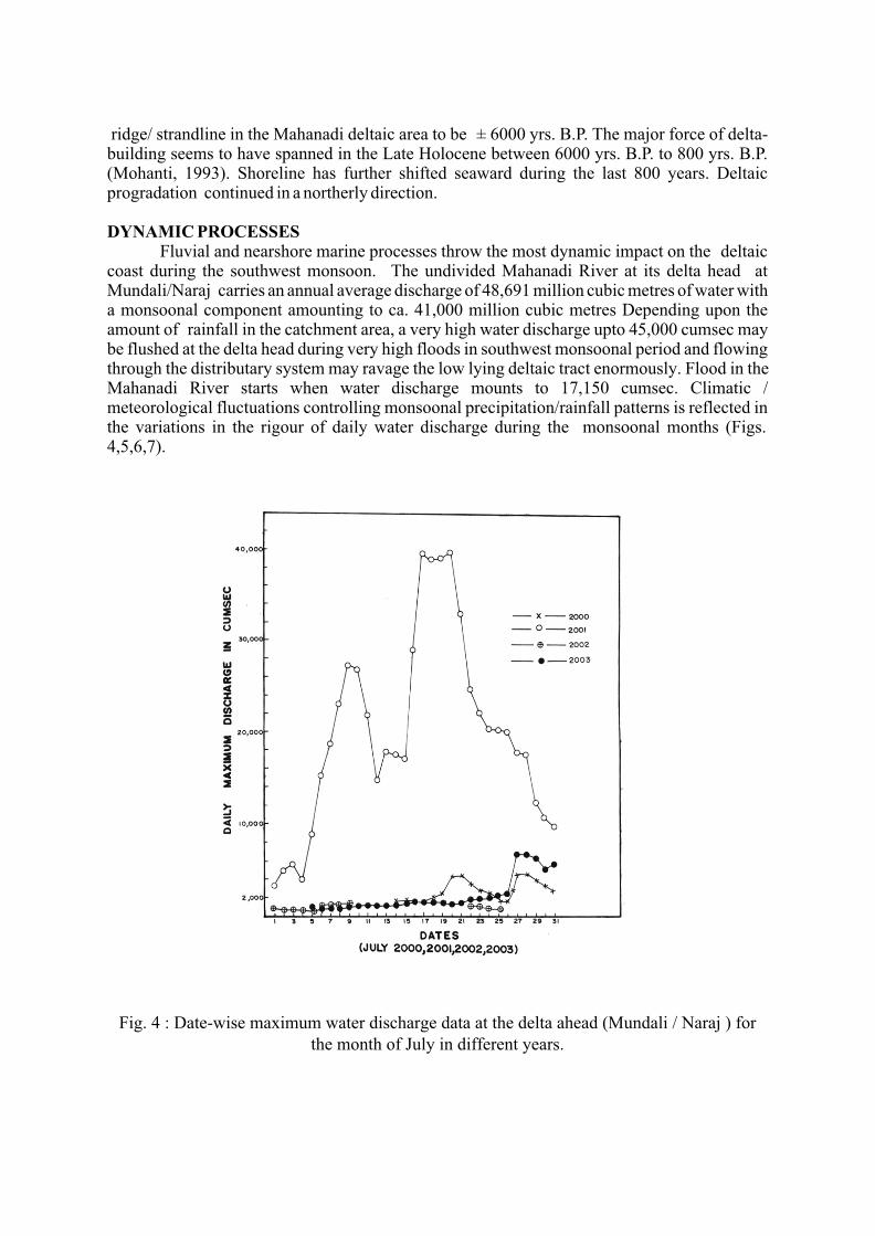
MAHANADI RIVER DELTA, EAST COAST OF INDIA : AN OVERVIEW ON EVOLUTION AND DYNAMIC PROCESSES Manmohan Mohanti Dept. of Geology, Utkal University, Bhubaneswar 751 004, India E-mail : [email protected] Manas Ranjan Swain Dept. of Geology, Nimapara College, Nimapara 752 106 Dist : - Puri, India INTRODUCTION In the land ocean interaction zone, river deltas are formed due to dynamic interaction of fluvial and marine agencies on the coastal margin. Delta building varies depending upon geologic, tectonic, geographic, climatic and environmental settings. Geometry of sediment bodies, sedimentary facies and dynamic processes vary in deltas found in different parts of the world. Major deltas in India occur on the Bay of Bengal coast on the eastern part. Mahanadi River delta is one of them. LOCATION 4 2 0 0 The Mahanadi River delta plain covers 0.9 x 10 km and lies between 85 40' : 86 45' E 0 0 5 2 and 19 40' : 20 35' N. The catchment area of the river covers 1.42 x 10 km . The climatic setting is tropical with hot and humid monsoonal climate. The sediment yield of the catchment is likely 2 to be inorder of 200-400 tons/km (Meijerink, 1982-83). With an average annual rainfall of ca. 1572 mm, over 70% is precipitated during the southwest monsoon between Mid. June to Mid. October. After traversing a long distance of over 800 km the Mahanadi River starts building up its delta plain from Naraj where the undivided Mahanadi branches forming its distributary system (Fig.1) ramifying in the delta plain area. Devi River is its principal distributary. Satellite imageries (Figs. 2,3) impress the Mahanadi River mouth and its distributary Devi River mouth in the coastal margin. Fig . 1 : Mahanadi River and its distributary system in the delta plain.
Transcript of MAHANADI RIVER DELTA, EAST COAST OF INDIA - … · MAHANADI RIVER DELTA, EAST COAST OF INDIA : AN...

MAHANADI RIVER DELTA, EAST COAST OF INDIA : AN OVERVIEWON EVOLUTION AND DYNAMIC PROCESSES
Manmohan Mohanti
Dept. of Geology, Utkal University, Bhubaneswar 751 004, IndiaE-mail : [email protected]
Manas Ranjan SwainDept. of Geology, Nimapara College, Nimapara 752 106
Dist : - Puri, India
INTRODUCTIONIn the land ocean interaction zone, river deltas are formed due to dynamic interaction of
fluvial and marine agencies on the coastal margin. Delta building varies depending upon geologic, tectonic, geographic, climatic and environmental settings. Geometry of sediment bodies, sedimentary facies and dynamic processes vary in deltas found in different parts of the world. Major deltas in India occur on the Bay of Bengal coast on the eastern part. Mahanadi River delta is one of them.
LOCATION4 2 0 0The Mahanadi River delta plain covers 0.9 x 10 km and lies between 85 40' : 86 45' E
0 0 5 2and 19 40' : 20 35' N. The catchment area of the river covers 1.42 x 10 km . The climatic setting is tropical with hot and humid monsoonal climate. The sediment yield of the catchment is likely
2to be inorder of 200-400 tons/km (Meijerink, 1982-83). With an average annual rainfall of ca. 1572 mm, over 70% is precipitated during the southwest monsoon between Mid. June to Mid. October. After traversing a long distance of over 800 km the Mahanadi River starts building up its delta plain from Naraj where the undivided Mahanadi branches forming its distributary system (Fig.1) ramifying in the delta plain area. Devi River is its principal distributary. Satellite imageries (Figs. 2,3) impress the Mahanadi River mouth and its distributary Devi River mouth in the coastal margin.
Fig . 1 : Mahanadi River and its distributary system in the delta plain.
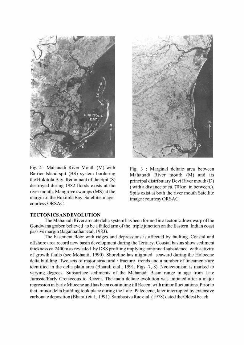
Fig 2 : Mahanadi River Mouth (M) with Barrier-Island-spit (BS) system bordering the Hukitola Bay. Remmnant of the Spit (S) destroyed during 1982 floods exists at the river mouth. Mangrove swamps (MS) at the margin of the Hukitola Bay. Satellite image : courtesy ORSAC.
Fig. 3 : Marginal deltaic area between Mahanadi River mouth (M) and its principal distributary Devi River mouth (D) ( with a distance of ca. 70 km. in between.). Spits exist at both the river mouth Satellite image : courtesy ORSAC.
TECTONICS AND EVOLUTION The Mahanadi River arcuate delta system has been formed in a tectonic downwarp of the
Gondwana graben believed to be a failed arm of the triple junction on the Eastern Indian coast passive margin (Jagannathan etal, 1983).
The basement floor with ridges and depressions is affected by faulting. Coastal and offshore area record new basin development during the Tertiary. Coastal basins show sediment thickness ca.2400m as revealed by DSS profiling implying continued subsidence with activity of growth faults (see Mohanti, 1990). Shoreline has migrated seaward during the Holocene delta building. Two sets of major structural / fracture trends and a number of lineaments are identified in the delta plain area (Bharali etal., 1991, Figs. 7, 8). Neotectonism is marked to varying degrees. Subsurface sediments of the Mahanadi Basin range in age from Late Jurassic/Early Cretaceous to Recent. The main deltaic evolution was initiated after a major regression in Early Miocene and has been continuing till Recent with minor fluctuations. Prior to that, minor delta building took place during the Late Paleocene, later interrupted by extensive carbonate deposition (Bharali etal., 1991). Sambasiva Rao etal. (1978) dated the Oldest beach
ridge/ strandline in the Mahanadi deltaic area to be ± 6000 yrs. B.P. The major force of delta-building seems to have spanned in the Late Holocene between 6000 yrs. B.P. to 800 yrs. B.P. (Mohanti, 1993). Shoreline has further shifted seaward during the last 800 years. Deltaic progradation continued in a northerly direction.
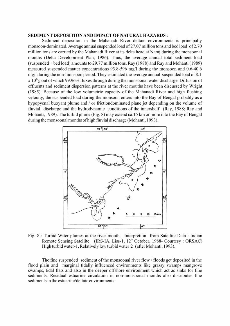
DYNAMIC PROCESSESFluvial and nearshore marine processes throw the most dynamic impact on the deltaic
coast during the southwest monsoon. The undivided Mahanadi River at its delta head at Mundali/Naraj carries an annual average discharge of 48,691 million cubic metres of water with a monsoonal component amounting to ca. 41,000 million cubic metres Depending upon the amount of rainfall in the catchment area, a very high water discharge upto 45,000 cumsec may be flushed at the delta head during very high floods in southwest monsoonal period and flowing through the distributary system may ravage the low lying deltaic tract enormously. Flood in the Mahanadi River starts when water discharge mounts to 17,150 cumsec. Climatic / meteorological fluctuations controlling monsoonal precipitation/rainfall patterns is reflected in the variations in the rigour of daily water discharge during the monsoonal months (Figs. 4,5,6,7).
Fig. 4 : Date-wise maximum water discharge data at the delta ahead (Mundali / Naraj ) for the month of July in different years.
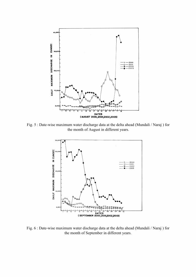
Fig. 5 : Date-wise maximum water discharge data at the delta ahead (Mundali / Naraj ) for the month of August in different years.
Fig. 6 : Date-wise maximum water discharge data at the delta ahead (Mundali / Naraj ) for the month of September in different years.

Fig. 7 : Date-wise maximum water discharge data at the delta ahead (Mundali / Naraj ) for the month of October in different years.
A discharge of 28,580 cumsec may result in damaging floods. Floods may occur more than once during one monsoonal season. An unprecedented flood occurred in the monsoon of 1982 when water discharge mounting to ca. 44.749 cumsec passed at the delta head during two days on August 31 and September 1 creating tremendous havoc in the deltaic low lands. In the recent past, the years 2001 and 2003 were marked by very high floods in the Mahanadi River. In July, 2001 (Fig.4) very high floods passed for four continuous days (July 17 to July 20) when water discharge exceeded 39,000 cumsec and the recorded highest discharge was around 40,868 cumsec. For a few days in August and September 2003, very high floods passed when water discharge fluctuated between 31,000 to 38,200 cumsec (Figs. 5,6).
Mahanadi River deltaic coast is microtidal with a mean tidal range measuring 1.29m. Tidal cycle is semi-diurnal. It is principally a wave-dominated coast during the southwest monsoonal season, while during the non-monsoonal period it is mixed wave and tide-dominated. The northeast monsoon (between December - early January) is much more milder in its dynamic activity. Southwest monsoon winds generate high waves ca.3m high or more and waves striking the shore obliquely induces a littoral / long shore drift of sands from southwest to northeast along this coast which annually moves ca., 1.5 million cubic metres of sand in the nearshore regime.
SEDIMENT DEPOSITION AND IMPACT OF NATURAL HAZARDS :Sediment deposition in the Mahanadi River deltaic environments is principally
monsoon-dominated. Average annual suspended load of 27.07 million tons and bed load of 2.70 million tons are carried by the Mahanadi River at its delta head at Naraj during the monsoonal months (Delta Development Plan, 1986). Thus, the average annual total sediment load (suspended + bed load) amounts to 29.77 million tons. Ray (1988) and Ray and Mohanti (1989) measured suspended matter concentrations 93.8-596 mg/l during the monsoon and 0.6-40.6 mg/l during the non-monsoon period. They estimated the average annual suspended load of 8.1
12x 10 g out of which 99.96% fluxes through during the monsoonal water discharge. Diffusion of effluents and sediment dispersion patterns at the river mouths have been discussed by Wright (1985). Because of the low volumetric capacity of the Mahanadi River and high flushing velocity, the suspended load during the monsoon enters into the Bay of Bengal probably as a hypopycnal buoyant plume and / or frictiondominated plane jet depending on the volume of fluvial discharge and the hydrodynamic conditions of the innershelf (Ray, 1988; Ray and Mohanti, 1989). The turbid plume (Fig. 8) may extend ca.15 km or more into the Bay of Bengal during the monsoonal months of high fluvial discharge (Mohanti, 1993).
Fig. 8 : Turbid Water plumes at the river mouth. Interpretion from Satellite Data : Indian thRemote Sensing Satellite. (IRS-IA, Liss-1, 12 October, 1988- Courtesy : ORSAC)
High turbid water-1, Relatively low turbid water 2 (after Mohanti, 1993).
The fine suspended sediment of the monsoonal river flow / floods get deposited in the flood plain and marginal tidally influenced environments like grassy swamps mangrove swamps, tidal flats and also in the deeper offshore environment which act as sinks for fine sediments. Residual estuarine circulation in non-monsoonal months also distributes fine sediments in the estuarine/deltaic environments.
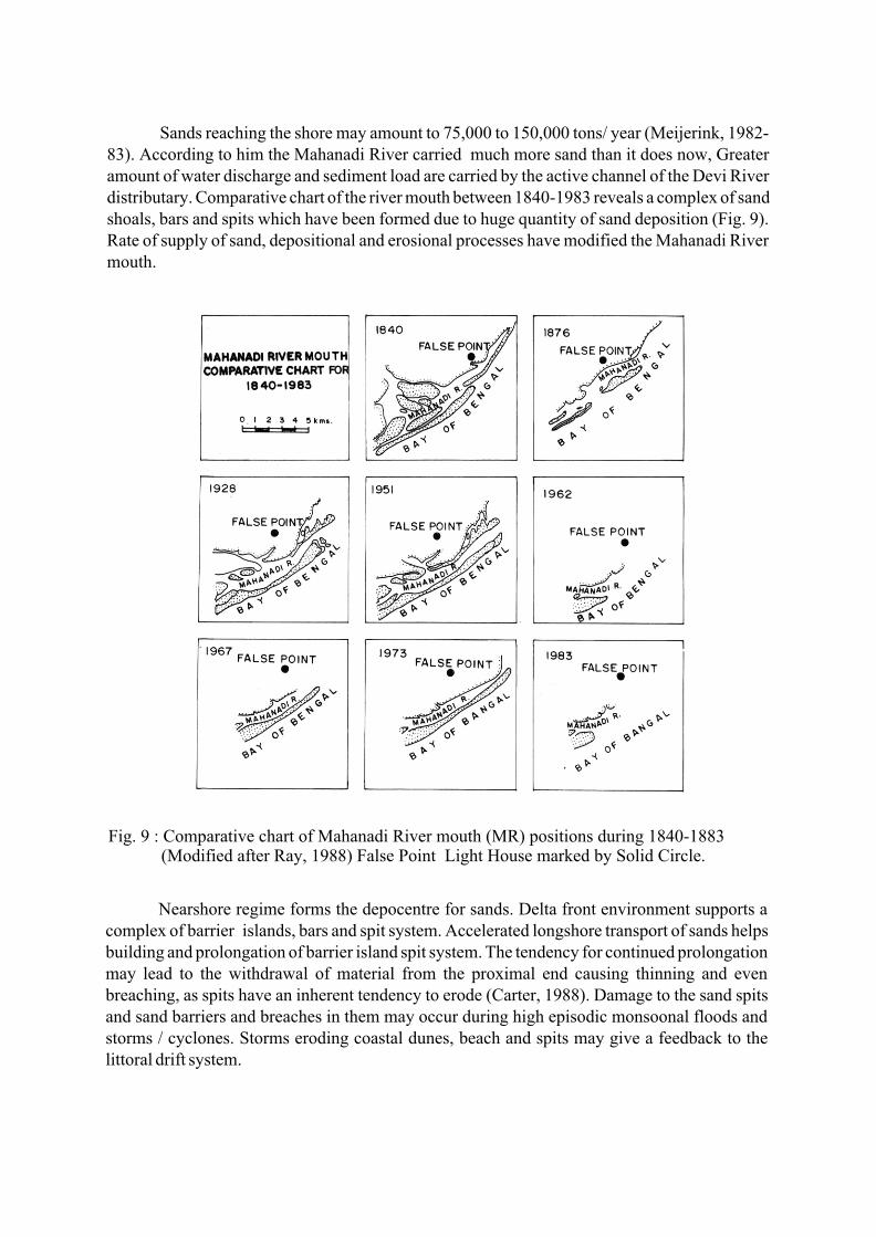
Sands reaching the shore may amount to 75,000 to 150,000 tons/ year (Meijerink, 1982-83). According to him the Mahanadi River carried much more sand than it does now, Greater amount of water discharge and sediment load are carried by the active channel of the Devi River distributary. Comparative chart of the river mouth between 1840-1983 reveals a complex of sand shoals, bars and spits which have been formed due to huge quantity of sand deposition (Fig. 9). Rate of supply of sand, depositional and erosional processes have modified the Mahanadi River mouth.
Fig. 9 : Comparative chart of Mahanadi River mouth (MR) positions during 1840-1883 (Modified after Ray, 1988) False Point Light House marked by Solid Circle.
Nearshore regime forms the depocentre for sands. Delta front environment supports a complex of barrier islands, bars and spit system. Accelerated longshore transport of sands helps building and prolongation of barrier island spit system. The tendency for continued prolongation may lead to the withdrawal of material from the proximal end causing thinning and even breaching, as spits have an inherent tendency to erode (Carter, 1988). Damage to the sand spits and sand barriers and breaches in them may occur during high episodic monsoonal floods and storms / cyclones. Storms eroding coastal dunes, beach and spits may give a feedback to the littoral drift system.
This deltaic coast is vulnerable to natural hazards like storms / cyclones apart from high river floods. These are seasonal and episodic. Consequent upon cyclones storm surge 6-7m high may enter this coast accompanied by heavy to very heavy rainfall. During pre-monsoon months of May-June and end of monsoon/post monsoon months of October-November tropical depressions are generated in the Bay of Bengal. The low-pressure belt may linger for a few days. The wind speed may be intensified further leading to stroms/severe stroms / cyclones/severe cyclones with core of hurricane winds when wind speed may reach 117 km/hour. Supercyclones rarely occur, however, when wind speed mounts to more than 200 km/hour. Recently an unprecedented Supercyclone named as "KALINGA" (Mohanti, 2000) ravaged this coast on October 29, 1999 when wind speed with a velocity ranging between 220 to 300km/hour battered the coast for long 36 hours devastating parts of this coast enormously. Storm surge 10-12m high accompanied by torrential rainfall inundated coastal low lands rendering thousands of people marooned and homeless. Satellite data after the supercyclone indicated inundation of 2097 sq. km coastal tract as well as its impact on the coastal geomorphic features manifested by severe damage to the barrier - island and spit system near the Mahanadi River mouth and Devi River mouth wherein breaches were formed and parts of it were washed away.
CONCLUDING REMARKS The delta has prograded in the seaward direction in the Holocene due to abundant supply
of sediments from the hinterland under favourable climatic / rainfall conditions, sea level adjustment, accommodation and tectonic subsidence. Delta advance and retreat will depend on the critical factor of sediment supply to the shoreface. When sediment supply to the shoreface is reduced, erosion will dominate on the shore and that will be accentuated when severe storms / cyclones hit the shore. Global climatic warming may induce frequent coastal storms/cyclones. During the last fifty years construction of a major dam (at Hirakud), a weir and barrage across the Mahanadi River have arrested sediment supply to the shoreface. Besides irregular / erratic rainfall pattern due to changes in monsoon dynamics triggered perhaps by climatic changes and increased anthropogenic activities involving rampant deforestation in the hinterland and also other human-induced factors might have also arrested sediment supply and transport to the shoreface.
Under a regime of reduced fluvial sediment supply, the littoral drift system getting a potential sediment component from fluvial sand supply may be impoverished, which may hinder nearshore aggradational processes (Mohanti, 1990). A retrograding shoreline may result under these circumstances. Looking at the depositional scenario, could it be envisioned that the Late Holocene deltaic progradation under adundant sediment supply and sea level adjustment with a net gradual seaward shifting of the shoreline, is on the critical threshold of retrogression due to reduced sediment input under natural and anthropogenic forcings and also gradual increase of sea level due to local subsidence / tectonic causes as well as eustatic causes due to global warming? If this is admitted, a staggering coastal erosion and landloss is implied (Mohanti, 1990).

The complex and inter-related factors of global warming / climate change, feedback of the catchment area, variable monsoonal precipitation influencing sediment supply and transport to the deltaic depocentre, tectonics, sea level changes and episodic catastrophic events (floods, storms/cyclones) are judged as controlling factors for the Mahanadi River delta building in time and space in the tropical setting on the east coast of India.
ACKNOWLEDGEMENTSWe are thankful to the authorities of the Water Resources Department (Lower Mahanadi
Division), Govt. of Orissa for providing the water discharge data and to the Orissa Remote Sensing Application Centre (ORSAC) for using the satellite imageries.
REFERENCES Bharali , B., Rath, S. and Sarma, R. (1991) : A brief review of Mahanadi Delta and the deltaic sediments in Mahanadi Basin. Memoirs Geological Society of India, No. 22, Bangalore, India, pp.31-49. Carter, R.W.G. (1998) : Coastal Environments An Introduction to the Physical, Ecological and Cultural systems of coastlines. Academic press, London, 617 pp.Delta Development Plan Mahanadi Delta Command Area : Geology Geomorphology and Coast Building, Vol. IV (1986) : Unpublished Report with Engineer in-chief, Irrigation, Dept., Govt. of Orissa, 90 pp.Jagannathan, C.R., Ratnam, C., Baishya, N.C. and Dasgupta, U.(1983) : Geology of the offshore Mahanadi Basin : Petroleum Asia Journal, Vol. IV (4) : pp. 101- 104.Meijerink, A.M.J. (1982-1983) : Dynamic geomorphology of the Mahanadi Delta. ITC Journal, Special Verstappen Volume, pp. 243-250.Mohanti, M. (2000) : Unprecedented Super Cyclone on the Orissa Coast of the Bay of Bengal, India. Cogeoenvironment, News Letter16 (IUGS-UNESCO), (Ed. C.J. Simpson), Torrens, Australia, pp.11-13.Mohanti, M. (1993) : Coastal processes and management of the Mahanadi River deltaic complex, East Coast of India. Proceedings Coastal Zone 93, American Society of Civil Engineers, New York, U.S.A., 75 - 90.Mohanti,M. (1990) : Sea level rise : Background, Global concern and implications for Orissa Coast, India. In : Sea level variation and its impact on coastal environment (Ed. G. Victor Rajamanickam), Tamil University Publication No. 131, Thanjavur, India, pp.197 232. Ray, S.B. (1988): Sedimentological and geochemical studies on the Mahanadi River estuary, East Coast of India. Unpublished Ph.D. thesis, Utkal University, Bhubaneswar, India, 204pp. Ray, S.B. and Mohanti, M. (1989) : Sedimentary processes in the Mahanadi River estuary, East Coast of India. Workshop on Coastal processes and coastal Quaternaries of Eastern India. Geological Survey of India, Eastern Region, Calcutta, pp. 28-29.Sambasiva Rao, M., Nageswara Rao, K. and Vaidyanadhan, R. (1978) : Morphology and evolution of Mahanadi and Brahmani Baitarani Deltas. Proceedings of Symposium on Morphology and Evolution of Landforms, Dept. Geology, Delhi University, India, pp. 241-248.Wright, L.D. (1985) : River Deltas, In : Coastal Sedimentary Environments (Ed. R.A. Davis Jr.), Springer Verlag, New York, pp. 1-76.