MA005 Rotuma - maps.mapaction.org
13
Administrative areas (1 -Divisions, 2 - Provinces, 3 -Tikina (from BoS and 4 - Old Tikina often used locally) with P- codes for each administrative level. Note - some Old Tikina cross level 3 Admin boundaries. Alternative P- codes for reporting on smaller segments of Old Tikina are shown in brackets; if not known which area is being reported, or whole OldTikina is being reported, use non-bracketed Malhaha: FJ030400401 Juju: FJ030400303 Itumuta: FJ030400101 Pejpei: FJ030400701 Itutiu: FJ030400202 Noatau: FJ030400501 Oinafa: FJ030400601 NorthernDivision: FJ03 177°30'E 177°15'E 177°E 176°45'E 176°30'E 176°15'E 12°30'S 12°45'S 13°S 13°15'S 13°30'S 450000 500000 550000 8500000 8550000 8600000 1 2 3 8 5 7 6 9 4 12 10 13 4 11 11 ´ MA005_Rotuma Data sources Fiji:Cyclone Winston- Level 4 PCODEs and Administrative Areas Including Old Tikinas Boundaries: Ministry of Lands & Mineral Resources; Bureau of Statistics P-codes: OCHA/MapAction 0 5 10 15 20 km 1: 500,000 (At A3) Produced by MapAction www.mapaction,org [email protected] The depiction and use of boundaries, names and associated data shown here do not imply endorsement or acceptance by MapAction. Supported by DFID and the Ministry of Foreign Affairs of the Netherlands. Created 25 February 2016 UTC+12:00 Map Document Projection & Datum WGS 1984 UTM Zone 60S / WGS 1984 Glide Number TC-2016-000014-FJI (Traditional/Old) Tikina Coast Province Tikina Division Central Eastern Northern Western 1 Rotuma
Transcript of MA005 Rotuma - maps.mapaction.org

Administrative areas (1 -Divisions, 2 -Provinces, 3 -Tikina (from BoS and 4 -Old Tikina often used locally) with P-codes for each administrative level.Note - some Old Tikina cross level 3Admin boundaries. Alternative P-codes for reporting on smallersegments of Old Tikina are shown inbrackets; if not known which area isbeing reported, or whole OldTikina isbeing reported, use non-bracketed
Malhaha: FJ030400401
Juju: FJ030400303
Itumuta: FJ030400101
Pejpei: FJ030400701
Itutiu: FJ030400202
Noatau: FJ030400501
Oinafa: FJ030400601
NorthernDivision:FJ03
177°30'E177°15'E177°E176°45'E176°30'E176°15'E
12°3
0'S12
°45'S
13°S
13°1
5'S13
°30'S
450000 500000 550000
8500
000
8550
000
8600
000
1
23
85 76 9
4
1210
13
4
11 11
´
MA005_Rotuma
Data sources
Fiji:Cyclone Winston-Level 4 PCODEs and
AdministrativeAreas
Including Old Tikinas
Boundaries: Ministry of Lands & MineralResources; Bureau of StatisticsP-codes: OCHA/MapAction
0 5 10 15 20km1: 500,000 (At A3)
Produced by MapAction www.mapaction,[email protected]
The depiction and use of boundaries, names andassociated data shown here do not implyendorsement or acceptance by MapAction.
Supported by DFID and the Ministry of ForeignAffairs of the Netherlands.
Created 25 February 2016 UTC+12:00Map DocumentProjection &Datum WGS 1984 UTM Zone 60S / WGS 1984
Glide Number TC-2016-000014-FJI
(Traditional/Old) TikinaCoastProvinceTikina
DivisionCentralEasternNorthernWestern
1Rotuma

Administrative areas (1 -Divisions, 2 -Provinces, 3 -Tikina (from BoS and 4 -Old Tikina often used locally) with P-codes for each administrative level.Note - some Old Tikina cross level 3Admin boundaries. Alternative P-codes for reporting on smallersegments of Old Tikina are shown inbrackets; if not known which area isbeing reported, or whole OldTikina isbeing reported, use non-bracketed
Udu: FJ030300203
Tawake: FJ030200402
(Udu: FJ030300101)
NorthernDivision:FJ03
178°45'W179°W179°15'W179°30'W179°45'W180°E
15°1
5'S15
°30'S
15°4
5'S16
°S16
°15'S
800000 850000 900000 950000
8200
000
8250
000
8300
000
1
23
85 76 9
4
1210
13
4
11 11
´
MA005_Cikobia and Vatauua
Data sources
Fiji:Cyclone Winston-Level 4 PCODEs and
AdministrativeAreas
Including Old Tikinas
Boundaries: Ministry of Lands & MineralResources; Bureau of StatisticsP-codes: OCHA/MapAction
0 5 10 15 20km1: 500,000 (At A3)
Produced by MapAction www.mapaction,[email protected]
The depiction and use of boundaries, names andassociated data shown here do not implyendorsement or acceptance by MapAction.
Supported by DFID and the Ministry of ForeignAffairs of the Netherlands.
Created 25 February 2016 UTC+12:00Map DocumentProjection &Datum WGS 1984 UTM Zone 60S / WGS 1984
Glide Number TC-2016-000014-FJI
(Traditional/Old) TikinaCoastProvinceTikina
DivisionCentralEasternNorthernWestern
2Cikobia and Vatauua
Administrative areas (1 -Divisions, 2 -Provinces, 3 -Tikina (from BoS and 4 -Old Tikina often used locally) with P-codes for each administrative level.Note - some Old Tikina cross level 3Admin boundaries. Alternative P-codes for reporting on smallersegments of Old Tikina are shown inbrackets; if not known which area isbeing reported, or whole OldTikina isbeing reported, use non-bracketed
Cakaudrove: FJ030200101Cakaudrove: FJ030200101Cakaudrove: FJ030200101Cakaudrove: FJ030200101Cakaudrove: FJ030200101Cakaudrove: FJ030200101
(Labasa: FJ030300402)
(Namuka: FJ030300303)
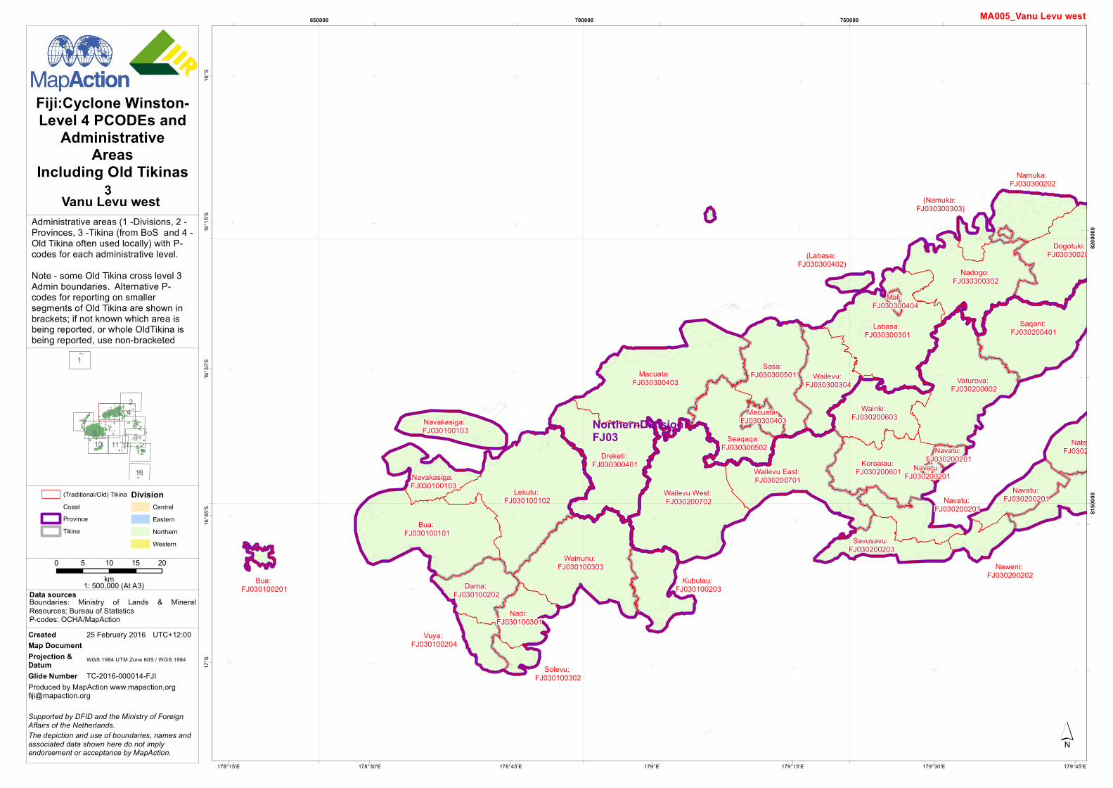
Macuata: FJ030300403
Lekutu: FJ030100102
Wailevu West: FJ030200702
Bua: FJ030100101
Labasa: FJ030300301
Wainunu: FJ030100303
Vaturova: FJ030200602
Saqani: FJ030200401
Dogotuki: FJ030300201
Dreketi: FJ030300401
Nadogo: FJ030300302
Wailevu East: FJ030200701
Sasa: FJ030300501
Koroalau: FJ030200601
Wailevu: FJ030300304
Natewa: FJ030200501
Wairiki: FJ030200603
Seaqaqa: FJ030300502
Dama: FJ030100202
Namuka: FJ030300202
Savusavu: FJ030200203
Navakasiga: FJ030100103
Kubulau: FJ030100203
Navakasiga: FJ030100103 Navatu:
FJ030200201Navatu: FJ030200201
Nadi: FJ030100301
Naweni: FJ030200202
Vuya: FJ030100204
Solevu: FJ030100302
Macuata: FJ030300403
Navatu: FJ030200201
Bua: FJ030100201
Mali: FJ030300404
Navatu: FJ030200201
NorthernDivision:FJ03
179°45'E179°30'E179°15'E179°E178°45'E178°30'E178°15'E
16°S
16°1
5'S16
°30'S
16°4
5'S17
°S
650000 700000 750000
8150
000
8200
000
1
23
85 76 9
4
1210
13
4
11 11
´
MA005_Vanu Levu west
Data sources
Fiji:Cyclone Winston-Level 4 PCODEs and
AdministrativeAreas
Including Old Tikinas
Boundaries: Ministry of Lands & MineralResources; Bureau of StatisticsP-codes: OCHA/MapAction
0 5 10 15 20km1: 500,000 (At A3)
Produced by MapAction www.mapaction,[email protected]
The depiction and use of boundaries, names andassociated data shown here do not implyendorsement or acceptance by MapAction.
Supported by DFID and the Ministry of ForeignAffairs of the Netherlands.
Created 25 February 2016 UTC+12:00Map DocumentProjection &Datum WGS 1984 UTM Zone 60S / WGS 1984
Glide Number TC-2016-000014-FJI
(Traditional/Old) TikinaCoastProvinceTikina
DivisionCentralEasternNorthernWestern
3Vanu Levu west

Administrative areas (1 -Divisions, 2 -Provinces, 3 -Tikina (from BoS and 4 -Old Tikina often used locally) with P-codes for each administrative level.Note - some Old Tikina cross level 3Admin boundaries. Alternative P-codes for reporting on smallersegments of Old Tikina are shown inbrackets; if not known which area isbeing reported, or whole OldTikina isbeing reported, use non-bracketed
Cakaudrove: FJ030200101Cakaudrove: FJ030200101Cakaudrove: FJ030200101Cakaudrove: FJ030200101Cakaudrove: FJ030200101Cakaudrove: FJ030200101
(Wainikeli: FJ030200103)
(Namuka: FJ030300303)
Labasa: FJ030300301
Vaturova: FJ030200602
Saqani: FJ030200401
Dogotuki: FJ030300201
Nadogo: FJ030300302
Vuna: FJ030200102
Koroalau: FJ030200601
Tunuloa: FJ030200502
Wainikeli: FJ030200802
Natewa: FJ030200501
Wairiki: FJ030200603
Namuka: FJ030300202
Savusavu: FJ030200203
Rabi: FJ030200301
Cakaudrove: FJ030200101
Navatu: FJ030200201Navatu:
FJ030200201
Udu: FJ030300203
Tawake: FJ030200402
Naweni: FJ030200202
Cakaudrove: FJ030200101
Laucala: FJ030200801
Navatu: FJ030200201
Wainikeli: FJ030200802
Mali: FJ030300404
(Lomaloma: FJ020200401)
Navatu: FJ030200201
NorthernDivision:FJ03
EasternDivision:FJ02
179°15'W179°30'W179°45'W180°E179°45'E179°30'E
16°S
16°1
5'S16
°30'S
16°4
5'S17
°S
800000 850000 900000
8100
000
8150
000
8200
000
1
23
85 76 9
4
1210
13
4
11 11
´
MA005_E Vanua Levu and Taveuni
Data sources
Fiji:Cyclone Winston-Level 4 PCODEs and
AdministrativeAreas
Including Old Tikinas
Boundaries: Ministry of Lands & MineralResources; Bureau of StatisticsP-codes: OCHA/MapAction
0 5 10 15 20km1: 500,000 (At A3)
Produced by MapAction www.mapaction,[email protected]
The depiction and use of boundaries, names andassociated data shown here do not implyendorsement or acceptance by MapAction.
Supported by DFID and the Ministry of ForeignAffairs of the Netherlands.
Created 25 February 2016 UTC+12:00Map DocumentProjection &Datum WGS 1984 UTM Zone 60S / WGS 1984
Glide Number TC-2016-000014-FJI
(Traditional/Old) TikinaCoastProvinceTikina
DivisionCentralEasternNorthernWestern
4E Vanua Levu and Taveuni

Administrative areas (1 -Divisions, 2 -Provinces, 3 -Tikina (from BoS and 4 -Old Tikina often used locally) with P-codes for each administrative level.Note - some Old Tikina cross level 3Admin boundaries. Alternative P-codes for reporting on smallersegments of Old Tikina are shown inbrackets; if not known which area isbeing reported, or whole OldTikina isbeing reported, use non-bracketed
Tavua: FJ040100603
Savatu: FJ040100602
Navatusila: FJ040200603
Vitogo: FJ040100703
Magodro: FJ040100201
Bulu: FJ040100101Malolo:
FJ040200301
Nalotawa: FJ040100202
Vaturu: FJ040100503
(Naviti: FJ040100401)
Qaliyalatina: FJ040100601
Vuda: FJ040100704
Sabeto: FJ040100702
Nailaga: FJ040100102
Nadi: FJ040100301
Naviti: FJ040100801
Naloto: FJ040100203
Nadrau: FJ040200601Malolo:
FJ040200301Sikituru:
FJ040100302
(Naviti: FJ040100401)
Naviti: FJ040100801
(Malolo: FJ040100701)
Waya: FJ040100402
(Malolo: FJ040100701)
(Malolo: FJ040100701)
Naviti: FJ040100801
Naviti: FJ040100801
Naviti: FJ040100801
WesternDivision:FJ04
177°45'E177°30'E177°15'E177°E176°45'E176°30'E
16°4
5'S17
°S17
°15'S
17°3
0'S17
°45'S
450000 500000 550000 600000
8050
000
8100
000
8150
000
1
23
85 76 9
4
1210
13
4
11 11
´
MA005_Yasawas and Mamanucas
Data sources
Fiji:Cyclone Winston-Level 4 PCODEs and
AdministrativeAreas
Including Old Tikinas
Boundaries: Ministry of Lands & MineralResources; Bureau of StatisticsP-codes: OCHA/MapAction
0 5 10 15 20km1: 500,000 (At A3)
Produced by MapAction www.mapaction,[email protected]
The depiction and use of boundaries, names andassociated data shown here do not implyendorsement or acceptance by MapAction.
Supported by DFID and the Ministry of ForeignAffairs of the Netherlands.
Created 25 February 2016 UTC+12:00Map DocumentProjection &Datum WGS 1984 UTM Zone 60S / WGS 1984
Glide Number TC-2016-000014-FJI
(Traditional/Old) TikinaCoastProvinceTikina
DivisionCentralEasternNorthernWestern
5Yasawas and Mamanucas

Administrative areas (1 -Divisions, 2 -Provinces, 3 -Tikina (from BoS and 4 -Old Tikina often used locally) with P-codes for each administrative level.Note - some Old Tikina cross level 3Admin boundaries. Alternative P-codes for reporting on smallersegments of Old Tikina are shown inbrackets; if not known which area isbeing reported, or whole OldTikina isbeing reported, use non-bracketed
Waidina: FJ010100402
Tavua: FJ040100603
Baravi: FJ040200101
Savatu: FJ040100602
Noikoro: FJ040200604
Navatusila: FJ040200603
Vitogo: FJ040100703
Serua: FJ010300202
Nagonenicolo: FJ010100203
Noimalu: FJ010100503Namataku:
FJ040200602
Magodro: FJ040100201
Naitasiri: FJ010100301
Bulu: FJ040100101
Batiwai: FJ010300101
Veivatuloa: FJ010100701
Nalotawa: FJ040100202
Nawaka: FJ040100501
Rukuruku: FJ040100502
Vaturu: FJ040100503
Deuba: FJ010300201
Tokaimalo: FJ040300406
Raviravi: FJ040300306
Ruwailevu: FJ040200704Wai:
FJ040200403
Momi: FJ040200402
Namosi: FJ010100601
Namalata: FJ010400301
Veinuqa: FJ010100802
Sawakasa: FJ010400503
Rewa: FJ010200501
Qaliyalatina: FJ040100601
Serua: FJ010300202
Vugalei: FJ010400304
Muaira: FJ010100501
Naqarawai: FJ010100801Qalimare:
FJ040200703
Bureivanua: FJ040300101Lawaki:
FJ040300201
(Tavua: FJ040300307)
Vuda: FJ040100704
Namena: FJ010400502
Sabeto: FJ040100702
Nuku: FJ010300102
Nuku: FJ010300102
Nailaga: FJ040100102
Nadi: FJ040100301
Nasikawa: FJ040200702
Tuva: FJ040200202
Naboubuco: FJ010100502
Waicoba: FJ040200503
Nokonoko: FJ040200501
Naloto: FJ040100203
Nakuailava: FJ040300105
Rakiraki: FJ040300305
Nadrau: FJ040200601
Conua: FJ040200102
Dawasamu: FJ010400501
Nasautoka: FJ010400403
Nasau: FJ040300203
Mataso: FJ040300103
Malomalo: FJ040200401
Nalawa: FJ040300202
Korolevu: FJ040200103
Nalaba: FJ040300403
Viria: FJ010100104
Taivugalei: FJ010400302
Verata: FJ010400303
Nakorotubu: FJ040300104
Vuna: FJ010100302Mavua:
FJ040200701
Matailobau: FJ010100202
Namena: FJ010400502
Nailuva: FJ040300401
Navuakece: FJ010100102
Sikituru: FJ040100302
Nakoro: FJ040300402
Bureiwai: FJ040300102
(Rewa: FJ010200402)
Naloto: FJ010400402
Bureta: FJ020300601
Bau: FJ010400101
Naroko: FJ040300404
Nausori: FJ010400106
Naibita: FJ010400401
Soloira: FJ010100401
(Malolo: FJ040100701)
Lutu: FJ010100201
Cuvu: FJ040200201
Waya: FJ040100402
Nakelo: FJ010400103
(Rewa: FJ010200201)
Nabaitavo: FJ010100101
Nakelo: FJ010400203
Navitilevu: FJ040300106
Rewa: FJ010200501
Wainikoroiluva: FJ010100803
Saivou: FJ040300405
Lovonivanua: FJ020300603
Bureitu: FJ010400201
(Malolo: FJ040100701)
Raviravi: FJ010200101
Navolau: FJ040300304
Namata: FJ010400105
Wailotua: FJ010400405
Moturiki: FJ020300605
Noco: FJ010200303
Vutia: FJ010200404
Nayavu: FJ010400404
Toga: FJ010200403
(Soloira: FJ010100504)
Waima: FJ010100204
Namara: FJ010400104
Sigatoka: FJ040200502
(Sawakasa: FJ010400405)
WesternDivision:FJ04
CentralDivision:FJ01
178°45'E178°30'E178°15'E178°E177°45'E177°30'E177°15'E
17°1
5'S17
°30'S
17°4
5'S18
°S18
°15'S
550000 600000 650000
8000
000
8050
000
8100
000
1
23
85 76 9
4
1210
13
4
11 11
´
MA005_Viti Levu
Data sources
Fiji:Cyclone Winston-Level 4 PCODEs and
AdministrativeAreas
Including Old Tikinas
Boundaries: Ministry of Lands & MineralResources; Bureau of StatisticsP-codes: OCHA/MapAction
0 5 10 15 20km1: 500,000 (At A3)
Produced by MapAction www.mapaction,[email protected]
The depiction and use of boundaries, names andassociated data shown here do not implyendorsement or acceptance by MapAction.
Supported by DFID and the Ministry of ForeignAffairs of the Netherlands.
Created 25 February 2016 UTC+12:00Map DocumentProjection &Datum WGS 1984 UTM Zone 60S / WGS 1984
Glide Number TC-2016-000014-FJI
(Traditional/Old) TikinaCoastProvinceTikina
DivisionCentralEasternNorthernWestern
6Viti Levu

Administrative areas (1 -Divisions, 2 -Provinces, 3 -Tikina (from BoS and 4 -Old Tikina often used locally) with P-codes for each administrative level.Note - some Old Tikina cross level 3Admin boundaries. Alternative P-codes for reporting on smallersegments of Old Tikina are shown inbrackets; if not known which area isbeing reported, or whole OldTikina isbeing reported, use non-bracketed
Waidina: FJ010100402 Naitasiri:
FJ010100301
Namalata: FJ010400301
Sawakasa: FJ010400503
Rewa: FJ010200501
Koro: FJ020300301
Vugalei: FJ010400304
Bureivanua: FJ040300101
Namena: FJ010400502
Sawaieke: FJ020300201
Nakuailava: FJ040300105 Dawasamu:
FJ010400501
Nasautoka: FJ010400403
Mataso: FJ040300103
Viria: FJ010100104
Vanuaso: FJ020300202
Taivugalei: FJ010400302
Verata: FJ010400303
Nakorotubu: FJ040300104
Vuna: FJ010100302
Matailobau: FJ010100202
Namena: FJ010400502
Navuakece: FJ010100102
Bureiwai: FJ040300102
(Rewa: FJ010200402)
Naloto: FJ010400402
Bureta: FJ020300601
Bau: FJ010400101
Nausori: FJ010400106
Naibita: FJ010400401
Soloira: FJ010100401
Lutu: FJ010100201
Nakelo: FJ010400103
Nairai: FJ020300501
(Rewa: FJ010200201)
Levuka: FJ020300602
Nabaitavo: FJ010100101
Nakelo: FJ010400203
Navitilevu: FJ040300106
Rewa: FJ010200501
Lovonivanua: FJ020300603
Bureitu: FJ010400201
Navolau: FJ040300304
Namata: FJ010400105
Wailotua: FJ010400405
Moturiki: FJ020300605
Noco: FJ010200303
Vutia: FJ010200404
Nayavu: FJ010400404
Toga: FJ010200403
(Soloira: FJ010100504)
Waima: FJ010100204
Nasinu: FJ020300605
Wakaya: FJ020300401
Batiki: FJ020300101
Wakaya: FJ020300401
Namara: FJ010400104
(Sawakasa: FJ010400405)
Lovoniwai: FJ020300604
Moturiki: FJ020300605
CentralDivision:FJ01
WesternDivision:FJ04
EasternDivision:FJ02
179°45'E179°30'E179°15'E179°E178°45'E178°30'E
17°1
5'S17
°30'S
17°4
5'S18
°S18
°15'S
650000 700000 750000 800000
8000
000
8050
000
8100
000
1
23
85 76 9
4
1210
13
4
11 11
´
MA005_Lomaiviti
Data sources
Fiji:Cyclone Winston-Level 4 PCODEs and
AdministrativeAreas
Including Old Tikinas
Boundaries: Ministry of Lands & MineralResources; Bureau of StatisticsP-codes: OCHA/MapAction
0 5 10 15 20km1: 500,000 (At A3)
Produced by MapAction www.mapaction,[email protected]
The depiction and use of boundaries, names andassociated data shown here do not implyendorsement or acceptance by MapAction.
Supported by DFID and the Ministry of ForeignAffairs of the Netherlands.
Created 25 February 2016 UTC+12:00Map DocumentProjection &Datum WGS 1984 UTM Zone 60S / WGS 1984
Glide Number TC-2016-000014-FJI
(Traditional/Old) TikinaCoastProvinceTikina
DivisionCentralEasternNorthernWestern
7Lomaiviti

Administrative areas (1 -Divisions, 2 -Provinces, 3 -Tikina (from BoS and 4 -Old Tikina often used locally) with P-codes for each administrative level.Note - some Old Tikina cross level 3Admin boundaries. Alternative P-codes for reporting on smallersegments of Old Tikina are shown inbrackets; if not known which area isbeing reported, or whole OldTikina isbeing reported, use non-bracketed
Lomaloma: FJ020200901
Cicia: FJ020200101
(Lomaloma: FJ020200401)
Laucala: FJ030200801
Nayau: FJ020201001
(Lomaloma: FJ020200501)
Lomaloma: FJ020200501
(Lomaloma: FJ020200401)
(Lomaloma: FJ020200401)
(Lomaloma: FJ020200501)Lomaloma:
FJ020200401
Lomaloma: FJ020200901
(Lomaloma: FJ020200501)
EasternDivision:FJ02
NorthernDivision:FJ03
178°30'W178°45'W179°W179°15'W179°30'W179°45'W
17°S
17°1
5'S17
°30'S
17°4
5'S18
°S
850000 900000 950000
8000
000
8050
000
8100
000
1
23
85 76 9
4
1210
13
4
11 11
´
MA005_Northern Lau
Data sources
Fiji:Cyclone Winston-Level 4 PCODEs and
AdministrativeAreas
Including Old Tikinas
Boundaries: Ministry of Lands & MineralResources; Bureau of StatisticsP-codes: OCHA/MapAction
0 5 10 15 20km1: 500,000 (At A3)
Produced by MapAction www.mapaction,[email protected]
The depiction and use of boundaries, names andassociated data shown here do not implyendorsement or acceptance by MapAction.
Supported by DFID and the Ministry of ForeignAffairs of the Netherlands.
Created 25 February 2016 UTC+12:00Map DocumentProjection &Datum WGS 1984 UTM Zone 60S / WGS 1984
Glide Number TC-2016-000014-FJI
(Traditional/Old) TikinaCoastProvinceTikina
DivisionCentralEasternNorthernWestern
8Northern Lau
Administrative areas (1 -Divisions, 2 -Provinces, 3 -Tikina (from BoS and 4 -Old Tikina often used locally) with P-codes for each administrative level.Note - some Old Tikina cross level 3Admin boundaries. Alternative P-codes for reporting on smallersegments of Old Tikina are shown inbrackets; if not known which area isbeing reported, or whole OldTikina isbeing reported, use non-bracketed
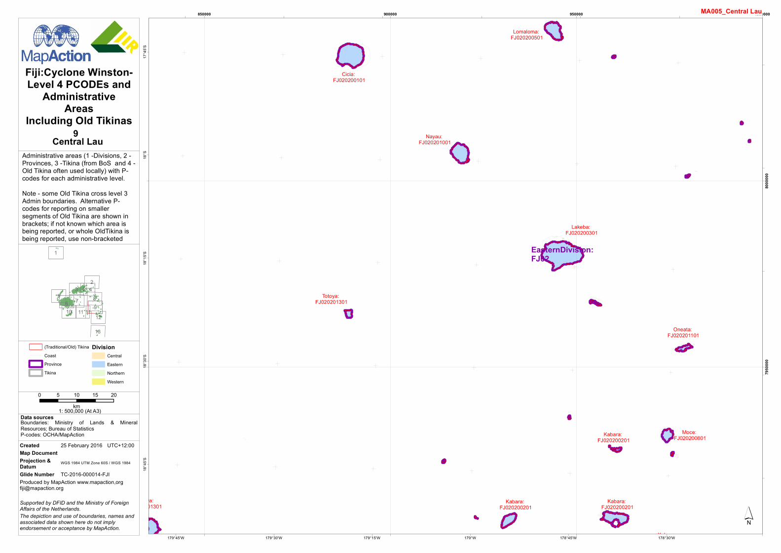
Lakeba: FJ020200301
Cicia: FJ020200101
Totoya: FJ020201301
Nayau: FJ020201001
Kabara: FJ020200201
Lomaloma: FJ020200501
Kabara: FJ020200201
Moce: FJ020200801
Oneata: FJ020201101
Totoya: FJ020201301
Kabara: FJ020200201
Kabara: FJ020200201
EasternDivision:FJ02
178°30'W178°45'W179°W179°15'W179°30'W179°45'W
17°4
5'S18
°S18
°15'S
18°3
0'S18
°45'S
850000 900000 950000 1000000
7950
000
8000
000
1
23
85 76 9
4
1210
13
4
11 11
´
MA005_Central Lau
Data sources
Fiji:Cyclone Winston-Level 4 PCODEs and
AdministrativeAreas
Including Old Tikinas
Boundaries: Ministry of Lands & MineralResources; Bureau of StatisticsP-codes: OCHA/MapAction
0 5 10 15 20km1: 500,000 (At A3)
Produced by MapAction www.mapaction,[email protected]
The depiction and use of boundaries, names andassociated data shown here do not implyendorsement or acceptance by MapAction.
Supported by DFID and the Ministry of ForeignAffairs of the Netherlands.
Created 25 February 2016 UTC+12:00Map DocumentProjection &Datum WGS 1984 UTM Zone 60S / WGS 1984
Glide Number TC-2016-000014-FJI
(Traditional/Old) TikinaCoastProvinceTikina
DivisionCentralEasternNorthernWestern
9Central Lau

Administrative areas (1 -Divisions, 2 -Provinces, 3 -Tikina (from BoS and 4 -Old Tikina often used locally) with P-codes for each administrative level.Note - some Old Tikina cross level 3Admin boundaries. Alternative P-codes for reporting on smallersegments of Old Tikina are shown inbrackets; if not known which area isbeing reported, or whole OldTikina isbeing reported, use non-bracketed
Sanima: FJ020100402
Batiwai: FJ010300101
Veivatuloa: FJ010100701
Deuba: FJ010300201
Nakasaleka: FJ020100301
Nakasaleka: FJ020100301
Naceva: FJ020100201
Serua: FJ010300202
Ravitaki: FJ020100401
Nuku: FJ010300102
Nuku: FJ010300102
Tavuki: FJ020100403
Conua: FJ040200102
Nakasaleka: FJ020100301
Korolevu: FJ040200103
Nabukelevu: FJ020100101
Yale: FJ020100202
Vatulele: FJ040200801
Cuvu: FJ040200201
(Rewa: FJ010200201)
Sawau: FJ010200102
Yawe: FJ020100102
Rewa: FJ010200501
Raviravi: FJ010200101
Noco: FJ010200303
Vutia: FJ010200404
Serua: FJ010300202
Sigatoka: FJ040200502
EasternDivision:FJ02
CentralDivision:FJ01
WesternDivision:FJ04
179°E178°45'E178°30'E178°15'E178°E177°45'E177°30'E
18°1
5'S18
°30'S
18°4
5'S19
°S19
°15'S
550000 600000 650000 700000
7900
000
7950
000
1
23
85 76 9
4
1210
13
4
11 11
´
MA005_Kadavu
Data sources
Fiji:Cyclone Winston-Level 4 PCODEs and
AdministrativeAreas
Including Old Tikinas
Boundaries: Ministry of Lands & MineralResources; Bureau of StatisticsP-codes: OCHA/MapAction
0 5 10 15 20km1: 500,000 (At A3)
Produced by MapAction www.mapaction,[email protected]
The depiction and use of boundaries, names andassociated data shown here do not implyendorsement or acceptance by MapAction.
Supported by DFID and the Ministry of ForeignAffairs of the Netherlands.
Created 25 February 2016 UTC+12:00Map DocumentProjection &Datum WGS 1984 UTM Zone 60S / WGS 1984
Glide Number TC-2016-000014-FJI
(Traditional/Old) TikinaCoastProvinceTikina
DivisionCentralEasternNorthernWestern
10Kadavu

Administrative areas (1 -Divisions, 2 -Provinces, 3 -Tikina (from BoS and 4 -Old Tikina often used locally) with P-codes for each administrative level.Note - some Old Tikina cross level 3Admin boundaries. Alternative P-codes for reporting on smallersegments of Old Tikina are shown inbrackets; if not known which area isbeing reported, or whole OldTikina isbeing reported, use non-bracketed
Matuku: FJ020200701
Totoya: FJ020201301
(Matuku: FJ020200601)
EasternDivision:FJ02
179°45'W180°E179°45'E179°30'E179°15'E179°E
18°1
5'S18
°30'S
18°4
5'S19
°S19
°15'S
700000 750000 800000 850000
7900
000
7950
000
1
23
85 76 9
4
1210
13
4
11 11
´
MA005_Moala
Data sources
Fiji:Cyclone Winston-Level 4 PCODEs and
AdministrativeAreas
Including Old Tikinas
Boundaries: Ministry of Lands & MineralResources; Bureau of StatisticsP-codes: OCHA/MapAction
0 5 10 15 20km1: 500,000 (At A3)
Produced by MapAction www.mapaction,[email protected]
The depiction and use of boundaries, names andassociated data shown here do not implyendorsement or acceptance by MapAction.
Supported by DFID and the Ministry of ForeignAffairs of the Netherlands.
Created 25 February 2016 UTC+12:00Map DocumentProjection &Datum WGS 1984 UTM Zone 60S / WGS 1984
Glide Number TC-2016-000014-FJI
(Traditional/Old) TikinaCoastProvinceTikina
DivisionCentralEasternNorthernWestern
11Moala

Administrative areas (1 -Divisions, 2 -Provinces, 3 -Tikina (from BoS and 4 -Old Tikina often used locally) with P-codes for each administrative level.Note - some Old Tikina cross level 3Admin boundaries. Alternative P-codes for reporting on smallersegments of Old Tikina are shown inbrackets; if not known which area isbeing reported, or whole OldTikina isbeing reported, use non-bracketed
Kabara: FJ020200201
Vulaga: FJ020201401
Kabara: FJ020200201
Vulaga: FJ020201401
Kabara: FJ020200201
Moce: FJ020200801
Kabara: FJ020200201
Vulaga: FJ020201401
Ono: FJ020201201
Kabara: FJ020200201
Kabara: FJ020200201
Kabara: FJ020200201
EasternDivision:FJ02
178°W178°15'W178°30'W178°45'W179°W179°15'W
18°4
5'S19
°S19
°15'S
19°3
0'S19
°45'S
900000 950000 1000000
7800
000
7850
000
7900
000
1
23
85 76 9
4
1210
13
4
11 11
´
MA005_Southern Lau
Data sources
Fiji:Cyclone Winston-Level 4 PCODEs and
AdministrativeAreas
Including Old Tikinas
Boundaries: Ministry of Lands & MineralResources; Bureau of StatisticsP-codes: OCHA/MapAction
0 5 10 15 20km1: 500,000 (At A3)
Produced by MapAction www.mapaction,[email protected]
The depiction and use of boundaries, names andassociated data shown here do not implyendorsement or acceptance by MapAction.
Supported by DFID and the Ministry of ForeignAffairs of the Netherlands.
Created 25 February 2016 UTC+12:00Map DocumentProjection &Datum WGS 1984 UTM Zone 60S / WGS 1984
Glide Number TC-2016-000014-FJI
(Traditional/Old) TikinaCoastProvinceTikina
DivisionCentralEasternNorthernWestern
12Southern Lau
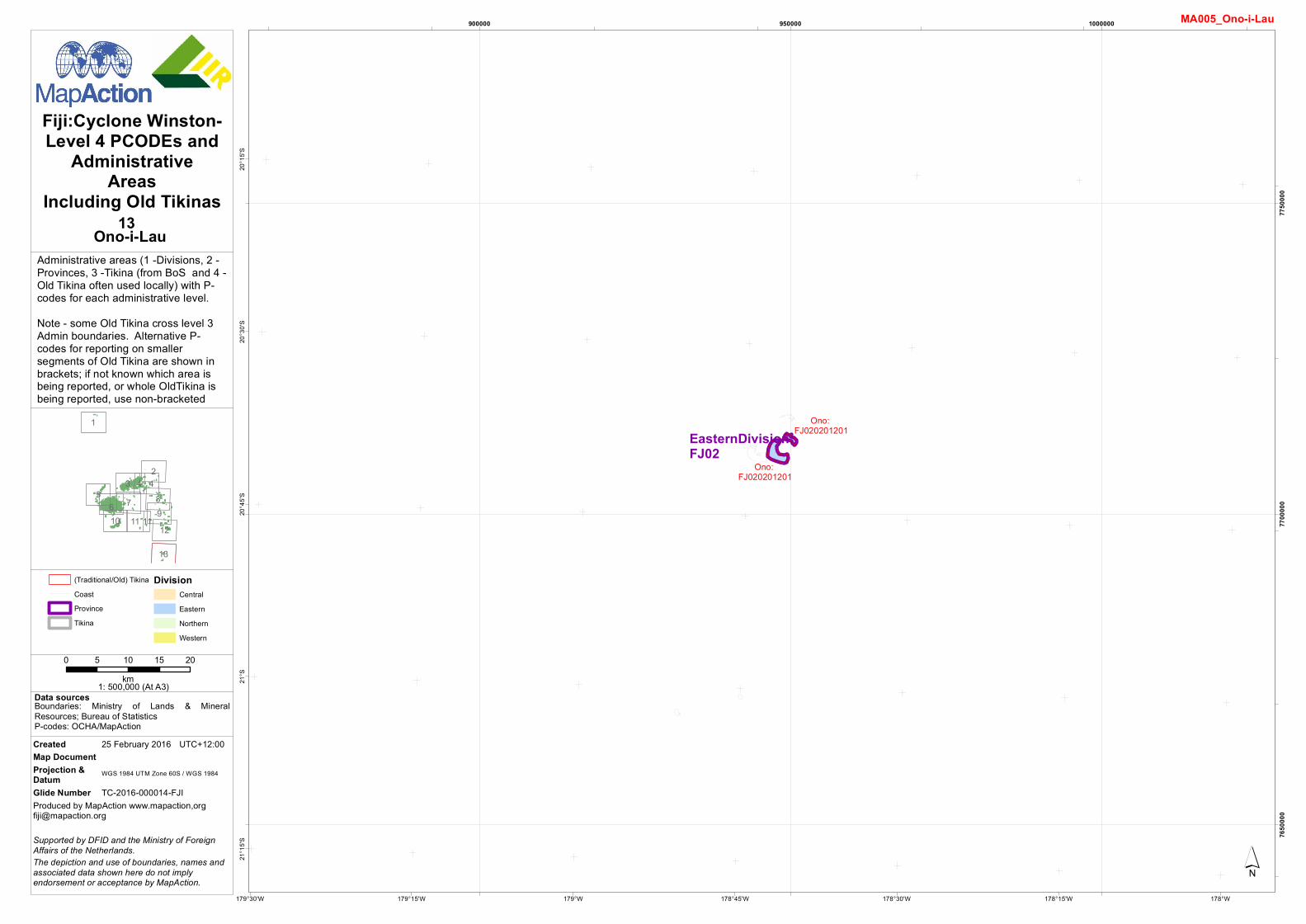
Administrative areas (1 -Divisions, 2 -Provinces, 3 -Tikina (from BoS and 4 -Old Tikina often used locally) with P-codes for each administrative level.Note - some Old Tikina cross level 3Admin boundaries. Alternative P-codes for reporting on smallersegments of Old Tikina are shown inbrackets; if not known which area isbeing reported, or whole OldTikina isbeing reported, use non-bracketed
Ono: FJ020201201
Ono: FJ020201201EasternDivision:
FJ02
178°W178°15'W178°30'W178°45'W179°W179°15'W179°30'W
20°1
5'S20
°30'S
20°4
5'S21
°S21
°15'S
900000 950000 1000000
7650
000
7700
000
7750
000
1
23
85 76 9
4
1210
13
4
11 11
´
MA005_Ono-i-Lau
Data sources
Fiji:Cyclone Winston-Level 4 PCODEs and
AdministrativeAreas
Including Old Tikinas
Boundaries: Ministry of Lands & MineralResources; Bureau of StatisticsP-codes: OCHA/MapAction
0 5 10 15 20km1: 500,000 (At A3)
Produced by MapAction www.mapaction,[email protected]
The depiction and use of boundaries, names andassociated data shown here do not implyendorsement or acceptance by MapAction.
Supported by DFID and the Ministry of ForeignAffairs of the Netherlands.
Created 25 February 2016 UTC+12:00Map DocumentProjection &Datum WGS 1984 UTM Zone 60S / WGS 1984
Glide Number TC-2016-000014-FJI
(Traditional/Old) TikinaCoastProvinceTikina
DivisionCentralEasternNorthernWestern
13Ono-i-Lau