Lucas et al., eds., 2008, Neogene Mammals. New Mexico ... · 357 Lucas et al., eds., 2008, Neogene...
8
357 Lucas et al., eds., 2008, Neogene Mammals. New Mexico Museum of Natural History and Science Bulletin 44. MAGNETIC STRATIGRAPHY OF THE EARLY TO MIDDLE MIOCENE OLCESE SAND AND ROUND MOUNTAIN SILT, KERN COUNTY, CALIFORNIA DONALD R. PROTHERO 1 , FRANCISCO SANCHEZ 1 AND LISA L. DENKE 2 1 Dept. Geology, Occidental College, Los Angeles, CA 90041; 2 T.J. Cross Engineers, Inc., 200 New Stine Road, Suite 270, Bakersfield, CA 93309 Abstract—The Olcese Sand and Round Mountain Silt, northeast of Bakersfield, California, are famous for their marine fossils, especially for the vertebrates from the Sharktooth Hill bone bed. Their ages are thought to be early to middle Miocene. Magnetic samples were taken from the 70-m thick Nickel Cliff section of the Olcese Sand, and from two sections spanning 70 m of the Round Mountain Siltstone: one at Ernst Ranch and the other along Poso Creek-Round Mountain Road. The samples were demagnetized with both alternating field and thermal demagne- tization, and produced stable remanence that passed a reversal test. The Olcese Sand is mostly normal in polarity, except for short reversed magnetozones at the middle and top of the section. Based on strontium-isotope ages ranging from 16.9-17.6 Ma, Relizian benthic foraminifera, and a fission-track date of 15.7 ± 1.7 Ma, we correlate the upper member of the Olcese Sand with Chrons C5Cn2-C5Cn3 (16.1-16.6 Ma), or latest early Miocene. Most of the Round Mountain Silt is reversed in polarity except for the very base of the section, and a short normal magnetozone in the upper third. Based on strontium-isotope isotope ages, Luisian benthic foraminifera, and Denticulopsis lauta A zone diatoms, the best correlation is with Chrons C5ADr to C5Cn1 (14.5-16.1 Ma). The entire middle part of the section, including the Sharktooth Hill bone bed, correlates with Chron C5Br (15.2-16.0 Ma). This confirms the middle Miocene (Barstovian) age of the unit, as has been suspected from the few terrestrial mammals recovered. The Olcese Sand at Nickel Cliff near the boundary fault with the Sierra foothills, shows an apparent counterclockwise tectonic rotation of about 35°, but the overlying Round Mountain Silt at more westerly locations does not. This rotation appears to be a local tectonic effect. INTRODUCTION The Cenozoic deposits of the southeastern San Joaquin Basin (Fig. 1) have long been studied for their large oil reserves (Anderson, 1911; Hoots, 1930; Addicott, 1970; Bartow and McDougall, 1984; Olson et al., 1986; Olson, 1988). They are also famous for their immense collections of fossils, especially of Miocene mollusks (Addicott, 1970), foraminifera and diatoms (Bartow and McDougall, 1984), and verte- brates (Mitchell, 1965; Savage and Barnes, 1972). In particular, the Sharktooth Hill bone bed, in the middle Miocene Round Mountain Silt, is one of the richest known vertebrate fossil deposits in the world. It yields thousands of bones representing at least 30 species of sharks (hence the name) as well as 17 species of cetaceans, 10 species of pinni- peds, 2 genera of desmostylians, sirenians (Savage and Barnes, 1972) and quite a variety of land mammals as well (Prothero et al., this volume). The underlying Olcese Sand also yields marine vertebrates and an abun- dant fauna of mollusks (Addicott, 1970). Despite the great importance of these fossils, the dating of these deposits has only recently been improved. For decades, the only method of dating them was the biostratigraphy of mollusks, which have very long biozones in the Miocene that limit precision, and occasionally are time-transgressive (Prothero, 2001). Diatom and benthic foraminiferal biozones have also been used (Barron, 1981; Bartow and McDougall, 1984), which are higher in resolution than those of mollusks. A few fission-track dates have been published (e.g., Bartow and McDougall, 1984), but the error estimates were so large (typically ± 1-2 m.y.) that precision is limited. Strontium isotope ages have been analyzed from the shell material from many of these units (Olson, 1988, Table 1), but these also give large error estimates (typically ± 1 m.y. or more), and many of the dates do not make sense in light of their stratigraphic position, sug- gesting that they have been altered by diagenesis. Thus, the age con- straints on these units are getting better, but they do not match the <100,000-year resolution of magnetic stratigraphy. GEOLOGIC BACKGROUND Two formations are the focus of the present study. The Olcese Sand (defined by Ferguson, 1941) is a friable, poorly consolidated sandy unit (seldom cemented enough to be considered a true sandstone) with interbedded siltstone and pebbly sand (Addicott, 1970; Bartow and McDougall, 1984; Olson et al., 1986; Olson, 1988). Its maximum thick- ness is about 500 m, although no exposure of the entire formation exists at the surface. The lower member consists of gray very fine-grained marine silty sandstone about 100-280 m thick at the surface, and as thick as 310 m in the subsurface (Addicott, 1970, p. 17). The middle member is composed of fine- to coarse-grained pumiceous sandstone and gravels, with abundant cross-bedding, totaling between 8 and 70 m in thickness. The highly fossiliferous upper member, which yields most of the mol- lusk and vertebrate fossils, is composed of very fine-grained marine sands. The lower and middle members of the Olcese Sand are generally poorly exposed in our study area, and not suitable for long sections of magnetic sampling. The upper member is well exposed in the Nickel Cliff section (Olson et al., 1986; Olson, 1988, fig. 8), and that was the main section sampled in this study. The Olcese Sand intertongues with the Freeman Silt at its base, and with the Round Mountain Silt that overlies it. The Olcese Sand is thickest near the eastern edge of the San Joaquin basin, and gradually pinches out within a few kilometers of its surface outcrop as it plunges down into the basin in a westerly and southerly direction. This structure is consistent with the interpretation that the Olcese Sand is composed of shallow-marine shelf sand (and may even be partly non-marine), which is also consistent with the benthic foramin- ifera recovered from the unit (Bartow and McDougall, 1984). The Olcese Sand yields a Relizian (and possibly Saucesian near the base of the unit) benthic foraminiferal assemblage. The Relizian Stage ranges from 15.5-17 Ma in age, but the subjacent Saucesian stage covers most of the early Miocene and part of the latest Oligocene (Barron and Isaacs, 2001; Prothero, 2001). The Temblor Stage molluscan assemblage ranges from 23 to 9 Ma, spanning almost the entire Miocene (Prothero,
Transcript of Lucas et al., eds., 2008, Neogene Mammals. New Mexico ... · 357 Lucas et al., eds., 2008, Neogene...

357Lucas et al., eds., 2008, Neogene Mammals. New Mexico Museum of Natural History and Science Bulletin 44.
MAGNETIC STRATIGRAPHY OF THE EARLY TO MIDDLE MIOCENE OLCESESAND AND ROUND MOUNTAIN SILT, KERN COUNTY, CALIFORNIA
DONALD R. PROTHERO1, FRANCISCO SANCHEZ1 AND LISA L. DENKE2
1 Dept. Geology, Occidental College, Los Angeles, CA 90041;2 T.J. Cross Engineers, Inc., 200 New Stine Road, Suite 270, Bakersfield, CA 93309
Abstract—The Olcese Sand and Round Mountain Silt, northeast of Bakersfield, California, are famous for theirmarine fossils, especially for the vertebrates from the Sharktooth Hill bone bed. Their ages are thought to be earlyto middle Miocene. Magnetic samples were taken from the 70-m thick Nickel Cliff section of the Olcese Sand, andfrom two sections spanning 70 m of the Round Mountain Siltstone: one at Ernst Ranch and the other along PosoCreek-Round Mountain Road. The samples were demagnetized with both alternating field and thermal demagne-tization, and produced stable remanence that passed a reversal test. The Olcese Sand is mostly normal in polarity,except for short reversed magnetozones at the middle and top of the section. Based on strontium-isotope agesranging from 16.9-17.6 Ma, Relizian benthic foraminifera, and a fission-track date of 15.7 ± 1.7 Ma, we correlatethe upper member of the Olcese Sand with Chrons C5Cn2-C5Cn3 (16.1-16.6 Ma), or latest early Miocene. Mostof the Round Mountain Silt is reversed in polarity except for the very base of the section, and a short normalmagnetozone in the upper third. Based on strontium-isotope isotope ages, Luisian benthic foraminifera, andDenticulopsis lauta A zone diatoms, the best correlation is with Chrons C5ADr to C5Cn1 (14.5-16.1 Ma). Theentire middle part of the section, including the Sharktooth Hill bone bed, correlates with Chron C5Br (15.2-16.0Ma). This confirms the middle Miocene (Barstovian) age of the unit, as has been suspected from the few terrestrialmammals recovered. The Olcese Sand at Nickel Cliff near the boundary fault with the Sierra foothills, shows anapparent counterclockwise tectonic rotation of about 35°, but the overlying Round Mountain Silt at more westerlylocations does not. This rotation appears to be a local tectonic effect.
INTRODUCTION
The Cenozoic deposits of the southeastern San Joaquin Basin(Fig. 1) have long been studied for their large oil reserves (Anderson,1911; Hoots, 1930; Addicott, 1970; Bartow and McDougall, 1984; Olsonet al., 1986; Olson, 1988). They are also famous for their immensecollections of fossils, especially of Miocene mollusks (Addicott, 1970),foraminifera and diatoms (Bartow and McDougall, 1984), and verte-brates (Mitchell, 1965; Savage and Barnes, 1972). In particular, theSharktooth Hill bone bed, in the middle Miocene Round Mountain Silt,is one of the richest known vertebrate fossil deposits in the world. Ityields thousands of bones representing at least 30 species of sharks(hence the name) as well as 17 species of cetaceans, 10 species of pinni-peds, 2 genera of desmostylians, sirenians (Savage and Barnes, 1972) andquite a variety of land mammals as well (Prothero et al., this volume).The underlying Olcese Sand also yields marine vertebrates and an abun-dant fauna of mollusks (Addicott, 1970).
Despite the great importance of these fossils, the dating of thesedeposits has only recently been improved. For decades, the only methodof dating them was the biostratigraphy of mollusks, which have verylong biozones in the Miocene that limit precision, and occasionally aretime-transgressive (Prothero, 2001). Diatom and benthic foraminiferalbiozones have also been used (Barron, 1981; Bartow and McDougall,1984), which are higher in resolution than those of mollusks. A fewfission-track dates have been published (e.g., Bartow and McDougall,1984), but the error estimates were so large (typically ± 1-2 m.y.) thatprecision is limited. Strontium isotope ages have been analyzed from theshell material from many of these units (Olson, 1988, Table 1), but thesealso give large error estimates (typically ± 1 m.y. or more), and many ofthe dates do not make sense in light of their stratigraphic position, sug-gesting that they have been altered by diagenesis. Thus, the age con-straints on these units are getting better, but they do not match the<100,000-year resolution of magnetic stratigraphy.
GEOLOGIC BACKGROUND
Two formations are the focus of the present study. The OlceseSand (defined by Ferguson, 1941) is a friable, poorly consolidated sandyunit (seldom cemented enough to be considered a true sandstone) withinterbedded siltstone and pebbly sand (Addicott, 1970; Bartow andMcDougall, 1984; Olson et al., 1986; Olson, 1988). Its maximum thick-ness is about 500 m, although no exposure of the entire formation existsat the surface. The lower member consists of gray very fine-grainedmarine silty sandstone about 100-280 m thick at the surface, and as thickas 310 m in the subsurface (Addicott, 1970, p. 17). The middle memberis composed of fine- to coarse-grained pumiceous sandstone and gravels,with abundant cross-bedding, totaling between 8 and 70 m in thickness.The highly fossiliferous upper member, which yields most of the mol-lusk and vertebrate fossils, is composed of very fine-grained marinesands. The lower and middle members of the Olcese Sand are generallypoorly exposed in our study area, and not suitable for long sections ofmagnetic sampling. The upper member is well exposed in the Nickel Cliffsection (Olson et al., 1986; Olson, 1988, fig. 8), and that was the mainsection sampled in this study. The Olcese Sand intertongues with theFreeman Silt at its base, and with the Round Mountain Silt that overliesit. The Olcese Sand is thickest near the eastern edge of the San Joaquinbasin, and gradually pinches out within a few kilometers of its surfaceoutcrop as it plunges down into the basin in a westerly and southerlydirection. This structure is consistent with the interpretation that theOlcese Sand is composed of shallow-marine shelf sand (and may even bepartly non-marine), which is also consistent with the benthic foramin-ifera recovered from the unit (Bartow and McDougall, 1984).
The Olcese Sand yields a Relizian (and possibly Saucesian nearthe base of the unit) benthic foraminiferal assemblage. The Relizian Stageranges from 15.5-17 Ma in age, but the subjacent Saucesian stage coversmost of the early Miocene and part of the latest Oligocene (Barron andIsaacs, 2001; Prothero, 2001). The Temblor Stage molluscan assemblageranges from 23 to 9 Ma, spanning almost the entire Miocene (Prothero,
358
2001). Addicott (1970, p. 18) described a cross-bedded pumiceous sand-stone from the middle member that yielded a fission-track date of 15.5 ±1.7 Ma (Bartow and McDougall, 1984, p. J23). Unfortunately, the pre-cise stratigraphic position of this sample was never recorded, and theerror estimate is large. Several strontium-isotope ages were reported byOlson (1988, table 1), most of which range from 16.8 ± 1 Ma to 17.7 ±1 Ma. However, a few ages were as old as 19 ± 1 Ma, which conflictswith the age estimates on the underlying units, as well as the benthicforaminifera and the fission-track date.
The other unit sampled in this study is the Round Mountain Silt,which overlies and interfingers with the Olcese Sand. First named byDiepenbrock (1933), it was redefined by Addicott (1970). It is overlainunconformably by the Chanac Formation or “Santa Margarita Forma-tion” in the Kern River area, and in the western subsurface, it is overlainconformably by the Fruitvale Shale (Bartow and McDougall, 1984). TheRound Mountain Silt is friable and poorly consolidated, so it is really asilt and not a true siltstone. It consists mainly of greenish-gray, mica-ceous, clayey-sandy silt with local white diatomite layers. Bartow andMcDougall (1984, p. J28) report a total thickness of 400 m in the sub-surface, although no continuous surface exposures exceed 100 m in thick-ness. A 55-m thick diatomaceous unit is found near the base of theformation (Olson, 1988), which shifts upward in the section as the totalthickness of the unit pinches out. The Sharktooth Hill bone bed is foundabout 33 m above the diatomaceous layer in some sections, placing it inthe middle to upper part of the section.
The Round Mountain Silt yields a Luisian benthic foraminiferalfauna, which ranges between 14 and 15.5 Ma in age (Barron and Isaacs,2001; Prothero, 2001). The diatomite yields diatoms characteristic of theDenticulopsis lauta A zone (Barron, 1981; Barron, in Bartow andMcDougall, 1984), which is between 15 and 16 Ma in age (Barron,1981). The Temblor Stage mollusks, as noted above, span almost theentire Miocene, and are of little use for precise correlation. Olson (1988,table 1) obtained strontium-isotope ages on a number of shells, withmost samples ranging from 15.5 ± 1 Ma to 16.3 ± 1 Ma. There were afew aberrantly old dates of 17.8 ± 1 Ma and 18.0 ± 1 Ma, which are olderthan most of the dates from the underlying Olcese Sand, and also olderthan the biostratigraphic age constraints of the foraminifera and diatoms.
FIGURE 1.A, Location map of the outcrop of the Round Mountain andOlcese Formations. B, Detail of the area spanning the adjacent corners ofthe Knob Hill, Oil Center, and Rio Bravo Ranch 7.5’ topographic quadrangles,Kern County, California, showing position of magnetic sections and sites(Courtesy N. Pyenson).
TABLE 1. Paleomagnetic data from the Olcese and Round MountainFormations. D = declination; I = inclination; K = precision parameter; 95indicates ellipse of 95% confidence around mean.

359
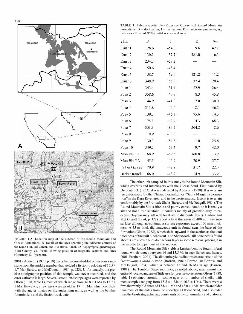
FIGURE 2. Orthogonal demagnetization (“Zijderveld”) plots of representative samples. Solid squares indicate declination (horizontal component); opensquares indicate inclination (vertical component). First step is NRM, followed by AF steps of 25, 50, and 100 Gauss, then thermal steps from 200° to 630°Cin 50°C increments. Each division equals 10-5 emu.
360
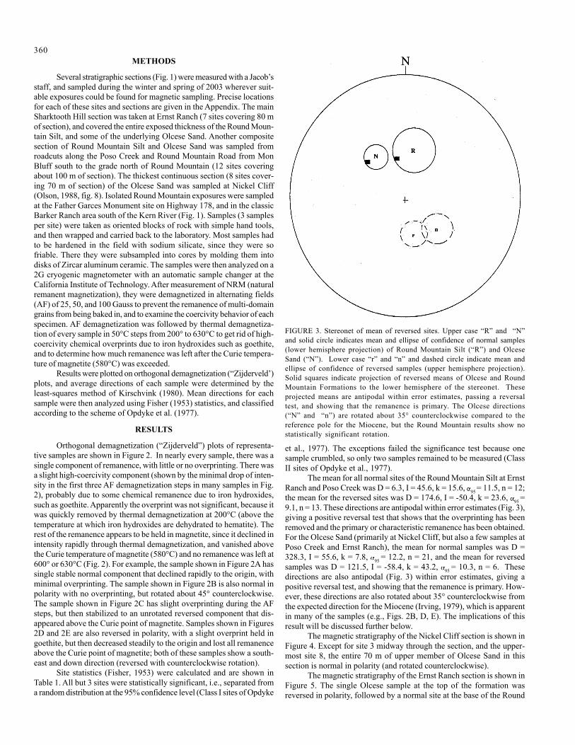
FIGURE 3. Stereonet of mean of reversed sites. Upper case “R” and “N”and solid circle indicates mean and ellipse of confidence of normal samples(lower hemisphere projection) of Round Mountain Silt (“R”) and OlceseSand (“N”). Lower case “r” and “n” and dashed circle indicate mean andellipse of confidence of reversed samples (upper hemisphere projection).Solid squares indicate projection of reversed means of Olcese and RoundMountain Formations to the lower hemisphere of the stereonet. Theseprojected means are antipodal within error estimates, passing a reversaltest, and showing that the remanence is primary. The Olcese directions(“N” and “n”) are rotated about 35° counterclockwise compared to thereference pole for the Miocene, but the Round Mountain results show nostatistically significant rotation.
METHODS
Several stratigraphic sections (Fig. 1) were measured with a Jacob’sstaff, and sampled during the winter and spring of 2003 wherever suit-able exposures could be found for magnetic sampling. Precise locationsfor each of these sites and sections are given in the Appendix. The mainSharktooth Hill section was taken at Ernst Ranch (7 sites covering 80 mof section), and covered the entire exposed thickness of the Round Moun-tain Silt, and some of the underlying Olcese Sand. Another compositesection of Round Mountain Silt and Olcese Sand was sampled fromroadcuts along the Poso Creek and Round Mountain Road from MonBluff south to the grade north of Round Mountain (12 sites coveringabout 100 m of section). The thickest continuous section (8 sites cover-ing 70 m of section) of the Olcese Sand was sampled at Nickel Cliff(Olson, 1988, fig. 8). Isolated Round Mountain exposures were sampledat the Father Garces Monument site on Highway 178, and in the classicBarker Ranch area south of the Kern River (Fig. 1). Samples (3 samplesper site) were taken as oriented blocks of rock with simple hand tools,and then wrapped and carried back to the laboratory. Most samples hadto be hardened in the field with sodium silicate, since they were sofriable. There they were subsampled into cores by molding them intodisks of Zircar aluminum ceramic. The samples were then analyzed on a2G cryogenic magnetometer with an automatic sample changer at theCalifornia Institute of Technology. After measurement of NRM (naturalremanent magnetization), they were demagnetized in alternating fields(AF) of 25, 50, and 100 Gauss to prevent the remanence of multi-domaingrains from being baked in, and to examine the coercivity behavior of eachspecimen. AF demagnetization was followed by thermal demagnetiza-tion of every sample in 50°C steps from 200° to 630°C to get rid of high-coercivity chemical overprints due to iron hydroxides such as goethite,and to determine how much remanence was left after the Curie tempera-ture of magnetite (580°C) was exceeded.
Results were plotted on orthogonal demagnetization (“Zijderveld’)plots, and average directions of each sample were determined by theleast-squares method of Kirschvink (1980). Mean directions for eachsample were then analyzed using Fisher (1953) statistics, and classifiedaccording to the scheme of Opdyke et al. (1977).
RESULTS
Orthogonal demagnetization (“Zijderveld”) plots of representa-tive samples are shown in Figure 2. In nearly every sample, there was asingle component of remanence, with little or no overprinting. There wasa slight high-coercivity component (shown by the minimal drop of inten-sity in the first three AF demagnetization steps in many samples in Fig.2), probably due to some chemical remanence due to iron hydroxides,such as goethite. Apparently the overprint was not significant, because itwas quickly removed by thermal demagnetization at 200°C (above thetemperature at which iron hydroxides are dehydrated to hematite). Therest of the remanence appears to be held in magnetite, since it declined inintensity rapidly through thermal demagnetization, and vanished abovethe Curie temperature of magnetite (580°C) and no remanence was left at600° or 630°C (Fig. 2). For example, the sample shown in Figure 2A hassingle stable normal component that declined rapidly to the origin, withminimal overprinting. The sample shown in Figure 2B is also normal inpolarity with no overprinting, but rotated about 45° counterclockwise.The sample shown in Figure 2C has slight overprinting during the AFsteps, but then stabilized to an unrotated reversed component that dis-appeared above the Curie point of magnetite. Samples shown in Figures2D and 2E are also reversed in polarity, with a slight overprint held ingoethite, but then decreased steadily to the origin and lost all remanenceabove the Curie point of magnetite; both of these samples show a south-east and down direction (reversed with counterclockwise rotation).
Site statistics (Fisher, 1953) were calculated and are shown inTable 1. All but 3 sites were statistically significant, i.e., separated froma random distribution at the 95% confidence level (Class I sites of Opdyke
et al., 1977). The exceptions failed the significance test because onesample crumbled, so only two samples remained to be measured (ClassII sites of Opdyke et al., 1977).
The mean for all normal sites of the Round Mountain Silt at ErnstRanch and Poso Creek was D = 6.3, I = 45.6, k = 15.6, 95 = 11.5, n = 12;the mean for the reversed sites was D = 174.6, I = -50.4, k = 23.6, 95 =9.1, n = 13. These directions are antipodal within error estimates (Fig. 3),giving a positive reversal test that shows that the overprinting has beenremoved and the primary or characteristic remanence has been obtained.For the Olcese Sand (primarily at Nickel Cliff, but also a few samples atPoso Creek and Ernst Ranch), the mean for normal samples was D =328.3, I = 55.6, k = 7.8, 95 = 12.2, n = 21, and the mean for reversedsamples was D = 121.5, I = -58.4, k = 43.2, 95 = 10.3, n = 6. Thesedirections are also antipodal (Fig. 3) within error estimates, giving apositive reversal test, and showing that the remanence is primary. How-ever, these directions are also rotated about 35° counterclockwise fromthe expected direction for the Miocene (Irving, 1979), which is apparentin many of the samples (e.g., Figs. 2B, D, E). The implications of thisresult will be discussed further below.
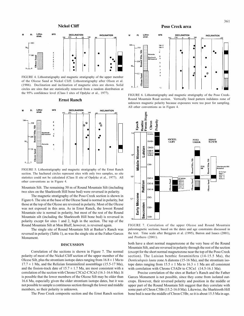
The magnetic stratigraphy of the Nickel Cliff section is shown inFigure 4. Except for site 3 midway through the section, and the upper-most site 8, the entire 70 m of upper member of Olcese Sand in thissection is normal in polarity (and rotated counterclockwise).
The magnetic stratigraphy of the Ernst Ranch section is shown inFigure 5. The single Olcese sample at the top of the formation wasreversed in polarity, followed by a normal site at the base of the Round
361
Mountain Silt. The remaining 50 m of Round Mountain Silt (includingtwo sites on the Sharktooth Hill bone bed) were reversed in polarity.
The magnetic stratigraphy of the Poso Creek section is shown inFigure 6. The site at the base of the Olcese Sand is normal in polarity, butthose at the top of the Olcese are reversed in polarity. Most of the Olcesewas not exposed in this area. As in Ernst Ranch, the lowest RoundMountain site is normal in polarity, but most of the rest of the RoundMountain silt (including the Sharktooth Hill bone bed) is reversed inpolarity except for sites 1 and 2, high in the section. The top of theRound Mountain Silt at Mon Bluff, however, is reversed again.
The single site of Round Mountain Silt at Barker’s Ranch wasreversed in polarity (Table 1), as was the single site at the Father GarcesMonument.
DISCUSSION
Correlation of the sections is shown in Figure 7. The normalpolarity of most of the Nickel Cliff section of the upper member of theOlcese Silt, plus the strontium isotope dates ranging from 16.8 ± 1 Ma to17.7 ± 1 Ma, and the Relizian foraminiferal assemblage (15.5-17 Ma),and the fission-track date of 15.7 ± 1.7 Ma, are most consistent with acorrelation of the section with Chrons C5Cn2-C5Cn3 (16.1-16.6 Ma). Itis possible that the lower members of the Olcese Silt may be older than16.6 Ma, especially given the older strontium isotope dates, but it wasnot possible to sample a continuous section through the lower and middlemembers, so their polarity is unknown.
The Poso Creek composite section and the Ernst Ranch section
both have a short normal magnetozone at the very base of the RoundMountain Silt, and are reversed in polarity through the rest of the section(except for the short normal magnetozone near the top of the Poso Creeksection). The Luisian benthic foraminifera (14-15.5 Ma), theDenticulopsis lauta zone A diatoms (15-16 Ma), and the strontium iso-tope dates ranging from 15.5 ± 1 Ma to 16.3 ± 1 Ma are all consistentwith correlation with Chrons C5ADr to C5Cn1 (14.5-16.1 Ma).
Precise correlation of the sites at Barker’s Ranch and the FatherGarces Monument is not possible, since they come from isolated out-crops. However, their reversed polarity and position in the middle orupper part of the Round Mountain Silt suggest that they correlate withsome part of Chron C5Br (15.2-16.0 Ma). Likewise, the Sharktooth Hillbone bed is near the middle of Chron C5Br, so it is about 15.5 Ma in age.
FIGURE 4. Lithostratigraphy and magnetic stratigraphy of the upper memberof the Olcese Sand at Nickel Cliff. Lithostratigraphy after Olson et al.(1986). Declination and inclination of magnetic sites are shown. Solidcircles are sites that are statistically removed from a random distribution atthe 95% confidence level (Class I sites of Opdyke et al., 1977).
FIGURE 5. Lithostratigraphy and magnetic stratigraphy of the Ernst Ranchsection. The hachured circles represent sites with only two samples, so sitestatistics could not be calculated (Class II site of Opdyke et al., 1977). Allother conventions as in Figure 4.
FIGURE 6. Lithostratigraphy and magnetic stratigraphy of the Poso Creek-Round Mountain Road section. Vertically lined pattern indidates zone ofunknown magnetic polarity because exposures were too poor for sampling.All other conventions as in Figure 4.
FIGURE 7. Correlation of the upper Olcese and Round Mountainpaleomagnetic sections, based on the dates and age constraints discussed inthe text. Time scale after Berggren et al. (1995), Barron and Isaacs (2001),and Prothero (2001).

362The apparent 35° counterclockwise rotation of the Olcese results
is surprising, given that the overlying Round Mountain Silt is not rotated(Fig. 3). This rotation could be due to the fact that most of the Olcesesamples came from Nickel Cliff, which is the farthest east of all thelocalities sampled, and closest to the boundary fault with the Sierrafoothills (Fig. 1). However, the literature shows that magnetic directionsand rotations are highly variable in the region. Kanter and McWilliams(1982) showed both unrotated and counterclockwise rotated results (someonly a few kilometers apart) on the lower Miocene (16.5-17 Ma) KinnickFormation, in the southern Tehachapi Mountains, only 60 km southeastof Sharktooth Hill. Coles et al. (1997), however, found no rotation on themiddle Miocene (14.5-16.5 Ma) Bopesta Formation, which overlies theKinnick Formation in the Tehachapis. Clearly, the middle Miocene rota-tions in this region are highly variable from one tectonic block to another.The rotation of the Olcese Sand at Nickel Cliff is probably anotherexample of this local tectonic effect, especially given its proximity to theboundary fault with the Sierran foothills.
CONCLUSIONS
The upper member of the Olcese Sand northeast of Bakersfieldcorrelates with Chrons C5Cn2-C5Cn3 (16.1-16.6 Ma), so it is late early
Miocene in age. Although the lower and middle members of the OlceseSand were too poorly exposed in our study area for magnetic sampling,they may be as old as 18-19 Ma based on their strontium isotope ages.The exposed outcrops of the Round Mountain Silt are correlated withChrons C5ADr to C5Cn1 (14.5-16.1 Ma), so they are early middleMiocene in age. The Round Mountain Silt showed no evidence of tec-tonic rotation, but the Olcese Sand at Nickel Cliff was rotated 35° coun-terclockwise. This appears to be a local tectonic effect, however, sincerotations of middle Miocene rocks in the southern Sierras and Tehachapisare highly variable throughout the region.
ACKNOWLEDGMENTS
We thank Paula Dold, Matthew Liter, Josh Ludtke, and JingmaiO’Connor for help with sampling, and Josh Ludtke for help with the labwork. We thank Dr. Joseph Kirschvink for access to the Caltechpaleomagnetics lab. We thank Larry Barnes, and Ben Nafus for help withthe stratigraphy and geology. We thank the late Bob Ernst and the RioBravo Ranch for access to the land. We thank Steve Graham, Rob Negrini,Ben Nafus, Hilary Olson, Nick Pyenson, and Spencer Lucas for helpfulcomments or for reviews of this paper. This research was supported bygrants to Prothero by the Donors of the Petroleum Research Fund of theAmerican Chemical Society, and by NSF grant 00-00174.
REFERENCES
Addicott, W.O., 1970, Miocene gastropods and biostratigraphy of the KernRiver area, California: U.S. Geological Survey Professional Paper, v.642, p. 1-174.
Anderson, F.M., 1911, The Neocene deposits of Kern River, California, andthe Temblor Basin: California Academy of Sciences Proceedings, ser. 4,v. 3, no. 3, p. 73-148.
Barron, J.A., 1981, Late Cenozoic diatom biostratigraphy andpaleoceanography of middle-latitude eastern north Pacific, Deep-SeaDrilling Leg 63: Initial Reports of the Deep-Sea Drilling Project, v. 63,p. 507-538.
Barron, J.A., and Isaacs, C.M., 2001, Updated chronostratigraphic frame-work for the California Miocene; in Isaacs, C.M., and Rulkötter, J, eds.,The Monterey Formation: From Rocks to Molecules: New York, Co-lumbia University Press, pp. 393-395.
Bartow, J.A., and McDougall, K., 1984, Tertiary stratigraphy of the south-eastern San Joaquin Valley, California: U.S. Geological Survey Bulletin,v. 1529-J, p. J1-J41.
Berggren, W.A., Kent, D. V., Swisher, C. C., III, and Aubry, M.-P., 1995, Arevised Cenozoic geochronology and chronostratigraphy: SEPM Spe-cial Publication, v. 54, p. 129-212.
Coles, S., Prothero, D.R., Quinn, J.P., and Swisher, C.C., III, 1997, Mag-netic stratigraphy of the middle Miocene Bopesta Formation, southernSierra Nevadas, Kern County, California: Pacific Section SEPM SpecialPublication, v. 82, p. 21-34.
Diepenbrock, A. 1933. Mount Poso oil field. California Oil Fields, v. 19, no.2, p. 4-35.
Ferguson, G.C., 1941, Correlation of oil field formations on the east side ofSan Joaquin Valley: California Division of Mines Bulletin, v. 118, pt. 2,p. 239-246.
Fisher, R. A., 1953, Dispersion on a sphere: Proceedings of the RoyalSociety, v. A217, p. 295-305.
Hoots, H.W., 1930, Geology and oil resources along the southern border ofSan Joaquin Valley, California: U.S. Geological Survey Bulletin, v. 812, p.243-332.
Irving, E., 1979, Paleopoles and paleolatitudes of North America and specu-lation about displaced terranes: Canadian Journal of Earth Sciences, v.16, p. 669-694.
Kanter, L.R., and McWilliams, M.O., 1982, Rotation of the southernmostSierra Nevada, California: Journal of Geophysical Research, v. 87, no.B5, pp. 3819-3830.
Kirschvink, J. L., 1980, The least-squares line and plane and the analysis ofpaleomagnetic data: examples from Siberia and Morocco: GeophysicalJournal of the Royal Astronomical Society, v. 62, p. 699-718.
Mitchell, E., 1965, History of Research at Sharktooth Hill, Kern County,California: Special Publication of the Kern County Historical Societyand the County of Kern, pp. 1-45.
Olson, H.C., 1988, Oligocene-middle Miocene depositional systems northof Bakersfield, California: eastern basin equivalents of the TemblorFormation: Pacific Section SEPM, v. 60, p. 189-205.
Olson, H.C., Miller, G.E., and Bartow, J.A., 1986, Stratigraphy,paleoenvironment, and depositional setting of Tertiary sediments, south-eastern San Joaquin Basin; in Southeast San Joaquin Valley Field TripGuide, Kern County, California, Part II: Structure and Stratigraphy:Pacific Section, American Association of Petroleum Geologists, pp. 19-46.
Opdyke, N. D., Lindsay, E. H., Johnson, N. M., and Downs, T., 1977, Thepaleomagnetism and magnetic polarity stratigraphy of the mammal-bearing section of Anza-Borrego State Park, California: QuaternaryResearch, v. 7, p. 316-329.
Prothero, D.R., 2001, Chronostratigraphic calibration of the Pacific CoastCenozoic: a summary: Pacific Section SEPM Special Publication, v. 91,pp. 377-394.
Savage, D.E., and Barnes, L.G., 1972, Miocene vertebrate geochronologyof the West Coast of the United States; in Stinemeyer, E.H., ed., Pro-ceedings of the Pacific Coast Miocene Biostratigraphy Symposium:Pacific Section SEPM, pp. 124-145.
363APPENDIX: LOCATION OF PALEOMAGNETIC SITES AND SECTIONS
NICKEL CLIFF SECTION (after Olson et al., 1986; Olson,1988, fig. 8): south-facing cliffs of Olcese Sand just north of dirt road, SESW NW sec. 1, T29S R29E, Rio Bravo Ranch 7.5-minute quadrangle,Kern County, California.
FATHER GARCES MONUMENT SITE: upper Round Moun-tain Silt outcrop on south side of Highway 178 just southeast of FatherGarces marker, in a shell hash bed (LACM locality 6603), about 0.25miles west of junction with Rancheria Road, NE SW SE sec. 1, T29SR29E, Rio Bravo Ranch 7.5-minute quadrangle, Kern County, Califor-nia. Latitude = N35°24.921’, Longitude = W118°50.094’.
BARKER RANCH LOCALITY (USGS locality 1695 of Addicott,1970, p. 150): shell bed in lower Round Mountain Silt in NW-SE-trending ravine just west of 800-foot contour, NE SE SW sec. 6, T29SR30E, Rio Bravo Ranch 7.5-minute quadrangle, Kern County, Califor-nia. Latitude = N35°26’18.45”, Longitude = W118°52’44.75”
ERNST RANCH SECTION: Round Mountain Silt and OlceseSand in east-facing slope along north-south ravine, SW NW NW sec. 24,T28 S, R28E, Oil Center 7.5-minute quadrangle, Kern County, Califor-nia. Approximately 200 m NNE of UCMP locality V99674. Latitude =35°28’59.16”, Longitude = W118°55’00.64” (except for site 1 at themain quarry, Latitude = N35°29.004’, Longitude = W118°55.032’)
POSO CREEK-ROUND MOUNTAIN ROAD SECTION:Round Mountain Silt and Olcese Sand collected in road cuts and out-crops at the following locations along Poso Creek and Round MountainRoad:
Mon 1 and 2: Mon Bluff (LACM locality 4563), uppermostRound Mountain Silt just below the Mon Bluff Marker Bed; site Mon 1about 15 feet above road; Mon 2 about 15 feet below top. Located justsouth of bend in the road at benchmark 645, NW NE NE sec. 4, T28SR28E, Knob Hill 7.5-minute quadrangle, Kern County, California. Lati-tude = N35°31.736’, Longitude = W118°57.735’.
Poso 1: Road cut on the north side of Round Mountain Road,stratigraphically just above the Sharktooth Hill bone bed (exposed 200 mto west at LACM locality 4576), NE SW NE sec. 3, T28S R28E, KnobHill 7.5-minute quadrangle, Kern County, California. Latitude =N35°31.485’, Longitude = W118°56.845’.
Poso 2: Road cut on the north side of Round Mountain Road, 200m east of Poso 1. Latitude = N35°31.481’, Longitude = W118°56.796’.
Poso 3: In the hills north of Round Mountain Road, from a 1 m-thick white volcanic ash bed, 1.5 m above the top of Sharktooth Hill bonebed (LACM locality 4675 here), SW NE NE sec. 3, T28S R28E, KnobHill 7.5-minute quadrangle, Kern County, California. Latitude =N35°31.598’, Longitude = W118°56.635’.
Poso 4: In the hills north of Round Mountain Road, from a 1.5-m-thick siltstone above the Sharktooth Hill bone bed and below the whitevolcanic ash (LACM locality 4574), center NE NE sec. 3, T28S R28E,Knob Hill 7.5-minute quadrangle, Kern County, California.
Poso 5: Road cut on the north side of Round Mountain Road,southeast of LACM locality 4672 (a major LACM quarry in theSharktooth Hill bone bed excavated in 1983), SW NW NW sec. 2, T28SR28E, Knob Hill 7.5-minute quadrangle, Kern County, California. Lati-tude = N35°31.232’, Longitude = W118°55.688’.
Poso 6: Road cut on the east side of Round Mountain Road, lowerRound Mountain Silt, near LACM locality 4268, NE NW SE sec. 2,T28S R28E, Knob Hill 7.5-minute quadrangle, Kern County, California.Latitude = N35°31.558’, Longitude = W118°56.553’.
Poso 7: In a road cut on the north side of Round Mountain Road,in the basal Round Mountain Silt 1 m above the contact with the OlceseSand, at LACM locality 4269, NW SE SE sec. 2, T28S R28E, Knob Hill7.5-minute quadrangle, Kern County, California. Latitude = N35°31.225’,Longitude = W118°55.740’.
Poso 8: Just below Poso 7, in the top 1 m of the Olcese Sand.Latitude = N35°31.225’, Longitude = W118°55.740’.
Poso 9: Road cut on the north side of Round Mountain Road, justbelow Poso 8 in the uppermost Olcese Sand, NW SW SW sec. 1, T28SR28E, Knob Hill 7.5-minute quadrangle, Kern County, California. Lati-tude = N35°31.033’, Longitude = W118°35.343’.
Poso 10: Road cut on the west side of Round Mountain Road,climbing the grade toward Round Mountain, near the base of the uppermember of the Olcese Sand, SW NE SW sec. 7, T28S R29E, Knob Hill7.5-minute quadrangle, Kern County, California. Latitude = N35°30.843’,Longitude = W118°35.982’

364