Louisiana Coastal Area (“LCA”) Medium Diversion at...
14
Compiled by: Andrew MacInnes (MVN PD-P) 504-862-1062 Last Update: 5 September 2013 Louisiana Coastal Area (“LCA”) Medium Diversion at White Ditch Preconstruction Engineering and Design Location Analysis 1.0 Study Authority Congress authorized the submission of feasibility reports to Congress on, among other projects, the Medium Diversion at White Ditch, Louisiana restoration project at a total cost of $86,100,000 in Title VII, Louisiana Coastal Area, Section 7006(e)(3)(A)(v) of the Water Resources Development Act of 2007 (WRDA 2007). The project was authorized to be carried out, substantially in accordance with plans and subject to the conditions recommended in the final report of the of the Chief of Engineers if a favorable report of the Chief was completed by December 31, 2010. In compliance with the requirements of WRDA 2007, a feasibility study was prepared and the Chief’s Report, substantially based on the study recommendations, was signed in December 2010. The recommended project exceeds the 902(b) maximum total project cost of $86,100,000, and consequently a reauthorization from Congress is necessary for construction. 1.1 Additional Study Guidelines Feedback received during the Civil Works Review Board (August 2010) and the Mississippi River Commission hearing (November 2010) prompted a review of the project location recommended in the 2010 Chief’s Report which was near Phoenix, LA and known as Location 3, as well as predicted benefits from a diversion at that location. Additional requirements that have steered this Preconstruction Engineering and Design (PED) effort are detailed in MVD DIVR 1110-1-403 – Mississippi Valley Division/Mississippi River Commission Policy on River Diversions (attached hereto as Exhibit “A”). 1.2 Project Area The project area is approximately 98,000 acres and is defined in the feasibility report as the area between the Mississippi River and River Aux Chenes (also known as “Oak River”). The project area is located in the Breton Sound hydrologic basin along the east bank of the Mississippi River in Plaquemines Parish, Louisiana. The area is predominantly wetlands, ranging from intermediate to brackish habitat types, with rural developments and communities along the banks of the river and within the hurricane risk-reduction system. 2.0 Background and Current Status The Medium Diversion at White Ditch Project (MDWD) is an ecosystem restoration project with the purpose and goal of diverting freshwater, sediments, and nutrients from the Mississippi River to the project area to create and enhance wetland vegetation and habitat. Diversion benefits calculated during the feasibility study primarily relied upon the SAND model (Version 2.0) and the Wetlands Value Assessment (WVA). The SAND 2.0 model calculates acres created over the period of analysis based on variables such as a non spatially-explicit sediment rating curve, nutrient levels in the river, and retention of existing marsh due to diversion operations. After the SAND modeling was completed, study reviewers identified some values that account for a large part of predicted benefits that appeared to be inconsistent with known conditions. Average water depth in the study area and bulk density values are strong drivers of the
Transcript of Louisiana Coastal Area (“LCA”) Medium Diversion at...
Compiled by: Andrew MacInnes (MVN PD-P) 504-862-1062 Last Update: 5 September 2013
Louisiana Coastal Area (“LCA”) Medium Diversion at White Ditch Preconstruction Engineering and Design Location Analysis
1.0 Study Authority Congress authorized the submission of feasibility reports to Congress on, among other projects, the Medium Diversion at White Ditch, Louisiana restoration project at a total cost of $86,100,000 in Title VII, Louisiana Coastal Area, Section 7006(e)(3)(A)(v) of the Water Resources Development Act of 2007 (WRDA 2007). The project was authorized to be carried out, substantially in accordance with plans and subject to the conditions recommended in the final report of the of the Chief of Engineers if a favorable report of the Chief was completed by December 31, 2010. In compliance with the requirements of WRDA 2007, a feasibility study was prepared and the Chief’s Report, substantially based on the study recommendations, was signed in December 2010. The recommended project exceeds the 902(b) maximum total project cost of $86,100,000, and consequently a reauthorization from Congress is necessary for construction. 1.1 Additional Study Guidelines Feedback received during the Civil Works Review Board (August 2010) and the Mississippi River Commission hearing (November 2010) prompted a review of the project location recommended in the 2010 Chief’s Report which was near Phoenix, LA and known as Location 3, as well as predicted benefits from a diversion at that location. Additional requirements that have steered this Preconstruction Engineering and Design (PED) effort are detailed in MVD DIVR 1110-1-403 – Mississippi Valley Division/Mississippi River Commission Policy on River Diversions (attached hereto as Exhibit “A”). 1.2 Project Area The project area is approximately 98,000 acres and is defined in the feasibility report as the area between the Mississippi River and River Aux Chenes (also known as “Oak River”). The project area is located in the Breton Sound hydrologic basin along the east bank of the Mississippi River in Plaquemines Parish, Louisiana. The area is predominantly wetlands, ranging from intermediate to brackish habitat types, with rural developments and communities along the banks of the river and within the hurricane risk-reduction system.
2.0 Background and Current Status The Medium Diversion at White Ditch Project (MDWD) is an ecosystem restoration project with the purpose and goal of diverting freshwater, sediments, and nutrients from the Mississippi River to the project area to create and enhance wetland vegetation and habitat. Diversion benefits calculated during the feasibility study primarily relied upon the SAND model (Version 2.0) and the Wetlands Value Assessment (WVA). The SAND 2.0 model calculates acres created over the period of analysis based on variables such as a non spatially-explicit sediment rating curve, nutrient levels in the river, and retention of existing marsh due to diversion operations. After the SAND modeling was completed, study reviewers identified some values that account for a large part of predicted benefits that appeared to be inconsistent with known conditions. Average water depth in the study area and bulk density values are strong drivers of the

estimated number of acres predicted to be created in the SAND model and the values that had previously been used were questioned. This discovery occurred around the same time when other outputs were becoming available such as through FLOW-3D modeling for the Louisiana Coastal Area (LCA) Myrtle Grove diversion, sediment sampling in the Mississippi River, and the development of a better understanding of how sediment moves through the river. Most of the questions about the accuracy of the benefits predictions occurred when the feasibility effort was almost complete. Therefore, the PDT was directed to re-evaluate the benefits predicted at Location 3 as the first order of business during the PED phase. Figure 1 depicts the project features and diversion location (Location 3) recommended during the feasibility effort.
Figure 1: Feasibility Study Recommended Plan at Location 3
3. 0 Non-Federal Sponsor The non-Federal Sponsor (NFS) for the project is the Louisiana Coastal Protection and Restoration Authority Board of Louisiana (CPRAB). A Project Management Plan (PMP) was signed by USACE and the NFS in August 2011 and a Design Agreement for PED work was signed on 9 December 2011. 4.0 Previous Studies or Reports In 2000, the USACE and State of Louisiana initiated the LCA Ecosystem Restoration Study to address Louisiana’s severe coastal land loss problem. The goal of the LCA Study is to achieve and sustain a coastal ecosystem that can support and protect the environment, economy, and culture of coastal Louisiana and thus, contribute to the economy and well-being of the nation.
Medium Diversion at White Ditch Project Features

Culminating in 2004 with a programmatic level main report and environmental impact statement, the LCA Study recommended the MDWD project as one of 15 restoration projects identified as ‘near-term critical restoration features’. The 2004 LCA report resulted in a 2005 Report of the Chief of Engineers. 5.0 Goals and Objectives The overarching planning goal for the project is to restore and maintain ecological integrity, including habitats, communities, and populations of native species, and the processes that sustain them by reversing the trend of degradation and deterioration to the area between the Mississippi River and the River aux Chenes ridges, so as to contribute towards achieving and sustaining a larger coastal ecosystem that can support and protect the environment, economy, and culture of southern Louisiana and thus contribute to the economy and well-being of the nation. The objectives to achieve the planning goal are:
• Maintain the current area of marsh habitat, of all types (41,206 acres) that provide life requisite habitat conditions for native coastal marsh fish and wildlife.
• Restore adequate freshwater and nutrient inputs into the project area such that sustainable areas of fresh, intermediate, brackish and saline marsh are present and existing areas of marsh acres are maintained.
• Restore sediment inputs into the project area equivalent to an average of approximately 1,300,000 cubic yards of sediment per year.
6.0 Locations Evaluated During Feasibility Study Preliminary investigations during the Feasibility Phase identified five potential locations for the diversion structure. These areas are described below and shown on the following graphic (Figure 2). Location 1 (“Will’s Point”) is located at the north end of the White Ditch study area. It is a populated residential area interspersed with orchards, pastures, and bottomland hardwoods. The west border is the Mississippi River and MR&T levee and the east border is the Plaquemines Parish non-Federal back levee. The distance between the MR&T levee and the back levee ranges from approximately 1,900 to 2,700 feet. This area was recommended for consideration in the Value Engineering Study. Location 2 (“White Ditch”) is at the existing siphons at White Ditch. There are no residences in the potential construction footprint. There are several small recreational buildings and an electrical substation nearby. Additionally, several oil/gas pipelines run through the diversion study area. The length of this location runs from the existing White Ditch down the MR&T levee for 9,000 feet. It is considered a good location for sediment.

Figure 2: Locations Evaluated During the Feasibility Study
Location 3 (“Phoenix”) is just north of Phoenix, Louisiana (Recommended Location in the Feasibility Report). There are no known structures within the footprint of this area. It runs from the junction of the MR&T levee and the Federal back levee to a point approximately 9,200 feet north on the MR&T levee. The White Ditch Value Engineering team identified this area as a good location to intake sediment because it is on a point bar. Point bars are locations where sediments drop out of the water column and settle. It is centrally located within the study area and could yield benefits north and south. Location 4 (“Harlem”) is in the central portion of the White Ditch study area. It is near commercial and residential areas. The distance between the MR&T levee and the Federal back levee is approximately 2,200 feet. The White Ditch Engineering team identified this area as a good location to intake sediment because it is near a channel crossing in the river. It is centrally located within the study area and could yield benefits north and south. Location 5 (“Davant”) is located in the central portion of the White Ditch study area between Phoenix and Pointe à la Hache, Louisiana. It is a populated residential and business area with multiple land owners. The distance between the MR&T levee and the Federal back levee ranges from approximately 1,800 to 2,900 feet. This area was recommended for consideration in the Value Engineering Study. It was identified as a good location to intake sediment and deliver environmental benefits to the southern end of the study area. 7.0 Tables 1 & 2: Predicted Benefits and Costs from Feasibility Study
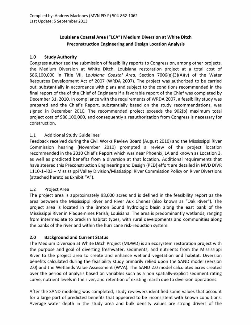
Location AAHU’s Marsh Habitat Ridge Habitat Total Net Acres*
Location 3 (Phoenix) 13,355 385 Acres 31 Acres 32,000
* Based on SAND2.0 model analysis (no estimate of cubic yards per year was calculated during feasibility)
Total First Cost
Federal Cost Non-Fed Cost Total
Monitoring Total Adaptive Management
Annual OMRR&R
$365,201,000 $237,831,000 $127,820,000 $8,807,000 $2,336,000 $1,468,000
8.0 Summary of PED Efforts Using knowledge gained since the original feasibility study was completed in 2010, the PDT focused PED activities only on locations that offered the greatest potential for suspended sediments to be diverted from the Mississippi River. Tasks undertaken during the PED phase include additional sediment sampling in the Mississippi River, FLOW-3D modeling at Location 3 initially and then at some other locations evaluated during the feasibility study, SAND modeling using an updated model version (v2.3 that better accounts for sediment grain sizes at a particular diversion location), bathymetric data collection in the Breton Sound basin to improve hydrodynamic modeling, Advanced Hydraulics (ADH) modeling for sediment and hydrodynamics, and finally preliminary cost estimates for conceptual design features were also calculated. Additional ADH modeling is currently tasked but the PDT is waiting for final results from the FLOW-3D structure optimization runs. These runs will allow the ADH model to more accurately reflect the ideal structure design which will better account for hydrodynamics in the Breton Sound basin as well as sediment transport in the outfall area. Evaluations to determine the effects a diversion could have on the Mississippi River using the 1D river model being developed under the LCA Hydrodynamic Study are also currently underway. Model runs have been developed for both for an individual diversion location as well as a cumulative effects assessment that incorporates other diversions identified in LCA and the State Master Plan. Results from that effort are expected to be completed in September 2013. The PDT has been coordinating efforts to ensure the best available information is being exchanged. 8.1 Mississippi River Sediment Sampling The PDT contracted with the U.S. Geological Survey (USGS) to perform sampling and analysis of suspended sediments in the Mississippi River for the project. Samples were collected between river miles 52.2 and 69.0 across eight transects. For each transect, five samples were collected at various depths of the water column (dependent upon location). This data was used to supplement the FLOW-3D and SANDv2.3 models and to provide an additional measurement of sediment grain sizes in the water column for the evaluated locations. 8.2 FLOW-3D Modeling The objective of this task is to perform riverine, intake structure and diversion channel analysis, and hydrodynamic modeling in support of the design phase of the project. The modeling effort focused on assessing various diversion alternatives to identify a design that best captures and delivers sediment toward the receiving basin while minimizing shoaling and head-cutting in the Mississippi River. To better assess all locations evaluated during the feasibility study, the river
model domain was extended upriver which improved the model’s ability to flow sediments through the area of interest. This resulted in improved evaluations of diversion structure location, design, and operation. The first task under this effort was to evaluate Location 3 with the features proposed during the feasibility study. This model run consisted of inputting a structure with ten 15’x15’ box culverts at an invert elevation of -16’ operating at up to full capacity (35,000 cfs) during the months of March and April only. Once model outputs were developed the PDT could assess the likelihood of being able to achieve the benefits predicted with the features evaluated during the feasibility study. It quickly became apparent that the feasibility study recommendation of Location 3 would not achieve the targets predicted with the SANDv2.0 model. From this point forward, the PDT made modifications to the structure (used in the model) that would enable the structure to better capture suspended sediments (especially coarser grains). These modifications included: (1) lowering the invert elevation to -40’; (2) moving the mouth of the intake channel slightly upstream, (3) changing the angle of the outfall channel; and (4) widening the forebay to allow river water to flow into and through the structure more readily. In all, four separate concepts were modeled at Location 3. The results clearly showed that all of the tested combinations of structure design, intake location, and alignment modifications at Location 3, fell far short of the feasibility study targets. During this task, a new diversion structure concept was created based on a tainter-gate design capable of flowing the full 35,000 cfs capacity through the diversion structure when the Mississippi River reaches 600,000 cfs. This new design concept was tested in the model using Location 3. The results showed that the new structure design achieved the highest sediment-to-water ratio of all previously tested structure and feature concepts. With the receipt of these positive results the PDT felt comfortable having the new structure design concept tested at other proposed diversion locations. Thereafter, the PDT focused on evaluating the tainter-gate structure at other locations considered during the feasibility study. However, instead of focusing on Location 2 the PDT (based upon professional judgment) decided that suspended sediment concentrations might be higher at a location about halfway between Locations 2 and 3 that would still offer the advantage of not having a back levee to contend with. This new location near the community of Carlisle became known as Location 2.5. Locations 1 and 4 were also developed conceptually and modeled. Each location was evaluated with features specific to the real-world conditions so that a proper representation in the model could be achieved and more accurate values could be generated to compare to those at Location 3. 8.3 SAND Modeling (Version 2.3) The SAND model is a spreadsheet model that is used to more efficiently assess diversion benefits over time given a set of input parameters. During the feasibility effort the PDT’s use of the SAND model raised questions since some of the input values were deemed inappropriate for the outfall area. Since that time the SAND model has gone through several minor revisions as well as a thorough critique of how input values affect and influence model outputs. In order to achieve the most realistic results under this PED effort numerous input values were reconsidered including average water depth of the study area, the Mississippi River sediment rating curve (which is based on locationally-accurate outputs from the FLOW-3D model),
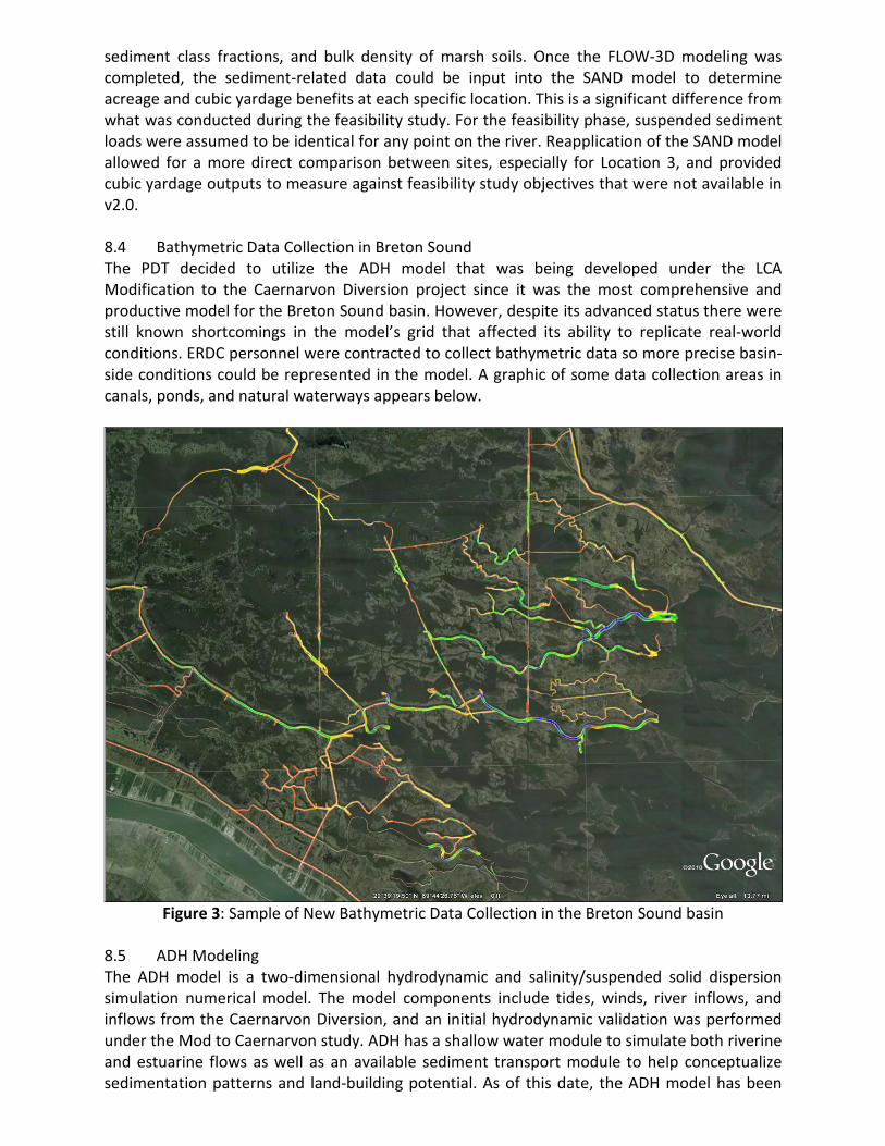
sediment class fractions, and bulk density of marsh soils. Once the FLOW-3D modeling was completed, the sediment-related data could be input into the SAND model to determine acreage and cubic yardage benefits at each specific location. This is a significant difference from what was conducted during the feasibility study. For the feasibility phase, suspended sediment loads were assumed to be identical for any point on the river. Reapplication of the SAND model allowed for a more direct comparison between sites, especially for Location 3, and provided cubic yardage outputs to measure against feasibility study objectives that were not available in v2.0. 8.4 Bathymetric Data Collection in Breton Sound The PDT decided to utilize the ADH model that was being developed under the LCA Modification to the Caernarvon Diversion project since it was the most comprehensive and productive model for the Breton Sound basin. However, despite its advanced status there were still known shortcomings in the model’s grid that affected its ability to replicate real-world conditions. ERDC personnel were contracted to collect bathymetric data so more precise basin-side conditions could be represented in the model. A graphic of some data collection areas in canals, ponds, and natural waterways appears below.
Figure 3: Sample of New Bathymetric Data Collection in the Breton Sound basin
8.5 ADH Modeling The ADH model is a two-dimensional hydrodynamic and salinity/suspended solid dispersion simulation numerical model. The model components include tides, winds, river inflows, and inflows from the Caernarvon Diversion, and an initial hydrodynamic validation was performed under the Mod to Caernarvon study. ADH has a shallow water module to simulate both riverine and estuarine flows as well as an available sediment transport module to help conceptualize sedimentation patterns and land-building potential. As of this date, the ADH model has been

used to predict tailwater conditions in the outfall channel as a support mechanism to the FLOW-3D model only. Additional work is scheduled for evaluation of Location 1 as the new recommended site in a stepwise fashion. Upcoming work includes analyzing sedimentation patterns for 10 proposed MDWD design scenarios; including up to four of the best performing sedimentation scenarios for further analysis of salinity impacts; and finally, evaluating two scenarios that document salinity effects for land building potential. Work on this task order is expected to be complete in November 2013. 9.0 Feature Development The PDT had features developed that informed the cost estimates and allowed the team to create sketches of what the diversion and channel would look like at each location. Features such as the highway bridge (channel overpass), levee tie-ins, and channel design were plotted on aerial photography and used to calculate additional design considerations such as feature footprints, habitat effects, and other landscape considerations. An overview of the four locations and the four initial design concepts are presented on the graphics below.
Figure 4: Overview of All Locations with Conceptual Channel Features
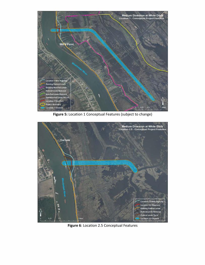
Figure 5: Location 1 Conceptual Features (subject to change)
Figure 6: Location 2.5 Conceptual Features
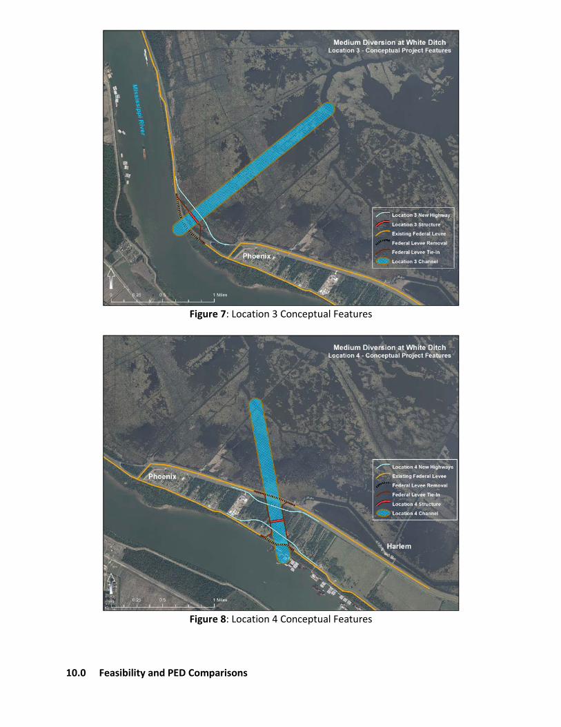
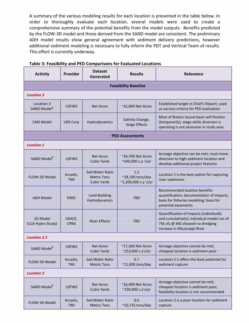
Figure 7: Location 3 Conceptual Features
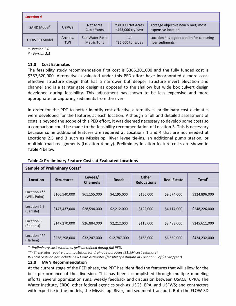
Figure 8: Location 4 Conceptual Features
10.0 Feasibility and PED Comparisons
A summary of the various modeling results for each location is presented in the table below. In order to thoroughly evaluate each location, several models were used to create a comprehensive summary of the potential benefits from the model outputs. Benefits predicted by the FLOW-3D model and those derived from the SAND model are consistent. The preliminary ADH model results show general agreement with sediment delivery predictions, however additional sediment modeling is necessary to fully inform the PDT and Vertical Team of results. This effort is currently underway. Table 3: Feasibility and PED Comparisons for Evaluated Locations
Activity Provider Dataset Generated Results Relevance
Feasibility Baseline
Location 3
Location 3 SAND Model* USFWS Net Acres ~32,000 Net Acres Established target in Chief’s Report; used
as success criteria for PED evaluation
CMS Model URS Corp Hydrodynamics Salinity Change, Stage Effects
Most of Breton Sound basin will freshen (temporarily); stage while diversion is operating is not excessive in study area
PED Assessments
Location 1
SAND Model# USFWS Net Acres Cubic Yards
~34,700 Net Acres ~540,000 c.y.’s/yr
Acreage objective can be met; must move diversion to high-sediment location and develop additional project features
FLOW-3D Model Arcadis, TWI
Sed:Water Ratio Metric Tons Cubic Yards
1.2 ~28,100 tons/day
~1,200,000 c.y.’s/yr
Location 1 is the best option for capturing river sediments
ADH Model ERDC Land-Building Hydrodynamics TBD
Recommended location benefits quantification; documentation of impacts; basis for fisheries modeling; basis for potential easements
1D Model (LCA Hydro Study)
USACE, CPRA River Effects TBD
Quantification of impacts (individually and cumulatively); individual model run of 75k cfs @ MG showed no dredging increase in Mississippi River
Location 2.5
SAND Model# USFWS Net Acres Cubic Yards
~17,300 Net Acres ~253,000 c.y’s/yr
Acreage objective cannot be met; cheapest location is sediment poor
FLOW-3D Model Arcadis, TWI
Sed:Water Ratio Metric Tons
0.7 ~11,600 tons/day
Location 2.5 offers the least potential for sediment capture
Location 3
SAND Model# USFWS Net Acres Cubic Yards
~16,400 Net Acres ~239,000 c.y’s/yr
Acreage objective cannot be met; cheapest location is sediment poor; feasibility location is not recommended
FLOW-3D Model Arcadis, TWI
Sed:Water Ratio Metric Tons
0.6 ~10,725 tons/day
Location 3 is a poor location for sediment capture
Location 4
SAND Model# USFWS Net Acres Cubic Yards
~30,000 Net Acres ~453,000 c.y.’s/yr
Acreage objective nearly met; most expensive location
FLOW-3D Model Arcadis, TWI
Sed:Water Ratio Metric Tons
1.1 ~25,600 tons/day
Location 4 is a good option for capturing river sediments
*- Version 2.0 # - Version 2.3 11.0 Cost Estimates The feasibility study recommendation first cost is $365,201,000 and the fully funded cost is $387,620,000. Alternatives evaluated under this PED effort have incorporated a more cost-effective structure design that has a narrower but deeper structure invert elevation and channel and is a tainter gate design as opposed to the shallow but wide box culvert design developed during feasibility. This adjustment has shown to be less expensive and more appropriate for capturing sediments from the river. In order for the PDT to better identify cost-effective alternatives, preliminary cost estimates were developed for the features at each location. Although a full and detailed assessment of costs is beyond the scope of this PED effort, it was deemed necessary to develop some costs so a comparison could be made to the feasibility recommendation of Location 3. This is necessary because some additional features are required at Locations 1 and 4 that are not needed at Locations 2.5 and 3 such as Mississippi River levee tie-ins, an additional pump station, or multiple road realignments (Location 4 only). Preliminary location feature costs are shown in Table 4 below. Table 4: Preliminary Feature Costs at Evaluated Locations
Sample of Preliminary Costs*
Location Structures Levees/ Channels Roads Other
Relocations Real Estate Total#
Location 1** (Wills Point) $166,540,000 $61,155,000 $4,195,000 $136,000 $9,374,000 $324,896,000
Location 2.5 (Carlisle) $147,437,000 $28,594,000 $2,212,000 $122,000 $4,114,000 $248,226,000
Location 3 (Phoenix) $147,270,000 $26,884,000 $2,212,000 $115,000 $3,493,000 $245,611,000
Location 4** (Harlem) $258,298,000 $32,247,000 $12,787,000 $168,000 $6,569,000 $424,232,000
*- Preliminary cost estimates (will be refined during full PED) **- These sites require a pump station for drainage purposes ($1.5M cost estimate) #- Total costs do not include new O&M estimates (feasibility estimate at Location 3 of $1.5M/year) 12.0 MVN Recommendation At the current stage of the PED phase, the PDT has identified the features that will allow for the best performance of the diversion. This has been accomplished through multiple modeling efforts, several optimization runs, weekly feedback and discussion between USACE, CPRA, The Water Institute, ERDC, other federal agencies such as USGS, EPA, and USFWS; and contractors with expertise in the models, the Mississippi River, and sediment transport. Both the FLOW-3D
and new SAND models account for suspended sediment concentrations in the Mississippi River at a particular location which is based on several sediment sampling efforts taken at different river flows and times-of-year. This feature demonstrates how important a location is for capturing sediments for delivery into the project area. As a result of the numerous modeling and optimization efforts, and the discussion and analyses undertaken during the PED assessment, USACE, the NFS, and the other participating agencies and entities are unanimous in the conclusion that Location 3 is highly unlikely to achieve the benefits predicted and formalized in the 2010 Chief’s Report. At the time of the feasibility study, the old SAND model was the best available tool to evaluate diversions especially given the LCA schedule constraints. Since the old SAND model used during the feasibility study generally assumed a uniform distribution of sediments throughout the water column at all river locations, it can now be seen how benefits might have been over-predicted. The New Orleans District recommends that the MDWD project be moved to Location 1 (Will’s Point) for several reasons:
- The restoration targets identified during the feasibility study cannot be achieved at Location 3;
- Suspended sediment concentrations are the highest at Location 1 which translates to increased benefits on the bayside;
- Location 1 is higher in the basin and study area which increases residence time for introduced sediments thereby increasing the likelihood for their settlement and capture;
- Preliminary cost estimates indicate the diversion structure, outfall channel, highway bridge, and all other features can be constructed for less money than the original feasibility study estimate (channel features will continue to be refined).
The NFS is in agreement with this recommendation and supports the PED conclusions and findings. Cooperating agencies also support this recommendation. 13.0 Additional Evaluations and Other Considerations In order to most efficiently coordinate modeling schedules and obtain results, the PDT has elected to proceed with additional tasks that focus on Location 1 due to the complexity, expense, and coordination required to initiate the 1D and ADH models. The PDT felt comfortable undertaking this risk given the significant disparity in potential benefits and costs that elevated Location 1 as the top performer. The PDT will continue to evaluate channel design concepts at Location 1. The range of costs for channel features varies widely and implementing the project at Location 1 with a shorter channel can reduce costs. Additional work with the ADH model can help inform the most efficient channel design for delivering sediments to the project area but this PED effort is still underway. The LCA Hydrodynamic study is currently evaluating with their 1D model both an independent White Ditch diversion as well as a cumulative effects run that incorporates this and other diversions from the LCA program and the CPRA Master Plan. Based on results for an independent 1D model run for Myrtle Grove at 75k cfs with a more frequent operational plan there is a slight decrease in maintenance dredging requirements through 2069 in the lower Mississippi River. The effects on river dredging needs due to White Ditch operations with a

smaller overall capacity and less frequent operational plan would be even less discernible. As an individual diversion, it appears there will be no effect upon current and predicted maintenance dredging activities in the Mississippi River. 1D model results for the individual and cumulative effects runs will be available in September 2013. There has not been a determination as to the number of acres over which flowage easements will be required or whether any non-standard estates will be required across the outfall area. At this time, there are insufficient known facts to be able to undertake such an analysis and make such a determination. Although a final decision on this issue has not been formalized by MVN, the ADH model will help inform the discussion because of its ability to provide information on the timing, duration, and frequency of stage increases from waters leaving the outfall channel. Once this information is provided and a formal position from MVN is developed an update can be provided to the Vertical Team.