Loudoun County African-American Historic Architectural ...
140
Loudoun County African-American Historic Architectural Resources Survey Lincoln "Colored" School, 1938. From the Library of Virginia: School Building Services Photograph Collection. Prepared by: History Matters, LLC Washington, DC September 2004 Sponsored by the Loudoun County Board of Supervisors & The Black History Committee of the Friends of the Thomas Balch Library Leesburg, VA
Transcript of Loudoun County African-American Historic Architectural ...

Loudoun County
African-American Historic Architectural Resources Survey
Lincoln "Colored" School, 1938. From the Library of Virginia: School Building Services Photograph Collection.
Prepared by:
History Matters, LLC
Washington, DC
September 2004
Sponsored by the Loudoun County Board of Supervisors
&
The Black History Committee of the Friends of the Thomas Balch Library
Leesburg, VA
Loudoun County
African-American Historic Architectural Resources Survey
Prepared by:
Kathryn Gettings Smith
Edna Johnston
Megan Glynn
History Matters, LLC
Washington, DC
September 2004
Sponsored by the Loudoun County Board of Supervisors
&
The Black History Committee of the Friends of the Thomas Balch Library
Leesburg, VA
Loudoun County Department of Planning
1 Harrison Street, S.E., 3rd Floor
Leesburg, VA 20175
703-777-0246

1
Table of Contents
I. Abstract 4
II. Acknowledgements 5
III. List of Figures 6
IV. Project Description and Research Design 8
V. Historic Context
A. Historic Overview 10
B. Discussion of Surveyed Resources 19
VI. Survey Findings 56
VII. Recommendations 58
VIII. Bibliography 62
IX. Appendices
A. Indices of Surveyed Resources 72
B. Brief Histories of Surveyed Towns, Villages, Hamlets,
& Neighborhoods
108
C. African-American Cemeteries in Loudoun County 126
D. Explanations of Historic Themes 127
E. Possible Sites For Future Survey 130
F. Previously Documented Resources with Significance to
Loudoun County’s African-American History
136

2
Figure 1: Map of Loudoun County, Virginia with principal roads, towns, and waterways. Map courtesy of the
Loudoun County Office of Mapping.

3
Figure 2. Historically African-American Communities of Loudoun County, Virginia. Prepared by Loudoun County
Office of Mapping, May 15, 2001 (Map #2001-015) from data collected by the Black History Committee of the
Friends of Thomas Balch Library, Leesburg, Va.

4
I. Abstract
History Matters surveyed 210 properties that relate to the history of African Americans in Loudoun
County, Virginia. Of the surveyed properties, 200 were surveyed at the reconnaissance level
(exterior documentation) and ten were intensively documented (exterior and interior). The
documented resources date from the late 18th
through the mid-20th
centuries.
Approximately 90 percent of the surveyed properties are located within the 30 historically African-
American towns, villages, hamlets or neighborhoods that the project’s cosponsor, the Black History
Committee of the Friends of the Thomas Balch Library, identified during their African American
Community mapping project in 2001. Initial research suggests that most of the identified
communities were founded by African Americans in the three decades that followed the end of the
American Civil War. Many of the villages were established by former slaves who purchased land
from white landowners.
Documented building types include single- and multi-family dwellings, schools, commercial
buildings, religious buildings, and cemeteries. By far, the most common building type was the
single-family dwelling. While stylistic trends were generally muted, some common forms and
building techniques were discernable. Loudoun’s African-American communities were characterized
by clusters of modest residences that were often accompanied by churches or schools and, less
frequently, by general stores.
Three types of African-American communities were documented: independent communities
(Willisville, St. Louis, Bowmantown, Hillsboro/Short Hill); segregated neighborhoods or enclaves
within larger, mixed-race towns (Purcellville, Hamilton, and Round Hill); and small, mixed-race
rural communities (Sycolin and Watson).

5
II. Acknowledgements
History Matters thanks the following individuals & organizations for their kind assistance:
Meredyth Breed, Claude Moore Park
Josephine Brown
Alice H. Calhoun
James M. and Elizabeth Campanella
Charles P. Clark
Harrison Cook, Virginia Department of Historic Resources
Phyllis Cook-Taylor
Peter Daley
Dean T. and Paula Drewyer
Fred Drummond
David Edwards, Virginia Department of Historic Resources
Peggy Fallon
Pastor Robert Grayson
Marty Hiatt
Arlean Hill
Quatro Hubbard, Virginia Department of Historic Resources
Eric Larson, Loudoun Heritage Farm Museum
Deborah A. Lee
Tina L. Leight
Phil Lo Presti, Jr.
Staff of Loudoun County Office of Mapping & Geographic Information
Staff of Loudoun County Department of Planning
La Vonne Markham
Maura McKenney
Kathryn Miller
Betty Morefield
Lorraine Moten
Mount Pleasant Baptist Church, Bowmantown, VA
Elizabeth Nokes
Denise Oliver Velez
Trent Park, Virginia Department of Historic Resources
Tom Pratt
Mary E. Randolph
Paul E. Rose, Waterford Union Cemetery Trustees
Wynne C. Saffer
Pauline Singletary
Bronwen Souders
Belinda Thomas
Staff of Thomas Balch Library, Leesburg
Elaine E. Thompson
Waterford Foundation, Inc.
Mark Wagner, Virginia Department of Historic Resources
Lou Etta Watkins
Susan Webber
Francine Williams

6
III. List of Figures
Figure Page
1 Map of Loudoun County, Virginia with principal roads, towns, and waterways. 4
2 Historically African-American Communities of Loudoun County, Virginia. 5
3 John Henry’s 1770 Map of Virginia. 12
4 Portion of Bishop James Madison’s 1807 map of Virginia. 14
5 Preliminary map of northern Virginia. Circa 1860. 16
6 Emancipation Day Notice, 1933. 18
7 Douglas High School, Leesburg. 19
8 House, 46531 Harry Byrd Highway, Nokesville. (DHR #053-5224). 21
9 Napper Log House, Stewartown. (DHR #053-1024). 22
10 Joseph and Sarah Brown House, Brown’s Corner. (DHR #503-35-4209). 23
11 Walsh Farm Slave Quarter, Paxson/Berkley. (DHR #053-5139). 25
12 Gracie Reid House, Howardsville. (DHR #053-0062-0005). 27
13 Store, 35285 Snake Hill Road, St. Louis. (DHR #053-5099-0009). 29
14 House, 23965 Bowmantown Road, Bowmantown. (DHR #053-0605-0004). 30
15 Brown Family House, Macsville. (DHR #053-5151). 31
16 House, 20058 Sycolin Road, Sycolin. (DHR #053-5215). 32
17 Jim Henderson House, Round Hill. (DHR #291-5001). 33
18 House, 330 G Street, Purcellville. (DHR #286-5001-0231). 34
19 House, 24060 New Mountain Road, Bowmantown. (DHR #053-0605-0007). 35
20 House, 34090 Snickersville Turnpike, Murphy’s Corner. (DHR #053-5141-0003). 36
21 House, 23381 Sam Fred Road, Macsville. (DHR #053-5150). 37
22 Lincoln ―Colored‖ School, Lincoln. (DHR #053-0845). 38
23 Hillsboro ―Colored‖ School (former), Short Hill. (DHR #053-5206). 39
24 Mount Pleasant Baptist Church, Lucketts vicinity. (DHR #053-0322). 41
25 Mount Pleasant Baptist Church, Bowmantown. (DHR #053-8316). 42
26 Grace Methodist Episcopal Church, Lincoln. (DHR #053-0205). 43
27 Asbury Methodist Episcopal Church, Hillsboro vicinity. (DHR #053-0909). 44
28 Nokes House, Nokesville. Façade or south elevation (DHR #053-5223). 46
29 Fisher House and Workshop, Macsville. (DHR #053-5152). 47
30 House, 33960 Welbourne Road, Willisville. (DHR #053-5116-0013). 48
31 House, 33978 Welbourne Road, Willisville. (DHR #053-5116-0011). 49
32 Irene H. Trammell House, St. Louis. (DHR #053-5099-0002). 50

7
Figure Page
33 Willing Workers Hall/Purcellville ―Colored‖ School, Purcellville. (DHR #286-5003). 51
34 Middleburg Baseball Team ―Bush League‖ at Hall’s Park. (DHR #053-5155) 51
35 Willisville Chapel, Willisville. (DHR #053-1043). 52
36 House, 34007 Welbourne Road, Willisville. (DHR #053-5116-0007). 53
37 Banneker School, St. Louis. (DHR #053-0605-0004). 54
38 Grace Annex Methodist Episcopal Church, Purcellville. (DHR #286-5001-0230). 55

8
IV. Project Description and Research Design
In 2002 and 2003, under contract to the Loudoun County Board of Supervisors, History Matters
surveyed 210 historic resources that relate to the history of African Americans in Loudoun County,
Virginia. Of the surveyed properties, 200 were surveyed at the reconnaissance level (exterior
documentation) and ten were intensively documented (exterior and interior). The documented
resources date from the late 18th
through the mid-20th
centuries.
History Matters’ research team was comprised of the following individuals: William Critzman, Patsy
Fletcher, Megan Glynn, Kendra Hamilton, Edna Johnston, Jean McRae, and Kathryn Gettings
Smith. Edna Johnston is the Principal of History Matters and directed the project with Kathryn
Gettings Smith, History Matters’ Senior Architectural Historian. Ms. Smith led the team’s survey
and research efforts.
Throughout the project, History Matters worked closely with the Loudoun County Department of
Planning and with the Virginia Department of Historic Resources (DHR).
Before physical survey began, History Matters reviewed existing research materials and survey data
at DHR headquarters in Richmond, Virginia and at Loudoun County. We also collected relevant
research materials from libraries in Loudoun County and Washington, DC and consulted resources at
the Library of Virginia and the Virginia Historical Society in Richmond, Virginia, and at Alderman
Library at the University of Virginia in Charlottesville. Primary sources consulted included historic
maps, census information, Loudoun County property records, and antebellum registration records of
Loudoun County’s free persons of color. In addition, History Matters utilized relevant information
from surveys that had been conducted in the 1970s and 1980s by DHR and by its predecessor, the
Virginia Historic Landmarks Commission.
At the instruction of the Department of Planning, History Matters first surveyed those sites that the
County identified as most threatened. In addition, History Matters responded to several urgent
requests by Loudoun County staff to survey sites that were deemed to be in immediate danger of
destruction.
After conducting a windshield survey of the County with David Edwards, the director of DHR’s
Winchester office, to identify potential sites, it was determined that many more sites than those that
were initially identified would be needed to meet the project goal of surveying 200 sites. Using data
generated by the Black History Committee of the Friends of the Thomas Balch Library’s
Community Mapping Project that identified approximately 30 African-American communities in
Loudoun County, History Matters asked local informants to help it define the boundaries of these
communities and to identify historic sites to be surveyed (fig. 2).
Charles Clark, Pastor Robert Grayson, Arlean Hill, Deborah Lee, Maura McKenney, Lorraine
Moten, Mary Randolph, Elaine Thompson, and Francine Williams spent long hours working with
Kathryn Gettings Smith and Patsy Fletcher of History Matters to identify nearly one hundred
additional historic resources. They and other members of the Black History Committee also
contacted or helped History Matters contact local residents to identify sites, conduct interviews, and
facilitate site visits. Black History Committee Chair Pauline Singletary and Phyllis Cook Taylor
provided contacts and publicity along with moral support for the additional work that was required.

9
Throughout the entire project period, the Richmond DHR staff spent countless hours helping History
Matters to obtain and analyze relevant information contained in two DHR databases, the obsolete
Integrated Preservation Software (IPS) and the new Data Sharing System (DSS). Navigating
between the two state systems and then importing the data to more readily available data base
software proved to be technically very difficult but crucial to the project’s overall success. History
Matters is deeply grateful to all those who assisted us.

10
V. Historic Context
A. Historic Overview
Figure 3. John Henry’s 1770 Map of Virginia. From The Cartography of Northern
Virginia: Facsimile Reproductions of Maps Dating From 1608 to 1915 by Richard W.
Stephenson. History and Archaeology Section, Office of Comprehensive Planning:
Fairfax County, VA, 1981. Plate 15.
Loudoun County, 1722-1800
Located in the foothills of the Blue Ridge Mountains, Loudoun County was a part of the Virginia
colony’s western frontier during the early 18th
century. In 1722, Alexander Spotswood, Virginia’s
royal governor between 1710 and 1722, negotiated the Treaty of Albany with the Iroquois Nation,
who ceded all of the territory east of the Blue Ridge to the colony of Virginia. This helped to entice
to the west immigrants from Europe and migrants from other English colonies who sought
inexpensive, fertile land, a commodity which was becoming increasingly difficult to find in the more
settled portions of nearby colonies such as Pennsylvania and Maryland. In addition, land speculation
and soil exhaustion in much of eastern Virginia spurred migration from the more settled Tidewater
region.1 Generally, the Tidewater migrants settled in the southeastern portion of Loudoun and
1 Emily J. Salmon and Edward D.C. Campbell, Jr., editors, The Hornbook of Virginia History, (Richmond, VA: The
Library of Virginia, Fourth Edition, 1994), p. 25.

11
established large tobacco-producing plantations, similar to those that they had left in the Tidewater
region. They brought the institution of slavery with them.
By 1749, approximately 2,200 people, representing a variety of ethnic groups, including descendents
of English, German, and Scotch-Irish settlers and more than 600 African-born and Creole slaves
(those born in Great Britain’s colonies, including Virginia), populated the area that would become
Loudoun County.2 The majority of those enslaved were young men from western Africa. In 1757,
in response to the growth of settlement in this area, the Virginia General Assembly formed Loudoun
County out of northwestern Fairfax County.
The American victory in the Revolutionary War (1775-1781) had a profound effect on Loudoun
County’s government, economy, society, and culture. In the 1783 Treaty of Paris that formally
ended the American Revolution, Great Britain ceded the land west of the Appalachian Mountains to
the newly formed United States. Although Native Americans continued to challenge the new
country’s claims to the western lands, thousands of Americans traveled across the mountains in
search of cheap land and better economic opportunities. By 1790, the year of the first United States
census, Loudoun County’s total population had grown to just under 19,000 people of whom 4,213
were people of color, the vast majority of whom were slaves.
The most significant event for African and Creole slaves in Loudoun and throughout the former
American Colonies was the ratification of the United States Constitution in 1787. Under the new
constitution, Congress was given authority to end the importation of slaves after 20 years, but no
sooner. This Congress did on January 1, 1808. With the end of importation, the slave population in
Loudoun became more Creole, thus more African American than African.3
In addition, the Constitution institutionalized the ―three-fifths‖ clause under which representatives in
the U.S. House of Representatives were apportioned among the states based on total population.
Population was determined by counting all free persons and three-fifths of the slaves. In this
manner, states like Virginia, with small free populations, were able to counter domination by states
with large free populations and relatively few slaves. In addition to determining representation in
the House and the Electoral College, the Constitution prevented Congress from imposing a head tax
on slaves and thus gave one more tremendous benefit to slave owners at the expense of non-slave
owners.
By 1800, Loudoun’s population totaled 20,523. Three-hundred and thirty-three residents were free
people of color; 4,990 Loudoun residents were enslaved, thus just over twenty-five percent of
Loudoun’s population was African or of African descent. Loudoun’s African-American population
would have been even greater if, in 1798, Fairfax County had not re-acquired the southeastern
portion of Loudoun. Historians of the region estimate that Loudoun lost 4,034 of its total
population. Of this group, 1,658 were slaves.4 Despite losing both land and population to Fairfax,
the expansion of western settlements in the late 18th
and early 19th
centuries spurred Loudoun’s
growth, though it slowed during the 1830s and 1840s. By 1860, Loudoun’s population hovered
under 22,000; 1,200 were free people of color and 5,501 were enslaved African Americans.
2 Brenda E. Stevenson, Life in Black and White, Family and Community in the Slave South [New York: Oxford
University Press, 1996] 352, fn 60. 3 After 1808 the internal trading in slaves continued in those states where slavery was legal, namely all states but
Pennsylvania, Massachusetts, New Hampshire, Connecticut, Rhode Island, New York, and New Jersey. 4 See Nan Netherton et al., Fairfax County, Virginia: A History [Fairfax, VA: Fairfax County Board of Supervisors,
1978] pp 29-36.

12
Life Enslaved, Life Free: African Americans in the Early National and
Antebellum Period (1800-1860)
Figure 4. Portion of Bishop James Madison’s 1807 map of Virginia showing Loudoun County. From The
Cartography of Northern Virginia: Facsimile Reproductions of Maps Dating From 1608 to 1915 by Richard W.
Stephenson. History and Archaeology Section, Office of Comprehensive Planning: Fairfax, Virginia, 1981. Plate 22.
Life Enslaved…
Slavery was an integral and visible part of Loudoun County’s social, economic, and political life;
indeed it was the cornerstone of southern society of which Loudoun was part. What was life like for
those Loudoun residents who were enslaved? How did free people of color live in a slave-based
society? In Loudoun County, the answers to these questions depended on where one lived and
during what period of time.
A significant influence on Loudoun’s population throughout this period was the forced migration of
people due to Loudoun’s domestic slave trade. According to historian Brenda Stevenson, more than
1,000 Loudoun slaves were sold between 1800 and 1810. Between 1850 and 1860 approximately
1,300 slaves were sold out of the county.5 As a slave in Loudoun County, one lived under the
constant reality that you and members of your family would be sold at least once in your lifetime.
The majority of slaves in Loudoun County lived on plantations that were owned by owners who
owned large numbers of African Americans. Stevenson has determined that, ―46 percent of
Loudoun slaves were part of holdings of 10 or more slaves in 1820; 45 percent in 1850.‖6 Ninety
percent of Loudoun County slaves were field workers who cleared land, cultivated and harvested
5 Stevenson, p. 176.
6 Stevenson, p. 177.

13
crops, and performed all the labor needed to establish and maintain the lands possessed by their
owners.
Throughout the antebellum period, slaves who lived in the town of Leesburg, the county seat of
Loudoun County, worked as household servants, as tavern workers, and as skilled artisans. Over the
course of their lives, they often worked in several households, as Leesburg slave owners frequently
hired out or rented slaves to non-slaveholding whites in the town or in the surrounding rural areas.
Slave life in Leesburg differed from rural slave life in many ways. Leesburg slaves, particularly
those who were skilled artisans, found more opportunities to make money than did slaves on
plantations. Compared to the majority of slaves in Loudoun County, slaves in Leesburg probably
had more contact with each other and with the small number of free blacks in Leesburg than did
rural slaves. Since most Leesburg slaves worked in households or in small shops, they tended to
have closer contact with their owners. However, this more intimate contact also curtailed any
private time that Leesburg slaves had, making it difficult for them to elude physically and sexually
abusive owners.
Life Free…
If one were a free person of color in Loudoun during the antebellum period, one could look to
communities of support among other free people, especially in the Loudoun towns of Leesburg,
Middleburg, Hamilton, Snickersville (now Bluemont), Waterford, Lovettsville, and Hillsboro.
However, whatever support there was among free blacks for each other was dwarfed by the hostility
of Loudoun slaveholders and state law. In 1831, explicit displays of hostility became heightened
after Nat Turner, a slave in Southampton County, Virginia, began a slave revolt in which 57 whites
were killed. The rebellion ultimately failed and local whites executed Turner and killed 200 slaves
in retaliation. Starting in 1831, Virginia began to pass a series of laws specifically aimed at
restricting the rights of free blacks. These included barring African Americans from owning
weapons (a particularly difficult burden in rural societies), restricting their businesses and their
freedom of movement, and most ominously for Loudoun’s free blacks, outlawing them and their
children from learning to read or attending school.7
7 For an in depth account of the experiences of free blacks in Loudoun, see Stevenson, pp 258-319.

14
The Civil War and the End of Slavery (1861-1865)
Figure 5. Preliminary map of northern Virginia embracing portions of Loudoun, Fauquier, Prince William, and
Culpeper Counties. ca. 1860. Available at HTTP://hdl.loc.gov/loc.gmd/g38831.cwh00011
In November 1860, Republican Abraham Lincoln was elected president of the United States and the
Republican Party won the congressional elections, enabling the relatively new political party to take
control of both houses of Congress for the first time. In response, several states in the lower south
that felt threatened by the Republican Party’s support of anti-slavery initiatives, held a series of state
conventions to consider seceding from the Union. On April 12, 1861, in Charleston, South Carolina,
troops fired at the Union garrison of Fort Sumter. On April 17, 1861, following the attack and
President Abraham Lincoln’s subsequent order for federal troops to occupy northern Virginia, the
Virginia Secession Convention voted to secede from the Union. Loudoun’s two delegates to the
convention, John Janney and John A. Carter, voted against secession. However, when the public
was asked to ratify the ordinance of secession in May of 1861, the majority of Loudoun County’s
eligible voters supported secession.8 The American Civil War (1861-1864) would not end for four
years. During the war 620,000 soldiers and sailors and an unknown number of southern civilians
would lose their lives.
Throughout the war, Loudoun County was successively occupied by both armies. As a border area,
the county witnessed significant troop movements through its boundaries, one major battle, and
numerous minor skirmishes. Raids on Union forces by Confederate partisan groups, including the
band led by John Singleton Mosby, were common. Both armies destroyed or confiscated residents’
8 Three of Loudoun’s 15 precincts voted against secession: Lovettsville, Waterford and Waters. Charles Preston Poland,
Jr. From Frontier To Suburbia (Marceline, MO: Walsworth Publishing Company, 1976), p.180.

15
foodstuffs, livestock and personal property in order to support their troops or to insure that the
supplies did not benefit enemy forces.9
In 1863, Lincoln issued the Emancipation Proclamation that declared all slaves in Confederate
territory to be free. As Union troops advanced into southern territory, they freed thousands of
slaves. In January 1865 Congress passed the 13th
Amendment that banned slavery throughout the
United States.
Many African Americans held their own referendum on slavery during the Civil War and
immediately afterwards by leaving Loudoun County when they were able to do so. In the U.S.
Census of 1860, 6,753 African Americans lived in Loudoun, the vast majority of who were enslaved.
By 1870, census figures show the total population of African Americans to be 5,691.
Freedom, Violence, and Segregation, 1866 to 1902
Little more than a week after the war’s end in April 1865, Lincoln was assassinated and succeeded
by Vice President Andrew Johnson, a Democrat from Tennessee. Tensions between Johnson and the
Republican-led Congress about how to treat the defeated South and the newly freed slaves led to
Johnson’s impeachment in the House of Representatives and his near removal from office by the
Senate. Without Johnson’s support, the Congress began the programs that would become known as
the era of Reconstruction (1866-1877).
During Reconstruction, federal troops were stationed in Virginia and throughout the South to enforce
the peace and to enfranchise African-Americans. In 1866, the 14th Amendment to the Constitution
was passed guaranteeing due process and equal protection under the law to all American citizens and
granting citizenship to African Americans. In 1869, the 15th Amendment was ratified, giving
African-American men, but not women, the right to vote. That same year, Virginia became the only
state in the former Confederacy to pass a constitution that granted black men the right to vote.
African-American men would continue to participate in politics and be elected to political positions
through the late 1880s until, in the early 1890s, when electoral fraud and physical violence on the
part of many whites drove African Americans from electoral politics.
As the end of the 19th
century approached, the promise of equal rights for all American men over the
age of twenty-one was increasingly abandoned as a new, race-mediated system of political,
economic, and social relationships – racial segregation – appeared. By the early 20th century, this
legally sanctioned, white–dominated political and economic system was in place throughout Virginia
and the South. Under it, African Americans (who made up about ten percent of the population of
Loudoun County) lost access to their right to vote. Legally, they could and most often were paid less
than whites even if performing the same work and the only public schools available to them were
funded at a lower level than whites.
Jim Crow Thrives…and Is Contested
The Virginia Constitution of 1902 disenfranchised most Virginians by limiting the right to vote to
war veterans, their adult sons, and to property owners who paid at least $1 in property taxes, or who
9 For a thorough discussion of Loudoun County’s position during the Civil War see Poland, pp. 183-220.
16
could give a ―reasonable explanation‖ of any part of the new constitution. In addition, potential
voters were required to complete registration applications in their own handwriting, and to answer
―any and all questions‖ asked by local registrars ―concerning his qualifications as an elector.‖ It also
imposed a poll or voting tax on all residents who wished to register to vote. Thus, poor men (women
were not allowed to vote in Virginia or U. S. elections until the passage of the 19th
amendment in
1920) who were unable to pay the poll tax, men who could not read or write, and men that local
registrars ruled did not answer questions ―correctly‖ about the 1902 constitution were barred from
voting. This ―reduced the number of Virginia’s voters by more than half and cut the number of
black voters from about one hundred and forty-seven thousand to fewer than ten thousand by
1904.‖10
In Loudoun County, the number of voters for the presidential election of 1900 was reduced
by half by the time of the 1904 presidential election.11
The size and status of Virginia’s electorate
would not change until the federal Voting Rights Act of 1965 and the 1966 U.S. Supreme Court
decision that outlawed Virginia’s imposition of the poll tax.
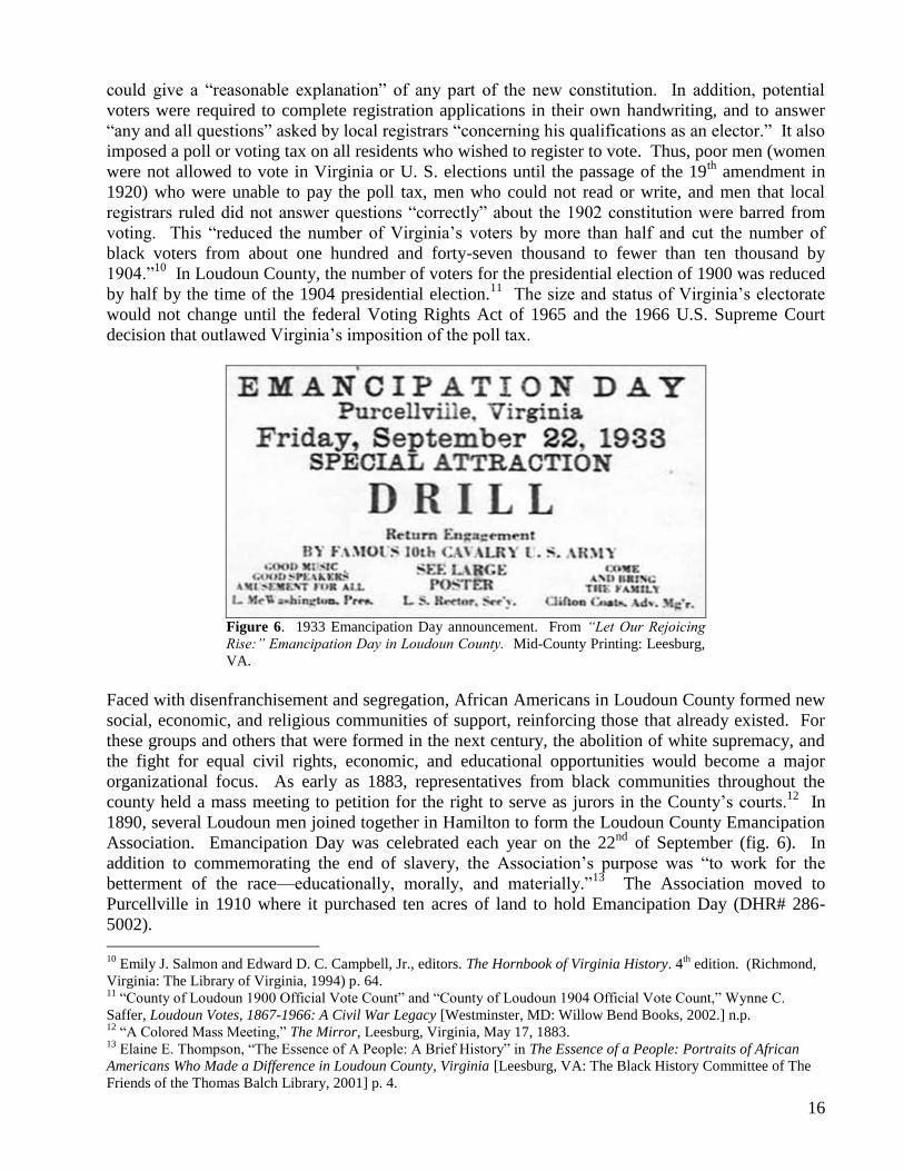
Figure 6. 1933 Emancipation Day announcement. From “Let Our Rejoicing
Rise:” Emancipation Day in Loudoun County. Mid-County Printing: Leesburg,
VA.
Faced with disenfranchisement and segregation, African Americans in Loudoun County formed new
social, economic, and religious communities of support, reinforcing those that already existed. For
these groups and others that were formed in the next century, the abolition of white supremacy, and
the fight for equal civil rights, economic, and educational opportunities would become a major
organizational focus. As early as 1883, representatives from black communities throughout the
county held a mass meeting to petition for the right to serve as jurors in the County’s courts.12
In
1890, several Loudoun men joined together in Hamilton to form the Loudoun County Emancipation
Association. Emancipation Day was celebrated each year on the 22nd
of September (fig. 6). In
addition to commemorating the end of slavery, the Association’s purpose was ―to work for the
betterment of the race—educationally, morally, and materially.‖13
The Association moved to
Purcellville in 1910 where it purchased ten acres of land to hold Emancipation Day (DHR# 286-
5002).
10
Emily J. Salmon and Edward D. C. Campbell, Jr., editors. The Hornbook of Virginia History. 4th
edition. (Richmond,
Virginia: The Library of Virginia, 1994) p. 64. 11
―County of Loudoun 1900 Official Vote Count‖ and ―County of Loudoun 1904 Official Vote Count,‖ Wynne C.
Saffer, Loudoun Votes, 1867-1966: A Civil War Legacy [Westminster, MD: Willow Bend Books, 2002.] n.p. 12
―A Colored Mass Meeting,‖ The Mirror, Leesburg, Virginia, May 17, 1883. 13
Elaine E. Thompson, ―The Essence of A People: A Brief History‖ in The Essence of a People: Portraits of African
Americans Who Made a Difference in Loudoun County, Virginia [Leesburg, VA: The Black History Committee of The
Friends of the Thomas Balch Library, 2001] p. 4.

17
Other voluntary organizations in Loudoun formed during this period to support one another and the
community in the face of official intransigence to demands for equal rights and educational
opportunities. In particular, churches, mutual benefit societies and organizations such as the Odd
Fellows, the Willing Workers Club, and the Society of Galilean Fisherman focused on providing
superior schools and education for African Americans when Loudoun County’s government failed to
do so.
In the late 1930s, African Americans in Loudoun formed the County-Wide League, an umbrella
organization of county parent-teacher associations that worked for and pressured the local
government to provide adequate bus transportation for students and for an accredited high school
that African Americans from Loudoun could attend. In 1941, their efforts and the efforts of the
newly formed Loudoun chapter of the National Association for the Advancement of Colored People
(NAACP) led to the opening of Frederick Douglass High School in Leesburg (fig. 7, DHR #253-
0070).
Figure 7. Douglass High School, Leesburg. Class of 1947. From Virginia
Landmarks of Black History: Sites on the Virginia Landmarks Register and the
National Register of Historic Places prepared and edited by Calder Loth,
University Press of Virginia: Charlottesville, VA, 1995. p.56 (DHR #253-0070).
When World War II ended, Loudoun’s population began to rise. Though it was most notable in the
eastern part of the County, all of Loudoun’s towns began to witness a new demographic patterns as
residents from nearby cities like Washington, DC began to make their homes in Loudoun even as
they commuted to their jobs in the region’s larger urban areas. Improvements to local roads and the
ever-increasing use and affordability of automobiles caused a fundamental shift in the way
Loudouners and all Americans lived and worked.14
14
By 1960, 28 percent of the county’s residents commuted to jobs outside the county. By 1970, that figure had increased
to 40 percent. Poland, p. 342.

18
In addition to great demographic changes, the period after World War II witnessed profound social
changes, especially in regards to civil rights for African Americans. In May 1954, the U.S. Supreme
Court in Brown v. Board of Education of Topeka, Kansas overturned the 1896 Plessy vs. Ferguson
Supreme Court decision that declared ―separate but equal‖ – a legal status under which segregation
by race had been deemed constitutional. The 1954 Supreme Court reversed the 1896 decision,
declaring that separate facilities for blacks and white were inherently unequal. In Virginia, as in the
rest of the southern United States, this meant that legal racial segregation; one means by which the
state had enforced white supremacy was now unconstitutional. In response to the 1954 decision,
white Virginia politicians, led by U.S. Senator Harry Byrd, announced that they would defy the
Supreme Court decision by all legal means possible. Between 1955 and 1958, the Virginia General
Assembly, passed a series of laws designed to prevent integration. What Byrd termed ―massive
resistance‖ to the integration of public schools in Virginia, had begun.
African-American students and their parents faced continual resistance from county and state
authorities to their efforts to fully integrate Loudoun County’s public schools. Full integration
would not take place until 1968 when, on behalf of the people of Loudoun County, the United States
Justice Department brought a successful lawsuit against the county to force it to integrate at the
student, teacher, and administrative levels.
Coinciding with this fundamental change in Loudoun County’s social and legal framework has been
the accelerating rate of Loudoun’s total population growth. From a total population of just under
25,000 in 1960, Loudoun County has become the fastest growing county in the United States with a
population today of more than 220,000. Such phenomenal growth has lent added urgency to efforts
to document the physical evidence of 280 years of the African-American experience in Loudoun
County.

19
V. HISTORIC CONTEXT
B. DISCUSSION OF SURVEYED RESOURCES
The discussion below outlines the individual resources and their thematic groupings within a
series of time periods of Virginia History that DHR has defined in their Guidelines For
Conducting Cultural Resource Survey in Virginia (1999, Revised 2003). Each section endeavors
to describe the common and distinctive characteristics of the built resources that were surveyed
within each historical period and category and gives representative examples from the 210
Loudoun resources that were documented.
Colony to Nation (1750-1789)
One resource from the Colony to Nation period was identified during the survey. According to
local tax records the 2-½ story, side-gable, log house that stands at 46531 Harry Byrd Highway
(Route 7) was built circa 1770 (DHR #053-5224). This house displays typical features of late
18th and early 19th century log construction, including wide areas of chinking between the
squared-off logs and V-notched corner connections (fig. 8).
Figure 8. House, 46531 Harry Byrd Highway, Nokesville. North corner
(DHR #053-5224).
Local sources speculate that this early log house was built by Quakers and was owned by free
blacks before the Civil War. Reputedly, it served as a safe house on the Underground Railroad.
No definitive research has confirmed these theories, however, the house stands near the Potomac
River and a historic ferry crossing. The house is located in an area that, by the late 1800s, was
known locally as Nokes or Nokesville. Named after a former slave who farmed land in the area,
Nokesville developed into a small African-American community during the early 20th
century
(see Appendix B).

20
Early National Period (1790-1830)
Domestic
Eight Early National Period domestic properties were identified during the survey. Most of
these dwellings were originally built for whites and later owned or occupied by African
Americans. A good example is the Raymond and Mattie Berryman House (DHR #053-0932)
near Mountville. The earliest part of this house may have been constructed as early as circa
1790. By the second quarter of the 19th century, the property was part of the estate of James B.
Wilson. Circa 1877, the original 1.5-story house was greatly expanded with the addition of the
front, 2-story center-passage, single-pile plan stone house. In 1922, Thomas J. and Raymond F.
Berryman purchased the 130-acre property, including the house. According to local informants,
theirs was the largest land holding held by African Americans in Loudoun County at that time.
Raymond and Mattie Berryman lived in the house and owned it until 1958. Mattie Berryman
worked as a teacher at the nearby Marble Quarry School.15
The house is a good example of a
stylish, vernacular stone house of the late 19th century.
The circa-1800 James E. Smith House (DHR #053-0587) reflects a common early-19th century
house type in Loudoun County. Its stone walls, massive interior-end chimney, and simple two-
story, side-gable, I-house form were common in Loudoun’s domestic architecture of the late 18th
and early 19th century. The property includes a historic outbuilding whose original use is not
known, but it now appears to be used as a workshop or guesthouse.
The property is located in a historically African-American hamlet known as Macsville.
According to local tradition, Macsville was named after the McVeigh family that settled in
Loudoun County in 1793. The name apparently referred to the group of slave quarters,
outbuildings, and warehouses owned by the McVeighs that stood along the former Ashby’s Gap
Turnpike, now Route 50 (John Mosby Highway).16
African-Americans continue to live in the
small hamlet.
One house that was documented at the intensive level may have been occupied by a freed slave
prior to the Civil War. The Frank Napper log house (DHR #053-1024) in Bowmantown is an
unusual example of a dog-trot log structure, perhaps the only remaining example in Loudoun
County (fig. 9). Although little is known about its origins, its form, materials, and construction
suggest that it was built in the first or second quarter of the 19th century. The house was home
to the Napper family who were among the earliest African-American settlers in the hamlet that
became known as Bowmantown (see Appendix B).
15 Notes taken by Deborah Lee, student in Eugene Scheel's class on African American History, notes on visit to
Marble Quarry, April 2, 2001. African-American Communities, Exhibit Text, 2001. [Exhibit on display at Thomas
Balch Library, Leesburg, Virginia.] Loudoun Museum, "Courage, My Soul: Historic African American Churches
and Mutual Aid Societies," An exhibition at the Loudoun Museum, February 13 - April 30, 2000. 16
Eugene M. Scheel, ―A Straggle of Houses called Macsville.‖ Loudoun Times-Mirror. July 13, 1978.
21
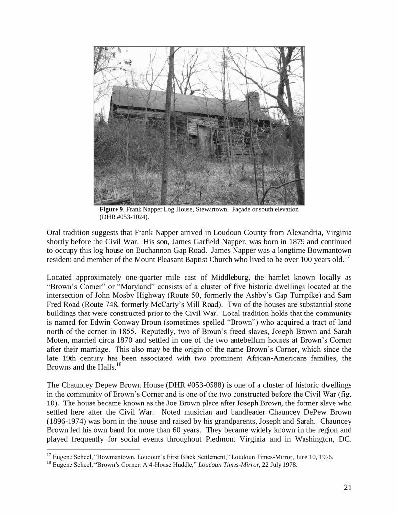
Figure 9. Frank Napper Log House, Stewartown. Façade or south elevation
(DHR #053-1024).
Oral tradition suggests that Frank Napper arrived in Loudoun County from Alexandria, Virginia
shortly before the Civil War. His son, James Garfield Napper, was born in 1879 and continued
to occupy this log house on Buchannon Gap Road. James Napper was a longtime Bowmantown
resident and member of the Mount Pleasant Baptist Church who lived to be over 100 years old.17
Located approximately one-quarter mile east of Middleburg, the hamlet known locally as
―Brown’s Corner‖ or ―Maryland‖ consists of a cluster of five historic dwellings located at the
intersection of John Mosby Highway (Route 50, formerly the Ashby’s Gap Turnpike) and Sam
Fred Road (Route 748, formerly McCarty’s Mill Road). Two of the houses are substantial stone
buildings that were constructed prior to the Civil War. Local tradition holds that the community
is named for Edwin Conway Broun (sometimes spelled ―Brown‖) who acquired a tract of land
north of the corner in 1855. Reputedly, two of Broun’s freed slaves, Joseph Brown and Sarah
Moten, married circa 1870 and settled in one of the two antebellum houses at Brown’s Corner
after their marriage. This also may be the origin of the name Brown’s Corner, which since the
late 19th century has been associated with two prominent African-Americans families, the
Browns and the Halls.18
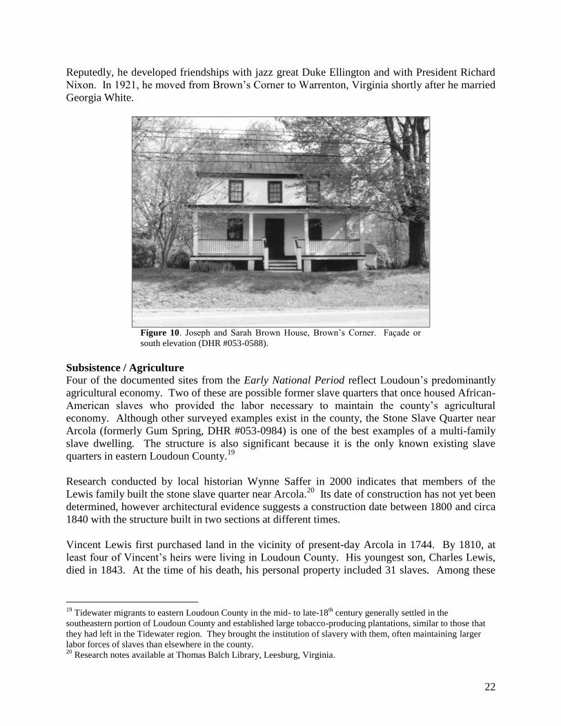
The Chauncey Depew Brown House (DHR #053-0588) is one of a cluster of historic dwellings
in the community of Brown’s Corner and is one of the two constructed before the Civil War (fig.
10). The house became known as the Joe Brown place after Joseph Brown, the former slave who
settled here after the Civil War. Noted musician and bandleader Chauncey DePew Brown
(1896-1974) was born in the house and raised by his grandparents, Joseph and Sarah. Chauncey
Brown led his own band for more than 60 years. They became widely known in the region and
played frequently for social events throughout Piedmont Virginia and in Washington, DC.
17
Eugene Scheel, ―Bowmantown, Loudoun’s First Black Settlement,‖ Loudoun Times-Mirror, June 10, 1976. 18
Eugene Scheel, ―Brown’s Corner: A 4-House Huddle,‖ Loudoun Times-Mirror, 22 July 1978.
22
Reputedly, he developed friendships with jazz great Duke Ellington and with President Richard
Nixon. In 1921, he moved from Brown’s Corner to Warrenton, Virginia shortly after he married
Georgia White.
Figure 10. Joseph and Sarah Brown House, Brown’s Corner. Façade or
south elevation (DHR #053-0588).
Subsistence / Agriculture
Four of the documented sites from the Early National Period reflect Loudoun’s predominantly
agricultural economy. Two of these are possible former slave quarters that once housed African-
American slaves who provided the labor necessary to maintain the county’s agricultural
economy. Although other surveyed examples exist in the county, the Stone Slave Quarter near
Arcola (formerly Gum Spring, DHR #053-0984) is one of the best examples of a multi-family
slave dwelling. The structure is also significant because it is the only known existing slave
quarters in eastern Loudoun County.19
Research conducted by local historian Wynne Saffer in 2000 indicates that members of the
Lewis family built the stone slave quarter near Arcola.20
Its date of construction has not yet been
determined, however architectural evidence suggests a construction date between 1800 and circa
1840 with the structure built in two sections at different times.
Vincent Lewis first purchased land in the vicinity of present-day Arcola in 1744. By 1810, at
least four of Vincent’s heirs were living in Loudoun County. His youngest son, Charles Lewis,
died in 1843. At the time of his death, his personal property included 31 slaves. Among these
19
Tidewater migrants to eastern Loudoun County in the mid- to late-18th
century generally settled in the
southeastern portion of Loudoun County and established large tobacco-producing plantations, similar to those that
they had left in the Tidewater region. They brought the institution of slavery with them, often maintaining larger
labor forces of slaves than elsewhere in the county. 20
Research notes available at Thomas Balch Library, Leesburg, Virginia.

23
slaves were members of the Turner, Sprawling, Hogan, Newman, Henderson, Owings, and
Simms families.21
Recently, the parcel on which the Arcola slave quarter stands was donated to the Loudoun
County Parks Department for use as parkland. Loudoun County has committed to restoring and
interpreting the former slave quarter. A non-profit group known as ―Friends of the Slave
Quarters‖ has been established to collect historical data and interpret the history of the Arcola
slave quarter.22
Figure 11. Walsh Farm Slave Quarter, Paxson/Berkley. West elevation
(DHR #053-5139).
According to local historian Eugene Scheel, another potential slave quarter stands on property
know today as the Walsh Farm (DHR# 053-5139), but historically owned by the Butcher family.
Its form is not typical of most slave quarters built in northern Virginia in the late 18th
century
(fig. 11). From the façade, the building appears to be a two-story, four-bay, single-pile stone
dwelling. Set into a hill, the house actually features a fully exposed basement story on the front
and a single story visible from the rear. It stands at the base of a hill atop which the original
―manor house‖ once stood. The main residence has been replaced with a turn-of-the-20th
-
century frame dwelling that now occupies the eminence. Other historic farm-related
outbuildings occupy this substantial farm complex.
The Raymond and Mattie Berryman property (DHR #053-0932) near Mountville (see details
above) also reflects Loudoun’s agricultural heritage and the continuity of that heritage from the
21
Saffer research notes, available at Thomas Balch Library, Leesburg, Virginia. 22
Thomas L. Hill, ―They were Here: Oral History Project of Charles Lewis Slave Descendants, Hutchinson’s Farm,
Arcola, Virginia (Formerly Gumsprings),‖ Brochure, no date. Jim Silver, ―Developments Erase Slavery’s Historic
Sites,‖ The Connection. January 31- February 6, 2001. , Jon Echtenkamp, ―Stones of Solace: Research May Reveal
History of a Slave Family,‖ Loudoun Times-Mirror, 4 November 1998.

24
18th
through the mid-20th
century. The barn and stable building that stands east of the house
reflects the agricultural activities of the owners. The acquisition of this substantial farm property
by an African-American family in 1922 reflects the economic success of some of Loudoun’s
black citizens and their participation in the county’s agricultural economy.
Antebellum Period (1831-1860)
Domestic
All nine of the surveyed resources for this period relate to the domestic theme and illustrate the
simple, often log- or stone-built dwellings that most working-class Loudouners lived in during
this time period. Examples of these include the circa-1840 Gracie Reid House (DHR #053-
0062-0005) in Howardsville, the circa-1850 Berkley Bowman House (DHR #053-0605-0010) in
Bowmantown, and the mid-19th
century residence at 34017 Welbourne Road (DHR #053-5116-
0008) in Willisville.
African-American families may have built two of the nine structures. One of these, the Berkley
Bowman House, is reputedly one of the earliest extant houses in the village of Bowmantown.
According to local sources, Jim and Frances Bowman built the original section of the house, a
one-story log structure that has been incorporated into the 2-story structure that stands on the site
today. Circa 1925, their grandson, Berkley Bowman who was a house carpenter by trade,
remodeled the original residence. Today, the house resembles a Late Victorian vernacular
building and is still owned by a descendant of Jim and Frances Bowman.23
The circa-1850 log house that stands at 15407 Ashbury Church Road is another rare example of
a dwelling that may have been built by free African Americans prior to the Civil War (DHR
#053-5205). The house retains many original features and several historic additions. A local
informant has indicated that the house’s most recent residents included members of the Smith
and Heywood families. The house is among five remaining historic buildings that were
associated with an early African-American community that is known as Short Hill (see Appendix
B).
The origins of the Gracie Reid House (DHR #053-0062-0005) in the African-American
community of Howardsville are unclear. Three African-American families settled the hamlet of
Howardsville in the 1870s. The Reid House may predate this settlement or it may have been
built shortly after the first settlers purchased property here. If the latter, then the house illustrates
the continuance of traditional building techniques into the third quarter of the 19th
century. By
this time, most affluent landowners were constructing frame or stone dwellings with chimneys
that accommodated narrow stove flues in place of what had become old-fashioned, full-size
wood-burning chimneys. However, because the purchase of a stove to heat the residence would
have required additional money, it is reasonable that families with limited cash reserves would
rely on traditional construction techniques and technologies. The Reid family moved to
Howardsville in the 1920s and continues to own and occupy this residence. The house is a good
example of a small, middle-class residence of the Antebellum Period (fig. 12). Its one-and-a-
23
Eugene Scheel, "Bowman Reflects Black History," Loudoun Times-Mirror, 16 January 1991; Scheel,
―Bowmantown, Loudoun’s First Black Settlement,‖ Loudoun Times-Mirror, 10 June 1976.

25
half-story, side gable form, weatherboard cladding, and massive exterior-end stone chimney
reflect a long building tradition that extends back to the 18th
century in Loudoun County.
Figure 12. Gracie Reid House, Howardsville. East and north elevations
(DHR #053-0062-0005).
The mid-19th
century residence at 34017 Welbourne Road (DHR #053-5116-0008) in Willisville
is another example of a modest frame residence that predates the African-American settlement of
the area. Although altered, the oldest portion of the building suggests a construction date of circa
1840. Willisville’s earliest African-American residents, Henson and Lucinda Willis purchased
the 3.75-acre property with an existing cabin for $100 in 1874.24
In 1870, Henson (or Hanson)
Willis (born circa 1820) worked as a plasterer and lived near the Bloomfield Post Office with his
wife Lucinda and their five children. By 1900, Henson had died and his widow ran the family
farm in Willisville. The Willis House is a good example of the modest frame and log dwellings
in which many African Americans in Loudoun County lived after emancipation. The house has
been expanded over the years to accommodate modern needs, but still exhibits its historic
characteristics.
The Hall Place (DHR #053-0589) in Brown’s Corner is another example of a residence that was
likely built for a white owner, but was later owned by African Americans. Built circa 1837, the
house is a good example of a typical antebellum stone house in western Loudoun County. By
1900, Nathan N. Hall, an African-American stonemason, lived in the house with his family.25
The current owners indicated that in the 1950s, when Nathan Hall’s sons Albert and Willie had
inherited the property, Albert lived here and rented rooms to four African-American families,
Harry & Annie Bushrod, Francis & Florence Swan, Stanley and Isabelle Baltimore (current
owners), and Alice Brown.
24
Scheel, ―Willisville History Dates to Pre-Civil War Era,‖ Loudoun Times-Mirror, 28 April 1983, A-14. 25
Scheel, ―Brown’s Corner: A 4-House Huddle,‖ Loudoun Times-Mirror, 22 July 1978.

26
Civil War (1861-1865)
No resources that date to this period were surveyed.
Reconstruction and Growth (1866-1916)
The majority of surveyed resources date to the Reconstruction and Growth Period
(approximately 67%). Of these, most relate to the Domestic Theme. The large number of
resources identified for this period reflects the methodology and scope of the project as defined
by the project sponsors. The Black History Committee of the Friends of the Thomas Balch
Library had collected information on the location of a number of predominantly African-
American towns, villages, hamlets, and neighborhoods from local informants and local histories.
The focus of the survey was to document the historic resources within these previously identified
locales. Most of these areas were settled after the Civil War, and thus their historic architectural
resources date from this period of settlement and growth. Many continued to grow, although
more slowly, after the Reconstruction and Growth Period. Thus, the second largest number of
surveyed resources is from the World War I to World War II period.
The surveyed resources express the variety of activities that took place in these communities,
including commerce, education, religious, funerary, and domestic activities. The following is a
discussion of the various historic resources found within Loudoun’s African-American
communities and the activities that relate to their construction.
Commerce/Trade
Four commercial historic resources demonstrate the architectural diversity of the rural and small-
town general store. The presence of these commercial enterprises within Loudoun’s African-
American communities also reflects the growth of entrepreneurship among African Americans
after the Civil War. These black-owned institutions served an important role in their
communities.
Located in the mix-raced Watson community, Watson General Store (DHR #053-0987), also
known as Mitchell’s or Church’s Store, is an excellent example of a turn-of-the-century rural
store serving the needs of a small Loudoun community. The one-and-a-half-story, front-gable
building was originally erected in 1888 by J.W. Mitchell, a local white merchant.
The unidentified former commercial building (now vacant) west of 242 Maryland Avenue in
Hamilton has several architectural features that identify it as a former store or workshop (DHR
#053-5191). Among these are its diminutive size and the large windows on the front-gable
façade that were probably used to display goods.
The circa-1890 commercial building at 35285 Snake Hill Road in St. Louis (DHR #053-5099-
0009) also exhibits characteristic commercial features. Its front-gable with stepped parapet form
and large front windows reveal its former use (fig. 13). Again, little is known about its origins
or ownership.

27
Figure 13. Store, 35285 Snake Hill Road, St. Louis. South and west
elevations (DHR #053-5099-0009).
Domestic
The vast majority of the resources surveyed for this period are dwellings where Loudoun’s
African-American citizens resided. The houses that were recorded range in size, style, and
materials; however, some common building techniques and forms can be seen.
Building Forms and Materials
A significant trend in residential construction among African Americans in Loudoun’s rural
communities during this period was the use of a relatively rare building form. A true, one-and-a-
half story building form was used in many of these post-Civil War communities. This side-gable
form incorporates heightened eaves that contain half-size, frieze windows. The higher eaves and
attic-story windows allow for expanded living space in the upper story and additional light.
Visually, this form looks larger than a standard one-story-plus-attic building, but smaller than a
true two-story structure. This building form is generally associated with working- and middle-
class rural dwellings and has been associated with Pennsylvania-German settlers in the area.26
Among the surveyed resources, this form appears in log, frame and stone construction. The one
stone example may pre-date the Reconstruction and Growth Period. Located near Berryman in
south-central Loudoun County, this vacant, true, one-and-a-half-story, stone house sits west of
the end of Berryman Lane (Route 747). According to oral sources, it may have been the home of
Maude Smith during the early 20th
century (DHR #053-6037). Smith was African American.
The house consists of a two-bay-wide stone section and a two-bay-wide log section, both of
which appear to date to circa 1850.
26
Christopher Fennell, Log House Architecture in the Eighteenth-Century Virginia Piedmont, Available online at
http://etext.lib.virginia.edu/users/fennell/highland/harper/demoryarch.html.

28
Surveyed examples of true, one-and-a-half-story houses were typically constructed of log or
frame and stand in or near one of the 30 documented African-American towns, villages, hamlets
or neighborhoods. One of the most intact samples of the form stands on the east slope of Bull
Run Mountain in the community of Bowmantown (DHR #053-0605-0004). Little is known
about the dwelling’s origins, but it may have been erected by one of Bowmantown’s early
settlers. Built circa 1870, the house has original weatherboard cladding and a massive stone
chimney on its southwest gable end. The house is covered by a side-gable, standing-seam metal
roof and the symmetrical façade features half-sized, six-light frieze windows in the second story
(fig. 14).
Figure 14. House, 23965 New Mountain Road, Bowmantown. Façade or
southeast elevation (DHR #053-0605-0004).
Another good early example of this style stands at 18556 Foggy Bottom Road in the hamlet of
Murphy’s Corner (DHR #053-1060). Known as the Beatrice Scipio House, this true 1-1/2 story
log structure with V-notched corners dates to circa 1870. It was reputedly built by Christopher
Scipio who, according to a local historian, was born into slavery in 1851. Scipio married Rose
L. Jackson in 1874 in Loudoun County and built this log dwelling shortly thereafter. One of
Christopher and Rose’s children was Beatrice Scipio (1892-1978) who earned a teaching degree
from Storer College in Harper’s Ferry, West Virginia in 1910. Shortly thereafter she began a 46-
year teaching career, during which she taught at the Bluemont ―Colored‖ School on the mountain
near Butcher’s Branch until it closed in 1933. Later she taught at the George Washington Carver
School in Purcellville where she ended her teaching career in 1957. Scipio was well respected in
her community and frequently taught children in her home. In addition to teaching, Scipio
served as the music director and longtime deaconess of the First Baptist Church of Bluemont.
She died in 1978 and was buried in the Scipio family plot in the Rock Hill Cemetery north of
Unison.
29
Another example of a true one-and-one-half-story house still remains in the African-American
village of St. Louis (DHR #053-5099-0011). Located at the intersection of Snake Hill and St.
Louis Roads, the house was built circa 1870. It is known locally as the ―Madison House.‖ This
stuccoed frame house again displays extended height to the eaves so that the distance from the
top of the first floor to the eave line equals one-half the distance from the foundation to the top of
the first floor. Unlike other examples, the house does not incorporate attic-story windows on its
façade; only gable end windows light the upper story.
The majority of the houses later in the period are of frame construction and exhibit the
traditional, vernacular I-house form that proliferated throughout rural Virginia after the mid-19th
century. In Loudoun County, rural examples of the I-house form appear as late as the 1930s.
The I-house is a two-story, side-gable, single-pile (one-room-deep) house with a ground-floor
plan that consists of a single room on either side of a central hall. I-houses often feature a full-
width or nearly full-width front porch that frequently incorporates the only apparent architectural
styling on the house.
Figure 15. Brown Family House, Macsville. North and west elevations
(DHR #053-5151).
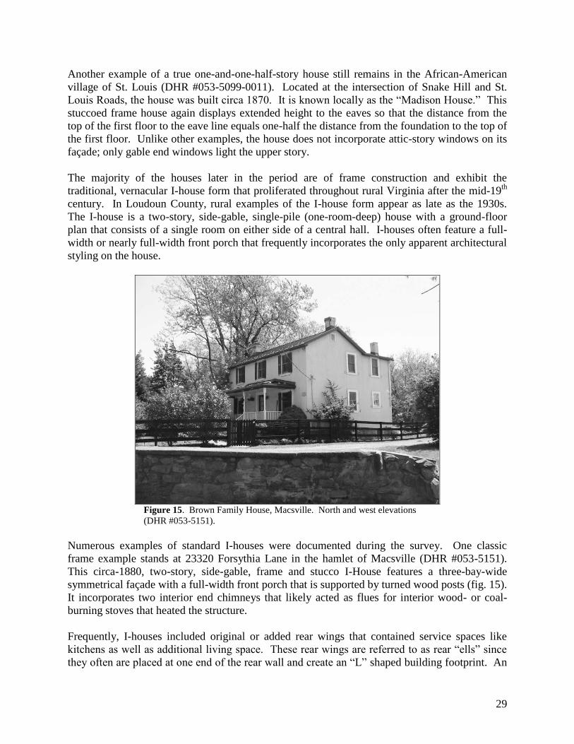
Numerous examples of standard I-houses were documented during the survey. One classic
frame example stands at 23320 Forsythia Lane in the hamlet of Macsville (DHR #053-5151).
This circa-1880, two-story, side-gable, frame and stucco I-House features a three-bay-wide
symmetrical façade with a full-width front porch that is supported by turned wood posts (fig. 15).
It incorporates two interior end chimneys that likely acted as flues for interior wood- or coal-
burning stoves that heated the structure.
Frequently, I-houses included original or added rear wings that contained service spaces like
kitchens as well as additional living space. These rear wings are referred to as rear ―ells‖ since
they often are placed at one end of the rear wall and create an ―L‖ shaped building footprint. An

30
I-house with an original rear ell stands at 22326 St. Louis Road in the community of St. Louis
(DHR #053-5099-0017). Currently vacant, the circa-1900, two-story, stuccoed frame house
exhibits the classic, three-bay-wide, one-room-deep I-house form and incorporates a 2-story,
stuccoed-frame rear ell.
A common decorative feature seen on vernacular I-houses throughout Virginia appears on
several of Loudoun’s domestic buildings. Centered front gables, possibly derived from the
Gothic Revival style that originated in the mid-19th
century, frequently adorn and reinforce the
symmetrical I-house form. This feature is apparent at the Mary Jane Jackson House in St. Louis
(DHR #053-5099-0004). As is often the case, a small four-light casement window fills the
pediment created by the centered front gable.
Vernacular I-houses exist in many of Loudoun’s African-American residential enclaves,
including the Nicolas Beaner House (circa 1890, DHR #291-5009) in Round Hill, 33973
Welbourne Road (circa 1890, DHR #053-5116-0003) in Willisville, the house at 258 Maryland
Avenue in Hamilton (circa 1880, DHR #053-5190), and the house at 20991 Greengarden Road
(circa 1880, DHR #053-0062-0006) in Howardsville. The Greengarden Road example is
unusual because it includes relatively small window openings and a double-flue, stone exterior
end chimney. This indicates that the house was originally heated by open, wood burning hearths
as opposed to the more technologically advanced coal- and wood-burning stoves that were
typical of the period.
A modified I-house form also appears frequently among the domestic resources of this period.
This form resembles the vernacular I-house, but is narrower in width. The modified I-house
interior floor plan likely omits the center hall but retains the two single-pile rooms and centered
entrance of a traditional I-house.
Figure 16. House, 20058 Sycolin Road, Sycolin. Façade or west elevation
(DHR #053-5215).

31
A good example of this condensed I-house form occupies a two-acre lot near the community of
Sycolin. The circa-1900 house at 20058 Sycolin Road (DHR #053-5215) features a three-bay
façade with a centered entrance (fig. 16). Judging from the house’s width, the interior does not
include a center stair hall. The second story includes only two windows, suggesting a one or
two-room second floor. As with standard I-houses, a full-width front porch with Victorian-style
turned wood posts fronts the building. The house is clad in wood, German-style siding that was
enormously popular in the early 20th
century. German siding was one of several ―novelty‖
sidings that could be purchased from milling companies that specialized in pre-milled
woodwork. After the advent of the railroad in the 1830s, these products became widely available
throughout Virginia. By the 1870s, standardized lumber available via railroad greatly affected
the style and forms of town and rural buildings throughout the state.
Another example of the condensed I-house stands in Hamilton’s predominantly African-
American neighborhood. The Lindsay Gaskins House at 102 Delaware Avenue (DHR #053-
5189) was built circa 1870. Its current configuration may reflect later, circa-1900 alterations. Its
narrow, side-gable, single-pile form again suggests a one- or two-room first floor plan, however,
the centered entrance and flanking windows relate to the typical I-house form. The house also
replicates the rear ell form, except the ell becomes a full-width, cross-gable extension at the rear.
The house exhibits Late Victorian-era styling. Its only decorative elements are the turned wood
posts that support its full-width front porch.
Another common construction practice illustrated by the surveyed resources is the frequent
accretions made to existing houses. Most owners chose to expand and reconfigure existing
dwellings when they needed more space rather than demolish and rebuild. One house that
reflects this trend is the Jim Henderson House at 8 High Street in Round Hill (1900, DHR #291-
5001). This vernacular frame residence consists of two, nearly equal halves that were built at
different times (fig. 17). In fact, when expanding the residence, the owner chose to simply
replicate the two-bay, two-story, side-gable form instead. This technique required minimal
alteration of the existing floor and may have allowed for the accommodation of a separate
extended family or boarders.

32
Figure 17. Jim Henderson House, Round Hill. Façade or north elevation
(DHR #291-5001).
Architectural Styles
Very few of the residences that were surveyed for this time period are pure examples of a single
architectural style. Most are instead expressions of traditional vernacular building techniques
and forms that occasionally incorporate modest architectural decoration. The more elaborate
expressions of architectural style reside generally in Loudoun’s larger towns, including
Purcellville, Round Hill, Hamilton, and Lovettsville. This may reflect greater relative wealth or
greater access to skilled craftsmen and standard lumber and millwork. This trend is apparent
throughout Loudoun County.
Several examples of houses with relatively higher levels of architectural sophistication appear
within the towns that were surveyed. These include the substantial Late Victorian style
residence at 330 G Street, East in Purcellville (fig. 18, DHR #286-5001-0231).

33
Figure 18. House, 330 G Street, Purcellville. Façade or north elevation
(DHR #286-5001-0231).
Several examples that stand in Hamilton include the Mount Zion Methodist Episcopal Church’s
parsonage (1890, DHR #053-5183), the substantial frame and stucco Collins House at 70
Laycock Street (circa 1900, DHR #053-5184), the double I-house Clint Gaskins House at 112
West Virginia Avenue (circa 1900, DHR #053-5196), and the Fannie Harvey House at 119 North
Ivandale Road (1890, DHR #053-5186).
Other examples of architectural styling appear outside of Loudoun’s incorporated towns. The
Brent House on Cooksville Road in Lincoln (DHR #053-0843) was built in 1874 and includes
simple Italianate Style features such as the round-headed windows in the centered front gable
and in the gable ends and the projecting window bays.

34
Figure 19. House, 24060 New Mountain Road, Bowmantown. North and
west elevations (DHR #053-0605-0007).
One thoroughly styled Queen Anne house (DHR #053-0605-0007) dates to 1909 and stands in
the village of Bowmantown. Located at 24060 New Mountain Road, this residence features both
the typical cross-gable form of a Queen Anne-style house and specific stylistic features such as
the wraparound porch, bracketed turned post porch supports, and a square, multi-light Queen
Anne-style window (fig. 19).
Stylistic details on other buildings appear as isolated details on otherwise vernacular house
forms. A good example of this common treatment is the house at 22256 Newlin Mill Road in St.
Louis (DHR #053-5099-0014). Built circa 1890, the house is a standard example of a vernacular
I-house with an addition. The only decorative detailing appears on the three-bay front porch,
that incorporates high, Victorian-style scroll-sawn brackets and turned wood posts.

35
Figure 20. House, 34090 Snickersville Turnpike, Murphy’s Corner. East
and north elevations (DHR #053-5141-0003).
While the vast majority of stylistic embellishments seen in the surveyed buildings are related to
the Victorian and Late Victorian styles, there are a handful of other styles represented. Among
these are the Bungalow-Craftsman Style as seen in the circa-1900, two-and-a-half-story, front-
gable, stuccoed-frame house at 34090 Snickersville Turnpike in Murphy’s Corner (DHR #053-
5141-0003). The house has a traditional front gable form, but exhibits 3-over-1 double-hung
sash windows and a Craftsman-style multi-light door, as well as shingles in the front gable (fig.
20). An early example of the Colonial Revival style exists at 17471 Brownsville Lane in
Brownsville (Swampoodle) (circa 1910, DHR #053-5176-0008). The front-gable, frame house
incorporates simple classical features including corner pilasters and a raking cornice.
Another Colonial Revival-style dwelling included in the survey may be associated with
Loudoun’s most prominent African-American builder, William N. Hall.27
The house stands at
23381 Sam Fred Road in Brown’s Corner and consists of an older and smaller stone house that
was greatly expanded and re-styled circa 1910 (DHR #053-5150). Today the dwelling exhibits
Colonial Revival stylistic features, including prominent gabled ends with cornice returns and an
elaborate classical porch (fig. 21).
27
William Nathaniel Hall (1890-1958) was a successful African-American businessman in Loudoun County. Willie
Hall ran a contracting business that employed as many as 30 people and constructed several local buildings
including the Middleburg National Bank, a wing of the Presbyterian church in Leesburg, and an addition to the
Leesburg Hospital. Born in Middleburg to Cornelia and Nathan N. Hall, Hall learned the stonemason’s trade from
his father. His two sons joined him in his contracting business, forming W.N. Hall and Sons, Inc. In addition to his
contracting work, Hall was active in real estate, owning more than 30 properties in and around Middleburg. He was
a shareholder and board member of the Loudoun County Emancipation Association, a deacon at Shiloh Baptist
Church in Middleburg, and a trustee of Aberdeen Lodge No. 1557 of the Grand United Order of Odd Fellows. The
Essence of a People: Portraits of African Americans Who Made a Difference in Loudoun County, Virginia
(Leesburg, VA: Black History Committee of The Friends of the Thomas Balch Library, 2001), pp. 32-33.

36
Figure 21. House, 23381 Sam Fred Road, Macsville. South and east
elevations (DHR #053-5150).
Education
The pursuit of education was a significant organizing force among African Americans after the
Civil War. In 1870, Virginia’s new constitution required that public schools be established for
both whites and blacks. By 1871 there were 46 white schools and 9 African-American schools
in Loudoun County.28
Throughout the late 19th
and first half of the 20th
centuries, Loudoun’s
African-American schools were funded at lower levels and given fewer supplies and resources
than the county’s white schools. In fact, many of the black schools would never have been
established if local African-American residents had not petitioned and persisted in acquiring
land, materials, money, and labor to build them. Several of Loudoun’s most established African-
American communities organized to advocate for public schools in their communities. Despite
these efforts, inequality between the black and white school systems in the county continued well
into the 20th
century.
According to church histories, Lincoln’s Grace Methodist Episcopal Church was established in
the former Lincoln ―Colored‖ School on Cooksville Road in 1872 (DHR #053-0845, fig. 22).
This suggests that the building, or a portion thereof, was the school that the Society of Friends
started for African Americans in 1865 just after the Civil War. Records of the Bureau of
Refugees, Freedmen and Abandoned Lands (better known as the Freedmen’s Bureau) show that
a school known as ―Lincoln‖ was operating by August 1866. It was variously known as the
―Lincoln,‖ ―Janney,‖ and ―Tate‖ school. A white teacher, Clara Connelly, served the school
between 1866 and 1869.
28
Poland, p. 250, fn 137. In 1871, there were 6,644 school-aged children in Loudoun County; 1,831 were African
American.

37
Figure 22. Lincoln ―Colored‖ School. East and north elevations (DHR
#053-0845).
The school was one of about thirteen African-American schools that operated in Loudoun
County between 1865 and 1870, before a statewide public school system was established in
Virginia in 1871. Many of these schools were privately supported through northern religious
groups such as the Friends Association of Philadelphia and the Presbyterian Association of New
York.29
The two-story, front-gable former schoolhouse consists of a random rubble stone first
story surmounted by a frame second story. It is not known whether the second-story is original
or a later addition. The stone first story features large stone quoins at the corners and three
window bays along each of its flanks. Its windows feature narrow wood lintels. A single
entrance topped by a three-light transom stands on the southeast gable end.
The Lincoln ―Colored‖ School with its stone construction and two-story form was not typical of
Loudoun’s African-American schoolhouses. Typically, those built after 1870 were simple,
rectangular buildings with front gable roofs. They contained one room that was accessed by a
single-leaf front door on the gable end and they were lit by two or three windows per flank.
The Brownsville Schoolhouse (DHR #053-5176-0002) is a good example of the public school
buildings that were used by African Americans during this period. It was standing by 1887 when
the Jefferson and Mt. Gilead School Districts purchased it and the surrounding acre of land from
local landowners William H. and Marion P. Brown. Between 1887 and 1925, the building was
used for the education of the African-American children from the two adjacent public school
districts. Teachers who taught there included Robert Tyler, Alma Saunders, Rev. Adolph
Haines, and Walter Brown. Brown lived nearby and was the last teacher to serve the
Brownsville school before it closed in 1925. After the school was closed, the building was
converted into a house and has served as such ever since. Although somewhat altered, its basic
form, original stone foundation, and some of the original window openings are still visible.
29
Records of the Bureau of Refugees, Freedmen, and Abandoned Lands, 1861-79, National Archives and Records
Administration, Record Group 105. 105.3.9 Records of the Education Division, 105.5 Records of Field Offices.

38
Figure 23. Hillsboro ―Colored‖ School (former), Short Hill. South and
east elevations (DHR #053-5206).
The Hillsboro ―Colored‖ School stands south of the town of Hillsboro in a historically African-
American enclave known as Short Hill (DHR #053-5206, fig. 23). The circa-1890 frame school
was built to serve the African-American community in and around the town of Hillsboro. The
present building may have replaced an earlier log structure that is said to have stood near the
Asbury Methodist Episcopal Church (see DHR architecture #053-0909 and archaeology
#44LD0924). Freedmen’s Bureau Records indicate that, by March 1869, there was a school for
African Americans located near Hillsboro with 40 students enrolled.30
At that time, African-
American educator Robert L. Mitchell served as the school’s teacher. Currently used as a
residence, the school remains in good condition and is one of the most intact examples of the
African-American schoolhouses in Loudoun County.
Frequently, Loudoun’s African-American churches were closely linked with educational
institutions. At least two of the 19 churches that were surveyed were used as schoolrooms as
well as for religious services. The frame, one-room Antioch Methodist Episcopal Church in
Lovettsville (DHR #053-0697) served for many years as the local African-American
schoolhouse. The circa-1900 New Zion Baptist Church (DHR #053-5086) was originally
erected as a one-room school for African Americans near the communities of Marble Quarry and
Berryman. In 1973, the congregation of Mount Zion Baptist Church of Marble Quarry
purchased the former school building and converted it into their church.
The former Bull Run School (DHR #053-0605-0003), now a residence, was the last school built
during the period. Erected in 1909 as a replacement for a circa-1890 school that burned in 1898,
the present structure was a typical one-room frame, front-gable schoolhouse. Named Bull Run
School after its location on the east slope of Bull Run Mountain, the 1909 schoolhouse served
30
Ibid.

39
the community’s education needs for 50 years. Records indicate that the school was closed in
1959.
Funerary
There at least 34 documented African-American cemeteries in Loudoun County (see Appendix C
– Cemetery List.) During the survey, six cemeteries that date to the period of Reconstruction
and Growth were identified. Because the survey focused on the 30 pre-identified African-
American communities, most of the documented cemeteries have religious affiliations. Their
earliest marked graves range in date from circa 1880 to 1914.
Religion
Between 1864 and 1900, Loudoun citizens formed 30 African-American churches. Eleven were
affiliated with the national Methodist Episcopal Church, while the remainder were independent
Baptist, African Methodist Episcopal, or Colored Methodist Episcopal congregations. These
institutions quickly became the center of African-American society in Loudoun. They served as
political, religious, and social outlets and provided support, aid, and education for community
members.31
Of the 24 historically African-American churches that were recorded during the survey, 16 were
erected during this period. This reflects the period of greatest growth for the African-American
communities in Loudoun County. The 16 churches range from modest, one-room, frame
sanctuaries to more elaborate, Gothic Revival-style stone and frame churches. However, most
are single or two-room structures with minimal decorative detailing. Details are mainly
restricted to the windows and steeples or bell towers.
The earliest surveyed church buildings generally began as one-room frame buildings that were
later expanded. 32
One example is Mount Pleasant Baptist Church near Lucketts in north-central
Loudoun County (DHR #053-0322). In 1880, Reverend Charles Hadley and about a dozen
residents in the Lucketts vicinity organized the Mount Pleasant Baptist Church. Local builder
Jewel Frye built the church on land donated by Martha Ambers Thomas. The present building
consists of the original 1880 one-story, side-gable section at the rear of the church and a front-
gable addition that was added in 1915 to accommodate the church’s growing congregation. Both
sections feature open eaves and cornice returns. An enclosed belfry with square louvered vents
is part of the 1915 addition and stands on the southeastern corner of the gabled roof (fig. 24).
31
Elaine E. Thompson, Guest Curator, ―’Courage, My Soul,’ Historic African American Churches and Mutual Aid
Societies,‖ An Exhibition at the Loudoun Museum, February 13-April 30, 2000, pp. 2-3. 32
The earliest church structures do not necessarily reflect the earliest African-American congregations. Many of the
early congregations originally worshipped in pre-existing buildings, in homes, schools, or outdoors.

40
Figure 24. Mount Pleasant Baptist Church, Lucketts. East and north
elevations (DHR #053-0322).
One of the simplest forms found among the surveyed church buildings is the former Antioch
Methodist Church in Lovettsville (DHR #053-0697). Prior to 1868, residents of Lovettsville and
the surrounding area organized a Methodist Episcopal congregation. On August 11, 1868, the
church trustees purchased a lot at the northwestern end of the town where Broad Way intersected
with the Berlin Turnpike. Around 1875, the lot was labeled on a town plat as the ―African
Chapel‖ lot. The circa-1880, one-story frame, front-gable building that occupies the site today
may have replaced an earlier structure. The building served both as a chapel and as a school
building for African-American children in the community. The site also contains a cemetery
with marked graves that date back to 1890.
In contrast to the modest size and simple décor of the Lovettsville church, the still-active Mount
Zion Baptist Church in Round Hill is a relatively large and elaborate Gothic Revival-style church
that is located on a prominent lot in the center of town (DHR #291-5011). Built in 1881 on a
quarter-acre lot that trustees Chester Lewis, Nelson McKinney, and Nelson Jones purchased
from Barney Noland that year, this frame, one-story church is an excellent example of a typical
African-American church from the late 19th century. The church exhibits stylish Gothic Revival
features, including the pointed belfry and peaked-arch windows. One of the original kerosene
lamps still hangs in the sanctuary and the wrought iron fence at the front of the lot is believed to
be original as well.

41
Figure 25. Mount Pleasant Baptist Church,
Bowmantown. Façade or east elevation (DHR #053-
1023).
Another carefully detailed frame church is Mount Pleasant Baptist Church (DHR #053-1023) in
Bowmantown (fig. 25). Although no longer in use, the 1-story, front gable church retains most
of its original features. It is an excellent example of a modest rural church of the period. In the
early 1870s, a group of African-American residents that lived in and around present-day
Bowmantown began meeting for religious services that were presided over by traveling ministers
and other local religious leaders. In 1875, Thomas Edmonds organized the Mount Pleasant
Baptist Church at Bowmantown. Early officers and senior members of the church were John
Allen, Benjamin Allen, Charles Murray, Sr., Julia Haney, and Maury Allen. The first church
building was constructed not long after the founding of the congregation. Built of log, the first
sanctuary reputedly stood just south of the existing church on New Mountain Road. According
to the building's cornerstone, construction of Mt. Pleasant Baptist Church was either completed
or begun July 31, 1887.
The former Mount Olive Methodist Episcopal Church in Gleedsville (now the Unitarian
Universalist Church of Loudoun) is another well-preserved example of a late-19th
century
African-American church (DHR #053-0994). According to a written church history, Mount
Olive M.E. Church derived its name from the similarity of local terrain to the mile-long Mount
Olive ridge east of Jerusalem in Israel.33
The local ridge rises to a height of 505 feet and is
33
Eugene Scheel, ―Gleedsville Named After Ex-Slave,‖ Loudoun Times-Mirror, 7 April 1977.

42
called Negro Mountain, named for the free African-Americans who settled there before the Civil
War. John Gleed was one of the founding members of the church and of the surrounding
community of Gleedsville. On January 3, 1889, the congregation purchased a half-acre lot from
Washington and Margaret Thornton to build a chapel that was erected across Route 650
(Gleedsville Road, formerly Carter’s Mill Road) from John Gleed’s home place (which
reportedly burnt down in the early 1920’s). The Mount Olive congregation was active for nearly
100 years before it merged with Mt. Zion United Methodist in Leesburg in the mid 1980’s. The
church retains its original rectangular footprint, its pointed-arch, Gothic Revival-style windows,
and its original cladding that consists of German siding and variegated shingles in its front gable.
Stone was a popular building material, especially in western Loudoun County where it was
readily available and where many local stonemasons worked. Most of the 16 churches from the
period sit upon random-rubble stone foundations, while three are entirely constructed of stone.
Figure 26. Grace Methodist Episcopal Church, Lincoln. South and east
elevations (DHR #053-0205).
The former Grace Methodist Episcopal Church (DHR # 053-0205) in Lincoln is an excellent
example of a late-19th
century stone chapel (fig. 26). Founded circa 1872 in Lincoln, Virginia
under the leadership of Rev. Henry Carroll, services were originally held in the village’s African
-American schoolhouse (see DHR #053-0845). In December 1884, church trustees, Oscar Carry,
Jesse Palmer, George Parker, John Lewis, and James R. Hicks purchased a half-acre lot in
Lincoln from Mary E. Birdsall.34
The cornerstone of the present stone church was laid on July
30, 1885.
Many of the early members of the church came from the Thomas, Cooper, Brady, Lewis, Carey,
Gordon, Dade, Simms, Bell, Furr, Moore, Coates, Hicks, Henderson, Cook, and Mitchell
34
Loudoun County Deed Book 6-W, p. 483.
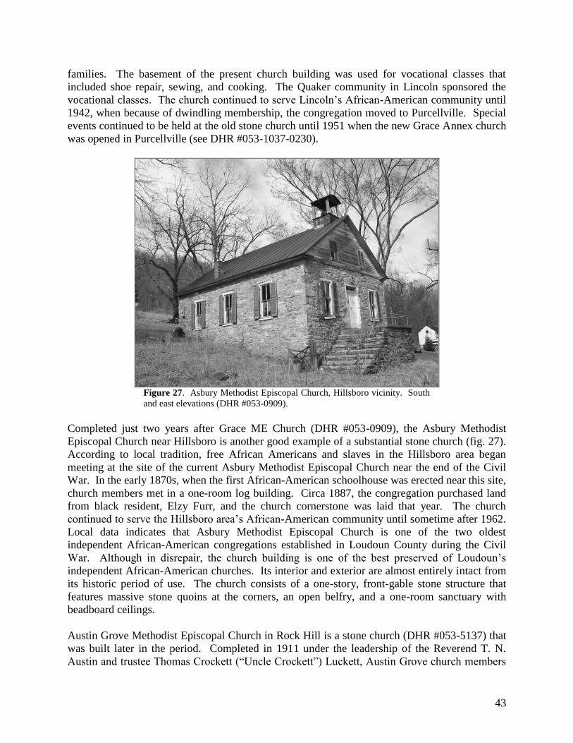
43
families. The basement of the present church building was used for vocational classes that
included shoe repair, sewing, and cooking. The Quaker community in Lincoln sponsored the
vocational classes. The church continued to serve Lincoln’s African-American community until
1942, when because of dwindling membership, the congregation moved to Purcellville. Special
events continued to be held at the old stone church until 1951 when the new Grace Annex church
was opened in Purcellville (see DHR #053-1037-0230).
Figure 27. Asbury Methodist Episcopal Church, Hillsboro vicinity. South
and east elevations (DHR #053-0909).
Completed just two years after Grace ME Church (DHR #053-0909), the Asbury Methodist
Episcopal Church near Hillsboro is another good example of a substantial stone church (fig. 27).
According to local tradition, free African Americans and slaves in the Hillsboro area began
meeting at the site of the current Asbury Methodist Episcopal Church near the end of the Civil
War. In the early 1870s, when the first African-American schoolhouse was erected near this site,
church members met in a one-room log building. Circa 1887, the congregation purchased land
from black resident, Elzy Furr, and the church cornerstone was laid that year. The church
continued to serve the Hillsboro area’s African-American community until sometime after 1962.
Local data indicates that Asbury Methodist Episcopal Church is one of the two oldest
independent African-American congregations established in Loudoun County during the Civil
War. Although in disrepair, the church building is one of the best preserved of Loudoun’s
independent African-American churches. Its interior and exterior are almost entirely intact from
its historic period of use. The church consists of a one-story, front-gable stone structure that
features massive stone quoins at the corners, an open belfry, and a one-room sanctuary with
beadboard ceilings.
Austin Grove Methodist Episcopal Church in Rock Hill is a stone church (DHR #053-5137) that
was built later in the period. Completed in 1911 under the leadership of the Reverend T. N.
Austin and trustee Thomas Crockett (―Uncle Crockett‖) Luckett, Austin Grove church members

44
reputedly built the church in their spare time, using stone that they gathered from nearby fields.
Between 1940 and 1976, this volunteer tradition of construction continued when church
members built an addition to the church to use as an education building. The building consists of
a basic rectangular form built in stone with frame gable ends. A later stone vestibule extends off
the front gable end.
There are several other African-American churches throughout the county that were documented.
They generally are part of the formal and architectural categories explained above.
Social
The only building identified during the survey that reflects the social theme was Watson Hall
(DHR #053-5087-0003). The mixed-race Watson community acquired a white Christian
congregation early in the 20th
century. Known as the ―Watson Mountain Church,‖ the institution
was affiliated with the Presbyterian denomination. Beginning in 1906, John William Mitchell,
then owner and operator of the Watson store, led efforts to establish the church. In 1913,
Mitchell’s efforts culminated in the construction of a frame chapel, long known as ―The Hall.‖
The building acted as a community center and social hall for local residents. Church services
were held twice a month on Sundays. Services ceased in the late 1930s.35
It is unclear whether
black residents of Watson used Watson Hall. Today, the one-story, front-gable, frame building
has been converted for use as a dwelling. It stands near the north end of the village at 22529
Watson Road (Route 860).
Subsistence / Agriculture
Although the scope and method that was established for the survey limited the number of rural
agricultural properties that were documented, a few surveyed resources reflect the increase in
land ownership and farming activities among Loudoun’s African Americans after the Civil War.
Despite many obstacles, land ownership and farming by formerly enslaved people and their
descendents continued to grow at a sometimes-astounding rate in the late 19th
and the early 20th
century in Virginia. According to historian Loren Schweninger, ―former slaves and their
children in Virginia became almost obsessed with the idea of acquiring their own land.‖36
As a
result, between 1870 and 1910 black farm ownership in Virginia rose 3,641 percent, from 860 to
32,168 black farm owners. Schweninger attributes the extraordinary rise in property ownership
among Virginia’s African Americans to a variety of conditions. Among these was a
longstanding tradition of black proprietorship in the state, increased opportunities to acquire
mortgage money, the establishment of a variety of race-based mutual aid societies, the promotion
of ideas of ―enterprise and self-sufficiency‖ by Virginia’s Hampton Institute, and the efforts of
African-American Virginians such as Congressman John Mercer Langston, editor John Mitchell,
and banker Maggie Walker to encourage property ownership.37
The Nokes property at 45564 Thayer Road (DHR #053-5223) near Sterling is a good example of
a modest farmstead owned and operated by an African-American family who acquired it after the
Civil War (fig. 28). According to family matriarch Elizabeth Nokes, her family moved to this
35
Eugene Scheel, ―Watson Community Gained Store, Post Office in 1888,‖ Loudoun Times Mirror, 27 May 1982. 36
Loren Schweninger, Black Property Owners in the South, 1790-1915 (Chicago: University of Illinois Press,
1997), p. 173. 37
Schweninger, pp. 173-174.
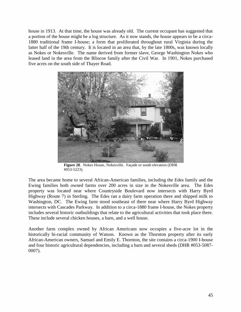
45
house in 1913. At that time, the house was already old. The current occupant has suggested that
a portion of the house might be a log structure. As it now stands, the house appears to be a circa-
1880 traditional frame I-house; a form that proliferated throughout rural Virginia during the
latter half of the 19th century. It is located in an area that, by the late 1800s, was known locally
as Nokes or Nokesville. The name derived from former slave, George Washington Nokes who
leased land in the area from the Blincoe family after the Civil War. In 1901, Nokes purchased
five acres on the south side of Thayer Road.
Figure 28. Nokes House, Nokesville. Façade or south elevation (DHR
#053-5223).
The area became home to several African-American families, including the Edes family and the
Ewing families both owned farms over 200 acres in size in the Nokesville area. The Edes
property was located near where Countryside Boulevard now intersects with Harry Byrd
Highway (Route 7) in Sterling. The Edes ran a dairy farm operation there and shipped milk to
Washington, DC. The Ewing farm stood southeast of there near where Harry Byrd Highway
intersects with Cascades Parkway. In addition to a circa-1880 frame I-house, the Nokes property
includes several historic outbuildings that relate to the agricultural activities that took place there.
These include several chicken houses, a barn, and a well house.
Another farm complex owned by African Americans now occupies a five-acre lot in the
historically bi-racial community of Watson. Known as the Thornton property after its early
African-American owners, Samuel and Emily E. Thornton, the site contains a circa-1900 I-house
and four historic agricultural dependencies, including a barn and several sheds (DHR #053-5087-
0007).

46
World War I to World War II (1917-1945)
The period between the United States’ entry into World War I and the end of World War II
witnessed continued growth in Loudoun County’s African-American communities, albeit at a
slower rate. Despite the obstacles presented by war and the Great Depression of the 1930s, 42
buildings were erected during this period in the towns, villages, hamlets and neighborhoods that
were surveyed.
Commerce/Trade
A number of black-owned businesses were formed and grew into significant local institutions
during this period. Among these was the construction business of William Nathaniel Hall (1890-
1958) who was a very successful businessman in Loudoun County. Willie Hall ran a contracting
business that employed as many as 30 people and was responsible for the construction of several
local buildings including the Middleburg National Bank, a wing of the Presbyterian church in
Leesburg, and an addition to the Leesburg Hospital. Other Loudoun entrepreneurs included
Howard Willard Clark, Sr. (1876-1960) who ran an ice cream parlor open to blacks in Hamilton,
and Thomas Robinson (1855-1912) the owner of a barbershop in Leesburg.
Figure 29. (Left) Fisher House, Macsville. East and north elevations (DHR #053-5152). (Right) Fisher
Workshop. North and east elevations (DHR #053-5152).
Only two resources associated with commerce were identified for this period. One is Corum’s
Store in Bowmantown (DHR #053-0605-0011). Built circa 1920 and later expanded and altered,
the store was operated by Neal Corum from 1931 until sometime after 1976 when it closed. The
other commercial resource is the Fisher workshop (DHR #053-5152) in Macsville, where, in
1930, Clarendon C. Fisher ran his own shoemaker’s shop (fig. 29). Although altered, the two-
story workshop is a rare example of an extant commercial building among the African-American
communities of Loudoun.

47
Domestic
During the war and inter-war period, house architecture in Loudoun County became more
closely linked to national styles and building trends. This was because of the greater availability
of standardized lumber, the proliferation of ―kit houses,‖ and the rise in commercial developers
and building contractors. Still, traditional house forms persisted as can be seen in the standard
frame I-house built at 40710 Red Hill Road in Watson in 1920 (DHR #053-5087-0006). Despite
the presence of several examples of this architectural continuity, other forms and styles began to
dominate residences that were built after 1920.
Figure 30. House, 33960 Welbourne Road, Willisville. Façade or south
elevation (DHR #053-5116-0013).
One common form of the period consists of a simple, low-pitched, front-gable roofed house that
may incorporate detailing borrowed from the Craftsman or Colonial Revival styles. The
stuccoed-frame, one-and-a-half-story house at 33960 Welbourne Road (DHR #053-5116-0013)
in Willisville demonstrates this modest form that relates to the rise of the Bungalow as an
inexpensive and practical house type during the 19-teens and 1920s (fig. 30). The bungalow was
an extremely popular early-20th
century house type that developed during a period when home
ownership among the middle and working class in the United States grew exponentially.
Bungalows were designed to be inexpensive to build and easy to maintain without hired help. A
typical bungalow is one- to one-and-a-half stories in height, has a compact, rectilinear footprint,
and features a full-width front porch, wide eaves, and a low-slung profile.
More typical, high style Bungalows also appeared within Loudoun’s African-American
communities at this time. One example stands at 34056 Snickersville Turnpike in Murphy’s
Corner (DHR #053-5141-0001). Built in 1928, this house displays all of the typical features of
the Bungalow form with Craftsman-style detailing. It has a low-pitched side gable roof that
extends to cover what were once front and rear porches (now enclosed), a large, front-gable
dormer, and bracketed eaves.

48
Figure 31. (Right) ―The Crescent‖ Sears House from Houses by Mail by Katherine Cole Stevenson and H.
Ward Jandl, John Wiley & Sons: New York, 1986. p.95. (Left) House, 33960 Welbourne Road, Willisville.
Façade or south elevation (DHR #053-5116-0011).
The Bungalow form was popularized by several mail-order house companies like the Sears,
Roebuck Company and the Aladdin Homes Corporation. One possible example of a Sears’ kit
house stands at 33978 Welbourne Road in the community of Willisville (DHR #053-5116-0011).
Built circa 1925, the house closely resembles the Sears ―Crescent‖ model kit house, which was
sold between 1921 and 1933 (fig. 31). More modest Bungalow forms were also surveyed. The
one-and-a-half-story house at 22249 St. Louis Road in St. Louis is a good, well-preserved
example of a simple frame residence that reflects both traditional side-gable forms, and the
newer trends towards organic-plan houses such as the bungalow (DHR #053-5099-0013).
In 1945, a late example of a Craftsman-style-inspired house was built at 45805 Jona Drive near
Sterling (DHR #053-5222). According to local informants, Will Edes built this house on the
family’s land in 1945. This eclectic house displays architectural influences from the Craftsman
style. Its stone-clad walls reflect a masonry style associated with Depression-era national and
state park architecture that is often referred to as the Park Rustic style. The form recalls a
bungalow with more steeply pitched rooflines.
The World War I to World War II Period in Loudoun County witnessed a stylistic transition
from the Victorian style in house design to a more classically influenced mode. This new mode
was dubbed the Colonial Revival style because it grew out of a renewed interest in America’s
colonial past and its colonial architecture. During the 1920s and 1930s, the Colonial Revival
style matured and became more academic. Later Colonial Revival houses derive their form and
details directly from historic examples of Colonial-era architecture. The organic Victorian forms
gave way to more traditional, rectilinear shapes derivative of 18th
and early-19th
century
buildings. Designers employed details drawn directly from studies of existing Colonial houses.
The restoration of Colonial Williamsburg and the work of a number of Virginia architects and
designers interested in preserving Colonial-era homes helped to popularize this new Colonial
Revival style. As a result, by the late 1930s and through the 1950s, the dominant modest house
type was a simple, one-and-a-half-story, side-gable cottage commonly referred to as a ―Cape
Cod.‖ This modest form was often embellished by Colonial Revival style details such as
dormers, pilasters, pediments, and simple decorative cornices.
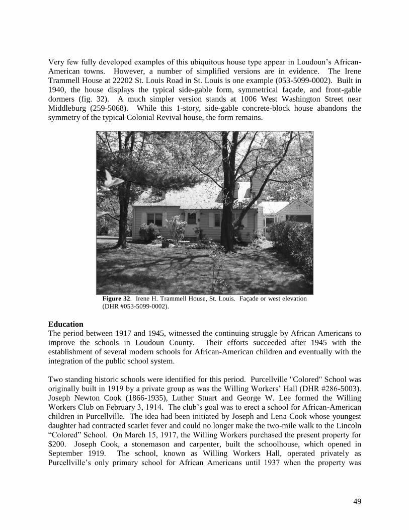
49
Very few fully developed examples of this ubiquitous house type appear in Loudoun’s African-
American towns. However, a number of simplified versions are in evidence. The Irene
Trammell House at 22202 St. Louis Road in St. Louis is one example (053-5099-0002). Built in
1940, the house displays the typical side-gable form, symmetrical façade, and front-gable
dormers (fig. 32). A much simpler version stands at 1006 West Washington Street near
Middleburg (259-5068). While this 1-story, side-gable concrete-block house abandons the
symmetry of the typical Colonial Revival house, the form remains.
Figure 32. Irene H. Trammell House, St. Louis. Façade or west elevation
(DHR #053-5099-0002).
Education
The period between 1917 and 1945, witnessed the continuing struggle by African Americans to
improve the schools in Loudoun County. Their efforts succeeded after 1945 with the
establishment of several modern schools for African-American children and eventually with the
integration of the public school system.
Two standing historic schools were identified for this period. Purcellville "Colored" School was
originally built in 1919 by a private group as was the Willing Workers’ Hall (DHR #286-5003).
Joseph Newton Cook (1866-1935), Luther Stuart and George W. Lee formed the Willing
Workers Club on February 3, 1914. The club’s goal was to erect a school for African-American
children in Purcellville. The idea had been initiated by Joseph and Lena Cook whose youngest
daughter had contracted scarlet fever and could no longer make the two-mile walk to the Lincoln
―Colored‖ School. On March 15, 1917, the Willing Workers purchased the present property for
$200. Joseph Cook, a stonemason and carpenter, built the schoolhouse, which opened in
September 1919. The school, known as Willing Workers Hall, operated privately as
Purcellville’s only primary school for African Americans until 1937 when the property was

50
deeded to the school board and it became known as the Purcellville ―Colored‖ School (fig. 33).
Between 1919 and 1947, the grades one through six were taught to hundreds of students.
Figure 33. Willing Workers Hall/Purcellville ―Colored‖ School,
Purcellville. East elevation (DHR #286-5003).
Built in 1921, the Willisville School (DHR #053-5116-0014) replaced an 1868 one-room
schoolhouse that also served as a church. The original schoolhouse, possibly sponsored by a
Northern Quaker group, burned in 1917. In 1921, after the land was deeded to the Mercer
District School Board, a new school was built. In 1934, the building was enlarged by a rear
classroom addition.

51
Recreation/Arts
Figure 34. Middleburg Baseball Team, ―Bush League‖ at Hall’s
Park (DHR #053-5155) ca. 1948-1950. Photo courtesy of Lewis &
Geraldine (Smith) Haley.
Located just north of the African-American hamlet of Macsville, Hall’s Park is associated with
the Hall family, a prominent African-American family in Loudoun County. In the early to mid-
20th century, the field that fronts the former Hall residence hosted many recreational activities
for African Americans. Horse races, baseball games, and festivals were held there. Middleburg’s
black baseball team was among the sports teams that played at Hall’s Park in the mid-20th
century (fig. 34). The park consists of an open field that fronts the Hall homestead at 23171
Carters Farm Lane (DHR #053-5155).
Religion
Three churches associated with the World War I to World War II Period were documented
during the survey. All but one of these were replacements for earlier church buildings.
Bluemont’s First Baptist Church stands today in the community of Murphy’s Corner, but was
originally erected on the eastern slope of the Blue Ridge southwest of the village of Bluemont
(DHR #053-5141-0007). Founded in 1888, the congregation originally worshiped in the
African-American schoolhouse that once stood on the slope of the mountain southwest of
Bluemont. In 1920, the congregation erected this building on the mountain. Because of the
declining population on the mountain and its difficult access, in 1949, the church building was
moved to its current location. Siblings Jim and Sarah Henderson donated the lot in Murphy’s
Corner.

52
Figure 35. Willisville Chapel, façade or south
elevation (DHR #053-1043).
A multi-denominational church was organized in Willisville in 1868; by 1884, the congregation
had affiliated with the Methodist Church (DHR #053-1043). George Evans purchased the
original land and building at another site for $40.00 from the late Lawyer Carter to be used as a
church and public school. In 1917, the original school and church was destroyed by fire. In
1924, Mary D. Neville, a white landowner living nearby, proposed to finance the building of a
new Willisville church if residents were able to collect the first $1,000 dollars necessary for
construction (fig. 35). Church trustees Frank Henderson, Moses Peterson, William Gaskins,
Dudley Gaskins and Daniel Hampton led a successful fundraising effort. According to local
residents, Neville drew the design of the stone church, modeling the building in a French country
style. Builder John Allison constructed the woodwork for the building and Albert Hall and
James Jackson completed the stone masonry.
Following a 1927 fire, the Hamilton congregation of Mount Zion Methodist Episcopal Church
(DHR #053-5197) also had to replace their original chapel. The town’s African-American
Methodist Episcopal congregation erected the first Mount Zion church in August 1881 on a half-
acre of land purchased by trustees Lafayette Mann, George Lee, Alfred Grisby, Lewis Hill and
Charles Taylor. The present 1928 frame building at 250 West Virginia Avenue replaced the
original frame structure. The existing building is a good, intact example of an early 20th-
century African-American church.

53
The New Dominion (1946-Present)
Domestic
Residential architecture after World War II increasingly reflected the influences of mass
production in the marketplace. In addition, a population boom along with housing subsidies for
veterans triggered the construction of large numbers of houses in and around large cities. The
growth of the suburbs slowly spread outward, but didn’t affect Eastern Loudoun County until the
late 1950s and early 1960s with the development of large-scale planned developments such as
Sterling.
In Loudoun’s African-American communities, only a few new residences were erected between
1946 and 1962. These buildings generally continue the trends seen in the World War I to World
War II Period. Cape Cod forms continued to be built, such as the stone-clad example at 34007
Welbourne Road in Willisville (1956, DHR #053-5116-0007), and the deteriorated frame
example at 24108 New Mountain Road (DHR #053-0605-0012) in Bowmantown (fig. 36).
Figure 36. House, 34007 Welbourne Road, Willisville. Façade or north
elevation (DHR #053-5116-0007).
The Ranch House form also began to appear as can be seen at the modified St. Louis residence at
35327 Snake Hill Road that was built in 1955 (DHR #053-5099-0007). Other, more traditional
forms persisted like the two-story, side-gable, concrete-block house that stands at 24134 Stewart
Town Lane in Stewartown (1954, DHR #053-5169).
Education
In the early 1940s, African-American advocates for better public education for blacks finally
succeeded in obtaining improved facilities in parts of Loudoun County. The first major victory
came in 1941 with the construction of Leesburg’s Douglass High School, the first high school for

54
African Americans in Loudoun County. The Carver School in Purcellville and the Banneker
School in St. Louis followed in 1946 and 1948 respectively.
The Colonial Revival-style George Washington Carver Elementary School (DHR #053-5199)
was erected south of the Purcellville town limits in 1946. The school operated until 1968 and is
now used for school equipment storage. Plans are underway to rehabilitate the former school as
a senior center.
Figure 37. Banneker School, St. Louis. Façade or north elevation (DHR
#053-0605-0004).
The 1948 Banneker School (DHR #053-5099-0010) is the only example of Modern Movement
architecture documented during the survey (fig. 37). The large brick school originally served
children from nearby Middleburg, Marble Quarry, and St. Louis. Still in operation today, the
school was named after Benjamin Banneker a noted 18th
century, African-American scientist.
Religion
Grace Annex Church (DHR #286-5001-0230) replaced the original 19th
century Grace Methodist
Episcopal Church in Lincoln that closed in 1942 because of dwindling membership. The
congregation moved to Purcellville where more members and potential members lived. The new
brick church was completed in 1957 and continues to serve the congregation today (fig. 38).

55
Figure 38. Grace Annex Methodist Episcopal Church, Purcellville.
Looking west (DHR #286-5001-0230).
First Baptist Church of Watson was formally organized on November 29, 1896 under the
leadership of Reverend Douglas D. Fisher and Reverend Bush W. Murray. The first church
building was erected on land donated by one of the founding members, Samuel Thornton. The
building burned in 1955 and was replaced by the present one-story, concrete block structure in
1957 (DHR #053-5087-0009).

56
VI. SURVEY FINDINGS
History Matters surveyed 213 properties that relate to the history of African Americans in
Loudoun County, Virginia. Of the surveyed properties, 203 were surveyed at the reconnaissance
level (exterior documentation) and ten were intensively documented (exterior and interior). (See
Appendix A for indices of survey properties.) Resources documented date from the late 18th
through the mid-20th
centuries with building types that included single- and multi-family
dwellings, schools, commercial buildings, religious buildings, and cemeteries. By far, the most
common building type was the single family dwelling, though 24 churches and ten schools were
also surveyed. Approximately 90 percent of the surveyed properties are located within the 30
historically African-American towns, villages, hamlets and neighborhoods that the project’s
cosponsor, the Black History Committee of the Friends of the Thomas Balch Library, identified
during their 2001 African American Community mapping project. The survey focused on
documenting the standing historic resources associated with those communities. The majority of
the communities were founded by African Americans in the three decades that followed the end
of the American Civil War. Former slaves who purchased land from white landowners
established many of the villages. For many of the early owners, this was their first land
purchase.
Seven of the 30 communities that were surveyed were selected by the client for additional
research and for the preparation of Preliminary Information Forms (PIFs) that can be submitted
to the Virginia Department of Historic Resources (DHR) to determine if these seven
communities are eligible for listing as historic districts on the National Register of Historic
Places. These seven communities are Bowmantown, Brownsville/Swampoodle, Howardsville,
Willisville, Watson, and Murphy’s Corner. Of the seven selected communities, historic research
indicates that Watson, was historically a mixed-race community and that many of the historically
African-American buildings have been lost. One section of the rural village may once have
housed a separate African-American community, but most of the historic resources associated
with it no longer exist.
These seven villages reveal that Loudoun’s African-American communities shared similar
historical development patterns and common architectural expressions. The communities were
established on typically small lots (under 10 acres) that generally were located on land that was
poor for farming. The early residents tended to work in service jobs and participate in small-
scale farming or gardening to feed their immediate families.38
Each community originally
included only a handful of single-family residences. Early in their development, community
residents organized to form religious congregations and build churches that also frequently
served as schoolhouses. When separate public schools were built, they were commonly erected
on land purchased or donated by community members. Residents, not the local school trustees,
often paid to construct the schools. Because of chronic underfunding of African-American
38
Throughout the county, there were undoubtedly many African-American farmers with larger properties that they
either owned or farmed as tenants. Few of these were identified in the survey since the focus was on the core
communities that developed following the Civil War.

57
education throughout Virginia, this was often the only way that African Americans could obtain
public school buildings for their children.
The architecture seen in the 30 African-American communities reveals information about the
ambitions of their residents. Often the most elaborate building details were reserved for the
community church or school, while individual houses were typically of modest size and plain
decoration. One building trend seen throughout these communities is the use of a true one-and-
a-half story building form for many dwellings. This side-gable form incorporates extended eaves
where half-size frieze windows are placed. The higher eaves and attic-story windows allow for
expanded living space in the attic story and additional light. Visually, this form looks larger than
a standard one-story-plus-attic building, but smaller than a true two-story structure. Speculation
suggests that its early use in Loudoun’s African-American communities may reflect both the
owners’ limited means and their desire to break from the antebellum building types where many
African Americans were enslaved.
In addition to surveying these specific African-American communities, the survey project also
documented historically African-American neighborhoods that are encompassed within or
adjacent to the county’s larger towns of Round Hill, Purcellville, Lovettsville, Hillsboro,
Middleburg, Hamilton, and Bluemont. These often racially segregated neighborhoods represent
important historical themes in the African-American experience in Loudoun County. They
illustrate how African Americans settled in segregated enclaves both because of state-supported
racial discrimination and for the mutual support.39
Using historic maps and information provided by local informants, History Matters identified
approximately 50 previously surveyed county and town properties that contain architectural
resources associated with the history of African Americans in Loudoun County. These resources
range from well-known historic sites such as Oatlands, Belmont, Lanesville and the Arcola Slave
Quarter to lesser known individual properties and neighborhoods in Loudoun’s towns and rural
areas. These better-known sites were not re-documented, but they provide an important resource
for interpreting African-American heritage in Loudoun County and have the added benefit of
being publicly owned or otherwise open to the public.40
The latter neighborhoods were
selectively surveyed and are important areas whose history should be further documented with
archival research, the collection of physical artifacts, and oral history. These African-American
neighborhoods should be incorporated into existing and potential historic districts and their
unique history and contributions to each town acknowledged in local histories. (See Appendix B
for brief descriptions of the histories of these neighborhoods.)
Local residents also helped to identify numerous previously undocumented historic sites.
Because of contract limitations, not all of the identified sites could be surveyed. Therefore, we
have collected basic location and historic information on approximately 40 potential African-
American historic sites that recommend for future research and documentation. (See Appendix
E.)
39
One common historical trend seen in several of Loudoun County’s larger towns was that the African American
neighborhoods were excluded from the town boundaries when the towns were incorporated. 40
Previously surveyed historic sites were not re-documented for this survey.

58
VII. RECOMMENDATIONS
Recommendations for Future Research
Current research by local and national scholars has furthered ongoing efforts, such as the one
represented by this survey report, to link important events, themes, and people in Loudoun
County’s history with the actual places with which they are associated. Several important areas
of inquiry remain to be researched. Areas that would benefit from combining physical site
survey with archival research include:
ante-bellum historic sites that focus on how free and enslaved African Americans lived;
Civil War and Reconstruction-era sites and themes;
large-scale agricultural properties that illustrate patterns of land ownership and
agricultural pursuits among Loudoun’s African-American population in the 19th
and 20th
centuries;
sites associated with the struggle of African Americans to establish and improve local
educational institutions, and
sites associated with the 20th
-century civil rights movement in Loudoun County.
During the course of the survey, several potential historic resources that are associated with
Loudoun’s African-American heritage were identified, but, due to scope of work constraints for
the field survey, were not surveyed. Appendix E lists 41 of these sites and provides location and
some historical background information when available.
In addition, there are many historic resources in Loudoun County that are either well known or
well documented that have the potential to help tell the story of African Americans in the
County. Appendix F contains a list of a sampling of previously surveyed sites that hold
significance for African-American history in Loudoun County. Some, such as Oatlands and
Claude Moore Park, though well known, have not been thoroughly examined in the context of
African-American history. Also, several neighborhoods within Loudoun County’s larger towns
that have been survey may need to be reexamined to include historic context about their African-
American residents.41
Undoubtedly, there are many more small settlements and rural properties
associated with African-American history throughout the county.
Further research using oral histories, local informants, land, tax, and census records could aid
efforts to uncover these sites. This research is necessary to understand the complete historical
context of Loudoun’s African-American historic sites and to provide data that allows citizens
and local officials to make informed decisions about how to treat historic sites when change is
proposed.
41
Where known, these previously surveyed areas have been roughly delineated in the brief community histories that
appear in Appendix B of this document.
59
Threats and Protection for Loudoun County‟s African-American Historic Resources
Because it is impossible to visually identify a historic site that relates to an important event,
person or historic theme, many of Loudoun County’s important historic resources are threatened
by development or neglect. This is especially the case for the county’s African-American sites,
which tend to be modest in appearance and display distinctive, non-normative architecture and
layouts. Thus, they are not clearly recognizable by the general public or by local officials.42
This project included the preparation of individual PIFs for seven African-American villages and
hamlets: Bowmantown, Brownsville/Swampoodle, Howardsville, Murphy’s Corner, St. Louis,
Watson, and Willisville. The PIFs are state forms that provide historical and descriptive
information to officials at the DHR that enables them to determine if a historic site or district is
potentially eligible for listing on the National Register of Historic Places and the Virginia
Landmarks Register.
National Register of Historic Places The National Register of Historic Places is the official federal list of historic districts, sites,
buildings, structures, and objects that are significant in American history, architecture,
archeology, engineering, and culture. The list is administered by the National Park Service
(NPS) with the assistance of the State Historic Preservation Office (SHPO) in each state. In
Virginia, DHR serves as Virginia’s SHPO.
Virginia Landmarks Register The Virginia Landmarks Register is the state’s official list of properties important to Virginia’s
history. The same criteria are used to evaluate resources for inclusion in the Virginia Landmarks
Register as are used for the National Register. Periodically, the department publishes an updated
edition of The Virginia Landmarks Register, a book that contains photographs and information
about the properties listed as Virginia landmarks. The list is administered by the State Historic
Preservation Office (SHPO).
Benefits of Listing on the Virginia Landmarks and National Registers
Rehabilitation tax credits are dollar-for-dollar reductions in income tax liability for taxpayers
who rehabilitate historic buildings. Credits are available from both the federal government and
Virginia. The amount of the credit is based on total rehabilitation costs. The federal credit
equals 20% of the eligible rehabilitation expenses and the Virginia credit equals 25% of the
eligible rehabilitation expenses. In some cases, taxpayers can qualify under both programs,
allowing them to claim credits of 45% of their eligible rehabilitation expenses.
Individual sites and historic districts that are included in the National Register of Historic Places
are recognized as having historic significance in local, state, or national history. National
Register listing also confers a level of protection to historic sites by requiring that all federal and
42 On the eastern end of the County, several of Loudoun’s rural African-American villages have been lost to the
pressures of residential and commercial development. In the 1960s, the village of Willard was razed to construct
Dulles International Airport. Near Sterling, the Nokesville community has been overwhelmed by residential and
commercial development. In the southeastern corner of the county, Conklin has almost disappeared.
60
state agencies consider the impact of their planning and construction activities on any property
that is listed on or that is eligible for listing on the National Register of Historic Places.
Potential listings on the Virginia Landmarks and National Registers
The seven PIF villages were pre-selected by Loudoun County and DHR officials before the
survey research began. Another hamlet that was surveyed may be eligible for listing on the
Virginia Landmark and National Registers. Known informally as Short Hill, the hamlet sits just
south of the town boundary of Hillsboro in the western section of Loudoun County. Settled
before the Civil War by free persons of color, by the turn of the 20th
century, the community
included several residences, a school for African Americans, and a Methodist church. (DHR#s
053-5204 – 053-5207).
As individual resources, many of the surveyed African-American architectural resources would
not meet the qualifying standards for National Register listing. However, a few sites should be
investigated further for their historical significance to determine if any are eligible. These
include the Chauncey DePew Brown House (DHR# 053-0588) where well-known musician and
bandleader Chauncey Brown was reputedly born and raised. Also, the boyhood home of
William ―Billy‖ Pierce (DHR# 286-5001-0107), a prominent 20th
-century dance instructor,
choreographer, and journalist who practiced in New York City may be eligible for individual
nomination. Another historically and architecturally significant historic site that may be eligible
for listing is the intact stone slave quarter near Arcola (053-0984) that was once associated with
the James Lewis farm.
An alternative to listing individual properties and historic districts is to prepare a Multiple
Property Listing (MPL), an umbrella document that identifies the property types and historical
themes that are associated with a particular group of historic resources that may warrant historic
designation. MPLs could be prepared for groupings such as ―African-American Historic
Resources in Loudoun County, Virginia, circa 1780 – 1955,‖ or for ―Nineteenth-Century
African-American Villages in Loudoun County, Virginia.‖ Another MPL study could be
―Underground Railroad & Sites Associated with the Abolition Movement in Loudoun County,
Virginia.‖ The advantage of MPLs is that they make the process of nominating individual sites
and districts simpler, and they provide invaluable historical background on pertinent topics that
can be used for local educational projects.
Finally, local, state-wide, or National Register listings of larger mixed-race historic districts in
Loudoun County such as Lovettsville, Round Hill, and Purcellville must take care to encompass
their historically African-American neighborhoods and sites which were often segregated or
located along the margins or even outside the original town boundaries. These racially
segregated neighborhoods are identified in the brief histories of these towns that are included in
Appendix B of this report.

61
Educational Activities and Heritage Tourism Development
The rich diversity of Loudoun County’s history provides great opportunities for historical
education and heritage tourism development. The county’s significant collection of African-
American heritage resources is one important segment of local cultural resources. Programs
such as those developed over the past several years by the Loudoun Museum, the Black History
Committee of the Friends of the Thomas Balch Library, and the Waterford Foundation have
greatly expanded knowledge of African-American history in Loudoun and have provided
numerous opportunities to draw heritage tourists and to work with local citizens. Activities have
included several topical exhibits, walking tours, guidebooks, brochures, conferences, and
lectures. These are all excellent means with which to promote knowledge and to collect data that
is important to understanding and interpreting history.
One future project that could help bring together all of the collected information and present it to
the public would be to develop a countywide African-American Heritage Trail. Such a project
could incorporate signage, written booklets or brochures, audio-visual, and web media to
promote a broader understanding of Loudoun County’s history. The County and private groups
could link their educational and heritage tourism efforts with regional and national initiatives
such as the National Park Service’s Network to Freedom program and the Virginia Foundation
for the Humanities African American Heritage in Virginia project. Other resources that could
provide support, money, or expertise for developing new programs are the National Trust for
Historic Preservation’s Main Street Center and the programs of the National Endowment for the
Humanities.

62
VIII. BIBLIOGRAPHY
Ayers, Edward L. The Promise of the New South: Life after Reconstruction. New York, NY:
Oxford University Press, 1992.
Barnard, Hollinger F., editor. Outside the Magic Circle: The Autobiography of Virginia Foster
Durr. New York City: Simon & Schuster, Inc, 1987.
Bates, Steve. ―He’s Searching for County’s Black History,‖ The Washington Post, 26 April
1990.
Bell, Derrick. And We Are Not Saved: The Elusive Quest for Racial Justice. New York: Basic
Books, 1987.
Benning, Victoria. ―A Shrinking Future for a Place in History: Loudoun Hamlet Nears Last
Chapter.‖ The Washington Post. 15 December 1996.
Berlin, Ira. Many Thousands Gone: The First Two Centuries of Slavery in North America.
Cambridge, MA: The Belknap Press of Harvard University Press, 1998.
Carlton, Eileen M. ―Howardsville.‖ Loudoun Times-Mirror. 10 July 1996.
Cultural Resources, Inc. Phase I Architectural and Archaeological Investigation of the Settle-
Dean Farmstead South Riding Development. Loudoun County, Virginia. July 2001.
______. Phase II Archaeological Evaluation of the Settle-Dean Farmstead Site. Loudoun
County, Virginia. September 2001.
Daniel, Pete. Breaking the Land: The Transformation of Cotton, Tobacco, and Rice Cultures
Since 1880. Chicago: The University of Illinois Press, 1985.
Deck, Patrick A. and Henry Heaton, ―An Economic and Social Survey of Loudoun County.‖ The
University of Virginia Record Extension Series. Charlottesville: 1926.
Devine, John, Wilbur C. Hall, Marshall Andres and Penelope M. Osburn. Loudoun County and
the Civil War: A History and Guide edited by Fitzhugh Turner. Westminster, VA:
Willow Bend Books, 1998.
Echtenkamp, Jon. ―Stones of Solace: Research May Reveal History of a Slave Family.‖ Loudoun
Times-Mirror. November 4, 1998.
The Essence of a People: Portraits of African Americans Who Made a Difference in Loudoun
County, Virginia. Leesburg, VA: Black History Committee of The Friends of the
Thomas Balch Library, 2001.

63
Fennell, Christopher, Log House Architecture in the Eighteenth-Century Virginia Piedmont,
Available online at
http://etext.lib.virginia.edu/users/fennell/highland/harper/demoryarch.html.
Fishback, Mary and Thomas Balch Library Commission. Images of America: Loudoun County:
250 Years of Towns and Villages. Charleston, SC: Arcadia, 1999.
Foner, Eric. Reconstruction: America‟s Unfinished Revolution 1863 – 1877. New York, NY:
Harper & Row, Publishers, 1988.
Franklin, John Hope and Alfred A. Moss, Jr. From Slavery to Freedom: A History of African
Americans. Eight edition. New York: Alfred A. Knopf, 2000.
Genovese, Eugene D. Roll, Jordan, Roll: The World the Slaves Made. New York, NY: Vintage
Books, 1976.
Guild, June Purcell. Black Laws of Virginia: A Summary of the Legislative Acts of Virginia
Concerning Negroes from Earliest Times to the Present. Originally published in 1936 by
Whittet & Shepperson; (Fourth Printing) Lovettsville, VA: Willow Bend Books, 1995.
Hamilton, Kendra, editor. The Essence of a People II: African Americans Who Made Their
World Anew in Loudoun County, Virginia and Beyond. Leesburg, VA: The Black
History Committee of the Friends of Thomas Balch Library, 2002.
Hardesty, H. H. & Company. Hardesty‟s Historical and Geographical Encyclopedia. Richmond,
VA: H.H. Hardesty & Company, 1884.
Harrison, Fairfax. Landmarks of Old Prince William: A Study of Origins in Northern Virginia in
Two Volumes. Second reprint edition. Originally published in 1927 by the Old Dominion
Press. Berryville, VA: Chesapeake Book Company, 1964.
Harwood, Herbert H. Rails to the Blue Ridge: The Washington and Old Dominion Railroad,
1847-1963. Falls Church, VA: The Pioneer American Society, 1969.
Head, James W. History and Comprehensive Description of Loudoun County Virginia. Loudoun
County, VA: James W. Head, 1908.
Hiatt, Marty. ―Jennie Dean Research Report,‖ 27 December 1998 and 22 January 1999.
Hill, Thomas L. ―They Were Here: Oral History Project of Charles Lewis Slave Descendants,
Hutchinson’s Farm, Arcola, Virginia (Formerly Gumsprings).‖ Brochure, n.d..
Hofstra, Warren R., ed. George Washington and the Virginia Backcountry. Madison: Madison
House Publishers Inc., 1998.

64
______. and Robert D. Mitchell. ―How Do Settlements Evolve? The Virginia Backcountry
During the Eighteenth Century,‖ Journal of Historical Geography. April 1995, v. 21, n.
2, p. 123.
Hopkins, Margaret Lail and Nancy Hopkins Phillips. The Anglican Parishes of Loudoun County,
Virginia: Truro, Cameron and Shelburne 1736-1805. Lovettsville, VA: Willow Books,
1997.
Issacs, Rhys. The Transformation of Virginia, 1740-1790. Chapel Hill: University of North
Carolina Press, date; The Early American Institute of History and Culture, Williamsburg,
VA, 1982.
James, Geraldine P. Purcellville: A Brief History of the Town, Schools, Library, etc. Unpublished
manuscript, June 1959.
Janney, Asa Moore. ―A History of the Society of Friends in Loudoun,‖ The Bulletin of the
Historical Society of Loudoun County, Virginia, 1957-1976. Leesburg, VA: Goose Creek
Productions, 1997.
Joyner, Brian D. African Reflections on the American Landscape: Identifying and Interpreting
Africanisms. Washington: Government Printing Office, 2003.
Kelly, Sheila Pinkney. ―A History of the Carver School Property, Purcellville’s First African
American School House, Its Builder, and His Wife’s Generosity to the Community.‖
October 4, 2001.
“Let Our Rejoicing Rise”: Emancipation Day in Loudoun County. Mid-County Printing:
Leesburg, VA, n.d.
Lenhart, Jennifer. ―History by Word of Mouth: Project to Document Black Communities.‖
Washington Post, Loudoun Extra, 9 November 2000.
Lewis, Stephen Johnson. Undaunted Faith…The Life Story of Jennie Dean: Missionary,
Teacher, Crusader, Builder. Founder of the Manassas Industrial School. [n.p.].
Link, William A. Roots of Secession: Slavery and Politics in Antebellum Virginia. Chapel Hill:
University of North Carolina Press, 2003.
Loth, Calder. Virginia Landmarks of Black History: Sites on the Virginia Landmarks Register
and the National Register of Historic Places. University Press of Virginia:
Charlottesville, VA, 1995.
Loudoun County's African American Communities, Exhibit Text, 2001. [Exhibit at the Thomas
Balch Library, Leesburg, VA.]

65
Loudoun County Civil War Centennial Commission and the Loudoun County Board of
Supervisors. Loudoun County and the Civil War: A History and a Guide. Reissued.
Leesburg, VA: Willow Bend Books, 1998.
Loudoun County, Virginia Cemeteries: A Preliminary Index. Lovettsville, VA: Willow Bend
Books, 1996.
Lynn, Martha and H.H. Douglas. ―Occoquan, Prince William County, Virginia,‖ Echoes of
History. January 1971.
Martin, Joseph. A New and Comprehensive Gazetteer of Virginia, and the District of Columbia.
Charlottesville: Mosely & Tompkins, 1836.
McDonald, Jean. ―County History Rests Here.‖ Loudoun Times-Mirror, 19 October 1978, sec.
B-2.
McKenney, Maura. ―An Oral History of Life in Bowman Town Aldie, VA: As Told by Mr.
Norman Stewart, age 89.‖ Unpublished oral history paper, November 7, 2001.
McKenney, Maura and Dodi Turney. Bull Run School, The „Lost‟ School of Bowman Town,‖
Unpublished manuscript, Fall 2001.
McPherson, James M. Battle Cry of Freedom: The Civil War Era. Oxford University Press,
1988; New York: Ballantine Books, 1989.
Miller, Peter. ―Remembering the Emancipation Association,‖ Loudoun Times-Mirror, 30 June
1977.
Mitchell, Robert D. Commercialism and Frontier: Perspectives on the Early Shenandoah Valley.
Charlottesville: University Press of Virginia, 1977.
______. ―The Settlement Fabric of the Shenandoah Valley, 1790-1860: Pattern, Process, and
Structure,‖ After the Backcountry: Rural Life in the Great Valley of Virginia, 1800-1900
edited by Kenneth E. Koons and Warren R. Hofstra. Knoxville: University of Tennessee
Press, 2000.
Mooney, Barbara Burlison. ―The Comfortable Tasty Framed Cottage: An African American
Architectural Iconography,‖ Journal of the Society of Architectural Historians, Vol. 61,
No. 1. March 2002.
Netherton, Nan and Donald Sweig, Janice Artemel, Particia Hickin, and Patrick Reed. Fairfax
County, Virginia: A History. Fairfax, VA: Fairfax County Board of Supervisors, 1978.
Nichols, Joseph V. Legends of Loudoun Valley. Lovettsville, VA: Willow Bend Books, 1996.
Norton, Donna. Recollections of Hamilton. 2003. p. 95-101.

66
Phillips, John T., II. The Historians Guide to Loudoun County, Virginia, Volume One: Colonial
Laws of Virginia and County Court Orders, 1757-1766. Leesburg, VA: Goose Creek
Publications, 1996.
______. The Guide to Loudoun County: A Survey of the Architecture and History of a Virginia
County. Leesburg, VA: Potomac Press, 1975.
Poland, Charles P., Jr. From Frontier to Suburbia. Marceline, MO: Walsworth Publishing
Company, 1976.
Rowberg, Andrew A. and Marie C. ―The Post Offices of Loudoun County,‖ The Bulletin of the
Historical Society of Loudoun County, Virginia, 1957-1976. Leesburg, VA: Goose Creek
Productions, 1997.
Sadowski, Cheryl. ―Along Short Hill, a Matter of Preserving Historic Past,‖ Loudoun Times-
Mirror. 26 November 2003.
Saffer, Wynne C. Loudoun Votes 1867-1966: A Civil War Legacy. Westminster, MD: Willow
Books, 2003.
______. ―Loudoun County, Virginia: 1860 Land Tax Maps, Thomas M. Wrenn’s District.‖
Unpublished paper, 2002.
Salmon, Emily J. and Campbell, Edward D.C. Jr., eds. The Hornbook of Virginia History: A
Ready-Reference Guide to the Old Dominion's People, Places, and Past. Richmond, VA:
The Library of Virginia, 1994.
Salvatore, Susan et al. Racial Desegregation in Public Education in the United States.
Washington: Government Printing Office, August 2000.
Sanders, H. R. and Eliza D. Lunceford. Loudoun County Geography Supplement: “Know Your
Own County”. Loudoun County School Board. Charlottesville: University of Virginia,
1925.
Scheel, Eugene M. ―The Best Bird Hunting Around.‖ Loudoun Times-Mirror, n.d.
______. ―Bowmantown, Loudoun’s First Black Settlement,‖ Loudoun Times-Mirror, Section B,
10 June 1976.
. ―Brown’s Corner: A 4-House Huddle.‖ Loudoun Times-Mirror, 22 July 1978.
. ―Double Names, Long History.‖ Loudoun Times-Mirror, n.d.
. ―Dover was Named for an English Village; Old Mill gave Stones to Middleburg Bank.‖
Loudoun Times-Mirror, 4 November 1976.

67
. ―Downtown Britain, a German Settlement.‖ Loudoun Times-Mirror, 1976.
. ―Faithful Came to Valley for Sobering Words.‖ The Washington Post, Section V03, 6
August 2000.
. ―Father and Son Treated a Century of Ills.‖ Washington Post, Loudoun Extra, 25 March
2001.
. ―Gleedsville Named After Ex-Slave.‖ Loudoun Times-Mirror, 7 April 1977.
. The Guide to Loudoun County: A Survey of the Architecture and History of a Virginia
County. Leesburg, VA: Potomac Press, 1975.
. ―Hamilton Began with Corner Store.‖ Loudoun Times-Mirror, 19 May 1977.
. ―Heaton’s Crossroads—Once a Meeting Place for Political Talk.‖ Loudoun Times-
Mirror, Section B, 13 October 1977.
. ―Hillsboro – Gap in the Short Hills,‖ Loudoun Times-Mirror, 11 August 1977.
. ―A History of Purcellville,‖ Loudoun Times-Mirror, 21 June 1979.
. ―History of Sycolin Area Dates to 1700’s.‖ Loudoun Times-Mirror, n.d.
. ―Howardsville, a Black Community in Loudoun.‖ Loudoun Times-Mirror, 10 July 1996.
. ―Joseph Conklin Left Name to Area.‖ Loudoun Times-Mirror, 23 September 1976.
. ―Lanesville: Site of Historic Post Office.‖ Loudoun Times-Mirror, 4 May 1978.
. ―St. Louis’ Name.‖ Loudoun Times-Mirror, 16 October 1980.
. ―St. Louis Name Never Settled.‖ Loudoun Times-Mirror, 2 October 1980.
. ―St. Louis Dates to Late 1800s.‖ Loudoun Times-Mirror, 25 September 1980.
. ―Lovettsville Germans Fled Pennsylvania Squabble.‖ Loudoun Times-Mirror, 20 April
1978.
______. ―Marble Quarry Began with a Grist Mill.‖ Loudoun Times-Mirror, 21 July 1970.
. ―Powell’s Grove: Once Famous.‖ Loudoun Times-Mirror, 8 November 1979.
, ―Rock Hill is One of Four Names for Area,‖ Loudoun Times Mirror, 24 January 1980.
68
. ―Round Hill Dates to Early Records.‖ Loudoun Times-Mirror, 31 July 1980.
. ―Several Churches Served old Conklin.‖ Loudoun Times-Mirror, 28 August 1991.
. ―Stewartown Settled During the 1860’s.‖ Loudoun Times-Mirror, 12 March 1981.
. The Story of Purcellville, Loudoun County, Virginia. Purcellville, VA: First Virginia
Bank, First National Bank of Purcellville, 1977; 1983.
. ―A Straggle of Houses called Macsville.‖ Loudoun Times-Mirror, 13 July 1978.
. ―Three Voices from the Past, Remembered in Words and Deed.‖ Washington Post, 25
February 2001.
. ―Watson Community Gained Store, Post Office in 1888.‖ Loudoun Times Mirror, 27
May 1982.
. ―Willisville History Dates to Pre-Civil War Era,‖ Loudoun Times-Mirror, Section A-
14, 28 April 1983.
Scheweninger, Loren. Black Property Owners in the South: 1790-1915. Urbana: University of
Illinois Press, 1997.
Selby, John E. The Revolution in Virginia: 1775-1783. Williamsburg, VA: The Colonial
Williamsburg Foundation, 1998.
Silver, Jim. ―Developments Erase Slavery’s Historic Sites.‖ The Connection. January 31-
February 6, 2001.
Smith, J. Douglas. Managing White Supremacy: Race, Politics, and Citizenship in Jim Crow
Virginia. Chapel Hill: University of North Carolina, 2002.
Smith, Jean Herron. ―Snickersville: The Biography of a Village.‖ Miamisburg, Ohio:
Miamisburg News, 1970; Bluemont, VA: Robert W. Hoffman, 2000.
Souders, Bronwen C. and John M. Souders. A Rock in a Weary Land, a Shelter in a Time of
Storm: African-American Experience in Waterford, Virginia. Waterford, VA: The
Waterford Foundation, Inc., 2003.
Souders, Bronwen C. ―Notes on The Underground Railroad in Loudoun County.‖ Unpublished
Report. Waterford, Virginia, March 2000.
Stevenson, Brenda E. Life in Black and White: Family and Community in the Slave South. New
York: Oxford University Press, 1996.

69
Sweig, Donald M. Free Negroes in Northern Virginia: An Investigation of the Growth and Status
of Free Negroes in the Counties of Alexandria, Fairfax, and Loudoun, 1770-1860.
Masters Thesis, History. Fairfax, Virginia: George Mason University, 1975.
Thompson, Elaine, E. Courage My Soul: Historic African American Churches and Mutual Aid
Societies. Leesburg, VA: Loudoun Museum, 2000.
Thunderbird Archaeology: Phase I Archaeology Survey of Sites 44LD0922, 44LD0923,
44LD0924, 44LD0925, 44LD0926. 2003.
Tyler-McGraw, Marie and Kira R. Badamo. Underground Railroad Resources in the United
States: Theme Study by. Washington: Government Printing Office, September 2000.
Weatherly, Yetive Rockefeller. Lovettsville: The German Settlement. Lovettsville, VA: The
Lovettsville Bicentennial Committee, 1976.
Wellman, Judith. ―The Underground Railroad and the National Register of Historic Places:
Historical Importance vs. Architectural Integrity,‖ The Public Historian, Vol. 24, No.1.
Winter 2002, 11-30.
Williams, Ames, W. Washington & Old Dominion Railroad, 1847-1968. Alexandria, VA:
Meridian Sun Press, 1984.
Williams, Harrison. Legends of Loudoun: An Account of the History and Homes of a Border
County of Virginia's Northern Neck. Richmond, VA: Garrett and Massie Inc., 1939.
Woodward, C. Vann. Origins of the New South 1877-1913. Louisiana State University Press,
1951; 1971; 1990.
Maps
1823
Boye, Herman. Map of the State of Virginia: Constructed in Conformity to Law, from the late
Surveys authorized by the Legislature, and other Original and Authentic Documents.
(Originally published in 1826; reprinted in part by the Fairfax County Board of
Supervisors 1981).
1853
Taylor, Yardley. Map of Loudoun County, Virginia from Actual Surveys by Yardley Taylor.
Philadelphia, PA: Thomas Reynolds & Robert Pearsall Smith, 1853.
1864
Brown, Samuel Howell. [Map of the lower Shenandoah Valley, Virginia.] Engineering Office,
2nd
Corps, Army of Northern Virginia, September 9, 1864.
1893

70
Department of Interior. U.S. Coast and Geodetic Survey. Harper‟s Ferry. Washington, DC:
1893.
1908
Department of Interior. U.S. Coast and Geodetic Survey. Antietam. Washington, DC: 1908.
1919
Skinner, Margot L. “Tri” Hunting Map.
1923
Emerick, Oscar L., Superintendent of Schools. Loudoun County, Virginia, 1923.
1925
United States Post Office Department. Division of Topography. Rural Delivery Routes:
Loudoun County, Virginia. Washington, DC: 1925, 1941.
1932
Commonwealth of Virginia. Department of Highway. Division of Surveys and Plans. Map of
Loudoun County Showing Primary and Secondary Highways. Richmond, VA: 1932.
1933
Sanborn Map Company, [Purcellville, Virginia], March 1933.
1937
United States Soil Conservation Service. Southeastern Region. Conservation Study: SCD-13
Northern Virginia District, Loudoun County. Washington, DC: April 30, 1937, May 1,
1937.
1938-1939
Department of Interior. U.S. Coast and Geodetic Survey. Berryville. Washington, DC: 1938-39.
1941
United States Post Office Department. Division of Topography. Rural Delivery Routes:
Loudoun County, Virginia. Washington, DC: 1925, 1941.
1944
United States Forest Service. U.S. Coast and Geodetic Survey and the U.S. Geological Survey.
Washington, DC: 1944.
1957
Commonwealth of Virginia. Virginia Department of Highways. Loudoun County, Virginia
Showing Primary and Secondary Highways, January 1, 1957.

71
1981
Stephenson, Richard W. The Cartography of Northern Virginia: Facsimile Reproductions of
Maps Dating From 1608-1915. Fairfax, Virginia: History and Archaeology Section
Office of Comprehensive Planning, Fairfax County, Virginia, 1981.
1983
Davis, George B., Leslie J. Perry, Joseph W. Kirkley, and Calvin D. Cowles. The Official
Military Atlas of the Civil War. New York: Gramercy Books, 1983.
2001
Loudoun County Office of Mapping. Historically African American Communities of Loudoun
County, Virginia. Map# 2001-015. Leesburg, VA: May 15, 2001.
2004
Loudoun County Parcel Assessment Database. [Online]-HTTP:
http://inter1.loudoun.gov/webpdbs/

72
APPENDIX A: Survey Indexes
Index to Surveyed Resources Sorted by DHR Identification Number
Index to Surveyed Resources Sorted by Loudoun County Parcel Identification Number (PIN)
Chronological List of Surveyed Resources
Historic Context Report of Surveyed Resources
Historic Period Report of Surveyed Resources

73
Index to Surveyed Resources Sorted by DHR Identification Number
DHR ID Number
Loudoun County Parcel
Identification Number (PIN)
Resource Name Street Address/
Location Town/Village/
Hamlet/Vicinity USGS
Quadrangle Map
053-0062-0001 655-49-2132 House 20857 Greengarden Road Howardsville Bluemont
053-0062-0002 655-38-0759 House 20999 Greengarden Road Howardsville Bluemont
053-0062-0003 655-38-3899 House 20929 Greengarden Rd. Howardsville Bluemont
053-0062-0004 655-38-5637 House 20965 Greengarden Road Howardsville Bluemont
053-0062-0005 655-38-5907 Reid, Gracie, House 21011 Greengarden Road Howardsville Bluemont
053-0062-0006 655-38-3732 House 20991 Greengarden Road Howardsville Bluemont
053-0174 421-10-6969 Mount Gilead Township School 38747 Hughesville Road Hughesville Lincoln
053-0205 455-36-2851 Grace M.E. Church West end of Brooks Lane Lincoln Lincoln
053-0322 221-29-6877 Mount Pleasant Baptist Church 41803 Bald Hill Road Lucketts Waterford
053-0464 421-10-6969 Hughesville Baptist Church 38747 Hughesville Road Hughesville Lincoln
053-0584 432-17-4722 Moore, Frank House 38446 John Mosby Highway Dover Middleburg
053-0587 503-40-9105 Smith Family House 37600 John Mosby Highway Macsville Middleburg
053-0588 503-35-4209 Brown, Chauncey DePew, House 37040 John Mosby Highway Brown's Corner Middleburg
053-0589 503-35-2245 Maryland Heights 23363 John Mosby Highway Brown's Corner Middleburg
053-0605-0001 363-45-5386 House 24035 New Mountain Road Bowmantown Middleburg
053-0605-0002 363-45-5386 House 24029 New Mountain Road Bowmantown Middleburg
053-0605-0003 362-15-7206 Former Bull Run School 24015 New Mountain Road Bowmantown Middleburg
053-0605-0004 362-15-9654 House 23965 New Mountain Road Bowmantown Middleburg
053-0605-0005 362-15-4130 House 23985 New Mountain Road Bowmantown Middleburg
053-0605-0006 363-46-1365 House 24054 New Mountain Road Bowmantown Middleburg
053-0605-0007 363-45-7925 House 24060 New Mountain Road Bowmantown Middleburg
053-0605-0008 363-36-9682 Bowman, Walter, House 24127 Bowmantown Road Bowmantown Middleburg
053-0605-0009 363-37-2784 House 24126 Bowmantown Road Bowmantown Middleburg
053-0605-0010 363-37-3980 Bowman, Jim & Frances, House 24146 Bowmantown Road Bowmantown Middleburg
053-0605-0011 363-36-1057 Corum's Store 39567 Moss Ridge Road Bowmantown Middleburg
053-0605-0012 363-35-7486 House 24108 New Mountain Road Bowmantown Middleburg
053-0697 369-20-6910 Antioch M.E. Church 1? N. Berlin Turnpike Lovettsville Harper's Ferry
053-0823 455-36-6782 Bell, Harold, House 37764 Brooks Lane Lincoln Lincoln
053-0825 455-36-6170 Lucas House 37758 Brooks Lane Lincoln Lincoln
053-0843 455-36-7114 Brent House 37766 Brooks Lane Lincoln Lincoln
053-0845 455-35-9263 Lincoln “Colored” School 37706 Cooksville Road Lincoln Lincoln
053-0899 192-16-2972 Union Church/ First Baptist Church 19976 Sycolin Road Sycolin Leesburg

Index to Surveyed Resources Sorted by DHR Identification Number
74
DHR ID Number
Loudoun County Parcel
Identification Number (PIN)
Resource Name Street Address/
Location Town/Village/
Hamlet/Vicinity USGS
Quadrangle Map
053-0909 518-39-6445 Asbury M.E. Church Ashbury Church Road - Rte 718 Hillsboro Purcellville
053-0932 500-30-6707 Berryman, Raymond & Mattie, House 37568 Berryman Road Berryman Lincoln
053-0984 162-17-2899 Stone Slave Quarters 24837 Evergreen Mills Road Arcola Arcola
053-0987 282-25-6592 Watson General Store 22597 Watson Road Watson Arcola
053-0988 321-29-0607 Hartke, Sandra, House 22336 James Monroe Highway Oatlands vicinity Arcola
053-0994 316-49-7927 Mt. Olive M.E. Church 20460 Gleedsville Road Gleedsville Leesburg
053-1023 399-30-8316 Mt. Pleasant Baptist Church No address-New Mountain Rd Bowmantown Middleburg
053-1024 399-30-3900 Napper Log House No address-Buchannon Gap Rd Stewartown Middleburg
053-1043 658-30-9380 Willisville Chapel 34008 Welbourne Road Willisville Bluemont
053-1049 596-25-9397 Mt. Zion Baptist Church 35286 Snake Hill Road St. Louis Bluemont
053-1060 633-36-6922 Scipio, Beatrice, House 18556 Foggy Bottom Road Murphy's Corner Bluemont
053-5086 465-26-3702 Second Marble Quarry School 22282 Sam Fred Road Berryman Lincoln
053-5087-0001 282-26-1094 House 22610 Watson Road Watson Arcola
053-5087-0002 282-46-0501 House 22503 Watson Road Watson Arcola
053-5087-0003 282-46-0501 Watson Hall 22529 Watson Road Watson Arcola
053-5087-0004 282-46-0501 House 22579 Watson Road Watson Arcola
053-5087-0005 282-25-6592 Church Family House 22603 Watson Road Watson Arcola
053-5087-0006 282-16-4189 House 40710 Red Hill Road Watson Arcola
053-5087-0007 282-17-5024 Thornton House 40837 Red Hill Road Watson Arcola
053-5087-0008 282-17-6376 House 40852 Red Hill Road Watson Arcola
053-5087-0009 282-18-5852 First Baptist Church, Watson 40931 Red Hill Road Watson Arcola
053-5087-0010 283-49-1796 House 40991 Red Hill Road Watson Arcola
053-5097 no tax id # House 25600 Elk Lick Road Conklin Arcola
053-5098 295-26-4513 House 40455 Quaterbranch Road Lovettsville Point of Rocks
053-5099-0001 621-20-2998 House 22209 McQuay Heights Lane St. Louis Bluemont
053-5099-0002 621-20-9187 Trammell, Irene H., House 22202 St. Louis Road St. Louis Bluemont
053-5099-0003 621-30-8030 House 22181 St. Louis Road St. Louis Bluemont
053-5099-0004 596-25-6595 Jackson, Mary Jane, House 35262 Snake Hill Road St. Louis Bluemont
053-5099-0005 596-46-8529 House 22032 St. Louis Road St. Louis Bluemont
053-5099-0006 596-37-3190 St. Louis School 35430 Hamlin School Lane St. Louis Bluemont
053-5099-0007 596-26-3085 Grant, M. Louise, House 35327 Snake Hill Road St. Louis Bluemont
053-5099-0008 596-26-1383 Strickland, Dwight, House 35307 Snake Hill Road St. Louis Bluemont
053-5099-0009 596-25-7434 Store 35285 Snake Hill Road St. Louis Bluemont
053-5099-0010 596-25-2318 Banneker School 35231 Snake Hill Road St. Louis Bluemont
053-5099-0011 621-20-7255 Madison House 22240 St. Louis Road St. Louis Bluemont

Index to Surveyed Resources Sorted by DHR Identification Number
75
DHR ID Number
Loudoun County Parcel
Identification Number (PIN)
Resource Name Street Address/
Location Town/Village/
Hamlet/Vicinity USGS
Quadrangle Map
053-5099-0012 621-20-4456 Mattingly, Don E., Jr., House 22241 St. Louis Road St. Louis Bluemont
053-5099-0013 621-20-4967 House 22249 St. Louis Road St. Louis Bluemont
053-5099-0014 621-29-8931 House 22256 Newlin Mill Road St. Louis Bluemont
053-5099-0015 621-29-9010 Smith, Willie & Grace Jackson House 22309 St. Louis Road St. Louis Bluemont
053-5099-0016 621-19-9193 Basil, Charles & Armeata, House 22317 St. Louis Road St. Louis Bluemont
053-5099-0017 597-46-5120 House 22326 St. Louis Road St. Louis Bluemont
053-5116-0001 658-40-5003 House 33911 Welbourne Road Willisville Bluemont
053-5116-0002 658-30-6465 Abandoned House, Welbourne Rd. Welbourne Rd. Willisville Bluemont
053-5116-0003 658-30-7260 House 33973 Welbourne Road Willisville Bluemont
053-5116-0004 658-30-8453 Abandoned House between 33995 & 34001 Welbourne Rd Willisville Bluemont
053-5116-0005 642-35-0533 House, West of 34001 Welbourne Road Willisville Bluemont
053-5116-0006 658-30-7707 House 34001 Welbourne Road Willisville Bluemont
053-5116-0007 642-35-0757 House 34007 Welbourne Road Willisville Bluemont
053-5116-0008 658-30-8643 House 34017 Welbourne Road Willisville Bluemont
053-5116-0009 642-35-4345 Willisville Store 34049 Welbourne Road Willisville Bluemont
053-5116-0010 642-35-3622 House 34055 Welbourne Road Willisville Bluemont
053-5116-0011 658-30-7485 House 33978 Welbourne Road Willisville Bluemont
053-5116-0012 658-30-5286 Gaskin, Rosalee, House 33974 Welbourne Road Willisville Bluemont
053-5116-0013 658-30-3593 House 33960 Welbourne Road Willisville Bluemont
053-5116-0014 658-30-3064 Willisville School (former) 33910 Willisville Road Willisville Bluemont
053-5116-0015 658-30-5629 House 33995 Welbourne Road Willisville Bluemont
053-5137 637-45-0287 Austin Grove M.E. Church 33999 Austin Grove Road Rock Hill Bluemont
053-5138 588-16-4980 Powell's Grove United Meth. Church 19100 Airmont Road Powell's Grove Bluemont
053-5139 635-49-4004 Walsh Farm Slave Quarter 19312 Walsh Farm Lane Paxson/Berkley Bluemont
053-5140 649-48-6721 Butcher's Hollow House 33691 Snickersville Turnpike (?) Butcher's Hollow Bluemont
053-5141-0001 633-46-8915 House 34056 Snickersville Turnpike Murphy's Corner Bluemont
053-5141-0002 633-47-2137 House 34062 Snickersville Turnpike Murphy's Corner Bluemont
053-5141-0003 633-37-1480 House 34090 Snickersville Turnpike Murphy's Corner Bluemont
053-5141-0004 633-36-9390 House 34058 Snickersville Turnpike Murphy's Corner Bluemont
053-5141-0005 633-36-6966 House 18526 Foggy Bottom Road Murphy's Corner Bluemont
053-5141-0006 633-36-7563 House 34069 Snickersville Turnpike Murphy's Corner Bluemont
053-5141-0007 633-36-8765 Bluemont First Baptist Church 34081 Snickersville Turnpike Murphy's Corner Bluemont
053-5141-0008 633-37-1431 House 34117 Snickersville Turnpike Murphy's Corner Bluemont
053-5149 503-35-2323 House 23375 Sam Fred Road Brown's Corner Middleburg
053-5150 503-35-2323 House 23381 John Mosby Highway Brown's Corner Middleburg

Index to Surveyed Resources Sorted by DHR Identification Number
76
DHR ID Number
Loudoun County Parcel
Identification Number (PIN)
Resource Name Street Address/
Location Town/Village/
Hamlet/Vicinity USGS
Quadrangle Map
053-5151 503-30-9576 Brown House 23320 Forsythia Lane Macsville Middleburg
053-5152 468-35-0282 Fisher House & Workshop 37603-37609 John Mosby Hwy Macsville Middleburg
053-5153 468-35-1275 House 37615 John Mosby Highway Macsville Middleburg
053-5154 468-45-3205 Fisher, David, House 37632 John Mosby Highway Macsville Middleburg
053-5155 467-26-0518 Hall's Park 23171 Carters Farm Lane Macsville Middleburg
053-5168 399-39-5123 House 39245 Buchannon Gap Road Stewartown Middleburg
053-5169 399-38-7871 House 24134 Stewart Town Lane Stewartown Middleburg
053-5170 399-38-4083 House 24151 Stewart Town Lane Stewartown Middleburg
053-5171 369-30-8440 Berry, Warty, House 21 Berlin Pike Lovettsville Harper's Ferry
053-5172 370-40-7837 Morgan, Molly, House 14 S. Loudoun Street Lovettsville Harper's Ferry
053-5173 370-40-9427 Lovettsville School 11 S. Locust Street Lovettsville Harper's Ferry
053-5174 370-40-3812 House 24 S. Loudoun Street Lovettsville Harper's Ferry
053-5175 442-16-4657 Mt. Sinai Free Baptist Cemetery Britain Rd. & Laramy Ln. Britain/Guinea Harper's Ferry
053-5176-0001 382-29-9993 House 39291 E. Colonial Highway Brownsville Purcellville
053-5176-0002 382-30-0115 Brownsville School 39306 E. Colonial Highway Brownsville Purcellville
053-5176-0003 382-20-0677 House 39335 E. Colonial Highway Brownsville Purcellville
053-5176-0004 382-20-4294 House 39345 E. Colonial Highway Brownsville Purcellville
053-5176-0005 382-20-2675 Second Mount Olive Baptist Church 17406 E. Colonial Highway Brownsville Purcellville
053-5176-0006 382-20-0578 House 17429 Brownsville Lane Brownsville Purcellville
053-5176-0007 382-20-0660 House 17445 Brownsville Lane Brownsville Purcellville
053-5176-0008 382-20-0737 House 17471 Brownsville Lane Brownsville Purcellville
053-5183 418-49-9302 Mt. Zion M. E. Church Parsonage 114 Maryland Street Hamilton Purcellville
053-5184 418-39-6983 Collins House 70 Laycock Street Hamilton Purcellville
053-5185 418-48-3133 Clark, Eugene, House 115 Ivandale Road Hamilton Purcellville
053-5186 418-48-3446 Harvey, Fannie, House 119 North Ivandale Road Hamilton Purcellville
053-5187 418-48-7445 Johnson, Charley, House 120 N. Ivandale Road Hamilton Purcellville
053-5188 418-48-7061 Clark, Howard Willard, House 124 Delaware Ave. Hamilton Purcellville
053-5189 418-49-5240 House 102 Delaware Avenue Hamilton Purcellville
053-5190 418-49-2212 House 258 Maryland Avenue Hamilton Purcellville
053-5191 418-49-5002 Store, west of 242 Maryland Ave. Hamilton Purcellville
053-5192 418-49-4506 Lucas, Mary Jane, House 242 Maryland Ave. Hamilton Purcellville
053-5193 418-49-6012 House 232 Maryland Ave. Hamilton Purcellville
053-5194 418-39-8199 House 118 Maryland Ave. Hamilton Purcellville
053-5195 418-30-1846 Fields, Mary Clark, House 102 W. Virginia Ave. Hamilton Purcellville
053-5196 418-30-0780 Gaskins, Clint, House 12 W. Virginia Ave. Hamilton Purcellville

Index to Surveyed Resources Sorted by DHR Identification Number
77
DHR ID Number
Loudoun County Parcel
Identification Number (PIN)
Resource Name Street Address/
Location Town/Village/
Hamlet/Vicinity USGS
Quadrangle Map
053-5197 418-38-9881 Mt. Zion M.E. Church 250 W. Virginia Ave. Hamilton Purcellville
053-5198 418-48-7800 Rowe, George, House 284 W. Virginia Ave. Hamilton Purcellville
053-5199 489-48-7172 Carver, George Washington, School 700 S. 15th Street Purcellville Purcellville
053-5200 489-48-4455 House 710 20th Street Purcellville Purcellville
053-5201 489-48-2667 House 730 S. 20th Street Purcellville Purcellville
053-5202 489-48-3845 House 750 20th Street Purcellville Purcellville
053-5203 489-48-3435 House 760 S. 20th Street Purcellville Purcellville
053-5204 518-39-2864 House 15411 Ashbury Church Road Short Hill Purcellville
053-5205 518-39-2864 House 15407 Ashbury Church Road Short Hill Purcellville
053-5206 518-39-6504 Hillsboro “Colored” School (former) 15425 Ashbury Church Road Short Hill Purcellville
053-5207 518-28-8780 House 15469 Ashbury Church Road Short Hill Purcellville
053-5208 024-45-2936 House 220 Oakgrove Road Oak Grove Herndon
053-5209 024-45-7241 House 102 Hall Road Oak Grove Herndon
053-5210 024-45-8615 House 105 Hall Road Oak Grove Herndon
053-5211 024-35-9991 House 112 Locust Lane Oak Grove Herndon
053-5212 024-46-1211 House 102 Locust Lane Oak Grove Herndon
053-5213 024-36-2699 House 104 Dominion Lane Oak Grove Herndon
053-5214 024-46-2325 Oak Grove Baptist Church & Cemetery 22870 Dominion Lane Oak Grove Herndon
053-5215 192-16-8342 House 20058 Sycolin Road Sycolin Leesburg
053-5216 192-16-3634 House 20028 Sycolin Road Sycolin Leesburg
053-5217 193-46-1044 House 20100 Sycolin Road Sycolin Leesburg
053-5218 315-10-7504 Gleedsville Cemetery Mt. Olive M.E. Church Gleedsville Leesburg
053-5219 316-39-6193 House 20492 Gleedsville Road Gleedsville Leesburg
053-5220 316-39-5585 House 20514 Gleedsville Road Gleedsville Leesburg
053-5222 029-48-9240 House 45805 Jona Drive Nokesville Sterling
053-5223 030-46-5708 Nokes House 45564 Thayer Road Nokesville Sterling
053-5224 020-20-1794 House 46531 Harry Byrd Highway Nokesville Sterling
053-5225 455-35-4275 Trammel, John, House 37646 Cooksville Road Lincoln Lincoln
053-5226 129-15-1581 House 25926 Elk Lick Road Conklin Arcola
053-5227 no tax id # House 25974 Elk Lick Road Conklin Arcola
053-5228 167-40-9076 House 26014 Elk Lick Road Conklin Arcola
053-5229 130-35-3891 House 43035 Braddock Road Conklin Arcola
053-5230 556-37-6024 Hayman, Oscar "Friday," House 35816 Hayman Lane Round Hill Round Hill
053-5231 556-45-1332 Grayson, William, House 35803 Hayman Lane Round Hill Round Hill
053-5232 556-45-1404 Webster, Frank, House 35809 Hayman Lane Round Hill Round Hill

Index to Surveyed Resources Sorted by DHR Identification Number
78
DHR ID Number
Loudoun County Parcel
Identification Number (PIN)
Resource Name Street Address/
Location Town/Village/
Hamlet/Vicinity USGS
Quadrangle Map
053-5233 585-40-8612 House 35771 Hayman Lane Round Hill Round Hill
053-5234 585-40-4704 Lewis House 35757 Hayman Lane Round Hill Round Hill
053-5236 588-47-1765 Campbell House 18826 Airmont Road Round Hill - vic. Bluemont
053-5238 463-20-1169 House 38062 Lime Kiln Road Marble Quarry Lincoln
053-5239 465-29-7760 Marble Quarry, Ruins of Hamlet of Lime Kiln Road Marble Quarry Lincoln
053-5240 463-29-4367 House 21438 Steptoe Hill Road Marble Quarry Lincoln
053-5244 459-16-3324 Hicks, John Robert, House 20013 Lincoln Road North Fork Lincoln
053-6037 500-39-8908 Vacant House, Berryman Lane West of Berryman Lane Berryman Lincoln
259-0162-0011 538-39-1519 Asbury M.E. Church 105 N. Jay Street Middleburg Middleburg
259-5058 570-10-9170 House 1000 Washington Street Windy Hill Middleburg
259-5059 570-10-7578 House 107 Windy Hill Road Windy Hill Middleburg
259-5060 570-10-6884 House 109 Windy Hill Road Windy Hill Middleburg
259-5061 570-10-6884 House 115 Windy Hill Road Windy Hill Middleburg
259-5062 570-10-6192 House 113 Windy Hill Road Windy Hill Middleburg
259-5063 570-10-6884 House 111 Windy Hill Road Windy Hill Middleburg
259-5064 570-10-7660 House 105 Windy Hill Road Windy Hill Middleburg
259-5065 570-10-6070 House 106 Windy Hill Road Windy Hill Middleburg
259-5066 570-10-7660 House 7 Windy Hill Road Windy Hill Middleburg
259-5067 570-10-7660 House 5 Windy Hill Road Windy Hill Middleburg
259-5068 570-10-8347 House 1006 West Washington Street Windy Hill Middleburg
259-5069 570-10-7660 House 9 Windy Hill Road Windy Hill Middleburg
286-5001-0107 488-28-7322 Pierce, William “Billy,” Boyhood Home 331 G Street Purcellville Purcellville
286-5001-0230 488-19-3893 Grace Annex M. E. Church 441 E. G Street Purcellville Purcellville
286-5001-0231 488-19-0189 House 330 G Street Purcellville Purcellville
286-5001-0232 488-19-1191 House 400 E. G Street Purcellville Purcellville
286-5003 488-18-2017 Willing Workers Hall/ Purcellville “Colored” School
530 S. 20th Street Purcellville Purcellville
291-5001 584-29-8639 Henderson, Jim, House 8 High Street Round Hill Round Hill
291-5002 584-29-9440 House 4 High Street Round Hill Round Hill
291-5003 584-29-9942 House 2 High Street Round Hill Round Hill
291-5004 584-20-4165 House 25 Main Street Round Hill Round Hill
291-5005 584-20-7775 House 5 Cedar Street Round Hill Round Hill
291-5006 584-20-8397 House 13 Cedar Street Round Hill Round Hill
291-5007 013-28-6874 Redman, Dorsey, House 24 Cedar Street Round Hill Round Hill
291-5008 584-20-9186 African Methodist Episcopal Church 18 Bridge Street Round Hill Round Hill

Index to Surveyed Resources Sorted by DHR Identification Number
79
DHR ID Number
Loudoun County Parcel
Identification Number (PIN)
Resource Name Street Address/
Location Town/Village/
Hamlet/Vicinity USGS
Quadrangle Map
291-5009 584-20-9279 Beaner, Nicolas, House 16 Bridge Street Round Hill Round Hill
291-5010 584-20-9272 Clark, Rodney & Meada, House 14 Bridge Street Round Hill Round Hill
291-5011 584-20-1656 Mt. Zion Baptist Church 28 Main Street Round Hill Round Hill
291-5012 555-15-1147 Flave, Clark, House 2 Chamblin Round Hill Round Hill

80
Index to Surveyed Resources Sorted by Loudoun County Parcel Identification Number (PIN)
Loudoun County Parcel
Identification Number
(PIN)
DHR ID Number
Resource Name Street Address/
Location Town/Village/
Hamlet/Vicinity USGS
Quadrangle Map
013-28-6874 291-5007 Redman, Dorsey, House 24 Cedar Street Round Hill Round Hill
020-20-1794 053-5224 House 46531 Harry Byrd Highway Nokesville Sterling
024-35-9991 053-5211 House 112 Locust Lane Oak Grove Herndon
024-36-2699 053-5213 House 104 Dominion Lane Oak Grove Herndon
024-45-2936 053-5208 House 220 Oakgrove Road Oak Grove Herndon
024-45-7241 053-5209 House 102 Hall Road Oak Grove Herndon
024-45-8615 053-5210 House 105 Hall Road Oak Grove Herndon
024-46-1211 053-5212 House 102 Locust Lane Oak Grove Herndon
024-46-2325 053-5214 Oak Grove Baptist Church & Cemetery 22870 Dominion Lane Oak Grove Herndon
029-48-9240 053-5222 House 45805 Jona Drive Nokesville Sterling
030-46-5708 053-5223 Nokes House 45564 Thayer Road Nokesville Sterling
129-15-1581 053-5226 House 25926 Elk Lick Road Conklin Arcola
130-35-3891 053-5229 House 43035 Braddock Road Conklin Arcola
162-17-2899 053-0984 Stone Slave Quarters 24837 Evergreen Mills Road Arcola Arcola
167-40-9076 053-5228 House 26014 Elk Lick Road Conklin Arcola
192-16-2972 053-0899 Union Church/ First Baptist Church 19976 Sycolin Road Sycolin Leesburg
192-16-3634 053-5216 House 20028 Sycolin Road Sycolin Leesburg
192-16-8342 053-5215 House 20058 Sycolin Road Sycolin Leesburg
193-46-1044 053-5217 House 20100 Sycolin Road Sycolin Leesburg
221-29-6877 053-0322 Mount Pleasant Baptist Church 41803 Bald Hill Road Lucketts Waterford
282-16-4189 053-5087-0006 House 40710 Red Hill Road Watson Arcola
282-17-5024 053-5087-0007 Thornton House 40837 Red Hill Road Watson Arcola
282-17-6376 053-5087-0008 House 40852 Red Hill Road Watson Arcola
282-18-5852 053-5087-0009 First Baptist Church, Watson 40931 Red Hill Road Watson Arcola
282-25-6592 053-0987 Watson General Store 22597 Watson Road Watson Arcola
282-25-6592 053-5087-0005 Church Family House 22603 Watson Road Watson Arcola
282-26-1094 053-5087-0001 House 22610 Watson Road Watson Arcola
282-46-0501 053-5087-0002 House 22503 Watson Road Watson Arcola
282-46-0501 053-5087-0003 Watson Hall 22529 Watson Road Watson Arcola
282-46-0501 053-5087-0004 House 22579 Watson Road Watson Arcola
283-49-1796 053-5087-0010 House 40991 Red Hill Road Watson Arcola
295-26-4513 053-5098 House 40455 Quaterbranch Road Lovettsville Point of Rocks
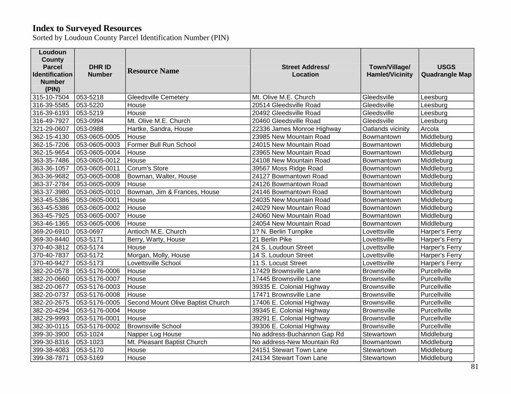
Index to Surveyed Resources Sorted by Loudoun County Parcel Identification Number (PIN)
81
Loudoun County Parcel
Identification Number
(PIN)
DHR ID Number
Resource Name Street Address/
Location Town/Village/
Hamlet/Vicinity USGS
Quadrangle Map
315-10-7504 053-5218 Gleedsville Cemetery Mt. Olive M.E. Church Gleedsville Leesburg
316-39-5585 053-5220 House 20514 Gleedsville Road Gleedsville Leesburg
316-39-6193 053-5219 House 20492 Gleedsville Road Gleedsville Leesburg
316-49-7927 053-0994 Mt. Olive M.E. Church 20460 Gleedsville Road Gleedsville Leesburg
321-29-0607 053-0988 Hartke, Sandra, House 22336 James Monroe Highway Oatlands vicinity Arcola
362-15-4130 053-0605-0005 House 23985 New Mountain Road Bowmantown Middleburg
362-15-7206 053-0605-0003 Former Bull Run School 24015 New Mountain Road Bowmantown Middleburg
362-15-9654 053-0605-0004 House 23965 New Mountain Road Bowmantown Middleburg
363-35-7486 053-0605-0012 House 24108 New Mountain Road Bowmantown Middleburg
363-36-1057 053-0605-0011 Corum's Store 39567 Moss Ridge Road Bowmantown Middleburg
363-36-9682 053-0605-0008 Bowman, Walter, House 24127 Bowmantown Road Bowmantown Middleburg
363-37-2784 053-0605-0009 House 24126 Bowmantown Road Bowmantown Middleburg
363-37-3980 053-0605-0010 Bowman, Jim & Frances, House 24146 Bowmantown Road Bowmantown Middleburg
363-45-5386 053-0605-0001 House 24035 New Mountain Road Bowmantown Middleburg
363-45-5386 053-0605-0002 House 24029 New Mountain Road Bowmantown Middleburg
363-45-7925 053-0605-0007 House 24060 New Mountain Road Bowmantown Middleburg
363-46-1365 053-0605-0006 House 24054 New Mountain Road Bowmantown Middleburg
369-20-6910 053-0697 Antioch M.E. Church 1? N. Berlin Turnpike Lovettsville Harper's Ferry
369-30-8440 053-5171 Berry, Warty, House 21 Berlin Pike Lovettsville Harper's Ferry
370-40-3812 053-5174 House 24 S. Loudoun Street Lovettsville Harper's Ferry
370-40-7837 053-5172 Morgan, Molly, House 14 S. Loudoun Street Lovettsville Harper's Ferry
370-40-9427 053-5173 Lovettsville School 11 S. Locust Street Lovettsville Harper's Ferry
382-20-0578 053-5176-0006 House 17429 Brownsville Lane Brownsville Purcellville
382-20-0660 053-5176-0007 House 17445 Brownsville Lane Brownsville Purcellville
382-20-0677 053-5176-0003 House 39335 E. Colonial Highway Brownsville Purcellville
382-20-0737 053-5176-0008 House 17471 Brownsville Lane Brownsville Purcellville
382-20-2675 053-5176-0005 Second Mount Olive Baptist Church 17406 E. Colonial Highway Brownsville Purcellville
382-20-4294 053-5176-0004 House 39345 E. Colonial Highway Brownsville Purcellville
382-29-9993 053-5176-0001 House 39291 E. Colonial Highway Brownsville Purcellville
382-30-0115 053-5176-0002 Brownsville School 39306 E. Colonial Highway Brownsville Purcellville
399-30-3900 053-1024 Napper Log House No address-Buchannon Gap Rd Stewartown Middleburg
399-30-8316 053-1023 Mt. Pleasant Baptist Church No address-New Mountain Rd Bowmantown Middleburg
399-38-4083 053-5170 House 24151 Stewart Town Lane Stewartown Middleburg
399-38-7871 053-5169 House 24134 Stewart Town Lane Stewartown Middleburg

Index to Surveyed Resources Sorted by Loudoun County Parcel Identification Number (PIN)
82
Loudoun County Parcel
Identification Number
(PIN)
DHR ID Number
Resource Name Street Address/
Location Town/Village/
Hamlet/Vicinity USGS
Quadrangle Map
399-39-5123 053-5168 House 39245 Buchannon Gap Road Stewartown Middleburg
418-30-0780 053-5196 Gaskins, Clint, House 12 W. Virginia Ave. Hamilton Purcellville
418-30-1846 053-5195 Fields, Mary Clark, House 102 W. Virginia Ave. Hamilton Purcellville
418-38-9881 053-5197 Mt. Zion M.E. Church 250 W. Virginia Ave. Hamilton Purcellville
418-39-6983 053-5184 Collins House 70 Laycock Street Hamilton Purcellville
418-39-8199 053-5194 House 118 Maryland Ave. Hamilton Purcellville
418-48-3133 053-5185 Clark, Eugene, House 115 Ivandale Road Hamilton Purcellville
418-48-3446 053-5186 Harvey, Fannie, House 119 North Ivandale Road Hamilton Purcellville
418-48-7061 053-5188 Clark, Howard Willard, House 124 Delaware Ave. Hamilton Purcellville
418-48-7445 053-5187 Johnson, Charley, House 120 N. Ivandale Road Hamilton Purcellville
418-48-7800 053-5198 Rowe, George, House 284 W. Virginia Ave. Hamilton Purcellville
418-49-2212 053-5190 House 258 Maryland Avenue Hamilton Purcellville
418-49-4506 053-5192 Lucas, Mary Jane, House 242 Maryland Ave. Hamilton Purcellville
418-49-5002 053-5191 Store, west of 242 Maryland Ave. Hamilton Purcellville
418-49-5240 053-5189 House 102 Delaware Avenue Hamilton Purcellville
418-49-6012 053-5193 House 232 Maryland Ave. Hamilton Purcellville
418-49-9302 053-5183 Mt. Zion M. E. Church Parsonage 114 Maryland Street Hamilton Purcellville
421-10-6969 053-0174 Mount Gilead Township School 38747 Hughesville Road Hughesville Lincoln
421-10-6969 053-0464 Hughesville Baptist Church 38747 Hughesville Road Hughesville Lincoln
432-17-4722 053-0584 Moore, Frank House 38446 John Mosby Highway Dover Middleburg
442-16-4657 053-5175 Mt. Sinai Free Baptist Cemetery Britain Rd. & Laramy Ln. Britain/Guinea Harper's Ferry
455-35-4275 053-5225 Trammel, John, House 37646 Cooksville Road Lincoln Lincoln
455-35-9263 053-0845 Lincoln “Colored” School 37706 Cooksville Road Lincoln Lincoln
455-36-2851 053-0205 Grace M.E. Church West end of Brooks Lane Lincoln Lincoln
455-36-6170 053-0825 Lucas House 37758 Brooks Lane Lincoln Lincoln
455-36-6782 053-0823 Bell, Harold, House 37764 Brooks Lane Lincoln Lincoln
455-36-7114 053-0843 Brent House 37766 Brooks Lane Lincoln Lincoln
459-16-3324 053-5244 Hicks, John Robert, House 20013 Lincoln Road North Fork Lincoln
463-20-1169 053-5238 House 38062 Lime Kiln Road Marble Quarry Lincoln
463-29-4367 053-5240 House 21438 Steptoe Hill Road Marble Quarry Lincoln
465-26-3702 053-5086 Second Marble Quarry School 22282 Sam Fred Road Berryman Lincoln
465-29-7760 053-5239 Marble Quarry, Ruins of Hamlet of Lime Kiln Road Marble Quarry Lincoln
467-26-0518 053-5155 Hall's Park 23171 Carters Farm Lane Macsville Middleburg
468-35-0282 053-5152 Fisher House & Workshop 37603-37609 John Mosby Hwy Macsville Middleburg

Index to Surveyed Resources Sorted by Loudoun County Parcel Identification Number (PIN)
83
Loudoun County Parcel
Identification Number
(PIN)
DHR ID Number
Resource Name Street Address/
Location Town/Village/
Hamlet/Vicinity USGS
Quadrangle Map
468-35-1275 053-5153 House 37615 John Mosby Highway Macsville Middleburg
468-45-3205 053-5154 Fisher, David, House 37632 John Mosby Highway Macsville Middleburg
488-18-2017 286-5003 Willing Workers Hall/ Purcellville “Colored” School
530 S. 20th Street Purcellville Purcellville
488-19-0189 286-5001-0231 House 330 G Street Purcellville Purcellville
488-19-1191 286-5001-0232 House 400 E. G Street Purcellville Purcellville
488-19-3893 286-5001-0230 Grace Annex M. E. Church 441 E. G Street Purcellville Purcellville
488-28-7322 286-5001-0107 Pierce, William “Billy,” Boyhood Home 331 G Street Purcellville Purcellville
489-48-2667 053-5201 House 730 S. 20th Street Purcellville Purcellville
489-48-3435 053-5203 House 760 S. 20th Street Purcellville Purcellville
489-48-3845 053-5202 House 750 20th Street Purcellville Purcellville
489-48-4455 053-5200 House 710 20th Street Purcellville Purcellville
489-48-7172 053-5199 Carver, George Washington, School 700 S. 15th Street Purcellville Purcellville
500-30-6707 053-0932 Berryman, Raymond & Mattie, House 37568 Berryman Road Berryman Lincoln
500-39-8908 053-6037 Vacant House, Berryman Lane West of Berryman Lane Berryman Lincoln
503-30-9576 053-5151 Brown House 23320 Forsythia Lane Macsville Middleburg
503-35-2245 053-0589 Maryland Heights 23363 John Mosby Highway Brown's Corner Middleburg
503-35-2323 053-5149 House 23375 Sam Fred Road Brown's Corner Middleburg
503-35-2323 053-5150 House 23381 John Mosby Highway Brown's Corner Middleburg
503-35-4209 053-0588 Brown, Chauncey DePew, House 37040 John Mosby Highway Brown's Corner Middleburg
503-40-9105 053-0587 Smith Family House 37600 John Mosby Highway Macsville Middleburg
518-28-8780 053-5207 House 15469 Ashbury Church Road Short Hill Purcellville
518-39-2864 053-5204 House 15411 Ashbury Church Road Short Hill Purcellville
518-39-2864 053-5205 House 15407 Ashbury Church Road Short Hill Purcellville
518-39-6445 053-0909 Asbury M.E. Church Ashbury Church Road - Rte 718 Hillsboro Purcellville
518-39-6504 053-5206 Hillsboro “Colored” School (former) 15425 Ashbury Church Road Short Hill Purcellville
538-39-1519 259-0162-0011 Asbury M.E. Church 105 N. Jay Street Middleburg Middleburg
555-15-1147 291-5012 Flave, Clark, House 2 Chamblin Round Hill Round Hill
556-37-6024 053-5230 Hayman, Oscar "Friday," House 35816 Hayman Lane Round Hill Round Hill
556-45-1332 053-5231 Grayson, William, House 35803 Hayman Lane Round Hill Round Hill
556-45-1404 053-5232 Webster, Frank, House 35809 Hayman Lane Round Hill Round Hill
570-10-6070 259-5065 House 106 Windy Hill Road Windy Hill Middleburg
570-10-6192 259-5062 House 113 Windy Hill Road Windy Hill Middleburg
570-10-6884 259-5060 House 109 Windy Hill Road Windy Hill Middleburg

Index to Surveyed Resources Sorted by Loudoun County Parcel Identification Number (PIN)
84
Loudoun County Parcel
Identification Number
(PIN)
DHR ID Number
Resource Name Street Address/
Location Town/Village/
Hamlet/Vicinity USGS
Quadrangle Map
570-10-6884 259-5061 House 115 Windy Hill Road Windy Hill Middleburg
570-10-6884 259-5063 House 111 Windy Hill Road Windy Hill Middleburg
570-10-7578 259-5059 House 107 Windy Hill Road Windy Hill Middleburg
570-10-7660 259-5066 House 7 Windy Hill Road Windy Hill Middleburg
570-10-7660 259-5064 House 105 Windy Hill Road Windy Hill Middleburg
570-10-7660 259-5067 House 5 Windy Hill Road Windy Hill Middleburg
570-10-7660 259-5069 House 9 Windy Hill Road Windy Hill Middleburg
570-10-8347 259-5068 House 1006 West Washington Street Windy Hill Middleburg
570-10-9170 259-5058 House 1000 Washington Street Windy Hill Middleburg
584-20-1656 291-5011 Mt. Zion Baptist Church 28 Main Street Round Hill Round Hill
584-20-4165 291-5004 House 25 Main Street Round Hill Round Hill
584-20-7775 291-5005 House 5 Cedar Street Round Hill Round Hill
584-20-8397 291-5006 House 13 Cedar Street Round Hill Round Hill
584-20-9186 291-5008 African Methodist Episcopal Church 18 Bridge Street Round Hill Round Hill
584-20-9272 291-5010 Clark, Rodney & Meada, House 14 Bridge Street Round Hill Round Hill
584-20-9279 291-5009 Beaner, Nicolas, House 16 Bridge Street Round Hill Round Hill
584-29-8639 291-5001 Henderson, Jim, House 8 High Street Round Hill Round Hill
584-29-9440 291-5002 House 4 High Street Round Hill Round Hill
584-29-9942 291-5003 House 2 High Street Round Hill Round Hill
585-40-4704 053-5234 Lewis House 35757 Hayman Lane Round Hill Round Hill
585-40-8612 053-5233 House 35771 Hayman Lane Round Hill Round Hill
588-16-4980 053-5138 Powell's Grove United Meth. Church 19100 Airmont Road Powell's Grove Bluemont
588-47-1765 053-5236 Campbell House 18826 Airmont Road Round Hill - vic. Bluemont
596-25-2318 053-5099-0010 Banneker School 35231 Snake Hill Road St. Louis Bluemont
596-25-6595 053-5099-0004 Jackson, Mary Jane, House 35262 Snake Hill Road St. Louis Bluemont
596-25-7434 053-5099-0009 Store 35285 Snake Hill Road St. Louis Bluemont
596-25-9397 053-1049 Mt. Zion Baptist Church 35286 Snake Hill Road St. Louis Bluemont
596-26-1383 053-5099-0008 Strickland, Dwight, House 35307 Snake Hill Road St. Louis Bluemont
596-26-3085 053-5099-0007 Grant, M. Louise, House 35327 Snake Hill Road St. Louis Bluemont
596-37-3190 053-5099-0006 St. Louis School 35430 Hamlin School Lane St. Louis Bluemont
596-46-8529 053-5099-0005 House 22032 St. Louis Road St. Louis Bluemont
597-46-5120 053-5099-0017 House 22326 St. Louis Road St. Louis Bluemont
621-19-9193 053-5099-0016 Basil, Charles & Armeata, House 22317 St. Louis Road St. Louis Bluemont
621-20-2998 053-5099-0001 House 22209 McQuay Heights Lane St. Louis Bluemont

Index to Surveyed Resources Sorted by Loudoun County Parcel Identification Number (PIN)
85
Loudoun County Parcel
Identification Number
(PIN)
DHR ID Number
Resource Name Street Address/
Location Town/Village/
Hamlet/Vicinity USGS
Quadrangle Map
621-20-4456 053-5099-0012 Mattingly, Don E., Jr., House 22241 St. Louis Road St. Louis Bluemont
621-20-4967 053-5099-0013 House 22249 St. Louis Road St. Louis Bluemont
621-20-7255 053-5099-0011 Madison House 22240 St. Louis Road St. Louis Bluemont
621-20-9187 053-5099-0002 Trammell, Irene H., House 22202 St. Louis Road St. Louis Bluemont
621-29-8931 053-5099-0014 House 22256 Newlin Mill Road St. Louis Bluemont
621-29-9010 053-5099-0015 Smith, Willie & Grace Jackson House 22309 St. Louis Road St. Louis Bluemont
621-30-8030 053-5099-0003 House 22181 St. Louis Road St. Louis Bluemont
633-36-6922 053-1060 Scipio, Beatrice, House 18556 Foggy Bottom Road Murphy's Corner Bluemont
633-36-6966 053-5141-0005 House 18526 Foggy Bottom Road Murphy's Corner Bluemont
633-36-7563 053-5141-0006 House 34069 Snickersville Turnpike Murphy's Corner Bluemont
633-36-8765 053-5141-0007 Bluemont First Baptist Church 34081 Snickersville Turnpike Murphy's Corner Bluemont
633-36-9390 053-5141-0004 House 34058 Snickersville Turnpike Murphy's Corner Bluemont
633-37-1431 053-5141-0008 House 34117 Snickersville Turnpike Murphy's Corner Bluemont
633-37-1480 053-5141-0003 House 34090 Snickersville Turnpike Murphy's Corner Bluemont
633-46-8915 053-5141-0001 House 34056 Snickersville Turnpike Murphy's Corner Bluemont
633-47-2137 053-5141-0002 House 34062 Snickersville Turnpike Murphy's Corner Bluemont
635-49-4004 053-5139 Walsh Farm Slave Quarter 19312 Walsh Farm Lane Paxson/Berkley Bluemont
637-45-0287 053-5137 Austin Grove M.E. Church 33999 Austin Grove Road Rock Hill Bluemont
642-35-0533 053-5116-0005 House, West of 34001 Welbourne Road Willisville Bluemont
642-35-0757 053-5116-0007 House 34007 Welbourne Road Willisville Bluemont
642-35-3622 053-5116-0010 House 34055 Welbourne Road Willisville Bluemont
642-35-4345 053-5116-0009 Willisville Store 34049 Welbourne Road Willisville Bluemont
649-48-6721 053-5140 Butcher's Hollow House 33691 Snickersville Turnpike (?) Butcher's Hollow Bluemont
655-38-0759 053-0062-0002 House 20999 Greengarden Road Howardsville Bluemont
655-38-3732 053-0062-0006 House 20991 Greengarden Road Howardsville Bluemont
655-38-3899 053-0062-0003 House 20929 Greengarden Rd. Howardsville Bluemont
655-38-5637 053-0062-0004 House 20965 Greengarden Road Howardsville Bluemont
655-38-5907 053-0062-0005 Reid, Gracie, House 21011 Greengarden Road Howardsville Bluemont
655-49-2132 053-0062-0001 House 20857 Greengarden Road Howardsville Bluemont
658-30-3064 053-5116-0014 Willisville School (former) 33910 Willisville Road Willisville Bluemont
658-30-3593 053-5116-0013 House 33960 Welbourne Road Willisville Bluemont
658-30-5286 053-5116-0012 Gaskin, Rosalee, House 33974 Welbourne Road Willisville Bluemont
658-30-5629 053-5116-0015 House 33995 Welbourne Road Willisville Bluemont
658-30-6465 053-5116-0002 Abandoned House, Welbourne Rd. Welbourne Rd. Willisville Bluemont

Index to Surveyed Resources Sorted by Loudoun County Parcel Identification Number (PIN)
86
Loudoun County Parcel
Identification Number
(PIN)
DHR ID Number
Resource Name Street Address/
Location Town/Village/
Hamlet/Vicinity USGS
Quadrangle Map
658-30-7260 053-5116-0003 House 33973 Welbourne Road Willisville Bluemont
658-30-7485 053-5116-0011 House 33978 Welbourne Road Willisville Bluemont
658-30-7707 053-5116-0006 House 34001 Welbourne Road Willisville Bluemont
658-30-8453 053-5116-0004 Abandoned House between 33995 & 34001 Welbourne Rd Willisville Bluemont
658-30-8643 053-5116-0008 House 34017 Welbourne Road Willisville Bluemont
658-30-9380 053-1043 Willisville Chapel 34008 Welbourne Road Willisville Bluemont
658-40-5003 053-5116-0001 House 33911 Welbourne Road Willisville Bluemont
no tax id # 053-5097 House (demolished) 25600 Elk Lick Road Conklin Arcola
no tax id # 053-5227 House (demolished) 25974 Elk Lick Road Conklin Arcola

87
Chronological List of Surveyed Resources DHR ID# PROPERTY NAME YEAR BUILT
053-5224
House, 46531 Harry Byrd Highway
1770 ca
053-0932
Berryman, Raymond & Mattie, House
Wilson, James B., House
1790 ca
053-932
Berryman, Raymond, House
Wilson, James B., House
1790 ca
053-5139
Walsh Farm Slave Quarter
1790 ca
053-0984
Stone Slave Quarters
Farm, 24837 Evergreen Mills Rd
1800 ca
053-5205
House, 15407 Ashbury Church Road
1800 ca
053-5098
House, 40455 Quarterbranch Road
1800 ca
053-0587
Smith, James E., House
1800 ca
053-0934
Hooe, James C., House
1820 ca
053-1024
Napper Log House
Log House, Buchannon Gap Road
1820 ca
053-0584
Moore, Frank, House
Moore, Glandwood D. and Evelyn L., House
Toll House
1820 ca
259-0162-0011
Asbury Methodist Episcopal Church
1829 ca
053-0588
Brown, Chauncey Depew, House
Brown, Joseph and Sarah, House
Smithwick House
1830 ca
053-5141-0004
House, 34058 Snickersville Turnpike
1830 ca
053-0589
Fieldview
Maryland Heights
Goehring House
1837

Chronological List of Surveyed Resources DHR ID# PROPERTY NAME YEAR BUILT
88
053-5116-0008
House, 34017 Welbourne Road
1840 ca
053-0062-0005
Reid, Gracie, House
1840 ca
053-5087-0010
House, 40991 Red Hill Road
1850 ca
053-5116-0015
House, 33995 Welbourne Road
1850 ca
053-6037
Vacant house, Berryman Lane
1850 ca
053-5230
Hayman, Oscar "Friday", House
1850 ca
291-5007
Redman, Dorsey House
House, 24 Bridge Street
1850 ca
053-0845
Lincoln "Colored" School
1865
053-0464
053-0002 (other DHR ID#)
Hughesville Baptist Church
1870 ca
053-0605-0004
House, 23965 New Mountain Road
1870 ca
053-0988
Charles Riticor House
Sandra Hartke House
House at 22336 James Monroe Highway
1870 ca
286-5001-0107
House, 331 G Street
House, 331 Hill Street
William "Billy" Pierce Boyhood Home
1870 ca
053-5189
House, 102 Delaware Avenue
1870
053-5240
House, 21438 Steptoe Hill Road
1870 ca
053-5236
Campbell House
1870 ca
053-5232
Webster, Frank, House
1870 ca
053-5099-0006
St. Louis School
Hamlin, Addie, House
1870 ca

Chronological List of Surveyed Resources DHR ID# PROPERTY NAME YEAR BUILT
89
053-5099-0011
Dower, Nikia Rae, House
Madison House
1870
053-0174
Mount Gilead Township School
Former School, Next to 38747 Hughesville Road
1872 ca
053-0843
House, 37766 Cooksville Road
Brent House
1874
053-1060
053-5141-0009 (other DHR ID#)
Scipio, Christopher and Rose, House
Scott, Robert, L., House
Scipio, Beatrice, House
1875
053-0322
053-0012-0470 (other DHR ID#)
Mount Pleasant Baptist Church and Cemetery
1880
053-0697
Antioch Methodist Episcopal Church
1880 ca
053-5175
Mt. Sinai Free Baptist Cemetery and Church site
1880 ca
053-5116-0001
House, 33911 Welbourne Road
1880 ca
053-0605-0010
Bowman, Berkley, House
Jackson, Mary, House
Bowman, Jim and Frances, House
1880 ca
053-5190
House, 258 Maryland Avenue
1880 ca
053-5173
Lovettsville School
1880 ca
053-0062-0003
House, 20929 Greengarden Road
1880 ca
053-5238
House, 38062 Lime Kiln Road
1880 ca
053-5151
House, 23320 Forsythia Lane
Brown House
1880 ca
053-5172
Morgan, Molly House
Brown, William House
1880 ca
053-0825
Lucas House
House, 37758 Brooks Lane
1880
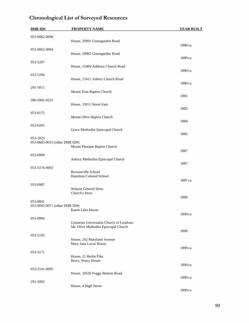
Chronological List of Surveyed Resources DHR ID# PROPERTY NAME YEAR BUILT
90
053-0062-0006
House, 20991 Greengarden Road
1880 ca
053-0062-0004
House, 20965 Greengarden Road
1880 ca
053-5207
House, 15469 Ashbury Church Road
1880 ca
053-5204
House, 15411 Asbury Church Road
1880 ca
291-5011
Mount Zion Baptist Church
1881
286-5001-0231
House, 330 G Street East
1882
053-0175
Mount Olive Baptist Church
1884
053-0205
Grace Methodist Episcopal Church
1885
053-1023
053-0605-0013 (other DHR ID#)
Mount Pleasant Baptist Church
1887
053-0909
Asbury Methodist Episcopal Church
1887
053-5176-0002
Brownsville School
Hamilton Colored School
1887 ca
053-0987
Watson General Store
Church's Store
1888
053-0841
053-0002-0071 (other DHR ID#)
Karen Liles House
1890 ca
053-0994
Unitarian Universalist Church of Loudoun
Mt. Olive Methodist Episcopal Church
1890
053-5192
House, 242 Maryland Avenue
Mary Jane Lucas House
1890 ca
053-5171
House, 21 Berlin Pike
Berry, Warty House
1890 ca
053-5141-0005
House, 18526 Foggy Bottom Road
1890 ca
291-5002
House, 4 High Street
1890 ca

Chronological List of Surveyed Resources DHR ID# PROPERTY NAME YEAR BUILT
91
053-5099-0015
Smith, Willie A. and Grace Jackson, House
1890 ca
053-5183
Mount Zion Methodist Episcopal Church Parsonage
1890
053-5099-0009
Store, 35285 Snake Hill Road
1890 ca
053-5206
Hillsboro "Colored" School House
1890 ca
053-5186
Harvey, Fannie, House
1890 ca
291-5010
Clark, Rodney & Meada, House
Ferrell, Dixie & Garland, House
Mallory, Monzella & Allen, House
1890 ca
291-5009
Beaner, Nicolas House
1890 ca
053-5087-0004
House, 22579 Watson Road
1890 ca
053-5087-0002
House, 22503 Watson Road
1890 ca
053-5099-0014
House, 22256 Newlin Mill Road
1890 ca
053-5141-0006
House, 34069 Snickersville Turnpike
1890
053-5116-0003
House, 33973 Welbourne Road
1890 ca
053-5116-0010
House, 34055 Welbourne Road
1890 ca
053-0605-0008
Bowman, Walter, House
House, 24127 Bowmantown Road
Twin Willows
1890 ca
053-0823
Bell, Harold House
1890 ca
053-0062-0002
House, 20999 Greengarden Road
1890 ca
053-5176-0005
The Second Mount Olive Church
1892
291-5008
African Methodist Episcopal Church
House, 18 Bridge Street
1892

Chronological List of Surveyed Resources DHR ID# PROPERTY NAME YEAR BUILT
92
053-1049
053-5099-0019 (other DHR ID#)
Mount Zion Baptist Church
St. Louis New School Baptist Church
1893
053-5218
Gleedsville Cemetery
1893
053-0899
Union Church
First Baptist Church, Sycolin
1894
053-5239
Ruins of Hamlet of Marble Quarry
Ruins of Zion Baptist Church
Ruins of dwelling, Marble Quarry
1896
053-5138
Powell's Grove United Methodist Church
1897 ca
286-5002
Loudoun County Emancipation Association
Emancipation Grounds
1898
053-5099-0005
House, 22032 St. Louis Road
1899
053-5219
House, 20492 Gleedsville Road
1900 ca
053-5097
House, 25600 Elk Lick Road
1900 ca
053-5195
Fields, Mary Clark, House
House, 102 Rogers Street
1900 ca
053-5196
Gaskins, Clint, House
House, 112 West Virginia Avenue
1900 ca
053-5184
Collins House
1900 ca
053-5225
Trammel, John House
1900 ca
053-5153
House, 37615 John Mosby Highway
1900 ca
053-5176-0003
House, 39335 East Colonial Highway
1900 ca
053-5087-0007
Thornton House
1900 ca
053-5217
House, 20100 Sycolin Road
1900 ca

Chronological List of Surveyed Resources DHR ID# PROPERTY NAME YEAR BUILT
93
053-5099-0017
House, 22326 St. Louis Road
1900 ca
053-5099-0003
House, 22181 St. Louis Road
1900 ca
291-5003
House, 2 High Street
1900 ca
291-5004
House, 25 Main Street
1900 ca
053-5213
House, 104 Dominion Lane
1900 ca
053-5212
House, 102 Locust Lane
1900 ca
053-5209
House, 102 Hall Road
1900 ca
053-5141-0003
House, 34090 Snickersville Turnpike
1900
053-0605-0009
House, 24126 Bowmantown Road
1900 ca
053-5086
New Zion Baptist Church
Second Marble Quarry School (former)
1900 ca
053-5116-0002
Abandoned House, Welbourne Road
1900 ca
053-5116-0005
House, west of 34001 Welbourne Road
1900 ca
053-5116-0004
Abandoned House, between 33995 & 34001 Welbourne Road
1900 ca
053-5116-0012
Rosalee Gaskin House
1900 ca
291-5001
Henderson, Jim, House
1900
053-5099-0004
Jackson, Mary Jane, House
1900
259-5060
House, 109 Windy Hill Road
1900 ca
259-5063
House, 111 Windy Hill Road
1900 ca
259-5066
House, 7 Windy Hill Road
1900 ca
259-5067
House, 5 Windy Hill Road
1900 ca

Chronological List of Surveyed Resources DHR ID# PROPERTY NAME YEAR BUILT
94
053-5233
House, 35771 Hayman Lane
1900 ca
291-5012
Clark Flave House
1900 ca
053-5174
House, 24 South Loudoun Street
1900 ca
053-0062-0001
House, 20857 Greengarden Road
1900 ca
053-5191
Former store, west of 242 Maryland Avenue
1900 ca
053-5193
House, 232 Maryland Avenue
1900 ca
053-5220
House, 20514 Gleedsville Road
1900 ca
053-5149
House, 23375 Sam Fred Road
1900 ca
053-5214
Oak Grove Baptist Cemetery
1902
053-5244
Story Book Farm
Hicks, John Robert, House
1903
053-5216
House, 20028 Sycolin Road
1904
053-0605-0007
House, 24060 New Mountain Road
1909
053-0605-0003
Bull Run School (former)
House, 24015 New Mountain Road
1909
053-0605-0006
House, 24054 New Mountain Road
1909
053-5150
House, 23381 Sam Fred Road
1910 ca
053-5188
Clark, Howard Willard House
House, 124 Delaware Avenue
1910 ca
053-5087-0005
Church Family House
1910
291-5006
House, 13 Cedar Street
1910 ca

Chronological List of Surveyed Resources DHR ID# PROPERTY NAME YEAR BUILT
95
053-5087-0008
House, 40852 Red Hill Road
1910 ca
053-5176-0006
House, 17429 Brownsville Lane
1910 ca
053-5099-0008
Strickland, Dwight, House
1910 ca
053-5099-0012
Mattingly, Don E., Jr., House
1910 ca
053-5200
House, 710 20th Street
1910
053-5208
House, 220 Oakgrove Road
1910 ca
053-5170
House, 24151 Stewart Town Lane
1910 ca
053-5176-0007
House, 17445 Brownsville Lane
1910 ca
053-5176-0008
House, 17471 Brownsville Lane
1910 ca
053-5116-0009
Willisville Store
"The Store House of Willisville"
1910 ca
053-5187
Johnson, Charley House
House, 120 North Ivandale Road
1910 ca
053-5137
Austin Grove Methodist Episcopal Church
Austin Grove Midway United Methodist Church
1911
053-5087-0003
Watson Hall
The Hall
Watson Mountain Church
1913
053-5223
Nokes House
1913
053-5231
Grayson, William, House
Grayson, Pastor Robert, House
1915
286-5003
Purcellville "Colored" School
Willing Workers Hall
Lyles Funeral Service
1919
053-5194
House, 118 Maryland Avenue
1920 ca
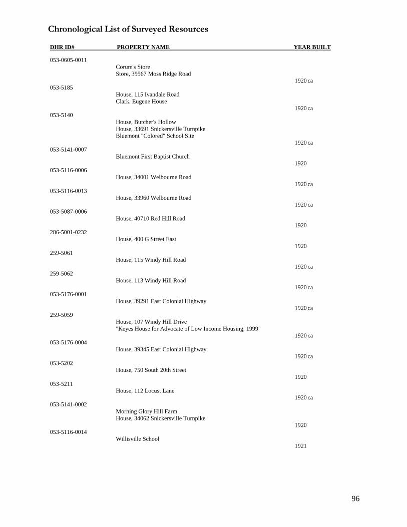
Chronological List of Surveyed Resources DHR ID# PROPERTY NAME YEAR BUILT
96
053-0605-0011
Corum's Store
Store, 39567 Moss Ridge Road
1920 ca
053-5185
House, 115 Ivandale Road
Clark, Eugene House
1920 ca
053-5140
House, Butcher's Hollow
House, 33691 Snickersville Turnpike
Bluemont "Colored" School Site
1920 ca
053-5141-0007
Bluemont First Baptist Church
1920
053-5116-0006
House, 34001 Welbourne Road
1920 ca
053-5116-0013
House, 33960 Welbourne Road
1920 ca
053-5087-0006
House, 40710 Red Hill Road
1920
286-5001-0232
House, 400 G Street East
1920
259-5061
House, 115 Windy Hill Road
1920 ca
259-5062
House, 113 Windy Hill Road
1920 ca
053-5176-0001
House, 39291 East Colonial Highway
1920 ca
259-5059
House, 107 Windy Hill Drive
"Keyes House for Advocate of Low Income Housing, 1999"
1920 ca
053-5176-0004
House, 39345 East Colonial Highway
1920 ca
053-5202
House, 750 South 20th Street
1920
053-5211
House, 112 Locust Lane
1920 ca
053-5141-0002
Morning Glory Hill Farm
House, 34062 Snickersville Turnpike
1920
053-5116-0014
Willisville School
1921
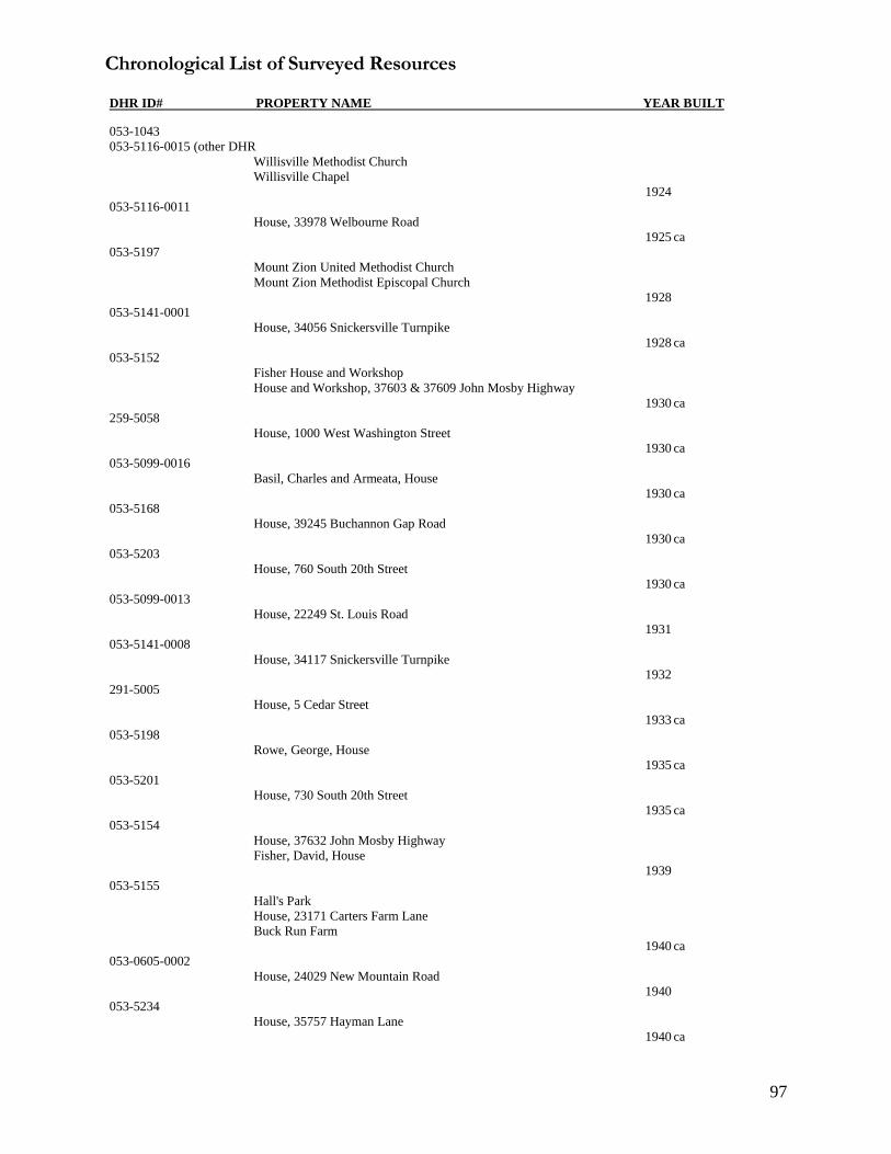
Chronological List of Surveyed Resources DHR ID# PROPERTY NAME YEAR BUILT
97
053-1043
053-5116-0015 (other DHR
Willisville Methodist Church
Willisville Chapel
1924
053-5116-0011
House, 33978 Welbourne Road
1925 ca
053-5197
Mount Zion United Methodist Church
Mount Zion Methodist Episcopal Church
1928
053-5141-0001
House, 34056 Snickersville Turnpike
1928 ca
053-5152
Fisher House and Workshop
House and Workshop, 37603 & 37609 John Mosby Highway
1930 ca
259-5058
House, 1000 West Washington Street
1930 ca
053-5099-0016
Basil, Charles and Armeata, House
1930 ca
053-5168
House, 39245 Buchannon Gap Road
1930 ca
053-5203
House, 760 South 20th Street
1930 ca
053-5099-0013
House, 22249 St. Louis Road
1931
053-5141-0008
House, 34117 Snickersville Turnpike
1932
291-5005
House, 5 Cedar Street
1933 ca
053-5198
Rowe, George, House
1935 ca
053-5201
House, 730 South 20th Street
1935 ca
053-5154
House, 37632 John Mosby Highway
Fisher, David, House
1939
053-5155
Hall's Park
House, 23171 Carters Farm Lane
Buck Run Farm
1940 ca
053-0605-0002
House, 24029 New Mountain Road
1940
053-5234
House, 35757 Hayman Lane
1940 ca

Chronological List of Surveyed Resources DHR ID# PROPERTY NAME YEAR BUILT
98
053-5227-0011
House, 25974 Elk Lick Road
1940 ca
053-5226
House, 25926 Elk Lick Road
1940 ca
053-0605-0005
House, 23985 New Mountain Road
1940 ca
053-5099-0002
Trammell, Irene H., House
1940
053-5229
House, 43035 Braddock Road
1940 ca
053-5227
House, 25974 Elk Lick Road
1940 ca
259-5068
House, 1006 West Washington Street
1940 ca
053-5210
House, 105 Hall Road
1944
053-5668
House at 25039 Elk Lick Rd
1945 ca
053-5222
House, 45805 Jona Drive
1945
053-5087-0001
House, 22610 Watson Road
1945
053-5669
House at 25047 Elk Lick Rd
1946 ca
053-5199
Carver School
1946
053-5099-0010
Banneker School
School, 35231 Snake Hill Road
1948
053-0605-0012
House, 24108 New Mountain Road
1949
286-5001-0230
Grace Annex Church
1949
053-5670
House at 25055 Elk Lick Rd
1949 ca
053-5228
House, 26014 Elk Lick Road
1950 ca
259-5065
House, 106 Windy Hill
1950 ca

Chronological List of Surveyed Resources DHR ID# PROPERTY NAME YEAR BUILT
99
259-5064
House, 105 Windy Hill Drive
1950 ca
259-5069
House, 9 Windy Hill Road
1950 ca
053-5169
House, 24134 Stewart Town Lane
1954 ca
053-5099-0007
Grant, M. Louise, House
1955
053-5116-0007
House, 34007 Welbourne Road
1956
053-5087-0009
First Baptist Church
1957
053-0605-0001
House, 24035 New Mountain Road
1959 ca
053-5099-0001
House, 22209 McQuay Heights Lane
1962
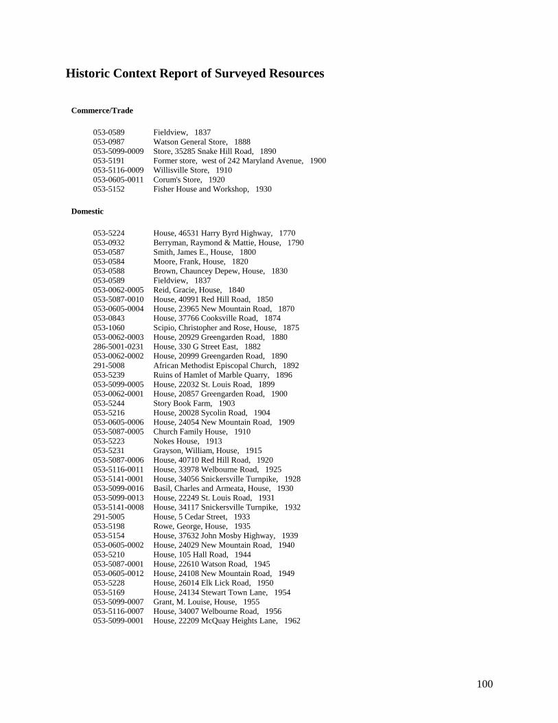
100
Historic Context Report of Surveyed Resources
Commerce/Trade
053-0589 Fieldview, 1837
053-0987 Watson General Store, 1888
053-5099-0009 Store, 35285 Snake Hill Road, 1890
053-5191 Former store, west of 242 Maryland Avenue, 1900
053-5116-0009 Willisville Store, 1910
053-0605-0011 Corum's Store, 1920
053-5152 Fisher House and Workshop, 1930
Domestic
053-5224 House, 46531 Harry Byrd Highway, 1770
053-0932 Berryman, Raymond & Mattie, House, 1790
053-0587 Smith, James E., House, 1800
053-0584 Moore, Frank, House, 1820
053-0588 Brown, Chauncey Depew, House, 1830
053-0589 Fieldview, 1837
053-0062-0005 Reid, Gracie, House, 1840
053-5087-0010 House, 40991 Red Hill Road, 1850
053-0605-0004 House, 23965 New Mountain Road, 1870
053-0843 House, 37766 Cooksville Road, 1874
053-1060 Scipio, Christopher and Rose, House, 1875
053-0062-0003 House, 20929 Greengarden Road, 1880
286-5001-0231 House, 330 G Street East, 1882
053-0062-0002 House, 20999 Greengarden Road, 1890
291-5008 African Methodist Episcopal Church, 1892
053-5239 Ruins of Hamlet of Marble Quarry, 1896
053-5099-0005 House, 22032 St. Louis Road, 1899
053-0062-0001 House, 20857 Greengarden Road, 1900
053-5244 Story Book Farm, 1903
053-5216 House, 20028 Sycolin Road, 1904
053-0605-0006 House, 24054 New Mountain Road, 1909
053-5087-0005 Church Family House, 1910
053-5223 Nokes House, 1913
053-5231 Grayson, William, House, 1915
053-5087-0006 House, 40710 Red Hill Road, 1920
053-5116-0011 House, 33978 Welbourne Road, 1925
053-5141-0001 House, 34056 Snickersville Turnpike, 1928
053-5099-0016 Basil, Charles and Armeata, House, 1930
053-5099-0013 House, 22249 St. Louis Road, 1931
053-5141-0008 House, 34117 Snickersville Turnpike, 1932
291-5005 House, 5 Cedar Street, 1933
053-5198 Rowe, George, House, 1935
053-5154 House, 37632 John Mosby Highway, 1939
053-0605-0002 House, 24029 New Mountain Road, 1940
053-5210 House, 105 Hall Road, 1944
053-5087-0001 House, 22610 Watson Road, 1945
053-0605-0012 House, 24108 New Mountain Road, 1949
053-5228 House, 26014 Elk Lick Road, 1950
053-5169 House, 24134 Stewart Town Lane, 1954
053-5099-0007 Grant, M. Louise, House, 1955
053-5116-0007 House, 34007 Welbourne Road, 1956
053-5099-0001 House, 22209 McQuay Heights Lane, 1962
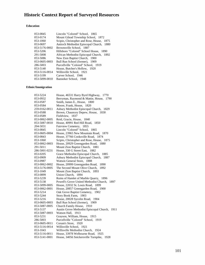
Historic Context Report of Surveyed Resources
101
Education
053-0845 Lincoln "Colored" School, 1865
053-0174 Mount Gilead Township School, 1872
053-1060 Scipio, Christopher and Rose, House, 1875
053-0697 Antioch Methodist Episcopal Church, 1880
053-5176-0002 Brownsville School, 1887
053-5206 Hillsboro "Colored" School House, 1890
291-5008 African Methodist Episcopal Church, 1892
053-5086 New Zion Baptist Church, 1900
053-0605-0003 Bull Run School (former), 1909
286-5003 Purcellville "Colored" School, 1919
053-5140 House, Butcher's Hollow, 1920
053-5116-0014 Willisville School, 1921
053-5199 Carver School, 1946
053-5099-0010 Banneker School, 1948
Ethnic/Immigration
053-5224 House, 46531 Harry Byrd Highway, 1770
053-0932 Berryman, Raymond & Mattie, House, 1790
053-0587 Smith, James E., House, 1800
053-0584 Moore, Frank, House, 1820
259-0162-0011 Asbury Methodist Episcopal Church, 1829
053-0588 Brown, Chauncey Depew, House, 1830
053-0589 Fieldview, 1837
053-0062-0005 Reid, Gracie, House, 1840
053-5087-0010 House, 40991 Red Hill Road, 1850
204-5031 Fairview Cemetery, 1855
053-0845 Lincoln "Colored" School, 1865
053-0605-0004 House, 23965 New Mountain Road, 1870
053-0843 House, 37766 Cooksville Road, 1874
053-1060 Scipio, Christopher and Rose, House, 1875
053-0062-0003 House, 20929 Greengarden Road, 1880
291-5011 Mount Zion Baptist Church, 1881
286-5001-0231 House, 330 G Street East, 1882
053-0205 Grace Methodist Episcopal Church, 1885
053-0909 Asbury Methodist Episcopal Church, 1887
053-0987 Watson General Store, 1888
053-0062-0002 House, 20999 Greengarden Road, 1890
053-5176-0005 The Second Mount Olive Church, 1892
053-1049 Mount Zion Baptist Church, 1893
053-0899 Union Church, 1894
053-5239 Ruins of Hamlet of Marble Quarry, 1896
053-5138 Powell's Grove United Methodist Church, 1897
053-5099-0005 House, 22032 St. Louis Road, 1899
053-0062-0001 House, 20857 Greengarden Road, 1900
053-5214 Oak Grove Baptist Cemetery, 1902
053-5244 Story Book Farm, 1903
053-5216 House, 20028 Sycolin Road, 1904
053-0605-0003 Bull Run School (former), 1909
053-5087-0005 Church Family House, 1910
053-5137 Austin Grove Methodist Episcopal Church, 1911
053-5087-0003 Watson Hall, 1913
053-5231 Grayson, William, House, 1915
286-5003 Purcellville "Colored" School, 1919
053-0605-0011 Corum's Store, 1920
053-5116-0014 Willisville School, 1921
053-1043 Willisville Methodist Church, 1924
053-5116-0011 House, 33978 Welbourne Road, 1925
053-5141-0001 House, 34056 Snickersville Turnpike, 1928

Historic Context Report of Surveyed Resources
102
053-5099-0016 Basil, Charles and Armeata, House, 1930
053-5099-0013 House, 22249 St. Louis Road, 1931
053-5141-0008 House, 34117 Snickersville Turnpike, 1932
291-5005 House, 5 Cedar Street, 1933
053-5198 Rowe, George, House, 1935
053-5154 House, 37632 John Mosby Highway, 1939
053-0605-0002 House, 24029 New Mountain Road, 1940
053-5210 House, 105 Hall Road, 1944
053-5087-0001 House, 22610 Watson Road, 1945
053-5199 Carver School, 1946
053-5099-0010 Banneker School, 1948
053-0605-0012 House, 24108 New Mountain Road, 1949
053-5228 House, 26014 Elk Lick Road, 1950
053-5169 House, 24134 Stewart Town Lane, 1954
053-5099-0007 Grant, M. Louise, House, 1955
053-5116-0007 House, 34007 Welbourne Road, 1956
053-5087-0009 First Baptist Church, 1957
053-5099-0001 House, 22209 McQuay Heights Lane, 1962
Funerary
053-0322 Mount Pleasant Baptist Church and Cemetery, 1880
053-0909 Asbury Methodist Episcopal Church, 1887
053-5218 Gleedsville Cemetery, 1893
053-5214 Oak Grove Baptist Cemetery, 1902
053-5116-0014 Willisville School, 1921
053-5087-0009 First Baptist Church, 1957
Recreation/Arts
286-5001-0107 House, 331 G Street, 1870
053-5155 Hall's Park, 1940
Religion
259-0162-0011 Asbury Methodist Episcopal Church, 1829
053-0464 Hughesville Baptist Church, 1870
053-0322 Mount Pleasant Baptist Church and Cemetery, 1880
291-5011 Mount Zion Baptist Church, 1881
053-0205 Grace Methodist Episcopal Church, 1885
053-0909 Asbury Methodist Episcopal Church, 1887
053-0994 Unitarian Universalist Church of Loudoun, 1890
053-5176-0005 The Second Mount Olive Church, 1892
053-1049 Mount Zion Baptist Church, 1893
053-0899 Union Church/ First Baptist Church of Sycolin, 1894
053-5239 Ruins of Hamlet of Marble Quarry, 1896
053-5138 Powell's Grove United Methodist Church, 1897
053-5214 Oak Grove Baptist Cemetery, 1902
053-5137 Austin Grove Methodist Episcopal Church, 1911
053-5087-0003 Watson Hall, 1913
053-5141-0007 Bluemont First Baptist Church, 1920
053-1043 Willisville Methodist Church, 1924
053-5197 Mount Zion United Methodist Church, 1928
286-5001-0230 Grace Annex Church, 1949
053-5087-0009 First Baptist Church, 1957
Social
053-5087-0003 Watson Hall, 1913

Historic Context Report of Surveyed Resources
103
Subsistence/Agriculture
053-5224 House, 46531 Harry Byrd Highway, 1770
053-5139 Walsh Farm Slave Quarter, 1790
053-0988 Charles Riticor House, 1870
053-5087-0007 Thornton House, 1900
053-5087-0005 Church Family House, 1910
053-5223 Nokes House, 1913
Transportation/Communication
053-0584 Moore, Frank, House, 1820

104
Historic Period Report of Surveyed Resources
Colony to Nation (1750 to 1789)
053-5224 House, 46531 Harry Byrd Highway, 1770
Early National Period (1790-1830)
053-0584 Moore, Frank, House, 1820
053-0587 Smith, James E., House, 1800
053-0588 Brown, Chauncey Depew, House, 1830
053-0932 Berryman, Raymond & Mattie, House, 1790
053-0984 Stone Slave Quarters, 1800
053-1024 Napper Log House, 1820
053-5098 House, 40455 Quaterbranch, 1800
053-5139 Walsh Farm Slave Quarter, 1790
053-5141-0004 House, 34058 Snickersville Turnpike, 1830
053-932 Berryman, Raymond, House, 1790
Antebellum Period (1831 to 1860)
053-0062-0005 Reid, Gracie, House, 1840
053-0589 Fieldview, 1837
053-0605-0010 Bowman, Berkley, House, 1850
053-5087-0010 House, 40991 Red Hill Road, 1850
053-5099-0018 House, 33995 Welbourne Road, 1850
053-5116-0008 House, 34017 Welbourne Road, 1840
053-5141-0004 House, 34058 Snickersville Turnpike, 1830
053-5230 Hayman, Ocsar "Friday", House, 1850
053-6037 Vacant house, Berryman Lane, 1850
291-5007 Redman, Dorsey House, 1850
Reconstruction and Growth (1865 to 1916)
053-0062-0001 House, 20857 Greengarden Road, 1900
053-0062-0002 House, 20999 Greengarden Road, 1890
053-0062-0003 Vacant house, north of 20965 Greengarden Road, 1880
053-0062-0004 House, 20965 Greengarden Road, 1880
053-0062-0006 House, 20991 Greengarden Road, 1880
053-0174 Mount Gilead Township School, 1872
053-0205 Grace Methodist Episcopal Church, 1885
053-0322 Mount Pleasant Baptist Church, 1880
053-0464 Hughesville Baptist Church, 1870
053-0605-0003 Bull Run School (former), 1909
053-0605-0004 House, 23965 New Mountain Road, 1870
053-0605-0006 House, 24054 New Mountain Road, 1909
053-0605-0007 House, 24060 New Mountain Road, 1909
053-0605-0008 Bowman, Walter, House, 1890
053-0605-0009 House, 24126 Bowmantown Road, 1900
053-0605-0010 Bowman, Berkley, House, 1880
053-0697 Antioch Methodist Episcopal Church, 1880
053-0823 Bell, Harold House, 1890
053-0825 Lucas House, 1880
053-0843 House, 37766 Cooksville Road, 1874
053-0845 Lincoln "Colored" School, 1865
053-0899 Union Baptist Church, 1894
053-0909 Asbury Methodist Episcopal Church, 1887
053-0932 Berryman, Raymond & Mattie, House, 1790

Historic Period Report of Surveyed Resources
105
053-0987 Watson General Store, 1888
053-0988 Charles Riticor House, 1870
053-0994 Unitarian Universalist Church of Loudoun, 1890
053-1023 Mount Pleasant Baptist Church, 1887
053-1049 Mount Zion Baptist Church, 1893
053-1060 Scipio, Christopher and Rose, House, 1875
053-5086 New Zion Baptist Church, 1900
053-5087-0002 House, 22503 Watson Road, 1890
053-5087-0003 Watson Hall, 1913
053-5087-0004 House, 22579 Watson Road, 1890
053-5087-0005 Church Family House, 1910
053-5087-0007 Thornton House, 1900
053-5087-0008 House, 40852 Red Hill Road, 1910
053-5097 House, 25600 Elk Lick Road 1900
053-5099-0003 House, 22181 St. Louis Road, 1900
053-5099-0004 Jackson, Mary Jane, House, 1900
053-5099-0005 House, 22032 St. Louis Road, 1899
053-5099-0006 St. Louis School, 1870
053-5099-0008 Strickland, Dwight, House, 1910
053-5099-0009 Store, 35285 Snake Hill Road, 1890
053-5099-0011 Dower, Nikia Rae, House, 1870
053-5099-0012 Mattingly, Don E., Jr., House, 1910
053-5099-0014 House, 22256 Newlin Mill Road, 1890
053-5099-0015 Smith, Willie A. and Grace Jackson, House, 1890
053-5099-0017 House, 22326 St. Louis Road, 1900
053-5116-0001 House, 33911 Welbourne Road, 1880
053-5116-0002 Abandoned House, Welbourne Road, 1900
053-5116-0003 House, 33973 Welbourne Road, 1890
053-5116-0004 Abandoned House, between 33995 & 34001 Welbourne Road, 1900
053-5116-0005 House, west of 34001 Welbourne Road, 1900
053-5116-0009 Willisville Store, 1910
053-5116-0010 House, 34055 Welbourne Road, 1890
053-5116-0012 Rosalee Gaskin House, 1900
053-5137 Austin Grove Methodist Episcopal Church, 1911
053-5138 Powell's Grove United Methodist Church, 1897
053-5140 House, Butcher's Hollow, 1920
053-5141-0003 House, 34090 Snickersville Turnpike, 1900
053-5141-0005 House, 18526 Foggy Bottom Road, 1890
053-5141-0006 House, 34069 Snickersville Turnpike, 1890
053-5149 House, 23375 Sam Fred Road, 1900
053-5150 House, 23381 Sam Fred Road, 1910
053-5151 House, 23320 Forsythia Lane, 1880
053-5153 House, 37615 John Mosby Highway, 1900
053-5170 House, 24151 Stewart Town Lane, 1910
053-5171 House, 21 Berlin Pike, 1890
053-5172 Morgan, Molly House, 1880
053-5173 Lovettsville School, 1880
053-5174 House, 24 South Loudoun Street, 1900
053-5175 Mt. Sinai Free Baptist Cemetery and Church site, 1880
053-5176-0002 Brownsville School, 1887
053-5176-0003 House, 39335 East Colonial Highway, 1900
053-5176-0004 House, 39345 East Colonial Highway, 1920
053-5176-0005 The Second Mount Olive Church, 1892
053-5176-0006 House, 17429 Brownsville Lane, 1910
053-5176-0007 House, 17445 Brownsville Lane, 1910
053-5176-0008 House, 17471 Brownsville Lane, 1910
053-5183 Mount Zion Methodist Episcopal Church Parsonage, 1890
053-5184 Collins House, 1900
053-5186 Harvey, Fannie, House, 1890
053-5187 Johnson, Charley House, 1910
053-5188 Clark, Howard Willard House, 1910
053-5189 House, 102 Delaware Avenue, 1870

Historic Period Report of Surveyed Resources
106
053-5190 House, 258 Maryland Avenue, 1880
053-5191 Former store, west of 242 Maryland Avenue, 1900
053-5192 House, 242 Maryland Avenue, 1890
053-5193 House, 232 Maryland Avenue, 1900
053-5195 Fields, Mary Clark, House, 1900
053-5196 Gaskins, Clint, House, 1900
053-5200 House, 710 20th Street, 1910
053-5204 House, 15411 Asbury Church Road, 1880
053-5205 House, 15407 Ashbury Church Road, 1800
053-5206 Hillsboro "Colored" School House, 1890
053-5207 House, 15469 Ashbury Church Road, 1880
053-5208 House, 220 Oakgrove Road, 1910
053-5209 House, 102 Hall Road, 1900
053-5212 House, 102 Locust Lane, 1900
053-5213 House, 104 Dominion Lane, 1900
053-5214 Oak Grove Baptist Cemetery, 1902
053-5216 House, 20028 Sycolin Road, 1904
053-5217 House, 20100 Sycolin Road, 1900
053-5219 House, 20492 Gleedsville Road, 1900
053-5220 House, 20514 Gleedsville Road, 1900
053-5223 Nokes House, 1913
053-5225 Trammel, John House, 1900
053-5231 Grayson, William, House, 1915
053-5232 Webster, Frank, House, 1870
053-5233 House, 35771 Hayman Lane, 1900
053-5236 Campbell House, 1870
053-5238 House, 38062 Lime Kiln Road, 1880
053-5239 Ruins of Hamlet of Marble Quarry, 1896
053-5240 House, 21438 Steptoe Hill Road, 1870
053-5244 Story Book Farm, 1903
259-5060 House, 109 Windy Hill Road, 1900
259-5063 House, 111 Windy Hill Road, 1900
259-5066 House, 7 Windy Hill Road, 1900
259-5067 House, 5 Windy Hill Road, 1900
286-5001-0231 House, 330 G Street East, 1882
291-5001 Henderson, Jim, House, 1900
291-5002 House, 4 High Street, 1890
291-5003 House, 2 High Street, 1900
291-5004 House, 25 Main Street, 1900
291-5006 House, 13 Cedar Street, 1910
291-5008 African Methodist Episcopal Church, 1892
291-5009 Beaner, Nicolas House, 1890
291-5010 Clark, Rodney & Meada, House, 1890
291-5011 Mount Zion Baptist Church, 1881
291-5012 Clark Flave House, 1900
World War I to World War II (1917-1945)
053-0605-0005 House, 23985 New Mountain Road, 1940
053-0605-0011 Corum's Store, 1920
053-1043 Willisville Methodist Church, 1924
053-5087-0001 House, 22610 Watson Road, 1945
053-5087-0006 House, 40710 Red Hill Road, 1920
053-5099-0002 Trammell, Irene H., House, 1940
053-5099-0013 House, 22249 St. Louis Road, 1931
053-5099-0016 Basil, Charles and Armeata, House, 1930
053-5116-0006 House, 34001 Welbourne Road, 1920
053-5116-0011 House, 33978 Welbourne Road, 1925
053-5116-0013 House, 33960 Welbourne Road, 1920
053-5116-0014 Willisville School, 1921
053-5141-0001 House, 34056 Snickersville Turnpike, 1928
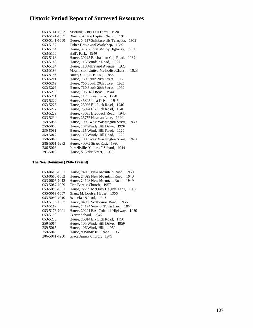
Historic Period Report of Surveyed Resources
107
053-5141-0002 Morning Glory Hill Farm, 1920
053-5141-0007 Bluemont First Baptist Church, 1920
053-5141-0008 House, 34117 Snickersville Turnpike, 1932
053-5152 Fisher House and Workshop, 1930
053-5154 House, 37632 John Mosby Highway, 1939
053-5155 Hall's Park, 1940
053-5168 House, 39245 Buchannon Gap Road, 1930
053-5185 House, 115 Ivandale Road, 1920
053-5194 House, 118 Maryland Avenue, 1920
053-5197 Mount Zion United Methodist Church, 1928
053-5198 Rowe, George, House, 1935
053-5201 House, 730 South 20th Street, 1935
053-5202 House, 750 South 20th Street, 1920
053-5203 House, 760 South 20th Street, 1930
053-5210 House, 105 Hall Road, 1944
053-5211 House, 112 Locust Lane, 1920
053-5222 House, 45805 Jona Drive, 1945
053-5226 House, 25926 Elk Lick Road, 1940
053-5227 House, 25974 Elk Lick Road, 1940
053-5229 House, 43035 Braddock Road, 1940
053-5234 House, 35757 Hayman Lane, 1940
259-5058 House, 1000 West Washington Street, 1930
259-5059 House, 107 Windy Hill Drive, 1920
259-5061 House, 115 Windy Hill Road, 1920
259-5062 House, 113 Windy Hill Road, 1920
259-5068 House, 1006 West Washington Street, 1940
286-5001-0232 House, 400 G Street East, 1920
286-5003 Purcellville "Colored" School, 1919
291-5005 House, 5 Cedar Street, 1933
The New Dominion (1946- Present)
053-0605-0001 House, 24035 New Mountain Road, 1959
053-0605-0002 House, 24029 New Mountain Road, 1940
053-0605-0012 House, 24108 New Mountain Road, 1949
053-5087-0009 First Baptist Church, 1957
053-5099-0001 House, 22209 McQuay Heights Lane, 1962
053-5099-0007 Grant, M. Louise, House, 1955
053-5099-0010 Banneker School, 1948
053-5116-0007 House, 34007 Welbourne Road, 1956
053-5169 House, 24134 Stewart Town Lane, 1954
053-5176-0001 House, 39291 East Colonial Highway, 1920
053-5199 Carver School, 1946
053-5228 House, 26014 Elk Lick Road, 1950
259-5064 House, 105 Windy Hill Drive, 1950
259-5065 House, 106 Windy Hill, 1950
259-5069 House, 9 Windy Hill Road, 1950
286-5001-0230 Grace Annex Church, 1949

108
APPENDIX B: Brief Histories of Surveyed Towns, Villages, Hamlets, and
Neighborhoods

109
African-American Towns, Villages, Hamlets, and Neighborhoods
In Loudoun County, Virginia * Denotes towns that were chosen to be documented with Virginia Department of Historic
Resources Preliminary Information Forms
Berryman
Berryman was settled by African Americans in the 19th century. The community included a
school, known as the second Marble Quarry School, and several residences. In 1973, the
congregation of Mount Zion Baptist Church of Marble Quarry purchased the former school
building and converted it into their church.43
Bowmantown*
Bowmantown is a historically African-American village located approximately one mile south of
Route 50 near Aldie. Settled prior to the Civil War, early residents included members of the
Bowman and Napper families. In the 1870s, the community organized the Mount Pleasant
Baptist Church of Bowmantown, and by 1909, it had a schoolhouse where local black children
were educated. The school operated until 1958 or 1959.
Oral tradition suggests that Frank Napper, a freed slave, came to this area from Alexandria,
Virginia shortly before the Civil War. His son James Garfield Napper was born in 1879 and
continued to live in the area, occupying this log house on Buchannon Gap Road. James Napper
was a longtime Bowmantown resident and member of the Mount Pleasant Baptist Church. He
lived to be over 100 years old.44
Britain/New Guinea
The area known locally as Britain or New Guinea, encompassed the former church, a store, and a
handful of houses along Mountain Road (Route 690) south of the intersection with Route 682
and was originally settled in the 1730s by families of German ancestry. African-Americans
moved to the area after Emancipation. The original African-American families who lived in the
43
Notes taken by Deborah Lee, student in Eugene Scheel's class on African American History, notes on visit to
Marble Quarry, April 2, 2001; Loudoun County's African American Communities, Exhibit Text, 2001 [Exhibit on
display at Thomas Balch Library, Leesburg, Virginia]; Loudoun Museum, "Courage, My Soul: Historic African
American Churches and Mutual Aid Societies," An exhibition at the Loudoun Museum, February 13 - April 30,
2000. 44
Eugene Scheel, "Bowman reflects black history," Loudoun Times-Mirror, 16 January 1991; Scheel,
―Bowmantown, Loudoun’s First Black Settlement,‖ Loudoun Times-Mirror, 10 June 1976; Maura McKenney, ―An
Oral History of Life in Bowman Town Aldie, VA: As Told by Mr. Norman Stewart, age 89,‖ Unpublished oral
history paper, November 7, 2001; Dodi Turney and Maura McKenney, ―Bull Run School: The ―Lost‖ School of
Bowman Town,‖ Unpublished historical archaeology paper, 2001; ―105th
Anniversary: Mt. Pleasant Baptist
Church, Aldie, Virginia,‖ Church history published under Reverend William D. Jackson, Pastor, 1980.

110
Britain or Guinea area included the Curtises, the Hogans, the Parises, the Motens, the Stones, and
the Timbers.45
Brown’s Corner
Located approximately one-quarter mile east of Middleburg, the hamlet known locally as
―Brown’s Corner‖ or ―Maryland‖ consists of a cluster of five historic dwellings located at the
intersection of John Mosby Highway (Route 50, formerly the Ashby’s Gap Turnpike) and Sam
Fred Road (Route 748, formerly McCarty’s Mill Road). Two of the houses are substantial stone
buildings constructed prior to the Civil War. Local tradition holds that the community acquired
its name from Edwin Conway Broun (sometimes spelled ―Brown‖) who acquired a tract of land
north of the corner in 1855. Reputedly, two of Broun’s slaves, Joseph Brown and Sarah Moten
who were freed in 1863 and married circa 1870, lived in one of the two antebellum houses at
Brown’s Corner. They may be the origin of the name Brown’s Corner, which since the late 19th
century, has been associated with two prominent African-American families, the Halls and the
Browns.46
Brownsville/Swampoodle*
Located approximately one-half mile east of Hamilton on East Colonial Highway (Business
Route 7), the village of Brownsville, also known as Swampoodle, developed around a
schoolhouse and a church that served the local African-American community. Local tradition
states that the name Swampoodle came from for the low-lying ground along the main road
Leesburg Turnpike that got swamped with puddles when it rained. During the late 19th and
early 20th century, a small residential community grew up clustered around the circa-1887
Brownsville School and the 1892 Second Mount Olive Baptist Church. Brownsville is one of a
number of predominantly African-American settlements that were established after the Civil War
and before the turn of the 20th century in Loudoun County. These tight-knit communities
provided support and opportunities to African Americans after emancipation.47
Butcher’s Hollow (Bluemont vicinity)
Following the Civil War a small group of former slaves created a community outside the town of
Bluemont (formerly Snickersville) in western Loudoun County. The community had no official
name, but has sometimes been called Butcher’s Hollow, presumably for its location near the
headwaters of Butcher’s Branch. The remnants of the hamlet, a stone house and the stone
45
Scheel, ―Downtown Britain, A German Settlement,‖ Loudoun Times-Mirror, 1976; Elaine, E. Thompson,
Courage My Soul: Historic African American Churches and Mutual Aid Societies (Leesburg, Virginia: Loudoun
Museum, 2000), p. 26. 46
Scheel, ―Brown’s Corner: A 4-House Huddle,‖ Loudoun Times-Mirror, 22 July 1978. 47
Scheel, ―Double Names, Long History,‖ Loudoun Times-Mirror, Date unknown; Scheel, The Guide to Loudoun
County: A Survey of the Architecture and History of a Virginia County (Leesburg, VA: Potomac Press, 1975); ―The
Second Mt. Olive Baptist Church: Where Sound Doctrine is Amplified,‖ Church Literature, No date, Available at
the Thomas Balch Library, Leesburg, Virginia.

111
foundation of a former schoolhouse, stand south of Bluemont proper and on the eastern slope of
the Blue Ridge Mountains. Benjamin Franklin Young was one of the early landowners in
Butcher’s Hollow. In 1871, he purchased 17 acres from his mentor, Dr. George Emory Plaster, a
local white doctor who reputedly mentored Young. In the 1870 census, Young was listed as a
40-year-old mulatto male laborer living with Dr. Plaster, however his name was recorded as Dr.
Frank Young. It’s likely that he served as Dr. Plaster’s assistant and apprentice.
Prior to the Civil War, the area around Bluemont housed several free African Americans. Some,
like farmer and tanner Aldred Fox and laborer James Fields, owned real estate. Bluemont
historian Jean Herron Smith indicates that Fields purchased land in the Butcher’s Hollow vicinity
prior to the war.48
However, the community began to develop after Young subdivided and sold
off parcels of his land to other African Americans.
In 1888, community members established the First Baptist Church and the following year built a
schoolhouse to educate African-American children. Until 1929, when they built their own
church, the First Baptist congregation worshipped in the schoolhouse. According to local
historian Eugene Scheel, the residents of Butcher’s Hollow maintained small subsistence farms
on their land and traveled into Bluemont to work as laborers or in service jobs. During the 1930s
and 1940s as the residents of Butcher’s Hollow aged, many moved away to more convenient
locations. In 1949, the First Baptist Church’s congregation dismantled the1929 church building
and moved it to a new lot on the south side of Snickersville Turnpike just east of Bluemont
where it still serves the congregation. The remnants of the Butcher’s Hollow community stand
as the last vestiges of a post-Civil War African-American community, one of a number of
predominantly African-American settlements that were established after the Civil War and
before the turn of the 20th century in Loudoun County.49
Conklin
Conklin was a bi-racial community that developed into a small hamlet during the latter half of
the 19th
century. Centered on Braddock Road (Route 620, formerly the Colchester Road), this
rural community stretched from Gum Springs Road (Route 659) on the west, to Bull Run Post
Office Road (Route 621) on the east. The area was settled around 1810 by Reuben Settle, Jr.
who purchased a total of 142 acres along Braddock Road (formerly the Colchester Road)
between 1810 and 1812. By 1853, Thomas and Nelson Settle, presumably Reuben’s heirs, were
living in a house on the north side of Braddock Road, just west of its intersection with Elk Lick
Road. Other local white landowners at that time included the Hutchinson, James, and Saffer
families.
The Settles owned at least three slaves prior to the Civil War. Following the war, they employed
three black workers, all members of the Dean family, who lived in their household. In 1886 and
48
Jean Herron Smith, Snickersville: The Biography of a Village (Miamisburg, Ohio: Miamisburg News, 1970; 2nd
ed. Bluemont, VA: Robert W. Hoffman, 2000), pp. 56, 76. 49
Deborah Lee, ―Community History and Mapping Project: Black History Committee, Friends of the Thomas
Balch Library;‖ Notes from Eugene Scheel’s African American History in Loudoun County class, April 23, 2001;
Scheel, ―Father and Son Treated a Century of Ills,‖ Washington Post, Loudoun Extra, 25 March 2001.

112
1889, Thomas and Nelson Settle willed their estate to Charles W. Dean, the brother of one of
their post-war domestic servants. Nelson’s will stated that Charles Dean was ―the son of my old
servant Martha Dean,‖ and that his bequest was offered ―as a reward to the said Charles Dean for
special services rendered me in my declining years in faithfully serving me and taking care of my
interests for a number of years‖ (Loudoun County Will Book I:466,478). In fact, the Settles had
land dealings with the Dean family well before their deaths. In 1874, Thomas Settle sold
Charles’ father, Reuben Dean, 53 acres of land on Elk Lick Run.
Research conducted by genealogist Marty Hiatt has determined that Charles Dean and Jennie S.
Dean, the renowned African-American educator and founder of the Manassas Industrial School
in neighboring Prince William County, were not, as suggested by earlier research, brother and
sister, but may have been cousins. Whatever their relationship, it is clear that the Conklin Deans
were connected to Jennie Dean who lived in Prince William County. They were active in her
educational and religious activities. Charles Dean’s sister, Fanny Dean Douglas, headed the
local fundraising committee that collected funds to support the establishment of the Manassas
Industrial School, which was opened in 1893. In 1897, Charles Dean granted an acre of land at
the northwest corner of Braddock Road and Elk Lick Road to the trustees of Prosperity Baptist
Church upon which to erect a church. Jennie Dean’s sister Ella Dean Bailey was married to
Reverend Lewis Henry Bailey who is credited with being one of Prosperity Church’s original
founders. A Dean biographer also suggests that she provided support for the founding of the
church in 1899.
Other Conklin area slaveholders gave or sold land to African Americans after the Civil War.
Among these was Benjamin Frank Saffer who died in 1903 and left his house and property to
Frank Denny, a ―colored boy‖ that he had raised. According to local historian Arlean Hill,
Saffer’s executors, who were members of the Hutchinson family, never informed Denny that he
had inherited the property and subsequently seized the house and lot, claiming that the heir could
not be found.
The hamlet of Conklin was named after a white family, Joseph R. and Mary Conklin, who
purchased land in the area in 1871. That year, local landowner Horace Adee sold a parcel of
land to the Broad Run School District for the construction of a school for African-American
children. Located off of what is now Ticonderoga Road (Route 613, formerly Fairview Church
Road), the one-room frame schoolhouse was finished the following year and served the
community well into the 1940s. There was also a one-room school for white children, the
McGraw’s Ridge School, which was built in 1889 on Gum Springs Road south of Braddock
Road (Route 620). In 1890, a store and post office were established in Conklin at the corner of
Braddock Road and Ticonderoga Road.
The first church to be built in the community was Fairview Methodist Episcopal Church that
housed a white congregation. They built the church on a lot at the intersection of Ticonderoga
Road and Gum Springs Road. In 1899, on land donated by Charles Dean, African-American
residents of Conklin erected Prosperity Baptist Church on a one-acre lot at the northwest corner
of Braddock Road and Elk Lick Road.

113
In the 1930s, Fairview Church closed; in 1939, the McGraw Ridge School shut its doors. In
1951, a fire destroyed Prosperity Baptist Church. After the fire, the congregation collected
enough money to start reconstruction. They completed building a new foundation and basement,
however, the main first floor sanctuary would not be rebuilt until 1972. Sometime prior to 1955,
the African-American Conklin School was closed and the school building was sold and
converted into a residence.
Today, Conklin is threatened by the encroachment of a large suburban style subdivision to its
north and by the construction of a multi-lane parkway running north to south through its center.
In recent years, local historians, including Wynne Saffer and Arlean Hill, have conducted
historical research and oral histories to collect the history of the Conklin community. Loudoun
County has required the developers of the subdivision to document the architectural and
archaeological evidence of the log house and farmstead known as the Settle-Dean property on
Braddock Road (053-5064 and 44LD773). The Settle-Dean log house (053-5064) has since been
moved from its original location to a new site approximately 1000 feet to the west on the west
side of the new Loudoun County Parkway right-of-way. The house will be accessible by a
walking trail and will be interpreted with signage.50
Dover
The hamlet of Dover is named for the Hixson family who settled here in the 18th century and
named their homeplace ―Dover‖ after their ancestral home of Dover, England. During the early
19th century, the Hixsons built Dover Mills which operated as a flour and sawmill until the Civil
War. Frank Moore, a former slave, purchased the stone tollhouse on the north side of Route 50,
and his descendants still own the property. The building is remarkably unchanged on the
exterior although portions are deteriorating.51
Gleedsville
The name Gleedsville first appeared in Loudoun County land records in 1889 when local
African-American landowner John ―Jack‖ Gleed sold an acre and a half lot to Murray Allen. A
community of African Americans, (possibly from George Carter’s Oatlands plantation), predates
this by at least twenty years. Circa 1870, J. Gleed’s name appears on a map of the magisterial
50
Marty Hiatt, ―Research Report on Dean and Settle families of Conklin, prepared for Angel David Nieve,
Department of Architecture, Cornell University, Ithaca, NY,‖ December 27, 1998 and January 22, 1999. Scheel,
―Joseph Conklin Left Name to Area,‖ Loudoun Times-Mirror, 23 September 1976, Section B. Stephen Johnson
Lewis, Undaunted Faith…The Life Story of Jennie Dean (Manassas, VA: Manassas Museum, 1994, reprinted from
the original 1942 edition). Cultural Resources, Inc., ―Phase I Architectural and Archaeological Investigation of the
Settle-Dean Farmstead, 44LD773/053-5064, South Riding Development, Loudoun County, Virginia,‖ July 2001.
Cultural Resources, Inc., ―Phase II Archaeological Investigation of the Settle-Dean Farmstead Site (44LD773),
Loudoun County, Virginia.‖ September 2001; ―Conklin‖ vertical file at Thomas Balch Library, Leesburg, Virginia;
Jennifer Lenhart, ―History By Word of Mouth,‖ Washington Post, 9 November 2000, Loudoun Extra section, pp. 1,
8. 51
Scheel, ―Dover was Named for an English Village; Old Mill gave Stones to Middleburg Bank,‖ Loudoun Times-
Mirror, 4 November 1976.

114
district. The 1870 census indicates that John Gleed, a 40-year-old, black male, owned $250-
worth of real estate. By the late 19th century, Gleedsville had a school known as the ―Mountain
Gap Colored School‖ (circa 1887), a church, Mt. Olive United Methodist Church (built in
1890), and a grocery store run by the Daniel family (white landowners who sold the land for the
African-American school). The school operated into the 1940s and the church congregation
remained until its merger with the Mt. Zion United Methodist Church in Leesburg in the mid-
1980s.52
Hamilton
From an early date, Hamilton has had a significant African-American population. Following the
Civil War, the federal Freedmen’s Bureau established a school for African-American children
near Hamilton (location unknown). By 1870, the school had an enrollment of 64 students, 36 of
whom were over the age of 16 (Freedmen Bureau files, National Archives, full cite?). In 1878,
in order to support African-American residents who were often denied access by local whites to
instruments of insurance, bank loans, and lines of credit, several of Hamilton’s residents formed
one of the town’s two mutual aid societies. The first of these was the Golden Hill Lodge #1890
of the Grand United Order of Odd Fellows. Known as the Order of Galilean Fishermen, the
second mutual aid society in Hamilton began prior to 1890. The Galilean Fishermen owned a
building on West Virginia Avenue that is no longer standing.
Mount Zion Methodist Episcopal Church formed in 1880. Its 1928, stuccoed frame church
building still serves the congregation at 250 West Virginia Avenue (VDHR I.D. No. 053-5197).)
In 1890, the Loudoun County Emancipation Association was founded in Hamilton by a group of
Loudoun’s African-American citizens. Although the group later purchased land and moved its
headquarters to Purcellville in 1910, many residents of Hamilton and the nearby community of
Brownsville continued to be active in the organization.53
Because white citizens typically did not permit African-American citizens to purchase land in the
white neighborhoods of Loudoun’s towns, a racially segregated African-American neighborhood
developed in Hamilton along West Virginia, Maryland, and Delaware Avenues between Ivandale
and North Laycock roads to the north of the incorporated town. Composed of 15-20 buildings,
this community included several vernacular I-houses that were built between 1880 and circa
1920.
Hillsboro – See Short Hill.
52
Scheel, ―Gleedsville Named After Ex-Slave,‖ Loudoun Times-Mirror, 7 April 1977. 53
History Matters, ―Hamilton PIF,‖ 2003. Elaine E. Thompson, Courage My Soul: Historic African American
Churches and Mutual Aid Societies (Leesburg, VA: Loudoun Museum, 2000), pp. 35-44.

115
Howardsville*
A group of former slaves reputedly settled the community of Howardsville after the Civil War.
On December 12, 1874, Jacob ―Jack‖ Howard (born 1832) and Andrew Cosberry, along with
Jerry (Jeremiah) Basil purchased the first two lots in what would become the village of
Howardsville. In 1870, Jack and Sophia Howard and their three children lived in the household
of wealthy white landowner Elizabeth Carter. Four years later, the Howard family co-owned a
four-acre lot that originally had been a part of the Grayson family’s Newstead farm southwest of
Bloomfield in Loudoun County. In 1861, William and Mary Stephenson purchased a 28-acre
section of Newstead, known as the ―Burnt house wood lot.‖ It was this parcel that was divided
up and sold to the first three families to settle Howardsville, the Howards, the Basils, and the
Summers.
In 1874, Jerry Basil purchased a 2-acre lot for $50 from the Stephensons. Two years later,
Armistead Summers paid $45 for a 1-acre lot on Greengarden Road (Route 719). In 1879, the
Stephensons sold two more tracts in the fledgling community of Howardsville, one 2-acre lot to
Frank, Walker, Elizabeth, Eli, and Clinton Summers for $85 and another 1-acre tract to Jacob
Colbert for $50.
Most of Howardsville’s early residents maintained small farms and some supplemented their
incomes by working the fields of nearby farms or working as domestic servants in the
households of wealthier Loudoun residents. By 1900, there were at least eight black families in
the Howardsville vicinity who owned and worked their own farms. One area resident, James
Valentine, was a huckster or peddler of various wares.
Oral tradition records that Howardsville’s early residents also were the stonemasons who built
the dry-laid stone walls that separated the fields across Loudoun’s western section. Other
residents produced baskets and brooms using materials grown on their farms. According to Reid
family members, their family came to Howardsville in the 1920s. Clarence Reid worked as a
horse trainer on a private estate near Upperville in Fauquier County. Other Howardsville men
worked in the stables or at the training track near Middleburg.54
Unlike other Loudoun County African-American communities, Howardsville never built its own
school or church. Instead, residents attended school and church in nearby Rock Hill (see Austin
Grove Methodist Episcopal Church, 053-5137).
By 1930, there were eight dwellings in Howardsville that ranged in value from $200 to $2000.
Forty-nine people lived in these eight households. Seven of eight families owned their house.
At that time, the village’s residents included several chambermaids and farm laborers, a horse
trainer, a stonemason, and a chauffeur.55
54
Victoria Benning, ―A Shrinking Future for a Place in History: Loudoun Hamlet Nears Last Chapter,‖ The
Washington Post 15 December 1996; Eileen M. Carlton, ―Howardsville,‖ Loudoun Times-Mirror 10 July 1996.
Scheel, ―Howardsville, A Black Community in Loudoun,‖ Loudoun Times-Mirror 10 July 1996. 55
1930 United States Census, Loudoun County, Virginia.

116
Hughesville
The former Mt. Gilead Township School was originally built to serve white students, however,
some evidence suggests that it may have, at one time, been used as an African-American school.
A 1923 map and a 1935 map of Loudoun County suggests that during these years, Hughesville
had only one educational institution, a ―colored‖ school that was situated very near the location
of this school. This suggests that, by the 1920s, the white school had closed, and possibly was
being used as the Hughesville African-American school. However, a 1940 survey of the
county’s school buildings contradicts this evidence. The 1940 survey includes a photograph of
the Hughesville ―Colored‖ School in a different building. While very similar in appearance, the
school shown in the 1940 photograph is not the same as the present building. Judging from the
existing maps, the location of this African-American schoolhouse must have been very close to
the former white school.56
Lincoln
The village of Lincoln originated in the mid-18th century as the site of the Goose Creek Meeting
House of the Society of Friends; the second oldest Quaker meetinghouse in Virginia. Lincoln
has always had a significant African-American population. In 1815, Lincoln area Quakers
opened a private school that was open to both black and white students. After emancipation,
Lincoln acquired one of the first African-American public schools in Loudoun County.
Supported by the Society of Friends, the 1865 schoolhouse still stands on Cooksville Road (053-
0845).
In the late 19th
century, two African-American religious congregation formed in Lincoln. Grace
Methodist Episcopal Church was founded circa 1872 under the leadership of Rev. Henry Carroll.
Services were originally held in the village’s African-American schoolhouse (see 053-0845). In
December 1884, the church trustees, Oscar Carry, Jesse Palmer, George Parker, John Lewis, and
James R. Hicks purchased a half-acre lot in Lincoln from Mary E. Birdsall (Loudoun County
Deed Book 6-W, p. 483). The cornerstone of the present stone church was laid on July 30, 1885.
Early members of the church came from the Thomas, Cooper, Brady, Lewis, Carey, Gordon,
Dade, Simms, Bell, Furr, Moore, Coates, Hicks, Henderson, Cook, and Mitchell families. The
basement of the present church building was used for vocational classes that included shoe
repair, sewing, and cooking. The Quaker community in Lincoln sponsored the vocational
classes.
The church continued to serve Lincoln’s African-American community until 1942, when, due to
dwindling membership, the congregation moved to Purcellville. Special events continued to be
56
Oscar L. Emerick, Superintendent of Schools, Loudoun County, Virginia, 1923; Commonwealth of Virginia.
Department of Highways, Division of Surveys and Plans, Map of Loudoun County Showing Primary and Secondary
Highways (Richmond, Virginia, 1932); Thomas E. Sims, Jr., ―Inspection and Survey Report,‖ This is an evaluation
and description of Loudoun County schools prepared in 1940 by a special agent of the Garrett Insurance Agency of
Leesburg, Virginia. The evaluations are available in the ―Public Schools‖ vertical file at the Thomas Balch Library
in Leesburg, Virginia.

117
held at the old stone church until 1951 when the new Grace Annex church was opened in
Purcellville (see 053-1037-0230).
The old stone church stands at the end of Brooks Lane in an area historically associated with
African Americans. The still active Mount Olive Baptist Church (see 053-0175) stands directly
south of the now vacant Grace Methodist Episcopal Church. The two churches may have shared
the existing cemetery that stands between them.57
Lovettsville
Prior to 1868, the African-American residents of Lovettsville and the surrounding area organized
a Methodist Episcopal congregation. On August 11, 1868, the church trustees purchased a lot at
the northwestern end of the town where Broad Way intersected with the Berlin Turnpike.
Around 1875, the lot was labeled on a town plat as the ―African Chapel‖ lot. The circa-1900,
one-story, front-gable building that occupies the site today may have replaced an earlier
structure. The building served both as a chapel and as a school building for African-American
children in the community. The site also contains a cemetery with marked graves dating back to
1890. After the school was closed, the building served as the meeting place of the Lovettsville
Home Demonstration Club.58
Lucketts Area
In 1880, Reverend Charles Hadley and one dozen African-American residents in the Lucketts
vicinity organized the Mount Pleasant Baptist Church. Local builder, Jewel Frye built the church
on land donated by Martha Ambers Thomas. An addition to the church was constructed in 1915
during the longtime pastorate of Rev. R.L. Nickens.59
Macsville
According to local tradition, Macsville was named after the white McVeigh family that settled in
Loudoun County in 1793. The name apparently referred to the group of slave quarters,
outbuildings, and warehouses owned by the McVeighs that once stood along the former Ashby’s
Gap Turnpike, now Route 50 (John Mosby Highway). The small hamlet has continued to be
populated by African-American families.60
In 1930, Clarendon C. Fisher ran his own
57
―Forty-Second Anniversary: Grace Annex United Methodist Church,‖ Purcellville, VA, 1993; ―Historic Facts on
Grace Church,‖ circa 1985, Available at the Thomas Balch Library in Leesburg, VA; ―Mortgage Burning and
Church Dedication of the Grace Annex Methodist Church: West Baltimore District, Washington Conference,
Purcellville, Va.,‖ April 30, 1961. 58
Yetive Rockefeller Weatherly, Lovettsville: The German Settlement (Lovettsville, VA: The Lovettsville
Bicentennial Committee, [n.d. 1976?]), p.102. 59
Elaine, E. Thompson, Courage My Soul: Historic African American Churches and Mutual Aid Societies
(Leesburg, Virginia: Loudoun Museum, 2000), p. 25; ―Mt. Pleasant Baptist Church, Lucketts, Virginia: 105 Years
of Service to God and Man,‖ 1985, Available at the Thomas Balch Library, Leesburg, Virginia. 60
Scheel, ―A Straggle of Houses called Macsville,‖ Loudoun Times-Mirror July 13, 1978.

118
shoemaker’s shop in a freestanding workshop that still stands in Macsville (053-5152). Another
local landmark is Hall’s Park. Located just north of the hamlet, the park is associated with the
Halls, a prominent African-American family in Loudoun County. During the height of
segregation in the early to mid-20th century, the field that fronts the former Hall residence
(23171 Carters Farm Lane, 053-5155) hosted many recreational activities for African Americans.
Horse races, baseball games, and festivals were held there, and Middleburg’s black baseball team
was among the sports teams that played there in the mid-20th century.
Marble Quarry:
In 1875, the Virginia Marble Company began quarrying marble on the land of Benjamin F.
Carter east of the village of Mountville. Carter sold 400 acres to the Virginia Marble Company
for the purposes of opening a quarry and laying off a town or village. In anticipation of a
workforce of about 50 families, mostly former African-American slaves, the Mercer School
District purchased a quarter-acre of land in the vicinity of the quarry and built a frame
schoolhouse. In 1896, the growing community known informally as Marble Quarry erected Zion
Baptist Church. In 1949, operations at the quarry ceased. In the early 1950s, the church and the
school were forced to move because of the lack of good water. During its operation, the quarry
produced marble that was awarded medals at the Columbian Exposition in Chicago in 1900 and
at the Jamestown Exposition in 1907. Marble from the Virginia Marble Company was in
terrazzo flooring in public and commercial buildings in Washington, DC, New York and
Boston..61
Murphy’s Corner*
Murphy’s Corner contains buildings that were built in the late 1800s to the 1950s. The area
appears to have been settled in the 1870s by African Americans who had been enslaved by local
white residents. Through the mid-20th
century, the hamlet continued to grow as a segregated
African-American community outside of the town of Bluemont. In 1949, the congregation of
First Baptist Church, whose sanctuary stood on the mountain southwest of Bluemont along
Butcher’s Branch, decided to move the church building to Murphy’s Corner where it would be
more accessible to its members. The name of the hamlet likely derives from James F. Murphy, a
white harness maker who lived in the area.62
Among the landmarks in Murphy’s Corner is the Beatrice Scipio House, a log dwelling that dates
to circa 1870. It was reputedly built by Christopher Scipio who, according to a local historian,
was born into slavery in 1851 as the property of Craven James. Scipio married Rose L. Jackson
in 1874 in Loudoun County and according to local informants, built this log dwelling shortly
61
Scheel, ―Marble Quarry Began with a Grist Mill,‖ Loudoun Times-Mirror, 21 July 1970. 62
Deborah Lee, ―Community History and Mapping Project: Black History Committee, Friends of the Thomas Balch
Library;‖ Notes from Eugene Scheel’s African American History in Loudoun County class, April 23, 2001; Elaine,
E. Thompson, Courage My Soul: Historic African American Churches and Mutual Aid Societies (Leesburg,
Virginia: Loudoun Museum, 2000), p. 28; Scheel, ―Three Voices from the Past, Remembered in Words and Deed,‖
The Washington Post February 25, 2001.

119
thereafter. One of Christopher and Rose’s children was Beatrice Scipio (1892-1978) who earned
a teaching degree from Storer College in Harper’s Ferry, West Virginia in 1910. Shortly
thereafter she began a 46-year teaching career, during which she taught at the Bluemont
―Colored‖ School on the mountain near Butcher’s Branch until it closed in 1933. Later she
taught at the George Washington Carver School in Purcellville where she ended her teaching
career in 1957. Scipio was well respected in her community and frequently taught children in
her home.
Nokesville
The area known locally as Nokes or Nokesville derived its name from former slave, George
Washington Nokes who leased land in the area from the Blincoe family after the Civil War. In
1901, Nokes purchased five acres on the south side of Thayer Road. The area became home to
several African-American families, a few of which owned large tracts of land. The Edes family
and the Ewing family both owned farms over 200 acres in size. The Edes property was located
near where Countryside Boulevard now intersects with Harry Byrd Highway (Route 7) in
Sterling. The Edes ran a dairy farm operation there and shipped milk to Washington, DC. The
Ewing farm stood southeast of there near where Harry Byrd Highway intersects with Cascades
Parkway. A school for black students once stood at the corner of what are now Cascades
Parkway and Nokes Boulevard. Opened circa 1917, the school served dual purposes, as a
classroom and as a community center. It appears on a 1923 Loudoun County school districts
map as the ―Nokes‖ school since the acre of land upon which it stood was donated by the Nokes
family, who also owned significant land in the vicinity. One of the Edes family residences and
the Nokes homestead still stand, albeit surrounded by suburban-style development of the 1960s
through the present.63
Oak Grove
Six historic residences that date from the turn of the 20th century through the mid-20th century
remain in the predominantly African-American community of Oak Grove. According to local
historian Eugene Scheel, newly freed slaves settled Oak Grove. They purchased land from
George W. and Cynthia Bell of Herndon who, in 1871, had purchased and subdivided the former
Payne farm into one-acre lots. The early settlers included the Berkley, Hannah, and Wormley
families. William Sheldon was the first to purchase a lot in Oak Grove in 1874. Local
informants described Oak Grove as a self-contained community that at one time had a segregated
public school, church, a small general store, and its own baseball league. The school still stands
in Herndon, Fairfax County and now houses the Herndon Police Department. Oak Grove once
had a flag stop on the Washington & Old Dominion Railroad.
In 1868, with the help of local resident Ellen Thompson, Reverend Robert Woodson, pastor of
Zion Baptist Church in Alexandria, Virginia founded Oak Grove Baptist Church near the Town
of Herndon. The first church was constructed of logs circa 1875 and served both as the church
and as a schoolhouse. The church purchased the one-acre lot from George W. and Cynthia Bell
63
Scheel, ―Lanesville: Site of Historic Post Office,‖ Loudoun Times-Mirror 4 May 1978.

120
of Herndon in 1874. A frame, board-and-batten church in the late 1890s, replaced the log
church. At that time the church was known as the Woodson Mission Church after its founder.
The third church, built in 1944 by church trustees Frank Baylor and Oliver Branham, Sr., was
destroyed by fire on January 17, 1957. The fourth church was completed in 1958. Expansion of
the church membership precipitated the replacement of the fourth church structure with a new,
larger church building in 2000. The original church cemetery still stands to the northeast of the
current church building. The cemetery, which contains approximately 150 marked burials,
contains the graves of many local African Americans who were active in their community and in
the church. 64
Powell’s Grove
According to local historian Eugene Scheel, recently freed slaves settled Powell’s Grove in the
late 1860s. The community settled on land owned by John Levin Powell, grandson of Levin
Powell, the founder of the town of Middleburg. In 1884, Powell’s son, noted artist Lucien
Whiting Powell, sold a quarter-acre of land to the Mount Gilead School District. By that time, a
one-room schoolhouse for African Americans already stood on the property. Early families in
Powell’s Grove include the Briscoe, Ramey, Reid, Moten, and Gregg families.65
Purcellville
A historically African-American neighborhood occupies the south-central section of town. It is
centered on G Street, East, a street once known informally as ―the Color Line‖ that segregated
the black residential district from Purcellville’s white neighborhoods.
The Loudoun County Emancipation Association, founded in 1898 in nearby Hamilton, moved to
Purcellville in 1910. Emancipation day was celebrated each year on the 22nd
of September, ―to
celebrate the Day of Freedom, to cultivate good fellowship, and to work for the betterment of the
Negro race.‖ Among the Purcellville residents to serve on the Loudoun County Board of the
Emancipation Association were Denis Pierce and his son, William ―Billy‖ Pierce.
Born in Purcellville, Virginia in 1890, William ―Billy‖ Pierce lived in the house at 331 G Street
(#286-5001-0107) during much of his youth and continued to own the property until his death in
1933. Pierce became a celebrated dance instructor, Broadway choreography, and a successful
journalist. He was also socially active, helping in 1931 to rally support among New Yorkers for
the famous Scottsboro Boys who were falsely accused of rape in Alabama.
64
Scheel, ―The Best Bird Hunting Around,‖ The Loudoun Times-Mirror, n.d.; Andrew Parker, ―Cooktown, Oak
Grove are Herndon’s Black History,‖ February 21, 2001, available online. ―A Brief History of Oak Grove Baptist
Church: April 2001,‖ available at the Thomas Balch Library in Leesburg, Virginia. 65
Scheel, ―Powell’s Grove: Once Famous,‖ Loudoun Times-Mirror 8 November 1979; Elaine, E. Thompson,
Courage My Soul: Historic African American Churches and Mutual Aid Societies (Leesburg, Virginia: Loudoun
Museum, 2000), p. 31.

121
Other socially active Purcellville citizens included Joseph Cook , Luther Stuart and George W.
Lee, who formed the Willing Workers Club in 1914 to provide school facilities for colored
children in the Purcellville area. On March 15, 1917, the Club purchased property for $200 and
Joseph Cook built the schoolhouse. School opened there for the first time in September of 1919.
Between 1919 and 1947, the school provided grades one through six for hundreds of African-
American students. One former student, Basham Simms, a builder and contractor, served on
Purcellville’s City Council for 28 years. The modern George Washington Carver Elementary
School replaced Willing Workers Hall in 1948.66
Rock Hill
According to local historian Eugene Scheel, after the Civil War, freed slaves settled the area now
known as Rock Hill. The name ―Rock Hill‖ first appears in county records in 1886. The Austin
Grove United Methodist Church was built in 1911. Led by the Reverend T. N. Austin and
trustee Thomas Crockett (―Uncle Crockett‖) Luckett, Austin Grove church members built the
church in their spare time, using stone that they gathered from nearby fields. Between 1940 and
1976, this voluntary tradition of construction continued when church members built an addition
to the church to use as an education building. The interior of the church was also remodeled
during this period, a pastor’s study and choir loft added, and a new roof built.67
Round Hill
Round Hill’s historically segregated African-American neighborhood was known as ―The
Hook.‖ The neighborhood extends along Cedar and Bridge streets north of Mulberry Street.
Cedar Street was known as Gregg Street in 1920 and by 1930 as North Street. Bridge Street
north of Mulberry Street may have once been referred to as Railroad Alley (see 1930 Census,
Loudoun County, Sheet 4A). The neighborhood was home to residents who made their livings
working as farm laborers, domestic servants, or working at the local flourmill. A separate
African-American neighborhood known as ―The Hook‖ existed south of town off of Airmont
Road (Route 719).
In the late 19th
century, Round Hill residents formed two African-American religious
congregations. Mount Zion Baptist Church is still operating and occupies a relatively large and
elaborate Gothic Revival-style church that is located on a prominent lot in the center of town
66
Scott Cissel, ―Black Veterans Recall War Challenges,‖ Loudoun Times-Mirror 4 November 2003; Peter Miller,
―Remembering the Emancipation Association,‖ Loudoun Times-Mirror 30 June 1977; Essence of a People:
Portraits of African Americans who Made a Difference in Loudoun County, Virginia, (Leesburg, Va.: Black History
Committee of The Friends of the Thomas Balch Library, 2001), p. 7-8. Kendra Hamilton, Essence of a People II:
African Americans Who Made Their World Anew in Loudoun County, Virginia and Beyond (Leesburg, VA: The
Black History Committee Friends of the Thomas Balch Library, 2002), pp. 62-66; Sheila Pinkney Kelly, ―A History
of the Carver School Property, Purcellville’s First African American School House, Its Builder, and His Wife’s
Generosity to the Community,‖ October 4, 2001, available at the Thomas Balch Library in Leesburg, Virginia in the
―African American Education‖ vertical file. 67
Scheel, ―Rock Hill is One of Four Names for Area,‖ Loudoun Times Mirror 24 January 1980; The Story of Austin
Grove United Methodist Church, Midway or Rock Hill, Virginia, 1872-1976, [n.d., n.p.].

122
(291-5011). Built in 1881 on a quarter-acre lot that trustees Chester Lewis, Nelson McKinney,
and Nelson Jones purchased from Barney Noland that year, the frame, one-story church is an
excellent, intact example of a typical African-American church from the late 19th century.
In 1893, Sandy Traver, Thomas Jackson, and Isaac F. Fitzhugh paid Barney T. Noland $850 for
a lot on Bridge Street and erect a sanctuary for the African-American Methodist Episcopal
Church. The African Methodist Episcopal Church used the property until the trustees defaulted
on the deed of trust and Noland sold the church in 1899. James E. Carruthers purchased ―the
colored church property…by the old country road that led from Gregg’s store to Woodgrove.‖
The church was converted into a dwelling and has been used as such ever since. The African
Methodist Episcopal Church congregation never recovered from the default. 68
Short Hill (Hillsboro vicinity)
Prior to Emancipation, a number of free people of color lived in the western Loudoun County
community of Hillsboro including Forrest and Fannie Griffith and Elzy Furr. Forrest Griffith
gained his freedom in 1839 when Mortimer McIlhaney emancipated him. Just eight years later,
Griffith purchased 15 acres of land on Short Hill Mountain. This was the beginning of a small,
but tight-knit black community sometimes referred to as ―Short Hill.‖ The Griffith’s daughter,
Francis, married another local free black Elzy Furr who, in 1855, purchased a half-acre of land
from his father-in-law, Forrest Griffith. The 1860 U.S. census shows that Elzy and Fannie Furr
lived on land that was adjacent to property owned by Forest and Fannie Griffith.
By the 1870s, several other African-American families moved to Short Hill. By 1900, the
community had grown to include at least six interrelated families: the Smiths, the Furrs, the
Gaskinses, the Rowes, the Mahoneys, and the Jacobses. Most of the adult males in the
community worked as day laborers in Hillsboro or on farms in the surrounding countryside. One
exception was Forrest Furr, son of Elzy and Fannie Furr, who was a stonemason.
Archaeological (see DHR sites # 44LD0922 through 44LD0926) and architectural surveys
conducted in 2002 and 2003 uncovered the remains of a group of approximately 12 houses,
several outbuildings, and an extensive system of stone walls and other landscape features that are
related to the historically African-American community known as Short Hill. Among the extant
architectural resources are a 1-story stone church, Asbury Methodist Church (established circa
1864), that was completed in 1887, and a circa-1890 1-story frame schoolhouse that now serves
as a dwelling. Three standing dwellings are thought to be associated with the Short Hill
community as well.69
68
History Matters, ―Round Hill PIF,‖ 2003. Loudoun County Land Records, Deed Book 7G, p. 299 (27 December
1892/17 February 1893); Elaine E. Thompson, Courage My Soul: Historic African American Churches and Mutual
Aid Societies (Leesburg, Va.: Loudoun Museum, 2000), p. 26. 69
Steve Bates, ―He’s Searching for County’s Black History,‖ The Washington Post 26 April 1990; Cheryl
Sadowski, ―Along Short Hill, a Matter of Preserving Historic Past,‖ Loudoun Times-Mirror 26 November 2003;
Scheel, ―Hillsboro – Gap in the Short Hills,‖ Loudoun Times-Mirror 11 August 1977; Virginia Department of
Historic Resources, Survey forms for archaeological sites 44LD0922 through 44LD0926.
123
St. Louis*
St. Louis, the largest African-American village in Loudoun County originated in 1881 when
Thomas Glascock began selling twenty-dollar, one-acre lots to his ex-slaves and to former slaves
of the Carters, Dulanys and Gochnauers. Purportedly, the name of the community, ―little‖ St.
Louis, relates to the story of Charlie McQuay who moved to St. Louis, Missouri after the Civil
War but returned to his home in Loudoun in his later life.
Around 1900, Charlie McQuay and Shirley Smith established the St. Louis Horse Show. The St.
Louis Horse Show ran until about 1930 when it was replaced by the Middleburg Training Track
which was built for Katherine Elkins Hill in the 1920s. Both the Horse Show and Training Track
employed many African Americans who lived in the St. Louis area.
Much of the construction in St. Louis dates to the 1920s. Phil McQuay’s store, built circa 1916,
operated until the 1960s and Jim Anderson’s dance hall, erected circa 1920, ran until the 1950s.
St. Louis’s continued growth through the 1950s and 1960s was probably due to the construction
of the new Banneker School in 1948 that allowed black children in nearby Middleburg and
Marble Quarry to attend classes in St. Louis.
Though many of the buildings in St. Louis date to the early 20th
century, the schoolhouse and
church predate these later buildings. The one-room schoolhouse that still stands at 35430
Hamlin School Lane (#053-5099-0006) was completed in 1877. The Mount Zion Baptist
Church, organized in 1885, completed construction of its first building on July 30, 1893. The
existing church was erected in 1929.70
Stewartown
Stewartown is a historically African-American settlement that is located south of Aldie, Virginia
and adjacent to Bowmantown.71
(See Bowmantown entry for further history.)
Sycolin
According to local informants, the name Sycolin derives from the Tuscarora Indian Tribe that
temporarily occupied the Sycolin Creek area during their migration from North Carolina to New
York in the early 1700s. Wealthy white families reputedly lived in Upper Sycolin and African
Americans predominantly settled in Lower Sycolin. Most black families living in Lower Sycolin
were descendants of slaves of landowners in Upper Sycolin or of nearby plantations.
Historically, the Cook, Norris, Scott, and Smith families were important in the development of
the Lower Sycolin community. Rev. William Smith served as the first pastor of the First Baptist
Church of Sycolin that was organized in 1884. Mary Norris taught at Sycolin’s black
70
Scheel, ―St. Louis Dates to Late 1800s,‖ Loudoun Times-Mirror, 25 September 1980; Scheel, ―St. Louis’ Name,‖
Loudoun Times-Mirror 16 October 1980. Scheel, ―St. Louis Name Never Settled,‖ Loudoun Times-Mirror 2
October 1980; ―Mt. Zion Baptist Church, St. Louis, Middleburg, Virginia: 105th
Anniversary,‖ [n.p., n.d.]. 71
Scheel, ―Stewartown Settled During the 1860’s,‖ Loudoun Times-Mirror 12 March 1981.

124
schoolhouse - a schoolhouse remembered as being one of the best-equipped schoolhouses in
Loudoun County. After the school closed in 1942, children were bused to the Douglas School in
Leesburg.72
Watson*
The hamlet of Watson is located in the southeast quadrant of Loudoun County. Straddling a
section of the former Carolina Road, the village is composed of approximately 25 buildings
scattered along Watson Road (Route 860) and Red Hill Road (Route 617). The generally rural
community is centered on a historic general store built by John O. Daniel in 1888. Watson was a
mixed-race community with both an African-American Baptist congregation established in 1896
and an early 20th
century Presbyterian Church that served a predominantly white congregation.
Local lore suggests that prior to the Civil War, the area around Watson then known as ―Negro
Mountain,‖ was the largest community of free blacks in Loudoun County. In 1888, a post office
was established and the community was named Watson. In 1912, the post office was
discontinued.73
Willisville*
After the Civil War, the former slaves of the Carters, Dulanys and Seatons formed the African-
American hamlet of Willisville. The Willisville name likely comes from Henson and Lucinda
Willis who purchased a cabin and one acre of land from Townsend L. Seaton and his wife Mary
on November 7, 1874. The Willises were the only black family in the area to own their land and
house.
A one-room schoolhouse, which also served as a church, was built in 1868. The schoolhouse,
possibly sponsored by a Northern Quaker, burned in 1917. In 1921, after the land was deed to
the Mercer District School Board, a new school was built.
In 1924, Mary D. Neville, a white landowner living in the Willisville area, proposed to finance
the building of a new Willisville church if residents were able to collect the first $1,000
necessary for construction. Church trustees Frank Henderson, Moses Peterson, William Gaskins,
Dudley Gaskins and Daniel Hampton led the successful fundraising effort. According to local
residents, Neville drew the design of the stone church, modeling the building in a French country
style. With construction costs at approximately $6,500 dollars, the building is one of the most
expensive black churches in Loudoun County. Builder John Allison constructed the woodwork
for the building and Albert Hall and James Jackson completed the stone masonry.74
72
Scheel, ―History of Sycolin Area Dates to 1700’s,‖ Loudoun Times-Mirror, n.d. 73
Scheel, ―Watson Community Gained Store, Post Office in 1888,‖ Loudoun Times Mirror, 27 May 1982; ―The
History of First Baptist Church Watson,‖ available at the Thomas Balch Library in Leesburg, Virginia. 74
―Willisville Chapel United Methodist Church: Church History,‖ available at the Thomas Balch Library in
Leesburg, Virginia; Elaine E. Thompson, Courage My Soul: Historic African American Churches and Mutual Aid
Societies (Leesburg, Virginia: Loudoun Museum, 2000), p. 21.

125
Windy Hill (Middleburg)
The historically African-American community of Windy Hill is located just west of the town of
Middleburg, Virginia along a small branch of Goose Creek. Based on the remaining historic
dwellings, Windy Hill was formed around the turn of the 20th
century. Many of the single
dwellings in the small hamlet date to the 1920 through the 1960s. In November of 2001, the
16.1 acres comprising Windy Hill officially became part of the town of Middleburg. Today, the
Windy Hill Foundation provides 14 units of affordable housing on the property.75
75
From the County of Loudoun Memorandum, November 2001, Kirby Bowers, Administrator, Available online at:
http://inetdocs.loudoun.gov/archive/bosarch/docs/businessmeeting_/2001_/111901_/agendasummary/office2k/office
2k.htm ; Land (7 acres) received as a gift in 2002 from Congressman Frank Wolf’s webpage, July 22, 2003,
Available online at: http://www.house.gov/wolf/news/2003/07-22-LoudounFunds.html

126
APPENDIX C: African-American Cemeteries in Loudoun County
African-American Cemeteries in Loudoun County
Name Location Type
African Chapel Lovettsville Church
Belmont Slave Rt. 7 across from Xerox Slave
Cleveland Watson Family
Cooksville Rt. 611 S. of Purcellville Community
Craven Cemetery At Farmwell Hunt Shopping Center Family
First Baptist Church Watson Watson Family
Fox Family Upperville Family
Gaskins Watson Family
Gleedsville Cemetery Gleedsville Community
Grace Annex Lincoln Church
Jackson Family
Lucas Cemetery Rt. 718 at Asbury Church Family
Marble Quarry Rt. 733 near Rt. 763 Church
Mountville Cemetery Rt. 733 S. of Mountville Family
Mt. Olive Lincoln Church
Mt. Pleasant Baptist Rt. 631 near Aldie Church
Mt. Pleasant Lucketts Rt. 673 at Scattersville Church
Mt. Sinai Rt. 690 at Britain Church
Mt. Zion Community Leesburg Church
Newman River Creek Golf Course Family
Oak Grove Baptist Church Dominion Lane near Herndon Church
Pleasant Valley Hamilton Community
Prosperity Baptist Rt. 620 at Rt. 621 Church
Randolph Rt. 734 at Bronze Hill Family
Rock Hill Rt. 626 near Unison Community
Rock Hill Rt. 50 at Rose Hill Farm Slave
Second Shiloh Baptist Rt. 659 south of Arcola Church
Slave S. of Rt. 712 Family
Smith Rt. 705 near Little River Church Family
Solon Middleburg Community
Sycoline S. of Airport on Rt. 643 Community
Tippet Hill Cemetery Rt. 634 near Sterling Church
Union church Rt. 634 near Leesburg Airport Church
Willisville Cemetery Rt. 743 at Willisville Community
Extracted from the Loudoun County Cemetery Listing and research conducted by Wynne Saffer and the
Friends of the Thomas Bach Library’s Cemeteries Project. Available at the Thomas Balch Library,
Leesburg, VA.

127
APPENDIX D: Explanations of Historic Themes
The following are brief explanations of the historic themes that are reflected in the 210 historic
resources that were documented during the survey. All of the surveyed resources contained in the
field survey relate to the thematic context of Ethnicity/Immigration because they are related to the
history of African Americans Loudoun County. The thematic contexts below are listed in the
Virginia Department of Historic Resources’ Guidelines for Conducting Cultural Resource Survey in
Virginia (Richmond, Virginia, 1999. Revised, 2000)
Thematic Contexts
Domestic Theme: This theme relates broadly to the human need for shelter, a home place, and
community dwellings. Domestic property types include single dwellings such as a rowhouse,
mansion, residence, rockshelter, farmstead, or cave; multiple dwellings, such as a duplex, apartment
building, rockshelter, or cave; secondary domestic structures such as a dairy, smokehouse, storage
pit, storage shed, kitchen, garage, or other dependency; hotels such as an inn, hotel, motel, or way
station; institutional housing such as a military quarter, staff housing, poor house, or orphanage;
camps such as a hunting campsite, fishing camp, forestry camp, seasonal residence, or temporary
habitation site; and village sites.
Subsistence/Agriculture Theme: This theme most broadly seeks explanations of the different
strategies that cultures develop to procure, process, and store food. Beyond the basic studies of site
function based on the analysis of a site location, the tool types from the site, and the food remains
recovered, this theme also explores the reconstruction of past habitats from the perspective of their
potential for human exploitation, energy flow studies on the procurement and processing of food,
and the evolution of particular subsistence strategies over time within and between neighboring
regions. Agriculture specifically refers to the process and technology of cultivating soil, producing
crops, and raising livestock and plants. Property types for the subsistence/agriculture theme include
resources related to food production such as prehistoric villages, small family farmsteads, large
plantations with representative or important collections of farm and outbuildings, and other
agricultural complexes such as agri-businesses; sites or properties associated with processing such
as a meat or fruit packing plant, cannery, smokehouse, brewery, winery, or food processing site;
storage facilities such as a granary, silo, wine cellar, storage site, or tobacco warehouse; agricultural
fields such as a pasture, vineyard, orchard, wheatfield, complex of crop marks or stone alignments,
terrace, or hedgerow; animal facilities such as a hunting and kill site, stockyard, barn, chicken coop,
hunting corral, hunting run, or apiary; fishing facilities or sites such as a fish hatchery or fishing
ground; horticultural facilities such as a greenhouse, plant observatory, or garden; agricultural
outbuildings such as a barn, chicken house, corncrib, smokehouse, or tool shed; and irrigation
facilities such as an irrigation system, canal, stone alignment, headgate, or check dam.
Education Theme: This theme relates to the process of conveying or acquiring knowledge or skills
through systematic instruction, training, or study, whether through public or private efforts.
Property types include schools such as a field school, academy, one-room, two-room, or
consolidated school, secondary school, grammar school, or trade or technical school; colleges such
as a university, college, community college, or junior college; libraries; research facilities such as a

128
laboratory, observatory, or planetarium; and other education-related resources such as a college
dormitory or housing at a boarding school.
Religion Theme: This theme concerns the organized system of beliefs, practices, and traditions
regarding the worldview of various cultures and the material manifestation of spiritual beliefs. For
studies of Native American life, research questions also focus on the identification and evaluation of
forms of religious leadership and how they vary over time and between societies. This theme also
encompasses the study and understanding of places of worship, religious training and education,
and administration of religious facilities. Property types include various places of worship such as a
church, temple, synagogue, cathedral, meetinghouse, temple, mound, or sweathouse; ceremonial
sites such as a petroglyph or pictograph site, cave, shrine, or pilgrimage route; church schools such
as a religious academy, school, or seminary; and church-related residences such as a parsonage,
monastery, hermitage, nunnery, convent, or rectory.
Social Theme: This theme relates to social activities and institutions, the activities of charitable,
fraternal, or other community organizations and places associated with broad social movements.
Property types include meeting halls such as a grange, union, masonic, or temperance hall, and the
halls of other fraternal, patriotic, or political organizations; community centers; clubhouses such as
the facilities of a literary, social, or garden club; and civic facilities such as a civic or community
center.
Recreation/Arts Theme: This theme relates to the arts and cultural activities and institutions
associated with leisure time and recreation. It encompasses the activities related to the popular and
the academic arts including fine arts and the performing arts (painting, sculpture, dance, drama,
music), literature, recreational gatherings, entertainment and leisure activity, and broad cultural
movements. Property types include theaters such as a cinema, movie palace, theater, playhouse;
auditoriums such as a hall, lyceum, or other auditorium; museums such as an art museum, art
gallery, or exhibition hall; music facilities such as a concert hall, opera house, bandstand, or
dancehall; sports facilities such as a gymnasium, swimming pool, tennis court, playing field, or
stadium; outdoor recreation facilities such as a park, campground, picnic area, biking trail, fair,
amusement park, or county or state fairground; monuments/markers such as a commemorative
marker or monument; various works of art such as a sculpture, carving, statue, mural, or rock art;
and places associated with writers, artists, and performers. Landscaped gardens, parks, and
cemeteries are listed under the Architecture/Landscape Architecture/Community Planning Theme.
Commerce/Trade Theme: This theme relates to the process of trading goods, services, and
commodities. Property types include businesses, professional, organizational, and financial
institutions, and specialty stores; and department stores, restaurants, warehouses, and trade sites.
Specific properties related to the theme include office buildings, trading posts, stores, warehouses,
market buildings, arcades, shopping centers, offices, office blocks, and banks.
Funerary Theme: This theme concerns the investigation of grave sites for demographic data to
study population composition, health, and mortality within prehistoric and historic societies.
Property types include cemeteries such as a burying ground, burial site, or ossuary; graves and
burials such as a burial cache, burial mound, or grave; and mortuaries such as a mortuary site,
funeral home, cremation area, or crematorium.

129
Ethnicity/Immigration Theme: This theme explores the material manifestations of ethnic diversity
and the movement and interaction of people of different ethnic heritages through time and space in
Virginia. While all property types may be associated with this theme, properties that exemplify the
ethos of immigrant or ethnic groups, the distinctive cultural traditions of peoples that have been
transplanted to Virginia, or the dominant aspirations of an ethnic group are of particular interest.
Also related to this theme are properties associated with persons of distinctive ethnic heritage who
made a significant contribution to our history and culture in any field of human endeavor.

130
APPENDIX E: Possible Sites For Future Survey

APPENDIX E: Possible Sites for Future Survey
131
Name Location Description Background Info. Thistlewood House Conklin vic.
Route 620 at Gum Springs
Road (possibly 25626
Gum Spring Road)
Owned by Benjamin Frank
Saffer who died in 1903
and left house and
property to ―colored boy
he raised‖ Frank Denny.
Former Conklin
“Colored” School
Conklin vic.
26102 Ticonderoga Road
In 1871, local landowner
Horace Adee sold a parcel
of land to the Broad Run
School District for the
construction of a school
for African-American
children. Located off of
what is now Ticonderoga
Road (Route 613, formerly
Fairview Church Road),
the one-room frame
schoolhouse was finished
the following year and
served the community well
into the 1940s.
Brooks House Route 620 or Braddock
Rd. just past 613 on the
left from Fairfax
Per photo: lg 3 sectioned
house, center section and 1
wing are two stories;
square columns; two story
end wing gable end to
front
The Brooks owned 7
parcels of land in the area.
Saffer, Conklins, James,
Cunninghams, and
Settles Family graveyard
Across Route 620 from the
Brooks House
White family cemetery Frank Denny was buried
there next to BF Saffer and
it is suspected that a
number of enslaved blacks
are also buried there [per
Wynn Saffer].
Frank Denny Property Broad Run District ―north
side of turnpike, 3 miles
east of Arcola from Myrtle
Poland‖,
Denny is enumerated at
property above in 1900 or
1910 with a black couple,
the Fairfaxes. When he
died, Deny left his
property to the Fairfaxes
and money to Prosperity
Church, among other
bequeaths. His property
was taken by the
Hutchinsons who had
made themselves
executors of his estate.

APPENDIX E: Possible Sites for Future Survey
132
Name Location Description Background Info. House Guinea Bridge/Guinea Hill
vic.
18930 Guinea Bridge
Road
renovated
House Guinea Bridge/Guinea Hill
vic.
18936 Guinea Bridge
Road
renovated
Pete Ler [?] House Guinea Bridge/Guinea Hill
vic.
19016 Guinea Bridge
Road
Wilford Carpenter
House
Guinea Bridge/Guinea Hill
vic.
19044 Guinea Bridge
Road
Pleasant Valley
Cemetery
Hamilton
Route 704 South off Rt. 7
or Harmony Road
Established 1922 as a
private community
cemetery. Founder and
first president of the
cemetery association was
Howard Willard Clark, Sr.
Jones House Hughesville/Lincoln vic.
18542 Hughesville Road
near Route 704
Shoe repair shop Lincoln
Hughesville Road at
Lincoln, next to 20078
Hughesville Rd.
African American-owned
business.
Alice Coleman House Irene/Hamilton vic.
across from former train
station
George Richter (?)
House
Irene/Hamilton vic.
39226 (?) Irene Road
next to mill
Walter Brown House Irene/Hamilton vic.
39274 Irene Rd
Brown was the teacher for
the Harmony School, later
the Hamilton School; also
the nephew of JR Hicks
Willie Herndon House Lincoln vic.
18279 – 18285 Foundry
Road or Sand Road (?)
(sign says Windy Hollow)
Dave Jackson Farm Lincoln vic.
18359 – Foundry Road
George’s Mill Farm Lovettsville vic.
11867 Irish Corner or
Georges Mill Road
most of cabins are gone,
remnants of one cabin in
which an Anderson lived
remain
Blacks lived on [Samuel]
George’s Farm
Old Turner
Farm/Morgan residence
Lovettsville vic.
11820 Berlin Pike
Rt. 287 N. of town
yellow house is main
house but in the back is] a
little house and the
Morgans (a black family)
lived there
Roshall Mallory is said to
have lived there for a time;
he allegedly was raised by
a white family on the
outskirts of Lovettsville

APPENDIX E: Possible Sites for Future Survey
133
Name Location Description Background Info. Boyd Family House Paeonian Springs vic.
Morris Jackson Farm Round Hill vic.
17829 Yatton Road
renovated
Fred Lewis Farm Round Hill vic.
Windover Hill Road –
[opposite Jacksons]
main body of barn
original, chimney from
house still standing
Arch Simpson House Round Hill vic.
Simpson Creek and
Scotland Heights Road
west of Round Hill
architect of
Tabernacle/Emancipation
Grounds
Cooksville village and
cemetery
South of Purcellville
Telegraph Springs Road,
east side (former addresses
include 18158
4 houses and several log
cabins and a
cemetery
Burned in 2000
Former African-American
settlement
Cemetery extant.
Tippets Cemetery Route 625, Sterling
vicinity?
Informant: Carrie
Elizabeth Nokes
interviewed by Pauline
Singletary, 05/14/2002
Brewer, Hampton
graveyard
Ticonderoga Farm, 26175
Ticonderoga Road,
Chantilly (PIN 167-39-
1328)
Hampton Brewer was a
white farmer who sold
acreage to several
members of the African
American Allen family
after the Civil War.
Source: Wynne Saffer
Waterford Union
Cemetery
Cemetery includes burials
of both whites and African
Americans
In use: 1801 – present
Informant: Paul E. Rose,
Waterford Union
Cemetery Trustees
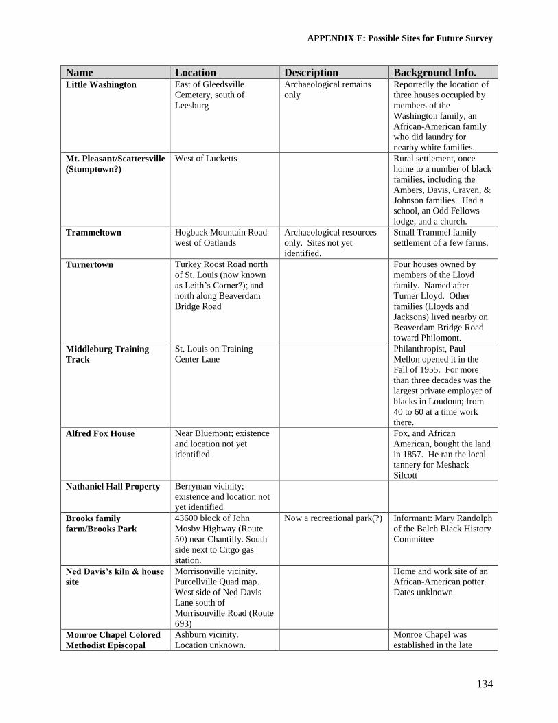
APPENDIX E: Possible Sites for Future Survey
134
Name Location Description Background Info. Little Washington East of Gleedsville
Cemetery, south of
Leesburg
Archaeological remains
only
Reportedly the location of
three houses occupied by
members of the
Washington family, an
African-American family
who did laundry for
nearby white families.
Mt. Pleasant/Scattersville
(Stumptown?)
West of Lucketts Rural settlement, once
home to a number of black
families, including the
Ambers, Davis, Craven, &
Johnson families. Had a
school, an Odd Fellows
lodge, and a church.
Trammeltown Hogback Mountain Road
west of Oatlands
Archaeological resources
only. Sites not yet
identified.
Small Trammel family
settlement of a few farms.
Turnertown Turkey Roost Road north
of St. Louis (now known
as Leith’s Corner?); and
north along Beaverdam
Bridge Road
Four houses owned by
members of the Lloyd
family. Named after
Turner Lloyd. Other
families (Lloyds and
Jacksons) lived nearby on
Beaverdam Bridge Road
toward Philomont.
Middleburg Training
Track
St. Louis on Training
Center Lane
Philanthropist, Paul
Mellon opened it in the
Fall of 1955. For more
than three decades was the
largest private employer of
blacks in Loudoun; from
40 to 60 at a time work
there.
Alfred Fox House Near Bluemont; existence
and location not yet
identified
Fox, and African
American, bought the land
in 1857. He ran the local
tannery for Meshack
Silcott
Nathaniel Hall Property Berryman vicinity;
existence and location not
yet identified
Brooks family
farm/Brooks Park
43600 block of John
Mosby Highway (Route
50) near Chantilly. South
side next to Citgo gas
station.
Now a recreational park(?) Informant: Mary Randolph
of the Balch Black History
Committee
Ned Davis’s kiln & house
site
Morrisonville vicinity.
Purcellville Quad map.
West side of Ned Davis
Lane south of
Morrisonville Road (Route
693)
Home and work site of an
African-American potter.
Dates unklnown
Monroe Chapel Colored
Methodist Episcopal
Ashburn vicinity.
Location unknown.
Monroe Chapel was
established in the late

APPENDIX E: Possible Sites for Future Survey
135
Name Location Description Background Info. Church Cemetery 1800s. The church is no
longer extant.
Zilpha’s Rock / Zilpha
Davis House site)
Hillsboro – on North Fork
of Catoctin Creek, west of
Gaver Mill Road
Log house where she lived
may have been moved
from its original location.
Now located above the
creek on the north side of
Gaver Mill Road –
remodeled and covered in
weatherboard.
House and lot given to
Zilpha Davis, a former
slave freed in 1829 by
Samuel Pursel’s will.
Source: see Hamilton, The
Essence of a People II,
2002.
House, 39205 Stewart
Estate Lane
Stewartown/Bowmantown
vicinity
2-story, stuccoed frame
house (ca. 1900)
Access denied by owner.
House, 39237 Buchannon
Gap Road
Stewartown/Bowmantown
vicinity
1-1/2-story stuccoed,
frame house (ca. 1930)
Access denied by owner.
House, 39588 Moss Ridge
Road
Bowmantown Circa 1900(?) frame
house. Owner: Stewart
Access denied by owner.

136
APPENDIX F: Previously Documented Resources with Significance to
Loudoun’s African-American History

137
Name Location DHR i.d. # African-American significance William C. Bender
House
Morrisonville 053-0149 Home of Augustus & Annie Grigsby (or
Gregory) - African-Americans couple.
Purchased the land and house from
William Conner in 1883 for $250. Sold it
in 1925 to Ernest Ritchie for $375.
Informant: Mimi Baker to Deborah Lee.
Belmont Chapel /
Margaret Mercer
Monument /
Belmont
Ashburn vicinity 053-0278
(archaeological site,
burned in 1967)
053-0106 (standing)
Margaret Mercer of Maryland purchased
Belmont in 1836 where she established a
girls’ school and a church. She taught her
slaves to read and write and freed them.
She supported the Colonization movement.
Former Grant
School / Marshall
Street Community
Center
Middleburg 259-0162-0013 Southern end of current building erected in
1888 as the town’s first public school for
African-American children. Closed in
1948 after Banneker School opened in St.
Louis. Expanded and converted for use as
a community center that remained open
until 1981. Belmont listed on the National
Register in 1980.
Trevor Hill /
Rosemont
Waterford vicinity 053-0493 Property includes two log slave quarters, a
rare example of a grouping of quarters in
Loudoun.
Rockland Leesburg 053-0096 or 053-0012-
0027
Includes one circa 1822, two-story, brick
slave quarter. List on the National Register
in 1987.
Mt. Zion Old School
Baptist Church and
Cemetery
Aldie vicinity
40309 John
Mosby Highway
053-0339
44LD0547
(archaeological site)
Listed on the National Register in 1998.
Cemetery reputedly includes the unmarked
graves of African-American members of
the church.
Waterford
“Colored” School /
African Church &
School / Second
Street School
Waterford 401-0032 Part of Waterford National Register
Historic District. Circa 1866 African-
American school. One of the earliest black
schools in the county.
Goose Creek
Meeting House
Complex – Oakdale
School
Lincoln 053-0305 Listed on the National Register in 1974.
Quaker-run school built in 1815. The first
―public‖ school in the county. It
accommodated both white and African-
American children.
Marble Quarry Mountville
vicinity
053-0385 Marble quarry opened in 1875 by the
Virginia Marble Company. Became major
employer of African Americans in the area
and spawned the establishment of the
settlement of Marble Quarry nearby.
Houses in
Middleburg’s
African-American
neighborhood
Middleburg
301, 306, 306A,
308, 310 East
Marshall St.
259-0162-0003, -0004,
-0005, -0006, & -0010
Houses owned and/or occupied by African
Americans in an area historically known as
―Bureau Corner‖ where many African
Americans lived in Middleburg.
Shiloh Baptist
Church and
Parsonage
Middleburg 259-0162-0007 & -
0008
African-American congregation established
in 1867. Current church built in 1913.
Asbury Methodist
Church & Parsonage
Middleburg 259-0162-0011 & -
0012
Oldest independent African-American
congregation in Loudoun. Established in
1864. Building erected in 1829 for a white
congregation.

138
Name Location DHR i.d. # African-American significance Hansborough House
/ Freedmen’s Bureau
Office
Middleburg 259-0162-0014 Served as the office of the freedmen’s
Bureau in Middleburg during the post-Civil
War era of Reconstruction.
Back Street Café Middleburg 259-0162-0124 Built by William Hall for his son.
Schooley House
(Elizabeth Simms
House)
Waterford
(40153 Janney
Street)
401-0047 Elizabeth Simms, an African-American
laundress, occupied this house for over 50
years. In National Register Historic
District, listed 1969.
Oatlands South of Leesburg 053-0093 The grounds of the National Trust-owned
National Register-listed property include
the living and workplaces of the any
African-American slaves owned by the
Carter family.
Claude Moore Park
(Lanesville House &
Outbuildings)
Sterling
21544 Cascades
Parkway
053-0498 Research being done on slave named Isaac
who belonged to one of the owners, John
Keene (died 1817). Informant: Meredyth
Breed, Asst. Park Manager, 703-421-6561.
John Wesley
Methodist Episcopal
Church
Waterford
Bond Street and
Main Street
401-0077 Land purchased in 1888 by African
Methodist Episcopal Church trustees.
Dedicated church in 1891. Open until
1968.
House, 11 S. Liberty
Street
Middleburg
11 S. Liberty
Street
259-0162-0085 Also known as ―Rusty Hut.‖ House was
purchased by noted African-American
stonemason and businessman, William N.
Hall, in 1931. Hall gave it to his son Lloyal
Hall.
The Shades /
Shuman-Hall House
Middleburg
14 E. Federal
Street
259-0162-0127 Purchased by noted African-American
stonemason and businessman, William N.
Hall, in 1919. House became known as the
Hall family ―homeplace.‖ William left it to
his son, Albert. Sold out of the family in
1973. Source: Destination Middleburg: A
Walking Tour Into The Past, 2001.
Cook Family House Middleburg
904 E.
Washington Street
259-5020 Circa 1925 Craftsman Bungalow
associated with the Cook family in
Loudoun.
Tibbs Family House Middleburg
900 E.
Washington Street
259-5019 Circa 1955, 2-story, frame house associated
with the Tibbs family.
Springdale / Samuel
M. Janney House
Lincoln vicinity 053-0324 Built 1832 by Quaker minister, Samuel
Janney who was a noted abolitionist. Local
lore suggests that the house was a stop on
the Underground Railroad.