
Long-term habitat changes in a protected area ...
15
RESEARCH ARTICLE Long-term habitat changes in a protected area: Implications for herpetofauna habitat management and restoration Chantel E. Markle*, Gillian Chow-Fraser ¤ , Patricia Chow-Fraser Department of Biology, McMaster University, Hamilton, Ontario, Canada ¤ Current address: School of Environmental Studies, University of Victoria, British Columbia, Canada * [email protected] Abstract Point Pelee National Park, located at the southern-most tip of Canada’s mainland, histori- cally supported a large number of herpetofauna species; however, despite nearly a century of protection, six snake and five amphibian species have disappeared, and remaining spe- cies-at-risk populations are thought to be in decline. We hypothesized that long-term changes in availability and distribution of critical habitat types may have contributed to the disappearance of herpetofauna. To track habitat changes we used aerial image data span- ning 85 years (1931–2015) and manually digitized and classified image data using a stan- dardized framework. Change-detection analyses were used to evaluate the relative importance of proportionate loss and fragmentation of 17 habitat types. Marsh habitat diver- sity and aquatic connectivity has declined since 1931. The marsh matrix transitioned from a graminoid and forb shallow marsh interspersed with water to a cattail dominated marsh, altering critical breeding, foraging, and overwintering habitat. Reduced diversity of marsh habitats appears to be linked to the expansion of invasive Phragmites australis, which invaded prior to 2000. Loss of open habitats such as savanna and meadow has reduced availability of high quality thermoregulation habitat for reptiles. Restoration of the northwest- ern region and tip of Point Pelee National Park to a mixed landscape of shallow wetlands (cattail, graminoid, forb, open water) and eradication of dense Phragmites stands should improve habitat diversity. Our results suggest that long-term landscape changes resulting from habitat succession and invasive species can negatively affect habitat suitability for her- petofauna and protection of land alone does not necessarily equate to protection of sensitive herpetofauna. Introduction The rate of landscape change and the extent at which it affects species-at-risk has escalated since the onset of the Anthropocene [1]. Many ecosystems have become increasingly com- posed of a mix of historical and novel habitats, making it difficult to evaluate future conserva- tion actions and resource management strategies [2]. However, this decision-making process PLOS ONE | https://doi.org/10.1371/journal.pone.0192134 February 14, 2018 1 / 15 a1111111111 a1111111111 a1111111111 a1111111111 a1111111111 OPEN ACCESS Citation: Markle CE, Chow-Fraser G, Chow-Fraser P (2018) Long-term habitat changes in a protected area: Implications for herpetofauna habitat management and restoration. PLoS ONE 13(2): e0192134. https://doi.org/10.1371/journal. pone.0192134 Editor: Tim A. Mousseau, University of South Carolina, UNITED STATES Received: April 21, 2017 Accepted: January 17, 2018 Published: February 14, 2018 Copyright: © 2018 Markle et al. This is an open access article distributed under the terms of the Creative Commons Attribution License, which permits unrestricted use, distribution, and reproduction in any medium, provided the original author and source are credited. Data Availability Statement: All relevant data are within the paper and its Supporting Information files. Funding: We acknowledge partial funding from the Natural Sciences and Engineering Research Council of Canada, Alexander Graham Bell Canada Doctoral Graduate Scholarship (http://www.nserc- crsng.gc.ca) to CEM and a grant to PC-F from the Highway Infrastructure and Improvement Program from the Ontario Ministry of Transportation. The funders had no role in study design, data collection
Transcript of Long-term habitat changes in a protected area ...

RESEARCH ARTICLE
Long-term habitat changes in a protected
area: Implications for herpetofauna habitat
management and restoration
Chantel E. Markle*, Gillian Chow-Fraser¤, Patricia Chow-Fraser
Department of Biology, McMaster University, Hamilton, Ontario, Canada
¤ Current address: School of Environmental Studies, University of Victoria, British Columbia, Canada
Abstract
Point Pelee National Park, located at the southern-most tip of Canada’s mainland, histori-
cally supported a large number of herpetofauna species; however, despite nearly a century
of protection, six snake and five amphibian species have disappeared, and remaining spe-
cies-at-risk populations are thought to be in decline. We hypothesized that long-term
changes in availability and distribution of critical habitat types may have contributed to the
disappearance of herpetofauna. To track habitat changes we used aerial image data span-
ning 85 years (1931–2015) and manually digitized and classified image data using a stan-
dardized framework. Change-detection analyses were used to evaluate the relative
importance of proportionate loss and fragmentation of 17 habitat types. Marsh habitat diver-
sity and aquatic connectivity has declined since 1931. The marsh matrix transitioned from a
graminoid and forb shallow marsh interspersed with water to a cattail dominated marsh,
altering critical breeding, foraging, and overwintering habitat. Reduced diversity of marsh
habitats appears to be linked to the expansion of invasive Phragmites australis, which
invaded prior to 2000. Loss of open habitats such as savanna and meadow has reduced
availability of high quality thermoregulation habitat for reptiles. Restoration of the northwest-
ern region and tip of Point Pelee National Park to a mixed landscape of shallow wetlands
(cattail, graminoid, forb, open water) and eradication of dense Phragmites stands should
improve habitat diversity. Our results suggest that long-term landscape changes resulting
from habitat succession and invasive species can negatively affect habitat suitability for her-
petofauna and protection of land alone does not necessarily equate to protection of sensitive
herpetofauna.
Introduction
The rate of landscape change and the extent at which it affects species-at-risk has escalated
since the onset of the Anthropocene [1]. Many ecosystems have become increasingly com-
posed of a mix of historical and novel habitats, making it difficult to evaluate future conserva-
tion actions and resource management strategies [2]. However, this decision-making process
PLOS ONE | https://doi.org/10.1371/journal.pone.0192134 February 14, 2018 1 / 15
a1111111111
a1111111111
a1111111111
a1111111111
a1111111111
OPENACCESS
Citation: Markle CE, Chow-Fraser G, Chow-Fraser
P (2018) Long-term habitat changes in a protected
area: Implications for herpetofauna habitat
management and restoration. PLoS ONE 13(2):
e0192134. https://doi.org/10.1371/journal.
pone.0192134
Editor: Tim A. Mousseau, University of South
Carolina, UNITED STATES
Received: April 21, 2017
Accepted: January 17, 2018
Published: February 14, 2018
Copyright: © 2018 Markle et al. This is an open
access article distributed under the terms of the
Creative Commons Attribution License, which
permits unrestricted use, distribution, and
reproduction in any medium, provided the original
author and source are credited.
Data Availability Statement: All relevant data are
within the paper and its Supporting Information
files.
Funding: We acknowledge partial funding from the
Natural Sciences and Engineering Research
Council of Canada, Alexander Graham Bell Canada
Doctoral Graduate Scholarship (http://www.nserc-
crsng.gc.ca) to CEM and a grant to PC-F from the
Highway Infrastructure and Improvement Program
from the Ontario Ministry of Transportation. The
funders had no role in study design, data collection

benefits from understanding the historic landscape and tracking long-term environmental
changes [3,4]. Identification of long-term trends in habitat changes may elucidate drivers of
ecological processes, and therefore, help understand mechanisms of landscape changes [5].
This is important because, while habitat succession is a natural process, succession and
changes can affect landscape suitability either positively or negatively depending on the target
species.
Landscape change through fragmentation and the direct loss of habitat prohibits or signifi-
cantly impairs species’ ability to carry out critical life activities such as foraging, overwintering,
and breeding. In addition, habitat loss and fragmentation can isolate critical habitats or entire
populations (e.g., [6]), reduce genetic diversity (e.g., [7]), decrease the potential for rescue
effects (e.g., [8]), and result in local species extinctions [9,10]. Reptiles and amphibians, collec-
tively referred to as herpetofauna, have experienced recent global population declines fre-
quently linked to habitat loss, fragmentation, and degradation [11–15]. Herpetofauna depend
on diverse wetland habitat for breeding, foraging, and winter refugia. In addition to wetlands,
many reptiles and amphibians rely on adjacent terrestrial habitat [16]. For instance, turtles
require terrestrial habitat for nesting and estivation [17,18], some snakes hibernate on land
[19,20], and after breeding, some anurans will move upland to forage and overwinter [21]. A
tight spatial coupling between wetland and terrestrial habitat is critical for a diverse range of
herpetofauna to successfully carry out life activities.
The protection of natural lands is vital for conservation of biodiversity [22]; however, pro-
tection of lands alone is not always sufficient for maintaining historic species diversity. This
seems to be the case for Point Pelee National Park (PPNP) located at the southern-most tip of
Canada’s mainland, which has lost several herpetofauna species despite nearly a century of
protection from human disturbance [23]. Although agricultural practice and human infra-
structure has been limited within the protected park, there have been suspected changes in
appropriate habitat for herpetofauna. Over time, the park has seen the extirpation of five
amphibian (i.e., Northern cricket frog (Acris crepitans), Eastern tiger salamander (Ambystomatigrinum), Fowler’s toad (Anaxyrus fowleri), gray treefrog (Hyla versicolor), American bullfrog
(Lithobates catesbeianus)) and six snake species (i.e., blue racer (Coluber constrictor foxii), tim-
ber rattlesnake (Crotalus horridus), gray ratsnake (Pantherophis spiloides), Eastern hog-nosed
snake (Heterodon platirhinos), milksnake (Lampropeltis triangulum), massasauga (Sistruruscatenatus)), with a suspected extirpation of the Endangered spotted turtle (Clemmys guttata)
that was last seen in the park in the early 1990s [24]. Currently, the park supports several at-
risk reptile species, though evidence suggests that recruitment is limited for the snapping turtle
population (Chelydra serpentina [25]). Continued loss of herpetofauna is of conservation con-
cern, and identification and quantification of habitat changes in the park can inform manage-
ment and habitat restoration efforts.
Our primary objective was to determine if habitat changes have occurred within PPNP over
the last 85 years, and subsequently, to quantify changes in habitat area, type and configuration.
Given that PPNP has been protected from anthropogenic stressors such as habitat alteration,
long-term changes in availability and distribution of habitats types may have contributed to
the disappearance of herpetofauna. We use a multi-scale approach to examine changes in habi-
tat critical for herpetofauna. Specifically, we evaluate spatiotemporal changes in shallow marsh
habitats suitable for breeding, feeding and overwintering for turtles [18] and anurans [21],
upland and sandy habitats that provide nesting habitat for turtles [18], and thermoregulation
habitat and refugia for snakes [26,27]. Our second objective was to identify areas that have
experienced the greatest habitat changes or loss of suitable herpetofauna habitat.
Implications of long-term habitat changes on herpetofauna in a protected area
PLOS ONE | https://doi.org/10.1371/journal.pone.0192134 February 14, 2018 2 / 15
and analysis, decision to publish, or preparation of
the manuscript.
Competing interests: The authors have declared
that no competing interests exist.
Methods
Study site
Point Pelee is a 16 km2 National Park located on the north shore of Lake Erie at the southern-
most tip of Canada’s mainland. The park was established in 1918 and is a popular tourist desti-
nation, hosting 300,000–500,000 visitors annually [23]. Point Pelee National Park is located
within the Carolinian zone, one of the most diverse Canadian regions for herpetofauna. Point
Pelee is also recognized as an Important Bird Area and a Wetland of International Significance
by UNESCO [28].
Habitat delineation and classification
Historical aerial photography is an effective way of informing ecological restoration surround-
ing herpetofauna, because it captures spatial and temporal changes in herpetofauna critical
habitat suspected to drive these species’ declines [11,13]. Unlike other historical records, repeat
aerial imagery present the opportunity to help guide justifiable restoration goals by assessing
environmental baselines and the variability of ecological processes over time [5]. Moreover, it
allows for measuring changes in spatial patterns of critical habitat important to species of
interest (e.g., [29,30]). To quantify habitat changes that have occurred in PPNP, we acquired
image data for the years 1931, 1959, 1973, 1977, 1985, 1990, 2000, 2004, 2010 and 2015 to com-
plete a multi-date data classification (Table 1). We digitized image data and classified habitats
in ArcGIS 10.3 (ESRI, Redlands, California, USA) at a map scale of 1:1500. When examining
habitat change derived from image data, our detection analyses are only as accurate as each
individual classified product [31]. These errors are inherent with any historical image classifi-
cation since derived data cannot be ground-truthed. We minimized compound errors by cre-
ating and adhering to a formal delineation and classification framework for each image
(Table 2; S1 Table). To maintain nomenclature consistency, we adapted habitat ecosite and
vegetation names from Dougan and Associates [32], who previously completed an Ecological
Land Classification for Point Pelee National Park. Although we classified the delineated habi-
tats to ecosite, not all ecosite classes were used to facilitate comparisons among years. There-
fore, agriculture, constructed, forest, meadow, woodland, savanna, thicket and swamp were
used at the community class level in our final analyses (Table 2).
Habitat loss and fragmentation
We measured habitat areas in ArcGIS 10.3 and calculated change in total area on a temporal
scale. We expressed all habitat types as a percentage of the total delineated park area and
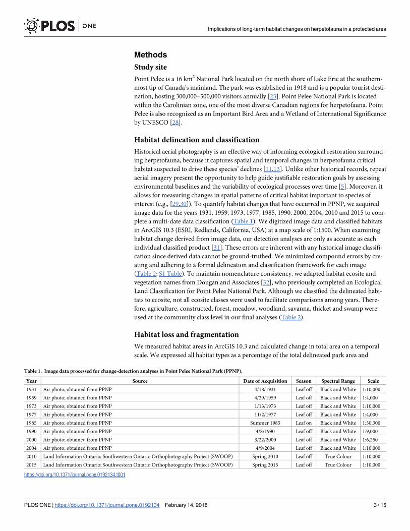
Table 1. Image data processed for change-detection analyses in Point Pelee National Park (PPNP).
Year Source Date of Acquisition Season Spectral Range Scale
1931 Air photo; obtained from PPNP 4/18/1931 Leaf off Black and White 1:10,000
1959 Air photo; obtained from PPNP 4/29/1959 Leaf off Black and White 1:4,000
1973 Air photo; obtained from PPNP 1/13/1973 Leaf off Black and White 1:10,000
1977 Air photo; obtained from PPNP 11/2/1977 Leaf off Black and White 1:4,000
1985 Air photo; obtained from PPNP Summer 1985 Leaf on Black and White 1:30,300
1990 Air photo; obtained from PPNP 4/8/1990 Leaf off Black and White 1:9,000
2000 Air photo; obtained from PPNP 3/22/2000 Leaf off Black and White 1:6,250
2004 Air photo; obtained from PPNP 4/9/2004 Leaf off Black and White 1:10,000
2010 Land Information Ontario; Southwestern Ontario Orthophotography Project (SWOOP) Spring 2010 Leaf off True Colour 1:10,000
2015 Land Information Ontario; Southwestern Ontario Orthophotography Project (SWOOP) Spring 2015 Leaf off True Colour 1:10,000
https://doi.org/10.1371/journal.pone.0192134.t001
Implications of long-term habitat changes on herpetofauna in a protected area
PLOS ONE | https://doi.org/10.1371/journal.pone.0192134 February 14, 2018 3 / 15

compared relative changes in habitat losses and gains over time. Though marsh water levels
may have fluctuated between years, underlying substrate generally maintains habitat type and
instead would result in a change in vegetation density. Total area of park should, therefore, be
more representative of temporal variation in habitat composition. To determine if serial auto-
correlation was present in our dataset, we used the Durbin-Watson test. We also used a spear-
man’s correlation to determine if change in habitat area was correlated with Lake Erie water
levels (Data obtained from Great Lakes Water Level Dashboard, www.glerl.noaa.gov).
We calculated a variety of metrics in FragStats 4.2 [33] to quantify habitat loss and fragmen-
tation within the park at both the landscape and habitat class scale. For the purposes of our
study, we defined the landscape as Point Pelee National Park, comprising a mosaic of habitat
patches. At the landscape scale, we investigated changes to the area and distribution of patches,
as well as overall habitat diversity using Shannon’s and Simpson’s diversity index and Simp-
son’s evenness. At the class scale, we analyzed changes to the area and distribution of specific
habitat classes. We used linear regression to determine the relationship between fragmentation
metrics and time. Prior to calculating metrics, we converted habitat data to rasters with a cell
size of 2 m to ensure patch boundaries were accurately represented and that visually connected
features remained connected in the raster surface. To characterize fragmentation, we quanti-
fied change in landscape division and patch distribution using effective mesh size and splitting
Table 2. Habitat types classified in image data for Point Pelee National Park.
Habitat Class Description
Agriculture Active or inactive agricultural fields, including coniferous plantations and orchards.
Constructed Buildings, roads and trails.
Common Reed Graminoid
MMM
Dense invasive Phragmites australis australis typically growing in circular shapes
throughout the marsh.
Cattail OSM Very low edge-to-interior ratio (high density) of cattails (T. latifolia, T. angustifolia, T.
x glauca) with homogenous appearance, almost no visible pools of open water.
Graminoid OSM Medium edge-to-interior ratio of mixed broad-leaved or narrow-leaved emergents
interspersed with water (medium density).
Forb OSM High edge-to-interior ratio of broad-leaved or narrow-leaved emergents with many
small pools (low density).
Graminoid MMM Little to no standing water, dense monospecific grass stands.
Mixed MMM Small, wet meadow with diverse floral communities, often found between dune and
extensive marsh communities.
Open Water Open water, devoid of vegetation
Meadow Open terrestrial area with homogenous spread of grasses, < 25% tall shrub cover.
Includes dry-fresh graminoid and mixed meadow ecosites.
Forest > 75% cover of deciduous or coniferous, or > 25% both coniferous and deciduous.
Includes dry-fresh cedar, poplar, deciduous, white pine forest, and fresh-moist poplar
forest ecosites.
Woodland 35–60% cover of deciduous or coniferous trees. Includes dry-fresh cedar coniferous,
deciduous and mixed woodland ecosites.
Savanna 10–35% cover of deciduous or coniferous trees. Includes dry-fresh cedar coniferous
and mixed savanna ecosites.
Thicket Open area with > 25% tall shrub cover and little tree cover. Includes dry-fresh and
fresh-moist deciduous thicket, and deciduous shrub thicket ecosites.
Swamp Wetland characterized by presence of deciduous or coniferous trees. Includes maple
mineral deciduous swamp, and mineral deciduous thicket swamp ecosites.
Sand Barren/ Dune Low hill or ridge of sand either inland or lining the land, vegetation may include
shrubs and trees. Includes open, shrub, treed sand barren and dune ecosites.
Shoreline Community that lies adjacent to Lake Erie, rarely any vegetation. Includes mineral
open and shrub shoreline ecosites.
https://doi.org/10.1371/journal.pone.0192134.t002
Implications of long-term habitat changes on herpetofauna in a protected area
PLOS ONE | https://doi.org/10.1371/journal.pone.0192134 February 14, 2018 4 / 15

index [33]. The splitting index is the number of patches after dividing the landscape into
patches of equal size that would result in the same degree of landscape division, and is irrespec-
tive of patch size, shape, and relative location. Effective mesh size is the size of the patches
when the landscape is divided in S areas of the same size (where S = splitting index).
We quantified habitat change using patch and core area metrics standardized by the pro-
portional abundance of each habitat type (area-weighted metrics [33]). We calculated mean
patch area and the mean radius of gyration to measure patch extent and to determine the aver-
age distance a species can move within a specific patch before reaching the patch boundary.
Lastly, we calculated core area metrics to estimate the amount of interior habitat after account-
ing for edge habitat. We quantified the change in core area, number of disjunct core areas, and
the core area index (i.e., the percentage of core area). Examining core area is important
because the measure integrates both the size and shape of the patch. The amount of core area
will drastically differ between two patches of the same total size if one patch is a perfect circle
and the second is elongated and narrow. Core area metrics provide an indication of how far a
species would have to travel before accessing another habitat type, as well as the ratio of edge
to interior habitat, a variable that is relevant to species adversely affected by edges [34] or that
select for edge habitat [35,36]. When determining core area, we treated 15 m as edge habitat
based on the average daily distance moved by spotted turtles (30 m [37,38]) and previous
research on habitat use by snakes [35,36].
Change-detection
To identify change hotspots that could be used to direct restoration, we conducted a change-
detection analysis in ArcGIS 10.3. We examined change-detection rasters to identify which
habitat types replaced those that had been lost. We chose images that had been acquired many
decades apart. We could not use the earliest image acquired in 1931 due to low resolution, but
instead used the 1959 image, which had a suitably high resolution, and the 2015 image, which
is the most recently available.
Results
Landscape-level habitat changes
At the landscape scale, habitat in Point Pelee National Park has become less diverse and more
homogenous. In all cases the Durbin-Watson test was not significant (DW< 2, p> 0.5); there-
fore, no serial autocorrelation was present in our dataset. Mean patch area and mean patch
extent (radius of gyration) increased at a rate of 1.84 ha per year and 2.98 ha per year, respec-
tively (Table 3). The amount of mean core habitat in PPNP increased by 200% from 1931 to
2015 (Table 3). The mosaic of unique natural habitats declined through time from 26 to 8
patches (splitting index) and, on average, each patch increased by 128 ha (effective mesh size;
Table 3).
Class-level habitat changes
Substantial changes in land cover proportions occurred in PPNP over the last 85 years (Fig 1),
with the greatest occurring in the marsh (Fig 2A). Most notably, cattail organic marsh has dou-
bled in total area from 309 ha to 625 ha (Fig 2A), while graminoid shallow marsh has decreased
by 80% (S1 Table). Following a peak in 1959, the areal cover of forb shallow marsh has gener-
ally declined (Fig 2A). Although Phragmites had invaded the park prior to the end of the last
century, the 2000 image was the earliest in which we could positively identify its presence.
Over the course of the following 15 years, the number of Phragmites patches expanded from 4
Implications of long-term habitat changes on herpetofauna in a protected area
PLOS ONE | https://doi.org/10.1371/journal.pone.0192134 February 14, 2018 5 / 15

to 166 unique patches, increasing to a density of 11 patches per 100 ha (0.27 patches in 1931).
The amount of open water was relatively stable through time, comprising about 20% of the
park’s total area. Although not to the same extent as that of the marsh, there were also changes
in upland habitat classes (e.g., forest, thicket, savanna, and meadow classes; Fig 1); there was
an increase in forest and thicket habitat types, while the amount of swamp remained fairly con-
sistent (Fig 2B). Total forest area increased as mean patch area increased to 50 ha and patch
extent reached 560 m (Table 3). Noticeable declines were observed for savanna and meadow
habitats. About half of the core meadow habitat was lost between 1931 and 2015 (core area
index; Table 3). The amount of sand dune habitat has remained consistent since 1990, but the
proportion of treed and shrubby dune habitat significantly declined by 30 ha (R2 = 0.90,
p< 0.0001). Active management within the park boundaries led to the decommissioning of all
agricultural lands and reduced the number of buildings and roads since the 1930s (Fig 2C).
In 1931, the matrix (i.e., dominant habitat type in which patches are distributed throughout
PPNP) was graminoid organic shallow marsh, with open water and forb organic shallow marsh
interspersed. We detected a major change in the matrix that occurred between 1959 and 1973,
when cattail organic shallow marsh became the dominant and most extensive feature and
continued to take over the marsh until present-day conditions. Mean area for a cattail patch
increased significantly from 64 ha to 336 ha, expanding at a rate of 4.12 ha per year (Table 3).
The mean radius of gyration increased by 7.43 m per year, increasing from 377 m to almost a
kilometer in extent. The core area of dense cattail habitat currently comprises 42% of the park
landscape, with the largest patch totaling 28% of the cattail area. Furthermore, when we divided
the landscape into patches of equal sizes, the amount of cattail increased from 13 ha to 142 ha
(Table 3). In contrast to cattail habitat, percentage of available forb core area has been completely
lost from the park (declined to 0% from 50%; Table 3), leaving the remaining 1.2 ha as edge
habitat. Although the amount of open water remained consistent through time (Fig 2A), the
percentage of available core area has increased to 83%, but the number of disjunct areas has
declined from 79 to 33 patches, indicating an overall reduction in aquatic connectivity (Table 3).
Table 3. Metrics used to describe habitat changes in Point Pelee National Park at the landscape and class scale.
Scale Habitat Metric R2 Rate of change p -value 1931 2015
Landscape
n/a AW Mean Patch Area 0.81 1.84 ha/yr 0.0009 67.7 ha 186.0 ha
AW Mean Radius of Gyration 0.67 2.98 m/yr 0.0066 532.1 m 714.1 m
AW Mean Core Area 0.82 1.64 ha/yr 0.0008 50.8 ha 155.0 ha
Effective Mesh Size 0.84 1.92 ha/yr 0.0005 58.4 ha 186 ha
Splitting Index 0.91 -0.23 patches/yr < 0.0001 26.4 patches 8.0 patches
Shannon’s Diversity Index 0.92 -0.008 /yr < 0.0001 2.4 1.8
Simpson’s Diversity Index 0.90 -0.002 /yr 0.0001 0.88 0.75
Simpson’s Evenness 0.89 -0.002 /yr 0.0001 0.93 0.80
Class Cattail OSM AW Mean Patch Area 0.84 4.12 ha/yr 0.0005 63.9 ha 336.1 ha
AW Mean Radius of Gyration 0.82 7.43 m/yr 0.0007 377.4 m 903.2 m
Effective Mesh Size 0.83 2.12 ha/yr 0.0006 12.8 ha 141.8 ha
Open Water AW Mean Core Area Index 0.57 0.11%/yr 0.01 75.1% 83.4%
Number of Disjunct Core Areas 0.55 -0.73 areas/yr 0.01 79 33
Forb OSM AW Mean Core Area Index 0.57 -0.53%/yr 0.02 49.6% 0.00%
Forest AW Mean Patch Area 0.82 0.47 ha/yr 0.0004 4.2 ha 49.8 ha
AW Mean Radius of Gyration 0.75 4.68 m/yr 0.0012 128.3 m 558.8 m
Meadow AW Mean Core Area Index 0.46 -0.46 0.03 64.1% 33.7%
Each metric was regressed against year to determine rate of change during our study period (1931–2015). AW = area-weighted.
https://doi.org/10.1371/journal.pone.0192134.t003
Implications of long-term habitat changes on herpetofauna in a protected area
PLOS ONE | https://doi.org/10.1371/journal.pone.0192134 February 14, 2018 6 / 15

Point Pelee is a sand spit and is constantly subjected to erosional and depositional forces.
Throughout 1931 to 2015, erosional forces have been greater than depositional forces along
the eastern shorelines. Although the western shoreline has seen some deposition, there was a
net loss in shoreline area totaling 72 ha. Total length of the shoreline has also decreased from
19.2 km to 18.0 km. The area of mineral shoreline and sand barrens/dunes has been declining
through time, with some observed fluctuations (Fig 2C; S1 Table). We found a significant neg-
ative correlation between water level of Lake Erie and the amount of shoreline (-0.75, p = 0.01)
and open sand barren/dune habitat (-0.76, p = 0.01; Fig 3) in PPNP; such a significant correla-
tion with water levels was not identified for any other habitat class. There was also a decline in
total park area over time, which appeared to be associated with Lake Erie water levels (Fig 4).
Although total park area tended to decline as water levels rose (1931–1985), it did not increase
when lower water levels returned between 1990 to 2015 (Fig 4). Consequently, PPNP has expe-
rienced an overall net loss of 58 ha since 1931.
Change-detection
Our change-detection analysis revealed that over 650 ha, 43–44% of the total park area, under-
went a change in habitat type between 1959 and 2015. Most notably, loss of forb and
Fig 1. Habitat composition throughout the sampling period (1931 to 2015) in Point Pelee National Park. The quality of the 1990 image did not
permit classification of marsh ecosites/vegetation types (i.e., common reed, cattail organic shallow marsh, graminoid organic shallow marsh, forb
organic shallow marsh) and is only presented at the community level (marsh). Habitat types comprising< 0.5% of the park are not shown.
https://doi.org/10.1371/journal.pone.0192134.g001
Implications of long-term habitat changes on herpetofauna in a protected area
PLOS ONE | https://doi.org/10.1371/journal.pone.0192134 February 14, 2018 7 / 15

graminoid marsh was succeeded by 139 ha and 188 ha of cattail marsh, respectively. Over 50
ha of open water was infilled by cattail marsh. As a result of management actions, approxi-
mately 89 ha of constructed and agricultural land was reclaimed as forest or thicket. The
increase in amount of forest was also because of succession of woodland areas (72 ha).
We identified five hotspots within the park that experienced major changes (Fig 5). There
are two hotspots in the marsh where habitat transitioned from a diverse mixture of broad- and
narrow-leaved emergent vegetation types interspersed with pools of water in 1959 to almost
being completely infilled by dense cattails in 2015 (Hotspot A and B; Fig 5A and 5B). In 2015,
Fig 2. Land-cover trends over 85 years in Point Pelee National Park. (a) Marsh habitats, excluding 1990. (b) Upland habitats. (c) Shoreline, beach
and anthropogenic classes. Habitat types comprising< 0.5% of the park are not shown.
https://doi.org/10.1371/journal.pone.0192134.g002
Implications of long-term habitat changes on herpetofauna in a protected area
PLOS ONE | https://doi.org/10.1371/journal.pone.0192134 February 14, 2018 8 / 15

over 90% of the Phragmites distribution had displaced marsh habitats (i.e., cattail, forb, grami-
noid OSM), while the remaining 10% occupied open water, swamps, and sand dunes. Concur-
rent with the spread of Phragmites throughout the park, large homogeneous stands infiltrated
marsh habitat towards the northern end (Hotspot C; Fig 5C); long stretches of Phragmites also
became established along majority of the eastern beach, creating a barrier between the beach
and marsh (Hotspot D and E; Fig 4D and 4E).
Discussion
Long-term habitat changes
Consistent with our expectations, we confirmed that long-term changes in habitat availability
and distribution have occurred in Point Pelee National Park. First, both the diversity of marsh
Fig 3. Plot of areal extent of Point Pelee National Park and open sand barren/dune as a function of annual mean
water level in Lake Erie (meters above sea level). Both areal extent of Point Pelee National Park and open sand
barren/dune were significantly correlated with water level (p = 0.01); Spearman’s rho correlation coefficient is shown
separately for each correlation.
https://doi.org/10.1371/journal.pone.0192134.g003
Fig 4. Total area of Point Pelee National Park from 1931 to 2015. A net loss of 58 ha was experienced over this time
period. Years with a larger park area tend to be associated with higher water levels and vice versa.
https://doi.org/10.1371/journal.pone.0192134.g004
Implications of long-term habitat changes on herpetofauna in a protected area
PLOS ONE | https://doi.org/10.1371/journal.pone.0192134 February 14, 2018 9 / 15

habitat and connectivity of aquatic habitat patches have been reduced over the past 85 years,
similar to changes noted in other Ontario wetlands [39]. Between 1959 and 1973, the marsh
matrix transitioned from a graminoid organic shallow marsh interspersed with patches of
Fig 5. Change in marsh habitat in Point Pelee National Park between 1959 and 2015. (a) and (b) indicate hotspots of major habitat change and infilling within the
marsh (solid-lined boxes). (c), (d), and (e) indicate hotspots of invasive common reed (dashed-lined boxes).
https://doi.org/10.1371/journal.pone.0192134.g005
Implications of long-term habitat changes on herpetofauna in a protected area
PLOS ONE | https://doi.org/10.1371/journal.pone.0192134 February 14, 2018 10 / 15

open water and forb organic shallow marsh, to a cattail-dominated marsh with very few
patches of open water. Such major changes in habitat distribution and isolation has implica-
tions for herpetofauna and their ability to access required habitat types during the active sea-
son. For instance, in 1931, there had been abundant shallow aquatic habitat that would have
provided important foraging, mating, and overwintering habitat for herpetofauna [18,21]. By
1973, however, the dispersed shallow pools had coalesced into large deep pools and had
become surrounded by large dense stands of cattails. In such a habitat matrix, herpetofauna
might have been forced to travel up to a kilometer through dense cattail stands to access critical
foraging and nesting habitat, such as graminoid and forb shallow marsh, mixed meadow
marsh, and sand barrens and dunes. Since patches throughout the landscape continued to
expand at a rate of 1.84 ha per year, unfavourable habitat patches (e.g., Phragmites) would have
become increasingly difficult to traverse, while critical habitats would have become more iso-
lated and disconnected.
High-quality thermoregulation habitat likely became a limiting factor for herpetofauna in
PPNP. For turtles, thermoregulation opportunities may have become severely reduced as
dense, homogenous cattail beds formed, leaving almost no open water [24]. For snakes, loss of
open terrestrial habitats such as savannas and meadows may have reduced important thermo-
regulation habitats. Open terrestrial habitats have been found to provide a variety of environ-
mental temperatures, and by basking or seeking shelter, snakes can control their body
temperature [40]. Moreover, the decline in treed and shrubby sand dunes reduces availability
of cover objects known to be important for certain snakes [27]. In a similar thermal environ-
ment to PPNP, snakes near Ottawa, Ontario, preferred open habitats over forest likely because
it enabled behavioural thermoregulation [40]. The lower thermal quality of forests compared
to open habitats resulted in snakes preferring open habitat at both the microhabitat and
macrohabitat scale [41]. In PPNP, there had been a succession from woodland habitat with
open canopy to forests with closed canopies, as well as a decline in savanna and meadow that
resulted in a total loss of 150 ha of open habitat; such a change could have resulted in reduced
thermoregulatory opportunities [42–44]. Furthermore, loss of large patches of early succes-
sional habitats has been identified as a factor contributing to declines in snake species richness
[45].
The third major habitat change in PPNP was the invasion of Phragmites australis into
marsh and beach habitats, posing a significant threat to the quality and amount of potential
breeding and nesting habitat for herpetofauna. Growth of Phragmites along the eastern beach
has created a potential barrier for species, particularly turtles, from moving between the marsh
and beach during the nesting season. In addition, growth of Phragmites in known turtle nest-
ing beaches can lower nest temperatures through shading [46]. In a similar sand dune and
shallow marsh ecosystem, the Fowler’s toad (Anaxyrus fowleri) experienced population
declines following loss of breeding habitat to Phragmites, even though there had been minimal
loss of adult habitat [47]. Although Phragmites was only at image-detectable levels in 2000, it
had invaded PPNP sometime between 1970 and 1990 [48], and continues to proliferate.
Legislation can protect a parcel of land from being altered by human activities, but it cannot
protect the parcel from changes in hydrological variability nor natural successional processes
that can affect marsh habitat and impact species that are reliant on a diverse, interconnected
system (e.g., [49]). Moreover, habitat availability and suitability are expected to evolve with cli-
mate change in light of predicted increases in temperature and decreases in precipitation [50].
As both natural and anthropogenically accelerated forces alter sensitive marsh habitats, active
management towards a more diverse vegetative and structural state will provide a range of
opportunities for feeding, breeding, overwintering, and thermoregulating, and likely benefit
the highest number of native and rare species.
Implications of long-term habitat changes on herpetofauna in a protected area
PLOS ONE | https://doi.org/10.1371/journal.pone.0192134 February 14, 2018 11 / 15

Habitat management and restoration
We identified five hotspots based on areas that have undergone the greatest amount of habitat
change. The first two hotspots were once characterized by a mix of shallow water wetlands
(cattail, graminoid, forb, open water) but have been completely succeeded by cattails. Efforts
to increase the number of open-water patches within cattail beds could provide movement
corridors and additional basking opportunities for reptiles; however, management strategies
must be carefully considered from a herpetological perspective to ensure no damage is done to
occupied habitats and individuals are not harmed.
We identified the next three hotspots as areas where Phragmites has either formed a barrier
wall between the marsh and the beach or formed large, dense homogeneous patches. The con-
trol of Phragmites is important to recovering beach nesting habitat and marsh habitat. In par-
ticular, the barrier of Phragmites between the beach and marsh is concerning for turtles in
search of nesting habitat. Resident wetlands and nesting sites must be closely linked and the
connecting corridor must provide passable habitat [51], which is likely not the case along the
eastern beach. If Phragmites continues to expand into sandy habitats, high water level years
can compress the amount of available nesting habitat since sand barren and dune habitats are
correlated with changes in Lake Erie water levels. Since 1931, we have identified a net loss of
58 ha of park area because of erosion, and the beach is vulnerable to further losses. Removal of
Phragmites along the beach is key in restoring connectivity to the marsh and maintaining high
quality nesting habitat.
In addition to the changes and losses in critical habitat we identified between 1931–2015,
there are additional stressors that may have directly or indirectly contributed to species
declines in PPNP including the historical loss of 2000 ha of marsh that existed beyond the cur-
rent park boundary [23], disturbances from high volumes of visitors [52], increases in meso-
predator species that predate on turtle eggs [23], historic use of chemicals [53], and the
geographic isolation of the park reducing immigration and rescue effects [8, 23].
Conclusion
Without actions to recover lost and degraded habitat herpetofauna species will continue to
lose critical habitat. Long-term persistence of herpetofauna is dependent upon access to critical
habitats for mating, foraging, nesting, and overwintering. We have provided several lines of
evidence to show how critical habitat has become lost and/or fragmented in Point Pelee over
the course of 85 years, even though this social-ecological-system had been protected as a
national park. We acknowledge that many factors contribute to the extirpation or decline of
a species; however, loss, fragmentation and degradation of habitat within the park boundary
has undoubtedly played a role in the decline of herpetofauna in PPNP, given that these are the
primary causes of species declines worldwide. Therefore, future management plans should
include restoring some of the original habitat features identified in this study and future
research should evaluate habitat management strategies from a herpetological perspective to
determine best practices. A time-sensitive step includes control of invasive Phragmites australisto prevent further encroachment on critical reproductive and thermoregulatory habitat. Habi-
tat restoration alone will not be enough to recover species at-risk but evaluation of historical
habitat and long-term changes is the cornerstone to assessing restoration needs and designing
an effective management approach. The creation of suitable habitat and assessment of long-
term changes can help support the incredible floral and faunal diversity of Point Pelee National
Park and contribute to a comprehensive feasibility study for re-establishing lost herpetofauna
[28].
Implications of long-term habitat changes on herpetofauna in a protected area
PLOS ONE | https://doi.org/10.1371/journal.pone.0192134 February 14, 2018 12 / 15

Supporting information
S1 Table. Landscape composition in hectares in Point Pelee National Park from 1931 to
2015. Habitat types are presented according to the greatest amount of change between 1931
and 2015. The quality of the 1990 image prevented classification beyond the marsh community
class and therefore we have no data (nd) for ecosites/vegetation types.
(DOCX)
Acknowledgments
We would like to thank Point Pelee National Park, especially Tammy Dobbie and Hiroo
Sawada for providing image data and insight necessary for this study.
Author Contributions
Conceptualization: Chantel E. Markle, Patricia Chow-Fraser.
Data curation: Chantel E. Markle, Gillian Chow-Fraser, Patricia Chow-Fraser.
Formal analysis: Chantel E. Markle.
Funding acquisition: Patricia Chow-Fraser.
Investigation: Chantel E. Markle, Gillian Chow-Fraser, Patricia Chow-Fraser.
Resources: Patricia Chow-Fraser.
Supervision: Patricia Chow-Fraser.
Visualization: Chantel E. Markle.
Writing – original draft: Chantel E. Markle.
Writing – review & editing: Chantel E. Markle, Gillian Chow-Fraser, Patricia Chow-Fraser.
References1. Maxwell SL, Fuller RA, Brooks TM, Watson JEM. The ravages of guns, nets and bulldozers. Nature
2016; 536:143–145. https://doi.org/10.1038/536143a PMID: 27510207
2. Hobbs RJ, Higgs E, Hall CH, Bridgewater P. Managing the whole landscape: historical, hybrid, and
novel ecosystems. Frontiers in Ecology and the Environment 2014; 12(1):557–564.
3. Hobbs RJ, Norton DA. Towards a conceptual framework for restoration ecology. Restoration Ecology
1996; 4(2):93–110.
4. Parsons D, Swetnam TW, Christensen NL. Uses and limitations of hisotrical variability concepts in man-
aging ecosystems. Ecological Applications 1999; 9(4):1177–1178
5. Swetnam TW, Allen CD, Betancourt JL. Applied historical ecology: using the past to manage for the
future 1999; 9(4):1189–1206.
6. Saunders DA, Hobbs RJ, Margules CR. Biological consequences of ecosystem fragmentation: a
review. Conservation Biology 1991; 5:18–32.
7. Dixo M, Metzger JP, Morgante JS, Zamudio KR. Habitat fragmentation reduces genetic diversity and
connectivity among toad populations in the Brazilian atlantic coastal forest. Biological Conservation
2009; 142:1560–1569.
8. Brown J, Lomolino M. Biogeography. Sunderland, Massachusetts, USA: Sinauer Associates, Inc.;
1998.
9. Diamond JM. Biogeographic kinetics: estimation of relaxation times for avifaunas of southwest Pacific
islands. Proceedings of the National Academy of Sciences 1972; 69:3199–3203.
10. Willis EO. Populations and local extinctions of birds on Barro Colorado Island, Panama. Ecological
Monographs 1974; 44:153–169.
Implications of long-term habitat changes on herpetofauna in a protected area
PLOS ONE | https://doi.org/10.1371/journal.pone.0192134 February 14, 2018 13 / 15

11. Bohm M, Collen B, Baillie JEM, Bowles P, Chanson J, Cox N, et al. The conservation status of the
world’s reptiles.” Biological Conservation 2013; 157:372–285.
12. Reading CJ, Luiselli LM, Akani GC, Bonnet X, Amori G, Ballouard JM, et al. Are snake populations in
widespread decline? Biology Letters 2010; 6(6):777–780. https://doi.org/10.1098/rsbl.2010.0373 PMID:
20534600
13. Stuart SN, Chanson JS, Cox NA, Young BE, Rodrigues ASL, Fischman DL,et al. Status and trends of
amphibian declines and extinctions worldwide. Science 2004; 306:1783–1786. https://doi.org/10.1126/
science.1103538 PMID: 15486254
14. Wilcove DS, Rothstein D, Dubow J, Phillips A, Losos E. Quantifying threats to imperiled species in the
United States: assessing the relative importance of habitat destruction, alien species, pollution, overex-
ploitation, and disease. BioScience 1998; 48:607–615.
15. Fahrig L. Relative effects of habitat loss and fragmentation on population extinction. The Journal of
Wildlife Management 1997; 61:603–610.
16. Gibbons JW. Terrestrial habitat: a vital component for herpetofauna of isolated wetlands. Wetlands
2003; 23:630–635.
17. Burke VJ, Gibbons JW. Terrestrial buffer zones and wetland conservation: a case study of freshwater
turtles in a Carolina bay. Conservation Biology 1995; 9:1365–1369.
18. Ernst CH, Lovich JE. Turtles of the United States and Canada. Baltimore, Massachusetts, USA: The
Johns Hopkins University Press; 2009.
19. Ultsch GR. Ecology and physiology of hibernation and overwintering among freshwater fishes, turtles,
and snakes. Biological Reviews 1989; 64:435–515.
20. Harvey DS, Weatherhead PJ. Hibernation site selection by eastern massasauga rattlesnakes (Sistrurus
catenatus catenatus) near their northern range limit. Journal of Herpetology 2006; 40:66–73.
21. Hecnar SJ. Great Lakes wetlands as amphibian habitats: a review. Aquatic Ecosystem Health & Man-
agement 2004; 7:289–303.
22. Juffe-Bignoli D, Harrison I, Butchart SH, Flitcroft R, Hermoso V, Jonas H, et al. Achieving Aichi Biodiver-
sity Target 11 to improve the performance of protected areas and conserve freshwater biodiversity.
Aquatic Conservation: Marine and Freshwater Ecosystems 2016; 26:133–151.
23. Hecnar SJ, Hecnar DR. Losses of amphibians and reptiles at Point Pelee National Park. Proceedings of
Parks Research Forum of Ontario; 2004 May 4–6; Lakehead University, Thunder Bay, Ontario, Can-
ada. Ontario: CASIOPA; 2010.
24. Hecnar SJ, Hecnar DR Feasibility of repatriation of extirpated herptiles to Point Pelee National Park.
Parks Canada; 2004. Contract No.: CR02-51.
25. Browne C, Hecnar SJ. Species loss and shifting population structure of freshwater turtles despite habi-
tat protection. Biological Conservation 2007; 138:421–429.
26. Row JR, Blouin-Demers G, Lougheed SC. Movements and habitat use of eastern foxsnakes (Panthero-
phis gloydi) in two areas varying in size and fragmentation. Journal of Herpetology 2012; 46:94–99.
27. Hecnar SJ, Hecnar DR. Microhabitat selection of woody debris by Dekay’s brownsnake (Storeria
dekayi) in a dune habitat in Ontario, Canada. Journal of Herpetology 2011; 45:478–483.
28. Parks Canada Agency. Multi-species action plan for Point Pelee National Park of Canada and Niagara
national historic sites of Canada. Parks Canada Agency; 2016.
29. Rhemtulla JM, Hall RJ, Higgs ES, Macdonald SE. Eighty years of change: vegetation in the Montane
ecoregion of Jasper National Park, Alberta, Canada. Canadian Journal of Forest Research 2002;
32:2010–2021. https://doi.org/10.1139/x02-112
30. Hessburg PF, Smith BG, Salter RB, Ottmar RD, Alvarado E. 2000. Recent changes (1930s-1990s) in
spatial patterns of interior northwest forests, USA. Forest Ecology and Management 2000; 136:53–83.
31. Stow D, Tinney L, Estes J. Deriving land use/land cover change statistics from LANDSAT: a study of
prime agricultural land. Proceedings of International Symposium on Remote Sensing of Environment;
1980 April 23–30; San Jose, Costa Rica. USA: Environmental Research Institute of Michigan; 1980.
32. Dougan and Associates. Point Pelee National Park Ecological Land Classification and plant species at
risk mapping and status. Parks Canada Agency; 2007.
33. McGarigal K, Cushman SS, Ene E. FRAGSTATS v4: Spatial pattern analysis program for categorical
and continuous maps. Computer software program produced by the authors at the University of Massa-
chusetts, Amherst, USA; 2012. Available from: http://www.umass.edu/landeco/research/fragstats/
fragstats.html.
34. Ries L, Fletcher RJ, Battin J, Sisk TD. Ecological responses to habitat edges: mechanisms, models,
and variability axplained. Annual Review of Ecology, Evolution, and Systematics 2004; 35:491–522.
Implications of long-term habitat changes on herpetofauna in a protected area
PLOS ONE | https://doi.org/10.1371/journal.pone.0192134 February 14, 2018 14 / 15

35. Blouin-Demers G, Weatherhead PJ. An experimental test of the link between foraging, habitat selection
and thermoregulation in black rat snakes Elaphe obsoleta obsoleta. Journal of Animal Ecology 2001;
70:1006–1013.
36. Blouin-Demers G, Weatherhead PJ. Habitat use by black rat snakes (Elaphe obsoleta obsoleta) in frag-
mented forests. Ecology 2001; 82:2882–2896.
37. Litzgus JD, Mousseau TA. Home range and seasonal activity of southern spotted turtles (Clemmys gut-
tata): implications for management. Copeia 2004; 2004:804–817.
38. Ernst CH. Ecology of the spotted turtle, Clemmys guttata (Reptilia, Testudines, Testudinidae), in south-
eastern Pennsylvania. Journal of Herpetology 1976; 10(1):25–33.
39. Wilcox DA, Kowalski KP, Hoare HL, Carlson ML, Morgan HN. Cattail invasion of sedge/grass meadows
in Lake Ontario: photointerpretation analysis of sixteen wetlands over five decades. Journal of Great
Lakes Research 2008; 34:301–323.
40. Row JR, Blouin-Demers G. Thermal quality influences effectiveness of thermoregulation, habitat use,
and behaviour in milksnakes. Oecologia 2006; 148:1–11. https://doi.org/10.1007/s00442-005-0350-7
PMID: 16425042
41. Row JR, Blouin-Demers G. Thermal quality influences habitat selection at multiple spatial scales in
milksnakes. Ecoscience 2006; 13(4):443–450.
42. Smith M, Bishop H. Mapping critical red cedar savannah habitat in Point Pelee National Park over the
past 69 years (1931–2000). Parks Canada; 2002.
43. Todd BD, Andrews KM. Response of a reptile guild to forest harvesting. Society for Conservation Biol-
ogy 2008; 22(3):753–761.
44. Pike DA, Webb JK, Shine R. Removing forest canopy cover restores a reptile assemblage. Ecological
Applications 2011; 21(1):274–280. PMID: 21516904
45. Kjoss VA, Litvaitis JA. Community structure of snakes in a human-dominated landscape. Biological
Conservation 2001; 98:285–292.
46. Bolton RM, Brooks RJ. Impact of the seasonal invasion of Phragmites australis (common reed) on turtle
reproductive success. Chelonian Conservation and Biology 2010; 9:238–243.
47. Greenberg DA, Green DM. Effects of an invasive plant on population dynamics in toads. Conservation
Biology 2013; 27:1049–1057. https://doi.org/10.1111/cobi.12078 PMID: 23692126
48. Catling PM, Mitrow G. The recent spread and potential distribution of Phragmites australis subsp. aus-
tralis in Canada. The Canadian Field-Naturalist 2011; 125:95–104.
49. Cooper JE, Mead JV, Farrell JM, Werner RG. Potential effects of spawning habitat changes on the seg-
regation of northern pike (Esox lucius) and muskellunge (E. masquinongy) in the Upper St. Lawrence
River. Hydrobiologia 2008; 601:41–53.
50. Colombo SJ, McKenney DW, Lawrence KM, Gray PA. Climate change projections for Ontario: Practical
information for policymakers and planners. Ministry of Natural Resources and Forestry; 2007. Report
No.: CCRR-05.
51. Environment Canada. Recovery strategy for the spotted turtle (Clemmys guttata) in Canada [Pro-
posed]. Environment Canada; 2016.
52. Hecnar SJ, M’Closkey RT. Effects of human disturbance on five-lined skink (Eumeces fasciatus) abun-
dance and distribution. Biological Conservation 1998; 85:213–222.
53. Russell RW, Hecnar SJ, Mouland G, Haffner GD. Pesticide accumulation in Point Pelee amphibians. In:
Pollock-Ellwand N, Van Osch K, Nelson JG, Beechey T, Stephenson W, Marsh J. Parks and protected
areas reasearch in Ontario: challenges to parks and protected areas in southern Ontario. Proceedings
of the Parks Research Forum of Ontario (PRFO) annual general meeting; 1999 April 22–23; Guelph,
Ontario, Canada: Heritage Resources Centre; 1999. p. 371–376.
Implications of long-term habitat changes on herpetofauna in a protected area
PLOS ONE | https://doi.org/10.1371/journal.pone.0192134 February 14, 2018 15 / 15


![Gene Expression Changes in Normal - [email protected]](https://static.fdocuments.net/doc/165x107/622cacb29909196332338726/gene-expression-changes-in-normal-emailprotected.jpg)


