Long term denudation rates and relief development ... présente dans la première partie mon...
96
HAL Id: tel-00010316 https://tel.archives-ouvertes.fr/tel-00010316 Submitted on 28 Sep 2005 HAL is a multi-disciplinary open access archive for the deposit and dissemination of sci- entific research documents, whether they are pub- lished or not. The documents may come from teaching and research institutions in France or abroad, or from public or private research centers. L’archive ouverte pluridisciplinaire HAL, est destinée au dépôt et à la diffusion de documents scientifiques de niveau recherche, publiés ou non, émanant des établissements d’enseignement et de recherche français ou étrangers, des laboratoires publics ou privés. Long term denudation rates and relief development: numerical modelling and data constraints Pieter Van Der Beek To cite this version: Pieter Van Der Beek. Long term denudation rates and relief development: numerical modelling and data constraints. Geomorphology. Université Joseph-Fourier - Grenoble I, 2003. <tel-00010316>
Transcript of Long term denudation rates and relief development ... présente dans la première partie mon...

HAL Id: tel-00010316https://tel.archives-ouvertes.fr/tel-00010316
Submitted on 28 Sep 2005
HAL is a multi-disciplinary open accessarchive for the deposit and dissemination of sci-entific research documents, whether they are pub-lished or not. The documents may come fromteaching and research institutions in France orabroad, or from public or private research centers.
L’archive ouverte pluridisciplinaire HAL, estdestinée au dépôt et à la diffusion de documentsscientifiques de niveau recherche, publiés ou non,émanant des établissements d’enseignement et derecherche français ou étrangers, des laboratoirespublics ou privés.
Long term denudation rates and relief development:numerical modelling and data constraints
Pieter Van Der Beek
To cite this version:Pieter Van Der Beek. Long term denudation rates and relief development: numerical modelling anddata constraints. Geomorphology. Université Joseph-Fourier - Grenoble I, 2003. <tel-00010316>

MEMOIRE
Présenté par
Pieter Albert VAN DER BEEK
Pour obtenir l’Habilitation à Diriger des Recherches
de l’Université Joseph Fourier – Grenoble I
Spécialité : Sciences de la Planète
L’EROSION A LONG TERME ET L’EVOLUTION DU RELIEF
CONTINENTAL: MODELISATIONS NUMERIQUES ET DONNEES
CONTRAIGNANTES
Soutenu le 1 décembre 2003 à l’Université Joseph Fourier
Devant le jury composé de :
Pr. Mark BRANDON (Yale University) Rapporteur
Dr. Philippe DAVY (CNRS – Géosciences Rennes) Rapporteur
Dr. Christian FRANCE-LANORD (CNRS – CRPG Nancy) Examinateur
Pr. Joseph MARTINOD (LMTG – UPS Toulouse) Invité
Pr. Peter MOLNAR (University of Colorado) Rapporteur
Dr. Jean-Louis MUGNIER (CNRS – LGCA Grenoble) Examinateur

INTRODUCTION GENERALE Ce dossier d’habilitation à diriger des recherches dresse un bilan de mon activité de recherche effectuée depuis l’obtention de ma thèse de doctorat, d’abord au Research School of Earth Sciences de l’Australian National University (1995-1997) et depuis 1998 au Laboratoire de Géodynamique des Chaînes Alpines de l’Université Joseph Fourier. Il présente également le projet scientifique que j’envisage de poursuivre dans les années à venir.
Je présente dans la première partie mon Curriculum Vitae avec un bilan succinct des thèmes de recherche que j’ai développés, mon activité d’encadrement de jeunes chercheurs et d’enseignement, ainsi qu’une liste de mes publications et conférences.
La deuxième partie propose quelques éléments de réflexion sur les relations entre tectonique, érosion et l’évolution du relief à long terme. Après une introduction générale, je dresse le bilan de ma contribution sur ce terrain, en ce qui concerne le développement et l’utilisation de modèles numériques des processus de surface pour étudier l’évolution du relief, ainsi que dans l’acquisition de données thermochronologiques pour contraindre les taux de dénudation.
La troisième et dernière partie de ce mémoire présente mon projet de recherche, axé sur le développement des modèles numériques des processus de surface et la mise en œuvre de nouvelles bases de données permettant d’appréhender l’évolution du relief. Afin de permettre une plus grande accessibilité pour tous les membres du jury d’habilitation, les deuxième et troisième parties de ce dossier seront rédigées en anglais.
OUTLINE This report contains a review of my research activities since obtaining my Ph.D. degree, first at the Research School of Earth Sciences of the Australian National University (1995-1997), and since 1998 at the Laboratoire de Géodynamique des Chaînes Alpines of the Université Joseph Fourier in Grenoble, France. It also presents the research perspectives I would like to develop in the coming years.
In the first part of this report I present my Curriculum Vitae and concisely introduce the research themes I have developed over the last years, as well as my activities in advising research students and teaching. This part, written in French, also contains a list of publications and seminars.
The second part contains a review of the relationships between tectonics, erosion, and long-term relief development. After a general introduction, I summarize my personal contribution to this research area, which concerns both the development and use of numerical surface process models to study relief development, and using thermochronological data in order to constrain rates of denudation and relief change.
Finally, in the third part of this report I outline my research perspectives for the coming years, which revolve around the further development and testing of numerical surface process models as well as developing new thermochronological databases that better permit to constrain relief development.

TABLE DE MATIERES / TABLE OF CONTENTS
CURRICULUM VITAE 1 Formation 1 Expérience professionnelle 1 Thèmes de recherche développés 2 Encadrement de thèses 3 Encadrement de DEA 4 Encadrement de stages de maîtrise 5 Activités d'enseignement 6 Principales responsabilités collectives 6 Activités internationales (conférences invitées, contrats, séjours a l'étranger) 7 Projets de recherche attribués 7 Collaborations nationales et internationales 8 TRAVEAUX, PUBLICATIONS, COMMUNICATIONS 9 Revues internationales avec comité de lecture 9 Publications sous presse ou soumises 11 Contributions aux congrès internationaux 11 Contributions aux congrès nationaux 13 Rapports Internes, Documentation de logiciels, vulgarisation 13 Liste de Conférences 14 1. SCIENTIFIC CONTEXT: WHY STUDY RELIEF DEVELOPMENT, AND HOW? 17 1.1. Links between tectonics, climate and erosion 19 1.2. Numerical Surface Process Models 22 1.3. Constraining long-term rates of landscape development 29 1.4. Conclusions 34 2. CALIBRATING AND TESTING SURFACE PROCESS MODELS 35 2.1. General calibration of SPM parameters 35 2.2. Testing fluvial incision models: An example from SE Australia 37 2.3. A conceptual model for river incision based on observations in western Alpine rivers 39 2.4. Conclusions 43

3. USE OF SURFACE PROCESS MODELS TO UNDERSTAND TECTONICS – SURFACE PROCESS
INTERACTIONS 44 3.1. Post-break-up landscape development at rifted continental margins 44 3.2. Controls on drainage development at active mountain fronts: the Himalayas of central Nepal 48 3.3. Toward coupled tectonics – surface process models of active mountain fronts 50 3.4. Conclusions 54 4. THERMOCHRONOLOGICAL DATA AS RECORDS OF DENUDATION RATES AND RELIEF
DEVELOPMENT 55 4.1. What do thermochronological data tell us about the morphologic development of rifted
continental margins? 55 4.2. Quaternary relief development in the western Alps 57 4.3. Temporal evolution of denudation rates in the Nepal Himalaya: detrital thermo-
chronology of Siwalik deposits. 62 4.4. Conclusions 66 5. OUTLOOK AND RESEARCH PERSPECTIVES 68 5.1. Toward a general model for fluvial incision 68 5.2. Glacial erosion, denudation rates, and relief development 70 5.3. New thermochronological databases and interpretative tools 72 REFERENCES 75 APPENDICES 91

- 1 -
CURRICULUM VITAE
PIETER A. VAN DER BEEK
Maître de Conférences Laboratoire de Géodynamique des Chaînes Alpines – UMR 5025 CNRS Observatoire des Sciences de l’Univers de Grenoble Université Joseph Fourier BP 53 38041 Grenoble Cedex Tél : 04 76 51 40 62 Fax : 04 76 51 40 58 e-mail: [email protected]
DONNEES PERSONNELLES:
Né le 24/05/1967 à Voorburg (Pays-Bas) Vie maritale (1 enfant) Nationalité Néerlandaise
FORMATION:
1985-1990: Master en Sciences de la Terre, Vrije Universiteit, Amsterdam. Sujets principaux: géologie structurale et tectonique. Sujets secondaires: analyse des bassins sédimentaires, géologie sédimentaire, tectonophysique (à l'Université d'Utrecht), pétrologie.
1991-1995 Doctorat en Sciences de la Terre, Vrije Universiteit, Amsterdam. Thèse ayant pour titre: 'Tectonic evolution of continental rifts: Inferences from numerical modelling and fission-track thermochronology', soutenue le 24 Mai 1995. Directeurs de thèse: Prof. Sierd Cloetingh, Dr. Paul Andriessen.
EXPERIENCE PROFESSIONNELLE :
1991-1995 Assistant en Formation, Vrije Universiteit Amsterdam, Pays-Bas.
1995-1997 Chercheur Post-doctoral, Research School of Earth Sciences, Australian National University, Canberra, Australie.

Première Partie
- 2 -
1998- Maître de conférences, Université Joseph Fourier, Grenoble.
1999- Attribution de la prime d’encadrement doctoral et de recherche.
2001-2002 Délégation auprès du CNRS.
THEMES DE RECHERCHE DEVELOPPES : Mes activités de recherche depuis ma thèse se sont concentrées principalement sur l’interaction entre processus tectoniques et processus érosifs dans l’évolution du relief. J’aborde cette question d’une part par le développement et l’utilisation de modèles numériques de processus de surface, d’autre part en récoltant des données qui permettent de contraindre les taux d’érosion et de dénudation des reliefs, permettant ainsi également de tester et de valider les modèles. J’ai utilisé un modèle de processus de surface afin d’étudier l’évolution morphologique post-rift des marges passives (marge sud-est australienne et marge sud-africaine). Ces marges sont caractérisées par des escarpements majeurs dont l’origine, l’évolution et la signification restent controversées. Mes travaux, en collaboration avec J. Braun (ANU Canberra, Australie), M. Summerfield (Univ. Edimbourg, R.U.) et R.W. Brown (Univ. Melbourne, Australie) ont montré que ces escarpements ne résultent pas nécessairement d’une phase de soulèvement syn- ou post-rift et qu’ils se forment probablement très tôt dans l’histoire de la marge pour évoluer que très lentement depuis. Ces travaux, qui découlaient de mon séjour post-doctoral à l’ANU, ont résultés en 5 publications internationales ainsi qu’en deux conférences invités à des congrès. J’ai également utilisé le modèle pour étudier l’évolution des réseaux de drainage dans des régions tectoniquement actives, notamment dans la région frontale de l’Himalaya. Ce travail a été entamé dans le cadre du DEA de Bénédicte Champel-Duffait et se poursuit lors de sa thèse. Bien que les modèles numériques de processus de surface soient très utiles pour étudier l’évolution du relief à long terme, ils restent à perfectionner. Ceci est particulièrement vrai en ce qui concerne la modélisation de l’érosion fluviale, qui est la composante à la fois la plus importante et la moins comprises de ces modèles. Pas moins que six algorithmes décrivant l’incision fluviale ont été proposés ces dernières années et il n’est pas clair à ce jour comment le mieux capter ce processus. J’ai utilisé, en collaboration avec P. Bishop (Univ. Glasgow, R.U.), un « laboratoire naturel », où l’on peut contraindre en détail l’évolution du profil en long d’une rivière dans le temps, pour tester ces modèles. Des coulées de lave se sont déversés dans la vallée du Lachlan (SE Australie) et de ces affluents il y a 21 Ma et ont fossilisées ces paléo-vallées ; la rivière ayant incisé le bedrock au bord des coulées, cette situation nous permet de reconstruire l’incision de la rivière et de ces affluents. Nous avons ainsi pu tester si les différents modèles permettent de prédire le profil actuel à partir des conditions de départ connus. J’ai également travaillé dans le cadre de la thèse de Gilles Brocard sur les rivières ouest alpines qui montrent une variation importante dans leur degré de perturbation glaciaire. Nous avons contraint les taux d’incision de ces rivières par des datations cosmogéniques des terrasses qui les bordent, et nous avons construit une base de données importante qui a permis de proposer un modèle conceptuel pour l’incision fluviale. En ce qui concerne l’acquisition de données permettant de quantifier les taux d’érosion à long terme, j’ai commencé, également dans le cadre de la thèse de Gilles Brocard et en collaboration avec D. Bourlès (CEREGE), à utiliser l’isotope cosmogénique 10Be pour dater des terrasses fluviales et ainsi quantifier les taux d’incision des rivières, dans les Alpes et le Zagros iranien. Je me suis investi fortement dans l’acquisition de données thermochronologiques par traces de fission, en prenant la responsabilité du laboratoire de traces de fission au sein du LGCA au départ de son ancien

Curriculum Vitae
- 3 -
responsable G. Poupeau. La modernisation de ce laboratoire et sa mise en conformité avec les exigences internationales dans ce domaine (utilisation de détecteurs, de moniteurs de fluence et de standards prescrits) ont demandé un investissement important pour lequel j’ai demandé et obtenu une année de délégation au CNRS (2001-2002). J’utilise actuellement des données thermochronologiques par traces de fission dans le cadre de deux projets. J’étudie l’évolution récente du relief des Massif Cristallins Externes des Alpes occidentales et le contrôle des glaciations quaternaires sur cette évolution, en récoltant de nouvelles données thermochronologiques dans ces massifs et en les analysant par l’utilisation de nouvelles méthodes quantitatives mises au point par J. Braun (ANU, Canberra). Nous avons également (avec R. Pik, P. Huyghe, J.L. Mugnier et J. Lavé) lancé un projet de thermochronologie détritique sur les sédiments molassiques de l’Himalaya (les Siwaliks du Népal central et occidental) afin de reconstruire les taux de dénudation de l’Himalaya pendant les dernier 15 millions d’années et d’élucider les contrôles tectoniques et climatiques sur l’évolution de ces taux.
ENCADREMENT DE THESES : 1998-2002 : Gilles BROCARD (co-encadré à 90 % avec J.L. Mugnier, LGCA) Titre: Origine, variabilité spatio-temporelle et signature morphologique de l’incision
fluviale dans les Alpes dauphinoises (SE France). Financement : bourse MER Thèse soutenue le 03/06/2002 Situation actuelle du diplômé : ATER à l’Université de Rouen
Ce travail de thèse s’est concentré sur la signature morphologique et les processus de l’incision fluviale dans les alpes externes occidentales. Dans cette région, des rivières comme la Drôme ou le Buëch, dont le bassin versant n’a pas été englacé pendant la dernière glaciation, enregistrent un taux d’incision constant de ~0.8 mm/an sur les derniers 200 Ka (démontré par des datations cosmogéniques des terrasses fluviales le long du Buëch) et semblent évoluer en état stationnaire. En revanche, l’incision d’une rivière comme le Drac, qui a été obturé par le glacier de l’Isère, est contrôlé par le retour à l’équilibre d’un profil fortement perturbé et peut atteindre des taux de plusieurs cm/an. Une comparaison des variables hydrodynamiques (déclivité, largeur, largeur de la plaine alluviale) en fonction de l’aire drainée et de la lithologie le long de ces rivières et de leurs affluents a permis d’établir un modèle conceptuel pour le comportement de ces rivières, qui est en accord avec des modèles théoriques récemment élaborés. Un premier article sur ce travail vient d’apparaître, trois autres sont soumis.
2000-2004 : Bénédicte CHAMPEL-DUFFAIT (co-encadré à 75% avec J.L. Mugnier et A. Pêcher, LGCA) Titre : Evolution tectonique contrasté le long de la chaîne himalayenne : un effet climatique ? Apport d’une étude de modélisation numérique. Financement : Bourse Ecole Polytechnique Thèse en cours (l’étudiante à bénéficiée d’un congé de maternité) Cette thèse a pour but de comprendre les variations morphologiques et structurales observés le long du front himalayen, en termes de contrôles tectoniques et climatiques. On observe notamment des variations importantes dans la structure du prisme d’accrétion des Siwaliks, ainsi que dans la morphologie du front de chaîne. Le travail de thèse de Bénédicte a consisté dans un premier temps en la terminaison et valorisation de son travail de DEA (voir plus loin), ce qui a mené à deux publications internationales et plusieurs interventions à des congrès. Ensuite, elle s’est investie dans la réalisation d’un

Première Partie
- 4 -
modèle décrivant l’évolution du prisme de Siwaliks, dans lequel les processus de surface sont couplés à la tectonique par le biais d’un modèle de « moindre travail ». Ce modèle permettra d’étudier le contrôle de paramètres internes (rhéologie du prisme, friction sur le décollement de base) et externes (paramètres érosives) sur le développement structural du prisme et la séquence d’activation des chevauchements. En même temps, Bénédicte a travaillé sur un modèle réellement dynamique pour étudier l’évolution de toute la chaîne à plus long terme.
1998-2002 : Florence BIGOT-CORMIER (co-encadré à 10% avec M. Sosson, Géosciences Azur, et
G. Poupeau, LGCA) Titre : La surrection du massif cristallin externe de l’Argentera (France-Italie) et ses
relations avec la déformation pliocène de la marge nord-ligure : Arguments thermochronologiques (traces de fission), géomorphologiques et interprétations de sismique marine.
Financement : bourse MER Thèse soutenue le 15/05/2002 Situation actuelle de la diplômée : recrutée comme Maître de Conférences à l’Université
de Nice (2003) J’ai supervisé les analyses et modélisations morphologiques du massif de l’Argentéra
qui ont été effectués dans le cadre de ce travail. 2003- : Benham OVEISI (co-encadré à 40% avec J. Lavé, LGCA) Titre : Soulèvement et incision de rivières dans le domaine plissé du Zagros (Iran).
Financement : bourse MAE (l’étudiant est salarié du Geological Survey of Iran).
Thèse en cours (débuté le 01/09/03) La thèse de Benham Oveisi a pour but d’élucider les mouvements verticaux sur le moyen
le long d’un transect dans la partie centrale du Zagros, à partir d’observations géomorphologiques. En effet, de multiples terrasses fluviales sont préservées le long de grandes rivières traversant le Zagros ainsi que des terrasses marines le long des plis frontaux. Ces terrasses seront cartographiées précisément (par GPS cinématique) et datées en utilisant des datations cosmogéniques pour les terrasses fluviales et 14C pour les terrasses marines. Les vitesses d’incision et de soulèvement obtenues seront intégrées avec des données structurales afin d’arriver à un modèle de déformation de la chaîne, qui sera confronté aux données sismotectoniques et géodésiques précédemment récoltés sur la zone d’étude.
ENCADREMENT DE DEA :
1999 : Christian VERRARD : Modélisation numérique de l’érosion glaciaire. Situation actuelle du diplômé : En thèse à l’Université de Munich (Allemagne)
1999 : Pierre-Yves VIOLLE : Relations entre la géomorphologie et la lithologie des trapps d'Ethiopie (co-encadré à 50 % avec N. Arndt, LGCA).
Situation actuelle du diplômé : Inconnue

Curriculum Vitae
- 5 -
2000 : Bénédicte CHAMPEL-DUFFAIT : Modélisation de l’évolution morphologique d’un système chevauchant actif (co-encadré à 80% avec J.L. Mugnier, LGCA).
Situation actuelle de la diplômée : En thèse au LGCA
2000 : Elisabeth PEYSSON : Age et modalités de la formation du relief du massif du Pelvoux : Influences tectoniques et climatiques (co-encadré à 60% avec J. Lavé, LGCA).
Situation actuelle de la diplômée : DESS Application de l'Informatique aux Sciences de la Terre (Université de Marne-la-Vallée)
2002 : Christine AUTHEMAYOU : Géométrie tridimensionelle et tectonique de raccourcissement nord-sud dans le massif du Pelvoux (co-encadré à 30% avec Th. Dumont, LGCA).
Situation actuelle de la diplômée : En thèse au CEREGE
2002 : Stéphane HOMKE : Evolution métamorphique et structurale de la croûte continentale durant le rifting (exemple du rift Est Africain) (co-encadré à 30% avec V. Gardien, LST Lyon).
Situation actuelle du diplômé : En thèse à l’Institut Jaume Alméra, CSIC (Barcelone, Espagne)
2003 : Karen CHINI : Etude d'un système morphologique global à partir d'un modèle numérique de l'érosion : Application aux Transverse Ranges (Californie) (co-encadré à 50% avec J. Lavé, LGCA)
ENCADREMENT DE STAGES DE MAITRISE :
1997 : Anna PULFORD (BSc. Honours Geology, Australian National University) : Cenozoic landscape evolution of the East Australian Highlands: Constraints from Miocene Basalts, Blue Mountains, NSW.
1999 : Wouter BOS (Maîtrise Physique et Applications UJF) : Numerical modelling of the morphological evolution of a region of active folding.
1999: Jean-Daniel CHAMPAGNAC (Maîtrise STU UJF) : Etude morphostructurale du Plateau de Valensole (Alpes de Hautes Provence) (co-encadrants : Th. Dumont, P. Leturmy ; LGCA)
1999 : Arnaud VANDERBECQ (Maîtrise STU UJF) : Construction d’un Modèle Numérique de Terrain à partir d’images satellites SPOT (co-encadrant : G. Vidal ; LST Lyon)
1999 : Bénédicte DUFFAIT (Stage de 4ème année, Ecole Polytechnique) : Modélisation de l’évolution morphologique d’un système chevauchant actif.
2002 : Sarah BUREAUS (Maîtrise STU UJF) : Morphologie tardi-glaciaire dans les collines de Belledonne, évaluation d’un volume d’érosion (co-encadrant : C. Basile ; LGCA)
2003 : Florence REVOL (Maîtrise Physique et Applications UJF) : Rivières en équilibre dynamique et en déséquilibre dans les Alpes occidentales : tests pour les modèles d’incision fluviatile.
2003 : Cédric DUPUIS (Magistère Physique et Applications UJF) : Levé gravimétrique de la vallée de Bourg d'Oisans et réalisation d'une carte gravimétrique (co-encadrants : P. Huyghe ; LGCA, M. Vallon ; LGGE).

Première Partie
- 6 -
ACTIVITES D'ENSEIGNEMENT: 1998- Enseignement de Sciences de la Terre dans l’UFR de Géologie (succédé par
l’Observatoire des Sciences de l’univers) de l’Université Joseph Fourier :
DEUG SMb : Cours de géologie générale.
DEUG STU : Encadrement de stages de cartographie en terrain sédimentaire
Licence STUE (3ème année) : TP Cartographie, Cours/TD analyse structurale (responsable de module), TD/TP géomorphologie, stages de terrain en tectonique.
Maîtrise/Mastère 1 STUE : Cours/TD Cartographie et Télédétection (responsable de module), Tectonophysique, Dynamique des Bassins Sédimentaires, stage de terrain de fin d’année (tectonique, sédimentation).
CAPES/Aggrégation Sciences Naturelles : Leçons et TD (Relief de la Terre, Dynamique des Bassins, Tectonique et Climat)
DEA Dynamique de la Lithosphère/Mastère 2 Recherche STUE : Cours et séminaires (thermochronologie, structure thermique de la croûte, interaction tectonique-climat-érosion, modélisation des processus de surface, datations cosmogéniques)
1997 Intervention dans le cadre d’un cours de 3ème cycle (graduate course) à la Research School of Earth Sciences, Australian National University.
1991-1995 Assistant en Formation au Vrije Universiteit Amsterdam (équivalent monitorat) :
Encadrement du stage de cartographie des étudiants de premier cycle (3 semaines par an, sud de l'Espagne).
TP/TD d'analyse quantitative de bassins sédimentaires pour des étudiants de 2ème cycle ("backstripping", modèles d'extension, flexure).
PRINCIPALES RESPONSABILITES COLLECTIVES :
� Membre du Conseil de Laboratoire du LGCA. (1999 - 2003), de la Commission de Spécialistes (Section 35-36-37) de l’Université Joseph Fourier (2000 - ) et de la Commission Outils Communs de l’Observatoire des Sciences de l’Univers de Grenoble (2000 -).
� Responsable informatique au sein du LGCA (1998-2000)
� Responsable du laboratoire de thermochronologie par traces de fission au LGCA (2000 -).
� Responsable pédagogique des modules « Outils Géologiques » (Licence STUE 3ème année, 1999-), « Cartographie et Télédétection » (Mastère STUE 1ère année, 2000 -) et « Quantification des déformations de la lithosphère » (Mastère STUE Recherche 2ème année, 2003 -).
� Rapporteur pour 3 Thèses (Ph.D) à l’Université de Monash (Melbourne, Australie, 1999), l’Université de Gothenborg (Suède, 2001), et l’Université de Glasgow (Royaume-Uni, 2003) et pour un mémoire de MSc. à l’Université de Dalhousie (Halifax, Canada, 2000)
� “Reviewer” de nombreuses articles soumises à différentes revues internationales (Journal of Geophysical Research, Tectonics, Tectonophysics, Basin Research, Earth and Planetary Science Letters, Terra Nova, Global and Planetary Change) (1998-).
� “Convener” de sessions scientifiques à l’11ème Congrès de l’EUG (Strasbourg, France, Avril 2001) et au GSA-GSL “Earth System Processes Meeting” (Edinburgh, RU Juin 2001).

Curriculum Vitae
- 7 -
ACTIVITES INTERNATIONALES (CONFERENCES INVITEES, CONTRATS, SEJOURS A L'ETRANGER) :
Septembre 1995 : Instructeur d'un cours de Norsk Hydro/SAGA Petroleum: "Tectonics of Continental Rifts" à Oslo.
Octobre 1996 : Mission de terrain en Papouasie-Nouvelle-Guinée dans le cadre d’une campagne d’acquisition de données GPS, suivi d’une étude de faisabilité d’un projet sur la tectonique active de la Chaîne de Finisterre.
Février 2000 : Conférence invitée au “ 9th International Congres on Fission Track Dating and Thermochronology ”, Lorne (Australie).
Avril 2000 ; Juin 2001 ; 2002 ; 2003 : Collaboration à un Cours Intensif Européen (Socrates) annuel sur « Sedimentation and Tectonics in Compressive Settings » à Barcelone et Grenoble.
Décembre 2000 : Conférence invitée au “Gilbert Club”, réunion annuelle de géomorphologues américains, Berkeley, EU.
Juin 2001 : Conférence invitée à la réunion du groupe “Earth System Processes and Evolution” du “Canadian Insitute of Advanced Research”, Edimbourg, R.U.
Septembre-Octobre 2001 : visite en Iran, sur invitation du Service Géologique de l’Iran, pour étudier la faisabilité d’un projet de recherche commun sur la néotectonique de la Chaîne du Zagros, participation au 1er “France-Iranian Workshop on geodynamics and seismic risk”.
Février 2002 : Instructeur d’un « Short Course » sur la géomorphologie quantitative au Vrije Universiteit Amsterdam (Pays-Bas)
Janvier 2003 : Participant invité au Penrose Conference de la Société Géologique américaine sur « Climate, Tectonics and Landscape Evolution », Parc National de Taroko, Taiwan ; combiné avec une mission au Népal.
Séminaires invités aux Universités de Melbourne (Australie), Sydney (Australie), Edimbourg (R.U.), Cambridge (R.U.), Rennes, Dalhousie (Canada), Tübingen (Allemagne), Nice et Londres (R.U.) (depuis 1996).
PROJETS DE RECHERCHE ATTRIBUES : Comme Responsable 1999-2001 : Action Thématique Innovante (CNRS) « Soulèvement et dénudation récents des
massifs cristallins externes des Alpes occidentales : modalités et quantification » 156 KF demandé, 100 KF obtenu (avec P. Huyghe, J. Lavé, F. Jouanne).
1999-2001 : Action Intégré franco-britannique « Alliance » (MAE / British Council) « Evaluation de modèles de processus de surface à partir d’un laboratoire naturel » (avec P. Bishop, University of Glasgow), 3 visites réciproques attribués.
2000-2002 : Programme Intérieur de la Terre (INSU-CNRS) « Interaction Processus Internes – Processus Externes dans l’Evolution récente de l’Himalaya (Nepal) : Archives Thermochronologiques et Modélisation » 136 KF + 30 K€ demandé, 115 KF + 25 K€ obtenu (avec J. Lavé, R. Pik, J.L. Mugnier, C. France-Lanord, P. Huyghe).
2002 : Demande de Moyens - Equipement mi-lourd (INSU-CNRS) « Etablissement d’un système de thermochronologie par traces de fission automatisé » 10,6 K€ demandé, 10 K€ obtenu.
2003-2005 : Bourse Postdoctorale Marie-Curie (Commission Européenne) « Quantification of long-term exhumation in active mountain belts through detrital fission-track analysis »

Première Partie
- 8 -
demandé pour M. Bernet, au total 125 K€ attribué. Comme participant 1998-2000 : Programme National de Recherche Sols et Erosion (INSU-CNRS) « Développement et
Dynamique des systèmes fluviatiles », responsable J. Van Den Driessche (Géosciences Rennes), 260 KF demandé, 160 KF obtenu.
2001-2003 : Programme Intérieur de la Terre (INSU-CNRS) « Mouvements verticaux à différentes échelles de temps dans le domaine plissé du Zagros », responsable J. Lavé (partie du projet « Dynamique Actuelle de l’Iran » resp. D. Hatzfeld), 90 KF demandé et obtenu.
2002-2003 : Pôle Grenoblois des Risques Naturels (Région Rhône Alpes – UJF) « Quantification de l’érosion tardi-glaciaire dans les collines de Belledonne, Isère », responsable C. Basile, 10 K€ demandé et obtenu.
COLLABORATIONS NATIONALES ET INTERNATIONALES : Paul Bishop (University of Glasgow, R.U.) : Tester des modèles numériques d’incision fluviales à
partir de la reconstruction de profils en long des rivières. Didier Bourlès (CEREGE, Université d’Aix-Marseille III) : Datations cosmogéniques pour
contraindre les taux d’incision et d’érosion. Jean Braun (Australian National University, Canberra, Australie) : Développement des méthodes
numériques pour contraindre et simuler l’évolution du relief. Raphaël Pik (CRPG, Nancy) : Mise au point de méthodes d’analyse thermochronologiques
détritiques multi-méthodes (Traces de fission, (U-Th)/He, U-Pb). Hugh Sinclair (University of Edinburgh, R.U.) : Evolution récente du relief alpin ; contrôles sur le
développement des réseaux de drainage en Himalaya ; message sédimentaire des avant-pays alpins et himalayens.
Michael Summerfield (University of Edinburgh, R.U.): Evolution à long terme du relief sur les marges passives.

Liste de Travaux
- 9 -
TRAVAUX, PUBLICATIONS, COMMUNICATIONS Revues internationales avec comité de lecture 1. van der Beek, P.A. & Cloetingh, S., Lithospheric flexure and the tectonic evolution of the
Betic Cordilleras (SE Spain). Tectonophysics, 203, 325-344, 1992. 2. Cloetingh, S., van der Beek, P.A., van Rees, D., Roep, Th. B., Biermann, C. &
Stephenson, R.A., Flexural interaction and the dynamics of Neogene extensional basin formation in the Alboran-Betic region. Geo-Marine Letters, 12, 66-75, 1992.
3. Jelsma, H.A., van der Beek, P.A. & Vinyu, M.L., Tectonic evolution of the Bindura-Shamva greenstone belt (northern Zimbabwe): progressive deformation around diapiric batholiths. Journal of Structural Geology, 15, 163-176, 1993.
4. Stel, H., Cloetingh, S., Heeremans, M.M.H. & van der Beek, P.A., Anorogenic granites, magmatic underplating and the origin of intracratonic basins in a non-extensional setting. Tectonophysics, 226, 285-299, 1993.
5. van der Beek, P.A., Cloetingh, S. & Andriessen, P.A.M., Mechanisms of extensional basin formation and vertical motions at rift flanks: Constraints from tectonic modelling and fission-track thermochronology. Earth and Planetary Science Letters, 121, 417-433, 1994.
6. Pedersen, T. & van der Beek, P.A., Extension and magmatism in the Oslo Rift, SE Norway: no sign of a mantle plume. Earth and Planetary Science Letters, 123, 317-330, 1994.
7. Rohrman, M., van der Beek, P.A. & Andriessen, P.A.M., Syn-rift thermal structure and post-rift evolution of the Oslo Rift (SE Norway): new constraints from fission-track thermochronology. Earth and Planetary Science Letters, 127, 39-54, 1994.
8. van der Beek, P.A., Andriessen, P.A.M. & Cloetingh, S., Morphotectonic evolution of rifted continental margins: Inferences from a coupled tectonic-surface processes model and fission track thermochronology. Tectonics, 14, 406-421, 1995.
9. Cloetingh, S., van Wees, J.D., van der Beek, P.A. & Spadini, G., Role of pre-rift rheology in kinematics of extensional basin formation: constraints from thermomechanical models of Mediterranean and intracratonic basins. Marine and Petroleum Geology, 12, 793-808, 1995.
10. Rohrman, M., van der Beek, P.A., Andriessen, P.A.M. & Cloetingh, S., Meso-Cenozoic morphotectonic evolution of southern Norway: Neogene domal uplift inferred from apatite fission-track thermochronology. Tectonics, 14, 704-718, 1995.
11. van Balen, R.T., van der Beek, P.A. & Cloetingh, S., The influence of rift shoulder erosion on stratal patterns at passive margins: Implications for sequence stratigraphy. Earth and Planetary Science Letters, 134, 527-544, 1995.
12. van der Beek, P.A., Delvaux, D., Andriessen, P.A.M. & Levi, K.G., Early Cretaceous denudation related to compressional deformation in the Baikal region, SE Siberia. Journal of the Geological Society London, 153, 515-523, 1996.
13. Heeremans, M., Stel, H., van der Beek, P.A. & Lankreijer, A.C., Tectono-magmatic control on vertical dip-slip basement faulting: an example from the Fennoscandian Shield. Terra Nova, 8, 129-140, 1996.
14. Rohrman, M. & van der Beek, P.A., Cenozoic post-rift domal uplift of North Atlantic margins; An asthenospheric diapirism model. Geology, 24, 901-904, 1996.
15. Rohrman, M. Andriessen, P.A.M. & van der Beek, P.A., The relationship between basin and margin thermal evolution assessed by fission-track thermochronology: An application to offshore southern Norway. Basin Research, 8, 45-63, 1996.
16. van der Beek, P.A., Flank uplift and topography at the central Baikal Rift (SE Siberia): A test of kinematic models for continental extension, Tectonics, 16, 122-136, 1997.

Première Partie
- 10 -
17. van der Beek, P.A. & Rohrman, M., Passive margin uplift around the North Atlantic region and its role in Northern Hemisphere late Cenozoic glaciation : Comment. Geology, 25, 282, 1997.
18. van der Beek, P.A., Flank uplift and topography at the central Baikal Rift (SE Siberia): A test of kinematic models for continental extension (Reply to comment by A. Roberts and N. Kusznir), Tectonics, 17, 324-327,1998.
19. van der Beek, P.A., Mbede, E., Andriessen, P.A.M. & Delvaux, D., Denudation history of the Malawi and Rukwa Rift flanks (East African Rift System) from apatite fission track thermochronology, Journal of African Earth Sciences, 26, 363-385, 1998.
20. Pedersen, T., Heeremans, M. & van der Beek, P.A., Models of crustal anatexis in volcanic rifts: Application to S. Finland and the Oslo Graben, SE Norway, Geophysical Journal International, 132, 239-255, 1998.
21. Poort, J., van der Beek, P.A., & ter Voorde, M., An integrated modelling study of the central and northern Baikal rift: Evidence for non-uniform lithospheric thinning? Tectonophysics, 291, 101-122, 1998.
22. Tregoning, P., Lambeck, K., Stolz, A., Morgan, P.J., McClusky, S.C., van der Beek, P.A., McQueen, H., Jackson, R.J., Little, R.P., Laing, A. & Murphy, B., Determination of current plate motions in Papua New Guinea from Global Positioning System observations, Journal of Geophysical Research, 103, 12,181-12,203, 1998.
23. van der Beek, P.A. & Braun, J., Numerical modelling of landscape evolution on geological time-scales : a parameter analysis and comparison with the south-eastern highlands of Australia, Basin Research, 10, 49-68, 1998.
24. van der Beek, P.A. & Braun, J., Controls on Post-mid-Cretaceous landscape evolution in the Southeastern Highlands of Australia : Insights from numerical surface process models, Journal of Geophysical Research, 104, 4945-4966, 1999.
25. van der Beek, P.A., Braun, J. & Lambeck, K., The Post-Palaeozoic uplift history of south-eastern Australia revisited : Results from a process-based model of landscape evolution, Australian Journal of Earth Sciences, 46, 157-172, 1999.
26. Odinsen, T. Reemst, P. van der Beek, P.A., Faleide, J.I. and Gabrielsen, R.H., Permo-Triassic and Jurassic extension in the northern North Sea: results from tectono-stratigraphic forward modelling, in Dynamics of the Norwegian Margin (A. Nøttvedt, ed.), Geological Society Special Publication, 167, 83-103, 2000.
27. van der Beek, P.A., Pulford, A., & Braun, J. Cenozoic Landscape Development in the Blue Mountains (SE Australia): Lithological and Tectonic Controls on Rifted Margin Morphology, Journal of Geology,109, 35-56, 2001.
28. van der Beek, P.A., Champel, B., & Mugnier, J.L., Controls on drainage development in regions of active fault-propagation folding, Geology, 30, 471-474, 2002.
29. Champel, B., P.A. van der Beek, J.L. Mugnier & P. Leturmy, Uplift and lateral propagation of fault-related folds in the Siwalik foothills, Nepal Himalaya : Rates, mechanisms, and geomorphic signature, Journal of Geophysical Research, 107, 2111, doi: 10.1029/2001JB000578, 2002.
30. Rohrman, M., van der Beek, P.A., van der Hilst, R.D., & Reemst, P., Timing and mechanisms of North Atlantic Cenozoic Uplift: Evidence for mantle upwelling, in Doré, A.G., Cartwright, J.A., Stoker, M.S., Turner, J.P, & White, N (Eds.), Exhumation of the North Atlantic Margins: Timing, Mechanisms and Implications for Petroleum Exploration, Geological Society Special Publication, 196, 27-43, 2002.
31. van der Beek, P.A., Summerfield, M.A., Braun, J., Brown, R.W., & Fleming, A., Modelling post-break-up landscape evolution and denudation history across the eastern margin (Drakensberg Escarpment) of southern Africa, Journal of Geophysical Research, 107, 2351, doi: 10.1029/2001JB000744, 2002.
32. Brocard, G.Y., P.A. van der Beek, D.L. Bourlès, L.L. Siame, and J.-L. Mugnier, Long-term fluvial incision rates and postglacial river relaxation time in the French Western
Liste de Travaux
- 11 -
Alps from 10Be dating of alluvial terraces with assessment of inheritance, soil development and wind ablation effects, Earth and Planetary Science Letters, 209, 197-214, 2003.
33. van der Beek, P.A., and P. Bishop, Cenozoic river profile development in the Upper Lachlan catchment (SE Australia) as a test of quantitative fluvial incision models, Journal of Geophysical Research, 108, doi: 10.1029/2002JB002125, 2003.
Publications sous presse ou soumises
34. Brocard, G.Y., D.L. Bourlès, P.A. van der Beek and L.L. Siame, 10Be dating of some major extents of the last glaciations in the French Alps, Quaternary Science Reviews, sousmis, 2003.
35. Brocard, G.Y., and P.A. van der Beek, Influence of incision rate, rock strength and bedload supply on bedrock river gradients and valley-flat widths: Field-based evidence and calibrations from western Alpine rivers (SE France), in: Tectonics, Climate and Landscape Evolution, Geol. Soc. Am. Spec. Publ. (S.D. Willett, N. Hovius, M.T. Brandon and D. Fisher, eds.), sousmis, 2003.
36. Zarki-Jakni, B., P.A. van der Beek, G. Poupeau, M. Sosson, E. Labrin, Ph. Rossi, and J. Ferrandini, Cenozoic denudation of Corsica in response to Ligurian and Tyrrhenian extension : results from apatite fission-track thermochronology, Tectonics, sous presse, 2003.
Contributions aux congrès internationaux (comme premier auteur ou avec étudiants)
1. van der Beek, P.A. & Cloetingh, S., Constraints on lithosphere dynamics and the tectonic evolution of the Betic Cordilleras from flexural and gravity analyses, EUG VI, 24-28 Mars 1991, Strasbourg, France (Terra abstracts, 3, 244).
2. van der Beek, P.A., Rohrman, M., Cloetingh, S. & Andriessen, P.A.M., Constraints on thermomechanical rifting models from apatite fission-track analysis: the Oslo rift, S. Norway, EGS XVII, 6-10 Avril 1992, Edinbourgh, R.U. (Ann. Geophys., 10, C..).
3. van der Beek, P.A., Rohrman, M., Cloetingh, S. & Andriessen, P.A.M., Constraints on thermomechanical rifting models from apatite fission-track analysis, 7th Int. Fission Track Workshop, 13-17 Juillet 1992, Philadelphia, E.U.
4. van der Beek, P.A., van Balen, R.T., Cloetingh, S. & Andriessen, P.A.M., Uplift and exhumation of rift flanks, Constraints from tectonic modelling and fission-track data. EUG VII, 4-8 Avril 1993, Strasbourg, France, (Terra abstracts, 5, 157-158).
5. van der Beek, P.A., Pedersen, T. & Rohrman, M., Thermal and magmatic evolution of the Oslo Rift (SE Norway) from fission-track thermochronology and quantitative modelling. EGS XIX, 25-29 Avril 1994, Grenoble, France (Ann. Geophys., 12, C..).
6. van der Beek, P.A., Delvaux, D., Andriessen, P.A.M., van Wees, J.D., Levi, K., Cloetingh, S. & Klerkx, J., uplift of the Baikal rift flanks: An integrated fission track and tectonic modelling study, EUG VIII, 9-13 Avril 1995, Strasbourg, France (Terra abstracts, 7, 44).
7. van der Beek, P.A. & Braun, J., Modelling the denudational history of the Southeastern highlands: Insights into the tectonic evolution of the eastern Australian margin. AGU Western Pacific Geophysics Meeting, 23-27 Juillet 196, Brisbane, Australie, (EOS, 77, W152).
8. van der Beek, P.A. & Braun, J., 1997. Modelling post-Cretaceous landscape evolution in the southeastern highlands of Australia, EUG IX, 23-27 Mars 1997, Strasbourg, France (Terra Abstracts 9, 244).
9. van der Beek, P.A., Summerfield, M.A., Braun, J. & Brown, R.W., Modelling large-scale long-term landscape evolution across the eastern margin of South Africa, Int.

Première Partie
- 12 -
Assoc. Geomorphology, 3-8 Septembre 1997, Bologna, Italie (Geogr. Fis. Din. Quat Supp. III, 387).
10. van der Beek, P.A., Braun, J., Summerfield, M.A. & Brown, R.W., Morphotectonic evolution of rifted margins : not just flank uplift and escarpment retreat. EGS XXIII, 20-24 Avril 1998, Nice, France (Ann. Geophys. 16 (Suppl. 1), C75).
11. van der Beek, P.A., Pulford, A., McDougall, I., & Braun, J., Cenozoic landscape evolution in the Blue Mountains (SE Australia) : Tectonic and lithological controls on rifted margin morphology, EUG X, 28 Mars – 1 Avril 1999, Strasbourg, France (Terra Abstracts 11, 444).
12. van der Beek, P.A., Post-break-up landscape evolution on the SE Australian rifted margion as inferred from fission track thermochronology, geomorphology, and numerical models, 9th International Conference on Fission Track Dating and Thermochronology, Lorne, Australia, , 6 – 11 Février 2000 (Keynote) (Geol. Soc. Australia Abstracts 58, 325-327).
13. van der Beek, P.A., Champel, B., & Mugnier, J.L., Numerical modeling of drainage development in regions of active fault-propagation folding, AGU Fall Meeting, 15 – 19 Décembre 2000, San Francisco, E.U. (EOS, Trans. AGU, 81(48 Suppl.), F. 1141.
14. Champel, B., P.A. van der Beek, & J.L. Mugnier, Numerical modeling of drainage development in regions of active fault-related folds: Siwalik foothills, Nepal Himalaya, EGS XXVI, 25-30 Mars 2001, Nice France (Geophys. Res. Abstracts, 3,548)
15. Brocard, G.Y., P.A. van der Beek, D.L. Bourlès, L.L. Siame, & J.-L. Mugnier, Variations in long-term river incision rates associated with terrace-forming glacial events and post-glacial return to equilibrium of a longitudinal ice-dammed bedrock river profile: Cosmogenic isotope data from the French Alps, EUG XI, avril 2001, Strasbourg, France
16. Brocard, G.Y., P.A. van der Beek, D.L. Bourlès, L.L. Siame, & J.-L. Mugnier, Extraordinary Holocene rates of river incision and timescales of post-glacial fluvial profile reequilibration in the French western Alps, Geol. Soc. Am. / Geol. Soc. London Earth System Processes Meeting, 24-28 Juin 2001, Edimbourg, R.U.
17. P.A. van der Beek & J. Braun, Relief development, thermal structure of the crust, and the interpretation of thermochronologic data from rifted margins and mountain massifs, International Workshop on Fission-Track Analysis: Theory and Applications, 4-7 juin 2002, El Puerto de Santa María (Cádiz), Espagne (Geotemas, 4,161-163).
18. P.A. van der Beek, G. Brocard, P. Bishop, D. Bourlès, & J.L. Mugnier, Assessing fluvial incision models: New constraints from river profile development in SE Australia and the French Alps, Geol. Soc. Am. Penrose Conference: Tectonics, Climate, and Landscape Evolution, 13-17 janvier 2003, Taroko National Park, Taiwan.
19. B. Champel, P.A. van der Beek, J.L. Mugnier, & J. Braun, Modeling the interaction between tectonic and surface processes in the Himalayas of Nepal, Geol. Soc. Am. Penrose Conference: Tectonics, Climate, and Landscape Evolution, 13-17 janvier 2003, Taroko National Park, Taiwan.
20. P.A. van der Beek & P. Bishop, Cenozoic river profile development in the Upper Lachlan Catchment (SE Australia): Testing fluvial incision models, EGS-EUG-AGU Joint Assembly, 6-11 Avril 2003, Nice, France (Geophys.Res. Abstracts, 3, 02300).
21. P.A. van der Beek & J. Braun, Quaternary Relief Development in the External Crystalline Massifs of the French western Alps, EGS-EUG-AGU Joint Assembly, 6-11 Avril 2003, Nice, France (Geophys.Res. Abstracts, 3, 02319).
22. Brocard, G., van der Beek, P.A., Bourlès, D., & Siame, L., River incision rates and fluvial landform development in the French Western Alps, EGS-EUG-AGU Joint Assembly, 6-11 Avril 2003, Nice, France (Geophys.Res. Abstracts, 3, 13059).

Liste de Travaux
- 13 -
23. B. Champel, P.A. van der Beek, J.L. Mugnier, & J. Braun, Modelling the interaction between tectonic and surface processes in the Himalayas of Nepal, EGS-EUG-AGU Joint Assembly, 6-11 Avril 2003, Nice, France (Geophys.Res. Abstracts, 3, 02313).
Contributions aux congrès nationaux 24. van der Beek, P.A., Rohrman, M., Cloetingh, S. & Andriessen, P.A.M., Constraints on
thermomechanical rifting models from apatite fission-track analysis: the Oslo rift, Norway, 1er congrès Néerlandais de Sciences de la Terre (NAC), 23-24 Avril 1992, Veldhoven, Pays-Bas.
25. van der Beek, P.A., Pedersen, T. & Rohrman, M., Thermal and magmatic evolution of the Oslo Rift, SE Norway, 2ème congrès Néerlandais de Sciences de la Terre (NAC), 21-22 Avril 1994, Veldhoven, Pays-Bas.
26. van der Beek, P.A., Flank uplift and topography adjacent to the central Baikal rift (SE Siberia): A test of kinematic models for continental extension. 13e Australian Geological Convention, 19-23 Février 1996, Canberra, Australie (Geol. Soc. Australia abstracts, 41, 452).
27. van der Beek, P.A., Braun, J., Sambridge, M. & Tomkin, J., Modélisation numérique de l’érosion à long terme : Approche et applications. Séminaire Mouvements actuels de la surface terrestre et des massifs rocheux : mesure et interprétation, Université Joseph Fourier, Université de Savoie, CNRS, Société Géologique de France. Ecole de Physique des Houches, 5-6 octobre 1998.
28. van der Beek, P.A., Quantification de l’histoire de surrection par des données géomorphologiques : apports de la thermochronologie et de la modélisation numérique, 9ème Congrès de l’Association des Sédimentologistes Français, 14-16 octobre 2003, Bordeaux (invité).
Rapports Internes, Documentation de logiciels, vulgarisation
1. van der Beek, P.A. Thermal modelling of apatite fission track data, Rapport interne Fac. Sciences de la Terre, Vrije Universiteit Amsterdam, 19 pp., 1992.
2. van der Beek, P.A., Braun, J., Brown, R.W. & Summerfield, M.A., Modelling post-breakup landscape evolution across the eastern margin of South Africa, Rapport Annuel du Research School of Earth Sciences, Australian National University, p. 43-46, 1996.
3. van der Beek, P.A., & Braun, J., Post-Cretaceous landscape evolution in the southeastern highlands of Australia : Inferences from numerical modelling, Rapport Annuel du Research School of Earth Sciences, Australian National University, p 30-31, 1997.
4. van der Beek, P.A., Stone, J., Fifield, R.K. & Creswell, R.G., Fluvial incision rates in the Finisterre Range, Papua New Guinea, Rapport Annuel du Research School of Earth Sciences, Australian National University, p 31-32, 1997.
5. van der Beek, P.A., La modélisation numérique des paysages morphologiques Géochronique, no. 75, septembre 2000 (dossier "La Géomorphologie Structurale, un nouveau regard").
6. van der Beek, P.A., Rifted margins, fission tracks, and landscape evolution models: A happy “ménage à trois” ?, On Track – Newsletter of the International Fission Track Community, vol. 12, no. 2, p. 4-10, 2002.

Première Partie
- 14 -
LISTE DE CONFERENCES 1. "Tectonic modelling of rift shoulder dynamics: the western Mediterranean and the
Oslo Graben", 2ème workshop ILP Task Force "Origin of Sedimentary Basins", Matrahaza (Hongrie), 25 Sept. - 2 Oct. 1991.
2. "Constraints on thermomechanical rifting models from apatite fission-track analysis", 3ème workshop ILP Task Force "Origin of Sedimentary Basins", Sundvollen (Norvège), 18-22 Août 1992.
3. "Neogene domal uplift of southern Norway: Apatite fission track data and regional implications", 5ème workshop ILP Task Force "Origin of Sedimentary Basins", Mer Morte (Israel), 2-7 Oct. 1994.
4. "Uplift, erosion and isostatic rebound at rifted continental margins", Dept. of Earth Sciences, University of Leeds (R.U.), 29 Juin 1995 (hôte: C. Ebinger).
5. "Basin evolution and rift tectonics", Norsk Hydro / Saga Petroleum séminaire sur la tectonique et sédimentation dans les rifts continentaux, Sundvollen (Norvège), 4-8 Sept. 1995 (invité).
6. "Uplift and erosion at rifted continental margins: What can we learn from kinematic models ?", Lab. de Géodynamique sous-marine, Villefranche-sur-mer, 5 Oct. 1995 (hôtes: J. Déverchère et M.-O. Beslier).
7. "First fission track results from the Baikal rift (SE Siberia): Implications for regional tectonic evolution and models of continental extension", Victorian Institute of Earth & Planetary Sciences, Latrobe University, Melbourne, 12 Févr. 1996 (hôte: A.J.W. Gleadow).
8. "Neogene domal uplift of North Atlantic "passive" margins: Evidence from southern Norway and geodynamic implications", Research School of Earth Sciences, Australian National University, 17 Mars 1996.
9. "Modelling the Cenozoic evolution of the SE highlands of Australia" Department of Geology & Geophysics, University of Sydney, 11 Oct. 1996 (hôte: J. Keene).
9. "Modelling large-scale long-term landscape evolution on rifted continental margins : examples from South Africa and South-Eastern Australia", Departments of Oceanography & Geology, Dalhousie University, Halifax, Canada, 15 Avril 1997 (hôte : C. Beaumont).
10. "Mechanisms of syn-rift and post-rift uplift: the Baikal Rift and southern Norway", Departments of Oceanography & Geology, Dalhousie University, Halifax, Canada, 16 Avril 1997 (hôte : C. Beaumont).
11. "Modelling long-term landscape evolution in the Southeastern Highlands of Australia", Research School of Earth Sciences, Australian National University, 13 Novembre 1997.
12. "Modélisation numérique de l’évolution morpho-tectonique des marges passives : le cas du SE Australie", Laboratoire de Géophysique Interne et Tectonophysique, Grenoble, 3 février 1998.
13. "Modelling the geomorphic evolution of high-elevation rifted margins in S Africa and SE Australia", Bullard Labs, Cambridge University (R.U.), 11 novembre 1998 (hôte : F. Nimmo).
14. "Modelling the geomorphic evolution of high-elevation rifted margins in S Africa and SE Australia", Deparment of Geology and Geophysics, University of Edinburgh (R.U.), 12 novembre 1998 (hôte : P. Cowie).
15. "Evolution morpho-tectonique de la marge sud-est australienne: apports d'un modèle numérique de processus de surface", Géosciences Rennes, 7 janvier 1999 (hôtes : Ph. Davy, A. Crave).
16. "Long-term landscape development at rifted continental margins: denudation chronologies, fission track data, and numerical models", Gilbert Club, University of California at Berkeley, 20 décembre 2000 (invité).

Liste de Travaux
- 15 -
17. "Contrôles tectoniques et climatiques sur l'évolution des réseaux de drainage: exemples des alpes occidentales et de l'Himalaya frontal", Géosciences Azur, Sophia-Antipolis, 19 Octobre 2001.
18. "Tectonic and climatic control on drainage basin development: Examples from the French Alps and the Himalayan front", Institut für Geowissenschaften, Universität Tübingen (Allemagne), 22 novembre 2001 (hôtes: I. Dunkl, J. Kühleman).
19. "“Geo-thermo-morphology”; what do thermochronological data tell us about relief development? ", Department of Earth Sciences, University College London (R.U.), 26 mars 2003 (hôte A. Hurford).

Première Partie
- 16 -

- 17 -
L’EROSION A LONG TERME ET L’EVOLUTION DU RELIEF CONTINENTAL: MODELISATIONS NUMERIQUES ET DONNEES CONTRAIGNANTES
LONG TERM DENUDATION RATES AND RELIEF DEVELOPMENT:
NUMERICAL MODELLING AND DATA CONSTRAINTS
1. SCIENTIFIC CONTEXT: WHY STUDY RELIEF DEVELOPMENT, AND HOW? Since the early 1990’s, the concept that surface processes, tectonics, and climate are not independently operating processes but must in fact strongly interact [e.g., Beaumont et al., 1992; Hoffman and Grotzinger, 1993; Molnar and England, 1990; Raymo and Ruddiman, 1992; Zeitler et al., 2001], has provoked considerable interest within the earth science community.
Although these processes had been studied independently for at least half of the last century, the long-term evolution of relief had been an important subject of study for the “historical” geomorphologists of the late 19th and the first half of the 20th century. Some of the concepts that have become central to the study of the interaction between tectonics and surface processes in the 1990’s, such as dynamic equilibrium between uplift and erosion and steady-state topography, had already been proposed by Gilbert [1897] and were later emphasized by Hack [1960; 1975]. However, major controversies that would bring a halt to the development of historical geomorphology as a science were also born in the late 19th century. Whereas Gilbert [1897] emphasized the adjustment between present-day form and process, at the same time Davis [1899] derived a conceptual framework in which landforms change systematically through time after an initial rapid phase of surface uplift. This framework, known as the “cycle of erosion”, became extremely influent throughout most of the 20th century, although it was also heavily criticized [cf. Chorley, 1965 and Summerfield, 1991a for a historical perspective]. Penck [1924], for instance, rejected the Davisian idea of rapid pulses of uplift followed by long periods of “passive” landscape evolution, and suggested instead that landscapes were sensitive to changes in uplift rate with respect to rates of landscape development (“waxing” and “waning” development of landforms, which we would nowadays call “constructional” and “decay” phases). Penck [1924] also challenged the Davisian notion that slopes should necessarily degrade over time and suggested an alternative mechanism of parallel retreat of slopes, a notion that was later energetically defended by King [1962]. At the same time, other European geomorphologists emphasised the role of climate in controlling landscape development [e.g., Büdel, 1977; Tricart and Cailleux, 1965].
The problem with the “unifying theories” of the historical geomorphologists was that they were inherently impossible to test [e.g., Rhodes and Thorn, 1996]. There were several reasons for this: firstly, each theory had been developed within a specific geographic region but pretended to have universal applicability; secondly, very little was known about rates of geomorphic change; thirdly, none of the theories especially emphasized the processes that led to the geomorphic forms observed. For these reasons geomorphologists, especially in the anglo-saxon community, turned away from the “historical”, large-scale approach from the 1960’s onward and increasingly concentrated on studying small-scale processes, leading to a scission between the communities that studied geomorphological and geodynamic processes, respectively.

Chapter 1
- 18 -
Figure 1. Cumulative probability of average erosion rates in the world’s river basins [after Ring et al., 1999; data from Milliman and Syvitski, 1992]. All areas of rapid erosion rates (> ~1000 m/My) are tectonically active orogens.
From the early 1990’s onward, however, a renewed interest in large-scale geomorphology has grown, coming mostly from the geodynamics community. The reasons for this were the inception of new research questions, as well as the availability of both new data and new methods. New research questions have been generated by the realisation that tectonics, climate and erosion interact: what are these interactions? How can we show they exist? What are the consequences for the processes that form the earth’s surface? New data have become available in the form of compilations of both present-day and past sediment fluxes [e.g., Einsele et al., 1996; Hay, 1998; Métivier et al., 1999; Milliman and Meade, 1983; Milliman and Syvitski, 1992; Zhang et al., 2001], and especially in the form of digital topographic databases (Digitial Elevation Models or DEM’s) that have rapidly increased in coverage as well as resolution. Finally, methodological breakthroughs have been achieved in two areas: firstly, the exponential increase in computer power has made it possible to simulate and study landform development with increasingly sophisticated (although still very simplified) numerical surface process models; secondly, significant advances in isotopic dating techniques have allowed constraining rates of processes with increasing resolution. Apatite fission-track analysis has been established as a reliable low-temperature thermochronometer since the 1980’s and has been followed by (U-Th)/He thermochronology in the late 1990’s. These two techniques now make it possible to infer cooling and denudation pathways covering the upper 3-5 km of the continental crust. At the same time, measurements of surface exposure ages and surficial erosion rates have become possible through the analysis of in-situ produced cosmogenic radionuclides.
In this introduction, I will first shortly describe the different links and interactions that we now think exist between tectonic, climatic and erosional processes, showing why the study of relief development is central in developing our understanding of these interactions. I will then describe how relief development can be studied quantitatively using numerical surface process models. Finally, I will treat the dating methods that permit to constrain long-term rates of landscape development: low-temperature thermochronology and cosmogenic isotope analysis.

Scientific Context
- 19 -
Figure 2. Conceptual model for convergent orogen growth. The tectonic influx, FA, and the erosional outflux, FE, determine material transport (dashed lines) within the orogen, which reaches flux steady-state when FE = FA. The upper panels show topography predicted from a numerical surfaceprocess model driven by constant tectonic uplift and constant horizontal shortening rates; the topography tends toward steady-state. After Willett and Brandon [2002].
1.1 Links between tectonics, climate and erosion
The couplings between these processes that operate within the lithosphere, the atmosphere and on the earth’s surface, respectively, are complex and many factors control them. Below, I will briefly describe the different interactions that have been proposed.
It is clear that tectonics influences denudation rates: many studies of present-day sediment flux have shown that tectonic activity exerts a first-order control on observed denudation rates [Ahnert, 1970; Hovius, 1998; Milliman and Syvitski, 1992; Pinet and Souriau, 1988; Ring et al., 1999] (Figure 1). This control is partly indirect: erosion rates are strongly coupled to relief [Ahnert, 1970; Hay, 1998; Leeder, 1991; Summerfield and Hulton, 1994], which is controlled by tectonic activity. However, Pinet and Souriau [1988] and Hovius [1998] argue that there is a direct control of rock uplift rates on erosion rates as well, as differences in climate and relief do not fully explain the observed variation in denudation rates. Montgomery and Brandon [2002] clearly show the decoupling between erosion rates and relief at high uplift and erosion rates in tectonically active mountain ranges, and suggest that in these settings rock strength determines maximum relief (cf. Section 1.2.3). Recent chemical mass balance studies have suggested that chemical weathering rates are closely linked to physical erosion rates [e.g., Millot et al., 2002; Riebe et al., 2001], so that tectonic activity may ultimately also control weathering fluxes.
Since denudation rates appear to be controlled by tectonics (be it directly or indirectly through relief development), there should be a positive coupling between these processes and a tendency for an active tectonic system to reach steady-state. In such steady-state, the topography of the system should not change through time and the tectonic influx should equal the erosional outflux (Figure 2). Whether steady-state is in fact reached in different tectonic contexts has been subject of debate in recent years [e.g., Whipple, 2001; Willett et al., 2001; Willett and Brandon, 2002]. Willett and Brandon [2002] define different types of steady-state: they call the condition that tectonic material influx equals erosional outflux flux steady-state; topographic steady-state implies that elevation remains unchanged throughout the studied system; if the thermal structure of the system does not change through time it is in thermal steady-state; finally, exhumational steady-state is reached when exhumation rates are constant through time. These types of steady-state are all characterised by different response times [e.g., Batt and Braun, 1999; Batt, 2001; Whipple, 2001]. Numerical model

Chapter 1
- 20 -
simulations of uplifting and eroding mountain belts predict that all four types of steady-state will be reached within a few million years [Batt and Braun, 1999; Kooi and Beaumont, 1996; Willett et al., 2001] (Figure 2), although topographic steady state sensu stricto (i.e. no point of the model topography changes in elevation) cannot be achieved in the presence of horizontal motions [Willett et al., 2001]. Adams [1980] was the first to demonstrate flux steady-state in a natural setting, by quantifying tectonic and erosional mass fluxes for the Southern Alps of New Zealand. Using thermochronological data and numerical modelling, Brandon et al. [1998] and Batt et al. [2001] showed that the Olympic Mountains (NW U.S.A.) are in flux, thermal, as well as exhumational steady-state.
The significance of steady-state topography is that it should inherently contain information on the rates of tectonic processes that have formed it. Several studies have attempted to extract information on the distribution of rock uplift rates from topographic form, notably from river long profiles that were assumed to be in steady-state [e.g., Kirby and Whipple, 2001; Lavé and Avouac, 2001; Snyder et al., 2000]. Establishing a quantitative link between topographic form and tectonic rates requires a model to link the two (c.f. Section 1.2). The concept also predicts that spatial or temporal variations in erosional outflux will have an impact on orogen shape, width and/or height [e.g., Hilley and Strecker, 2003; Stolar et al., 2003; Whipple and Meade, 2002]. Spatial variations in orogen form that may be climatically controlled have been demonstrated for the Andes [Montgomery et al., 2001].
Other feedbacks between erosion and tectonics exist, however. Firstly, the lithosphere responds to erosional unloading by flexural isostatic rebound, which may significantly alter topographic patterns especially in tectonically quiet settings, such as rifted [Gilchrist and Summerfield, 1990; van der Beek et al., 1995] or transform [Basile and Allemand, 2002] margins. Secondly, erosion is an efficient mechanism to dissipate spatial variations in potential energy [e.g., Hodges et al., 2001], thereby preventing or delaying extensional collapse of orogens. The surface mass transfer induced by
Figure 3: Plane-strain finite element models of crustal deformation driven by mantle subduction (at point S) and surface denudation. Surface erosion is by rivers that are charged by orographically enhanced precipitation. Direction of mantle subduction is indicated by half arrows at base of model; atmospheric transport direction by open arrow. The grid tracks the motion of the model crust and shows its deformation; the grid shown above the surface (thick line) provides a measure of total denudation. Grey-shading indicates strain rates. a) Wind opposed to subduction polarity and denudation focused on “retro” side of the orogen: rocks of highest metamorphic grade are exposed at low elevation close to “retro” front of orogen; b) Wind direction parallel to subduction polarity and denudation focused on “pro” side of orogen: highest-grade rocks are exposed in central part of orogen. After Beaumont et al. [2000].

Scientific Context
- 21 -
erosion, sediment transport and deposition also influences the stress distribution within an orogenic prism [e.g., Avouac and Burov, 1996; Chalaron et al., 1996; Dahlen, 1990; Dahlen and Suppe, 1988; Koons, 1995]. Finally, advection of rock in rapidly eroding mountain belts will strongly influence the temperature structure and rheology of the prism [Batt and Braun, 1997; Koons et al., 2002; Zeitler et al., 2001]. The latter two mechanisms will directly influence the structural style and tectonic evolution of an orogen [Beaumont et al., 2000; Willett et al., 1993]. As the orographic effect of mountain belts leads to an asymmetric distribution of precipitation and therefore possibly erosional efficiency, models that couple tectonics and erosion through the stress distribution, thermal structure and rheology, predict that fundamental asymmetries in the topography and distribution of peak metamorphic grades within an orogen may be controlled by the relative directions of lithospheric (plate underthrusting) and atmospheric (storm direction) transport (Figure 3) [Beaumont et al., 1992; Willett et al., 1993; Willett, 1999]. Although denudational control of the tectonic style of orogens has been demonstrated in models of the type shown in Figure 3, it has remained an inference for natural orogens [e.g., Hoffman and Grotzinger, 1993]. Willett [1999] has argued that the Southern Alps of New Zealand and the Olympic Mountains of the NW USA represent type examples of the effects of denudation concentrated on the “retro” and “pro” side of an orogen, respectively. Taiwan possibly represents another case of preferential denudation of the “pro” prism.
In parallel with the possible climatic control on tectonic style (through erosion), the influence that tectonics may have on climate has also been strongly debated over the last decade. Possible tectonic forcing of climate may take place at different scales. On local scales, the growth of mountain belts leads to the instalment of orographic precipitation systems, as noted above. On regional scales, such growth may perturb atmospheric circulation patterns, the best example of which is the control of the Tibetan Plateau on the Indian Monsoon system [Molnar et al., 1993]. Finally, enhanced silicate weathering of uplifted mountain belts may lead to drawdown of atmospheric CO2 and its burial in marine sediments, leading to global climatic cooling [Raymo and Ruddiman, 1992]. The rapid burial of organic carbon trapped in the large volumes of sediment derived from the Himalaya may contribute significantly to such atmospheric CO2 drawdown [France-Lanord and Derry, 1997]. However, these models remain controversial because of the extreme difficulty in unambiguously demonstrating and quantifying surface uplift [England and Molnar, 1990; Hay et al., 2002; Molnar and England, 1990]. In particular, Molnar and England [1990] have argued that instead of climatic cooling in response to widespread late Cenozoic tectonic uplift, we in fact observe relief development and isostatic uplift of mountain peaks in response to late Cenozoic climatic cooling and instability.
Resolving the above controversy will require specific data acquisition as well as the further development of numerical models. If a global Late Cenozoic increase in denudation rates can be demonstrated, independently of tectonic setting, then a climatic control appears reasonable [Zhang et al., 2001]. On the other hand, the Molnar and England [1990] model of isostatic uplift of mountain peaks in response to increased denudation rates can only work if erosion processes driven by a colder and more instable climate lead to relief enhancement [Montgomery, 1994; Whipple et al., 1999]. Whether this is the case, particularly in response to the glaciation of mountain ranges, is unclear at present. On the one hand, several studies have indicated that glaciation indeed leads to an increase in relief [Kirkbride and Matthews, 1997; Montgomery, 2002; Small and Anderson, 1995, 1998]; on the other hand, theoretical considerations and observations in the NW Himalaya suggest that increased glacial denudation rates lead to a decrease in relief [Brozovic et al., 1997; Tomkin and Braun, 2002;

Chapter 1
- 22 -
Whipple et al., 1999]. Clearly, our present understanding of how climatic change affects the rates and spatial distribution of denudation is insufficient to resolve these questions.
1.2. Numerical Surface Process Models A quantitative understanding of the processes and interactions described above necessarily passes through numerical modelling. Attempting to model a component of the Earth system forces one to define the pertinent processes, to propose hypotheses on the relevant physical parameters and to think about boundary conditions and possible interactions with other components of the system. As an example, we have realised the potential importance of erosional control on the tectonic development of orogens by building numerical models of lithospheric deformation and being required to define the boundary conditions at the surface of such models.
However, as argued by Oreskes et al. [1994], a fundamental problem of numerical models in the Earth Sciences is that they are impossible to either verify (that is, establish their “truth”), validate (establish internal consistency and the absence of errors) or confirm (establish that predictions are coherent with data). The reasons for this are at least fourfold: (1) input parameters are incompletely known; (2) processes take place at spatio-temporal scales that are far removed from the scales to which the model predictions pertain; (3) the data with which models are compared are often incomplete and hypothesis-laden quantifications; (4) models are very often supported by implicit auxiliary hypotheses as well as the explicit hypothesis they are meant to test. Therefore, several models with very different basal hypotheses may provide equally satisfying fits to the data.
The above is particularly true for models of relief development, because of the scale problem and our relatively weak knowledge of the operative processes and relevant parameters. Faced with this problem, different options are possible. A “mechanistic” approach such as that taken by hydrological engineers will attempt to stay as close to the physics of the processes as possible, at the cost of difficulties in upscaling of the model. Such an approach leads to relatively complex models with relatively large numbers of parameters [e.g., Parker and Izumi, 2000] that are capable of relatively precise short-term predictions (for which there is a strong societal demand) but are difficult to extrapolate to “geological” space- and time-scales. On the other extreme of the spectrum, “abstract” or “rules-based” models deliberately back away from the physical processes and replace them with mathematic rules [e.g., Stark, 1994]. These models lead to very general predictions that are usually compared to statistical characteristics of natural topography (e.g., fractal characteristics, branching characteristics of drainage networks, etc.). The problem here is to know whether such characteristics uniquely determine a natural system and whether a favourable comparison between model predictions and observations is not trivial [Kirchner, 1993].
The models that have become known as “Surface Process Models” (SPM’s) attempt to develop a compromise between the above two approaches by incorporating a minimum of physical processes without overloading the model with physical parameters to the point of rendering upscaling impossible. An analogue from tectonic models may be the use of the equivalent elastic thickness (Te) to describe the lithosphere response to loading and unloading [e.g., Burov and Diament, 1995]; whereas it is based on a physical (elastic plate) description, we know that in fact lithosphere behaviour is more complex and we cannot measure Te directly in nature. Many of the discussions

Scientific Context
- 23 -
within the SPM community concern the amount of sophistication that is necessary and desirable to adequately model surface erosion and transport.
Given all of the above, we can ask the question what use are numerical surface process models and why would we bother building them at all? The answer is partly in the introduction to this paragraph: the main use of numerical models in the earth sciences (including numerical surface process models) is heuristic; we can use them as “thinking tools” to corroborate or (preferably) challenge hypotheses, or to perform sensitivity analyses and explore “what if” questions. Finally, models are especially useful to guide further data collection, as will be shown by several examples in this thesis.
1.2.1. How to build a surface process model As in all modelling exercises, to develop a numerical surface process model (SPM) one proceeds in three stages: identify the relevant processes; define the physical parameters that control them; find numerical algorithms that describe them. Early models of relief development used very simplified laws that were not process-based but in which erosion simply depended linearly on elevation (decay models) [e.g., Stephenson and Lambeck, 1985] or on slope (diffusion models) [e.g., Avouac and Burov, 1996; Koons, 1989; Moretti and Turcotte, 1985]. Although these models provided some first-order insights into the interactions between tectonics and erosion, the relief patterns and denudation histories they predicted compared unfavourably with observations (cf. Beaumont et al. [2000] for a general review and van der Beek et al. [1999] for a specific review of the Stephenson and Lambeck [1985] model and its application to SE Australia).
In the case of SPM’s, the dominant processes are generally considered to be fluvial incision and transport, hillslope transport and, in some settings, bedrock landsliding (Figure 4a). Glacial processes should be added for high-altitude and/or –latitude regions, but very little modelling work has been done on these processes (cf. Section 5.2). An SPM is then built by combining the different processes that are considered relevant with a mass conservation law, boundary conditions (e.g. initial topography, tectonic influx) and eventually coupling with tectonic processes (flexural isostasy, lithospheric deformation). An important aspect of SPM’s is the surface topology and routing of water
Figure 4. Conceptual illustration of Surface Process Models. (A) illustrates the processes generally incorporated in numerical Surface Process Models. (B) shows the model representation of topography and drainage (in this case for a uniform square grid) – drainage is routed in the direction of steepest descent. Modified from Tucker and Slingerland [1994].
A B

Chapter 1
- 24 -
and sediment through the model (Figure 4b); this is usually achieved by a cellular automaton approach [e.g., Beaumont et al., 1992; Braun and Sambridge, 1997; Chase, 1992]. Below, I will briefly describe the most widely used algorithms for the different classes of processes, emphasising both what is well established and what problems remain, and their implementation in the SPM code CASCADE that I have been using.
1.2.2. Models for fluvial incision and transport The most widely used formulation for fluvial incision is based on the hypothesis that incision rate should be proportional to either stream power (�), unit stream power (�), or basal shear stress (���[e.g., Howard et al., 1994]. The rate of fluvial incision e� for all three of the above models may be cast in terms of the well-known ‘Stream Power law’ [Howard et al., 1994; Whipple and Tucker, 1999]:
nm SAKe �� (1)
where K is a dimensional constant [L(1 – 2m) T-1], A is area [L2], S is local stream gradient, and m and n are dimensionless exponents that depend on the specific physical model at the basis of (1): if e�� �, then m = n = 1 [Seidl and Dietrich, 1992; Seidl et al., 1994]; if e�� �, then m � 0.5 and n = 1; if e�� �, then m � 0.3 and n � 0.7 [Howard et al., 1994; Whipple and Tucker, 1999]. The Stream Power incision law has been widely used to numerically model landscape development [e.g., Anderson, 1994; Tucker and Slingerland, 1994; Willett, 1999] as well as to infer rock uplift rates directly from fluvial profile forms [Finlayson et al., 2002; Kirby and Whipple, 2001; Snyder et al., 2000].
An implicit assumption in the above derivation is that there exists no critical stream power or shear stress that needs to be exceeded in order for bed incision to take place [Howard, 1998]. However, it is well known that incipient motion of bed load, which will do most abrasive work on the stream bed, occurs only when a threshold shear stress is exceeded. Several fluvial incision algorithms [e.g., Densmore et al., 1998; Lavé and Avouac, 2001; Sklar and Dietrich, 1998; Tucker and Slingerland, 1997] therefore include such a threshold. A slightly different approach was recently suggested by Baldwin et al. [2003] and Snyder et al. [2003]: following Tucker and Bras [2000], they express the erosion coefficient K of the Stream Power law as a product of three factors encompassing hydraulic, climatic (including a stochastic representation of runoff events), and threshold shear stress parameters, respectively.
The above models assume that it is the physical process of detaching bedrock by abrasion, plucking, or cavitation that limits the rate of fluvial incision. Alternatively, one could argue that the supply of material into the river is unlimited but it is the capacity of the river to transport this material that limits incision. A Transport-Limited (as opposed to Detachment-Limited) fluvial incision law can be derived by writing the carrying capacity Qeq of the river as a function of stream power [Willgoose et al., 1991]:
tt nmteq SAKQ � (2)
where, again, Kt is a dimensional constant [L(3 – 2mt) T-1] and mt and nt are dimensionless exponents. Incision is calculated by combining (2) with the continuity equation:

Scientific Context
- 25 -
xQ
We s
���
��
1 (3)
where Qs is the amount of sediment in the river (in this model, Qs = Qeq) and x� is distance in the direction of river drainage.
Several models have been proposed that take the possible role of sediment flux more fully into account. The notion that sediment supply should have a controlling influence on the rate of river incision goes back to the days of Gilbert [cf. review by Sklar and Dietrich, 1998]. The influence of sediment flux is twofold: sediments should increase incision capacity by providing abrasive ‘tools’ to do work on the bed; on the other hand, sediments may cover and protect parts of the bed from the erosive forces of river flow. A recent experimental study [Sklar and Dietrich, 2001] has confirmed this two-fold role of sediment flux.
Beaumont et al. [1992] and Kooi and Beaumont [1994] derived a fluvial incision algorithm that takes the shielding effect of sediments into account. They describe bedrock incision as a first-order kinetic reaction in which downstream sediment flux variations are inversely proportional to a characteristic length scale Lf and directly proportional to the degree of disequilibrium (the ‘undercapacity’) in the fluvial sediment flux:
� �seqf
s QQLx
Q��
�
� 1�
(4)
The equilibrium carrying capacity Qeq is calculated from (2). Combining (4) with the continuity equation (3) gives the incision law for this ‘Undercapacity’ model:
� �seqf
QQLW
e ��
1� (5)
Note that, for small Lf (Lf � dx, where dx is the spacing of the numerical model grid), Qs � Qeq and the model collapses into a Transport-Limited Stream Power model. On the other hand, for large Lf (Lf >> dx), Qs << Qeq and the model tends toward a Detachment-Limited Stream Power model.
Finally, Sklar and Dietrich [1998] derived a theoretical model for river incision by abrasion that takes the two opposing controls of sediment into account. A simplified version of the Sklar and Dietrich [1998] model can be parameterized as follows [Slingerland et al., 1997]:
��
�
�
��
�
���
eq
s
f
sQQ
LWQ
e 1� (6)
In contrast to the Undercapacity model in which e� decreases linearly with increasing Qs (and constant Qeq), the above “Tools” model predicts that there is an optimum Qs
* = ½ Qeq for which incision rates are maximized, due to the two competing effects of sediment flux in this model.
An obvious question that can be asked is which of the above models is the most relevant to include in SPM’s? Very few studies have addressed the question of which of the above formulations best captures the evolution of fluvial profiles on geological timescales. Most studies that compare model predictions to field data have restricted themselves to the Detachment-Limited Stream Power model and have concentrated on trying to constrain and characterize the parameters K, m, and n [e.g., Seidl and Dietrich, 1992; Seidl et al., 1994; Snyder et al., 2000; Stock and Montgomery, 1999;

Chapter 1
- 26 -
Whipple et al., 2000]. In chapter 2, I will come back to this question, showing how these models can be tested (Section 2.2) and how field-data can be used to define what are necessary elements of a successful river incision model (Section 2.3).
1.2.3. Slope process models A general formulation for slope processes is a material diffusion model, which is obtained by combining a linearly slope-dependent transport law with the continuity equation [Carson and Kirkby, 1972; Culling, 1960]:
hth 2
����
�� (7)
where h is elevation and is a transport coefficient (diffusivity) with dimension L2 T-1. As for the fluvial models, this simple approach has been widely used in SPM’s as well as in studies of active tectonics, to estimate the ages of fault scarps [e.g., Arrowsmith et al., 1996; Avouac et al., 1993; Carretier et al., 2002; Hanks et al., 1984]. At steady state, the diffusion model makes strong predictions about hillslope form as well as the relationship between erosion rate and relief. For a hillslope with length L, x = 0 at the drainage divide, and eroding at a constant rate e� , the following relationships should hold [Anderson, 1994]:
20)( 2
xehh x�
��� (8a)
�2
2
0Le
hh L�
�� (8b)
i.e., the hillslope is parabolic in form and hillslope relief scales linearly with erosion rate. In contrast to these predictions, hillslopes in moderately active mountain ranges along the Pacific coast of North America are linear [Anderson, 1994; Roering et al., 1999]. Moreover, Montgomery and Brandon [2002] show that in the Olympic Mountains (NW USA) the linear relationship between denudation rate and slope (and hence relief) breaks down for slopes >25°. Therefore, a linear diffusion model does not capture the relationship between relief and denudation rates in active tectonic regions. These observations suggest that in such settings, shallow landsliding becomes an important process. Such behaviour can be incorporated by rendering the slope transport law non-linear [Roering et al., 1999]:
2
2
1 ���
�����
��
cSh
hth � (9)
where Sc is a threshold slope. In an experimental study, Roering et al. [2001] confirmed this algorithm and also showed that sediment flux becomes increasingly stochastic (i.e. controlled by landslides) as slopes increase.
It should be noted here that in an alternative analysis to that by Montgomery and Brandon [2002], Hurtrez et al. [1999] did find a linear correlation between uplift rate and relief for the rapidly (up to 15 mm y-1) uplifting and eroding Siwalik Hills in central Nepal. However, these authors found diffusivity values required to maintain dynamic equilibrium between tectonic uplift and erosion of around 10 m2 y-1, several orders of magnitude higher than what is generally accepted. Likewise,

Scientific Context
- 27 -
Champel et al. [2002] also required extremely high diffusivity values to reach topographic steady state at reasonable relief values in a model based on the Siwalik folds. Both Hurtrez et al. [1999] and Champel et al. [2002] therefore argue that landsliding should be an important process within the Siwaliks. Additionally, it has recently been shown, both specifically for the Siwaliks [Lague and Davy, 2003] and in general [Stock and Dietrich, 2003], that significant parts of what are generally considered “hillslopes” in SPM’s (i.e. drainage areas between 0.1-1 km2) are in fact regions where “colluvial” or debris-flow processes operate. Although no transport law for erosion by debris flows exists as yet, available data suggests that the mean steepness of debris-flow valleys scales with erosion rate [Lague and Davy, 2003; Stock and Dietrich, 2003].
At very high uplift and denudation rates (i.e. several mm y-1), deep-seated bedrock landslides become the dominant transport process on slopes [Burbank et al., 1996; Densmore and Hovius, 2000; Hovius et al., 1997; Schmidt and Montgomery, 1995]. Prominent characteristics of bedrock landsliding are a power-law size-frequency distribution [Hovius et al., 1997, 2000] and a dependence of slopes on rock strength rather than denudation rate [Burbank et al., 1996; Schmidt and Montgomery, 1995]. A model for bedrock landsliding that reproduces these characteristics can be built by combining a mechanistic and a stochastic approach [Champel et al., 2002; Densmore et al., 1998]. The mechanical model employs the Culman slope stability criterion, which states that the maximum stable height of a hillslope is attained when the shear stress on a potential failure plane is balanced by the shear resistance on that plane. At the edge of stability, the effective cohesion C on the failure plane is [Densmore et al., 1998]:
� � � �φcosβsin
φθsinφβsin21 ��
� HgC � (10)
with � the density of hillslope material, g the acceleration of gravity, H the height of the hillslope, the slope angle, � the angle of the failure plane and � the critical slope angle of the material (Figure 5a). Failure will occur on a plane with a critical angle �c that maximizes the effective cohesion:
�c = ½ (�+ �) (11)
Figure 5. A) Cartoon of the landsliding algorithm developed by Champel et al. [2002], showing relationships between topographic slope �, critical friction angle � and dip of sliding plane �c. Vf is total volume of failed material; Vd is volume of deposited material. Material conservation implies that Vf = Vd. B) Predicted magnitude-frequency distributions for different values of the critical slope angle (���in degrees). Modified from Champel et al. [2002].

Chapter 1
- 28 -
Substituting �c in (10) and solving for H gives the maximum stable height of the hillslope Hc:
� �� �φβcos1φcosβsin4��
�
gCH c
� (12)
Stochasticity is included by calculating a probability for landsliding p that depends on the ratio of H / Hc as well as on the time since the last landsliding event ( tls) at each point:
c
ls
c tdt
kHHp
��� 0 (13)
with k0 a probability constant and dtc a characteristic time. The volume of material is redistributed downslope of the failure point along the line of steepest descent and with a fixed runout slope.
The model predicts a power-law magnitude-frequency distribution for landslide area, as observed in nature [Hovius et al., 1997, 2000] (Figure 5b). The properties of this distribution depend on the model parameters � and k0: the number of landslide events is negatively correlated with � but the mean volume of events is strongly positively correlated with �. The resulting landscapes are characterized by a slope distribution that peaks at ~0.5 �.
1.2.4. Implementation in CASCADE For the modelling studies described in Chapter 3, we have been using regularly updated version of the CASCADE SPM [Braun and Sambridge, 1997]. A unique characteristic of CASCADE is that the calculations are performed on an irregular grid with connections between the nodes established by Delaunay triangulation. This is particularly useful for modelling active tectonics in which the grid is deformed. Braun and Sambridge [1997] describe the technique and its advantages over regularly gridded models in detail.
Figure 6. Cartoon of the Cascade Surface Processes Model and governing equations (cf. Sections 1.2.2 and 1.2.3). Modified from van der Beek et al. [1999, 2001].

Scientific Context
- 29 -
The initial formulation of CASCADE contains two geomorphic processes. Hillslope processes are modelled using linear diffusion (equation 7). During the course of applying the model to study the geomorphic development of SE Australia [van der Beek and Braun, 1999; van der Beek et al., 2001], however, we found that even in this tectonically stable setting, the morphology of gorge heads with steep side-walls exposing bedrock [Nott et al., 1996; Seidl et al., 1996], suggests that landsliding is too important a process to be ignored. The reason for this is probably that weathering rates are very low compared to river knickpoint incision rates, leading to steep-sided and unstable valley walls, which collapse by rock fall and landsliding [Weissel and Seidl, 1997]. An initial landsliding algorithm was therefore developed [van der Beek and Braun, 1999], in which all slopes higher than a threshold Sc instantaneously collapsed. This simple deterministic model is appropriate for modelling landscape development on very large spatial and temporal scales, such as the post-break-up evolution of rifted continental margins [van der Beek and Braun, 1999; van der Beek et al., 2002b]. For smaller-scale models, however, the stochastic nature of landsliding needs to be taken into account. For this reason, Champel et al. [2002] implemented the landsliding model developed above (equations 10-13) into CASCADE.
Fluvial incision and transport is modelled using a linear Undercapacity model (equations 2-5 with mt = nt = 1 and constant W). Local discharge is calculated as the integral of upstream precipitation, which may be either uniform or calculated following a simplified simulation of orographic precipitation [Beaumont et al., 1992; Braun and Sambridge, 1997]. It should be noted that our main effort over the last few years has been in the development of slope process (landsliding) algorithms. As will be shown in Sections 2.2 and 2.3, the present representation of fluvial processes in the model is oversimplified and should be upgraded (cf. Section 5.1). The present-day configuration of the CASCADE SPM as used in Grenoble is outlined in Figure 6.
1.3. Constraining long-term rates of landscape development As argued in Section 1.1, a better understanding of the controls on landscape development and an eventual discrimination between tectonic and climatic controls requires constraining spatio- temporal variations in denudation rates. In Section 2.1, I will also argue that, in order to test and calibrate SPM’s, data on denudation rates are indispensable. New methods have been developed over the last two decades to provide such data, in the form of low-temperature thermochronometers and cosmogenic radionuclides. An in-depth discussion of these techniques and the supporting theory is beyond the scope of this thesis. However, I will provide a synoptic overview below 1.3.1. Low-temperature thermochronology Thermochronology is a technique that permits to extract information about the thermal history of rocks. A thermo-chronometer gives an apparent thermal age for a rock, that is, the time in the past when the rock passed through a given temperature, known as the closure temperature. Above the closure temperature, diffusion of daughter products out of the system keeps pace with radiogenic ingrowth, such that the effective “age” of a sample (if it could be measured) is zero. Below the closure temperature, the daughter product starts to accumulate. The closure temperature depends on the diffusional properties of the system (and therefore on both the isotopic system and mineral

Chapter 1
- 30 -
employed) but also on the cooling rate [Dodson, 1973]. Different thermochronological techniques vary by the range of temperatures that can be sampled and the minerals required (Table 1). The most useful thermochronometers for studying landscape development are those that have the lowest closure temperatures, i.e. apatite and zircon fission-track and (U-Th)/He thermochronology.
System mineral Tc (°C) Ar-Ar hornblende ~ 500-550 muscovite ~ 350-375 biotite ~ 280-330 K-feldspar ~ 150-300 Fission tracks zircon ~ 200-240 apatite ~ 100-120 (U/Th) – He zircon ~ 160 ? apatite ~ 40-70
Fission-track thermochronology is based on the accumulation in a mineral of damage zones in the
crystal lattice that have been formed by spontaneous fission of 238U. These zones are revealed by chemical etching, after which they can be observed under an optical microscope under ~1000× magnification. The density of fission-tracks, together with the U-content of a sample, defines its fission-track age. At higher temperatures, fission tracks partly anneal by shortening followed by segmentation. As tracks are formed throughout the history of a sample at a continuous rate, measuring the length distribution of a large number of fission tracks provides quantitative information on the cooling history of a sample below its closure temperature [Gleadow et al., 1986]. The quantitative extraction of a thermal history by inversion of fission-track length distributions requires a mathematical model of annealing as well as an inversion scheme; several different models have been proposed and are in use [Gallagher, 1995; Green et al., 1989; Ketcham et al., 1999]. An in-depth treatment of the fission-track method and underlying theory is given by Wagner and Van den haute [1992], whereas Gallagher et al. [1998], Gleadow and Brown [2000] and Gunnell [2000] provide good reviews of its applications to the study of relief development.
(U-Th)/He thermochronology is based on the production of 4He (��particles) from Uranium and Thorium series decay in minerals. It was the first geochronological dating method to be proposed [Rutherford, 1907]. However, with the advent of techniques that were able to measure radiogenic Pb in rock samples, comparisons of He and Pb ages consistently showed that He ages were much younger than expected. The He technique therefore became to be considered unreliable and was quickly abandoned. Interest in the technique has been revived since Zeitler et al. [1987] proposed that these low He ages might actually be geologically significant and be related to cooling through very low temperatures. Subsequent diffusion experiments [Farley, 2000; Wolf et al., 1996] and comparisons of apatite (U-Th)/He and fission-track ages [House et al., 1999; Stockli et al., 2000; Warnock et al., 1997] have demonstrated that (U-Th)/He and fission-track thermochronology provide consistent results and that the closure temperature for He in apatite is ~70°C, depending on cooling rate and mineral grain size. Experiments to determine the closure temperature of other accessory minerals (zircon, sphene) are under way [Reiners, 2002].
The evolution of cooling rates through time can be established in three different ways: (1) through numerical modelling of the diffusion of daughter products (for Ar-Ar thermochronology, e.g.
Table 1. Selected thermochronological systems and their associated closure temperature (Tc) ranges. Compiled from McDougall and Harrison [1988], Wagner and Van den haute [1992], Farley [2000] and Reiners [2002].

Scientific Context
- 31 -
Lovera et al. [1989]) or the annealing of fission tracks [Gallagher, 1995; Green et al., 1989; Ketcham et al., 1999]; (2) through the use of multiple methods with different closure temperatures [e.g., Balestrieri et al., 2003; Batt et al., 2000; Blythe et al., 2000; Hurford, 1991]; or (3) by analysing a suite of samples along a vertical profile [e.g., R.W. Brown et al., 2002; Fitzgerald et al., 1995; Gleadow and Brown, 2000].
There has been some confusion up to the early 1990’s as to the exact significance of thermochronological data in terms of uplift or denudation rates [England and Molnar, 1990; Summerfield and Brown, 1998]. It is clear that thermochronology strictly only measures cooling of a rock sample, which is translated into denudation by assuming a (generally linear) geothermal gradient. However, it is well known that heat advection through exhumation, as well as surface relief, significantly perturbs the thermal structure of the upper crust [e.g., Manktelow and Grasemann, 1997; Stüwe et al., 1994]; the low-temperature apatite fission track and (U-Th)/He thermochronometers are particularly sensitive to this thermal disturbance. Failure to take these effects into account leads in many cases to an overestimation of the denudation rate and the unjustified inference of an increase in denudation rates in the recent past (Figure 7). On the other hand, thermochronological data inherently contain information about the thermal structure of the crust during exhumation, which may be used to constrain the paleo-relief of a study area [House et al., 1998, 2001]. Braun [2002a, b] has recently developed numerical methods to extract information on relief development from thermochronological datasets; these will be applied to data from the western Alps in Chapter 4.2.
Figure 7. Influence of topographic relief and relief changes on the denudation rates inferred from thermochronological age-elevation profiles. A) For high-temperature thermochronometers, there is no influence of the topography and the closure isotherm is flat. The slope of the age-elevation profile provides an accurate estimate of the denudation rate. B) For low-temperature thermochronometers, the isotherms are perturbed by the topography and the slope of the age-elevation profile overestimates the denudation rate. C) In the case of a recent reduction of relief (after the sample has crossed the closure isotherm) the slope of the age-elevation profile may even become negative. Notations: a = age; h = elevation; v = denudation rate; � = the degree to which topographic relief is reflected in the closure isotherm; � = the ratio between present-day relief and paleo-relief. After Braun [2002a].
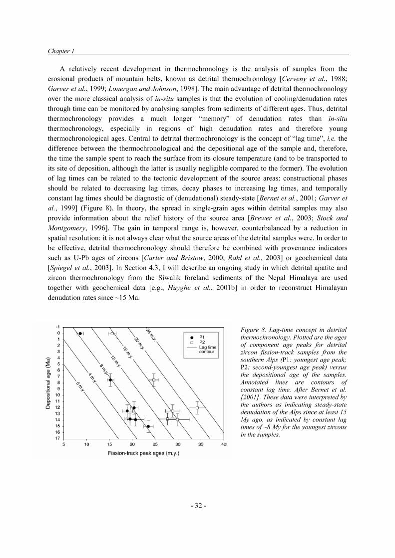
Chapter 1
- 32 -
A relatively recent development in thermochronology is the analysis of samples from the erosional products of mountain belts, known as detrital thermochronology [Cerveny et al., 1988; Garver et al., 1999; Lonergan and Johnson, 1998]. The main advantage of detrital thermochronology over the more classical analysis of in-situ samples is that the evolution of cooling/denudation rates through time can be monitored by analysing samples from sediments of different ages. Thus, detrital thermochronology provides a much longer “memory” of denudation rates than in-situ thermochronology, especially in regions of high denudation rates and therefore young thermochronological ages. Central to detrital thermochronology is the concept of “lag time”, i.e. the difference between the thermochronological and the depositional age of the sample and, therefore, the time the sample spent to reach the surface from its closure temperature (and to be transported to its site of deposition, although the latter is usually negligible compared to the former). The evolution of lag times can be related to the tectonic development of the source areas: constructional phases should be related to decreasing lag times, decay phases to increasing lag times, and temporally constant lag times should be diagnostic of (denudational) steady-state [Bernet et al., 2001; Garver et al., 1999] (Figure 8). In theory, the spread in single-grain ages within detrital samples may also provide information about the relief history of the source area [Brewer et al., 2003; Stock and Montgomery, 1996]. The gain in temporal range is, however, counterbalanced by a reduction in spatial resolution: it is not always clear what the source areas of the detrital samples were. In order to be effective, detrital thermochronology should therefore be combined with provenance indicators such as U-Pb ages of zircons [Carter and Bristow, 2000; Rahl et al., 2003] or geochemical data [Spiegel et al., 2003]. In Section 4.3, I will describe an ongoing study in which detrital apatite and zircon thermochronology from the Siwalik foreland sediments of the Nepal Himalaya are used together with geochemical data [e.g., Huyghe et al., 2001b] in order to reconstruct Himalayan denudation rates since ~15 Ma.
Figure 8. Lag-time concept in detrital thermochronology. Plotted are the ages of component age peaks for detrital zircon fission-track samples from the southern Alps (P1: youngest age peak; P2: second-youngest age peak) versus the depositional age of the samples. Annotated lines are contours of constant lag time. After Bernet et al. [2001]. These data were interpreted by the authors as indicating steady-state denudation of the Alps since at least 15 My ago, as indicated by constant lag times of ~8 My for the youngest zircons in the samples.

Scientific Context
- 33 -
1.3.2 Cosmogenic radionuclides Whereas low-temperature thermochronological data provide information on cooling and denudation rates over spatial scales of a few km and temporal scales in the order of 106 y, cosmogenic radionuclide (CRN) dating provides insights into rates of erosion on the scale of meters during 103-105 y. The two techniques are therefore very complementary.
CRN’s are produced in the top few meters of the Earth’s surface by interactions (mainly spallation and neutron capture) between cosmic rays (secondary neutrons and muons) and target atoms in the crust (Si, O, Mg, Fe, Al, Cl, K, Ca). The daughter products (CRN’s) of these reactions can be either stable (e.g., 3He, 21Ne) or decay with half-lives of a few thousand to a few million years (e.g., 10Be, 14C, 26Al, 36Cl) (cf. Bierman [1994] and Cerling and Craig [1994] for a review and background). The production rates of most CRN’s are only a few to a few 100 atoms g-1 y-1, depending on latitude and altitude; the concentrations of most CRN’s (especially the instable ones) are therefore extremely low and require very high-resolution accelerator mass spectrometers to be measured. Since the production rate of CRN’s decreases exponentially with depth below the surface, with an attenuation length of only a few tens of cm, the concentration of CRN’s records the sample’s recent history close to the Earth’s surface. CRN concentrations can be interpreted in two ways [Lal, 1991]: as indicating the exposure age of a stable surface, or as recording the near-surface erosion rate of a continuously eroding surface. Which of the two scenarios is most relevant depends on the geomorphic setting, although dual isotope analysis can be used to constrain these scenarios [Bierman and Caffee, 2002; Cockburn et al., 1999; Lal, 1991].
In situ-produced cosmogenic radionuclides are now widely used for dating geomorphic surfaces such as alluvial fans [e.g., Brown et al., 1998; Siame et al., 1997], moraines [e.g., Brook et al., 1995; E.T. Brown et al., 2002], fluvial abrasion terraces [e.g., Leland et al., 1998], marine rock platforms [e.g., Stone et al., 1996] or fault scarps [e.g., Benedetti et al., 2002]. A methodological problem arises, however, when applying the method to date constructional landforms such as alluvial fans and fluvial strath or fill terraces, because the accumulation history of cosmogenic nuclides in such settings may be highly complex. Clast inheritance prior to deposition, soil packing, stirring, aeolian deflation and inflation are some of the processes that have to be taken into account when estimating abandonment ages for such surfaces. Techniques that have been proposed to assess the inheritance component include sampling profiles of 10Be concentration with depth and amalgamating samples [Anderson et al., 1996; Perg et al., 2001; Repka et al., 1997]. In order to date strath- and fill-terraces
Figure 9. Example of profiling technique applied to date strath- and fill-terrace surfaces along western Alpine rivers. Diamonds with error bars indicate 10Be-concentration in samples taken at different depths below the surface. A large set of theoretical depth-concentration curves was generated by calculating the production from both neutrons and muons as a function of depth, randomly varying inheritance, terrace age and soil density. Models are accepted if they fit all the data points within error; curves defining maximum- and minimum-exposure ages are indicated. Best-fitting model (thick line) isdefined based on least-squares residuals. Modified from Brocard et al. [2003].

Chapter 1
- 34 -
along western Alpine rivers (cf. Section 2.3), we have developed a single-clast profiling technique, in which we estimate terrace ages and inheritance using a Monte Carlo approach [Brocard et al., 2003] (Figure 9). The degree of pedogenesis was evaluated in this study by geochemical weathering balance measurements and its effects on age scatter tested by numerical modelling. 1.4. Conclusions The realisation that tectonics, climate and surface processes interact has opened up important new research perspectives in the Earth Sciences. Surface processes play a central role in the coupling between climate and tectonics through their control on relief development. Many open questions remain concerning the interactions between and mutual controls of the different components of the system, and our present understanding of how climate and tectonics affect the rates and spatial distribution of denudation is insufficient.
Numerical surface process models (SPM’s) appear as a very useful tool to explore these interactions. However, no consensus exists on what are appropriate mathematical descriptions of the most important surface processes. Therefore, these models require continuous testing and calibration as they are being used to model the landform evolution and denudation history of specific geographic regions.
Our ability to constrain rates of denudation and landscape development has increased considerably over the last two decades through the development of low-temperature theromochronometers and cosmogenic radionuclides. The data obtained through these techniques permits us to test hypotheses concerning the controls on landscape development and can be used to calibrate and test numerical SPM’s.
In the next chapters, I will outline studies addressing these question that I have been involved in over the last 8 years as a postdoctoral research fellow at the Australian National University and as an assistant professor at Université Joseph Fourier. These studies have all involved narrow collaboration with either colleagues or with graduate students under my supervision.

Calibrating and Testing SPM’s
- 35 -
2. CALIBRATING AND TESTING SURFACE PROCESS MODELS Geomorphologists have long been searching for quantifiable measures of surface topography that can be related to tectonic activity or used to differentiate between different stages in the evolution of erosional landforms. Hypsometric (area-altitude) analyses have been developed since the 1950’s [e.g., Strahler, 1952], followed by different types of relief measurements [e.g., Ahnert, 1970; Summerfield, 1991b]. The growing availability of Digital Elevation Models during the last two decades of the 20th century have largely facilitated these analyses and the emphasis has been put on the length-scale dependence of relief through fractal measures of topography [e.g., Huang and Turcotte, 1989; Lifton and Chase, 1992].
A quantitative application of SPM’s to model the landform evolution and denudation history of specific geographic regions must overcome order-of-magnitude uncertainties in model parameters in order to be meaningful. The algorithms and parameters employed in SPM’s dictate the form and process rates predicted by the models, so that model parameters may be calibrated for a specific region by comparing model predictions of form and rate with observations. Lifton and Chase [1992], for instance, attempted to understand the controls on landform development by comparing numerical model predictions of hypsometric and fractal characteristics with observations for a region in which they expected strong variability in tectonic, climatic and lithologic forcing. Much attention has been paid recently to slope-area analyses of fluvial topography in order to constrain the parameters entering into the Stream Power fluvial incision algorithm [e.g., Kirby and Whipple, 2001; Snyder et al., 2000]. However, all of these attempts have been merely concerned with the calibration of SPM parameters, without delving into the question whether the algorithms employed actually capture the processes controlling landscape development on geological time-scales.
In this chapter, I will present the approach I have taken to calibrate the CASCADE SPM in order to model landscape development on rifted continental margins. I will then present a study in which we tested which of the fluvial algorithms described in Section 1.2.2 best captures the evolution of fluvial profiles in these tectonically quiet settings. Finally, I will present the work pursued with my PhD. student Gilles Brocard on testing and developing fluvial incision models, using western Alpine rivers in SE France as a natural laboratory. Papers pertaining to these studies are annexed as Appendices 1-4.
2.1. General calibration of SPM parameters
In order to use CASCADE to study post-break-up landscape development on the SE Australian and SE African margins (cf. Section 3.1), van der Beek and Braun, [1998; Appendix 1] attempted to constrain SPM parameter values by comparing predictions of landscape form and process rates obtained for different parameter sets with observations. Three measures of landscape form were analysed: local relief (R) is defined as the maximum elevation difference within a 10’ � 10’ window [Summerfield, 1991b], whereas the hypsometric integral (H) is calculated as:

Chapter 2
- 36 -
SdhH S��
1
0)( (14)
where h is normalised elevation ( h = h / hmax) and S is normalised surface area ( S = S / Stot). Finally, we used the variogram method to estimate the length-scale dependence of relief: the variance of elevation h(l) is calculated as a function of horizontal distance l :
� �2)()()( xlxl hhh ���
� (15)
Where the side brackets <,> indicate averaging over the study area. For a self-affine landscape, the following relation holds:
h(l) = G l(3-D) / 2 (16)
Where D is the fractal dimension and G is the roughness amplitude. We mapped the hypsometry and fractal characteristics of south-eastern Australia and found that the roughness amplitude (G) correlates well with local relief, whereas the hypsometric integral (H) correlates slightly better with elevation than with relief. The fractal dimension (D) does not correlate with any other morphometric measure and varies randomly throughout the region. We compared these finding with model predictions, using a version of CASCADE that included only hillslope diffusion and long-range fluvial transport, for models of topographic decay through plateau downwasting and escarpment retreat. The models predict that all morphometric measures evolve with time: after an initial phase where H decreases whereas D, G and R increase, all four measures decrease with increasing denudation. The behaviour of G and H in the models is qualitatively compatible with the observations; D, however, varies predictably in the models, in contrast with it’s random behaviour in the real world.
We also compiled average Cenozoic denudation rates from a review of the available data on long-term denudation in south-eastern Australia, and demonstrated a linear correlation between denudation rates and mean relief. This correlation was used to put order-of-magnitude constraints on suitable model parameter values. An independent estimate of long-term escarpment retreat rates for SE Australia provided similar constraints. Both long-term denudation rates and escarpment retreat rates predicted by the models depend much more strongly on the parameters controlling fluvial erosion and transport than on those controlling hillslope diffusion, suggesting the latter to be unimportant at the relatively coarse model resolutions employed.
These results showed that data on long-term denudation and landform evolution rates, if available, provide much tighter constraints on model parameter values then static (even if quantitative) measures of present-day morphology alone. This is because (1) the models predict that all morphometric measures evolve with continuing denudation (and thus time) and (2) the morphologic characteristics of the model landscapes are different to those observed in the real world, as exemplified by different correlations between morphometric and fractal measures. In particular, the fractal dimension behaves predictably in the models but randomly in the real-world data, indicating that we do not have a full understanding of the significance of this characteristic.
More recently, Chini [2003] used a similar approach to calibrate model parameters in a study of

Calibrating and Testing SPM’s
- 37 -
the San Gabriel Mountains (California), using both short- and long-term erosion rate data [Blythe et al., 2000, 2002b; Lavé and Burbank, submitted]. This area is better suited for such an analysis than SE Australia because (1) it is supposed to be in macro-scale topographic steady-state so that we can expect relief characteristics to be fixed through time and (2) it is made up of different blocks with widely varying uplift and erosion rates. Chini [2003] also documented a linear relationship between relief and denudation rates in this moderately active tectonic environment (denudation rates � 1.5 mm y-1), for both large-scale (block-wide) and small-scale (1 km) relief, and used this to independently constrain fluvial incision, diffusion, and landsliding parameters.
The above studies show that SPM parameters can be calibrated for a given region, with its particular tectonic, climatic and lithological controls on landform development, in a consistent manner. This does not, however, entail a validation of the model and its algorithms: even if we can find some combination of parameters that seem to make sense, this does not mean that the model itself is a correct representation of natural phenomena, for the reasons outlined in Section 1.2. In the following section, an attempt to test different algorithms for a key process in SPM’s (i.e., fluvial incision and transport) is described.
2.2. Testing fluvial incision models: An example from SE Australia
The processes of fluvial erosion and transport constitute the central ingredient of SPM’s because, in the absence of glacial processes, fluvial incision controls relief development and fluvial transport evacuates sediment out of the system. However, as we have seen in Section 1.2.2., at least five formulations describing fluvial incision have been developed and an adequate general theory for incision and sediment transport by bedrock rivers is yet to be formulated.
Fluvial long-profile forms may be used to discriminate between the various models of bedrock incision by rivers. Most studies that have used river long profiles to test bedrock incision models have assumed that incision of the rivers studied was in dynamic equilibrium with local rock uplift rates, so that the form of the fluvial profile is constant over time [e.g., Slingerland et al., 1998; Snyder et al., 2000]. However, whereas equilibrium long profiles may provide constraints on the parameter values for any particular model, they appear relatively undiagnostic in discriminating between different models [Slingerland et al., 1998; Tucker and Whipple, 2002; Whipple and Tucker, 2002]. Moreover, except in the specific conditions of sustained high rock-uplift and incision rates, rivers will generally not be in dynamic equilibrium and their forms will change over time. Studying the development of fluvial form over time after some initial disturbance may lead to significant progress in our understanding of the dynamics of, and controls on, bedrock river incision [Howard et al., 1994; Stock and Montgomery, 1999], but requires precise constraints on initial conditions and timing.
The Upper Lachlan River and its tributaries in SE Australia provide an excellent opportunity to study river long-profile development over temporal and spatial scales that are relevant to landscape-evolution models. In the Upper Lachlan catchment, widespread remnants of basalt flows, which have been mapped in detail and precisely dated [Bishop and Goldrick, 2000; Bishop et al., 1985], preserve Early Miocene river profiles that may serve as well-constrained initial conditions to test fluvial incision models. We [van der Beek and Bishop, 2003; Appendix 2] have reconstructed the Early Miocene river profiles of the Lachlan River and three of its tributaries, and used these as the starting
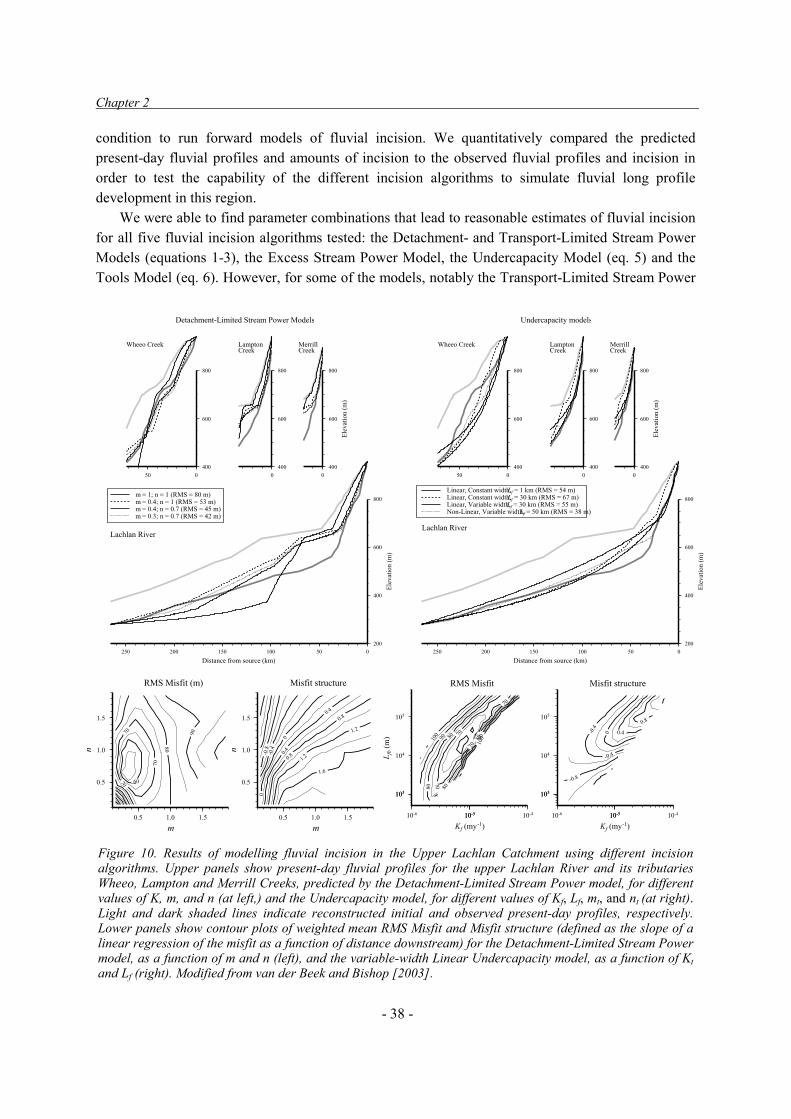
Chapter 2
- 38 -
condition to run forward models of fluvial incision. We quantitatively compared the predicted present-day fluvial profiles and amounts of incision to the observed fluvial profiles and incision in order to test the capability of the different incision algorithms to simulate fluvial long profile development in this region.
We were able to find parameter combinations that lead to reasonable estimates of fluvial incision for all five fluvial incision algorithms tested: the Detachment- and Transport-Limited Stream Power Models (equations 1-3), the Excess Stream Power Model, the Undercapacity Model (eq. 5) and the Tools Model (eq. 6). However, for some of the models, notably the Transport-Limited Stream Power
Figure 10. Results of modelling fluvial incision in the Upper Lachlan Catchment using different incision algorithms. Upper panels show present-day fluvial profiles for the upper Lachlan River and its tributaries Wheeo, Lampton and Merrill Creeks, predicted by the Detachment-Limited Stream Power model, for different values of K, m, and n (at left,) and the Undercapacity model, for different values of Kf, Lf, mt, and nt (at right).Light and dark shaded lines indicate reconstructed initial and observed present-day profiles, respectively.Lower panels show contour plots of weighted mean RMS Misfit and Misfit structure (defined as the slope of a linear regression of the misfit as a function of distance downstream) for the Detachment-Limited Stream Power model, as a function of m and n (left), and the variable-width Linear Undercapacity model, as a function of Ktand Lf (right). Modified from van der Beek and Bishop [2003].
Lachlan River
200
400
600
800
Elev
atio
n (m
)
050100150200250Distance from source (km)
m = 1; n = 1 (RMS = 80 m)m = 0.4; n = 1 (RMS = 53 m)m = 0.4; n = 0.7 (RMS = 45 m)m = 0.3; n = 0.7 (RMS = 42 m)
MerrillCreek
400
600
800
Elev
atio
n (m
)
0
LamptonCreek
400
600
800
0
Wheeo Creek
Detachment-Limited Stream Power Models
400
600
800
050
Lachlan River
Linear, Constant width,Lf = 1 km (RMS = 54 m)Linear, Constant width,Lf = 30 km (RMS = 67 m)Linear, Variable width,Lf = 30 km (RMS = 55 m)Non-Linear, Variable width,Lf = 50 km (RMS = 38 m)
200
400
600
800
Elev
atio
n (m
)
050100150200250Distance from source (km)
MerrillCreek
400
600
800
Elev
atio
n (m
)
0
LamptonCreek
400
600
800
0
Wheeo Creek
Undercapacity models
400
600
800
050
60
70
70
70
80
90
0.5
1.0
1.5
n
0.5 1.0 1.5
m
RMS Misfit (m)
-0.8
-0.4
0
0
0.4
0.4
0.8
0.8
1.2
1.2
1.6
0.5
1.0
1.5
n
0.5 1.0 1.5
m
Misfit structure RMS Misfit Misfit structure
103103
104
105
L fb (
m)
10-6 10-510-5 10-4
Kf (my-1)
70
70
70
70
80
80
80
8090 9010
0
100
103103
104
105
10-6 10-510-5 10-4
Kf (my-1)
-0.8
-0.4
-0.4
0 0.4
0.8

Calibrating and Testing SPM’s
- 39 -
model and non-linear versions of the Undercapacity and Tools models, these parameter combinations appear to have no physical significance, since best-fit values of the mt and nt exponents in Equation (2) are incompatible with their theoretical values based on either stream power, unit stream power, or basal shear stress descrption (cf. Section 1.2.2). For some models the best-fit parameter combinations are such that these tend to mimic other models: best-fit Excess Stream Power models have vanishingly small thresholds so that they behave as simple Detachment-Limited Stream Power models; best-fit Tools models and uniform-width Undercapacity models are characterised by an incision length scale Lf close to the model grid spacing so that they behave as Transport-Limited Stream Power models. Of the five algorithms tested, the Detachment-Limited Stream Power model and the linear Undercapacity model appear to describe fluvial incision best (Figure 10). The latter model, however, needs to include a river width term that varies as a function of drainage area.
The uncertainty in initial conditions does not strongly influence the model outcome. Using initial conditions that maximize the required amount of incision lead to parameter values that are approximately 1.5 times higher than those for a more conservative estimate of incision. There are, however, large differences between the different streams we studied, which appear to be related to lithological variation. Models including lithological variation along the different streams provide much better fits to the data than single-lithology models and involve 3-5 fold variations in parameter values for the different lithologies.
A quite similar analysis has recently been performed by Tomkin et al. [2003] for the Clearwater River in the Olympic Mountains (NW USA). The major difference between the two study areas is that the Clearwater River is believed to be in dynamic equilibrium [Pazzaglia and Brandon, 2001] whereas the Lachlan clearly is not. Also, long-term incision rates are two orders of magnitude larger in the Clearwater than in the Lachlan. Tomkin et al. [2003] tested whether best-fit parameter combinations for the five incision models also tested here, plus an alternative ‘sediment-limited’ model, were physically plausible (as expressed by m / n ratios that conform to theory) and found that none of the models they tested provided an adequate fit. Our findings are somewhat more optimistic than Tomkin et al.’s in that at least some models or model combinations appear to describe long-term incision in the Lachlan catchment reasonably well.
Although the Detachment-Limited Stream Power model predicts the best-fitting incision profiles of all the models we tested, it has a conceptual weakness in that it predicts that rivers will always incise. In SPM’s the problem may be circumvented by combining Detachment-Limited and Transport-Limited Stream Power algorithms, with the one that predicts the lowest incision being taken as the rate-limiting process [e.g., Densmore et al., 1998; Tucker and Slingerland, 1994; Whipple and Tucker, 2002]. Alternatively, “hybrid” formulations such as the Undercapacity model implicitly predict transitions from detachment- to transport-limited behaviour to take place along the streams. The location and abruptness of this transition depends on Lf. The use of combined Detachment- and Transport-Limited models has led to the notion that many rivers may be at a ‘threshold’ in that they are exactly adjusted to transport their sediment load in equilibrium conditions, but their transient response to base-level drops is detachment-limited. Whipple and Tucker [2002] showed how such threshold rivers would operate theoretically. In the following, I will provide evidence that western Alpine rivers indeed demonstrate such behaviour, and use these observations to propose a conceptual model for fluvial incision and transport.

Chapter 2
- 40 -
2.3. A conceptual model for river incision based on observations in western Alpine rivers In order to explore the influence of incision rate, rock strength and bedload supply on bedrock river morphology, Gilles Brocard has studied the behaviour of rivers located in the French western Alps. The western Alps are an ideal area for such analyses, because they are characterised by constant and moderate tectonic uplift rates but rivers have strongly varying incision rates due to differences in glacial disruption of catchments, both equilibrium and disequilibrium rivers occur, and the area has locally strongly variable but regionally homogeneous bedrock.
2.3.1. Controls on incision rates in western Alpine Rivers
The Alps are a moderately active orogen; present-day geodetically-derived rock uplift rates [Jouanne et al., 1995; Martinod et al., 1996], and long-term denudation rates from thermochronology [Bernet et al., 2001; Bigot-Cormier et al., 2000; Seward et al., 1999] are both on the order of 0.5-1.0 mm y-1. The western Alps experienced widespread glaciations during the Pleistocene, which left varying imprints on the present-day fluvial landscape. In the investigated area (Figure 11), glaciers coming from the Internal Alps during glacial periods were not large enough to reach the foreland, and were diverted by north-south trending structures. Their influence therefore decreases westward. To the East, rivers like the Drac and its tributaries were partly invaded by ice streams that strongly modified their long profile [Brocard et al., 2003 and submitted; Montjuvent, 1973]. To the West, valleys remained ice-free during glaciations.
Incision rates have been measured along two of the largest rivers in the study area, which have constructed numerous terraces during the Pleistocene, by cosmogenic 10Be dating of these terrace levels, using the techniques outlined in Section 1.3.2 [Brocard et al., 2003; Appendix 3]. Of these
Figure 11: Shaded relief image of the study region in SE France, showing location of main rivers, dated terraces and major neotectonic features. The relief of the subalpine massifs (e.g., Chartreuse, Vercors, Digne Thrust sheet) is controlled by thin but resistant units of massive limestones (Tithonian, Barremian, Campanian) that core the topographic ridges in the area. The city of Grenoble is located at the confluence of the Drac and Isère rivers. After Brocard et al. [2003].

Calibrating and Testing SPM’s
- 41 -
rivers, the Drac was most strongly affected by glacial advances. During each advance stage, a series of glaciers dammed the river valley. Fill terraces were built upstream from these ice-dams and were abandoned after retreat of the glaciers [Montjuvent, 1973]. The Drac River then entrenched the fill deposits and underlying bedrock, carving out cut-fill and strath terraces. Post-glacial incision in the Drac River is controlled by retreating knickpoints (Figure 12a): at a site located ~15 km upstream of the major glacier dam, incision began several thousand years after the inception of glacial retreat and occurred at a rate greater than 60 mm y-1 during less than 5 ky before dropping to 8-11 mm y-1 over the last 7 ky. A degraded unstable knickpoint occurs in the present-day long profile of the Drac River; downstream of this knickpoint, river incision rates are significantly higher (7.4±1.0 mm y-1) than upstream (4.6±0.7 mm y-1). This knickpoint is interpreted as being the remnant of the initial glacially oversteepened reach that migrated ~55 km upstream during the Holocene.
The Buëch represents a river whose long profile has not been modified, but whose regime and bedload characteristics have been influenced by the meltwater contribution of large glaciers located in its upper catchment [Brocard et al., submitted]. The glacially increased discharge and sediment flux led to the formation of paired terraces that are covered with river sediments deposited during cold periods [Mandier, 1984]. The Buëch River preserves three terrace levels, whose treads stand 20, 80, and 190 m above the present-day valley floor, and which have been dated at ~7.5, <60, and ~190 ky, respectively (Figure 12b). A comparison of these terrace ages indicates that the incision rate of the Buëch River fluctuates with climate changes but is roughly constant when integrated over periods longer than the mean duration of the glaciations; approximately 0.8 mm y-1 over the last 200 ka. The spatial and temporal continuity of incision rates along the Buëch River, as well as the fact that these
Figure 12. Present-day long profiles, terrace levels, ages and inferred long-profile development for the Drac River (a) and the Buëch River (b). Also indicated are the maximum glacial advances and their probable ages. After Brocard et al. [2003].
A) Drac River
B) Buëch River

Chapter 2
- 42 -
rates are close to both present-day rock uplift rates [Jouanne et al., 1995; Martinod et al., 1996] and long-term denudation rates [Bernet et al., 2001; Bigot-Cormier et al., 2000; Seward et al., 1999], suggests that the Buëch may be in dynamic equilibrium over 105 y timescales. The cosmogenic data indicate that the Drac River, which was pushed out of equilibrium during Quaternary glaciations, incises bedrock at a rate an order of magnitude faster than the Buëch and Drôme rivers, whose profiles were not influenced by the Last Glaciation.
2.3.2. Influence of incision rate, rock strength and bedload supply on bedrock river gradient and
valley-flat width
The strongly varying incision rates between rivers in a region that is otherwise (tectonically, lithologically and climatically) homogeneous allow us to single out the influence of different controlling parameters (i.e. incision rate, rock strength, bedload supply) on river incision. To do this, a systematic analysis of fluvial forms in the western Alps was undertaken, focusing on three major rivers (the Drac, Buëch and Drôme) as well as several tens of smaller streams draining the region south of the Drôme River (Figure 11) [Brocard and van der Beek, submitted; Appendix 4]. All these rivers flow across folded sedimentary rocks with strongly contrasting rock strengths.
The analysis shows that slowly-incising “equilibrium” streams in our study area are detachment-limited in their upstream reaches, with a transition to transport-limited behavior downstream. The Drac River, which incises an order of magnitude more rapidly because it has been pushed out of equilibrium during glaciations, shows an inverse pattern: it is transport-limited upstream of a retreating knickpoint, which represents the present-day limit to where postglacial base-level drop has been communicated up the river, and detachment-limited downstream. Observations and characteristics that permit to distinguish between transport-limited and detachment-limited behavior include the channel morphology, river gradients, the occurrence or absence of lithological knikpoints and the development of a valley flat. The latter two characteristics are the most diagnostic: within detachment-limited reaches, rivers react to variations in bedrock strength by adjusting their gradient, whereas in transport-limited reaches, they react by adjusting their valley-flat width.
By mapping out the occurrence of knickpoints, we have constrained the critical area for the transition from detachment-limited to transport-limited behavior, and have quantified the influence of rock strength and incision rates on the location of this transition. We cannot resolve the form of the transition with sufficient resolution to discriminate between simple stream power models (that would predict a sharp transition) and more elaborate sediment-flux dependent incision models (that predict a gradual transition). The data do allow us, however, to make estimates for model parameter values for a combined detachment- and transport-limited river incision model [Whipple and Tucker, 2002], the simplest model that is both testable and consistent with our data. These estimates are in general agreement with earlier results using different approaches [e.g., Snyder et al., 2000; Stock and Montgomery, 1999; van der Beek and Bishop, 2003].
Although the concordance between these independent studies is promising, two discrepancies require an explanation. Firstly, why do detachment-limited conditions appear much more widespread in the Lachlan catchment (as shown by the persistence of lithological knickpoints up to drainage areas of at least 1000 km2 and the relatively good performance of a simple detachment-limited stream power model in predicting incision) than in the western Alps, whereas incision rates in the Lachlan

Calibrating and Testing SPM’s
- 43 -
catchment are at least two orders of magnitude lower than in the Alpine rivers? Secondly, the two-orders-of-magnitude difference in estimated K values between these two studies seems suspiciously large. The difference in lithology underlying both study areas (calcareous sediments in the western Alps; granites and metasediments in the Lachlan catchment) will undoubtedly have an effect on K; the direction of change matches a-priori expectations (i.e., the Lachlan catchment is underlain by harder bedrock than the western Alpine rivers). An alternative explanation for large variations in K values between areas with different incision rates could be the presence of erosion thresholds and a stochastic distribution of flood events, as recently proposed by Snyder et al. [2003]. This effect could be tested in the Alpine rivers by numerical modelling of incision in the Drac River versus the more slowly incising rivers. In any case, the significantly lower K values for the Lachlan River compared to the western Alpine rivers would promote detachment-limited behaviour. Moreover, there is a significant difference in bedload caliber in that the Lachlan River only carries sand. This much finer bedload (in comparison with the western Alpine rivers) will require much lower transport-limited slopes and therefore promote detachment-limited conditions.
An important aspect of our model is the behaviour of transport-limited streams: their gradients are set by bedload supply and caliber, and are not directly influenced by bedrock strength or incision rate. There is, however, an indirect control of these parameters on transport-limited gradients through the dependence of the caliber of bedload that is delivered to the streams on rock type and erosion rate. We have shown that transport-limited rivers respond to variations in rock strength and incision rate by adjusting their valley-flat widths in a predictable and quantifiable manner. The emerging view of a drainage net consisting of both detachment-limited and transport-limited reaches, in which transport-limited rivers are relatively insensitive to variations in rock strength and uplift rates, has important implications for river incision models as well as the inferred coupling between uplift / incision rates and river profiles in equilibrium settings. 2.4. Conclusions Numerical Surface Process models require rigorous testing and calibration of their controlling algorithms in order to be used with confidence in exploring the controls on the morphological development of specific regions. However, it is not clear what landscape properties can be used to test model predictions. I have shown (Section 2.1) that present-day morphometric measures, other than local relief, have limited value because these measures either correlate strongly with relief or vary unpredictably. Data on long-term denudation rates and relief can be used to calibrate model parameters in a consistent manner. However, such a calibration does not entail a validation of the model algorithms.
Progress has been made in understanding how to model fluvial incision, the key process in shaping relief in non-glaciated settings. Two independent studies (Sections 2.2. and 2.3) both suggest that river incision algorithms need to take sediment flux into account, either by combining detachment-limited and transport-limited descriptions of fluvial incision, or by using hybrid formulations, such as the Undercapacity or Tools models.
The conceptual model that starts to emerge from these studies has important implications for river incision models as well as the coupling between uplift / incision rates and river profiles in equilibrium settings.

Chapter 3
- 44 -
3. USE OF SURFACE PROCESS MODELS TO UNDERSTAND TECTONICS – SURFACE PROCESS INTERACTIONS
In parallel with the efforts to calibrate numerical SPM’s and to assess the validity of their basic algorithms, I have also been using the CASCADE SPM in order to gain insights into the controls on landscape evolution in different tectonic settings. In this chapter, I will briefly review these studies, concentrating first on work, initiated during my post-doctoral fellowship at ANU, that aimed at understanding the controls on post-break-up landscape development at rifted continental margins. Subsequently, I will outline the work I have been doing over the last few years with my PhD. student Bénédicte Champel-Duffait on the Himalayan mountain front in Nepal, as well as ongoing work by Bénédicte that attempts to couple the SPM to dynamic models of crustal deformation. 3.1. Post-break-up landscape development at rifted continental margins Great escarpments along high-elevation rifted continental margins are some of the most prominent morphological features on Earth. During the past decade, the importance of understanding the factors controlling escarpment evolution, in order to comprehend better the dynamics of rifted margins, has become increasingly appreciated by geologists and geophysicists [e.g., Beaumont et al., 2000; Gilchrist and Summerfield, 1990, 1994; van der Beek et al., 1995]. At the same time, the geomorphological community has shown a renewed interest in large-scale, long-term landscape development of rifted margins and other intra-plate settings [e.g., Summerfield, 2000].
Over the past decade, the development of apatite fission-track thermochronology [e.g., Bohannon et al., 1989; Brown et al., 1990; Gallagher et al., 1994 and many others] and, more recently, cosmogenic isotope analysis [Bierman and Caffee, 2001; Cockburn et al., 2000; Fleming et al., 1999; van der Wateren and Dunai, 2001], has contributed significantly to quantifying the denudational history of rifted margins. These data are in many cases incompatible with traditional paradigms for the evolution of such margins, which explained the observed morphology in terms of pulses of uplift and escarpment retreat [e.g., King, 1962; Ollier, 1985]. The new data and models have led to the realization that the geomorphic evolution of escarpment systems may be considerably more complex and variable [Brown et al., 2000; Gallagher and Brown, 1997; Gilchrist and Summerfield, 1994].
Numerical SPM’s have been used from the early stages of their development to study rifted margins. Early, two-dimensional models have demonstrated the importance of denudation and resulting isostatic rebound in generating, maintaining, and modifying the morphology of rifted margin upwarps [Gilchrist and Summerfield, 1990; ten Brink and Stern, 1992; van der Beek et al., 1995]. More sophisticated, planform, SPM’s have been employed to investigate both the conditions that are necessary to generate and maintain escarpments on high-elevation rifted margins [Kooi and Beaumont, 1994; Tucker and Slingerland, 1994], as well as the controls exerted by factors such as lithology and pre-break-up morphology on the subsequent evolution of such margins [Gilchrist et al., 1994; Kooi and Beaumont, 1994, 1996]. Studies that have attempted to address the geomorphic evolution of a particular margin have been rare, however. Over the past few years, I have been using CASCADE to assess the post-break-up development of the southeastern African (Drakensberg

SPM’s and Tectonics – Surface Process Interactions
- 45 -
Escarpment) and southeastern Australian margins, two of the best studied escarpment systems in the world.
3.1.1. The southeastern African (Drakensberg Escarpment) margin
The southeastern African margin was formed by oblique opening of the Natal Basin about 130 My ago. The morphology of southeast Africa is characteristic of a high-elevation rifted margin, with a prominent erosional escarpment (the Drakensberg Escarpment) separating the high-standing continental interior (the Lesotho Highlands) from a strongly dissected coastal region. We [van der Beek et al., 2002b; Appendix 5] have studied the controls on post-break-up landscape development and the denudational history of the Drakensberg Escarpment, using a numerical surface processes model.
In a companion study [R.W. Brown et al., 2002], the spatial and temporal patterns of post-break-up denudation along a transect across this margin were documented using apatite fission-track data derived from both surface and deep borehole samples. These data, together with recent estimates of short-term rates of downwearing and escarpment retreat from cosmogenic isotope analyses [Fleming et al., 1999], are incompatible with traditional views on the evolution of the Drakensberg
100 Ma
Plateau Degradation
60 Ma
Present-day
0
50
100
0
100
200
12
Escarpment Retreat
0
50
100
0
100
200
12
Figure 13. Artificially illuminated oblique views of the topography and drainage patterns predicted by Plateau Degradation and Escarpment Retreat models, at 100 Ma, 60 Ma and the present-day. Axes indicate model coordinates in kilometers. Parameter values for these models are chosen so that the present-day position of the escarpment matches the position of the Drakensberg Escarpment (~150 km from the coast) in both models. After van der Beek et al. [2002b].

Chapter 3
- 46 -
Escarpment. According to these ‘classic’ views, the Drakensberg Escarpment evolved through parallel retreat from an initial location at the coastline and was “rejuvenated” since Miocene times as a result of major surface uplift [King, 1962; Ollier and Marker, 1985; Partridge and Maud, 1987]. R.W. Brown et al. [2002] proposed an alternative model of landscape development, in which an escarpment was initiated at the coast but was then rapidly destroyed by rivers flowing from an interior drainage divide. This divide would have existed at a local high on the Karoo basalt plateau just seaward of the present-day Drakensberg Escarpment.
Numerical modeling results support this conceptual model for the post-break-up geomorphic development of the southeast African margin and show how, in the presence of a pre-existing drainage divide, a new escarpment forms at the locus of the drainage divide several tens of millions of years after break-up, and subsequently slowly retreats (Figure 13). These models shed light on the major factors controlling post-break-up landscape evolution on rifted margins. The pre-break-up topography of the margin appears to exert a fundamental control; models which include a pre-existing drainage divide evolve by rapid degradation of the plateau surface seaward of the divide, whereas models without a pre-existing drainage divide evolve by parallel escarpment retreat. Secondary controls are exerted by the flexural rigidity of the lithosphere, lithological variation in the eroded upper crustal section, and inland base level falls. Lithological variations lead to the establishment of flat-topped ridges extending out from the escarpment as well as major knickpoints on rivers. Both these features have previously been interpreted as confirming Cenozoic surface uplift of the margin.
Two key elements of our model contradict previous hypotheses for the evolution of the southeast African margin, based on the interpretation of erosion surfaces: (1) the escarpment has experienced only limited retreat since break-up, and was therefore initiated close to its present-day position rather than at the shoreline or the shelf edge; and (2) no large-scale Cenozoic tectonic surface uplift is required to explain the morphology and denudation history of the southeast African margin
3.1.2. The southeastern Australian margin
The tectonic and geomorphic evolution of the southeastern Australian highlands has been a subject of controversy among geophysicists, geologists and geomorphologists for several decades. For the better part of the 20th century, the evolution of the southeastern highlands has been cast in “Davisian” terms of cyclical landscape evolution. In such a scenario, the highlands were thought to have originated by a Pleistocene phase of uplift affecting a pre-existing peneplain that had formed close to sea-level. This uplift was also held responsible for widespread recent drainage capture that was interpreted from the complicated river patterns observed in southeastern Australia. The 1970's and 80's saw a gradual but nearly complete move away from these concepts, as evidence for the considerable antiquity of parts of the highlands' morphology mounted [cf. Bishop and Goldrick, 2000 for a review]. The culmination of the turnaround in thinking about the evolution of the southeastern highlands may have been the publication of a model by Lambeck and Stephenson [1986], in which the highlands were considered to be the erosional remnant of a much larger Paleozoic orogen, evolving since that time primarily through erosional downwasting and isostatic rebound. Nearly simultaneously with the publication of the Lambeck and Stephenson [1986] model, however, the results of large-scale palaeogeographical and fission-track thermochronological studies were

SPM’s and Tectonics – Surface Process Interactions
- 47 -
published [Dumitru et al., 1991; Jones and Veevers, 1983; Moore et al., 1986], which suggested a strong influence of tectonic events related to the opening of the Tasman Sea on the evolution of the highlands.
van der Beek et al. [1999; Appendix 6] presented SPM simulations of large-scale, long-term landscape development in southeastern Australia in order to address the controversies surrounding the highlands’ morphological and denudation history; their uplift history, denudation rates, the depth of denudation of the coastal strip and inferred Mesozoic drainage patterns. These initial modelling results showed that the history of denudation and drainage development of southeastern Australia can be explained to a first order without invoking large-scale mid-Cretaceous or Tertiary uplift events. The geomorphology and available fission-track data in the higher-elevation and -relief Snowy and Blue Mountains regions, in contrast, do require renewed (mid-Cretaceous?) uplift to have taken place. The modelling results predict 1.5-2 km of post-mid-Cretaceous denudation on the coastal plain, an amount that is consistent with the fission-track data from that region if late Mesozoic-early Cenozoic geothermal gradients were significantly higher than at present. Finally, our model results highlighted the possibility of extreme temporal and spatial variability in denudation rates and appear to be consistent with both the fission-track and the geomorphic data on denudation rates. Much of the controversy concerning amounts and rates of denudation in southeastern Australia therefore appears to have arisen from unwarranted extrapolation or comparison of data.
In a more detailed study of the post-break-up evolution of the escarpment system [van der Beek and Braun, 1999; Appendix 7], we assessed the controls on landscape development using a similar approach as that for southern Africa, and constraining fluvial incision parameters by fitting southeast Australian river profiles. As for southern Africa, the model results showed that the initial (pre-break-up) topography of the highlands provides a fundamental control on their subsequent evolution, together with the style and rate of fluvial incision. Our models indicate that at least part, and possibly all, of the present-day elevation of the southeastern highlands was present before the onset of rifting in the Tasman Sea. The results also provide insights into the style of uplift that affected southeastern Australia: a model of rift flank uplift, as advocated previously by Weissel [1990] and van der Beek et al. [1995], appears inconsistent with the observed landform development in southeastern Australia, specifically with the location of the drainage divide inland of the escarpment, as does an alternative model of downwarping of the coastal plain during rifting [Ollier and Pain, 1997]. The only pre-break up topography that evolves into the currently observed morphology of the margin is one of a high-elevation plateau sloping gently seaward from a pre-existing drainage divide. Again, as in southern Africa, our models cast serious doubt on the role of escarpment retreat in the post-break-up evolution of rifted continental margins. Most of our models show very limited retreat of the escarpment, which does not originally form at the locus of base-level drop but at some distance inland, controlled by local rates of river incision and isostatic rebound. Once an escarpment is formed, it does not retreat regularly but forms embayments around the major rivers where it becomes a ‘gorge-like’ escarpment, leaving behind the parts in between as ‘drainage-divide’ escarpments.
Finally, we have zoomed in on Cenozoic landscape development in the Blue Mountains region using both field observations and numerical models [van der Beek et al., 2001; Appendix 8]. In many parts of the southeast Australian highlands, Eocene-Miocene basalts flowed down paleo-valleys, indicating that landscape dissection was already well underway at the time of their eruption [Bishop and Goldrick, 2000 and references therein]. Within the deeply incised Blue Mountains, however, Miocene basalts cap relatively flat hill-tops, suggesting that most incision post-dates their

Chapter 3
- 48 -
emplacement. Geochemical data and K-Ar geochronology indicate that the Blue Mountains basalts were derived from a common source and were erupted in a relatively short time span. We have mapped the Blue Mountains basalts in detail to reconstruct the Miocene landscape and to quantify both the amount of sub-basalt relief and post-basalt incision rates. Sub-basalt relief is remarkably gentle: it does not exceed 100 m for any single basalt cap and is of the order of 200 m for the entire region. This contrasts sharply with a present-day relief of up to 700 m in major river gorges. We explain the dramatic post-Miocene increase in regional relief by migration of major knickpoints up the river gorges, with retreat rates estimated at 800-1200 m My-1. The kinematics of post-break-up knickpoint retreat thus plays a fundamental role in modifying rifted margin morphology. The Blue Mountains are bounded to the east by the Lapstone Structural Complex (LSC), a major faulted monocline that locally forms the present-day escarpment. Extrapolation of the estimated retreat rates suggests that knickpoints were initiated on this structure between 48 and 71 Ma. The Blue Mountains escarpment has been interpreted to result from either early Tertiary movement on the LSC or from passive exhumation of previously tilted resistant sandstones at the monocline. We employed the CASCADE SPM to explore these two hypotheses and conclude that, although lithological control cannot be excluded, early Cenozoic uplift, related to variations in intraplate stresses and/or magmatic underplating, appears to have been a major factor in shaping the anomalous morphology of the Blue Mountains region. This study reveals that significant lateral variation may exist in the morphologic development of rifted margins, and that local lithological and tectonic factors may interact in a complex manner to produce such variation. 3.2. Controls on drainage development at active mountain fronts: the Himalayas of central
Nepal Understanding the processes that control drainage development on tectonically active structures is important, because drainage patterns may be used to establish the presence and activity of blind thrusts and may thus provide valuable information for seismic risk assessment [Boudiaf et al., 1998; Keller et al., 1999]. Moreover, the initial tectonic growth phase is a key event that controls long-term drainage patterns in collisional mountain belts [Gupta, 1997; Oberlander, 1985]. Distinctive geomorphic features of active thrust-related fold growth include the diversion of pre-existing transverse rivers from an axial course and the development of a series of wind gaps at the loci of antecedent transverse streams [e.g., Burbank et al., 1999; Jackson et al., 1996]. The decrease in elevation of wind gaps, together with a decrease in relief and drainage density of the active fold crest, may indicate the direction of lateral fold propagation [Keller et al., 1999] and, in principle, be used to constrain rates of fold propagation [Jackson et al., 2002; Tomkin and Braun, 1999]. Antecedent rivers that have sufficient erosive power to cut through the uplifting ridge will evolve into transverse streams, which often show a characteristic spacing [Jackson et al., 1996; Tomkin and Braun, 1999].
Drainage patterns in the Nepal Himalaya are remarkable in that numerous large rivers are deflected along the traces of the major thrusts [Gupta, 1997]. Along-strike river offsets between the deformation front and the internal thrusts, as well as the spacing of rivers that cross the frontal ridge, display distinctive regional variations (Figure 14). In western Nepal, several rivers are deflected for over 100 km by the most external ridge. In contrast, maximum deflection is only 37 km in central and

SPM’s and Tectonics – Surface Process Interactions
- 49 -
eastern Nepal. These differences are not readily explained by differences in uplift rate on the frontal fold, which are practically constant along-strike [Lavé and Avouac, 2000; Mugnier et al., 2003], nor by differences in bedrock erodibility or stream power.
We have coupled the CASCADE SPM to a kinematic description of fault-propagation and fault-bend folding [Suppe, 1983; Suppe and Medwedeff, 1990], in order to study the controls on drainage development in the frontal Nepal Himalayas [van der Beek et al., 2002a; Champel et al., 2002; Appendices 9 and 10]. Our model shows the fundamental control on drainage development exerted by the dip of the detachment underlying the folds (Figure 15). When the detachment is horizontal, the relative rates of tectonic uplift and fluvial incision control the evolution, in agreement with conceptual models [Burbank et al., 1999; Jackson et al., 1996; Tomkin and Braun, 1999]. For a non-zero dip, in contrast, the lateral displacement gradient associated with fold propagation sets up a lateral slope behind the active structure, which deflects the stream network. In this case, the characteristic fault-segment length, rather than the relative rates of fold uplift and incision, may control the spacing of transverse streams. From the results of our modeling, we suggest that the major control on the difference in drainage patterns observed between western and central Nepal is the dip of the detachment [van der Beek et al., 2002a]. Independent estimates of the detachment dip, from flexural models [Lyon-Caen and Molnar, 1985], balanced cross-sections [Lavé and Avouac, 2000; Mugnier et al., 1999b] and geodetic data [Jackson and Bilham, 1994; Jouanne et al., 1999; Larson et al., 1999] suggest that this dip varies from 1.5°–3° in eastern Nepal to 4.5°–8° in western Nepal, with a transition zone located near long. 84°E. To a first order, these variations support our model inferences that drainage patterns are strongly controlled by the dip of the underlying detachment (Figure 14).
In a subsequent more in-depth analysis [Champel et al., 2002], we applied our model to the Dundwa fault-related fold ridge in western Nepal and demonstrated the importance of landsliding for the attainment of realistic and steady-state topography (cf. discussion in Section 1.2.3). Using structural markers and balanced cross-sections, we estimate a remarkably low mean propagation rate
Figure 14. Simplified structural and drainage map of Nepal Himalaya (top panel), showing major thrusts (MCT—Main Central thrust, MBT—Main Boundary thrust, MDT—Main Dun thrust, MFT: Main Frontal thrust), fault-propagation folds (arrows), rivers (S: Surai; T: Tinau), and Quaternary piggy-back basins. Large arrows with numbers indicate Holocene convergence rates [after Lavé and Avouac, 2000; Mugnier et al., 2003]. Lower Panel: River spacing (upward y-axis) and diversion (downward y-axis: white—at Main Frontal thrust, shaded—at Main Dun thrust) for streams traversing the Siwaliks, as a function of longitude. Inferred dip of the Main Himalayan detachment after Larson et al. [1999]. Modified from van der Beek et al. [2002a].
S T

Chapter 3
- 50 -
for different segments of the structure. This finding, together with the structure and morphology of the ridge, leads us to propose that the ridge developed by linkage of several component segments. The drainage evolution predicted when modeling this scenario compares favorably with field observations. We conclude from these studies that drainage patterns on fault-related fold ridges may be controlled by fault geometry (detachment dip and characteristic segment length) rather than by the relative rates of tectonics and surface processes and, as a result of fault segment linkage, estimates of propagation rate of these structures may be strongly scale-dependent. 3.3. Toward coupled tectonics – surface process models of active mountain fronts Whereas the models for rifted margin development described in Section 3.1 contained some coupling between tectonics and surface processes through the isostatic response of the lithosphere, the above models of drainage development at mountain fronts were based on purely kinematic models of deformation. As part of her PhD. Thesis, Bénédicte Champel has developed and used coupled models to study landform evolution in the Nepal Himalaya at two different scales: the foreland fold-and-thrust belt and the entire range. 3.3.1. Development of foreland-fold-and-thrust belts The interaction between erosion and tectonics may be most obvious at the intermediate scale of foreland-fold-and-thrust belts, as suggested by field observations [e.g., Pavlis et al., 1997; Strecker et al., 2003] and analog models [e.g., Malavieille, 1984; Mugnier et al., 1997]. Critical wedge theory predicts that surface transport of material will affect the internal deformation of accretionary wedges [Dahlen, 1990; Dahlen and Suppe, 1988], to which foreland-fold-and-thrust belts may be assimilated. Several models of fault activity and wedge growth influenced by erosion have been developed, in Grenoble and elsewhere, in recent years [Chalaron et al., 1995, 1996; Hardy et al., 1998; Mugnier et al., 1999a], but these have modelled surface transport by diffusion only and, with the exception of the models by Chalaron et al. [1995, 1996], were two-dimensional.
Elevation (km)
x (k
m)
10
20
30
x (km)
1020 1020y (km)
1020
Horizontal DetachmentSlow Convergence
� = 0; Vt = 2 mm y-1
Horizontal DetachmentFast Convergence
� = 0; Vt = 20 mm y-1
Dipping DetachmentFast Convergence
� = 5°; Vt = 20 mm y-1
0 0.2 0.4 0.6 0.8 1.0 1.2
Figure 15. Maps of model topography and drainage for various convergence rates(Vt) and detachment-fault dips (�). A: Slow convergence rate and a flat detachment, after 250,000 yr. B: Fast convergence rate and a flat detachment, after 150,000 yr. C: Dipping detachment, after 150,000 yr. Modified from van der Beek et al. [2002a]

SPM’s and Tectonics – Surface Process Interactions
- 51 -
We are developing a coupled three-dimensional model for the development of thrust wedges, based on CASCADE, in order to study possible climatic controls on thrust propagation and wedge width. The impetus for this work is the observation that the Himalayan fold-and-thrust belt (the Siwalik hills) displays significant lateral variations in structure [Chalaron et al., 1995; Duncan et al., 2003]: whereas it is ~40 km wide and comprises three or four thrust slices in western Nepal, it narrows toward the east to <10 km and a single thrust slice in Bhutan (cf. Figures 14 and 17). Chalaron et al. [1995] suggested that this difference may be linked to a westward decreasing erosional efficiency, related to the diminishing influence of the monsoon: precipitation rates are ~1000 mm y-1 to the west of Nepal and approximately twice that to the east (data from WMO and Indian Meteorological Department websites).
Coupling between surface processes and wedge kinematics is accomplished through a minimum-work approach [Hardy et al., 1998; Masek and Duncan, 1998]: the wedge is divided into a number of thrust slices and, at each time-step, the total work required to accommodate shortening on each of the thrusts is calculated. Total work is the sum of (1) gravitational work required to push material up the thrust ramp, (2) frictional work required for sliding over the ramp, and (3) work required for internal deformation of the thrust slice. The thrust that minimizes the total work is the one that will accommodate the shortening for that time step. The surface-process model is the same as that developed to study active folds (cf. previous section).
Initial modelling results demonstrate the importance of surface processes for the development of thrust wedges (Figure 16). Including efficient mechanisms for erosion and surface transport of material leads to a significant decrease in the frontal propagation rate of the wedge. In the example shown in Figure 16, the frontal thrust is activated after ~200 ky for a model with local sediment
Figure 16. Results of coupled tectonic – surface process model for thrust wedges: predicted surface topography after 200,000 y of shortening at a rate of 20 mm y-1 for a model including diffusion only (A) and a model including landsliding and fluvial erosion and transport (B). C) Predicted fault activity through time for these two models (in red, diffusion only; in green, landsliding + fluvial transport).

Chapter 3
- 52 -
transport through diffusion only, whereas the activation of the frontal thrust is delayed to >300 ky for a model including landsliding and long-range fluvial transport. These initial model results are therefore in qualitative agreement with the working hypothesis that the efficiency of erosional processes directly influences the evolution of a thrust wedge. Bénédicte is currently performing sensitivity analyses in order to make more quantitative predictions. 3.3.2. Crustal-scale models of tectonics and erosion in the Himalaya Important lateral variations occur in the structural and morphologic characteristics between the central and eastern Himalayas of Nepal and Bhutan, respectively [e.g., Duncan et al., 2003] (Figure 17). Topographically, the Nepal Himalaya is characterized by a concave cross-sectional topography with maximum relief restricted to the topographic front of the High Himalaya. In Bhutan, in contrast, the cross-sectional topography is convex, and high relief is encountered over a much wider zone. Geologically, besides the lateral variations in the width of the Siwalik thrust belt already noted, the Nepal Himalaya is characterized by widespread outcrops of Lesser Himalayan rocks, which are only locally covered by erosional remnants (klippen) of High Himalayan crystalline rocks, whereas the latter unit is much more widespread in Bhutan. A comparison of geochemical fluxes in the Ganges and Brahmaputra drainage basins [Galy and France-Lanord, 2001] suggest present-day denudation rates to be higher in the eastern Himalaya, compared to the central and western Himalaya, in qualitative accord with the higher precipitation rates in the East due to the stronger influence of the monsoon.
In order to test whether these lateral climatic, geomorphic and structural variations might be linked, Bénédicte has used a two-dimensional dynamic model of tectonic deformation, coupled to a model of fluvial erosion at the surface [Batt and Braun, 1997, 1999]. The initial model geometry contains a thickened plateau (Tibet) passing laterally into normal thickness (Indian) continental crust. Deformation in the models is driven by subduction of Indian lithospheric mantle under Tibet, modelled by imposing a basal velocity under the “Indian” side of the model. The models are shortened at rates of 20 to 50 mm y-1, varying the geometric (width of the transition zone, location of the velocity discontinuity, thickness of the Tibetan Plateau) and climatic (amount of precipitation, presence or absence of sedimentation) boundary conditions between model runs. Model predictions are compared to the observed topography as well as geobarometric and thermochronological data that indicate Pressure-Temperature trajectories and rock cooling rates, respectively.
Model results compare favourably to observations in central Nepal for reasonable geometric boundary conditions and relatively high precipitation rates. Intriguingly, in order for the model to predict a convex cross-sectional topography as observed in Bhutan, precipitation and erosion rates need to be decreased. This result may appear paradoxical with regard to the stronger monsoonal influence and the higher present-day denudation rates [Galy and France-Lanord, 2001] toward the east. However, Singh and France-Lanord [2002] argue that a significant amount of the Brahmaputra sediment flux may be derived from the extremely rapidly uplifting and eroding Namche Barwa syntaxis [e.g., Zeitler et al., 2001] and may, therefore, not constrain denudation rates in the cylindrical part of the eastern Himalaya. Moreover, the widespread preservation of High Himalayan Crystalline rocks in Bhutan can be interpreted as indicating less denudation, in comparison with the Nepal Himalaya. Only few thermochronological data, which would permit a direct comparison of

SPM’s and Tectonics – Surface Process Interactions
- 53 -
denudation rates, exist. In central Nepal, apatite fission-track ages from the footwall of the MCT are 0.5-2.5 Ma [Blythe et al., 2002a; J. Lavé, unpublished data], whereas they range from 2-7 Ma in the same structural position in Bhutan [Duncan et al., 2002], also suggesting lower denudation rates in Bhutan than in Nepal. How these data and model predictions may be reconciled with the climatic data is unclear at present. Burbank et al. [submitted] present a similar but smaller-scale case of absence of a one-to-one relationship between precipitation and denudation rates for the central Nepal Himalaya. Moreover, it should be noted that precipitation data for the Himalaya, and especially its eastern part, are very scarce. It is possible that the monsoonal effect is strongly felt in the Bhutan foothills but that precipitation in fact does not penetrate as deep into the mountain belt in Bhutan as
Figure 17. Perspective views of elevation (A,D), slope (B,E) and surface geology (C,F) for the Nepal (A-C) and Bhutan (D-F) Himalaya. Geological codes are: Quat: Quaternary; SH: Siwaliks; LHS: Lesser Himalayan Sequence; GHS: Greater Himalayan Sequence (Higher Himalaya Crystalline rocks). Major tectonic contacts as in Figure 14, except for STD: South Tibetan Detachment. Shaded bands indicate swath profiles shown in G and H: Elevation and slope profiles across the Nepal and Bhutan Himalaya, respectively. Modified from Duncan et al. [2003].

Chapter 3
- 54 -
in Nepal. The rainshadow effect of the Shillong Plateau, although probably recent [Bilham and England, 2001], may also play a role. Clearly, solving this intriguing question requires a much better knowledge of precipitation and denudation rates in the eastern (Bhutan) Himalaya. 3.4. Conclusions Even though a considerable effort still needs to be made to test and calibrate the algorithms on which SPM’s are based (cf. Chapter 2), such models already provide valuable insights into the controls on landform development in different tectonic settings, especially if their predictions can be compared with independently available data on denudation histories, or the tectonic structure of the region considered. The models are very useful in pinning down major controls on landscape and drainage development, which may have been overlooked in more qualitative analyses.
Applying SPM’s to study the post-break-up evolution of rifted continental margins (Section 3.1) has helped an entirely new view of this development to emerge. For both margins studied, the classical scenario of escarpment retreat appears incompatible with existing data; the models suggest that, if an inland drainage divide existed before break-up, the margins instead evolve through rapid downwearing of the plateau seaward of the pre-existing divide and the escarpment either develops at the locus of the pre-existing divide (as in southern Africa) or between this divide and the coast (as in southeast Australia). The models also suggest that these margins may be very stable features; their morphology and denudation histories do not require significant post-break-up uplift, other than isostatic rebound in response to denudation, to have taken place. Therefore, the model results suggest that care should be taken when using scenarios for surface uplift that are based on classic geomorphic studies as constraints on geodynamic models [e.g., Gurnis et al., 2000].
Our modelling of the geomorphology and drainage patterns of actively growing fault-related folds (Section 3.2) shows that these are rich in information on the tectonics of the system, but that the interpretation of drainage patterns in such areas may be more complex than previously suggested. The evolution of the stream network in the presence of an uplifting ridge is influenced by the relative importance of tectonic and erosion rates but is also strongly controlled by detachment dip and fault linkage.
At larger scales, ongoing modeling studies that aim at coupling tectonics and surface processes (Section 3.3) show how climate may affect tectonics through varying erosional efficiency, both at the scale of a foreland fold-and-thrust belt and at that of an entire orogen. These orogen-scale models for the Himalaya lead to counterintuitive predictions that appear, however, in accord with limited existing data. Such models therefore help to define new research questions and guide the acquisition of new data.

Thermochronological data
- 55 -
4. THERMOCHRONOLOGICAL DATA AS RECORDS OF DENUDATION RATES AND RELIEF DEVELOPMENT
In parallel with the modelling efforts outlined in the previous two chapters, I have also initiated projects that aim at data acquisition in order to better constrain the controls on relief development, especially since taking responsibility for the fission-track thermochronology facility at the LGCA in October 2000. In this chapter, I will briefly describe two projects, initiated over the last few years with funding from INSU-CNRS, that involve thermochronological data acquisition in the western Alps and the Nepal Himalaya, respectively. First, however, I will present a recent study with Jean Braun that aims at quantifying how much information can be gained from thermochronological data in rifted margin settings. 4.1. What do thermochronological data tell us about the morphologic development of rifted
continental margins? In Section 3.1., I showed that thermochronological data and numerical model predictions for the morphological development of rifted continental margins favour a scenario of rapid plateau downwearing following break-up, rather than continuous escarpment retreat. However, a direct comparison between observed thermochronological ages on rifted margins and model predictions has not yet been made. In order to do so, model predictions need to take the perturbation of the thermal structure due to changing relief into account [e.g., Stüwe and Hintermüller, 2000; Stüwe et al., 1994]. Moreover, thermochronological data across rifted margins necessarily constitute a finite (generally relatively small) number of samples with associated errors. Do such data in fact constrain geomorphic scenarios?
In order to address these questions, Jean Braun and I are developing forward model tests. We have coupled the CASCADE SPM to a numerical model [Pecube; Braun, 2002b] that calculates the thermal evolution of the upper crust for spatially and temporally varying exhumation rates and relief. Cooling histories are translated into thermochronological ages using forward fission-track annealing [Laslett et al., 1987] and He diffusion [Farley, 2000] algorithms. Figure 18 shows model predictions for the “Plateau Downwasting” and “Escarpment Retreat” scenarios of rifted margin development (compare to Figure 13 in Section 3.1). The patterns of predicted thermochronological ages for these scenarios is as expected: ages young considerably from the coastline to the escarpment in the Escarpment Retreat scenario, reflecting the wave of denudation migrating inland with the escarpment, whereas they are much more scattered and closer to the age of break-up for the “Plateau Downwasting” scenario.
We performed sensitivity analyses on the boundary conditions (initial elevation of the escarpment, retreat rate, equivalent elastic thickness, width of the escarpment zone) in order to test under what circumstances apatite (U-Th)/He and fission-track data can be reliably used to infer the evolution of the margin. To do this, we systematically searched the parameter space using simplified kinematic models of escarpment development that simulate the behaviour observed in the CASCADE models. In general, it is not possible to discriminate between different evolutionary scenarios, on the basis of thermochronological data alone, for boundary conditions that lead to insufficient denudation

Chapter 4
- 56 -
to exhume rocks from below the partial annealing/retention zones (i.e., low initial elevation, high flexural rigidity).
To address the issue of whether limited and error-prone real-world data constrain evolutionary scenarios, we used a neighborhood algorithm [Sambridge, 1999a, b] to search the parameter space for best fits to an existing dataset. We use the Bega Valley region of the SE Australian escarpment as a test case, as this is the only area for which both apatite fission-track [e.g., Gleadow et al., 2002 and references therein] and (U-Th)/He [Persano et al., 2002] data are currently available. Whereas (U-Th)/He data are close to the age of break-up (100 Ma) seaward of the escarpment and significantly older inland, apatite fission-track data are older than the age of break-up throughout the area, although they also young toward the coastline. The inversion results show that the (U-Th)/He data, even though limited, provide relatively tight constraints on flexural rigidity (low) and/or geothermal
Figure 18. Predicted apatite (U-Th)/He ages across a rifted margin using coupled surface process (CASCADE) and thermal (Pecube) models. Model scenarios and parameters are as in Figure 13, except that initial and boundary conditions have been chosen to simulate the SE Australian rather than the S African margin (i.e.,initial plateau elevation 1 km, time of break-up 100 Ma). Panel C) shows predicted He ages as a function of distance from the coast; there are clear differences in the predictions of the two model scenarios

Thermochronological data
- 57 -
gradients during and after break-up (high). They also require escarpment development either through downwasting or very rapid retreat, followed by stabilization at the present escarpment location. In this particular setting, the apatite fission-track data, in contrast, do not constrain evolutionary scenarios, as rocks have been exhumed from the partial annealing zone only. 4.2. Quaternary relief development in the western Alps One of the key questions in the debate on the causal links between late Cenozoic climate change and the uplift of mountain belts, is whether Quaternary climatic conditions, characterized by high frequency oscillations between glacial and interglacial conditions and significantly increased global denudation rates [Zhang et al., 2001], can lead to increased relief in mountain belts and subsequent isostatic uplift of mountain peaks (cf. Section 1.1). As explained in Section 1.1, to answer this question requires the development of methods enabling us to assess paleo-relief in mountain belts.
The morphology of the French western Alps has traditionally been interpreted as being strongly controlled by Quaternary glaciations, even though the drainage network is generally considered pre-glacial in origin [e.g., Montjuvent, 1974]. Thermochronological data from the western Alps indicate a significant increase in denudation rates over the last 3-5 Ma [Bigot-Cormier et al., 2000; Michalski and Soom, 1990; Seward et al., 1999; Seward and Mancktelow, 1994], in agreement with strongly increased sediment accumulation rates in the surrounding basins [Kuhlemann et al., 2002]. Surprisingly, however, the question of whether these increased denudation rates are tectonically or climatically controlled has received relatively little attention; most authors invoke, either explicitly or implicitly, tectonics as driving recent denudation. However, present-day rates of horizontal deformation, as well as seismicity, are very low in the western Alps [Calais et al., 2002; http://sismalp.obs.ujf-grenoble.fr/cases/casesuk.html].
In order to assess Quaternary denudation rates and relief development in the western Alps, we have focused on the Pelvoux-Ecrins External Crystalline Massif (ECM) (cf. Figure 19). The ECM’s are blocks of European crystalline basement that were exhumed late in the history of the Alps [e.g., Schlunegger, 1999; Schlunegger and Simpson, 2002] and are the loci of highest elevation and relief in the mountain belt. We are comparing denudation rates on different timescales from mass-balance studies and using newly developed tools [Braun, 2002a, b] to determine the relief evolution from thermochronological data. 4.2.1. Mass balance constraints on denudation rates The Alpine glaciers have carved many overdeepened valley troughs, which during Holocene times were filled with lacustrine sediments and have acted as efficient sediment traps [e.g., Bichet et al., 1999; Hinderer, 2001]. Quantifying the amount of post-glacial sediment in these troughs, as well as the time-span of their operation as lakes, provides constraints on Holocene denudation rates in the upstream catchments. These can be compared with both shorter- and longer-term rates from present-day sediment fluxes and isotopic methods, respectively, in order to quantify Quaternary variations in denudation rates.
Together with my colleague Pascale Huyghe, we have set out to estimate the volume of sediment in the Bourg d’Oisans trough, which collects drainage from the eastern Belledonne, the Grandes
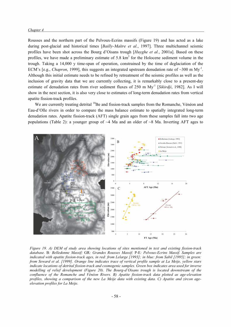
Chapter 4
- 58 -
Rousses and the northern part of the Pelvoux-Ecrins massifs (Figure 19) and has acted as a lake during post-glacial and historical times [Bailly-Maître et al., 1997]. Three multichannel seismic profiles have been shot across the Bourg d’Oisans trough [Huyghe et al., 2001a]. Based on these profiles, we have made a preliminary estimate of 5.8 km3 for the Holocene sediment volume in the trough. Taking a 14,000 y time-span of operation, constrained by the time of deglaciation of the ECM’s [e.g., Chapron, 1999], this suggests an integrated upstream denudation rate of ~300 m My-1. Although this initial estimate needs to be refined by retreatment of the seismic profiles as well as the inclusion of gravity data that we are currently collecting, it is remarkably close to a present-day estimate of denudation rates from river sediment fluxes of 250 m My-1 [Sikirdji, 1982]. As I will show in the next section, it is also very close to estimates of long-term denudation rates from vertical apatite fission-track profiles.
We are currently treating detrital 10Be and fission-track samples from the Romanche, Vénéon and Eau-d’Olle rivers in order to compare the mass balance estimate to spatially integrated long-term denudation rates. Apatite fission-track (AFT) single grain ages from these samples fall into two age populations (Table 2): a younger group of ~4 Ma and an older of ~8 Ma. Inverting AFT ages to
Figure 19. A) DEM of study area showing locations of sites mentioned in text and existing fission-track database. B: Belledonne Massif; GR: Grandes Rousses Massif; P-E: Pelvoux-Ecrins Massif. Samples are indicated with apatite fission-track ages, in red: from Lelarge [1993]; in blue: from Sabil [1995]; in green: from Seward et al. [1999]. Orange line indicates trace of vertical profile sample at La Meije, yellow stars indicate locations of detrital fission-track and cosmogenic samples. Green box indicates area used for inverse modelling of relief development (Figure 20). The Bourg-d’Oisans trough is located downstream of the confluence of the Romanche and Vénéon Rivers. B) Apatite fission-track data plotted as age-elevation profiles, showing a comparison of the new La Meije data with existing data. C) Apatite and zircon age-elevation profiles for La Meije.

Thermochronological data
- 59 -
denudation rates, using the approach of Brandon et al. [1998], leads to inferred denudation rates of 600-700 m My-1 and 350-400 m My-1 for these two age groups, respectively. Spatially averaged denudation rates from these data are 500±60 m My-1 over the last 3-5 My, apparently significantly higher than the short-term denudation rates inferred above. The samples yielded insufficient zircon to allow decomposition of ages into different groups; central zircon fission-track ages for samples BO10 and BO11 are 18.9±1.2 and 29.5±4.2 Ma, respectively. Using the same approach as for the apatite data, these ages suggest that denudation rates integrated over the Neogene are 260-420 m My-1, comparable to the inferred Holocene rates.
4.2.2. Constraints on relief development from thermochronological data In collaboration with Jean Braun, I am currently using a compilation of existing and newly acquired apatite fission-track data from the Pelvoux, Belledonne and Grandes Rousses ECM’s to constrain relief development over the last few My. Thermochronological databases are available for all three massifs [Lelarge Medeiros Vignol, 1993; Sabil, 1995; Seward et al., 1999] (Figure 19). Samples from the NE Belledonne massif show a clear age-elevation relationship, indicating a long-term denudation rate of ~350 m My-1 and an increase in denudation rates since ~3.5 Ma. Samples from the Grandes Rousses and Pelvoux massifs show much more scatter in the age-elevation relationship but also suggest a break in slope at 3-5 Ma (Figure 19b).
In order to better constrain the temporal evolution of denudation rates we sampled a new profile at La Meije, spanning an elevation range of 1300-3700 m. Initial results show clear age-elevation
Sample Stream N P1�(Ma)
W1
C1 %
P2�(Ma)
W2
C2 % RMS K-S
BO10 Romanche 47 3.4 0.35 59.0 8.3 0.28 41.0 0.017 0.663 BO11 Vénéon 44 4.8 0.19 28.5 8.3 0.27 71.5 0.023 0.648 BO12 Eau d'Olles 52 4.7 0.15 71.3 8.7 0.09 28.7 0.015 0.828
Sample V1 (m My-1)
V2 (m My-1)
V (m My-1)
min mean max min mean max min mean max
BO10 620 776 1050 320 397 524 448 558 744 BO11 524 600 702 322 397 517 362 439 559 BO12 478 609 848 334 359 389 425 508 633
Table 2. Detrital apatite fission-track data and inferred spatially integrated denudation rates for rivers draining the Pelvoux, Grandes Rousses and Belledonne massifs. Upper Table gives ages of populations after decomposing spectrum: N = number of grains counted; P1, P2 = peak ages of youngest and oldest populations; W1, W2 = relative 1�� peak width; C1, C2 = relative size of populations; RMS = root mean square misfit to the data; K-S = Kolmogorov-Smirnov fit. Inversion used peak-fitting code by Dunkl and Székely [2003] (http://homepages.uni-tuebingen.de/istvan.dunkl/softwares.html). Lower table shows inferred denudation rates V1 and V2 for these age groups, respectively. Denudation rates calculated following Brandon et al. [1998], taking into account both the compression of isotherms due to advection and the increase in closure temperature with cooling rate [Dodson, 1973]. Spatially averaged denudation rate V = 100 % / ((C1/V1) + (C2 / V2)).

Chapter 4
- 60 -
relationships for both zircon and apatite fission-track data, the trend being less steep for the high-temperature (zircon) than for the low-temperature (apatite) system (Figure 19c). Apatite fission-track ages cluster between 3.2-4.4 Ma at elevations below ~2000 m, suggesting a break-in-slope around this elevation. The data can be interpreted as indicating either a continuous increase in denudation rates since ~13 Ma or as reflecting the increasing control of relief on the temperature structure.
In order to test the different hypotheses for the denudation and relief history of the Pelvoux Massif, we predict the spatial pattern of apatite fission-track ages using Pecube [Braun, 2002b]. Three end-member models were tested: constant denudation rates and fixed relief, increasing denudation rates and fixed relief, constant denudation rates and increasing relief (Figure 20). The model results suggest that the coexisting AFT ages of <5 Ma in the valleys and ~10 Ma on the summits require significant relief increase (rapid valley carving) to have taken place since ~3.5 Ma.
An inverse method for assessing relief evolution from thermochronological data has recently been proposed [Braun, 2002a], based on the spectral analysis of age-elevation patterns. At short wavelengths, the closure isotherm (Tc) is not influenced by the topography and the age-elevation trend is equal to the true denudation rate (cf. Figure 7 in Section 1.3.1). At long wavelengths, in contrast, Tc completely mirrors the topography and there is no relationship between age and elevation; any relationship between age and elevation at long wavelengths necessarily indicates a recent change in relief.
In order to test the predictions of the forward model, we have used the data collected by Seward et al. [1999], roughly along an EW profile, to test for relief change using the inverse method (cf. box in Figure 19a). Since the data was not initially collected with this purpose in mind, it is far from ideal: the samples were collected along the major valleys rather than across them, the topography was not very well sampled because most samples were collected from valley bottoms, and sample spacing is very irregular. The power spectrum of topography and fission-track ages is therefore very noisy; nevertheless, the gain between AFT age and elevation at short wavelengths is consistent with a long-term denudation rate of ~300 m/My (Figure 21). Significantly, the gain at the longest wavelengths is positive, indicating that relief has increased since the samples passed Tc, 3-5 My ago. The inverse model, therefore, supports our inferences from the forward modeling exercise: both indicate a significant Late Pliocene – Quaternary increase in relief in the massif, which we would attribute to the effect of repeated glaciations. We are currently collecting a NS-oriented profile across all the major valleys in the Pelvoux Massif and sampling at regular 1-km intervals, in order to corroborate these preliminary conclusions.

Thermochronological data
- 61 -
Figure 20. Pecube forward modeling results for the three end-member models tested. Left panels show predicted apatite fission-track (AFT) ages draped over a DEM of the modelled area. View is from the NW, the Bourg-d’Oisans trough can be seen in the foreground. AFT ages were calculated only for areas of basement outcrop. Right panels show predicted AFT age-elevation relationships, to be compared with the data in Figure 19.

Chapter 4
- 62 -
4.3. Temporal evolution of denudation rates in the Nepal Himalaya: detrital
thermochronology of Siwalik deposits. The Himalaya is by far the most important source of sediment input to the world’s oceans [Hay, 1998; Summerfield and Hulton, 1994]; its denudational history should, therefore, have major consequences for global climate change if atmospheric CO2 drawdown from weathering and organic carbon burial plays a role in modulating climate [France-Lanord and Derry, 1997; Raymo and Ruddiman, 1992]. At the same time, the rates of denudation within the Himalayan system may have fluctuated considerably through time, controlled by tectonic and/or climatic factors, such as the onset of the Asian Monsoon. The erosional history of the Himalaya, as inferred from mass-balance studies, is controversial: whereas some studies have inferred a significant Quaternary increase in sediment fluxes [e.g., Métivier et al., 1999], others have suggested that fluxes have been decreasing since middle-late Miocene times [e.g., Burbank et al., 1993; Clift and Gaedicke, 2002].
Many different feedbacks between tectonic, erosional and climatic forcing have been proposed for the Himalaya, but relatively little data exists to constrain these. Beaumont et al. [2001] have
1000
2000
3000
4000
Elev
atio
n (m
)
890 900 910 920 930Easting (m)
0
5
10
15
20
FT A
ge (M
a)
10-1
100100
101
102
103
104
Pow
er (k
m2 /
My2 )
1125102050100Wavelength (km)
-20
-10
0
10
20
30
40
50
60
Gai
n (M
y km
-1)
1125102050100
Wavelength (km)
A
B
C
D
Figure 21. Results of spectral analysis along an E-W profile across the Pelvoux Massif, using the data collected by Seward et al. [1999]. A) Apatite fission-track ages along the profile (Easting in km refers to the Institut Géographique National Lambert III grid); B) Maximum, mean and minimum elevation along the profile, and location of samples; C) Power spectra of topography (solid line) and fission-track ages (dotted line); D) Spectral correlation between topographic and thermochronologic data; the gain at short wavelengths is compatible with a denudation rate of ~300 m My-1(dashed horizontal line); at longwavelengths, the gain remains constant.

Thermochronological data
- 63 -
suggested that the transition in tectonic styles, from mid-crustal extrusion along the MCT in early Miocene times to forward propagation of the Himalayan thrust wedge thereafter, may be controlled by diminishing erosional efficiency. On the basis of sedimentological, Nd-isotopic and U-Pb geochronological analyses of Siwalik foreland basin deposits, DeCelles et al. [1998], Huyghe et al. [2001b], and Robinson et al. [2001] have argued that Lesser Himalaya source rocks became widely exposed at ~8-10 Ma, possibly coinciding with propagation of the thrust wedge. A sharp increase in �
13C values in paleosol carbonates from Siwalik sediments at 7-8 Ma has been interpreted to indicate the onset of monsoonal climate conditions [Harrison et al., 1993; Quade et al., 1995], which, however, do not appear to have resulted in increased sedimentation rates [Burbank et al., 1993]. A direct link between uplift of the Tibetan Plateau and the onset of the Asian Monsoon, which has been suggested in the early 1990’s [e.g., Molnar et al., 1993], has become questionable with new isotopic data pushing the uplift of the Tibetan Plateau back to at least 11 Ma [Garzione et al., 2000; Rowley et al., 2001] and possibly 15 Ma [Spicer et al., 2003]. Finally, from a comparison of in-situ thermochronological and detrital cosmogenic data, Vance et al. [2003] have argued that denudation rates in the NW Himalaya have increased significantly during the last few My. Burbank [1992] has demonstrated rebound of the Ganges foreland basin since ~4 Ma, which he attributes to increased denudation of the mountain belt since that time.
In order to quantify the temporal evolution of denudation rates in the Nepal Himalaya, and to assess the role of the different controls on that evolution, we have sampled three well-dated sections of Siwalik foreland basin deposits along the Tinau and Surai rivers in central Nepal, and the Karnali River in western Nepal (cf. Figure 14 in Section 3.2 for locations) for detrital thermochronology. Depositional age control is provided by paleomagnetic data in these sections [Gautam and Rösler, 1999; Gautam and Fujiwara, 2000; T. Ohja, unpublished data]. Detrital thermochronology will be combined with Nd-isotopic analyses [e.g., Huyghe et al., 2001b] and single-grain U-Pb dating [Carter and Bristow, 2000] to infer variations in source areas, and with sedimentological [e.g., Nakayama and Ulak, 1999] and stable-isotope data to infer climatic variations. Samples were collected early this year and are currently being processed; preliminary results from a few pilot samples are shown in Figure 22.
Four pilot samples or groups of samples from the Tinau section yielded sufficient zircons for a component-age analysis [e.g., Garver et al., 1999]. Inversion of single grain ages to age populations was done using a binomial peak-fitting code recently developed by Dunkl and Székely [2003]. All four samples, with depositional ages between 10.9 and 6.6 Ma [following Gautam and Rösler, 1999], are dominated by a young zircon fission-track age peak around 15 Ma. A subordinate Mesozoic age peak (150-250 Ma) is also present in all samples, although it is nearly completely replaced by a 53 Ma age peak in the youngest sample (BUT5).
A tentative interpretation of these age patterns would have the 15 Ma age peak represent grains that are sourced from the rapidly eroding High Himalaya; the Mesozoic-age grains can only be derived from non-metamorphic cover rocks, i.e. the Tethyan Sedimentary Series or now eroded cover of the Higher Himalayan Crystalline nappes, and the intermediate age group may represent zircons from the Lesser Himalaya. This interpretation is consistent with Nd-isotopic data that show an increasing contribution of a Lesser Himalaya source upsection [Huyghe et al., 2001b; Robinson et al., 2001] and will be tested further by combining fission-track and U-Pb dating. It requires that the river that deposited the local Siwalik series drained the entire range, in contrast to the modern Tinau River, which has its headwaters within the Lesser Himalaya (cf. Figure 14).

Chapter 4
- 64 -
10
5 50010 50 100Fission-Track Age (Ma)
Prob
abilit
y (%
)
Rel. error [%]
Samples BUT4+TA5 (8.5 Ma)
0
10 15 20 30 50
15.2
188
+2�
-2�
N=56
5
5 50010 50 100Fission-Track Age (Ma)
Prob
abilit
y (%
)
Rel. error [%]
Sample BUT5 (6.6 Ma)
0
15 20 30 40 60
15.6
53
256N=32
+2�
-2�
7
5 50010 50 100Fission-Track Age (Ma)
Prob
abilit
y (%
)
Rel. error [%]
Samples BUT2+TA18A (10.6 Ma)
0
15 20 30 40 60
15.9
148
+2�
-2�
N=59
6
1 50010 100Fission-Track Age (Ma)
Prob
abilit
y (%
)
Rel. error [%]
Sample TA17 (10.9 Ma)
0
10 15 20 30 40 60
14.9
165N=51
+2�
-2�
Age components:P1=14.9 Ma
(W=0.44; C=76%)P2=165 Ma
(W=0.70; C=24%)
Age components:P1=15.9 Ma
(W=0.44; C=77%)P2=148 Ma
(W=0.07; C=24%)
Age components:P1=15.2 Ma
(W=0.25; C=75%)P2=188 Ma
(W=0.27; C=25%)
Age components:P1=15.6 Ma
(W=0.28; C=74%)P2=53 Ma
(W=0.71; C=24%)P3=256 Ma
(W=0.49; C=2%)

Thermochronological data
- 65 -
Interestingly, the nearly constant young age peak implies that lag times increase considerably
upsection, from 4.0 Ma for sample TA17 (depositional age 10.9 Ma) to 9.0 Ma for sample BUT5 (6.6 Ma), and denudation rates therefore decrease since the Middle Miocene. Using the paleomagnetic data of Ohja [unpublished], instead of those from Gautam and Rösler [1999], to constrain depositional ages exacerbates these differences: the lag time for TA17 decreases to 3.4 Ma and that for BUT5 increases to 9.1 Ma. Denudation rates calculated from these lag times, using the same approach as in the previous section, decrease from ~1.2 km My-1 for TA17 to ~680 m My-1 for BUT5.
The above preliminary results are at odds with models of continuous steady-state denudation of the Himalaya from Middle Miocene times to the present [Copeland and Harrison, 1990; Galy et al., 1996; Harrison et al., 1993] and contrast to earlier analyses of detrital zircons in the Siwaliks of Pakistan [Cerveny et al., 1988], downstream of the rapidly uplifting and incising Nanga Parbat massif [Burbank et al., 1996; Zeitler et al., 2001], which show decreasing lagtimes upsection (M. Bernet, Pers. Commun., 2003). They are, however, consistent with recent detrital 40Ar-39Ar data from Siwalik and older deposits [Najman et al., 2003; Szulc et al., 2003; White et al., 2002] that also show increasing lag times and decreasing denudation rates from ~17 to ~12 Ma. The inferred late Miocene rates of denudation are significantly lower than present-day river incision [Lavé and Avouac, 2001] and denudation [Blythe et al., 2002a; Brewer et al., 2003; France-Lanord and Bourlès, 2001] rates of 1-4 km My-1 in the High Himalaya of central Nepal. These preliminary data therefore suggest significant temporal variation in denudation rates.
We have also started detrital apatite fission-track analyses on these samples. Because of the lower U-content of apatite, with respect to zircon, single grain ages on apatite are prone to larger uncertainties and the discrimination of component populations is more difficult [Garver et al., 1999]. However, apatite data provide complementary information to zircon data; in particular, we hope to be able to better constrain the recent history of denudation rates (and possibly relief development) in response to the onset of Quaternary glaciations. Since apatite anneals at significantly lower temperatures than zircon (Table 1, Section 1.3.1), the source signal may be lost for samples that have been at depths of a few km; in exchange however, the post-depositional history of the basin can be constrained by detrital apatite data [e.g., Rohrman et al., 1996]. In the Siwalik case, we hope to gain information on the timing of activity of the major thrusts in the fold-and-thrust belt. Data from four pilot samples from the Karnali and Tinau sections are presented in Figure 23. Detrital apatite fission track ages evolve from practically all older than the depositional age in the youngest, least deeply buried samples (KA30) to all younger than the depositional age in the oldest, deepest sample (KA441), reflecting increasing annealing. Samples KA30 and KA34 are described as well by a single age population as a two-component population; their central ages are both 3.0 My older than the depositional age, corresponding to spatially integrated denudation rates of ~850 m My-1, relatively close to that found for the youngest zircon samples. Sample KA34 is, however, obviously affected by
Figure 22 (opposite page): Results of detrital zircon fission-track analyses for six pilot samples from the Tinau section (depositional ages indicated in parentheses). Samples from the same stratigraphic level have been regrouped – individual samples show indistinguishable results. Samples labelled BUT were collected by Jérôme Lavé; those labelled TA by Adam Szulc (University of Edinburgh). Left panels show radial plots with component ages indicated; right panels show histograms of single-grain age distributions and composite probability density plot (note logarithmic age scale for these plots). Fitted age peaks, together with relative peak widths and heights, are indicated.

Chapter 4
- 66 -
partial annealing, as indicated by single-grain ages younger than the depositional age. Sample KA441 is characterized by a clear young age peak of 2.5 Ma, interpreted as representing a totally annealed population, as well as a less clearly defined peak around 9 Ma that represents partially annealed apatite grains. The age of 2.5 Ma is therefore geologically significant and indicates the onset of exhumation along the Main Frontal Thrust for this sample. 4.4. Conclusions New techniques for collecting and interpreting thermochronological data are providing new insights into the spatial and temporal evolution of denudation rates and relief development. A reinterpretation of existing data and the targeted collection of new data from one of the External Crystalline Massifs of the western Alps (Section 4.2) suggest that, in concert with denudation rates, relief has increased considerably since late Pliocene times in this region. Whether tectonic or climatic changes caused the increase in cooling rates and relief is not clear at this stage, but the widespread nature of increased denudation rates in the Alps, as well as the coincidence in timing with the onset of glaciations suggest that climate may play a central role. A comparison of denudation rates measured on different time scales suggests that glacial denudation rates (recorded by detrital apatite fission-track data) may be significantly higher than both pre-Quaternary and Holocene rates. Detrital cosmogenic data will help to test this preliminary conclusion.
Preliminary detrital fission-track data from the Siwaliks in central and western Nepal (Section 4.3) suggest that spatially averaged denudation rates have varied strongly since middle Miocene
Rel. error [%]
-2
-1
0
1
2
15 20 30 40 60
4.3
7.3
13Sample KA30 (4.3 Ma)
7.3±0.5 MaN=41D=28%
Rel. error [%]
-2
-1
0
1
2
20 30 40 50 70
6.4
9.3
18Sample KA34 (6.4 Ma)
9.3±0.5 MaN=63D=24%
Sample BUT3 (9.9 Ma)
6.0±0.6 MaN=29D=42%
Rel. error [%]
-2
0
2
20 30 40 50 70
6.0
9.9
3.0
.
.
.
Sample KA441 (15.9 Ma)
3.9±0.5 MaN=44D=76%
Rel. error [%]
-2 0 2
15 20 30 40 60
3.9
9.0
15.9
2.5
Figure 23. Results of detrital apatite fission-track analyses for three pilot samples from the Karnali section (samples KA; collected by P. Huygheand J.L. Mugnier) and one from the Tinau section (BUT3; collected by J. Lavé). Radial plots show deviation from a mean value as a function of precision for each single-grain age. Lines indicate depositional age (in italic), central age (in bold) and maximum (for samples KA30 and KA34) or minimum (sample BUT3) age containing 95% of the data. Sample KA441 was the only one for which two component populations fitted the data significantly better than a single population: they show a well-defined young peak (P1 = 2.5 Ma; W = 0.2; C= 75%) and a “blurred” second peak (P2=9.0 Ma; W=0.9; C=25%). Both age peaks are shown, together with the depositonal age (in italic) and the central age (in bold). N = number of grains counted; D = age dispersion.

Thermochronological data
- 67 -
times, in contrast to models of continuous steady-state exhumation of the Himalaya. They also suggest that source regions may have varied through time, in accord with geochemical data. As more data become available, these temporal variations in denudation rates and source areas will be mapped out in more detail, and the climatic and/or tectonic controls on them elucidated. Apatite fission-track data from the same samples permits to constrain shorter term denudation rates as well as the post-depositonal thermal and kinematic history of the thrust belt.

Chapter 5
- 68 -
5. OUTLOOK AND RESEARCH PERSPECTIVES The results presented in the preceding three chapters suggest that, although significant and innovative results have been obtained using numerical Surface Process Models, continued testing and development of such models, together with the collection of veritably constraining data, are still urgently needed. I will continue to use Surface Process Models to study relief and drainage development in specific areas; I am, for instance, currently involved in studying the possible controls on the geomorphic asymmetry of the Ladakh Batholith as observed by Jamieson et al. [2003]. However, I feel that the priority should now be the further development of these models, with the aim of including rigorously tested surface process algorithms. Two erosional agents require particular attention: fluvial incision and transport, and glacial erosion. I will develop some ideas on how to advance in these studies below. Finally, new developments in thermochronological data collection and interpretation appear very promising; these also require testing and more widespread application. 5.1. Toward a general model for fluvial incision The conceptual model for fluvial incision and transport developed in Section 2.3 suggests that sediment flux exerts an important control on bedrock river gradients and is in qualitative agreement with modelling results for a river in an entirely different tectonic setting developed in Section 2.2. However, at least three different fluvial incision algorithms may account for the observed behaviour: a combination of simple detachment-limited and transport-limited stream power models [e.g., Whipple and Tucker, 2002], “Undercapacity” models [Beaumont et al., 1992] or “Tools” models [Sklar and Dietrich, 1998; Slingerland et al., 1997]. The latter class of models appears the most physically realistic and inclusive; however, the few model tests that have been performed up to now do not favour Tools models over other classes of incision models [Slingerland et al., 1998; Tomkin et al., 2003; van der Beek and Bishop, 2003].
How to advance in these questions? The ideal strategy would be to monitor sediment flux within a well-studied catchment in order to establish the links between discharge, drainage area and sediment flux. These data would directly constrain Undercapacity and Tools models, which predict specific relationships between discharge and sediment flux. A possible “natural laboratory” for such a study could be the Cévennes-Vivarais area in SE France, where a dense hydro-meteorological observation network has already been installed by the hydrology department of the Observatoire des Sciences de l’Univers de Grenoble (the Observatoire Hydro-Météorologique Méditerranéen – Cévennes Vivarais; cf. http://www.lthe.hmg.inpg.fr/OHM-CV/index.htm). Such a strategy is, however, relatively ambitious. The relevant flux to measure is that of the bedload, for which representative measurements, especially at high discharge stages, are particularly difficult. Given the requirement of continuous measurements at different sites along the river, acoustic techniques would appear most promising but require extensive calibration.
A shorter-term strategy involves the continued study of river long-profile development. The study of Alpine rivers in Section 2.3 has shown that, in steady-state conditions, these rivers are detachment-limited upstream (as indicated by profile gradients that vary with lithology) and transport-limited

Outlook and Perspectives
- 69 -
downstream (as indicated by smooth river profiles and variable valley-flat widths). The three river incision models make specific predictions about the shape of the transition [Whipple and Tucker, 2002]; however, the resolution of stream profile measurements from topographic maps is insufficient to discriminate between the models [Brocard and van der Beek, submitted]. A more detailed database of these headwater reaches (up to contributing drainage areas of ~50 km2) is therefore required, and can be obtained by surveying the channels using kinematic GPS. At the same time, the major lithological units should be sampled for experimental abrasion [Attal and Lavé, 2003] and/or tensile strength [Sklar and Dietrich, 2001] measurements, in order to isolate variations in rock erodability from other possible factors influencing incision rates. The data collected this far are, however, sufficient to constrain and test forward models of fluvial incision, following the methodology of Tomkin et al. [2003] and van der Beek and Bishop [2003]. The data also suggest, however, that additional parameters may be required in these models, notably the calibre of bedload and its downstream evolution. A key characteristic of the western Alpine rivers is that both equilibrium and disequilibrium streams occur (cf. Section 2.3). These different streams are characterised by order-of-magnitude variations in incision rates, setting further constraints on river incision models. Notably, a comparison of best-fit model parameters for equilibrium and non-equilibrium rivers, together with available discharge data, may show whether stochastic and threshold effects, as anticipated by Tucker and Bras [2000] and Snyder et al. [2003], play a role.
Other markers of fluvial incision in the western Alps, which have received relatively little attention, occur in the form of postglacial gorges that connect hanging valleys to the trunk streams. These are particularly widespread and spectacularly developed in and around the Pelvoux-Ecrins Massif [e.g., Montjuvent, 1974, 1978]. Since the time span of operation should be similar for all gorges, mapping the amount of incision as a function of slope, drainage area and bedrock lithology should provide constraints on river incision models. Most of these gorges occur at relatively small drainage areas, where tributary valleys join the trunk stream, and where the three models predict very different dependencies of incision capacity on discharge (and thus drainage area). The main problem to be overcome here is that some of the gorges, especially the larger ones, may have operated as subglacial channels before deglaciation [Montjuvent, 1974]. A comparison of short-term incision rates, determined from in-situ cosmogenic isotope measurements, with expected incision rates if the gorges operated during post-glacial times only, may help to resolve this uncertainty.
Finally, a new area for the study of the interaction between active deformation and drainage development has opened up in the Zagros Mountains of southern Iran. Together will Jérôme Lavé and an Iranian PhD student, Benham Oveisi, we will quantify incision rates along two major rivers traversing the Zagros fold-and-thrust belt (the Dalakil and Mand rivers) by mapping and cosmogenic dating of fluvial terraces, using the techniques developed with Gilles Brocard [e.g., Brocard et al., 2003]. The data will be combined with structural data, as well as recently acquired seismotectonic and geodetic data [e.g., Tatar et al., 2002] to propose a kinematic model for the deformation of the fold-and-thrust belt. Once incision rates are quantified along these major transverse rivers, the control of lithology and uplift/incision rates on long profile development can be studied. The Zagros are an ideal setting for such a study because they are characterised by strong lithological variations within a sedimentary pile comparable to that of the external Alps, but we also expect strongly varying rock uplift rates along the streams as they cross active anticlines and synclines that are deforming at different rates. Valley-width variations that are controlled by lithology are well known from the Zagros, as the rivers form spectacular gorges where they cross the most resistant Oligocene limestone

Chapter 5
- 70 -
units [Oberlander, 1965]. The Zagros also provide some of the best examples in the world of the control of actively growing folds on planform drainage development [Oberlander, 1965, 1985]. The models that we have developed for drainage development in the Siwaliks of Nepal (cf. Section 3.2) can therefore also be tested in this region. 5.2. Glacial erosion, denudation rates, and relief development The proposal that Quaternary climate change has driven uplift of mountain summits [Molnar and England, 1990] hinges on the question of whether glacial erosion significantly enhances the relief of mountain belts (cf. Section 1.1). Whereas the data that support widespread Late Pliocene – Quaternary increase in the rates of denudation of mountain belts appears convincing [e.g., Kuhlemann et al., 2002; Métivier et al., 1999; Zhang et al., 2001] and at least part of this increase may be linked to increasing glacial cover [Hallet et al., 1996], the question of whether relief may be increased by glaciations is not settled.
On the one hand, modal elevations in tectonically active glaciated mountain belts, such as the NW Himalaya or the Southern Alaska Range, appear to be controlled by the Equilibrium Line Altitude (ELA) of glaciers rather than by tectonic uplift rates [Brozovic et al., 1997; Meigs and Sauber, 2000], and slope distributions show a characteristic minimum around the ELA. These observations have been interpreted as indicating that glacial removal of material above the ELA is very efficient and that glaciations therefore lead to diminished, rather than increased, relief (the “glacial buzz-saw” hypothesis of Brozovic et al. [1997]). The relatively similar relief structure of glaciated mountain ranges in temperate regions, in spite of order-of-magnitude differences in tectonic rock uplift rates (i.e. European Alps, Sierra Nevada, Rocky Mountains, Southern Alps of New Zealand, Southern Alaska Range), as well as the significant along-strike changes in relief structure of the Andes as they pass into latitudes that are prone to glaciation [Montgomery et al., 2001], also argue for a strong negative feedback between glaciation and relief production.
In contrast to these findings, comparisons of fluvial and glacial relief in mountain ranges generally find that relief has increased due to glacial action, notably due to the carving of large glacial valleys [Brocklehurst and Whipple, 2002; Kirkbride and Matthews, 1997; Montgomery, 2002; Schlunegger and Hinderer, 2003; Small and Anderson, 1995, 1998]. Our own preliminary data from the western Alps (section 4.2) also suggest that denudation rates and relief have increased since 3.5 Ma. The stratigraphic record of foreland basins has been interpreted as suggesting significant recent isostatic rebound of mountain ranges due to increased Quaternary denudation [Burbank, 1992; Cederbom et al., submitted]. Where attempts have been made to calculate the isostatic response to erosional unloading and relief production [Brocklehurst and Whipple, 2002; Small and Anderson, 1998], however, these have found that isostatic uplift of mountain peaks was not sufficient to significantly offset their erosional lowering. Nevertheless, moderately active mountain belts such as the European Alps appear the most promising settings to test the proposition by Molnar and England [1990]; since denudation rates are an order of magnitude slower in these settings than in highly active mountain belts, the topography has been influenced by numerous glacial cycles and it is in these settings that the most convincing evidence for relief increase has been gathered (cf. references above). I therefore propose to study glacial relief development in the western Alps both through

Outlook and Perspectives
- 71 -
DEM and morphological analyses and by incorporating glacial erosion in numerical surface process models. 5.2.1. Glacial controls on relief development in the western Alps A significant observational database exists concerning the glacial morphology of the western Alpine massifs [e.g., Beaudevin, 2000; Montjuvent, 1974, 1978]. Although most of the data are rather qualitative, they can be used to reconstruct the ELA and trimline during full glacial conditions. A comparison of these data with the relief structure of the massifs, from DEM analyses, should allow to quantify the glacial control on relief. A previous DEM study of the Pelvoux-Ecrins, Belledonne and Grandes Rousses massifs [Peysson, 2000] has shown significant differences in relief structure between these massifs but did not explore possible controls on these. Such an analysis, together with a detailed analysis of glacial and fluvial valley profiles, should lead to a reconstruction of pre-glacial topography, which can then be used to assess relief changes and the isostatic response to glacial erosion. At the same time, comparisons of cosmogenic isotope inventories from mountain summits and valley bottoms can be used to directly assess relief variations over the last few tens to hundreds of thousands of years [e.g., Small et al., 1997]. 5.2.2. Incorporating glacial erosion in numerical surface process models Geomorphic and thermochronological data appear very promising in reconstructing Quaternary denudation rates and relief development, but numerical models will be required in order to fully explore the possible controls of increased glaciation on mountain belt topography. Only few models for glacial erosion have been proposed. Two-dimensional models of glacial valley development have been presented by Oerlemans [1984], Harbor [1992] and MacGregor et al. [2000] and theoretical descriptions of the most relevant processes have been developed by Hallet [1979, 1996]. A full planform surface process model including glacial erosion, however, has only been published by Braun et al. [1999]. Tomkin and Braun [2002], who explored the predictions of this model for relief development in active glaciated mountain ranges, concluded that relief is likely to decrease due to glacial action.
Of the two physical processes of ice-bedrock interaction, abrasion and quarrying (glacial plucking), the latter appears the most efficient, as indicated by cosmogenic isotope inventories of glacial forms eroded by these two mechanisms [e.g., Colgan et al., 2002; Gosse et al., 2000]. Perhaps surprisingly, the data collected this far on glacial erosion suggests that erosion rates may simply scale linearly with basal sliding velocity [Hallet, 1996; Hallet et al., 1996]. Sliding velocity is generally considered a function of basal shear stress and effective normal pressure [Braun et al., 1999; MacGregor et al., 2000; Paterson, 1994], which in turn are controlled by ice thickness. The models therefore need to include an ice-balance model that predicts ice thickness (h):
Mhth
����
� u (17)
where u is the vertically integrated horizontal ice velocity and M is the mass balance term. Local ice velocity is the sum of two terms: basal sliding and internal deformation; the latter term can be modelled using an ice flow law. A geometric shape factor is usually included to account for slowing

Chapter 5
- 72 -
down of ice flow at constrictions. The ice mass balance is the sum of accumulation through precipitation and surficial and basal melting. The latter terms can be modelled simply as a function of mean yearly temperature [Braun et al., 1999] or as a function of positive degree days [MacGregor et al., 2000; Merrand and Hallet, 2001].
A robust outcome of the models is that ice thickness, sliding velocity, and therefore erosion rates are largest at the ELA. The mass-balance term, as well as the ice dynamics model, therefore crucially control model predictions. Practically no model calibration has been performed until present, however, and it is therefore not clear whether strong model predictions such as those by Tomkin and Braun [2002] are robust or, instead, model artefacts. A critique of all the models as they have been applied up to now may be that ice melting and ablation is neither a direct function of temperature nor positive degree days, but of the short- and long-wave radiative, latent, and sensible energy fluxes into and out of the ice surface [Lliboutry, 1964; Oerlemans, 1992]. However, mean yearly temperature, which controls incoming long-wave radiation and sensible heat, appears to be the single most important factor in controlling the mass balance of alpine glaciers [Vincent, 2002]. Also, none of the models predict glacial overdeepenings, which are first-order features of glacial landscapes and may drive important feedbacks between ice dynamics and bedrock erosion [Hooke, 1991].
As for the fluvial incision models, testing and calibration of glacial erosion models is therefore urgently required. The western Alpine massifs appear as an ideal region for such an exercise, because long-term monitoring of present-day glacial mass balances exists [e.g., Vincent, 2002 and references therein] and ice thicknesses during full glacial conditions can be reconstructed [e.g., Beaudevin, 2000; Montjuvent, 1978]. Therefore, an ice-mass balance model can be calibrated against both present-day and full glacial conditions. In the ideal case, the erosion model should be calibrated using present-day field observations [e.g., Humphrey and Raymond, 1994]. As for fluvial erosion, such a database could be developed, in the long term, by adding sediment traps to the Alpine glacier monitoring sites that are followed in the framework of the Observatoire des Glaciers Alpins, and for which long-term mass-balance and velocity measurements exist already (cf. http://glaciog.ujf-grenoble.fr/equipes/glaciers/DonneesDisp/ServiceObs/home.html). However, present-day sediment flux from glaciers maybe unusually high because they have been retreating continuously for the last few 100 y, since the Little Ice Age, and may therefore not be representative of long-term erosion rates [Koppes and Hallet, 2002]. An alternative approach would be to tune model parameters to the amount of glacial erosion integrated over numerous glacial cycles, as reconstructed from the DEM analysis (cf. previous section). The data gathered in the western Alps can then be compared to similar data from tectonically active glaciated mountain ranges like the western Alps of New Zealand (research project by Jean Braun underway), or possibly the southern Andes, in order to explore and constrain how rock uplift rates influence the glacial controls on topography. 5.3. New thermochronological databases and interpretative tools In concert with the model testing and calibration described above, continued efforts should go into the development of new thermochronological databases and their interpretation. I will continue the work in the western Alpine massifs that aims at constraining recent relief development (Section 4.2). Sensitivity analyses of the forward-model approach to assessing relief development will be carried

Outlook and Perspectives
- 73 -
out using a neighbourhood algorithm similar to that used in Section 4.1. Collection of data along a NS profile across the Pelvoux-Ecrins massif should be terminated this year; both fission-track and (U-Th)/He analyses will be performed on apatite from these samples in order to constrain relief development. A second profile will be collected accross the Dora Maira massif of the internal Alps, in collaboration with Pierre Tricart, in order to constrain possible tectonic controls on relief development. The internal Alps form the hangingwall of the Penninic Front that has been reactivated as an extensional detachment since Miocene times [Sue and Tricart, 2003; Tricart et al., 2001]; relief and denudation rates are more subdued in the internal Alpine massifs than in the external massifs. The comparison between internal and external massifs will therefore provide a strong test of tectonic versus climatic controls on relief development: if relief has increased similarly in the internal and the external massifs, then a climatic cause appears very probable.
At the same time, the western Alpine arc and its foreland basin deposits also appear an ideal area to test the possibility of deconvoluting the relief of the source area from detrital thermochronological data. Models that have been developed so far [e.g., Brewer et al., 2003; Stock and Montgomery, 1996] suppose topographic steady-state with denudation rates that are constant throughout the landscape, which does not appear relevant for the Late Pliocene – Quaternary history of the western Alps. Together with Matthias Bernet, we will collect a suite of samples from well-dated post-10 Ma deposits on both sides of the arc for detrital apatite and zircon fission-track thermochronology; we will test whether relief development can be demonstrated from these data, constrained by the in-situ data collected in both the internal and external crystalline massifs.
We will also continue the Himalayan detrital work introduced in Section 4.3. A novel approach here will be to test whether temporal variations in denudation rates can be linked to changes in source areas, by combining single-grain zircon fission-track thermochronology and U-Pb geochronology. The Himalaya appears an ideal region to test this approach as the different tectonic units are characterized by strongly differing U-Pb age signals [DeCelles et al., 1998, 2000], and because geochemical constraints on source areas exist already [Huyghe et al., 2001b; Robinson et al., 2001]. We will also compare detrital zircon fission-track and (U-Th)/He thermochronology on these samples, in collaboration with Raphaël Pik (CRPG Nancy). The multimethod approach should lead to clear indications concerning the temporal evolution of denudation rates and source areas for the Siwalik sediments. If the Alpine test of the method of deconvolving low-temperature detrital thermochronometry data for relief development is positive, it will also be applied to the youngest (Upper) Siwalik series in order to test for possible relief changes in the Himalayan source areas over the last few My.
The counterintuitive inferences that we draw from Bénédicte Champel’s numerical model experiments (lower denudation rates in the Eastern Himalaya despite a more intense monsoon?) warrant extending our study to eastern Nepal, Sikkim and Bhutan. No dated sections exist, however, east of Nepal; therefore, any study of the Siwaliks in Sikkim or Bhutan should include new magnetostratigraphic data collection. As very few in-situ bedrock thermochronological data is available from Sikkim and Bhutan (the only data I am aware of being that of Duncan et al. [2002]), a campaign in this area should include sampling bedrock along a cross-section across the Himalaya. I am currently processing a limited number of pilot samples from Sikkim, collected by Georges Mascle.
Further development of fission-track thermochronology requires, however, settling of the contentious issue of possible pressure dependence of fission-track annealing raised by Wendt et al.

Chapter 5
- 74 -
[2002]. Although the methodology of that study has been criticised [Donelick et al., 2003; Kohn et al., 2003], its possible implications warrant that new experiments be done on both apatite and zircon. Together with Olivier Vidal, now at the LGCA, we aim at running a new series of experiments, focusing on zircon annealing for which possible pressure effects should, in theory, be larger than for apatite (O. Vidal, Pers. Commun. 2003). Such a study would be accompanied by multi-method field data from a (ultra) high-pressure terrain such as Dora Maira, in order to study whether possible pressure effects on annealing are detectable in natural samples.

References
- 75 -
REFERENCES Adams, J., Contemporary uplift and erosion of the Southern Alps, New Zealand: Summary, Geol. Soc. Am.
Bull., 91, 1-114, 1980. Ahnert, F., Functional relationships between denudation, relief and uplift in large mid-latitude drainage basins,
Am. J. Sci., 268, 243-263, 1970. Anderson, R.S., Evolution of the Santa Cruz Mountains, California, through tectonic growth and geomorphic
decay, J. Geophys. Res., 99, 20161-20180, 1994. Anderson, R.S., J.L. Repka, and G.S. Dick, Explicit treatment of inheritance in dating depositional surfaces
using in situ 10Be and 26Al, Geology, 24, 47-51, 1996. Arrowsmith, J.R., D.D. Pollard, and D.D. Rhodes, Hillslope development in areas of active tectonics, J.
Geophys. Res., 101, 6255-6275, 1996. Attal, M., and J. Lavé, Pebble and bedrock abrasion during fluvial transport in active orogenic settings:
experimental study and application to natural hydrographic networks, Geophys. Res. Abstr., 5, 00664, 2003.
Avouac, J.P., and E.B. Burov, Erosion as a driving mechanism of intracontinental mountain growth, J. Geophys. Res., 101, 17747-17769, 1996.
Avouac, J.P., P. Tapponnier, M. Bai, H. You, and G. Wang, Active thrusting and folding along the northern Tien Shan and Late Cenozoic rotation of the Tarim relative to Dzungaria and Kazakhstan, J. Geophys. Res., 98, 6755-6804, 1993.
Bailly-Maître, M.-C., G. Montjuvent, and V. Mathoulin, Les quatre anciens lacs de l'Oisans (Alpes françaises du Nord), Rev. Géogr. Alp., 85, 33-52, 1997.
Baldwin, J.A., K.X. Whipple, and G.E. Tucker, Implications of the shear stress river incision model for the timescale of postorogenic decay of topography, J. Geophys. Res., 108, 2158, doi: 10.1029/2001JB000550, 2003.
Balestrieri, M.L., M. Bernet, M.T. Brandon, V. Picotti, P. Reiners, and M. Zattin, Pliocene and Pleistocene exhumation and uplift of two key areas of the Northern Apennines, Quat. Int., 101-102, 67-73, 2003.
Basile, C., and P. Allemand, Erosion and flexural uplift along transform faults, Geophys. J. Int., 151, 646-653, 2002.
Batt, G.E., The approach to steady-state thermochronological distribution following orogenic development in the Southern Alps of New Zealand, Am. J. Sci., 301, 374-384, 2001.
Batt, G.E., M.T. Brandon, K.A. Farley, and M. Roden-Tice, Tectonic synthesis of the Olympic Mountains segment of the Cascadia wedge, using two-dimensional thermal and kinematic modeling of thermochronological ages, J. Geophys. Res., 106, 26731-26746, 2001.
Batt, G.E., and J. Braun, On the thermo-mechanical evolution of compressional orogens, Geophys. J. Int., 128, 364-382, 1997.
Batt, G.E., and J. Braun, The tectonic evolution of the Southern Alps, New Zealand: insights from fully thermally coupled dynamical modelling, Geophys. J. Int., 136, 403-420, 1999.
Batt, G.E., J. Braun, B.P. Kohn, and I. McDougall, Thermochronological analysis of the dynamics of the Southern Alps, New Zealand, Geol. Soc. Am. Bull., 112, 250-266, 2000.
Beaudevin, C., Contribution à l'étude de l'altitude atteinte par les glaciers quaternaires dans quelques vallées alpines, Géol. Alp., 76, 83-116, 2000.
Beaumont, C., P. Fullsack, and J. Hamilton, Erosional control of active compressional orogens, in Thrust Tectonics, edited by K.R. McClay, pp. 1-18, Chapman & Hall, London, 1992.
Beaumont, C., R.A. Jamieson, M.H. Nguyen, and B. Lee, Himalayan tectonics explained by extrusion of a low-viscosity channel coupled to focused surface denudation, Nature, 414, 738-742, 2001.
Beaumont, C., H. Kooi, and S. Willett, Progress in coupled tectonic - surface process models with applications to rifted margins and collisional orogens, in Geomorphology and Global Tectonics, edited by M.A. Summerfield, pp. 29-56, Wiley, Chichester, 2000.

References
- 76 -
Benedetti, L., R. Finkel, D. Papanastassiou, G. King, R. Armijo, R.J. Ryerson, D. Barber, and F. Flerit, Post-glacial slip history of the Sparta fault (Greece) determined by 36Cl cosmogenic dating: evidence for non-periodic earthquakes, Geophys. Res. Lett., 29, doi: 10.1029/2001GL014510, 2002.
Bernet, M., M. Zattin, J.I. Garver, M.T. Brandon, and J.A. Vance, Steady-state exhumation of the European Alps, Geology, 29, 35-38, 2001.
Bichet, V., M. Campy, J.-F. Buoncristiani, C. Digiovanni, M. Meybeck, and H. Richard, Variations in sediment yield from the Upper Doubs river carbonate watershed (Jura, France) since the Late-Glacial period, Quat. Res., 51, 267-279, 1999.
Bierman, P.R., Using in situ produced cosmogenic isotopes to estimate rates of landscape evolution: A review from the geomorphic perspective, J. Geophys. Res., 99, 13885-13896, 1994.
Bierman, P.R., and M. Caffee, Slow rates of rock surface erosion and sediment production across the Namib desert and escarpment, southern Africa, Am. J. Sci., 301, 326-358, 2001.
Bierman, P.R., and M. Caffee, Cosmogenic exposure and erosion history of Australian bedrock landforms, Geol. Soc. Am. Bull., 114, 787-803, 2002.
Bigot-Cormier, F., G. Poupeau, and M. Sosson, Dénudations différentielles du massif cristallin externe alpin de l'Argentera (Sud-Est de la France) révélées par thermochronologie traces de fission (apatites, zircons), C.R. Ac. Sci. Paris, 330, 363-370, 2000.
Bilham, R., and P. England, Plateau 'pop-up' in the great 1897 Assam earthquake, Nature, 410, 806-809, 2001. Bishop, P., and G. Goldrick, Geomorphological evolution of the East Australian continental margin, in
Geomorphology and Global Tectonics, edited by M.A. Summerfield, pp. 225-254, Wiley, Chichester, 2000.
Bishop, P., R.W. Young, and I. McDougall, Stream profile change and longterm landscape evolution: Early Miocene and modern rivers of the east Australian highland crest, central New South Wales, Australia, J. Geol., 93, 455-474, 1985.
Blythe, A., J. Putkonen, K.L. Schmidt, and D.W. Burbank, Post 2 Ma cooling and denudation patterns along the Marsyandi drainage in the Central Nepalese Himalaya from apatite fission track and (U-Th)/He analyses, Eos Trans. AGU, 83 (Fall Meeting Suppl.), T72B-12, 2002a.
Blythe, A.E., D.W. Burbank, K.A. Farley, and E.J. Fielding, Structural and topographic evolution of the central Transverse Ranges, California, from apatite fission-track, (U-Th)/He and digital elevation model analyses, Basin Res., 12, 97-114, 2000.
Blythe, A.E., M.A. House, and J.A. Spotila, Low-temperature thermochronology of the San Gabriel and San Bernardino Mountains, southern California: Constraining structural evolution, in Contributions to Crustal Evolution of the Southwestern United States, edited by A. Barth, pp. 231-250, Geological Society of America, Boulder, CO, 2002b.
Bohannon, R.G., C.W. Naeser, D.L. Schmidt, and R.A. Zimmerman, The timing of uplift, volcanism and rifting peripheral to the Red Sea: A case for passive rifting?, J. Geophys. Res., 94, 1683-1701, 1989.
Boudiaf, A., J.-F. Ritz, and H. Philip, Drainage diversions as evidence of propagating active faults: example of the El Asnam and Thenia faults, Algeria, Terra Nova, 10, 236-244, 1998.
Brandon, M.T., M. Roden-Tice, and J.I. Garver, Late Cenozoic exhumation of the Cascadia accretionary wedge in the Olympic Mountains, northwest Washington State, Geol. Soc. Am. Bull., 110, 985-1009, 1998.
Braun, J., Estimating exhumation rate and relief evolution by spectral analysis of age-elevation profiles, Terra Nova, 14, 210-214, 2002a.
Braun, J., Quantifying the effect of recent relief changes on age-elevation relationships, Earth Planet. Sci. Lett., 200, 331-343, 2002b.
Braun, J., and M. Sambridge, Modelling landscape evolution on geological time scales: a new method based on irregular spatial discretization, Basin Res., 9, 27-52, 1997.
Braun, J., D. Zwartz, and J.H. Tomkin, A new surface processes model combining glacial and fluvial erosion, Ann. Glaciog., 28, 282-290, 1999.
Brewer, I.D., D.W. Burbank, and K.V. Hodges, Modelling detrital cooling-age populations: insights from two Himalayan catchments, Basin Res., 15, 305-320, 2003.

References
- 77 -
Brocard, G.Y., and P.A. van der Beek, Influence of incision rate, rock strength and bedload supply on bedrock river gradients and valley-flat widths: Field-based evidence and calibrations from western Alpine rivers (SE France), in Tectonics, Climate and Landscape Evolution, edited by S.D. Willett, N. Hovius, M.T. Brandon, and D. Fisher, Geol. Soc. Am. Spec. Publ., submitted.
Brocard, G.Y., P.A. van der Beek, D.L. Bourlès, L.L. Siame, and J.-L. Mugnier, 10Be dating of some major extents of the last glaciations in the French Alps, Quat. Sci. Rev., submitted.
Brocard, G.Y., P.A. van der Beek, D.L. Bourlès, L.L. Siame, and J.-L. Mugnier, Long-term fluvial incision rates and postglacial river relaxation time in the French Western Alps from 10Be dating of alluvial terraces with assessment of inheritance, soil development and wind ablation effects, Earth Planet. Sci. Lett., 209, 197-214, 2003.
Brocklehurst, S.H., and K.X. Whipple, Glacial erosion and relief production in the Eastern Sierra Nevada, California, Geomorphology, 42, 1-24, 2002.
Brook, E.J., E.T. Brown, M.D. Kurz, R.P. Ackert, G.M. Raisbeck, and F. Yiou, Constraints on age, erosion, and uplift of Neogene glacial deposits in the Transantarctic Mountains determined from in situ cosmogenic 10Be and 26Al, Geology, 23, 1063-1067, 1995.
Brown, E.T., R. Bendick, D.L. Bourlès, V. Gaur, P. Molnar, G.M. Raisbeck, and F. Yiou, Slip rates of the Karakorum fault, Ladakh, India, determined using cosmic ray exposure dating of debris flows and moraines, J. Geophys. Res., 107, 10.1029/2000JB000100, 2002.
Brown, E.T., D.L. Bourles, B.C. Burchfiel, D. Qidong, L. Jun, P. Molnar, G.M. Raisbeck, and F. Yiou, Estimation of slip rates in the southern Tien Shan using cosmic ray exposure dating of abandoned alluvial fans, Geol. Soc. Am. Bull., 110, 377-386, 1998.
Brown, R.W., K. Gallagher, A.J.W. Gleadow, and M.A. Summerfield, Morphotectonic evolution of the South Atlantic margins of Africa and South America, in Geomorphology and Global Tectonics, edited by M.A. Summerfield, pp. 257-283, Wiley, Chichester, 2000.
Brown, R.W., D.J. Rust, M.A. Summerfield, A.J.W. Gleadow, and M.C.J. de Wit, An Early Cretaceous phase of accelerated erosion on the south-western margin of Africa: Evidence from apatite fission track analysis and the offshore sedimentary record, Nucl. Tracks Rad. Meas., 17, 339-350, 1990.
Brown, R.W., M.A. Summerfield, and A.J.W. Gleadow, Denudational history along a transect across the eastern margin (Drakensberg Escarpment) of southern Africa derived from apatite fission-track thermochronology, J. Geophys. Res., 107, 2350, doi:10.1029/2001JB000745, 2002.
Brozovic, N., D.W. Burbank, and A.J. Meigs, Climatic limits on landscape development in the northwestern Himalaya, Science, 276, 571-574, 1997.
Büdel, J., Klima-Geomorphologie, Borntraeger, Berlin, Stuttgart, 1977. Burbank, D.W., Causes of recent Himalayan uplift deduced from deposited patterns in the Ganges basin, Nature,
357, 680-683, 1992. Burbank, D.W., A.E. Blythe, J.K. Putkonen, B.A. Pratt-Sitaula, E.J. Gabet, M.E. Oskin, A.P. Barros, and T.P.
Ohja, Decoupling of erosion and climate in the Himalaya, Nature, submitted. Burbank, D.W., L.A. Derry, and C. France-Lanord, Reduced Himalayan sediment production 8 Myr ago despite
an intensified monsoon, Nature, 364, 48-50, 1993. Burbank, D.W., J. Leland, E. Fielding, R.S. Anderson, N. Brozovic, M.R. Reid, and C. Duncan, Bedrock
incision, rock uplift and threshold hillslopes in the northwestern Himalayas, Nature, 379, 505-510, 1996. Burbank, D.W., J.K. McLean, M. Bullen, K.Y. Abdrakhmatov, and M.M. Miller, Partitioning of intermontane
basins by thrust-related folding, Tien Shan, Kyrgyzstan, Basin Res., 11, 75-92, 1999. Burov, E.B., and M. Diament, The effective elastic thickness (Te) of continental lithosphere: What does it really
mean ? (Constraints from rheology, topography and gravity), J. Geophys. Res., 100, 3905-3927, 1995. Calais, E., J.-M. Nocquet, F. Jouanne, and M. Tardy, Current strain regime in the Western Alps from continuous
Global Positioning System measurements, 1996–2001, Geology, 30, 651–654, 2002. Carretier, S., F. Lucazeau, J.-F. Ritz, and H. Philip, Comparison of morphological dating models for cumulative
reverse fault scarps, J. Geophys. Res., 107, 10.1029/2000JB000028, 2002. Carson, M.A., and M.J. Kirkby, Hillslope form and process, Cambridge University Press, 1972.

References
- 78 -
Carter, A., and C.S. Bristow, Detrital zircon geochronology: enhancing the quality of sedimentary source information through improved methodology and combined U-Pb and fission-track techniques, Basin Res., 12, 47-57, 2000.
Cederbom, C., H.D. Sinclair, F. Schlunegger, and M. Rahn, Climate-induced uplift of the European Alps, Nature, submitted.
Cerling, T.E., and H. Craig, Geomorphology and in-situ cosmogenic isotopes, Ann. Rev. Earth Planet. Sci., 22, 273-317, 1994.
Cerveny, P.F., N.D. Naeser, P.K. Zeitler, C.W. Naeser, and N.M. Johnson, History of uplift and relief of the Himalaya during the past 18 million years: Evidence from fission-track ages of detrical zircons from sandstones of the Siwalik group, in New Perspectives in Basin Analysis, edited by K.L. Kleinspehn, and C. Paola, pp. 43-61, Springer Verlag, New York, 1988.
Chalaron, E., J.L. Mugnier, and G. Mascle, Control on thrust tectonics in the Himalayan foothills: a view from a numerical model, Tectonophysics, 248, 139-163, 1995.
Chalaron, E., J.-L. Mugnier, W. Sassi, and G. Mascle, Tectonics, erosion, and sedimentation in an overthrust system: a numerical model, Comp. Geosci., 22, 117-138, 1996.
Champel, B., P.A. van der Beek, J.L. Mugnier, and P. Leturmy, Growth and lateral propagation of fault-related folds in the Siwaliks of western Nepal: Rates, mechanisms and geomorphic signature, J. Geophys. Res., 107, 2111, 10.1029/2001JB000578, 2002.
Chapron, E., Contrôle climatique et tectonique de la sédimentation lacustre dans l'avant-pays alpin (lac du Bourget) durant le quaternaire récent, PhD. thesis, Université de Savoie, Cambéry, 1999.
Chase, C.G., Fluvial landsculpting and the fractal dimension of topography, Geomorphology, 5, 39-57, 1992. Chini, K., Etude d'un système morphologique global à partir d'un modèle numérique de l'érosion et de
contraintes thermochronologiques: Application aux Transverse Ranges (Californie), MSc (DEA) Thesis, 34 pp., Université Joseph Fourier, Grenoble, 2003.
Chorley, R.J., A re-evaluation of the geomorphic system of W.M. Davis, in Frontiers in Geographical Teaching, edited by R.J. Chorley, and P. Haggett, pp. 21-38, Methuen, London, 1965.
Clift, P., and C. Gaedicke, Accelerated mass flux to the Arabian Sea during the middle to late Miocene, Geology, 30, 207–210, 2002.
Cockburn, H.A.P., R.W. Brown, M.A. Summerfield, and M.A. Seidl, Quantifying passive margin denudation and landscape evolution using a combined fission-track thermochronology and cosmogenic isotope analysis approach, Earth Planet. Sci. Lett., 179, 429-435, 2000.
Cockburn, H.A.P., M.A. Seidl, and M.A. Summerfield, Quantifying denudation rates on inselbergs in the central Namib Desert using in situ-produced cosmogenic 10Be and 26Al, Geology, 27, 399-402, 1999.
Colgan, P.M., P.R. Bierman, D.M. Mickelson, and M. Caffee, Variation in glacial erosion near the southern margin of the Laurentide Ice Sheet, south-central Wisconsin, USA: Implications for cosmogenic dating of glacial terrains, Geol. Soc. Am. Bull., 114, 1581-1591, 2002.
Copeland, P., and T.M. Harrison, Episodic rapid uplift in the Himalaya revealed by 40Ar/39Ar analysis of detrital K-feldspar and muscovite, Bengal fan, Geology, 18, 354-357, 1990.
Culling, W.E.H., Analytical theory of erosion, J. Geol., 68, 336-344, 1960. Dahlen, F.A., Critical taper model of fold-and-thrust belts and accretionary wedges, Ann. Rev. Earth Planet.
Sci., 18, 55-99, 1990. Dahlen, F.A., and J. Suppe, Mechanics, growth, and erosion of mountain belts, in Processes in Continental
Lithospheric Deformation, edited by S.P. Clark, pp. 161-171, Geological Society of America, 1988. Davis, W.M., The geographical cycle, Geogr. J., 14, 481-504, 1899. DeCelles, P.G., G.E. Gehrels, J. Quade, B. LaReau, and M. Spurlin, Tectonic implications of U-Pb zircon ages
of the Himalayan orogenic belt in Nepal, Science, 288, 497-499, 2000. DeCelles, P.G., G.E. Gehrels, J. Quade, T.P. Ojha, P.A. Kapp, and B.N. Upreti, Neogene foreland basin
deposits, erosional unroofing, and the kinematic history of the Himalayan fold-thrust belt, western Nepal, Geol. Soc. Am. Bull., 110, 2-21, 1998.

References
- 79 -
Densmore, A.L., M.A. Ellis, and R.S. Anderson, Landsliding and the evolution of normal-fault-bounded mountains, J. Geophys. Res., 103, 15203-15219, 1998.
Densmore, A.L., and N. Hovius, Topographic fingerprints of bedrock landslides, Geology, 28, 371-374, 2000. Dodson, M.H., Closure temperature in cooling geochronological and petrological systems, Contr. Mineral.
Petrol., 40, 259-274, 1973. Donelick, R., K. Farley, P. O'Sullivan, and P. Asimow, Experimental evidence concerning the pressure
dependence of He diffusion and fission-track annealing kinetics in apatite, On Track, 26, 19-21, 2003. Dumitru, T.A., K.C. Hill, D.A. Coyle, I.R. Duddy, D.A. Foster, A.J.W. Gleadow, P.F. Green, B.P. Kohn, G.M.
Laslett, and A.J. O'Sullivan, Fission track thermochronology: Application to continental rifting of South-eastern Australia, Austr. Petrol. Explor. Assoc. J., 31, 131-142, 1991.
Duncan, C., J. Masek, and E. Fielding, How steep are the Himalaya? Characteristics and implications of along-strike topographic variations, Geology, 31, 75-78, 2003.
Duncan, C.C., A. Blythe, J.G. Masek, and R.A. Donelick, High exhumation rates based on fission-track data from Western Bhutan Himalaya, Eos Trans. AGU, 83 (Fal Meeting Suppl.), T71A-1161, 2002.
Dunkl, I., and B. Székely, Component analysis with visualization of fitting - Popshare, a freeware program for evaluation of mixed geochronological data, Geophys. Res. Abstr., 5, 02657, 2003.
Einsele, G., L. Ratschbacher, and A. Wetzel, The Himalaya-Bengal Fan denudation-accumulation system during the past 20 Ma, J. Geol., 104, 163-184, 1996.
England, P., and P. Molnar, Surface uplift, uplift of rocks, and exhumation of rocks, Geology, 18, 1173-1177, 1990.
Farley, K.A., Helium diffusion from apatite: General behavior as illustrated by Durango fluorapatite, J. Geophys. Res., 105, 2903-2914, 2000.
Finlayson, D.P., D.R. Montgomery, and B. Hallet, Spatial coincidence of rapid inferred erosion with young metamorphic massifs in the Himalayas, Geology, 30, 219–222, 2002.
Fitzgerald, P., R. Sorkhabi, T. Redfield, and E. Stump, Uplift and denudation of the central Alaska Range: a case study in the use of apatite fission track thermochronology to determine absolute uplift parameters, J. Geophys. Res., 100, 20175-20191, 1995.
Fleming, A., M.A. Summerfield, J.O. Stone, L.K. Fifield, and R.G. Cresswell, Denudation rate for the southern Drakensberg escarpment, SE Africa, derived from in-situ-produced cosmogenic 36Cl: initial results, J. Geol. Soc. London, 156, 209-212, 1999.
France-Lanord, C., and D. Bourlès, 10Be concentration in quartz from Himalayan river sand: implication for erosion distribution and time of transport, Geophys. Res. Abstracts, 3, 518, 2001.
France-Lanord, C., and L.A. Derry, Organic carbon burial forcing of the carbon cycle from Himalayan erosion, Nature, 390, 65-67, 1997.
Gallagher, K., Evolving temperature histories from apatite fission track data, Earth Planet. Sci. Lett., 136, 421-435, 1995.
Gallagher, K., R. Brown, and C. Johnson, Fission track analysis and its applications to geological problems, Ann. Rev. Earth Planet. Sci., 26, 519-572, 1998.
Gallagher, K., and R.W. Brown, The onshore record of passive margin evolution, J. Geol. Soc. London, 154, 451-457, 1997.
Gallagher, K., C.J. Hawkesworth, and M.J.M. Mantovani, The denudation history of the onshore continental margin of SE Brazil inferred from apatite fission track data, J. Geophys. Res., 99, 18117-18145, 1994.
Galy, A., and C. France-Lanord, Higher erosion rates in the Himalaya: Geochemical constraints on riverine fluxes, Geology, 29, 23-26, 2001.
Galy, A., C. France-Lanord, and L.A. Derry, The Late-Oligocene - Early Miocene Himalayan belt. Constraints deduced from isotopic compositions of Early Miocene turbidites in the Bengal Fan, Tectonophysics, 260, 109-118, 1996.
Garver, J.I., M.T. Brandon, M. Roden-Tice, and P.J.J. Kamp, Exhumation history of orogenic highlands determined by detrital fission-track thermochronology, in Exhumation Processes: Normal Faulting,
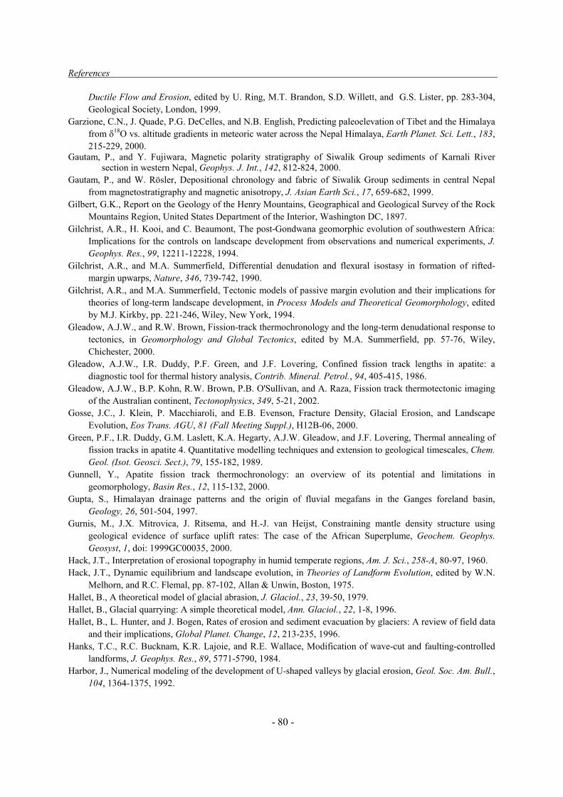
References
- 80 -
Ductile Flow and Erosion, edited by U. Ring, M.T. Brandon, S.D. Willett, and G.S. Lister, pp. 283-304, Geological Society, London, 1999.
Garzione, C.N., J. Quade, P.G. DeCelles, and N.B. English, Predicting paleoelevation of Tibet and the Himalaya from �18O vs. altitude gradients in meteoric water across the Nepal Himalaya, Earth Planet. Sci. Lett., 183, 215-229, 2000.
Gautam, P., and Y. Fujiwara, Magnetic polarity stratigraphy of Siwalik Group sediments of Karnali River section in western Nepal, Geophys. J. Int., 142, 812-824, 2000.
Gautam, P., and W. Rösler, Depositional chronology and fabric of Siwalik Group sediments in central Nepal from magnetostratigraphy and magnetic anisotropy, J. Asian Earth Sci., 17, 659-682, 1999.
Gilbert, G.K., Report on the Geology of the Henry Mountains, Geographical and Geological Survey of the Rock Mountains Region, United States Department of the Interior, Washington DC, 1897.
Gilchrist, A.R., H. Kooi, and C. Beaumont, The post-Gondwana geomorphic evolution of southwestern Africa: Implications for the controls on landscape development from observations and numerical experiments, J. Geophys. Res., 99, 12211-12228, 1994.
Gilchrist, A.R., and M.A. Summerfield, Differential denudation and flexural isostasy in formation of rifted-margin upwarps, Nature, 346, 739-742, 1990.
Gilchrist, A.R., and M.A. Summerfield, Tectonic models of passive margin evolution and their implications for theories of long-term landscape development, in Process Models and Theoretical Geomorphology, edited by M.J. Kirkby, pp. 221-246, Wiley, New York, 1994.
Gleadow, A.J.W., and R.W. Brown, Fission-track thermochronology and the long-term denudational response to tectonics, in Geomorphology and Global Tectonics, edited by M.A. Summerfield, pp. 57-76, Wiley, Chichester, 2000.
Gleadow, A.J.W., I.R. Duddy, P.F. Green, and J.F. Lovering, Confined fission track lengths in apatite: a diagnostic tool for thermal history analysis, Contrib. Mineral. Petrol., 94, 405-415, 1986.
Gleadow, A.J.W., B.P. Kohn, R.W. Brown, P.B. O'Sullivan, and A. Raza, Fission track thermotectonic imaging of the Australian continent, Tectonophysics, 349, 5-21, 2002.
Gosse, J.C., J. Klein, P. Macchiaroli, and E.B. Evenson, Fracture Density, Glacial Erosion, and Landscape Evolution, Eos Trans. AGU, 81 (Fall Meeting Suppl.), H12B-06, 2000.
Green, P.F., I.R. Duddy, G.M. Laslett, K.A. Hegarty, A.J.W. Gleadow, and J.F. Lovering, Thermal annealing of fission tracks in apatite 4. Quantitative modelling techniques and extension to geological timescales, Chem. Geol. (Isot. Geosci. Sect.), 79, 155-182, 1989.
Gunnell, Y., Apatite fission track thermochronology: an overview of its potential and limitations in geomorphology, Basin Res., 12, 115-132, 2000.
Gupta, S., Himalayan drainage patterns and the origin of fluvial megafans in the Ganges foreland basin, Geology, 26, 501-504, 1997.
Gurnis, M., J.X. Mitrovica, J. Ritsema, and H.-J. van Heijst, Constraining mantle density structure using geological evidence of surface uplift rates: The case of the African Superplume, Geochem. Geophys. Geosyst, 1, doi: 1999GC00035, 2000.
Hack, J.T., Interpretation of erosional topography in humid temperate regions, Am. J. Sci., 258-A, 80-97, 1960. Hack, J.T., Dynamic equilibrium and landscape evolution, in Theories of Landform Evolution, edited by W.N.
Melhorn, and R.C. Flemal, pp. 87-102, Allan & Unwin, Boston, 1975. Hallet, B., A theoretical model of glacial abrasion, J. Glaciol., 23, 39-50, 1979. Hallet, B., Glacial quarrying: A simple theoretical model, Ann. Glaciol., 22, 1-8, 1996. Hallet, B., L. Hunter, and J. Bogen, Rates of erosion and sediment evacuation by glaciers: A review of field data
and their implications, Global Planet. Change, 12, 213-235, 1996. Hanks, T.C., R.C. Bucknam, K.R. Lajoie, and R.E. Wallace, Modification of wave-cut and faulting-controlled
landforms, J. Geophys. Res., 89, 5771-5790, 1984. Harbor, J., Numerical modeling of the development of U-shaped valleys by glacial erosion, Geol. Soc. Am. Bull.,
104, 1364-1375, 1992.

References
- 81 -
Hardy, S., C. Duncan, J. Masek, and D. Brown, Minimum work, fault activity and the growth of critical wedges in fold and thrust belts, Basin Res., 10, 365-373, 1998.
Harrison, T.M., P. Copeland, S.A. Hall, J. Quade, S. Burner, T.P. Ojha, and W.S.F. Kidd, Isotopic preservation of Himalayan/Tibetan uplift, denudation, and climatic histories in two molasse deposits, J. Geol., 100, 157-173, 1993.
Hay, W.W., Detrital sediment fluxes from continents to oceans, Chem. Geol., 145, 287-323, 1998. Hay, W.W., E. Soeding, R.M. DeConto, and C.N. Wold, The Late Cenozoic uplift - climate change paradox, Int.
J. Earth Sci., 91, 746-774, 2002. Hilley, G.E., and M.R. Strecker, Steady-state erosion of critical Coulomb wedges with applications to Taiwan
and the Himalaya, Geophys. Res. Abstracts, 5, 04581, 2003. Hinderer, M., Late Quaternary denudation of the Alps, valley and lake fillings and modern river loads, Geodin.
Acta, 14, 231-263, 2001. Hodges, K.V., J.M. Hurtado, and K.X. Whipple, Southward extrusion of Tibetan crust and its effect on
Himalayan tectonics, Tectonics, 20, 799-809, 2001. Hoffman, P.F., and J.P. Grotzinger, Orographic precipitation, erosional unloading, and tectonic style, Geology,
21, 195-198, 1993. Hooke, R.L., Positive feedbacks associated with erosion of glacial cirques and overdeepenings, Geol. Soc. Am.
Bull., 103, 1364-1375, 1991. House, M.A., K.A. Farley, and B.P. Kohn, An empirical test of helium diffusion in apatite: borehole data from
the Otway basin, Australia, Earth Planet. Sci. Lett., 170, 463-474, 1999. House, M.A., B.P. Wernicke, and K.A. Farley, Dating topography of the Sierra Nevada, California, using apatite
(U-Th)/He ages, Nature, 396, 66-69, 1998. House, M.A., B.P. Wernicke, and K.A. Farley, Paleo-geomorphology of the Sierra Nevada, California, from (U-
Th)/He ages in apatite, Am. J. Sci., 301, 77-102, 2001. Hovius, N., Controls on sediment supply by large rivers, in Relative Role of Eustacy, Climate and Tectonics in
Continental Rocks, edited by K.W. Shanley, and P.J. McCabe, pp. 3-16, Society of Economic Paleontologists and Mineralogists, 1998.
Hovius, N., C.P. Stark, and P.A. Allen, Sediment flux from a mountain belt derived by landslide mapping, Geology, 25, 231-234, 1997.
Hovius, N., C.P. Stark, H.-T. Chu, and J.-C. Lin, Supply and removal of sediment in a landslide-dominated mountain belt: Central Range, Taiwan, J. Geol., 108, 73-89, 2000.
Howard, A.D., Long profile development of bedrock channels: Interaction of weathering, mass wasting, bed erosion, and sediment transport, in Rivers over Rock: Fluvial Processes in Bedrock Channels, edited by K.J. Tinkler, and E.E. Wohl, pp. 297-319, American Geophysical Union, 1998.
Howard, A.D., W.E. Dietrich, and M.A. Seidl, Modeling fluvial erosion on regional to continental scales, J. Geophys. Res., 99, 13971-13986, 1994.
Huang, J., and D.L. Turcotte, Fractal mapping of digitized images: Application to the topography of Arizona and comparisons with synthetic images, J. Geophys. Res., 94, 7491-7495, 1989.
Humphrey, N.F., and C.F. Raymond, Hydrology, erosion and sediment production in a surging glacier, Variegated Glacier, Alaska, 1982-1983, J. Glaciol., 40, 539-552, 1994.
Hurford, A.J., Uplift and cooling pathways derived from fission track analysis and mica dating: a review, Geol. Rundschau, 80, 349-368, 1991.
Hurtrez, J.-E., F. Lucazeau, J. Lavé, and J.-P. Avouac, Investigation of the relationships between basin morphology, tectonic uplift, and denudation from the study of an active fold belt in the Siwalik Hills, central Nepal, J. Geophys. Res., 104, 12779-12796, 1999.
Huyghe, P., M. Dietrich, P. Andreo, and F. Guyoton, A vibroseis multichannel seismic reflection survey of the post-glacial alluviums of an alpine valley (Bourg d'Oisans, France), Geophys. Res. Abstr., 3, 1460, 2001a.
Huyghe, P., A. Galy, J.L. Mugnier, and C. France-Lanord, Propagation of the thrust system and erosion in the Lesser Himalaya: Geochemical and sedimentological evidence, Geology, 29, 1007–1010, 2001b.

References
- 82 -
Jackson, J., R. Norris, and J. Youngson, The structural evolution of active fault and fold systems in central Otago, New Zealand: evidence revealed by drainage patterns, J. Struct. Geol., 18, 217-234, 1996.
Jackson, J., J.-F. Ritz, L. Siame, G. Raisbeck, F. Yiou, R. Norris, J. Youngson, and E. Bennett, Fault growth and landscape development rates in Otago, New Zealand, using in situ cosmogenic 10Be, Earth Planet. Sci. Lett., 195, 185-193, 2002.
Jackson, M., and R. Bilham, Constraints on Himalayan deformation inferred from vertical velocity fields in Nepal and Tibet, J. Geophys. Res., 99, 13897-13912, 1994.
Jamieson, S.S.R., H.D. Sinclair, L.A. Kirstein, and R.S. Purves, Tectonic forcing of longitudinal valleys in the Himalaya: morphological analysis of the Ladakh Batholith, North India, Geomorphology, in press, 2003.
Jones, J.G., and J.J. Veevers, Mesozoic origins and antecedents of Australia's Eastern Highlands, J. Geol. Soc. Australia, 30, 305-322, 1983.
Jouanne, F., G. Ménard, and X. Darmendrail, Present-day vertical displacements in the north-western Alps and southern Jura Mountains : Data from levelling comparisons, Tectonics, 14, 606-616, 1995.
Jouanne, F., J.L. Mugnier, M.R. Pandey, J.F. Gamond, P. Le Fort, L. Serrurier, C. Vigny, J.P. Avouac, and Idylhim members, Oblique convergence in the Himalayas of Western Nepal deduced form preliminary results of GPS measurements, Geophys. Res. Lett., 26, 1933-1936, 1999.
Keller, E.A., L. Gurrola, and T.E. Tierney, Geomorphic criteria to determine direction of lateral propagation of reverse faulting and folding, Geology, 27, 515-518, 1999.
Ketcham, R.A., R.A. Donelick, and W.D. Carlson, Variability of apatite fission-track annealing kinetics: III. Extrapolation to geological time scales, Am. Mineral., 84, 1235-1255, 1999.
King, L.C., The Morphology of the Earth, 726 pp., Oliver & Boyd, Edinburgh/London, 1962. Kirby, E., and K.X. Whipple, Quantifying differential rock-uplift rates via stream profile analysis, Geology, 29,
415-418, 2001. Kirchner, J.W., Statistical inevitability of Horton's laws and the apparent randomness of stream channel
networks, Geology, 21, 591-594, 1993. Kirkbride, M., and D. Matthews, The role of fluvial and glacial erosion in landscape evolution: The Ben Ohau
Range, New Zealand, Earth Surf. Proc. Landf., 22, 317-327, 1997. Kohn, B.P., D.X. Belton, R.W. Brown, A.J.W. Gleadow, P.F. Green, and J.F. Lovering, Comment on:
"Experimental evidence for the pressure dependence of fission track annealing in apatite" by A.S. Wendt et al. [Earth Planet. Sci. Lett. 201 (2002) 593–607], Earth Planet. Sci. Lett., 215, 299-306, 2003.
Kooi, H., and C. Beaumont, Escarpment evolution on high-elevation rifted margins; insights derived from a surface processes model that combines diffusion, advection and reaction, J. Geophys. Res., 99, 12191-12210, 1994.
Kooi, H., and C. Beaumont, Large-scale geomorphology: Classical concepts reconciled and integrated with contemporary ideas via a surface-processes model, J. Geophys. Res., 101, 3361-3386, 1996.
Koons, P.O., The topographic evolution of collisional mountain belts: A numerical look at the Southern Alps, New Zealand, Am. J. Sci., 289, 1041-1069, 1989.
Koons, P.O., Modeling the topographic evolution of collisional belts, Ann. Rev. Earth Planet. Sci., 23, 375-408, 1995.
Koons, P.O., P.K. Zeitler, C.P. Chamberlain, D. Craw, and A.S. Meltzer, Mechanical links between erosion and metamorphism in Nanga Parbat, Pakistan Himalaya, Am. J. Sci., 302, 749–773, 2002.
Koppes, M.N., and B. Hallet, Influence of rapid glacial retreat on the rate of erosion by tidewater glaciers, Geology, 30, 47–50, 2002.
Kuhlemann, J., W. Frisch, B. Székely, I. Dunkl, and M. Kázmér, Post-collisional sediment budget history of the Alps: tectonic versus climatic control, Int. J. Earth Sci., 91, 818-837, 2002.
Lague, D., and P. Davy, Constraints on the long-term colluvial erosion law by analyzing slope-area relationships at various tectonic uplift rates in the Siwaliks Hills (Nepal), J. Geophys. Res., 108, 2129, doi:10.1029/2002JB001893, 2003.
Lal, D., Cosmic ray labelling of erosion surfaces: in situ nuclide production rates and erosion models, Earth Planet. Sci. Lett., 104, 424-439, 1991.

References
- 83 -
Lambeck, K., and R. Stephenson, The post-Paleozoic uplift history of south-eastern Australia, Austr. J. Earth Sci., 33 , 253-270, 1986.
Larson, K.M., R. Bürgmann, R. Bilham, and J.T. Freymueller, Kinematics of the India-Eurasia collision zone from GPS measurements, J. Geophys. Res., 104, 1077-1093, 1999.
Laslett, G.M., P.F. Green, I.R. Duddy, and A.J.W. Gleadow, Thermal annealing of fission tracks in apatite 2. A quantitative analysis, Chem. Geol. (Isot. Geosci. Sect.), 65, 1-13, 1987.
Lavé, J., and J.P. Avouac, Active folding of fluvial terraces across the Siwaliks Hills (Himalayas of central Nepal), J. Geophys. Res., 105, 5735-5770, 2000.
Lavé, J., and J.P. Avouac, Fluvial incision and tectonic uplift across the Himalayas of central Nepal, J. Geophys. Res., 106, 25561-25593, 2001.
Lavé, J., and D.W. Burbank, Denudation rates and patterns in the Transverse Ranges, Southern California, J. Geophys. Res., submitted.
Leeder, M.R., Denudation, vertical crustal movements and sedimentary basin infill, Geol. Rundsch., 80, 441-458, 1991.
Leland, J., M.R. Reid, D.W. Burbank, R. Finkel, and M. Caffee, Incision and differential bedrock uplift along the Indus River near Nanga Parbat, Pakistan Himalaya, from 10Be and 26Al exposure age dating of bedrock straths, Earth Planet. Sci. Lett., 154, 93-107, 1998.
Lelarge Medeiros Vignol, M.L., Thermochronologie par la méthode des traces de fission d'une marge passive (dôme de Ponto Grossa, SE Brésil) et au sein d'une chaîne de collision (zone externe de l'arc alpin, France), Ph.D. thesis, Université Joseph Fourier, Grenoble, 1993.
Lifton, N.A., and C.G. Chase, Tectonic, climatic and lithologic influences on landscape fractal dimension and hypsometry: implications for landscape evolution in the San Gabriel Mountains, California, Geomorphology, 5, 77-114, 1992.
Lliboutry, L., Traité de Glaciologie, 1040 pp., Editions Masson, Paris, 1964. Lonergan, L., and C. Johnson, Reconstructing orogenic exhumation histories using synorogenic detrital zircons
and apatites: an example from the Betic Cordillera, SE Spain, Basin Res., 10, 353-364, 1998. Lovera, O.M., F.M. Richter, and T.M. Harrison, 40Ar/39Ar thermochronology for slowly cooled samples having a
distribution of diffusion domain sizes, J. Geophys. Res., 94, 17917-17936, 1989. Lyon-Caen, H., and P. Molnar, Gravity anomalies, flexure of the Indian plate and the structure, support and
evolution of the Himalaya and Ganga Basin, Tectonics, 4, 513-538, 1985. MacGregor, K.R., R.S. Anderson, S.P. Anderson, and E.D. Waddington, Numerical simulations of glacial-valley
longitudinal profile evolution, 28, 1071-1074, 2000. Malavieille, J., Modélisation expérimentale des chevauchements imbriqués: application aux chaînes de
montagnes, Bull. Soc. Géol. France, 26, 129-138, 1984. Mandier, P., Signification dynamique et climatique des formations et terrasses fluviatiles Quaternaires dans les
Alpes et leur périphérie, Bull. Assoc. Fr. Et. Quat., 1984, 113-118, 1984. Manktelow, N.S., and B. Grasemann, Time-dependent effects of heat advection and topography on cooling
histories during erosion, Tectonophysics, 270, 167-195, 1997. Martinod, J., F. Jouanne, J. Taverna, G. Ménard, J.F. Gamond, X. Darmendrail, J.C. Notter, and C. Basile,
Present-day deformation of the Dauphiné (SE France) Alpine and Subalpine massifs, Geophys. J. Int., 127, 189-200, 1996.
Masek, J.G., and C.C. Duncan, Minimum-work mountain building, J. Geophys. Res., 103, 907-917, 1998. McDougall, I., and T.M. Harrison, Geochronology and Thermochronology by the 40Ar/39Ar Method, 210 pp.,
Oxford University Press, New York, 1988. Meigs, A., and J. Sauber, Southern Alaska as an example of the long-term consequences of mountain building
under the influence of glaciers, Quat. Sci. Rev., 19, 1543-1562, 2000. Merrand, Y., and B. Hallet, Climatic Controls on Glacial Erosion and Sediment Transfer: Modeling a South
Alaskan Glacial Basin from Range Divide to Shelf Break, Eos Trans. AGU, 82 (Fall Meeting Suppl.), OS41B-08, 2001.
Métivier, F., Y. Gaudemer, P. Tapponier, and M. Klein, Mass accumulation rates in Asia during the Cenozoic, Geoophys. J. Int., 137, 280-318, 1999.

References
- 84 -
Michalski, I., and M. Soom, The Alpine thermo-tectonic evolution of the Aar and Gotthard massifs, central Switzerland: Fission track ages on zircon and apatite and K-Ar mica ages, Schweiz. Mineral. Petrogr. Mitt., 70, 373-387, 1990.
Milliman, J.D., and R.H. Meade, World-wide delivery of river sediment to the oceans, J. Geol., 91, 1-21, 1983. Milliman, J.D., and J.P. Syvitski, Geomorphic / tectonic control of sediment discharge to the oceans: The
importance of small mountainous rivers, J. Geol., 100, 525-544, 1992. Millot, R., J. Gaillardet, B. Dupré, and C.J. Allègre, The global control of silicate weathering rates and the
coupling with physical erosion: new insights from rivers of the Canadian Shield, Earth Planet. Sci. Lett., 196, 83-98, 2002.
Molnar, P., and P. England, Late Cenozoic uplift of mountain ranges and global climate change: chicken or egg?, 346, 29-34, 1990.
Molnar, P., P. England, and J. Martinod, Mantle dynamics, uplift of the Tibetan Plateau, and the Indian monsoon, Rev. Geophys., 31, 357-396, 1993.
Montgomery, D.R., Valley incision and the uplift of mountain peaks, J. Geophys. Res., 99, 13913-13921, 1994. Montgomery, D.R., Valley formation by fluvial and glacial erosion, Geology, 30, 1047-1050, 2002. Montgomery, D.R., G. Balco, and S.D. Willett, Climate, tectonics, and the morphology of the Andes, Geology,
29, 579–582, 2001. Montgomery, D.R., and M.T. Brandon, Topographic controls on erosion rates in tectonically active mountain
ranges, Earth Planet. Sci. Lett., 201, 481-489, 2002. Montjuvent, G., La transfluence Durance-Isère. Essai de synthèse du Quaternaire du bassin du Drac (Alpes
françaises), Géol. Alp., 49, 57-118, 1973. Montjuvent, G., Considérations sur le relief glaciaire à propos des Alpes du Dauphiné, Rev. Géogr. Phys. Géol.
Dyn., 16, 465-502, 1974. Montjuvent, G., Le Drac. Morphologie, stratigraphie et chronologie quaternaires d'un bassin alpin, 433 pp.,
Comité National de la Recherche Scientifique, Paris, 1978. Moore, M.E., A.J.W. Gleadow, and J.F. Lovering, Thermal evolution of rifted continental margins: new
evidence from fission tracks in basement apatites from southeastern Australia, Earth Planet. Sci. Lett., 78, 255-270, 1986.
Moretti, I., and D.L. Turcotte, A model for erosion, sedimentation and flexure with applications to New Caledonia, J. Geodyn., 3, 155-168, 1985.
Mugnier, J.L., P. Baby, B. Colletta, P. Vinour, P. Bale, and P. Leturmy, Thrust geometry controlled by erosion and sedimentation: A view from analogue models, Geology, 25, 427-430, 1997.
Mugnier, J.L., P. Huyghe, P. Leturmy, and F. Jouanne, Episodicity and rates of thrust sheet motion in the Himalayas (western Nepal), in Thrust Tectonics and Petroleum Systems, edited by K.C. McClay, in press, 2003.
Mugnier, J.L., P. Leturmy, P. Huyghe, and E. Chalaron, The Siwaliks of western Nepal: II - Mechanics of the thrust wedge, J. Asian Earth Sci., 17, 643-657, 1999a.
Mugnier, J.L., P. Leturmy, G. Mascle, P. Huyghe, E. Chalaron, G. Vidal, L. Husson, and B. Delcaillau, The Siwaliks of western Nepal: I - Geometry and kinematics, J. Asian Earth Sci., 17, 629-642, 1999b.
Najman, Y., M. Pringle, M. Bickle, E. Garzanti, D. Burbank, S. Ando, and N. Brozovic, Non-steady-state exhumation of the Higher Himalaya, N.W. India: insights from a combined isotopic and sedimentological approach, Geophys. Res. Abstracts, 5, 04551, 2003.
Nakayama, K., and P.D. Ulak, Evolution of fluvial style in the Siwalik Group in the foothills of the Nepal Himalaya, Sed. Geol., 125, 205-224, 1999.
Nott, J.F., R.W. Young, and I. McDougall, Wearing down, wearing back and gorge extension in the long-term evolution of a highland mass: Quantitative evidence from the Shoalhaven catchment, southeast Australia, J. Geol., 104, 224-232, 1996.
Oberlander, T., The Zagros Streams, 168 pp., Syracuse University Press, Syracuse, 1965. Oberlander, T.M., Origin of drainage transverse to structures in orogens, in Tectonic Geomorphology, edited by
M. Morisawa, and J.T. Hack, pp. 155-182, Allan & Unwin, Boston, 1985.

References
- 85 -
Oerlemans, J., Numerical experiments on large-scale glacial erosion, Z. Gletscherk. Glazialgeol., 20, 107-126, 1984.
Oerlemans, J., Climate sensitivity of glaciers in southern Norway: application of an energy-balance model to Nigardsbreen, Hellstugubreen and Alfotbreen, J. Glaciol., 38, 223-232, 1992.
Ollier, C.D. (ed.), Morphotectonics of passive continental margins, Zeitschrift für Geomorphologie Supplementsband, 54, 120 pp., 1985.
Ollier, C.D., and M.E. Marker, The Great Escarpment of southern Africa, Z. Geomorph. Suppl., 54, 37-56, 1985.
Ollier, C.D., and C.F. Pain, Equating the basal unconformity with the palaeoplain: a model for passive margins, Geomorphology, 19, 1-15, 1997.
Oreskes, N., K. Shrader-Frechette, and K. Belitz, Verification, validation, and confirmation of numerical models in the earth sciences, Science, 263, 641-646, 1994.
Parker, G., and N. Izumi, Purely erosional cyclic and solitary steps created by flow over a cohesive bed, J. Fluid Mech., 419, 203-238, 2000.
Partridge, T.C., and R.R. Maud, Geomorphic evolution of southern Africa since the Mesozoic, S. Afr. J. Geol., 90, 179-208, 1987.
Paterson, W.S.B., The Physics of Glaciers, 480 pp., Pergamon, Tarrytown, New York, 1994. Pavlis, T.L., M.W. Hamburger, and G.L. Pavlis, Erosional processes as a control on the structural evolution of
an actively deforming fold and thrust belt: An example from the Pamir-Tien Shan region, central Asia, Tectonics, 16, 810-822, 1997.
Pazzaglia, F.J., and M.T. Brandon, A fluvial record of long-term steady-state uplift and erosion across the Cascadia forearc high, western Washington State, Am. J. Sci., 301, 385-431, 2001.
Penck, W., Die Morphologische Analyse: Ein Kapital der Physikalischen Geologie, Engelhorn, Stuttgart, 1924. Perg, L.A., R.S. Anderson, and R.C. Finkel, Use of a new 10Be and 26Al inventory method to date marine
terraces, Santa Cruz, California, USA, Geology, 29, 879-882, 2001. Persano, C., F.M. Stuart, P. Bishop, and D.N. Barfod, Apatite (U-Th)/He age constraints on the development of
the Great Escarpment on the southeastern Australian passive margin, Earth Planet. Sci. Lett., 200, 79-90, 2002.
Peysson, E., Age et modalités de la formation du relief du massif du Pelvoux : Influences tectoniques et climatiques, MSc. (DEA) Thesis, 34 pp., Université Joseph Fourier, Grenoble, 2000.
Pinet, P., and M. Souriau, Continental erosion and large-scale relief, Tectonics, 7, 563-582, 1988. Quade, J., J.M.L. Cater, T.P. Ojha, J. Adam, and T.M. Harrison, Late Miocene environmental change in Nepal
and the northern Indian subcontinent: Stable isotopic evidence from paleosols, Geol. Soc. Am. Bull., 107, 1381-1397, 1995.
Rahl, J.M., P.W. Reiners, I.H. Campbell, S. Nicolescu, and C.M. Allen, Combined single-grain (U-Th)/He and U/Pb dating of detrital zircons from the Navajo Sandstone, Utah, Geology, 31, 761-764, 2003.
Raymo, M.W., and W.F. Ruddiman, Tectonic forcing of late Cenozoic climate, Nature, 359, 117-122, 1992. Reiners, P.W., (U-Th)/He chronometry experiences a renaissance, EOS, Trans. Am. Geophys. Union, 83, 21-27,
2002. Repka, J.L., R.S. Anderson, and R. Finkel, Cosmogenic dating of fluvial terraces, Fremont River, Utah, Earth
Planet. Sci. Lett., 152, 59-73, 1997. Rhodes, B.L., and C.E. Thorn, The Scientific Nature of Geomorphology: Proceedings of the 27th Binghampton
Symposium in Geomorphology, 481 pp., Wiley, Chichester, 1996. Riebe, C.S., J.W. Kirchner, D.E. Granger, and R.C. Finkel, Strong tectonic and weak climatic control of long-
term chemical weathering rates, Geology, 29, 511-514, 2001. Ring, U., M.T. Brandon, S.D. Willett, and G.S. Lister, Exhumation processes, in Exhumation Processes:
Normal Faulting, Ductile Flow and Erosion, edited by U. Ring, M.T. Brandon, S.D. Willett, and G.S. Lister, pp. 1-27, Geological Society, London, 1999.
Robinson, D.M., P.G. DeCelles, P.J. Patchett, and C.N. Garzione, The kinematic evolution of the Nepalese Himalaya interpreted from Nd isotopes, Earth Planet. Sci. Lett., 192, 507-521, 2001.

References
- 86 -
Roering, J.J., J.W. Kirchner, and W.E. Dietrich, Evidence for nonlinear, diffusive sediment transport on hillslopes and implications for landscape morphology, Water Res. Res., 35, 853-870, 1999.
Roering, J.J., J.W. Kirchner, L.S. Sklar, and W.E. Dietrich, Hillslope evolution by nonlinear creep and landsliding: An experimental study, Geology, 29, 143-146, 2001.
Rohrman, M., P.A.M. Andriessen, and P.A. van der Beek, The relationship between basin and margin thermal evolution assessed by fission track thermochronology: an application to offshore southern Norway, Basin Res., 8, 45-63, 1996.
Rowley, D.B., R.T. Pierrehumbert, and B.S. Currie, A new approach to stable isotope-based paleoaltimetry: implications for paleoaltimetry and paleohypsometry of the High Himalaya since the Late Miocene, Earth Planet. Sci. Lett., 188, 253-268, 2001.
Rutherford, E., Some cosmical aspects of radioactivity, J.R. Astr. Soc. Canada, 145-165, 1907. Sabil, N., La datation par traces de fission : aspects méthodologiques et applications thermochronologiques en
contextes alpins et de marge continentale, Ph.D. thesis, Université Joseph Fourier, Grenoble, 1995. Sambridge, M., Geophysical inversion with a neighbourhood algorithm - I. Searching a parameter space,
Geophys. J. Int., 138, 479-494, 1999a. Sambridge, M., Geophysical inversion with a neighbourhood algorithm - II. Appraising the ensemble, Geophys.
J. Int., 138, 727-746, 1999b. Schlunegger, F., Controls of surface erosion on the evolution of the Alps: constraints from the stratigraphies of
the adjacent foreland basins, Int. J. Earth Sci., 88, 285-304, 1999. Schlunegger, F., and M. Hinderer, Pleistocene/Holocene climate change, re-establishment of fluvial drainage
network and increase in relief in the Swiss Alps, Terra Nova, 15, 88-95, 2003. Schlunegger, F., and G. Simpson, Possible erosional control on lateral growth of the European Central Alps,
Geology, 30, 907-910, 2002. Schmidt, K.M., and D.R. Montgomery, Limits to relief, Science, 270, 617-620, 1995. Seidl, M.A., and W.E. Dietrich, The problem of channel erosion into bedrock, in Functional Geomorphology,
edited by K.-H. Schmidt, and J. De Ploey, pp. 101-124, 1992. Seidl, M.A., W.E. Dietrich, and J.W. Kirchner, Longitudinal profile development into bedrock: an analysis of
Hawaiian channels, J. Geol., 102, 457-474, 1994. Seidl, M.A., J.K. Weissel, and L.F. Pratson, The kinematics and pattern of escarpment retreat across the rifted
continental margin of SE Australia, Basin Res., 8, 301-316, 1996. Seward, D., M. Ford, J. Bürgisser, H. Lickorish, E.A. Williams, and L.D. Meckel III, Preliminary results of
fission-track analyses in the southern Pelvoux area, SE France, in 3rd Workshop on Alpine Geological Studies, Biella-Oropa September 29 - October 1, 1997, edited by G. Gosso, F. Jadoul, M. Sella, and M.I. Spalla, pp. 25-31, 1999.
Seward, D., and N.S. Mancktelow, Neogene kinematics of the central and western Alps: Evidence from fission-track dating, 22, 803-806, 1994.
Siame, L.L., D.L. Bourlès, M. Sébrier, O. Bellier, J. Carlos Castano, M. Araujo, M. Perez, G.M. Raisbeck, and F. Yiou, Cosmogenic dating ranging from 20 to 700 ka of a series of alluvial fan surfaces affected by the El Tigre fault, Argentina, Geology, 25, 975-978, 1997.
Sikirdji, L., Etude Sédimentologique et géotechnique des alluvions déposées dans la retenue du Chambon (vallée de la Romanche - Isère) après 45 ans d'exploitation, PhD thesis, Université Scientifique et Médicale de Grenoble, 1982.
Singh, S.K., and C. France-Lanord, Tracing the distribution of erosion in the Brahmaputra watershed from isotopic compositions of stream sediments, Earth Planet. Sci. Lett., 202, 645-662, 2002.
Sklar, L., and W.E. Dietrich, River longitudinal profiles and bedrock incision models: Stream power and the influence of sediment supply, in Rivers over Rock: Fluvial Processes in Bedrock Channels, edited by K.J. Tinkler, and E.E. Wohl, pp. 237-260, American Geophysical Union, 1998.
Sklar, L., and W.E. Dietrich, Sediment and rock strength controls on river incision into bedrock, Geology, 29, 1087-1090, 2001.

References
- 87 -
Slingerland, R., S.D. Willett, and H. Hennessey, A new fluvial bedrock erosion model based on the work-energy principle, EOS Trans. AGU, 78 (Fall Meeting Suppl.), 299, 1997.
Slingerland, R., S.D. Willett, and N. Hovius, Slope-area scaling as a test of fluvial incision laws, EOS Trans. AGU, 79 (Fall Meeting Suppl.), F358, 1998.
Small, E., and R.S. Anderson, Geomorphically driven late Cenozoic rock uplift in the Sierra Nevada, California, Science, 270, 277-280, 1995.
Small, E., and R.S. Anderson, Pleistocene relief production in Laramide mountain ranges, western Unites States, Geology, 26, 123-126, 1998.
Small, E.E., R.S. Anderson, J.L. Repka, and R. Finkel, Erosion rates of alpine bedrock summit surfaces deduced from in situ 10Be and 26Al, Earth Planet. Sci. Lett., 150, 413-425, 1997.
Snyder, N.P., K.X. Whipple, G.E. Tucker, and D.J. Merrits, Landscape response to tectonic forcing: Digital elevation model analysis of stream profiles in the Mendocino triple junction region, northern California, Geol. Soc. Am. Bull., 112, 1250-1263, 2000.
Snyder, N.P., K.X. Whipple, G.E. Tucker, and D.J. Merrits, Importance of a stochastic distribution of floods and erosion thresholds in the bedrock river incision problem, J. Geophys. Res., 108, 2117, doi:10.1029/2001JB001655, 2003.
Spicer, R.A., N.B.W. Harris, M. Widdowson, A.B. Herman, S. Guo, P.J. Valdes, J.A. Wolfe, and S.P. Kelley, Constant elevation of southern Tibet over the past 15 million years, Nature, 421, 622-624, 2003.
Spiegel, C., W. Siebel, J. Kuhlemann, and W. Frisch, Towards a comprehensive provenance analysis: A multimethod approach and its implications for the evolution of the Central Alps, in Detrital Thermochronology — Exhumation and Landscape Evolution in Mountain Belts, edited by M. Bernet, and C. Spiegel, Geol. Soc. Am. Spec. Publ., in press, 2003.
Stark, C.P., Cluster growth modeling of plateau erosion, J. Geophys. Res., 99, 13,957-13,970, 1994. Stephenson, R.A., and K. Lambeck, Erosion-isostatic rebound models for uplift: an application to south-eastern
Australia, Geophys. J. R. Astron. Soc., 82, 31-55, 1985. Stock, J., and W.E. Dietrich, Valley incision by debris flows: Evidence of a topographic signature, Water Res.
Res., 39, 1089, doi:10.1029/2001WR001057, 2003. Stock, J.D., and D.R. Montgomery, Estimating paleorelief from detrital mineral ages, Basin Res., 8, 317-327,
1996. Stock, J.D., and D.R. Montgomery, Geologic constraints on bedrock river incision using the stream power law,
J. Geophys. Res., 104, 4983-4993, 1999. Stockli, D.F., K.A. Farley, and T.A. Dumitru, Calibration of the apatite (U-Th)/He thermochronometer on an
exhumed fault block, White Mountains, California, Geology, 28, 961-1056, 2000. Stolar, D.B., G.H. Roe, and S.D. Willett, Coupled erosional and tectonic models, Penrose Conference:
Tectonics, Climate and Landscape Evolution, Taroko National Park, Taiwan, 2003. Stone, J.O., J.M. Evans, L.K. Fifield, G.L. Allan, R.G. Cresswell, and K. Lambeck, A lategacial age for the
Main Rock Platform, western Scotland, Geology, 24, 707-710, 1996. Strahler, A.N., Hypsometric (area-altitude) analysis of erosional topography, Geol. Soc. Am. Bull., 63, 1117-
1142, 1952. Strecker, M.R., G.E. Hilley, J.R. Arrowsmith, and I. Coutand, Differential structural and geomorphic mountain-
front evolution in an active continental collision zone: The northwest Pamir, southern Kyrgyzstan, Geol. Soc. Am. Bull., 115, 166-181, 2003.
Stüwe, K., and M. Hintermüller, Topography and isotherms revisited: the influence of laterally migrating drainage divides, Earth Planet. Sci. Lett., 184, 287-303, 2000.
Stüwe, K., L. White, and R.W. Brown, The influence of eroding topography on steady-state isotherms. Application to fission track analysis, Earth Planet. Sci. Lett., 124, 63-74, 1994.
Sue, C., and P. Tricart, Neogene to ongoing normal faulting in the Inner western Alps: A major evolution of the late alpine tectonics, Tectonics, 22, 1050, doi:10.1029/2002TC001426, 2003.
Summerfield, M.A., Global Geomorphology; An introduction to the study of landforms, Wiley, 1991a.
References
- 88 -
Summerfield, M.A., Sub-aerial denudation of passive margins: regional elevation versus local relief models, Earth Planet. Sci. Lett., 102, 460-469, 1991b.
Summerfield, M.A. (Ed.), Geomorphology and Global Tectonics, Wiley, Chichester, 2000. Summerfield, M.A., and R.W. Brown, Geomorphic factors in the interpretation of fission-track data, in
Advances in Fission-Track Geochronology, edited by P. Van den haute, and F. De Corte, pp. 269-284, Kluwer, Dordrecht, 1998.
Summerfield, M.A., and N.J. Hulton, Natural controls of fluvial denudation rates in major world drainage basins, J. Geophys. Res., 99, 13871-13883, 1994.
Suppe, J., Geometry and kinematics of fault-bend folding, Am. J. Sci., 283, 684-721, 1983. Suppe, J., and D.A. Medwedeff, Geometry and kinematics of fault-propagation folding, Eclog. geol. Helv., 83,
409-454, 1990. Szulc, A.G., Y. Najman, M. Pringle, M. Bickle, H. Chapman, E. Garzanti, H. Sinclair, T.P. Ojha, and P.G.
DeCelles, Himalayan tectonic evolution determined from the sedimentary record, Nepal, Geophys. Res. Abstracts, 5, 00265, 2003.
Tatar, M., D. Hatzfeld, J. Martinod, A. Walpersdorf, M. Ghafori-Ashtiany, and J. Chéry, The present-day deformation of the central Zagros from GPS measurements, Geophys. Res. Lett., 29, 1927, doi:10.1029/2002GL015427, 2002.
ten Brink, U., and T. Stern, Rift flank uplifts and hinterland basins: Comparison of the Transantarctic Mountains with the Great Escarpment of southern Africa, J. Geophys. Res., 97, 569-585, 1992.
Tomkin, J.H., M.T. Brandon, F.J. Pazzaglia, J.R. Barbour, and S.D. Willett, Quantitative testing of bedrock incision models for the Clearwater River, NW Washington State, J. Geophys. Res., 108, 2308, doi:10.1029/2001JB000862, 2003.
Tomkin, J.H., and J. Braun, Simple models of drainage reorganisation on a tectonically active ridge system, New Zeal. J. Geol. Geophys., 42, 1-10, 1999.
Tomkin, J.H., and J. Braun, The influence of alpine glaciation on the relief of tectonically active mountain belts, Am. J. Sci., 302, 169-190, 2002.
Tricart, J., and A. Cailleux, Traité de Géomorphologie., 306 pp., SEDES, Paris, 1965. Tricart, P., S. Schwartz, C. Sue, G. Poupeau, and J.M. Lardeaux, La dénudation tectonique de la zone
ultradauphinoise et l'inversion du front briançonnais au sud-est du Pelvoux (Alpes occidentales): une dynamique miocène à actuelle, Bull. Soc. Géol. France, 172, 49-58, 2001.
Tucker, G.E., and R.L. Bras, A stochastic approach to modeling the role of rainfall variability in drainage basin evolution, Water Res. Res., 36, 1953-1964, 2000.
Tucker, G.E., and R.L. Slingerland, Erosional dynamics, flexural isostasy, and long-lived escarpments: a numerical modeling study, J. Geophys. Res., 99, 12229-12243, 1994.
Tucker, G.E., and R.L. Slingerland, Drainage basin responses to climate change, Water Res. Res., 33, 2031-2047, 1997.
Tucker, G.E., and K.X. Whipple, Topographic outcomes predicted by stream erosion models: sensitivity analysis and intermodel comparison, J. Geophys. Res., 107, 10.1029/2001JB000162, 2002.
van der Beek, P.A., P.A.M. Andriessen, and S. Cloetingh, Morpho-tectonic evolution of rifted continental margins: Inferences from a coupled tectonic-surface processes model and fission-track thermochronology, Tectonics, 14, 406-421, 1995.
van der Beek, P.A., and P. Bishop, Cenozoic river profile development in the Upper Lachlan catchment (SE Australia) as a test of quantitative fluvial incision models, J. Geophys. Res., 108, 2309, doi: 10.1029/2002JB002125, 2003.
van der Beek, P.A., and J. Braun, Numerical modelling of landscape evolution on geological time-scales: A parameter analysis and comparison with the south-eastern highlands of Australia, Basin Res., 10, 49-68, 1998.
van der Beek, P.A., and J. Braun, Controls on post-mid-Cretaceous landscape evolution in the southeastern highlands of Australia: Insights from numerical surface process models, J. Geophys. Res., 104, 4945-4966, 1999.

References
- 89 -
van der Beek, P.A., J. Braun, and K. Lambeck, The post-Paleozoic uplift history of south-eastern Australia revisited: results from a process-based model of landscape evolution, Austr. J. Earth Sci., 46, 157-172, 1999.
van der Beek, P.A., B. Champel, and J.L. Mugnier, Control of detachment dip on drainage development in regions of active fault-propagation folding, Geology, 30, 471-474, 2002a.
van der Beek, P.A., A. Pulford, and J. Braun, Cenozoic landscape development in the Blue Mountains (SE Australia): lithological and tectonic controls on rifted margin morphology, J. Geol., 109, 35-56, 2001.
van der Beek, P.A., M.A. Summerfield, J. Braun, R.W. Brown, and A. Fleming, Modeling post-break-up landscape development and denudational history across the southeast African (Drakensberg Escarpment) margin, J. Geophys. Res., 107, 2351, doi: 10.1029/2001JB000744, 2002b.
van der Wateren, F.M., and T.J. Dunai, Late Neogene passive margin denudation history - cosmogenic isotope measurements from the central Namib desert, Global Planet. Change, 30, 271-307, 2001.
Vance, D., M. Bickle, S. Ivy-Ochs, and P.W. Kubik, Erosion and exhumation in the Himalaya from cosmogenic isotope inventories of river sediments, Earth Planet. Sci. Lett., 206, 237-633, 2003.
Vincent, C., Influence of climate change over the 20th Century on four French glacier mass balances, J. Geophys. Res., 107, 4375, doi:10.1029/2001JD000832, 2002.
Wagner, G.A., and P. Van den haute, Fission Track Dating, Elsevier, Amsterdam, 1992. Warnock, A.C., P.K. Zeitler, R.A. Wolf, and S.C. Bergman, An evaluation of low-temperature apatite U-Th/He
thermochronometry, Geochim. Cosmochim. Acta, 61, 5371-5377, 1997. Weissel, J.K., Long-term erosional development of rifted continental margins: Toward a quantitative
understanding., in Pacific Rim Congress '90, pp. 63-70, Australasian Institute of Mining and Metallurgy, Parkville, Victoria, 1990.
Weissel, J.K., and M.A. Seidl, Influence of rock strength properties on escarpment retreat across passive continental margins, Geology, 25, 631-634, 1997.
Wendt, A.S., O. Vidal, and L.T. Chadderton, Experimental evidence for the pressure dependence of fission track annealing in apatite, Earth Planet. Sci. Lett., 201, 593-607, 2002.
Whipple, K.X., Fluvial landscape response timescale: How plausible is steady-state denudation?, Am. J. Sci., 301, 313-325, 2001.
Whipple, K., and B. Meade, Erosional control of orogenesis: Approximate analytical solution for a two-sided, frictional orogenic wedge at steady state, Eos Trans. AGU, 83 (Fall Meeting Suppl.), T72B-03, 2002.
Whipple, K.X., E. Kirby, and S.H. Brocklehurst, Geomorphic limits to climate-induced increases in topographic relief, Nature, 401, 39-43, 1999.
Whipple, K.X., N.P. Snyder, and K. Dollenmayer, Rates and processes of bedrock incision by the Upper Ukak River since the 1912 Novarupta ash flow in the Valley of Ten Thousand Smokes, Alaska, Geology, 28, 835-838, 2000.
Whipple, K.X., and G.E. Tucker, Dynamics of the stream-power river incision model: Implications for height limits of mountain ranges, landscape response timescales, and research needs, J. Geophys. Res., 104, 17661-17674, 1999.
Whipple, K.X., and G.E. Tucker, Implications of sediment-flux dependent river incision models for landscape evolution, J. Geophys. Res., 107, 10.1029/2000JB000044, 2002.
White, N.M., M. Pringle, E. Garzanti, M. Bickle, Y. Najman, H. Chapman, and P. Friend, Constraints on the exhumation and erosion of the High Himalayan Slab, NW India, from foreland basin deposits, Earth Planet. Sci. Lett., 195, 29-44, 2002.
Willett, S.D., Orogeny and orography: The effects of erosion on the structure of mountain belts, J. Geophys. Res., 104, 28957-28981, 1999.
Willett, S.D., C. Beaumont, and P. Fullsack, Mechanical model for the tectonics of doubly vergent compressional orogens, Geology, 21, 371-374, 1993.
Willett, S.D., and M.T. Brandon, On steady state in mountain belts, Geology, 30, 175-178, 2002. Willett, S.D., R. Slingerland, and N. Hovius, Uplift, shortening and steady state topography in active mountain
belts, Am. J. Sci., 301, 455-485, 2001.

References
- 90 -
Willgoose, G.R., R.L. Bras, and I. Rodriguez-Iturbe, A physically based coupled network growth and hillslope evolution model, 1, theory, Water Res. Res., 27, 1671-1684, 1991.
Wolf, R.A., K.A. Farley, and L.T. Silver, Helium diffusion and low temperature thermochronometry of apatite, Geochim. Cosmochim. Acta, 60, 4231-4941, 1996.
Zeitler, P.K., A.L. Herczig, I. McDougall, and M. Honda, U-Th-He dating of apatite: A potential thermochronometer, Geochim. Cosmochim. Acta, 51, 2865-2868, 1987.
Zeitler, P.K., A.S. Meltzer, P.O. Koons, D. Craw, B. Hallet, C.P. Chamberlain, W.S.F. Kidd, S.K. Park, L. Seeber, M. Bishop, and J. Shroder, Erosion, Himalayan geodynamics, and the geomorphology of metamorphism, GSA Today, 11, 4-9, 2001.
Zhang, P., P. Molnar, and W.R. Downs, Increased sedimentation rates and grain sizes 2-4 Myr ago due to the influence of climate change on erosion rates, Nature, 410, 891-897, 2001.

ANNEXE - APPENDIX CONTENTS OF THE APPENDIX: 1. van der Beek, P.A. & Braun, J., Numerical modelling of landscape evolution on geological
time-scales : a parameter analysis and comparison with the south-eastern highlands of Australia, Basin Research, 10, 49-68, 1998.
2. van der Beek, P.A., and P. Bishop, Cenozoic river profile development in the Upper Lachlan catchment (SE Australia) as a test of quantitative fluvial incision models, Journal of Geophysical Research, 108, doi: 10.1029/2002JB002125, 2003.
3. Brocard, G.Y., P.A. van der Beek, D.L. Bourlès, L.L. Siame, and J.-L. Mugnier, Long-term fluvial incision rates and postglacial river relaxation time in the French Western Alps from 10Be dating of alluvial terraces with assessment of inheritance, soil development and wind ablation effects, Earth and Planetary Science Letters, 209, 197-214, 2003.
4. Brocard, G.Y., and P.A. van der Beek, Influence of incision rate, rock strength and bedload supply on bedrock river gradients and valley-flat widths: Field-based evidence and calibrations from western Alpine rivers (SE France), in: Tectonics, Climate and Landscape Evolution, Geol. Soc. Am. Spec. Publ. (S.D. Willett, N. Hovius, M.T. Brandon and D. Fisher, eds.), submitted.
5. van der Beek, P.A., Summerfield, M.A., Braun, J., Brown, R.W., & Fleming, A., Modelling post-break-up landscape evolution and denudation history across the eastern margin (Drakensberg Escarpment) of southern Africa, Journal of Geophysical Research, 107, 2351, doi: 10.1029/2001JB000744, 2002.
6. van der Beek, P.A., Braun, J. & Lambeck, K., The Post-Palaeozoic uplift history of south-eastern Australia revisited : Results from a process-based model of landscape evolution, Australian Journal of Earth Sciences, 46, 157-172, 1999.
7. van der Beek, P.A. & Braun, J., Controls on Post-mid-Cretaceous landscape evolution in the Southeastern Highlands of Australia : Insights from numerical surface process models, Journal of Geophysical Research, 104, 4945-4966, 1999.
8. van der Beek, P.A., Pulford, A., & Braun, J. Cenozoic Landscape Development in the Blue Mountains (SE Australia): Lithological and Tectonic Controls on Rifted Margin Morphology, Journal of Geology,109, 35-56, 2001.
9. van der Beek, P.A., Champel, B., & Mugnier, J.L., Controls on drainage development in regions of active fault-propagation folding, Geology, 30, 471-474, 2002.
10. Champel, B., P.A. van der Beek, J.L. Mugnier & P. Leturmy, Uplift and lateral propagation of fault-related folds in the Siwalik foothills, Nepal Himalaya : Rates, mechanisms, and geomorphic signature, Journal of Geophysical Research, 107, 2111, doi: 10.1029/2001JB000578, 2002.