LONG RANGE DEVELOPMENT PLAN FOR MARRA-DESIMONE PARK · j.a. brennan associates, PLLC - 1 -...
38
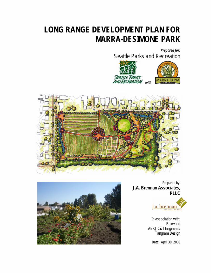
LONG RANGE DEVELOPMENT PLAN FOR MARRA-DESIMONE PARK Prepared for: Seattle Parks and Recreation with Prepared by: J.A. Brennan Associates, PLLC In association with: Boxwood ABKJ Civil Engineers Tangram Design Date: April 30, 2008
Transcript of LONG RANGE DEVELOPMENT PLAN FOR MARRA-DESIMONE PARK · j.a. brennan associates, PLLC - 1 -...
LONG RANGE DEVELOPMENT PLAN FOR MARRA-DESIMONE PARK
Prepared for:
Seattle Parks and Recreation
with
Prepared by: J.A. Brennan Associates,
PLLC
In association with:
Boxwood ABKJ Civil Engineers
Tangram Design
Date: April 30, 2008
Preface
j.a. brennan associates, PLLC - i - Marra-Desimone Park Long Range Development Plan
Preface to the Long Range Development Plan This report was originally prepared in 2007 to provide background and guidance for the long range development of Marra-Desimone Park. The draft plan, as shown in Figure 1, was presented to the Seattle Board of Park Commissioners (Parks Board) on October 26, 2006 and approved by the Parks Board on November 9, 2006. The plan was later revised in spring of 2007 at the request of the Marra Farm Coalition and with the approval of Seattle Parks Interim Superintendent B.J. Brooks. The revisions included reducing the width of the Sun Arc path and adjacent planting area through the farm and deletion of some auxiliary pathways. The Parks Board was advised of these revisions on May 10, 2007. The final plan revisions are shown in Figure 4. This 2008 version of the report documents the above noted revisions and stands as a record of the community project and a reference for further development stages. This report does not attempt to include site developments after May 2007. In summer 2007, Seattle Public Utilities (SPU) initiated design of a drainage relief project adjacent to and including Marra-Desimone Park. The SPU design is consistent with the final Long Range Development Plan and includes re-grading the east property of the park, installation of drainage swales, a parking lot, and a portion of the Sun Arc pathway. Implementation of the SPU project is expected to begin in the summer of 2008. It is important to note that the Parks Board approved the overall plan as shown in Figure 1, and briefing documents provided by Seattle Parks staff but it did not review and approve all details contained within this 2008 report. To ensure that current planning and development standards are met, Seattle Parks will need to review specific elements of the plan as they are implemented.

Marra-Desimone Park Long Range Development Plan - ii j.a. brennan associates, PLLC
Acknowledgements
j.a. brennan associates, PLLC - iii - Marra-Desimone Park Long Range Development Plan
Acknowledgements This report represents a collaborative process between the citizens of Seattle’s South Park community, the Marra Farm Coalition and Seattle Parks and Recreation staff. By taking the time to participate in public meetings, review documents, and share ideas, the following individuals assisted in insuring the success of this long range development plan. City of Seattle Parks and Recreation Department Cathy Tuttle David W. Goldberg Kevin Bergsrud Virginia Hassinger Marra Farm Coalition
Backyard Starts I’m a Pal Foundation (IMAPAL) and King County Conservation District Lettuce Link (Solid Ground) Master Composters/ Master Soil Builders South Park Area Redevelopment Committee (SPARC) South Park Community Gardeners P-patch, and City of Seattle Department of Neighborhoods Seattle Youth Garden Works University of Washington (UW)/King County Master Gardeners - Mien Community Garden
University of Washington Graduate Student Eric Higbee, MLA For his work on his Master Thesis: Seattle’s Last/ First Farm – Cultivating community, agriculture, and environment in our urban context Consultants J.A. Brennan Associates, PLLC Boxwood Andersen Bjornstad Kane Jacobs Tangram Design Douglass Consulting

Marra-Desimone Park Long Range Development Plan - iv j.a. brennan associates, PLLC
Table of Contents
j.a. brennan associates, PLLC - v - Marra-Desimone Park Long Range Development Plan
Table of Contents
Preface to the Long Range Development Plan...........................................................................................................i Acknowledgements ....................................................................................................................................................iii Table of Contents.........................................................................................................................................................v Introduction ..................................................................................................................................................................1
Purpose and Need for the Plan................................................................................................................................................. 1 Timeline of Recent Marra Farm History .................................................................................................................................. 1
Stakeholders............................................................................................................................................................................... 2 Marra Farm Coalition............................................................................................................................................................... 2
Public Involvement Process ..................................................................................................................................................... 2 Inventory and Analysis................................................................................................................................................4
Cultural Resources .................................................................................................................................................................... 4 History ..................................................................................................................................................................................... 4 Community Context / Adjacent Properties .............................................................................................................................. 4
Existing Structures .................................................................................................................................................................... 4 Access, Transportation, and Parking....................................................................................................................................... 5 Experience and Aesthetics ....................................................................................................................................................... 5 Natural Resources ..................................................................................................................................................................... 5
Soil / Geotechnical .................................................................................................................................................................. 5 Water Resources..................................................................................................................................................................... 5 Wetlands ................................................................................................................................................................................. 6
Vegetation................................................................................................................................................................................... 7 Wildlife ........................................................................................................................................................................................ 7 Utilities ........................................................................................................................................................................................ 7
Vision / Goals ...............................................................................................................................................................8 Vision Statement........................................................................................................................................................................ 8 Project Goals.............................................................................................................................................................................. 8 Agricultural Goals ...................................................................................................................................................................... 8 Community Integration Goals................................................................................................................................................... 8 Environmental Stewardship Goals........................................................................................................................................... 8 Aesthetic Goals .......................................................................................................................................................................... 8 Passive and Active Recreation Goals...................................................................................................................................... 8 Cultural Resource Goals ........................................................................................................................................................... 9 Revenue Enhancement Goals................................................................................................................................................... 9 Program Opportunities.............................................................................................................................................................. 9
Program Element .................................................................................................................................................................... 9
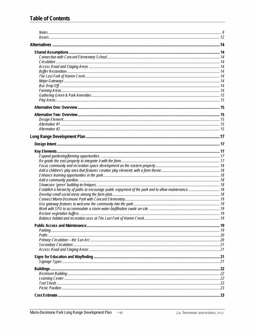
Table of Contents
Marra-Desimone Park Long Range Development Plan - vi j.a. brennan associates, PLLC
Notes....................................................................................................................................................................................... 9 Issues.................................................................................................................................................................................... 12
Alternatives ................................................................................................................................................................14 Shared Assumptions ............................................................................................................................................................... 14
Connection with Concord Elementary School ....................................................................................................................... 14 Circulation ............................................................................................................................................................................. 14 Access Road and Staging Areas .......................................................................................................................................... 14 Buffer Restoration ................................................................................................................................................................. 14 The Lost Fork of Hamm Creek.............................................................................................................................................. 14 Major Gateways .................................................................................................................................................................... 14 Bus Drop Off ......................................................................................................................................................................... 14 Farming Areas....................................................................................................................................................................... 14 Gathering Green & Park Amenities....................................................................................................................................... 15 Play Areas: ............................................................................................................................................................................ 15
Alternative One: Overview ...................................................................................................................................................... 15 Alternative Two: Overview ...................................................................................................................................................... 15
Design Element ..................................................................................................................................................................... 15 Alternative #1 ........................................................................................................................................................................ 15 Alternative #2 ........................................................................................................................................................................ 15
Long Range Development Plan ................................................................................................................................17 Design Intent ............................................................................................................................................................................ 17 Key Elements............................................................................................................................................................................ 17
Expand gardening/farming opportunities. ............................................................................................................................. 17 Re-grade the east property to integrate it with the farm........................................................................................................ 17 Focus community and recreation space development on the eastern property.................................................................... 18 Add a children’s play area that features creative play elements with a farm theme.............................................................. 18 Enhance learning opportunities in the park. .......................................................................................................................... 18 Add a community pavilion. .................................................................................................................................................... 18 Showcase ‘green’ building techniques. ................................................................................................................................. 18 Establish a hierarchy of paths to encourage public enjoyment of the park and to allow maintenance. ................................ 18 Develop small social areas among the farm plots................................................................................................................. 18 Connect Marra-Desimone Park with Concord Elementary.................................................................................................... 19 Use gateway features to welcome the community into the park. .......................................................................................... 19 Work with SPU to accommodate a storm water biofiltration swale on-site. .......................................................................... 19 Restore vegetative buffers. ................................................................................................................................................... 19 Balance habitat and recreation uses at The Lost Fork of Hamm Creek................................................................................ 19
Public Access and Maintenance............................................................................................................................................. 19 Parking .................................................................................................................................................................................. 19 Paths ..................................................................................................................................................................................... 20 Primary Circulation – the Sun Arc: ........................................................................................................................................ 20 Secondary Circulation: .......................................................................................................................................................... 21 Access Road and Staging Areas: ......................................................................................................................................... 21
Signs for Education and Wayfinding ..................................................................................................................................... 21 Signage Types ...................................................................................................................................................................... 21
Buildings................................................................................................................................................................................... 22 Restroom Building................................................................................................................................................................. 22 Learning Center .................................................................................................................................................................... 22 Tool Sheds ............................................................................................................................................................................ 23 Picnic Pavilion ....................................................................................................................................................................... 23
Cost Estimate ........................................................................................................................................................................... 23
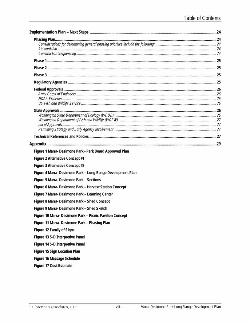
Table of Contents
j.a. brennan associates, PLLC - vii - Marra-Desimone Park Long Range Development Plan
Implementation Plan – Next Steps ...........................................................................................................................24 Phasing Plan............................................................................................................................................................................. 24
Considerations for determining general phasing priorities include the following:.................................................................. 24 Stewardship .......................................................................................................................................................................... 24 Construction Sequencing ...................................................................................................................................................... 24
Phase 1...................................................................................................................................................................................... 25 Phase 2...................................................................................................................................................................................... 25 Phase 3...................................................................................................................................................................................... 25 Regulatory Agencies ............................................................................................................................................................... 25 Federal Approvals.................................................................................................................................................................... 26
Army Corps of Engineers ...................................................................................................................................................... 26 NOAA Fisheries .................................................................................................................................................................... 26 US Fish and Wildlife Service ................................................................................................................................................. 26
State Approvals........................................................................................................................................................................ 26 Washington State Department of Ecology (WDOE).............................................................................................................. 26 Washington Department of Fish and Wildlife (WDFW) ......................................................................................................... 27 Local Approvals..................................................................................................................................................................... 27 Permitting Strategy and Early Agency Involvement .............................................................................................................. 27
Technical References and Policies ........................................................................................................................................ 27 Appendix.....................................................................................................................................................................29
Figure 1 Marra- Desimone Park - Park Board Approved Plan Figure 2 Alternative Concept #1 Figure 3 Alternative Concept #2 Figure 4 Marra- Desimone Park – Long Range Development Plan Figure 5 Marra- Desimone Park – Sections Figure 6 Marra- Desimone Park – Harvest Station Concept Figure 7 Marra- Desimone Park – Learning Center Figure 8 Marra- Desimone Park – Shed Concept Figure 9 Marra- Desimone Park – Shed Sketch Figure 10 Marra- Desimone Park – Picnic Pavilion Concept Figure 11 Marra- Desimone Park – Phasing Plan Figure 12 Family of Signs Figure 13 S-D Interpretive Panel Figure 14 S-D Interpretive Panel Figure 15 Sign Location Plan Figure 16 Message Schedule Figure 17 Cost Estimate

Introduction
j.a. brennan associates, PLLC - 1 - Marra-Desimone Park Long Range Development Plan
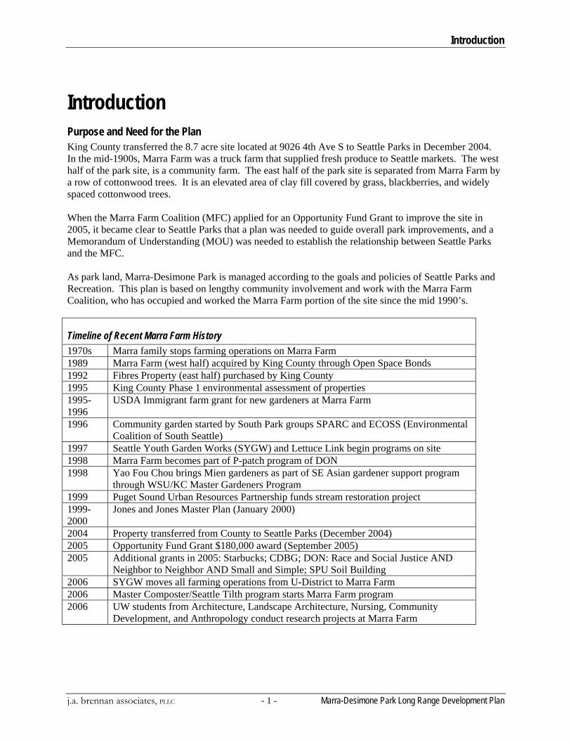
Introduction Purpose and Need for the Plan King County transferred the 8.7 acre site located at 9026 4th Ave S to Seattle Parks in December 2004. In the mid-1900s, Marra Farm was a truck farm that supplied fresh produce to Seattle markets. The west half of the park site, is a community farm. The east half of the park site is separated from Marra Farm by a row of cottonwood trees. It is an elevated area of clay fill covered by grass, blackberries, and widely spaced cottonwood trees. When the Marra Farm Coalition (MFC) applied for an Opportunity Fund Grant to improve the site in 2005, it became clear to Seattle Parks that a plan was needed to guide overall park improvements, and a Memorandum of Understanding (MOU) was needed to establish the relationship between Seattle Parks and the MFC. As park land, Marra-Desimone Park is managed according to the goals and policies of Seattle Parks and Recreation. This plan is based on lengthy community involvement and work with the Marra Farm Coalition, who has occupied and worked the Marra Farm portion of the site since the mid 1990’s.
Timeline of Recent Marra Farm History 1970s Marra family stops farming operations on Marra Farm 1989 Marra Farm (west half) acquired by King County through Open Space Bonds 1992 Fibres Property (east half) purchased by King County 1995 King County Phase 1 environmental assessment of properties 1995-1996
USDA Immigrant farm grant for new gardeners at Marra Farm
1996 Community garden started by South Park groups SPARC and ECOSS (Environmental Coalition of South Seattle)
1997 Seattle Youth Garden Works (SYGW) and Lettuce Link begin programs on site 1998 Marra Farm becomes part of P-patch program of DON 1998 Yao Fou Chou brings Mien gardeners as part of SE Asian gardener support program
through WSU/KC Master Gardeners Program 1999 Puget Sound Urban Resources Partnership funds stream restoration project 1999-2000
Jones and Jones Master Plan (January 2000)
2004 Property transferred from County to Seattle Parks (December 2004) 2005 Opportunity Fund Grant $180,000 award (September 2005) 2005 Additional grants in 2005: Starbucks; CDBG; DON: Race and Social Justice AND
Neighbor to Neighbor AND Small and Simple; SPU Soil Building 2006 SYGW moves all farming operations from U-District to Marra Farm 2006 Master Composter/Seattle Tilth program starts Marra Farm program 2006 UW students from Architecture, Landscape Architecture, Nursing, Community
Development, and Anthropology conduct research projects at Marra Farm
Introduction
Marra-Desimone Park Long Range Development Plan - 2 j.a. brennan associates, PLLC
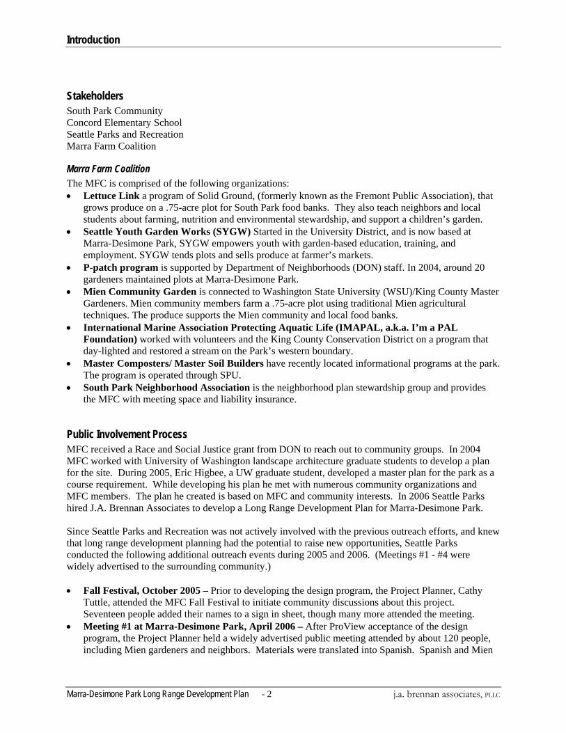
Stakeholders South Park Community Concord Elementary School Seattle Parks and Recreation Marra Farm Coalition
Marra Farm Coalition The MFC is comprised of the following organizations: • Lettuce Link a program of Solid Ground, (formerly known as the Fremont Public Association), that
grows produce on a .75-acre plot for South Park food banks. They also teach neighbors and local students about farming, nutrition and environmental stewardship, and support a children’s garden.
• Seattle Youth Garden Works (SYGW) Started in the University District, and is now based at Marra-Desimone Park, SYGW empowers youth with garden-based education, training, and employment. SYGW tends plots and sells produce at farmer’s markets.
• P-patch program is supported by Department of Neighborhoods (DON) staff. In 2004, around 20 gardeners maintained plots at Marra-Desimone Park.
• Mien Community Garden is connected to Washington State University (WSU)/King County Master Gardeners. Mien community members farm a .75-acre plot using traditional Mien agricultural techniques. The produce supports the Mien community and local food banks.
• International Marine Association Protecting Aquatic Life (IMAPAL, a.k.a. I’m a PAL Foundation) worked with volunteers and the King County Conservation District on a program that day-lighted and restored a stream on the Park’s western boundary.
• Master Composters/ Master Soil Builders have recently located informational programs at the park. The program is operated through SPU.
• South Park Neighborhood Association is the neighborhood plan stewardship group and provides the MFC with meeting space and liability insurance.
Public Involvement Process MFC received a Race and Social Justice grant from DON to reach out to community groups. In 2004 MFC worked with University of Washington landscape architecture graduate students to develop a plan for the site. During 2005, Eric Higbee, a UW graduate student, developed a master plan for the park as a course requirement. While developing his plan he met with numerous community organizations and MFC members. The plan he created is based on MFC and community interests. In 2006 Seattle Parks hired J.A. Brennan Associates to develop a Long Range Development Plan for Marra-Desimone Park. Since Seattle Parks and Recreation was not actively involved with the previous outreach efforts, and knew that long range development planning had the potential to raise new opportunities, Seattle Parks conducted the following additional outreach events during 2005 and 2006. (Meetings #1 - #4 were widely advertised to the surrounding community.) • Fall Festival, October 2005 – Prior to developing the design program, the Project Planner, Cathy
Tuttle, attended the MFC Fall Festival to initiate community discussions about this project. Seventeen people added their names to a sign in sheet, though many more attended the meeting.
• Meeting #1 at Marra-Desimone Park, April 2006 – After ProView acceptance of the design program, the Project Planner held a widely advertised public meeting attended by about 120 people, including Mien gardeners and neighbors. Materials were translated into Spanish. Spanish and Mien
Introduction
j.a. brennan associates, PLLC - 3 - Marra-Desimone Park Long Range Development Plan
interpreters were present. The comments from this meeting confirmed the direction of the design program.
• Concord Elementary, May 2006 – Seattle Parks staff met with a 3rd grade class to survey the students' interests in the park.
• Meeting #2 South Park Community Center, June 2006 – About 25 people attended this meeting to discuss elements of the long range plan.
• Meeting # 3 Summer BBQ at Marra-Desimone Park, August 2006 – Seattle Parks advertised community-wide that staff and consultants would be presenting and discussing the draft plan at the BBQ. About 75 people attended the BBQ. Spanish and Mien translation was available. Attendees responded favorably to the project direction.
• Meeting # 4 Fall Festival, October 2006 – Seattle Parks advertised community-wide that staff would be present to discuss the plan at this festival attended by 75 – 100 community members and gardeners. The plan was favorably received.
Inventory and Analysis
Marra-Desimone Park Long Range Development Plan - 4 j.a. brennan associates, PLLC
Inventory and Analysis Cultural Resources
History Marra-Desimone Park is one of the last remnants of agricultural land in Seattle. Founded by Italian immigrant, Carmine Marra, Marra Farm was operated by his family for approximately 60 years. The land surrounding Marra Farm, including the east side of the property, was owned by Joe Desimone, an Italian farmer who eventually acquired and ran the Pike Place Market in the 1940s. Marra Farm produce, including corn, lettuce, cabbage, beets, bunching onions, beans, peas, radishes, carrots, cucumbers and zucchini, was sold in Pike Place market or delivered to small groceries around the city. The Marra family stopped farming the site around 1980, and soon after it was purchased by King County with open space funds. The west portion of Marra-Desimone Park is currently managed by the MFC. In 2005, Marra Farm and the adjacent east property, which together make up Marra-Desimone Park, were acquired by Seattle Parks and Recreation and soon afterward MFC was awarded an $180,000 Pro Parks Levy Opportunity Fund Grant.
Community Context / Adjacent Properties Marra-Desimone Park is located in the lower Duwamish River Valley, historically an alluvial floodplain of the Duwamish River before the river was channelized in the early 20th century for use as an industrial waterway. Marra-Desimone Park is located in the South Park neighborhood, an ethnically diverse residential area with a population of 3,700. South Park has the highest concentration of Latinos/Hispanics in Seattle, 37% of the population. The neighborhood is also 14% Asian and 34% immigrant. South Park has an above average level of poverty (12.5% of South Park residents live at or below the poverty line) and higher levels of non-English speakers, single mothers, and residents without a high school degree, than Seattle as a whole. However, South Park is changing rapidly as more affluent residents are attracted to the area by its affordable housing prices. The result is a highly diverse and unique neighborhood with a growing need for both community gardens and recreational open space. Marra-Desimone Park is located in the southwest corner of South Park. One half mile north, the South Park Community Center provides sports fields and basketball courts, and runs a variety of youth and community programs. Near the Community Center, Cesar Chavez Park opened in March 2008, and a skate park is in the planning phase. One block from Marra-Desimone Park, Concord Elementary School has basketball courts and a small field. East of Concord Elementary a footbridge provides access over SR 99 to the SeaMar Community Care Center, a residential home for Latino seniors. A series of wetlands located two blocks north of the park are managed by Habitat for Humanity and the Northwest Native Plant Society. A large recycling plant abuts the south boundary of the Park. The other three sides face a residential neighborhood of mostly single-family houses; many of the adjacent streets lack sidewalks.
Existing Structures The park has several tool sheds and makeshift shelters. Three tool sheds are located near the center of the park, adjacent to the P-Patch. Two more sheds, including a community classroom constructed by University of Washington architecture students, are located on the northwest corner of the park. Miscellaneous benches and picnic tables are also placed throughout the property. Three information kiosks, a set of interpretive signs, and hand painted signs made by MFC members are placed around the
Inventory and Analysis
j.a. brennan associates, PLLC - 5 - Marra-Desimone Park Long Range Development Plan
cultivated portion of the park. A portable toilet, serviced by Seattle Parks, is located just south of the parking area on South Director Street. A six-foot high wooden fence defines the 340’ northern boundary between the park and a single-family lot. The historic farm shed and barn have been torn down, but the Marra farmhouse, located adjacent to the park on 4th Ave, still stands.
Access, Transportation, and Parking Access to the park is restricted by a berm on the south edge, a high fence along the western portion of north edge, and by the overgrown slopes of the east property. The two primary entrances to Marra-Desimone Park are at the parking lots at the northwest and north central part of the park. There is also restricted vehicular access on the southwest corner of the park, and small informal footpaths enter at the eastern and northern edges of the east property. A wood-chipped path runs around the perimeter of the park. Paths through the gardens are poorly connected and unclear, with fences interrupting some routes. The primary gathering area is an open grassy area near a stand of cottonwood trees in the middle of the park. People also gather in the northwest corner, at the base for one of the MFC organizations.
Experience and Aesthetics The user experience of Marra-Desimone Park is dominated by its agricultural feel. The farm portion of the park has few trees, with long views across cultivated rows and fenced plots. The plateau, or east property, of the park is overgrown and difficult to access, making it seem a much less important part of the space than the farm. The smell of earth and the sounds of birds contrast with traffic and recycling plant noises. While sometimes the park is bustling with people, at other times, especially at night, the park is lonely and feels unsafe. Many Marra-Desimone Park users have expressed fear at being there in the evening and have reported that local gangs often occupy the space at night. Marra-Desimone Park has inconsistent signage and poor visual organization. To people entering the park, it is unclear who owns the property, where they should go, and what the permitted uses are. Since Marra-Desimone Park is managed by several small organizations, the park appears to be a hodgepodge of public and private elements.
Natural Resources
Soil / Geotechnical Marra-Desimone Park is located among the alluvial deposits of the Duwamish River basin and its tributaries. The low point on the site is at the northwest edge, where a remnant of the stream that once flowed through the park is located. The soils on the farm portion of the park are original agricultural soils – rich, loamy and productive. The eastern portion of the park is ten to fifteen feet higher than the rest of the park and is composed of fill removed from the 1964 construction site of nearby State Route 509. This fill consists of poorly draining clay-based sub-soils that are not useful for agriculture. Excavation pits and soil testing conducted in 1999 by the King County Office of Open Space showed no significant levels of heavy metals or other contaminants. A large twenty-foot high berm along the south side of the property, owned by Fibres International, was constructed there to serve as a noise buffer between the recycling plant and residential areas north of the park.
Water Resources The Lost Fork of Hamm Creek flows for most of the year along the western edge of the park. A storm drain pipe was daylighted in 2000 and the Lost Fork of Hamm Creek was restored by a community coalition led by John Beal and I’m A Pal. It is not connected to Hamm Creek, and outflow drains into a
Inventory and Analysis
Marra-Desimone Park Long Range Development Plan - 6 j.a. brennan associates, PLLC
storm-water pipe. On the rest of the parkland rainfall is readily absorbed by the park’s rich organic soils and generates little runoff. The park’s low point tends to be wetter than the rest of the park and was historically used to grow water-loving vegetables such as celery. Juvenile salmon were planted previously by the community in the Lost Fork of Hamm creek. Further research would be needed to verify if the creek is considered a fish bearing creek. Any development near the Lost Fork of Hamm Creek will be influenced by a buffer requirement per the Seattle Land Use Code. The riparian buffer for the Lost Fork of Hamm Creek is 100 feet from the top of bank or Ordinary High Water Mark (OHWM), depending on the configuration of the creek channel. Seattle Municipal Code section 25.09.200 outlines allowable activities within riparian buffers. Existing public or private streets are excluded from the regulations for riparian management areas providing that the provisions of Title 22, Substitute VIII (Stormwater, Grading, and Drainage Control Code) apply. Development within the riparian buffer is prohibited except to provide access to development and as follows:
a. For creeks without salmonids, the inner 50 feet of the buffer is a No Build Zone, and the outer 50 feet is a riparian management area, with limited activities allowed.
b. For creeks with salmonids, the inner 75 feet of the buffer is a No Build Zone and the outer 25 feet is a riparian management area.
Rain that falls on the clay subsoils of the east property does not readily infiltrate, and large pools appear during the winter months. A ditch along the base of the berm on the south side of the east property drains water into another ditch along the east side. In the winter this ditch, which also collects water from adjacent properties, often overflows and partially floods South Director Street. Seattle Public Utilities is currently constructing a series of bio-swales in the east portion of the park to collect and infiltrate this water.
Wetlands A small seasonally saturated wetland, less than 1,000 square feet in size, was identified on the east portion of the park, immediately east of the berm and black cottonwoods. The wetland has a perched seasonal water table and was likely formed due to perched compacted clay fill soils. This wetland appears to be isolated from any other surface water; however, any classification of ‘isolated’ must be confirmed by the US Army Corps of Engineers (USACE). Vegetation within the wetland is dominated by grass and emergent species including softrush (Juncus effuses), and creeping buttercup (Ranunculus repens) with an overstory of black cottonwood (Populus balsamifera), and willow (Salix sp.). Per the Seattle Municipal Code (SMC 25.09.160) and Department of Planning and Development (DPD) the wetland identified in the east property is classified as a Category IV wetland. Development may occur within or over Category IV wetlands less than one thousand (1,000) square feet in area, other than those wetlands described in subsection B1c (riparian wetlands), in accordance with subsection C3. The on-site wetland is not associated with the Lost Fork of Hamm Creek, and is not considered a riparian wetland. Any wetland fills of non-isolated wetlands would require a USACE permit, with fills under 0.5 acres in size generally falling under the Nationwide Permit (NWP) program. If the wetland is found to be isolated, the USACE would not require a NWP. However, the Washington Department of Ecology (WDOE) would likely require an administrative permit to fill any isolated wetlands.
Inventory and Analysis
j.a. brennan associates, PLLC - 7 - Marra-Desimone Park Long Range Development Plan
Vegetation The flat agricultural areas of Marra-Desimone Park are dominated by cultivated fruits and vegetables, while vegetation on the slopes, eastern property, and edges of the park are primarily pioneering native and invasive species. Ninety percent of the trees along these slopes are Black Cottonwood (Populus trichocarpus). There are also a few scattered Big Leaf Maples (Acer macrophyllus), European Hawthorn (Crataegus monogyna), a small area of Paper Birch (Betula papyrifera), and a lone Pacific Madrone (Arbutus menziesii). A group of mature Cottonwoods provides shade near the center of the park. A broken line of Black Poplars (Populus nigra) runs along the old park road. Multiple fruit trees are dispersed throughout the park including juvenile and varied orchard species near the park center. Restored areas at The Lost Fork of Hamm Creek and near the parking lot are planted with native trees including Western Red Cedar (Thuja plicata), Douglas Fir (Pseudostuga menzeisii), and Beaked Hazelnut (Corylus cornuta). Restoration areas also contain a mix of native understory plants such as Twinberry (Lonicera involucrata), Red-twig Dogwood (Cornus sericea), and Nootka Rose (Rosa nutkana). The majority of the berm is covered in Himalayan Blackberry (Rubus discolor). Blackberries once covered a larger portion of the park but have been significantly cleared in the past several years. However, the east property, currently a mix of shrubs and grasses, is quickly being overtaken by blackberries. Seattle Parks has conducted a tree survey of the property. Several of the existing fast-growing trees, including a small grove of massive cottonwoods perceived as “significant gathering trees” by the community, are recommended by Parks for removal due to safety concerns.
Wildlife Marra-Desimone Park’s proximity to the Duwamish River and the West Duwamish Greenbelt make it an attractive site for local and migratory birds. Birds of prey such as osprey and red-tailed hawks are often sighted at the park. Water loving birds including herons and ducks are often seen in the creek. Numerous other birds, including hummingbirds and redwing blackbirds are seen throughout the year. The park is home to a variety of other small animals including rabbits, moles and mice. Coyotes have been reported a few blocks south of the park, which is consistent with studies that have identified the West Duwamish Greenbelt as a coyote habitat area and movement corridor (Quinn, 1995).
Utilities Water and sanitary sewer is available in Director Street for future implementation of a restroom and educational center. The MFC recently installed an irrigation system that connects to the single water source entering the property at South Director Street.
Vision / Goals
Marra-Desimone Park Long Range Development Plan - 8 j.a. brennan associates, PLLC
Vision / Goals Vision Statement The vision for the park is to create an engaging and welcoming urban park that provides open space and educational benefits to the South Park community, meets the operational needs of the Marra Farm Coalition’s programs, and offers an agriculturally-based educational resource/model for the city of Seattle.
Project Goals • Develop a long-term plan that guides future growth and programming. • Assist in the development of a Memorandum of Agreement between the City and the MFC that
supports the Marra-Desimone Park long-term development plan. • Install and/or construct improvements consistent with the scope of the long-range plan. These
may include paths, park furnishings, and improved parking areas.
Agricultural Goals • Develop facilities that support the MFC’s agricultural and educational programs. • Maintain or increase the amount of available agricultural land
Community Integration Goals • Strengthen visual and pedestrian accessibility to the surrounding neighborhood. • Strengthen the connection with Concord Elementary School. • Provide recreational and open space amenities that are integrated and balanced with farming
areas. • Provide opportunities for cultural and community expression
Environmental Stewardship Goals • Restore and enhance native habitat areas. • Demonstrate sustainable building and agricultural practices.
Aesthetic Goals • Convey a strong sense of agricultural identity. • Maintain a rustic, natural, and recycled aesthetic. • Highlight the site’s seasonal changes and natural processes.
Passive and Active Recreation Goals • Provide opportunities for passive recreation. Include walking paths • Provide open space for informal sports • Provide play areas for children.
Vision / Goals
j.a. brennan associates, PLLC - 9 - Marra-Desimone Park Long Range Development Plan
Cultural Resource Goals • Honor and reveal the park’s rich agricultural heritage.
Revenue Enhancement Goals • Find research grant opportunities.
Program Opportunities The Long Range Development Plan primarily addresses the physical improvements to the site. Programmatic objectives are described because they are the foundation for the physical improvements. The implementation of programmatic goals remains flexible since they will be refined and implemented over time largely by the MFC. The following program list was generated from public meetings during the long range development plan process and through Eric Higbee’s University of Washington master plan thesis project. It should be noted not all of the elements listed, are included the final long range development plan.
Program Element Notes
1. Community Open Space/Recreation Amenities Picnic Tables, Benches, and BBQ’s
Install 8 picnic tables, 15 benches, 2 BBQs, and 6 trash receptacles. Seattle Parks will purchase furnishings that meet Park Standards. Please note the MFC has requested park furnishings be anchored to the ground but not placed on concrete pads within the sections of the park maintained by the MFC. Because Open Space Bond funds limit the amount of impervious surface, Parks should consider this request.
Children’s Play Area Define an area for children’s play and exploration that is visible to volunteers working at the park. Plant vegetation that defines this children’s area, possibly an edible browsing garden. MFC and Community members have requested a farm-themed and dirt-oriented play area for children with little or no prefabricated plastic play equipment.
Gathering Green (Informal Sports Area)
Provide an open grassy area for informal sports and community events. Open Space Bond funds were used to keep this property as farmland so no scheduled athletic fields can be constructed. Consider a basketball half court.
Gathering Pavilion (see 7. Park Structures) 2. Farming and Community Garden Spaces Central Community Space
Provide a central node within the park enables the farm program of the park to integrate with the public space of the overall park.
Compost areas Define and locate a decentralized system of composting areas. Farming Areas Maintain or increase the amount of available agricultural land. Greenhouse (see 7. Park structures) Farm Animals Consider small animal management areas – bees, goats, chickens. Children’s Garden (see 2. Education) Supplemental Gardens (see 5. Vegetation) Orchard Increase/improve fruit trees/orchard area
Vision / Goals
Marra-Desimone Park Long Range Development Plan - 10 j.a. brennan associates, PLLC
3. Youth and Adult Education Define and locate children’s garden. Provide gathering spaces for classes and demonstrations.
A system of outdoor classrooms/ learning stations linked with farm operations and ecological restoration areas.
Strengthen the relationship with Concord Elementary School.
(See 6. Circulation)
Coordinate with summer and after-school programs at South Park Community Center.
Support private and public organizations on site that teach sustainable urban agriculture, environmental stewardship, and nutrition.
Interpretive Signage (See 6. Circulation)
4. Community Open Space/Recreation Amenities Picnic Tables, Benches, and BBQ’s
Install 8 picnic tables, 15 benches, 2 BBQs, and 6 trash receptacles. Seattle Parks will purchase furnishings that meet Park Standards. Please note the MFC has requested park furnishings be anchored to the ground but not placed on concrete pads within the sections of the park maintained by the MFC. Because Open Space Bond funds limit the amount of impervious surface, Parks should consider this request.
Children’s Play Area Define an area for children’s play and exploration that is visible to volunteers working at the park. Plant vegetation that defines this children’s area, possibly an edible browsing garden. MFC and Community members have requested a farm-themed and dirt-oriented play area for children with little or no prefabricated plastic play equipment.
Informal Sports Area Provide an open grassy area for informal sports and events. Open Space Bond funds were used to keep this property as farmland so no scheduled athletic fields can be constructed. Consider a basketball half court.
Gathering Pavilion (see 7. Park Structures) 5. Vegetation and Native/Habitat areas. Gathering Trees Identify tree species and strategies for replacing gathering trees in the center of
the park. Other site trees Tree relocation and replacement should occur per the recommendations of the
Seattle Parks & Recreation tree report. Remove and replace hazard trees. After consultation with the community, some trees that have been recently planted may be relocated to areas where they can reach mature growth without shading farming areas.
Vegetation Plan Work with Seattle Parks staff and the community to define areas of farm, hedge and windbreak trees, native planting, farm ornamentals, and lawn. Create a vegetation plan that locates these areas. Some garden areas should have raised beds with ADA access. New vegetation may be placed to define park boundaries. Relocate Red-twig Dogwood and Cedar trees so that they do not shade farming areas. Replant Cedar trees at least 15’ on center so that they can reach mature growth. Remove the double-stemmed Cottonwood trees in active community areas. Plant an alternative community gathering tree, possibly swamp oak. Plant a row of low growing trees such as Shore Pine along the south border next to the
Vision / Goals
j.a. brennan associates, PLLC - 11 - Marra-Desimone Park Long Range Development Plan
berm to define the property boundary. Plant trees that provide shade while allowing maximum sunlight for produce gardens
Control Invasives Define invasive plants and their control. Native Restoration Create a buffer and bio-swales around the Lost Fork of Hamm Creek. Expand
native plant restoration areas around the creek and on slopes. Supplemental/ Demonstration/ Forage Gardens
Showcase sustainable agriculture techniques in demonstration gardens. Plant supplemental gardens such as hummingbird, butterfly, basketry, or medicinal gardens, and foraging areas for berries and fruits, particularly at the edges of children’s gardens and play areas.
Water quality Use a rainwater garden and cisterns to demonstrate water harvesting and recycling.
6.Pedestrian Circulation and Wayfinding Welcome Signage After the park is officially named, install one Seattle Parks standard rainbow sign
or a unique sign in the park. Other at-grade park entry points may have different bilingual signs.
Vehicular Directional Signage
Provide vehicular directional signage to the park site on Cloverdale Street.
Universal Access Path. A gravel path that allows Universal access through Marra-Desimone Park will be located in consultation with Parks staff and the community. Locate raised beds with ADA access along this accessible path.
Interpretive Signage Conform to Seattle Parks standards for interpretive signs. Honor community history with interpretive paths and signs. Determine whether existing information kiosks and interpretive signs meet Park Standards.
Paths Define a hierarchy of parking, vehicle access, bicycle, and pedestrian pathways within the garden and around the perimeter. Provide benches for rest and places to view the farm.
Sidewalks Seattle Public Utilities in conjunction with Seattle Parks are implementing a drainage swale in the NE corner of the site to alleviate flooding on Director St. and provide water quality improvements.
Gateways Clearly define entrances and gateways to the park. Bilingual signs should identify the park as common public land.
Concord Connection Work with Concord Elementary, SDOT and SPU to provide a safe connection for schoolchildren to walk from school to the park.
Improve internal circulation
Define community walking/biking paths and post areas that are off-limits to dogs and off-road vehicles. Define formal/informal park areas.
Creek Enhance the creek restoration project and create viewing areas into The Lost Fork of Hamm Creek to provide creek habitat education opportunities. Due to extensive permit constraints, as well as cost and maintenance concerns, a bridge over the creek is an unfeasible option at this time. Identify a location for children to interact with the creek.
7. Park structures and improved infrastructure Vehicular circulation and staging areas
Define and grade areas for park and farm vehicle access, and staging areas for hauling materials to and from the site. The access road should be controlled by a fence or bollards, graded to Seattle Parks Standards, and surfaced with pervious materials, possibly compacted crushed rock or grass-crete.
Toilet A composting toilet was considered, but determined to be infeasible due to permitting constraints. Identify a location for a traditional restroom facility.
Parking lot Identify an on-site area for visitor parking. This parking will be graded to Parks
Vision / Goals
Marra-Desimone Park Long Range Development Plan - 12 j.a. brennan associates, PLLC
Standards and could be surfaced with pervious materials such as grass-crete. . Buffer parking areas. Arrange special event parking with Concord Elementary School.
Structures (General) Build sustainable structures which include minimal site disturbance, rainwater collection, solar energy, and natural ventilation and/or day-lighting. Limit impervious surfacing to 15% of the site, maximum.
Learning Center Seattle Parks proposes, as a long-term goal, enhancing the role of Marra Desimone Park as an Urban Agricultural Learning Center with a Learning Center building. A Learning Center building could support outreach staff, educational programs, an indoor classroom/meeting area, a community kitchen, and internet access for research. This building could be modeled on the Seward Park Environmental Learning Center and have cooperative programming. The kitchen could offer nutrition classes, cooking demonstrations featuring in-season farm-fresh produce, and be available to local farmers for value-added processing. A caretaker residence could possibly be incorporated into the Learning Center building, as could possible farm stands (see 8. Employment).
Tool Shed Locate and define construction standards for storage/tool sheds which meet Parks Standards. (Note: the Lettuce Link tool shed was constructed in 2005 to Parks Standards with arsenic-free treated lumber, and with a 2’ x 8’ modular structure that minimized cutting and waste. The shed supports “living walls” of peas, and rainwater runoff collection. This structure was intended to inform the standard of future construction at the park.)
Gathering Pavilion Locate an area for future construction of a large open-air pavilion, possibly including a large BBQ or oven
Greenhouse Locate an area for a greenhouse Cooking Facilities Consider cooking facilities to share food preparation skills from multiple
cultures. Consider alternative cooking sources such as solar cookers, cob stoves, or pizza ovens as in Dufferin Park in Toronto. Identify the best location for these cooking facilities.
8.Park Aesthetics and Cultural Diversity Create a landscape that is safe, accessible, productive, and easy for Parks staff to maintain. Create a unified park identity. Highlight the site’s seasonal changes and natural processes. Organize a hierarchy of farmed and public access spaces. Honor community and farm history on site. Maintain the site’s rustic, natural, recycled aesthetic when possible. Incorporate art when possible. Identify opportunities for community design/construction of farm elements. Celebrate the rich cultural diversity of the neighborhood with varied gardens, cooking areas, signs, and building types. Work with RCO on a Farmland Preservation Grant.
Issues Memorandum of Understanding (MOU) - Seattle Parks staff and the MFC will develop an MOU to delineate maintenance and management responsibilities, and expectations about community involvement and outreach. Successful implementation of the plan depends on creating this agreement. The agreement is still not negotiated at this time (spring 2008).
Vision / Goals
j.a. brennan associates, PLLC - 13 - Marra-Desimone Park Long Range Development Plan
Trees – The majority of the trees on site are short-lived Cottonwoods. As these trees mature they are prone to breakage. The mature cottonwoods in the center of the site are particularly liked due to the character and shade they provide. The plan elements will require cutting down many of the existing trees. New shade trees should be planted as soon as feasible to provide suitable replacement shade trees.
Alternatives
Marra-Desimone Park Long Range Development Plan - 14 j.a. brennan associates, PLLC
Alternatives Shared Assumptions Both alternative plans included the shared assumptions listed below.
Connection with Concord Elementary School Both alternatives emphasize a strong connection between Marra-Desimone Park and Concord Elementary School. Proposed street improvements along 6th Ave between Henderson Street and Director Street use natural drainage strategies to create a safe pedestrian environment for children and an exploratory and educational landscape. A new “Children’s Gateway” on the northeast corner of the park creates a close and accessible entrance.
Circulation Both alternatives use the Sun Arc developed in Eric Higbee’s thesis to provide a main circulation spine through the park. This path begins at the at the northeast entry corner of the park and travels through the center of the park to the west edge. Other circulation includes a loop trail and small paths through the agricultural areas.
Access Road and Staging Areas Both alternatives propose an access road on the existing historical road grade at the southern edge of the property. This moves the current access road south and opens space for more agricultural expansion. Staging areas for compost and material drop-off are located along its length. This road has a minimal footprint, perhaps two gravel tracks, which maintains the park’s rustic and rural feel. The road also serves as a walking path.
Buffer Restoration Native plant restoration will occur at the buffer along the property’s eastern edge.
The Lost Fork of Hamm Creek As The Lost Fork of Hamm Creek’s vegetation matures it will become a visual and accessibility barrier along the west edge of the property. Plants will be managed to allow two to three locations for sight lines into the park.
Major Gateways Entrances into the park are located at the northwest corner, at the intersection of 5th Avenue and Director Street, on Director Street at the edge of the farm and east property area, and at the northeast corner of the park. Other entrances include the maintenance access entrance in the southwest corner, and an informal foot path entrance in the southeast corner.
Bus Drop Off School bus drop off occurs on the western edge of the site.
Farming Areas Agricultural areas are maximized where possible, but specific programmatic uses are not defined because the allocation of space within agricultural areas is determined by the MFC.
Alternatives
j.a. brennan associates, PLLC - 15 - Marra-Desimone Park Long Range Development Plan
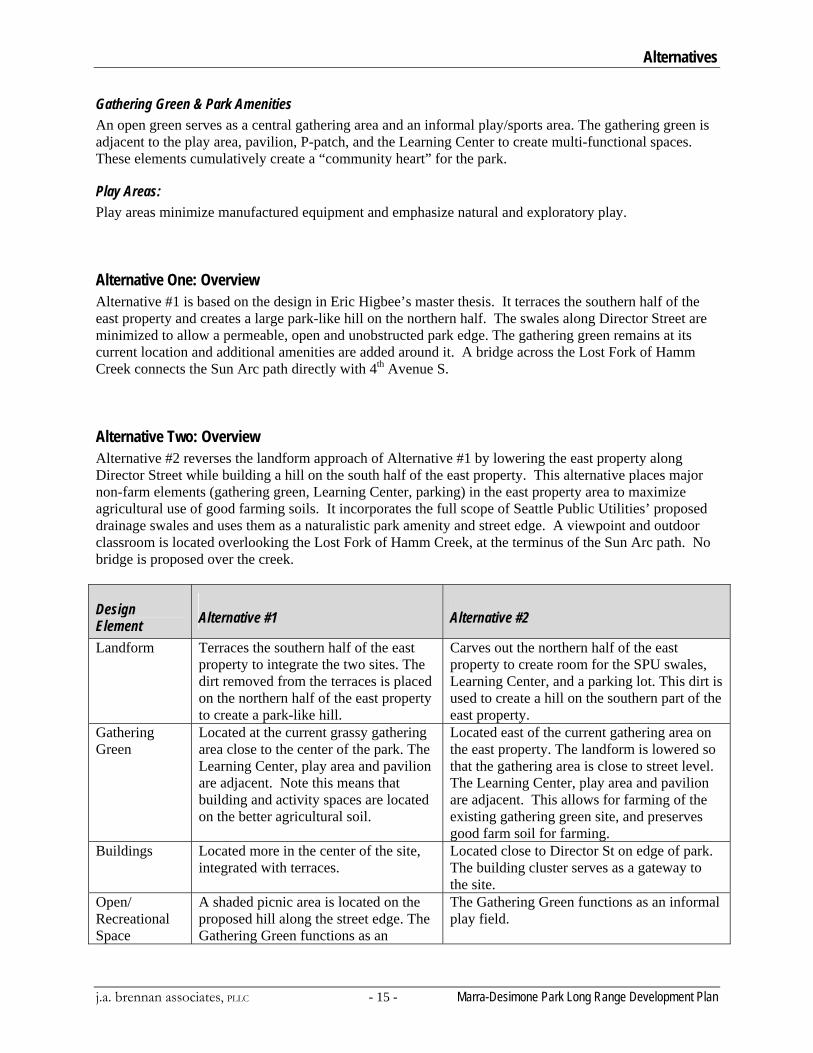
Gathering Green & Park Amenities An open green serves as a central gathering area and an informal play/sports area. The gathering green is adjacent to the play area, pavilion, P-patch, and the Learning Center to create multi-functional spaces. These elements cumulatively create a “community heart” for the park.
Play Areas: Play areas minimize manufactured equipment and emphasize natural and exploratory play.
Alternative One: Overview Alternative #1 is based on the design in Eric Higbee’s master thesis. It terraces the southern half of the east property and creates a large park-like hill on the northern half. The swales along Director Street are minimized to allow a permeable, open and unobstructed park edge. The gathering green remains at its current location and additional amenities are added around it. A bridge across the Lost Fork of Hamm Creek connects the Sun Arc path directly with 4th Avenue S.
Alternative Two: Overview Alternative #2 reverses the landform approach of Alternative #1 by lowering the east property along Director Street while building a hill on the south half of the east property. This alternative places major non-farm elements (gathering green, Learning Center, parking) in the east property area to maximize agricultural use of good farming soils. It incorporates the full scope of Seattle Public Utilities’ proposed drainage swales and uses them as a naturalistic park amenity and street edge. A viewpoint and outdoor classroom is located overlooking the Lost Fork of Hamm Creek, at the terminus of the Sun Arc path. No bridge is proposed over the creek.
Design Element Alternative #1 Alternative #2
Landform Terraces the southern half of the east property to integrate the two sites. The dirt removed from the terraces is placed on the northern half of the east property to create a park-like hill.
Carves out the northern half of the east property to create room for the SPU swales, Learning Center, and a parking lot. This dirt is used to create a hill on the southern part of the east property.
Gathering Green
Located at the current grassy gathering area close to the center of the park. The Learning Center, play area and pavilion are adjacent. Note this means that building and activity spaces are located on the better agricultural soil.
Located east of the current gathering area on the east property. The landform is lowered so that the gathering area is close to street level. The Learning Center, play area and pavilion are adjacent. This allows for farming of the existing gathering green site, and preserves good farm soil for farming.
Buildings Located more in the center of the site, integrated with terraces.
Located close to Director St on edge of park. The building cluster serves as a gateway to the site.
Open/ Recreational Space
A shaded picnic area is located on the proposed hill along the street edge. The Gathering Green functions as an
The Gathering Green functions as an informal play field.
Alternatives
Marra-Desimone Park Long Range Development Plan - 16 j.a. brennan associates, PLLC
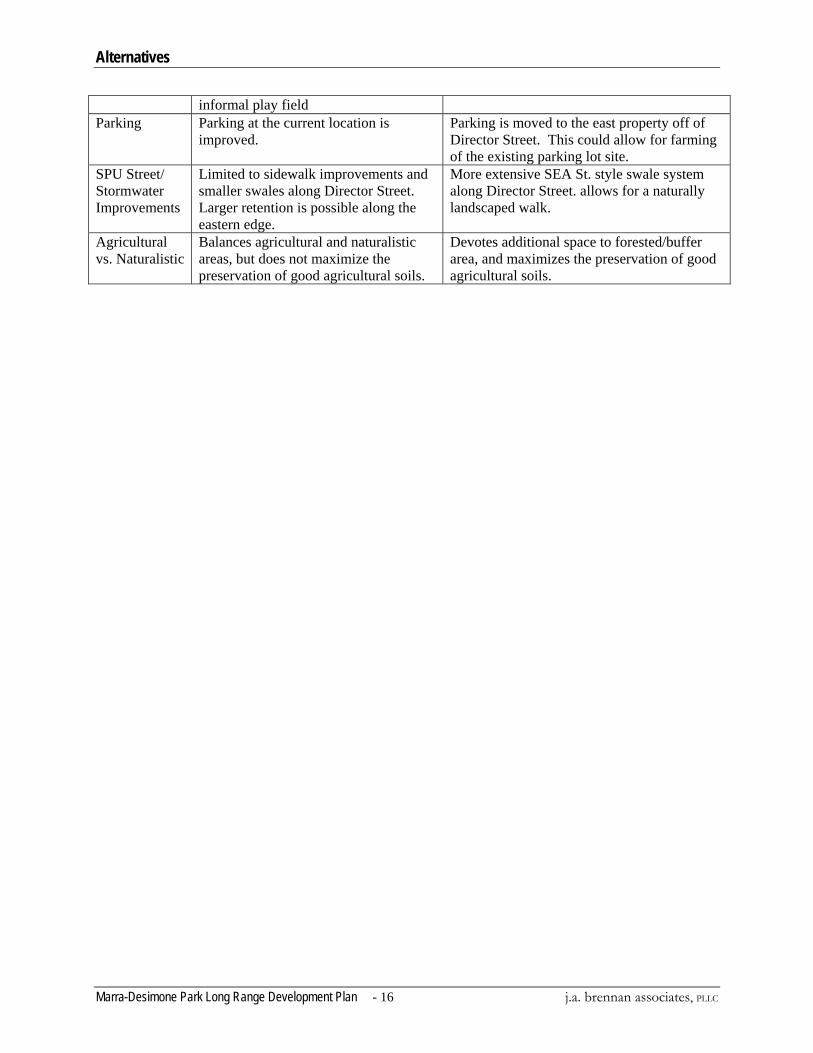
informal play field Parking Parking at the current location is
improved. Parking is moved to the east property off of Director Street. This could allow for farming of the existing parking lot site.
SPU Street/ Stormwater Improvements
Limited to sidewalk improvements and smaller swales along Director Street. Larger retention is possible along the eastern edge.
More extensive SEA St. style swale system along Director Street. allows for a naturally landscaped walk.
Agricultural vs. Naturalistic
Balances agricultural and naturalistic areas, but does not maximize the preservation of good agricultural soils.
Devotes additional space to forested/buffer area, and maximizes the preservation of good agricultural soils.
Long Range Development Plan
j.a. brennan associates, PLLC - 17 - Marra-Desimone Park Long Range Development Plan
Long Range Development Plan Design Intent
• Metaphor: ‘seed to build community’. Express the design concept of the park as a seed to build community.
• Seed: Two central nodes in the form of circles represent the seeds of the park. The focus of these spaces is community. One is composed of the Gathering Green, Educational Learning Center, Picnic Pavilion and Children’s Play area. The other is composed of the Harvest Station, a picnic area, and fruit trees available for picking to park visitors and community members. The overall design suggests a transition of the grid and patchwork patterns of agricultural land to patterns that are more organic and natural-looking.
• Sun: From the east visitors enter through a welcoming gateway walking on an arcing path that mimics the path of the sun. The path serves as the main circulation spine of the park, passing through the center of the park and linking the eastern edge to the western edge.
• Water: The design incorporates naturalistic swales that collect storm water and allow it to infiltrate. SPU’s functional water management system doubles as an attractive park amenity and street edge enhancement. A viewpoint and outdoor classroom is located beside the Lost Fork of Hamm Creek.
• Soil: Cut material from the swale is used to create a gently sloping meadow hill on the eastern edge of the park. Terraced agricultural gardens with flowing organic forms create a subtle transition from the naturalistic Meadow Hill to the rectilinear grid pattern of the farm area. Major non-farm elements (Gathering Green, Learning Center, parking, play area, farm buildings) are placed on the east property to maximize farm production on good agricultural soils.
• Care: Community involvement is encouraged through education programs, gardening opportunities, welcoming entries, and community activities within the park.
Key Elements Combining strategies from both alternatives, the Long Range Development Plan includes the following:
Expand gardening/farming opportunities. • Agricultural areas are maximized, and good agricultural soils are preserved. Specific
programmatic uses are not defined because the allocation of space within agricultural areas is determined by the MFC.
Re-grade the east property to integrate it with the farm. • The northern half of the east property has been lowered to facilitate the SPU swales, Learning
Center, and a parking lot. The cut material is used to create a hill on the southern part of the east property. Some material will need to be hauled off site.
• Grading for the drainage swales lowers the east property and opens the park up to Director Street, creating a sense of welcome to the site while improving site lines into the park for safety.
• Terracing on the southern half of the east property will integrate it with the west agricultural land. The cut material removed to create the terraces will be placed on the northern half of the east property to create a gently sloping Meadow Hill.
Long Range Development Plan
Marra-Desimone Park Long Range Development Plan - 18 j.a. brennan associates, PLLC
Focus community and recreation space development on the eastern property • Re-locating the parking lot and the gathering green to the east property, as well as locating new
building and recreation spaces here preserves good agricultural soils and opens more space for farming.
• The Gathering Green, the ‘seed to build community,’ is the primary community area and an informal play/sports area. The Gathering Green is adjacent to the play area, pavilion, bathroom, P-patch, and the Learning Center to create a multi-functional space. The combination of these elements forms the community heart of the park.
Add a children’s play area that features creative play elements with a farm theme. • The children’s play area is located near the Learning Center, and is visible from the P-Patch and
the Gathering Green. • The play area minimizes manufactured equipment and emphasizes natural and exploratory play.
The play area incorporates playful landforms and modified farm equipment.
Enhance learning opportunities in the park. • A potential Learning Center is located among the recreational/cultural activities clustered on the
Gathering Green. • Interpretive signage throughout the park educates visitors about history, agriculture, and ecology.
Add a community pavilion. • A pavilion at the junction of the community activities on the Gathering Green and the agricultural
activities on the farm creates a focal point for bringing the community to the farm for classes and picnics. The pavilion will host the MFC’s annual Summer BBQs and Fall Festivals, and may have a community cooking oven.
Showcase ‘green’ building techniques. • Architectural elements integrate sustainable ideas into the design and character of the structure.
Establish a hierarchy of paths to encourage public enjoyment of the park and to allow maintenance. • The Sun Arc path connects the corner near Concord Elementary with the park, farm plots, and
The Lost Fork of Hamm Creek. In the east property area, it provides sufficient width for access of maintenance vehicles.
• A secondary path forms a loop around the perimeter of the park. Portions of the loop path provide access for bulk materials distribution and for cleaning the drainage swale. A portion of the loop path meanders through the naturalistic Meadow Hill on the east property.
• Smaller paths in the farm portion of the park provide access between farming plots. • Paths leading to park amenities (the Learning Center, pavilion, restroom, etc.) are ADA
accessible.
Develop small social areas among the farm plots. • Resting and picnic opportunities are integrated along the paths to encourage public participation
in farming activities. • Farm sheds and green house structures are grouped at a central node along the arc path to create
a setting that invites park visitors to participate in the farming activities
Long Range Development Plan
j.a. brennan associates, PLLC - 19 - Marra-Desimone Park Long Range Development Plan
Connect Marra-Desimone Park with Concord Elementary. • Street improvements along 6th Avenue between Henderson Street and Director Street use natural
drainage strategies to create a safe pedestrian environment for children and an exploratory and educational landscape. A new “Children’s Gateway” on the northeast corner of Marra-Desimone Park creates a close and accessible entrance into the park.
• School bus drop off occurs on 4th Avenue near the Lettuce Link farm plot. The park entrance here is enhanced.
Use gateway features to welcome the community into the park. • Gateway areas at entrances show people that they are welcome in the park. The gateway areas
have amenities such as signs, benches, and art pieces.
Work with SPU to accommodate a storm water biofiltration swale on-site. • A run-off biofiltration swale on the eastern side of the east property improves the current flooding
problem and demonstrates sustainable water management without impacting agriculturally suitable land.
Restore vegetative buffers. • Pursue an agreement with the Fibres Company to control invasive species and establish a healthy
ecological buffer along the southern berm. • Plant native vegetation and drought tolerant ornamentals along the drainage swale at the park’s
eastern edge.
Balance habitat and recreation uses at The Lost Fork of Hamm Creek. • As The Lost Fork of Hamm Creek’s buffer vegetation matures it will become a visual and
accessibility barrier along the west edge of the property. Manage plants to allow two to three locations for sight lines into the park.
• A small gathering area located at the terminus of the Sun Arc where it intersects with The Lost Fork of Hamm Creek provides a space for outdoor educational classes focusing on creek habitat.
Public Access and Maintenance
Parking The main parking lot is re-located to the east property along South Director Street. It has 18 stalls, including one ADA van stall 8’ wide x 19’ long with an 8’ wide access aisle. On street parking provides an additional 150 stalls, (mostly parallel parking), within easy walking distance of the park. An additional 40 stalls at Concord Elementary school are available after school hours and during summer for special events. Storm water Run-off from the main parking lot is infiltrated in bio-swales or rain gardens. Subtle landforms surrounding the parking lot soften its visual impact. For the purpose of the Long Range Plan it is assumed the parking surface will be asphalt. A pervious surface could be considered though, further study would be needed to ensure groundwater would not be impacted and that maintenance of a pervious parking area could be sustained.
Long Range Development Plan
Marra-Desimone Park Long Range Development Plan - 20 j.a. brennan associates, PLLC
SPU vactor truck access will be provided through the parking area for maintenance of the swales on the eastern edge. It is estimated the need for vactor truck access for swale maintenance will only be once every five years.
Paths Marra-Desimone Park is a public park with activities that currently include farming and P-Patch gardens. Future activities of the park will include recreation and education. The proposed paths within Marra-Desimone Park serve three primary purposes. Firstly, they provide ADA compliant access for visitors to education and passive recreation elements in this public park. Paths need to be linked into loops, to provide places for class gatherings, to connect nodes of park activity, to provide comfortable resting areas, and to be visually appealing and inviting. Secondly, the path system must provide access for farmers to the farm plots and P-Patch. Paths need to connect work stations and compost areas to the farm plots. Some paths need to be wide enough to accommodate vehicular access and material stockpiling. As much as possible, all paths need to avoid disrupting the farming activities. Thirdly, paths must provide access for Parks maintenance vehicles and emergency vehicles. Some paths must be wide enough to allow maintenance vehicles through the park. Though the path design must be sensitive to the needs of the farmers, the paths are public resources dedicated to the entire range of public users. Within the farmed areas, the development of path corridors balances the need for public use with the areas managed by MFC partners for farming. This is an 8.7 acre park of which 2.2 acres (25%) are currently devoted to farming. The master plan proposes 3.4 acres of farmland (39%), a 55% increase. Relocation of paths, fences and plots should be implemented as quickly as possible so that farmers can formalize and improve their plots with certainty of long-term location and use.
Primary Circulation – the Sun Arc: • The Sun Arc is the main circulation spine through the Park. This arcing path mimics the course
of the sun as it connects the parking area along 4th Ave S., the current outdoor education area, and The Lost Fork of Hamm Creek on the West side of the park with the “Children’s Gateway” at the Northeast corner. The Arc travels through the center of the park and serves as the main public access way within the farm area of the park.
• As the main circulation element, the Sun Arc is designed to invite people to interact with the activities distributed along its length.
• In the east property area, the Sun Arc is a concrete path eight feet to ten feet wide, with one foot clear on either side to allow maintenance and emergency vehicle access. In the farm area, the path is crushed rock six feet wide, with one foot clear on either side.
• Along the entire Sun Arc, the clear space will be planted with an ‘edible edge’ of berries and herbs available to the public for harvesting. Where the planting bed is limited to one foot wide adjacent to the paths edible plants could include strawberries, raspberries, string beans, slow growing herbs and vines.
• Fences along the agricultural plots clearly separate the public ‘edible edge’ from the farm produce.
• Seasonal plantings and artwork along the Sun Arc create a ‘Seasonal Walk’ that highlights seasonal changes in the agricultural landscape.
Long Range Development Plan
j.a. brennan associates, PLLC - 21 - Marra-Desimone Park Long Range Development Plan
Secondary Circulation: • Secondary paths run around the perimeter of the proposed farming and P-Patch plots, and connect
park elements and entrances. • Secondary path widths vary from four feet to eight feet wide, with wider paths designated for
higher traffic areas and primarily located in the east property area of the park. • The path surface within the farm area is crushed rock. Within the east property area the proposed
surface is concrete in high traffic areas and crushed rock in lower traffic and ‘rustic’ areas. • Some relocation of farming and P-Patch operations is required to provide a functioning secondary
path system, and to maximize farming activities on good agricultural soil. No group currently cultivating Marra-Desimone Park will lose farm area.
Access Road and Staging Areas: • The access road runs along the historic road grade on the southern edge of the property. This
moves the current access road south and opens room for agricultural expansion. Staging areas for compost and material stockpiling are located along the road.
• The access road has a minimal footprint, just two crushed rock tracks wide enough to accommodate farm vehicles importing materials to the designated staging area. The road also provides access to the park for City maintenance vehicles. The road also serves as a walking path, but because of its minimal footprint it is not an ADA accessible route.
Signs for Education and Wayfinding Interpretive signage will educate park visitors about the history of Marra-Desimone Park, sustainable farming practices, and environmental stewardship. (Refer to the Appendix - Signage Location Plan.)
Signage Types 1. Seattle Parks Rainbow Sign (one sign location to be determined)
2. Welcome Signage (at farm gateways)
• Welcome to Marra-Desimone Park • Brief explanation of farm • Rules and Regulations: i.e. No picking vegetables from gardens, leash and pick up after dogs, etc.
3. Information Kiosk (adjacent to parking lot entrance)
• Welcome Signage (see 2.) • Trail Map • Notices and Bulletin Board
4. History Walk (several along northern portion of the loop trail)
• Use historical photos to tell the story of Marra-Desimone Park. Some signs are located in the proximity of where the original photo was taken
5. Storm-water Walk (along the storm-water swales on South Director Street)
• Explains the hydrological system, natural drainage strategies, and functioning urban ecological systems.
• Connects to Concord Elementary School. 6. The Lost Fork of Hamm Creek Walk (along the Lost Fork of Hamm Creek)

Long Range Development Plan
Marra-Desimone Park Long Range Development Plan - 22 j.a. brennan associates, PLLC
• Explains how riparian ecosystems function, describes riparian species, and relates the history of the creek’s restoration.
7. Sustainable Urban Agricultural Practices Walk (along the Sun Arc)
• Explains various sustainable practices such as composting, integrated pest management, crop rotation, etc.
8. Learning Center Signage (at the Learning Center)
• Educates about sustainable technologies and alternative energy sources such as green roofs, water harvesting, solar power, and wind power.
9. Edible Plant Walk
• Describes different edible plants and berries.
10. Forest succession walk (along forest buffers) • Explains forest succession and describes native forest species.
11. Duwamish Valley View (at view point)
• A sign describes the Duwamish River landscape and history. 12. Neighborhood Wayfinding signage
• Vehicular directional signage located at the intersection of 5th Avenue and Cloverdale as well at the intersection of 7th Avenue and Cloverdale to direct vehicular traffic to Marra-Desimone Park. (Use standard street signage)
• A sign at 5th Ave S. and Director Street serves as a landmark/park identifier for those traveling south on 5th Ave.
• A sign at Concord Elementary directs visitors to Marra-Desimone Park
Buildings
Restroom Building A restroom could be located near the pavilion, play area, Gathering Green, and farming area. The restroom would likely be a unisex structure to minimize safety issues. Examples can be found at Greenwood Park and Bradner Gardens. The restroom materials will be ecologically sustainable. The restroom could be prefabricated and embellished, or custom built. The materials could be wood siding, or corrugated metal. The roof could be corrugated metal with solar panels, or lexan with solar panels underneath it. The solar panels could power the fan, exhaust, and lights.
Learning Center It is likely that the Learning Center will take years to implement, as the MFC does not currently have the resources to undertake a project of this scale. The following innovations and sustainable technologies could be integrated into the educational component of the building.
• Greenhouse: Grow starts for the farm, utilize and demonstrate passive solar heating, collect rainwater for irrigation.
• Natural Light: Skylights combined with a light shelf or other shading device that let in natural light and minimize heat in the summer.
Long Range Development Plan
j.a. brennan associates, PLLC - 23 - Marra-Desimone Park Long Range Development Plan
• Building Integrated Photovoltaics: Photovoltaic cells could be integrated into a curtain wall and/or shingles to provide electricity. A photovoltaic/thermal system could be used to capture waste heat for heating water.
• Wind Power: Wind turbines mounted on the learning center could generate electricity for the building.
• Recycled materials: Wheat board, dakota burl, cotton insulation, kirei, paperstone, and bamboo showcase sustainable materials and contribute to the rustic/agricultural look of the building.
Tool Sheds These working structures are located adjacent to their associated activities.
• Rainwater harvesting for irrigation: State law encourages water reclamation. This requires a water rights permit from Department of Ecology and an Army Corps review. Funding from low impact development (LID) grants is a possibility.
• Green roofs: Using green roofs reduces runoff and provides an opportunity for themed demonstration gardens.
• Recycled materials: Seek agricultural waste as the source for recycled wood, OSB/plywood, metal shingles from scrap metal, and corrugated metal.
• Advanced framing: Efficiently construct tool sheds, farm stands, composting buildings, greenhouses, etc., with a modular frame and different siding materials.
• Natural light: Clerestories and windows utilize natural light.
Picnic Pavilion This community gathering space serves as a gateway to the park, and as a location for public gatherings, park events, classes, picnics, community meetings, BBQ’s, family gatherings, and a community cooking oven. The pavilion design references the form of the historic Marra Farmhouse and utilizes modern/industrial materials.
• Oven/hearth: The oven is the central feature in the pavilion and a symbolic community hearth. • Living walls: Trellis-like living walls support seasonal crops irrigated with recycled rain-water.
Cost Estimate The total anticipated cost for the development of Marra-Desimone Park is $5.8 million dollars (2008). For a detailed estimate of costs associated with the design and construction of Marra-Desimone Park, please refer to the Long Range Development Plan cost estimate, Figure 17.
Implementation Plan – Next Steps
Marra-Desimone Park Long Range Development Plan - 24 j.a. brennan associates, PLLC
Implementation Plan – Next Steps The Long Range Development Plan has been developed as a collaborative effort between the stakeholders, the public and the City of Seattle Department of Parks and Recreation. The park will likely be developed in a series of phases over ten to twenty years.
Phasing Plan A phasing plan has been developed that shows development of the site over time. The phasing plan provides current and future decision makers information about the elements of the long range plan so that phases can be identified and adjusted over time. It is expected that the actual phases will be refined during each year’s budget planning process and during grant application development. Some repackaging of the phasing may be required to reflect future needs, changing priorities, availability of outside grants, and City funding availability at the time of implementation. The complete long range plan is broken out into three phases. Specific phased development should reflect the criteria of the grants being pursued and the priorities of City government. In general, the following phasing is organized partly by park area and partly by efficiency considerations, with each phase numbered based on its priority. Costs for each phase are noted in the phasing plan cost estimate.
Considerations for determining general phasing priorities include the following:
Stewardship Marra-Desimone Park Long Range Development Plan provides needed community park space for the South Park neighborhood and preserves and enhances the agricultural use that the Marra Coalition has initiated. The park also offers opportunities for education and passive recreation and provides environmental, social and agricultural values to City residents.
Construction Sequencing Park implementation is phased over time to achieve the desired long range plan. For Marra-Desimone Park a time frame for implementation period has not been established. It is assumed as funding is available, strategies would be developed to implement the phases. During each phase of construction, project boundaries will need to be set and access limited for safety and efficiency. In general it is most efficient to work area by area through the park as much as possible. It is important that work constructed in earlier phases is not impacted or destroyed in subsequent phases. The approach the City has taken on the long range plan minimizes this type of in-efficiency. It will be possible to partially develop an area in one phase and then add low-impact construction items in subsequent phases as funding becomes available. Careful consideration must be given to the location of construction access routes to the future work sites. The Memorandum of Understanding developed between the MFC and Seattle Parks will further guide the responsibilities of each stakeholder.
Implementation Plan – Next Steps
j.a. brennan associates, PLLC - 25 - Marra-Desimone Park Long Range Development Plan
Phase 1 Phase 1 will relocate parking off of agricultural land, improve pedestrian access, move fill soil while implementing a storm water bio-filtration swale for storm drainage enhancement. The likely projects include some of the following:
• Constructing a main accessible path • Installing an entry Rainbow sign • Constructing a portion of fence around farm area • Constructing a swale with planting • Developing a new parking area • Performing major earthwork and grading • Establishing central orchard / harvest station area
Limited Phase 1 construction to begin Spring 2008.
Phase 2 Includes:
• Constructing a children’s play area • Installing interpretive signage and wayfinding • Providing picnic tables • Continuing development of path • Developing a picnic pavilion and harvest station • Installing raised beds • Constructing a portion of fence around farm area
Phase 3 • Inlcudes: • Establishing more farm areas • Improving service access to farming areas • Constructing the Learning Center • Complete construction of fence around farm area • Constructing a restroom (A composting toilet was considered infeasible due to conflicting health
code requirements. It could be considered in the future if code changes. A standard plumbed park restroom should be considered for this site. The architecture could relate to the agricultural theme of the site.)
Regulatory Agencies A small wetland less than 1000 sf exists on the east property of the site which will require filling. Wetland, lake, stream, and upland habitats are regulated by federal, state, and local agencies. Some of the key agencies that will have review and approval of Long Range Development Plan implementation at Marra -Desimone Park are summarized below.
Implementation Plan – Next Steps
Marra-Desimone Park Long Range Development Plan - 26 j.a. brennan associates, PLLC
Federal Approvals
Army Corps of Engineers The US Army Corps of Engineers (USACE) regulates fill or discharge into the waters of the United States through the Clean Water Act (CWA) Section 404 regulatory program and Section 10 of the Rivers and Harbors Act. Activities involving up to 0.5-acres of aquatic impact to non-isolated wetlands likely require a Section 404 Nationwide Permit (NWP). Wetlands that are determined to be “isolated” by the USACE do not require a USACE permit. Impacts to areas over 0.5-acres require an Individual Permit (IP) from the Corps. The NWP program allows activities in wetlands under a program of various permits tailored to specific types of projects. NWPs each have unique criteria for their use and specific requirements. NWPs are applied for through the submittal of a Joint Aquatic Resource Permit Application (JARPA). IPs are discretionary permits that involve an alternatives analysis and public review and comment. For projects where there is a CWA permit from the USACE, the USACE is typically the lead agency for coordinating consultation to determine a project’s compliance with the Endangered Species Act (ESA) Section 7 and the Magnuson-Stevens Fishery Conservation and Management Act (Magnuson-Stevens Act). This consultation is conducted with NOAA Fisheries and/or the US Fish and Wildlife Service (USFWS) through review of a Biological Assessment/Biological Evaluation.
NOAA Fisheries NOAA Fisheries is the federal agency that provides consultation for projects affecting federally-listed marine and anadromous species. They review the project and the Biological Assessment (BA) or Biological Evaluation (BE) and consult with the other federal agencies on the potential effects of the project on federally-listed marine and/or anadromous species. NOAA Fisheries typically looks for enhancement measures for riparian and in-water work aimed at improving the fish habitat within the riparian zone, while accommodating human uses.
US Fish and Wildlife Service The USFWS provides consultation for projects affecting all other federally-listed species. They review the project and the BA or BE and consult with the other federal agencies on the potential effects of the project on all non-marine and/or federally-listed species. USFWS comments on habitat restoration and enhancements that are proposed in the project.
State Approvals
Washington State Department of Ecology (WDOE) The WDOE has review and approval authority for several federal, state, and local permits including Clean Water Act (CWA) Section 401 Water Quality Certification; CWA Section 402 National Pollutant Discharge Elimination System (NPDES) permits; Section 303 of the CWA; and Shoreline Development Permits under the Shoreline Management Act (SMA). WDOE may review the JARPA for the USACE permit submittal, although typically WDOE does not review or issue Section 401 Water Quality Certifications for projects with under 0.5 acres of impact to wetlands. Instead the WDOE reviews the project and JARPA submittal and issues a Letter of Verification, confirming that a Section 401 Water Quality Certification is not needed. WDOE also has administrative review of any State Environmental Policy Act (SEPA) permits that are issued by the City of Seattle. Any projects with a ground disturbance of over one (1.0) acre will require an NPDES permit from WDOE.
Implementation Plan – Next Steps
j.a. brennan associates, PLLC - 27 - Marra-Desimone Park Long Range Development Plan
Washington Department of Fish and Wildlife (WDFW) The WDFW administers the State Hydraulic Code (75.20 RCW) which is intended to protect fish life and its supporting habitat. The WDFW issues Hydraulic Project Approvals (HPAs) for work within the ordinary high water mark (OHWM) or work landward of the OHWM that has direct impacts on fish or fish habitat. An HPA would be required for any proposed work within the Lost Fork of Hamm Creek. An HPA will not be required as long as there is no work done within the creek.
Local Approvals The City of Seattle administers several codes and programs that apply to activities affecting natural resources at Marra-Desimone Park including:
Seattle Municipal Code (SMC) 23.41 Design Review SMC 23 Land Use Code SMC 22.800 to 22.808 Stormwater, Grading, and Drainage Control Code SMC 25.09 Environmentally Critical Areas (ECAs) SMC 25.05 State Environmental Policy Act compliance (SEPA) SMC 25.11 Tree Protection Ordinance SMC 23.55 Sign code
Most permits would be applied for by preparing a permit form and attaching detailed project information such as site plans, design details, storm-water plans, critical areas mapping, etc. SEPA procedures would require an environmental checklist describing some basic information about the project, including natural resources. The City uses this checklist to determine whether the environmental impacts of the proposed project are significant, requiring preparation of more detailed environmental analysis.
Permitting Strategy and Early Agency Involvement Permit requirements and other institutional constraints will directly affect the implementation of the Long Range Development Plan. Site constraints that will guide the implementation design include:
• The riparian zone along The Lost Fork of Hamm Creek • Potential salmonids within The Lost Fork of Hamm Creek • A small wetland in the east property area • Clay fill soils in the east property area
An agency meeting early in the design process will clarify site-specific issues such as salmonid presence, riparian buffer widths, allowable activities within buffers, presence of small isolated wetlands, and any permit procedures for work in or near these ECAs. Coordination with the City of Seattle throughout the design process will help establish a design that meets the City’s park needs and complies with City codes and requirements.
Technical References and Policies Available at http://www.seattle.gov/parks/projects/standards/design.asp P-Patch Water Systems Design Guideline No. 02810.11 Date: January 2, 2003 – Wood Use in Parks Design Standard No. 06000.01, Date: October 3, 2003, and Section 06000.01 Wood Use in Parks (Supplimentary Conditions) Natural SelectTM Wood Specification
Implementation Plan – Next Steps
Marra-Desimone Park Long Range Development Plan - 28 j.a. brennan associates, PLLC
Critical Area Ordinance issues http://www.seattle.gov/dpd/stellent/groups/pan/@pan/@forms/documents/web_informational/dpdp016664.pdf http://www.ci.seattle.wa.us/dclu/Publications/cam/cam331.pdf
Appendix
j.a. brennan associates, PLLC - 29 - Marra-Desimone Park Long Range Development Plan
Appendix Figure 1 Marra- Desimone Park - Park Board Approved Plan
Figure 2 Alternative Concept #1
Figure 3 Alternative Concept #2
Figure 4 Marra- Desimone Park – Long Range Development Plan
Figure 5 Marra- Desimone Park – Sections
Figure 6 Marra- Desimone Park – Harvest Station Concept
Figure 7 Marra- Desimone Park – Learning Center
Figure 8 Marra- Desimone Park – Shed Concept
Figure 9 Marra- Desimone Park – Shed Sketch
Figure 10 Marra- Desimone Park – Picnic Pavilion Concept
Figure 11 Marra- Desimone Park – Phasing Plan
Figure 12 Family of Signs
Figure 13 S-D Interpretive Panel
Figure 14 S-D Interpretive Panel
Figure 15 Sign Location Plan
Figure 16 Message Schedule
Figure 17 Cost Estimate
![[PPT]Performance Management and Coaching - … · Web viewCoaching and Performance Management Chapter 10 Werner & DeSimone (2006) * * * * * * * * * * * * * * * * Werner & DeSimone](https://static.fdocuments.net/doc/165x107/5aff57a97f8b9a434e9074ee/pptperformance-management-and-coaching-viewcoaching-and-performance-management.jpg)