Long-distance dispersal indistance dispersal in cultural ... · Acta Bot. Fennica 162: 43–53)...
48
Long distance dispersal in Long-distance dispersal in cultural landscapes – evidence from lignite mines Anita Kirmer University of Applied Science Anhalt (FH), Bernburg, Germany ki P fD S bi Ti h working group Prof. Dr. Sabine Tischew [email protected]
Transcript of Long-distance dispersal indistance dispersal in cultural ... · Acta Bot. Fennica 162: 43–53)...

Long distance dispersal inLong-distance dispersal in cultural landscapes – evidence p
from lignite mines
Anita Kirmer
University of Applied Science Anhalt (FH), Bernburg, Germany ki P f D S bi Ti hworking group Prof. Dr. Sabine Tischew

Content
IntroductionMining districts in GermanyPost-mining landscapes in eastern Germany: situation 1989/90Post-mining landscapes in eastern Germany: situation 1989/90High potentials of surface-mined land on landscape levelPost-glacial character of large-scale surface mines
Study sitesyMethods
Special situation of post-mining landscapes in eastern GermanyFl i i M i f hi h l i GFloristic Mapping of higher plants in GermanyDefinition of species poolsSpecies traits used in analyses
AnalysesAnalyses(1) Do special features of the two mining regions affect the occurrence of plants in mined sites?(2) How far away are the next occurrences of plant species already growing in the mined sites?(3) Which dispersal strategies are most successful for immigration of plants into the mined sites?(3) Which dispersal strategies are most successful for immigration of plants into the mined sites?(4) Which traits/parameters proved to be significant for the occurrence of plants in the actual species
pools of the mined sites?(5) How successful are Red List plant species in colonising the mined sites?(6) Is it possible to detect long-distance dispersal events via seed traps?
ConclusionsLong-distance dispersal in cultural landscapes – evidence from coal mines Conclusions
Implications for restoration practice

Introduction Study area Methods Analyses Implications for practiceConclusions
Mining districts in Germany
Helmstedter
Rhenish
Helmstedtermining district Lusatian
mining districtRhenish
mining district Central Germanmining district

Introduction Study area Methods Analyses Implications for practiceConclusions
Post-mining landscapes in eastern Germany: situation 1989/90
• 215 final voids in 31 mining sites
g p y
gwere shut down
• c. 1200 km² directly affected by surface mining of lignitesurface mining of lignite
• c. 2000 km² affected by decrease of the groundwater table
• c. 12.7 Mrd. m³ water deficit
• Only 55 % of the mined area had beenOnly 55 % of the mined area had been restored
Final void Rösa, mined site Goitzsche, photo: Alrun Albrecht 1994

Introduction Study area Methods Analyses Implications for practiceConclusions
High potentials of surface-mined land on landscape level
• large extension without barriers
g p p
g
• low disturbance after mining stopped
• raw soil with low nutrient content• raw soil with low nutrient content
• low competition
• high heterogeneity in terms of substrate, water regime, geomorphology
• high niche availability• high niche availability
• high dynamic of geomophological and biological processes
Mined site Mücheln 1997, photo: LMBV
Mahn & Tischew 1995, Henle et al. 1997, Wiedemann et al. 1998, LENAB 1998, Herbst & Mahn 1998, FBM 1999,Mahn & Tischew 1995, Henle et al. 1997, Wiedemann et al. 1998, LENAB 1998, Herbst & Mahn 1998, FBM 1999, Blumrich mdl., FLB 2003, Tischew et al. 2003, Tischew 2004, Tischew & Kirmer 2007

Introduction Study area Methods Analyses Implications for practiceConclusions
Post-glacial character of large-scale surface minesg g
In the last century, surface-mining of lignite exceeded the mass turnover of the last ice age in the German federal states of Brandenburg Saxony and Saxony-Anhalt (Müller & Eissmann 1991)
Müller, A. & Eissmann, L. (1991) Die geologischen Bedingungen der Bergbaufolgelandschaft im Raum Leipzig. Abhandlungen Sächsische Akademie der Wissenschaften, Leipzig.
German federal states of Brandenburg, Saxony and Saxony-Anhalt (Müller & Eissmann 1991).
• no seed sources within the area
• no soil seed bank
• no soil biota
• no soil development
primary succession
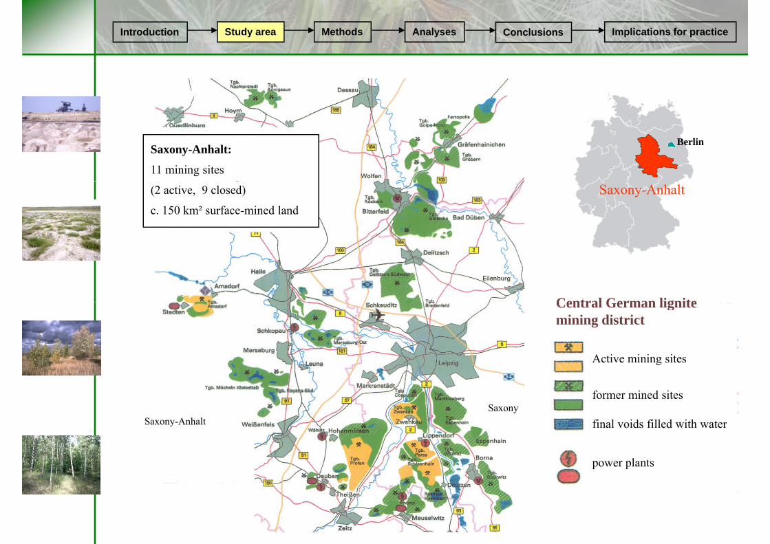
Introduction Study area Methods Analyses Implications for practiceConclusions
Saxony-Anhalt:
11 mining sites
Berlin
(2 active, 9 closed)
c. 150 km² surface-mined land
Saxony-Anhalt
Central German lignite
Active mining sites
Central German lignite mining district
Saxony
ct ve g s tes
former mined sites
final voids filled with waterSaxony-Anhalt final voids filled with water
power plants
Saxony Anhalt

Introduction Study area Methods Analyses Implications for practiceConclusions
Golpa-NordGolpa III
Gräfenhainichen
Bitterfeld
Muldenstein
S A h lt
Berlin
Bitterfeld
Goitzsche-Holzweißig-West
Goitzsche-Halde 1035
Saxony-Anhalt
Saxony
DelitzschHalle
SaxonySaxony-Anhalt
Merseburg
Geiseltal
Leipzig
Kayna-Süd
Mücheln-Innenkippe
Kayna Süd
Rossbach
Domsen-Nordost
NordfeldNordfeldJaucha
Kirmer, A., Tischew, S., Ozinga, W.A., von Lampe, M., Baasch, A., van Groenendael, J.M. (2008) Journal of Applied Ecology 45: 1523-1530.

Introduction Study area Methods Analyses Implications for practiceConclusions
Bitterfelder / Gräfenhainicher lignite mining district
mined site approx. age extension
Golpa-Nord, Bachaue (2 -) 14 years 1 km²
Golpa III (6 -) 50 years 2.5 km²Gräfenhainichen
Golpa-NordGolpa III
Muldenstein, Burgkemnitz 38 years 0.8 km²
Goitzsche Halde 1035 (3 ) 40 years 0 6 km²
Muldenstein
Goitzsche, Halde 1035 (3 -) 40 years 0.6 km
Goitzsche,Holzweißig-West (4 -) 30 years 1.8 km²Goitzsche-Halde 1035
Bitterfeld
Goitzsche-Holzweißig-West
All sites developed spontaneously (only small parts were recultivated) and contain only small areas with inhospitablerecultivated) and contain only small areas with inhospitable tertiary substrate (pH <3)

Introduction Study area Methods Analyses Implications for practiceConclusions
Mined site Muldenstein, nature reserve “Burgkemnitz”
Extension of the study site: 0.8 km²
regrading stopped in 1962regrading stopped in 1962
recultivation only at the edges (mostly planting of trees and shrubs)
dominance of moist and wet site conditions; in parts dry and sandy; p y y

Introduction Study area Methods Analyses Implications for practiceConclusions
Mined site Muldenstein, nature reserve “Burgkemnitz”
Isolepis setacea
293 plant species, 21 endangered
Dactylorhiza maculata
Centaurium pulchellum Utricularia australis Eriophorum angustifolium Armeria maritima

Introduction Study area Methods Analyses Implications for practiceConclusions
Mined site Goitzsche, Holzweißig-West, landscape protection area
Extension of the study site: 1.8 km²
regrading of the main area stopped in 1972; in parts in 1996regrading of the main area stopped in 1972; in parts in 1996
only small parts recultivated (mostly planting of trees and shrubs)
mosaic stands with different amount of tertiary and quaternary material;mosaic stands with different amount of tertiary and quaternary material; predominance of sandy substrate
extremely dry and nutrient-deficient
pH values 3-6 (predominance of acid substrate)

Introduction Study area Methods Analyses Implications for practiceConclusions
Mined site Goitzsche, Holzweißig-West,landscape protection area
Dianthus deltoides
Corynephorus canescens208 plant species, 11 endangered
Jasione montana
Saxifraga granulataCentaurium erythraeaFilago arvensis Helichrysum arenarium

Introduction Study area Methods Analyses Implications for practiceConclusions
Geiseltal / Profener lignite mining district
mined site approx. age extensionMerseburg pp g
Mücheln/Innenkippe (2 -) 41 years 2.6 km²
Kayna Süd (3 ) 34 years 1 8 km²
Mücheln-Innenkippe
Kayna-Süd (3 -) 34 years 1.8 km²
Roßbach (1 -) 23 years 2.3 km² Kayna-Süd
RossbachDomsen-Nordost
Domsen 27 - 41 years 1 km²
Nordfeld Jaucha 26 - 55 years 1 km²NordfeldJaucha
All sites developed spontaneously (only small parts with recultivation) and contain only small areas with inhospitable tertiary material (pH <3)

Introduction Study area Methods Analyses Implications for practiceConclusions
Mined site Kayna-Süd, southern part, Natura 2000 site
Extension of the study site (without water body): 1.8 km²
mining stopped in 1972; regrading of the south-western shore until 1978
l i i l h drecultivation only at the edges
Substrate: gravel and carbonate-rich sand or loam, in parts with high amount of ligniteg
pH values: 3 - 7

Introduction Study area Methods Analyses Implications for practiceConclusions
Mined site Kayna-Süd, southern part, Natura 2000 site
Pulicaria dystenterica
284 plant species, 30 endangered
Ophrys apifera
T if liTrifolium aureum
Erucastrum nasturtiifoliumAchillea nobilis
Epipactis atrorubens
Dactylorhiza incarnata
Ophioglossumvulgatum

Introduction Study area Methods Analyses Implications for practiceConclusions
Mining site Mücheln, Innenkippe, nature reserve
Extension of the study site: 2.6 km²
mining stopped in 1961; regrading of the eastern part in 2000mining stopped in 1961; regrading of the eastern part in 2000
recultivation only at the edges
Substrate: quaternary loam and silt; in parts with lime; high amount of ligniteSubstrate: quaternary loam and silt; in parts with lime; high amount of lignite
pH values 4-7

Introduction Study area Methods Analyses Implications for practiceConclusions
Mining site Mücheln, Innenkippe, nature reserve
Anagallis foeminaAnagallis foemina
273 plant species, 23 endangeredScorzonera laciniata
Dianthus carthusianorum
Linum austriacumEpipactis palustrisThymelaeapasserina Centaurea diffusaBotrychium lunaria

Introduction Study area Methods Analyses Implications for practiceConclusions
Special situation in post-mining landscapes in eastern Germany
During GDR times: mining sites were
p p g p y
During GDR times: mining sites were forbidden zones with limited access due to their economical importance
1949 - 1998: floristic mappings without implementation of mining areas
1994 - 2002: several research projects with thorough botanical assessments in gmined areas
two data sets for analysisFinal void Rösa, mined site Goitzsche, photo: Alrun Albrecht 1994
two data sets for analysis

Introduction Study area Methods Analyses Implications for practiceConclusions
Floristic Mapping of higher plants in Germany(Schönfelder, P. 1999: Mapping the flora of ( , pp gGermany. Acta Bot. Fennica 162: 43–53)
Mapping is based on grid cells with 5 5 k h i5.5 km mesh size

Introduction Study area Methods Analyses Implications for practiceConclusions
mined sites: lists of plant species
surrounding area: data from the fl i ti i f th t t
4536-3 4539-34538-44538-34537-44537-34536-4
floristic mapping of the states Saxony-Anhalt and Saxony (after 1949)
4636-1 4639-14638-24638-14637-24637-14636-2
4636 3 4639 34638 44638 34637 44637 34636 44636-3 4639-34638-44638-34637-44637-34636-4
4736-1 4739-14738-24738-14737-14736-2 4737-2
<3km (1 grid cell)
categories
4736-3 4739-34738-44738-34737-44737-34736-4
mined site
3-10km (8 grid cells)
10 17km (16 grid cells)
4836-1 4839-14838-24838-14837-24837-14836-2
10-17km (16 grid cells)
>17km4836-3 4839-34838-44838-34837-44837-34836-4
5.5km
Kirmer, A., Tischew, S., Ozinga, W.A., von Lampe, M., Baasch, A., van Groenendael, J.M. (2008) Journal of Applied Ecology 45: 1523-1530.

Introduction Study area Methods Analyses Implications for practiceConclusions
Definition of species pools
Geographical Species Pool (GSP) = species that are present in the whole region. The abundance of these species is expressed by the number of occupied 30.25 km² grid cells.
Species filter: Species able to grow under mining site conditions
Habitat Species Pool (HSP)
= species that are present in the whole region and have proved to be able to grow under
i i i di i Th b d f h
Species filter: Species able to grow under mining site conditions
Environmental filter (specific site conditions in mined site)
p ( )mining site conditions. The abundance of these species is expressed by the number of occupied 30.25 km² grid cells (subset of GSP).
Regional Species
Regional Species
Regional Species
= species from the habitat species pool that occurred in 0-17 km distance of each mined it d bl t i th ifi i dSpecies
Pool 1Species Pool 2
Species Pool n
site and are able to grow in the specific mined site. The abundance of these species is expressed by the number of occupied 30.25 km² grid cells (subset of HSP).
Actual Species
Actual Species
Actual Species
= species that are already present in the examined mined sites.
g ( )
Pool 1 Pool 2 Pool n

Introduction Study area Methods Analyses Implications for practiceConclusions
Species traits used in analyses
• Distance of the next seed source to the respective mined site • Affiliation to the northern or southern mining region• Ellenberg indicator values• Ellenberg indicator values
light availabilitymoisturenitrogen availabilitynitrogen availability
• Seed weight (mg)• Terminal velocity of seeds (m/sec)• dispersal strategy type
wind (anemochor)birds (ornithochor)fur (epizoochor)fur (epizoochor)ants (myrmekochor)self (autochor) water (hydrochor)water (hydrochor)
Data compiled from: Bioflor database (Frank et al. 1990), von Lampe (unpubl.), IRIS/LEDA database; database higher plants & selective biotope mapping in Saxony-Anhalt (Landesamt für Umweltschutz Sachsen-Anhalt, Halle) working status 1998; database higher plants in Saxony (Sächsisches Landesamt für Umwelt und Geologie, Dresden)

Introduction Study area Methods Analyses Implications for practiceConclusions
Question 1:
Do special features of the two mining regions affect the occurrence of plant species in the
i i d i ?respective mined sites?

Introduction Study area Methods Analyses Implications for practiceConclusions
Southern region Northern region
decideous woodland
mixed woodland
coniferous woodland Study sites
Landsat 7 ETM+ (14/08/2000); Digital segment based analysis
g garable land
grassland
tall herb community
dry grassland
y
( ); g g y(University of Halle, Institute for Geography, Prof. Dr. Gläßer)
dry grassland
bare soil
water
settlements

Introduction Study area Methods Analyses Implications for practiceConclusions
Proportion of different land use on 35 km x 40 kmbased on Landsat 7 ETM+ (14/08/2000); Digital segment based analysis
(University of Halle, Institute for Geography, Prof. Dr. Gläßer)
Southern region Northern region
Deciduous woodland4,6%
Mixed woodland1,2%
Raw soil
water0,8%
settlements4,6%
Mixed woodland
6 1%
Deciduous woodland2,5%
settlements3,3%Raw soils
0,3%
Dry grasslands3,3%
water0,7%
1,2%
Tall herb communities19,6%
0,0%
Mesic
6,1%Tall herb communities
9,8%
3,3%
Mesic grassland1,2% coniferous
woodland
42,2%
grassland8,3%
Arable land67,9%
Arable land23,5%

Introduction Study area Methods Analyses Implications for practiceConclusions
Differences between the northern and southern regionLand cover based on a classification of satellite images *g
(Landsat7 ETM+, 14.08.2000)
average number of species from the regional species poolin the 0-3km surrounding area
structures, relevant for colonisation processes arable land
259 (+/- 46)South 26.6 % 67.9 %
455 (+/- 60)North 72.2 % 23.5 %
southern region: structure- and species-poor
northern region: structure- and species-rich
* Nocker, U. & Gläßer, C. „The contribution of remote sensing and GIS for registration at vegetation structures in the surrounding of former open-cast mining areas“ (Univ. Halle, Institute for Geography, unpubl. data)

Introduction Study area Methods Analyses Implications for practiceConclusions
Question 2:
How far away are the next occurrences of plant species already growing in the mined sites?

Introduction Study area Methods Analyses Implications for practiceConclusions
Distance of species in mined sites to possible seed sources
percentage of established species in mined sites (n=10)100
75
23 % of already established species in mined siteshave possible seed sources in > 3 km distance!50
25
0< 3 km 3 – 10 km 10 – 17 km > 17 km
Distance to next occurrenceNorthern mining region
Southern mining region
Kirmer, A., Tischew, S., Ozinga, W.A., von Lampe, M., Baasch, A., van Groenendael, J.M. (2008) Importance of regional species pools and functional traits in colonisation processes: predicting re-colonisation after large-scale destruction of ecosystems. Journal of Applied Ecology 45: 1523-1530.

Introduction Study area Methods Analyses Implications for practiceConclusions
Question 3:
Which dispersal strategies are most successful for immigration of plant species into the mined sites?

Introduction Study area Methods Analyses Implications for practiceConclusions
Successful dispersal strategy types for immigration into mined sites (%) n=10
70
80(%) n 10
***
50
60
30
40
50
20
30
* *** ****** ***
0
10
immigrated species fromnot immigrated species from
antsfur selfbirdswind water
immigrated species from 0-3 km distance to the mined site
not immigrated species from 0-3 km distance to the mined site

Introduction Study area Methods Analyses Implications for practiceConclusions
Differences in species traits important for LDD
All species Only non-Red List Only Red List
Immigrant Non immigrant Immigrant Non immigrant Immigrant Non immigrantImmigrant Non-immigrant Immigrant Non-immigrant Immigrant Non-immigrant
seed weight [mg] 2.09 2.76 2.12 2.88 0.82 1.11n 1828 1411 1787 1315 41 96
± SE 0 11 0 17 0 11 0 18 0 16 0 12± SE 0.11 0.17 0.11 0.18 0.16 0.12P (U-test) *** ***
terminal velocity [m/s] 1 99 2 39 2 01 2 42 1 36 1 94terminal velocity [m/s] 1.99 2.39 2.01 2.42 1.36 1.94n 1656 1078 1610 1007 46 71
± SE 0.03 0.04 0.03 0.04 0.22 0.16P (T-test) *** *** *
SE = standard error; P = level of significance between immigrant vs. non-immigrant species.
Differences in seed weight and terminal velocity between immigrated and non-immigrated species (without phanerophytes and nanophanerophytes) of the regional species pools in the surroundings of 0-3 km of the mined sites were tested using either T-test (Levene test >0.05) or U-test (Levene test ≤ 0.05) depending on the normal distribution of the data. Significance levels were indicated in the following way: [*] 0.05≥P>0.01; [**] 0.01≥P>0.001; [***] P≤0.001. The number of cases in the analysis depended on the availability of data for seed weight and terminal velocity
ll h f i i h i i l i las well as the occurrence of species in the respective regional species pools.

Introduction Study area Methods Analyses Implications for practiceConclusions
Question 4:
Which traits/parameters proved to be significant for the occurrence of plant species in the actual species
l f h i d i ?pools of the mined sites?
Method: Binary logistic regression with forward selection. Criterion for inclusion of variables in the forward selection was a probability of 0.05.

Introduction Study area Methods Analyses Implications for practiceConclusions
Variables for Binary Logistic Regression Analysis
ASP actual species pool (dependent variable)HSP habitat species pool RSP 0 17 i l i lRSP 0_17 regional species pool distance nearest distance to the respective mined site, ranging from class 1 (c. 0-3 km)
to class 10 (c. 59-66 km)th th ffili ti t th th th i i inorth_south affiliation to the northern or southern mining region
light availability Ellenberg indicator for light availabilitymoisture Ellenberg indicator for moisturenitrogen availability Ellenberg indicator for nitrogen availabilityseed weight class ranging from 1 (light) to 8 (heavy), dependent on the seed weightseed longevity persistence in the soil seed bank (classified with the seed longevity index
ranging from 0 = low to 1 = high) terminal velocity terminal velocity of seeds [m/s]dispersal potential wind capacity for long distance dispersal by wind (0=low, 1=high)p p p y g p y ( g )dispersal potential water capacity for long distance dispersal by water (0=low, 1=high)dispersal potential fur capacity for long distance dispersal by fur of animals (0=low, 1=high) dispersal potential dung capacity for long distance dispersal by dung of mammals (0=low 1=high)dispersal potential dung capacity for long distance dispersal by dung of mammals (0 low, 1 high) dispersal potential birds capacity for long distance dispersal by bird droppings (0=low, 1=high)

Introduction Study area Methods Analyses Implications for practiceConclusions
Binary Logistic Regression Analysis
Variable Regression Wald d.f. P Nagelkerke R²coefficient
regional species pool 0-17 km 0.090 62.486 1 ≤0.0005 0.235terminal velocity -0.224 29.268 1 ≤0.0005 0.276light availability 0.166 28.106 1 ≤0.0005 0.284habitat species pool 0.014 31.660 1 ≤0.0005 0.289dispersal potential wind -0.614 20.667 1 ≤0.0005 0.295nitrogen availability -0.082 16.342 1 ≤0.0005 0.299distance -0.267 8.426 1 0.0037 0.302dispersal potential birds -0.514 4.323 1 0.0376 0.303p p
constant -1.667 16.752 1 ≤0.0005
The regression coefficient indicates a positive or negative effect of the independent variable. Wald statistic = measure of the relative effect size of the variable in the full model.Nagelkerke R2 = cumulative proportion of explained variance after entrance of the variable in the model.

Introduction Study area Methods Analyses Implications for practiceConclusions
Question 5:
How successful are Red List plant species in colonising the mined sites?
Saxony-Anhalt: 717 Red List Plant SpeciesMined areas: 100 (= 14 %)

Introduction Study area Methods Analyses Implications for practiceConclusions
Successful establishing events of Red List Plant Species in mined sites
Number of mined sites with successfully established Red List Species1 2 3 4 5 6 7 8 9 101 2 3 4 5 6 7 8 9 10
Next occurrence<3 km 18 5 9 6 10 3 8
3-10 km 20 8 5 11 4 8 23 10 km 20 8 5 11 4 8 210-17 km 9 2 1 3 1 3
>17 km 1 3 3Total number of Red List Species 48 9 6 5 3 0 2 0 0 1
Botrychium lunariaFilago arvensis
e.g.Achillea nobilisA lli f i
Dactylorhiza fuchsiiGymnadenia conopseaHieracium zizianumP t t b ht ldii
Cornus masErucastrum nasturtiifoliumDactylorhiza maculataPlatanthera chloranthaScleranthus polycarpos
Centaurea diffusaCentaurium pulchellum
Hi i b hi i
Dactylorhiza incarnata agg.Epipactis palustrisOphioglossum vulgatum
Anagallis foeminaBotrychium matricariifoliumCampanula glomerataCarex viridulaCarum carviCentaurium pulchellum
Hieracium piloselloides
Potamogeton berchtoldiiPulicaria dysentericaRhinanthus minorSalix repensTrifolium aureumUt i l i l i
Verbena officinalis Hieracium bauhiniOphrys apifera Sanguisorba officinalis
pChimaphila umbellataDactylorhiza maculataDigitaria ischaemumDiplotaxis muralis Eleocharis acicularisE i ti l t i Utricularia vulgaris agg.Epipactis palustrisTorilis arvensis

Introduction Study area Methods Analyses Implications for practiceConclusions
Traveller over far distances ...
A hill bili
Erucastrum nasturtiifoliumk
Pulicaria dysentericanext occurrence 3-10 kmRed List Saxony-Anhalt 3
Achillea nobilisnext occurrence 10-17 kmRed List Saxony-Anhalt 3
Thymelaea passerinanext occurrence >17kmRed List Saxony-Anhalt 0
y pnext occurrence (before1949) 10-17 kmRed List Saxony-Anhalt 0
Chimaphila umbellataOphrys apiferaBotrychium matricariifoliumnext occurrence >17 kmRed List Saxony-Anhalt 0
Dactylorhiza maculatanext occurrence 3-10 kmRed List Saxony-Anhalt 3
Chimaphila umbellatanext occurrence 3-10 kmRed List Saxony-Anhalt 1
Ophrys apiferanext occurrence 3-10 kmRed List Saxony-Anhalt 3

Introduction Study area Methods Analyses Implications for practiceConclusions
Question 6:
Is it possible to detect long-distance dispersal events via seed traps?

Introduction Study area Methods Analyses Implications for practiceConclusions
Results from seed trap experiments
• 2 mined sites (Kayna-Süd, Mücheln Innenkippe)Innenkippe)
• each with three 5m x 5m plots on lignite-rich raw soil with very low
t tivegetation cover
• each plot with five seed traps (plastic funnels; Fischer 1987) with 24.1 cm diameter
• each funnel with a catching area of 456 cm²
• samples were taken between May 2000 and May 2001 in regular intervals
Seed traps in Kayna-Süd, photo: Sandra Mann 2000intervals
• in Kayna-Süd, one plot had been destroyed

Introduction Study area Methods Analyses Implications for practiceConclusions
Average number of seeds/m²4000Results from seed trap experiments
• all species found in the seed traps occur very frequently in the mined i d i h i i i f h 2000
3000
sites and in the vicinity of the traps
• total number of species: Kayna-Süd 13 Mücheln 30
1000
K Süd (KS) ( 10) Mü h l I ki (MI) ( 15)
Kayna-Süd 13, Mücheln 30
• only 2 species were found in 100-300 m distance to the seed traps; all other
0May2000 - May 2001
Kayna-Süd (KS) (n=10) Mücheln Innenkippe (MI) (n=15)
Average number of species in seed traps
pspecies are present within 100 m distance to the seed traps (consistent with other seed trap experiments in 25
mined sites: Tischew, unpubl. data, Kirmer 2004)
d t t b t it bl t15
20
seed traps seem to be not suitable to detect long-distance dispersal events
5
10
0May2000 - May 2001
Introduction Study area Methods Analyses Implications for practiceConclusions
Large distance dispersal e ents are ass med to be er rare to obser e
Long-distance dispersal in cultural landscapes – evidence from lignite mines (1)
Large-distance dispersal events are assumed to be very rare to observeMining areas act as ”large seed traps” in the landscape and accumulate species during several decades
It is difficult to proof successful colonisation resulting from long-distance dispersalSeed traps are not suitable because of the small catching area. Colonisation of areas starting with primary succession can be used as an indirect proof for LDD if data of the surrounding area are available (e.g. del Moral et al. 2005, Kirmer et al. 2008).
Colonisation in small-scale restoration trials is often limited (e.g. Verhagen et al. 2001, Bischoff 2002) Mining areas have a very large extension with many niches for establishment. The high amount of species immigrating only once or twice into the study sites indicates that LDD events are not regular and both small-scale restoration sites and short time frames will impede successful colonisation.
Wind is an efficient vector for LDD especially in weather conditions characterised by p y ythermal turbulence and updrafts (e.g. Tackenberg et al. 2003, Nathan et al. 2005) Mining areas are often located in structure-poor industrial landscapes with a high wind permeability. But also non-standard means of dispersal (e.g. Higgins et al. 2003) are often responsible for LDD
t i d di d d ti b di d b bi devents: wind-dispersed seeds may sometimes be dispersed by birds.
• Abundance in the regional species pool is more important than the actual distance of the next seed source It seems that a higher seed pressure is more effective than occurrence in the vicinity of the mined site

Introduction Study area Methods Analyses Implications for practiceConclusions
Long-distance dispersal in cultural landscapes – evidence from lignite mines (2)
Effective dispersal strategy types (e.g. wind, birds) with functional traits related to LDD (e.g. low terminal velocity) improve the chance for immigrationRare species with a generally low abundance in the surrounding areas can nevertheless accumulate in the mined sites because they have small seeds and a low terminal velocity and can therefore bridge relatively large distances (e.g. Ash et al. 1994: up to 40 km).
• Site conditions typical for pioneer sites (high light availability low nutrient content)• Site conditions typical for pioneer sites (high light availability, low nutrient content) enhance the chance of establishmentIn times of increasing nutrient availability (Pearson & Dawson 2005), plant nutrient requirements can outrank LDD (Soons & Ozinga 2005). Especially species, adapted to open, nutrient-deficient ( g ) p y p , p p ,habitats will profit from mining site conditions. In the mined sites, the amount of nutrient-demanding species is very low. .
After large scale open cast mining colonisation ia spontaneo s s ccession is leading• After large-scale open-cast mining, colonisation via spontaneous succession is leading to valuable biotope mosaics with habitats for many rare and endangered plant speciesIn the federal state Saxony-Anhalt, 36 % of all higher plants are growing in former and active mining sites (Saxony-Anhalt: 20443 km², mining areas: 150 km² = 0.7 % )mining sites (Saxony Anhalt: 20443 km , mining areas: 150 km 0.7 % )

Introduction Study area Methods Analyses Implications for practiceConclusions
Implications for restoration practice
• Selection of large-scale areas (at least 400 ha, optimal 2000 ha) ( low disturbance, low
Creation of favourable conditions for spontaneous succession in active mining sites
Selection of large scale areas (at least 400 ha, optimal 2000 ha) ( low disturbance, low nutrient input from the surroundings)
• Influence on the final dumping of substrate and on relief shaping in the final phase of p g p g pmining activities (high heterogeneity of substrate)
• Intentional preservation or creation of varied structures, such as e.g. hollows, tips, areas with shallow water, variously shaped shores and slopes (high heterogeneity of geomorphological structures)
• Permission for dynamic processes under consideration of slope stability (high dynamic)
high niche availability

Introduction Study area Methods Analyses Implications for practiceConclusions
Implications for restoration practice
• In German mining plans usually 10-15 % of the area should be designated as priority areas for “Nature and Landscape”
• Traditional restoration strategies should be limited for the benefit of spontaneous succession
• The colonisation of mining sites by plants is influenced by the species pool of a relatively wide margin (up to 20 km)
• Especially in structure-poor, intensively used landscapes, mining sites should consist of large, nutrient-poor areas that were decisive for the gradually accumulation of suitable plant speciesaccumulation of suitable plant species

Introduction Study area Methods Analyses Implications for practiceConclusions
BUT:BUT:Our results should not facilitate decisions to open new mining sites in
ith l bl h bit t diffi lt t tareas with valuable habitats difficult to restore
only in industrial landscapes mining of mineral resources (e.g. lime, sand, lignite) in combination with appropriate ecological restoration (preservation of large nutrient-combination with appropriate ecological restoration (preservation of large, nutrientpoor sites with heterogeneous site conditions without recultivation measures) will lead in the end to the spontaneous development of biotope mosaics that offer habitats for
th t d l t d i l imany threatened plant and animal species.

Dank
Thanks to all co-workers, PhD and diploma students who contributed to the work:
AlrunAlrun Albrecht, Annett Albrecht, Annett BaaschBaasch, Mareike Conrad, Sandra , Mareike Conrad, Sandra DullauDullau, Daniel Elias, Antje , Daniel Elias, Antje FliegnerFliegner, Astrid Grüttner, Antje Lorenz, Sabine Jakob, Gerd Jünger, Andreas , Astrid Grüttner, Antje Lorenz, Sabine Jakob, Gerd Jünger, Andreas
Lebender, Sandra Mann, Michael Reuter, Matthias Stolle, Ines Lebender, Sandra Mann, Michael Reuter, Matthias Stolle, Ines ScheiblerScheibler, Michael , Michael SeppeltSeppelt, Sabine , Sabine TischewTischew
Modelluntersuchungen zur Gestaltung von Bergbaufolgelandschaften auf der Basis spontaner und gelenkter Sukzessionen unter Berücksichtigung von Aspekten des Naturschutzes am Beispiel des B k hl t b G it hBraunkohlentagebaus GoitzscheDeutsche Bundesstiftung Umwelt, FKZ 03268, 1994-1996
Forschungsverbund Konzepte für die Erhaltung, Gestaltung und Vernetzung wertvoller Biotope und Sukzessionsflächen in den Bergbaulandschaften Mitteldeutschlands (FBM)Sukzessionsflächen in den Bergbaulandschaften Mitteldeutschlands (FBM)BMBF, FKZ 0339647, 1996-1998
Forschungsverbund Landschaftsentwicklung Mitteldeutsches Braunkohlenrevier: Analyse, Bewertung und Prognose der Landschaftsentwicklung in Tagebauregionen des Mitteldeutschen Braunkohlerevieresund Prognose der Landschaftsentwicklung in Tagebauregionen des Mitteldeutschen Braunkohlerevieres (FLB)BMBF, FKZ 0339747, 1999-2003
Successful Restoration and Rehabilitation Accompanying Infrastructural Interventions (SURE) p y g ( )Interreg IIIB CADSES, FKZ 3B071, 2004-2006

Th k Y f Y tt ti !Th k Y f Y tt ti !Thank You for Your attention!Thank You for Your attention!