LONDON - MAPS, PRINTS & BOOKS - Heywood Hill
24
LONDON - MAPS, PRINTS & BOOKS SAYER, J.P. (John Pearson) Survey of London Series. Published by the Strand Magazine 1947. Map 275 x 200mm. In mount 360 x 300mm. £95.00 each Sayer was a British artist, illustrator and graphic designer. He is best remembered for the posters that he designed for the Great Western Railway Company in the interwar years. 1 Bird’s-eye View of Hyde Park Corner. Together with some Particular Notes concerning Apsley House and its illustrious Owner, Field Marshal The Duke of Wellington.
Transcript of LONDON - MAPS, PRINTS & BOOKS - Heywood Hill

LONDON - MAPS, PRINTS & BOOKS
SAYER, J.P. (John Pearson)
Survey of London Series. Published by the Strand Magazine 1947.
Map 275 x 200mm. In mount 360 x 300mm. £95.00 each
Sayer was a British artist, illustrator and graphic designer. He is best
remembered for the posters that he designed for the Great Western Railway
Company in the interwar years.
1 Bird’s-eye View of Hyde Park Corner. Together with some Particular Notes
concerning Apsley House and its illustrious Owner, Field Marshal The Duke of
Wellington.

2 Two Maps of Charing Cross: so displayed that the Changes caused by
the Construction of Trafalgar Square may be Conveniently studied. To form the
Sixth Part of the Survey of London.
3 A Great New Survey of London, 1946. Part the First: Map of The
Strand from Wellington Street to Temple Bar. Accomodated to display all
the most Noteworthy Buildings and to give many Historical and Topical
Particulars, with other Authentick and Diverting Information.
4 A Map of Piccadilly between the Green Park and Piccadilly Circus.
Being the Second Part of the Survey of London.

5 A Prospect of St. James’s Park: being the Seventh Part of the Survey of
London.
6 A Map Showing the Royal Exchange and the Streets in its
neighbourhood. together with Notes concerning certain Historic Buildings and
Worthy Citizens. Being the Fifth Part of the Survey of London.
7 Fleet Street displayed: the third Map of the Survey of London.

8 A Map of the Strand from Trafalgar Square to Aldwych. Being the
Ninth Section of the Survey of London.
9 A Map of Blackfriars and New Bridge Street: including some
Particulars of the famous Buildings formerly in this Locality and a brief
Description of the Fleet River. The Eighth Part of the Survey of London.
10 A Prospect of Westminster: as it appears today showing the Abbey,
Westminster Hall, the School, the Houses of Parliament, St. Margaret’s Church
etc... The Fourth Part of the Survey of London.

London Underground Maps
11 [LONDON UNDERGROUND MAP] The Evening News London
“Tube Map”. £295.00.
George Philip & Son, Ltd. The London Geographical Institute. [c.1912]
Folding lithographic map of London underground lines printed in colours,
issued by a London daily newspaper.
With map of tram routes printed to verso. Marginal ink stain, a couple of small
grease and other spots consistent with age. Full sheet 505 x 610mm, 20 x 24 ins.

Maps from this period still show the tube lines superimposed geographically
over a simplified road map. The Evening News was published from 1881 to
1980, reappearing briefly in 1987.
12 LONDON TRANSPORT MAP Underground Railways of London.
Map of the Electric Railways of London. What To See & How To Travel.
£500.00
London, Waterlow & Sons Ltd [Printers] June 1924.
Official folding lithographic map of London Underground routes, printed in
colours. “Issued Free” to visitors to the British Empire Exhibition held at
Wembley Park, Wembley (23rd April 1924 to 31st October 1925).
With key, and extensive tourist information to verso, including a West End
‘Theatre Plan’. Full sheet 370 x 455mm, 14½ x 18 ins.

Designed to be carried in the pocket in all conditions, the Underground maps
from this period rarely survive in such good condition. Showing the tube lines
superimposed geographically over a simplified road map, it was not until 1933
that Harry Beck’s ‘electrical circuit’ design - still the basis of today’s
diagrammatic maps - dispensed with conventions of scale, accurate bearing and
all surface landmarks.
13 LONDON TRANSPORT MAP
London General Omnibus Company. L.G.O.Co. Map. £350.00
London, May 1914
Official folding lithographic map of London bus routes, printed in black, red
and green.
With inset key and route notices, and with enlarged central London services
map and timetables to verso. Some weaker folds expertly repaired. Full sheet
310 x 455mm, 12¼ x 18 ins.

Designed to be carried in the pocket in all conditions, this is a rare survival of
pre-World War I London transport ephemera.
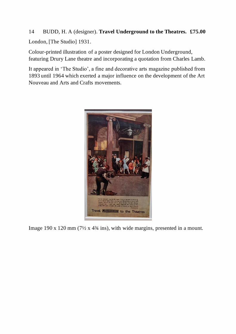
14 BUDD, H. A (designer). Travel Underground to the Theatres. £75.00
London, [The Studio] 1931.
Colour-printed illustration of a poster designed for London Underground,
featuring Drury Lane theatre and incorporating a quotation from Charles Lamb.
It appeared in ‘The Studio’, a fine and decorative arts magazine published from
1893 until 1964 which exerted a major influence on the development of the Art
Nouveau and Arts and Crafts movements.
Image 190 x 120 mm (7½ x 4¾ ins), with wide margins, presented in a mount.

15 STERN, Simon (Designer). Daily Telegraph Picture Map of London.
London, Geographia Ltd c.1960s.
Large folding photolithographic map in colour. Surrounded by by a decorative
border featuring pictograms representing ceremonial and everyday London life.
Presumably a supplement to an edition of the national newspaper. Sheet 645 x
950mm, 25½ x 37½ ins.
Some slight loss of print to two or three of the folds.
16 PHILIP, George (publisher). [MAP] City of London. £95.00
The London Geographical Institute [c.1907]
Chromolithographic street plan-cum-bird’s-eye view, showing part of
Southwark in the foreground, connected by four road and two rail bridges
across the Thames.

Sheet 175 x 220 mm, 7 x 8¾ ins, mounted. Centrefold.
Plate 57 from the Handy-Volume Atlas of London.
17 LEAFY WEST LONDON
[MAP] KNIGHT, Charles (publisher). Western London. £150.00
London, Charles Knight [n.d., c.1850s]
Lithographic map printed in colours, in a double-ruled border.
Sheet 370 x 270 mm, 14½ x 10½ ins, mounted. Light age toning to extremities
only.

Originally published in a series of three maps covering western central London,
eastern central London and the environs of London. The West End, Mayfair,
Westminster, Marylebone, Belgravia, Pimlico and Chelsea are covered. It pre-
dates the completion of Chelsea Bridge in 1858.
18 BACON, G.W (publisher). [MAP] [London’s West End.] £75.00
London, [c.1907]
Chromolithographic map in colour, extending from St. Paul’s in the East to
Green Park in the West, also showing parts of the South Bank and Lambeth. In
an oval, with decorative border and monotone illustrations of Windsor Castle,
the Tower, Houses of Parliament and Westminster Abbey to the four corners.

Sheet 175 x 210 mm, 7 x 8¼ ins. Centrefold.
19 BARTHOLOMEW, John (Publisher). Bird’s-Eye View Map of Central
London. £60.00
Edinburgh, c.1922
Original chromolithograph, for the Pocket Atlas of London.

WILLIAM NICHOLSON LONDON TYPES
Mounted colour lithographs after the original woodblocks taken from an
incomplete copy of the first US edition of ‘London Types’ New York, R.H.
Russell 1898.
385 x 415mm in mount.
£150.00 each
The accompanying poem by W.E. Henley affixed to back of the mount. Painter-
printmaker Sir William Newzam Prior Nicholson (1872-1949) worked in an
artistic design partnership with his brother-in-law James Pryde, known as the
'Beggarstaff Brothers'. He went on to illustrate many books, including those of
Robert Graves, and the much-loved children's book 'The Velveteen Rabbit'. He
produced two other famous sets of woodcuts, 'An Alphabet' and 'An Almanac of
Twelve Sports'.
20 Bluecoat Boy.

21 Coster.
22 Hawker.

23 News-Boy.
24 Policeman.

25 Sandwich-Man.
Books on London
26 PYNE, W. H. The History of the Royal Residences... of Windsor
Castle, St. James’s Palace, Carlton House, Kensington Place, Hampton Court,
Buckingham House, and Frogmore.
London, A. Dry 1819. £4,500.00
First edition, with 100 fine hand-coloured aquatint plates, many heightened with
gum arabic. Bound without the List of Portraits in Vol. 3. List of Plates bound
into Volume 1.
4to., three volumes. Fine contemporary straight grained morocco, with large
gothic architectural device in gilt to centre of boards, these with elaborate gilt
borders, spines richly gilt in compartments with further gothic devices, all edges
gilt, with fine glazed endpapers & elaborate gilt dentelles; with later slipcases,
all bar one with chemise.
With the bookplates of Neil Edmonstone, Annie Burr Jennings, and Helen
Hanle Madison.

A striking copy of this classic work, from the library of the East India Company
civil servant Neil Benjamin Edmonstone (1765-1841) with his bookplate on the
front pastedown of each volume. Later from the library of Annie Burr Jennings
with her leather monogram bookplate with the motto “Otium sine literis mors
est” (leisure without literature is death). Annie Burr Jennings (1855-1939) was
a New York philanthropist and heir to a Standard Oil fortune. A serious book
collector, over 3000 volumes from her collection were donated to Yale in 1940
by her niece Annie Burr Auchincloss, wife of Wilmarth "Lefty" Lewis. And with
a later yet bookplate of Helen Hanle Madison.
William Henry Pyne (1770–1843), was an artist and printmaker in his own
right, who commissioned the artists and engravers of these plates, with their
particularly fine hand-colouring, to show an exact record of the interiors of the

royal residences in the year prior to George III’s death in 1820. They included
Carlton House, the Prince Regent’s London home. This magnificent building,
which had been the home of Lord Burlington prior to its purchase by George
III’s mother, was demolished in 1825 and replaced by the two imposing
terraces which make up Carlton House Terrace.
The illustrations have been consulted by art historians, curators and archivists
at the royal collection to research interior schemes and decorative fashions,
down to such details as the arrangements of the hanging of pictures.
Abbey, 396.
27 EVANS, Charles (Publisher). Grand Panorama of London and the
River Thames. £995.00
Extending from the New Houses of Parliament to Greenwich Hospital.
London, Charles, Evans, et al. 1849
Uncoloured wood-engraved panoramic view of the North bank of the Thames,
printed on on six conjoined sheets and folding concertina-style into the
publisher's blindstamped cloth boards (oblong 8vo.). The title printed in red and
mounted on to the front pastedown, and repeated over a blocked vignette of St
Paul’s Cathedral in gilt to upper board.
Binding a little stained and soiled, the spine a little faded. One prominent ‘rust
spot’ penetrating upper cover and with decreasing traces through the first four
leaves, otherwise a good sharp impression free of significant staining save

vertical lines of discolouration where sheets fold and join. Sheet 150 x 4860 mm
fully extended.
Buildings and points of interest are captioned in letterpress along the lower
margin. Showing the heavy river traffic of the mid-19th century metropolis and
- from West to East - Westminster, Hungerford, Waterloo, Blackfriars,
Southwark and London bridges.
28 HUGHSON, David. Walks Through London: Including Westminster
and the Borough of Southwark, with the Surrounding Suburbs... Forming a
complete Guide to the British Metropolis. £550.00
London, Sherwood, Neeley & Jones, et al. 1817
8vo., two volumes, 18 engraved street maps, numerous engraved plates, plus
woodcut line illustrations to the text (none are coloured). 19th century half
pebble-grained morocco over marbled boards, spines with raised bands lettered
and tooled in gilt, marbled endpapers, all edges gilt.
Some scattered light foxing, including to the margins of a few plates, a very
good copy overall.

A guide to London, Westminster and Southwark, plus their surrounding suburbs
and the London environs, in 19 walks.
Walks numbered sequentially 1-13, encompassing the first volume and the first
portion of the second volume, deal with the City of London and immediately
adjacent areas, also Westminster and the West End. There follows two walks,
separately numbered I and II, covering Southwark and Lambeth, and bound
towards the rear of Vol. II is a section titled ‘Environs of London’ detailing
excursions south into Surrey, also parts of east London and into what was then
part of Kent, as well as north into Middlesex and as far west as Windsor and
Eton (’Walks I - IV’). The pagination is continuous, in total pp. 368 plus index.
The maps - of central London only - each feature a vignette of a notable
building, engraved by J. Greig. These and the plates are finely printed on india-
laid paper and interleaved throughout the descriptive text.
With the ex-libris bookplate of William George Smith to the front pastedowns.
29 JESSE, J Heneage. Literary and Historical Memorials of London
[with] London and its Celebrities being a Second Series of Literary and
Historical Memorials of London. £995.00
London, Richard Bentley 1847 and 1850
First editions. With plates and folding plans.

8vo., 4 volumes in contemporary half dark green morocco with double gilt
rules, panelled and lettered in gilt on spines with gilt centre tools, top edges gilt.
A handsome set.
John Heneage Jesse (1809-1874), English historian, son of Edward Jesse, was
educated at Eton, and afterward became a clerk in the secretary's department of
the Admiralty. His numerous historical works are written with vivacity and
interest, and, in their own style, are an important contribution to the history of
England. Jesse wrote Literary and Historical Memorials of London (1847),
London and its Celebrities (1850), and a new edition of this work as London: its
Celebrated Characters and Remarkable Places (1871). His Memoirs of
Celebrated Etonians appeared in 1875.

30 LETHABY, W.R. Westminster Abbey Re-Examined. £1,995.00
London, Duckworth 1925
First edition, a special presentation copy to wood carver Frederic Stuttig signed
by 40 colleagues at The Central School of Art and Design on the occasion of his
retirement from teaching, in 1928. The signatures arranged over pp. [7] front
endpapers on separate fancy lines alternately delineated in blue and red ink - see
annexed list of identified signatories - preceded by a calligraphic inscription “by
his Colleagues” to Stuttig in red ink.
8vo., numerous monotone illustrations from the author’s drawings of
architectural facades and details etc., in a bespoke School binding (binder’s
label to rear pastedown) of polished dark tan calf gilt with the dedicatee’s ‘FS’
monogram blocked to upper cover in green and gilt, all edges gilt. A unique and
very attractive copy.
The Central School of Arts and Crafts was established in 1896 by the London
County Council. It became part of the London Institute in 1986 and in 1989
merged with Saint Martin's School of Art to form Central Saint Martins College
of Arts and Design.
William Richard Lethaby (1857-1931) trained and practised as an architect, but
was also a designer, educator, and architectural theorist and historian. He was
a very important influence on art education and on the Arts and Crafts
movement of late Victorian Britain. He served as the first principal of the
Central School from 1896 until 1912, and in 1906 was appointed to the role of
surveyor to the dean and chapter of Westminster Abbey.

Paris-born Stuttig (fl. 1891 - 1934) settled in England before 1891 and married
Mione Violet Cooke in 1911. From the late 1890s he taught wood carving and
gilding at the Central School and at Camberwell.