Distribution and Character of Loess and Loess Soils in Southeastern Idaho
Loess CanyonsCommunity Wildfire Protection Plan
NARRATIVEDeveloped for these Fire Districts
Dawson CountyCozad - Gothenburg - Lexington - Overton
Frontier CountyEustis - Farnam - Maywood-Wellfleet
Gosper CountyElwood
Lincoln CountyBrady - Maxwell - North Platte - Maywood-Wellfleet
Prepared under contract byKimberly Paul Slezak, CF, MEng GIS
forNebraska State Forest Service
In collaboration with
Fire DistrictsEmergency Managers
Local Government
The University of Nebraska-Lincoln does not discriminate based on gender, age, disability, race,color, religion, marital status, veteran’s status, national or ethnic origin or sexual orientation
Loess Canyons CWPP - JULY 30, 2014 2
Table of ContentsIntroduction................................................................................................................1Process.......................................................................................................................3Aerial Views.................................................................................................................3Native Vegetation Data................................................................................................3LANDFIRE...................................................................................................................3No-HARM....................................................................................................................4Weather Affects...........................................................................................................5Historic Fire Activity.....................................................................................................6District Capacity...........................................................................................................6WUI Areas - Mid Plains MAD.........................................................................................7
Eustis Fire District....................................................................................................7Maxwell Fire District.................................................................................................8Maywood - Wellfleet Fire District...............................................................................9North Platte Fire District.........................................................................................10
WUI Areas - South Central MAD..................................................................................11Brady Fire District..................................................................................................11Cozad Fire District..................................................................................................12Curtis Fire District..................................................................................................13Elwood Fire District................................................................................................14Farnam Fire District................................................................................................15Gothenburg Fire District.........................................................................................16Lexington Fire District............................................................................................17Overton Fire District...............................................................................................18
Other Factors.............................................................................................................19Communications....................................................................................................19MAD Map data/updates..........................................................................................19
Action Plan................................................................................................................20Economic Impacts..................................................................................................21Hazardous Fuels Reduction Projects........................................................................22
Maps of Districts - (separate file)................................................................................23Appendices - (separate file)........................................................................................23
Loess Canyons CWPP - JULY 30, 2014 3
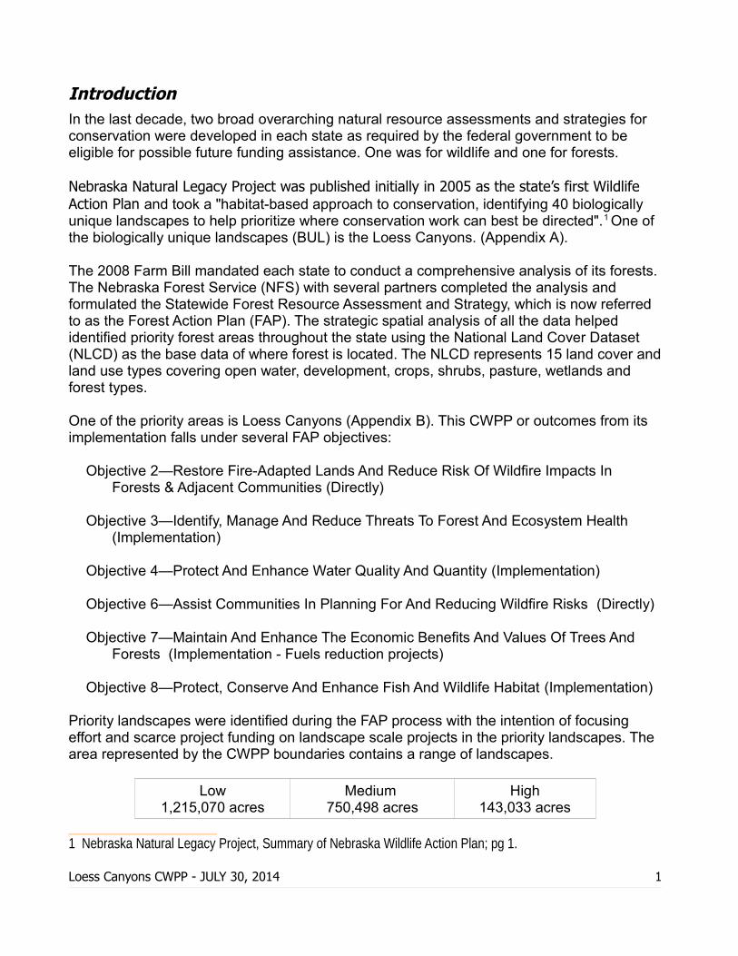
IntroductionIn the last decade, two broad overarching natural resource assessments and strategies for conservation were developed in each state as required by the federal government to be eligible for possible future funding assistance. One was for wildlife and one for forests.
Nebraska Natural Legacy Project was published initially in 2005 as the state’s first Wildlife Action Plan and took a "habitat-based approach to conservation, identifying 40 biologically unique landscapes to help prioritize where conservation work can best be directed".1
One of the biologically unique landscapes (BUL) is the Loess Canyons. (Appendix A).
The 2008 Farm Bill mandated each state to conduct a comprehensive analysis of its forests. The Nebraska Forest Service (NFS) with several partners completed the analysis and formulated the Statewide Forest Resource Assessment and Strategy, which is now referred to as the Forest Action Plan (FAP). The strategic spatial analysis of all the data helped identified priority forest areas throughout the state using the National Land Cover Dataset (NLCD) as the base data of where forest is located. The NLCD represents 15 land cover andland use types covering open water, development, crops, shrubs, pasture, wetlands and forest types.
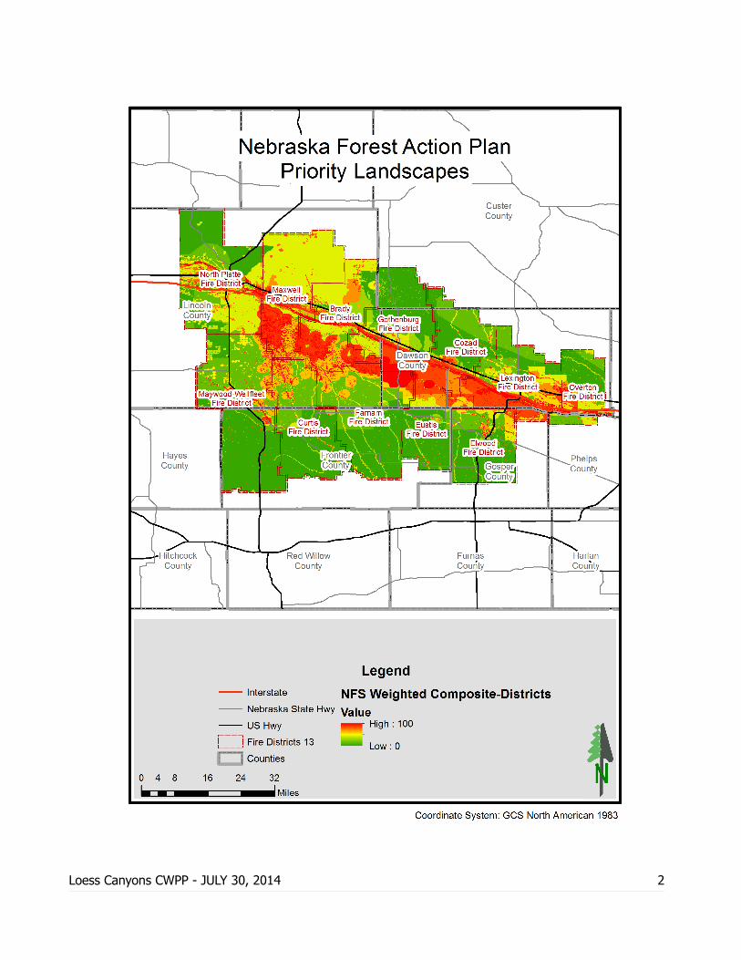
One of the priority areas is Loess Canyons (Appendix B). This CWPP or outcomes from its implementation falls under several FAP objectives:
Objective 2—Restore Fire-Adapted Lands And Reduce Risk Of Wildfire Impacts In Forests & Adjacent Communities (Directly)
Objective 3—Identify, Manage And Reduce Threats To Forest And Ecosystem Health (Implementation)
Objective 4—Protect And Enhance Water Quality And Quantity (Implementation)
Objective 6—Assist Communities In Planning For And Reducing Wildfire Risks (Directly)
Objective 7—Maintain And Enhance The Economic Benefits And Values Of Trees And Forests (Implementation - Fuels reduction projects)
Objective 8—Protect, Conserve And Enhance Fish And Wildlife Habitat (Implementation)
Priority landscapes were identified during the FAP process with the intention of focusing effort and scarce project funding on landscape scale projects in the priority landscapes. The area represented by the CWPP boundaries contains a range of landscapes.
Low1,215,070 acres
Medium 750,498 acres
High143,033 acres
1 Nebraska Natural Legacy Project, Summary of Nebraska Wildlife Action Plan; pg 1.
Loess Canyons CWPP - JULY 30, 2014 1
Loess Canyons CWPP - JULY 30, 2014 2
ProcessThe Loess Canyons CWPP area was defined using fire districts that encompassed the Loess Canyons BUL and priority forest area. Each fire district will be considered a wildland urban interface (WUI) for planning purposes as each contains one of more villages, cities, unincorporated communities, and scattered farmsteads and infrastructure. The CWPP area as a whole has encroaching Eastern redcedar across the range lands, canyons and riparian forest along the Platte and its tributaries to the point of changing the ecosystems and fire intensity.
Collaborators were provided the opportunity to provide input via personal communication and a web survey covering fire district equipment and personnel, infrastructure, access and fuels concerns. Emergency Managers, Municipal and County officials, the Natural ResourceDistricts and NPPD were asked what if any concerns they had and to rank possible programs in fire prevention, suppression and education areas. The survey is found in Appendix C. The narrative that follows includes the concerns and information provided by allpartners.
Aerial ViewsVisual assessments of each district was made using United States Department of Agriculture(USDA) National Agriculture Imagery Program (NAIP) 2012 imagery. The one-meter ground sample distance of the imagery allows some analysis of fuel concentrations and trouble spots in areas not easily accessible on the ground in a time efficient manner. An aerial view map is in each fire district's map section displaying the NAIP imagery.
Native Vegetation DataNative Vegetation of Nebraska was gathered from the University of Nebraska - Lincoln School of Natural Resources. The layer is described in it's metadata as "data from a mylar 1:1,000,000 map published by CSD in 1993. Used to determine the number of acres of eachbroad vegetation type across the state. Considerable effort was required to geocode over 1000 polygons to properly represent the map." This broad view assisted in defining Loess Canyons and other landforms with the absence of elevation data in the gentle rolling topography of the planning area. The data layer is referred to in each district's write-up with a map for the entire CWPP showing the generalized Native Vegetation as a map in Appendix D.
LANDFIRE Data regarding fuel models was acquired from LANDFIRE. LANDFIRE (Landscape Fire and Resource Management Planning Tools) contains 20 national geospatial layers of data that support regional and landscape scale projects including hazardous fuel reduction and ecological conservation activities. and initiatives set forth in the Healthy Forests Restoration Act and National Fire Plan, such as Community Wildfire Protection Plans.
Loess Canyons CWPP - JULY 30, 2014 3
Each District is overlayed with fire behavior fuel models to assist in prioritizing hazardous fuels projects. Fuel models used are the 40 Scott and Burgan Fire Behavior Fuel Models (40FBFMs) which are model dynamic predictors of fire behavior across more prairie type fuels than those that were defined by the original 13 fire models in 1982. More information on the fuel models can be found in the USDA Forest Service Rocky Mountain Research Station General Technical Report RMRS-GTR-153.
The data layers are scientifically based and the process was thoroughly ground truthed to develop this nationwide resource for planning. The NFS agrees with the boundaries betweenfuel types, but questions the accuracy of some of the underlying fuel descriptions in the state, i.e. the fuel may be more dense than what LANDFIRE defines as was presented in theoriginal publication of data. This 40FBFMs layer was published March 31, 2013 and appears to have improved in that area.
The NLCD and LANDFIRE layers are in raster format, with each cell in the raster representing 0.222 acres (900 sq meters) which provides avenues for spatial analysis. Should the partners decide, a more detailed spatial analysis with LANDFIRE and other data could be completed in plan revisions.
Appendix E contains a synopsis of the 40FBFMs and the break down of acres and percent of each fuel model in each fire district. A fire behavior fuel model map is in each fire district's map section displaying the 40FBFMs in that district.
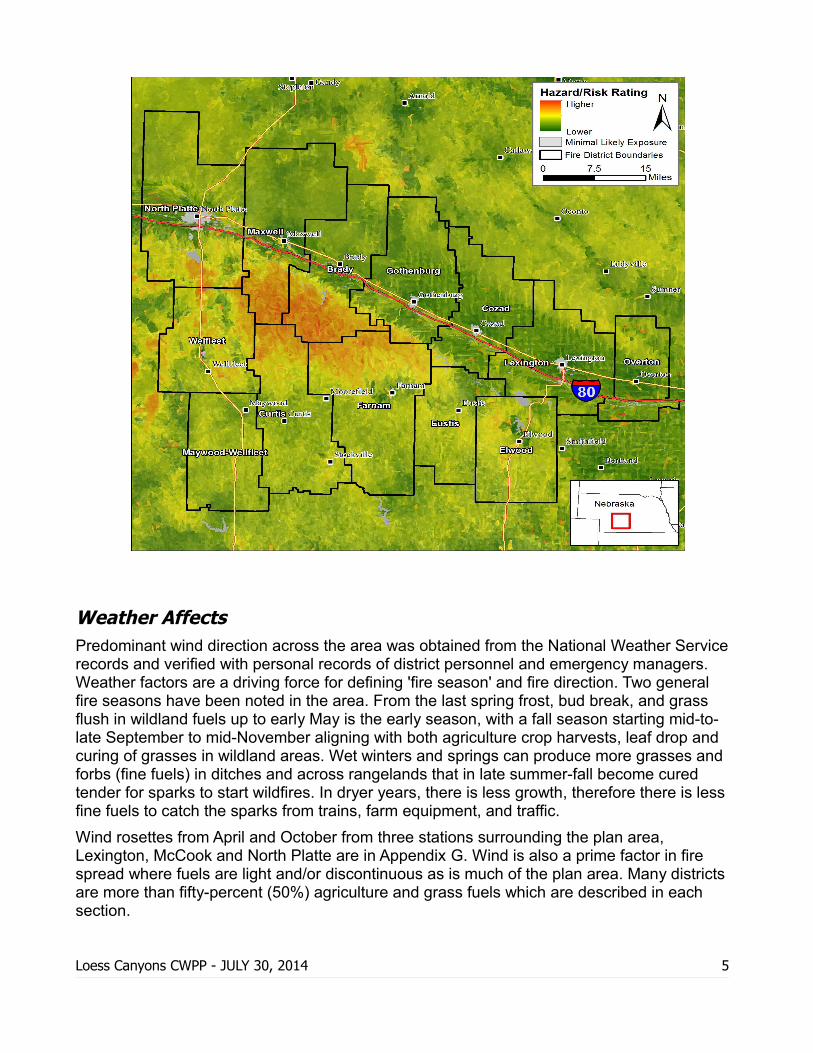
No-HARM
The National Hazard and Risk Model (No-HARM) was developed by Anchor Point Group, Wildland Fire Solutions of Boulder, Colorado. It is a geospatial model developed to meet the need for accurate information on the threat of wildfire to structures in the US. Using the science of fire and nationally available data, they created FireShedsTM and incorporated fire behavior modeling for both wildland and the urban interface, historic wildfire disturbance context, suppression factors, ignition probability, parcel and road density, and distance to fire stations, with adjustments for elevation and aspect. The output is a map grid displaying a combination hazard risk rating from low to extreme.
While the data layers were not made available to run the model ourselves, maps displaying the No-HARM ratings for the plan area were made available to us. Future updates to this plan could make use of the No-HARM model using localized, updated information, drilling down to refine the inputs and results for either a specific fire district, mutual aid district, county or the state. More information on the model is found in Appendix F. A NoHARM map is in each fire district's map section displaying the hazard risk rating in that district. Maywood-Wellfleet Fire District is shown in two maps for better viewing resolution.
Loess Canyons CWPP - JULY 30, 2014 4
Weather AffectsPredominant wind direction across the area was obtained from the National Weather Servicerecords and verified with personal records of district personnel and emergency managers. Weather factors are a driving force for defining 'fire season' and fire direction. Two general fire seasons have been noted in the area. From the last spring frost, bud break, and grass flush in wildland fuels up to early May is the early season, with a fall season starting mid-to-late September to mid-November aligning with both agriculture crop harvests, leaf drop and curing of grasses in wildland areas. Wet winters and springs can produce more grasses and forbs (fine fuels) in ditches and across rangelands that in late summer-fall become cured tender for sparks to start wildfires. In dryer years, there is less growth, therefore there is lessfine fuels to catch the sparks from trains, farm equipment, and traffic.
Wind rosettes from April and October from three stations surrounding the plan area, Lexington, McCook and North Platte are in Appendix G. Wind is also a prime factor in fire spread where fuels are light and/or discontinuous as is much of the plan area. Many districtsare more than fifty-percent (50%) agriculture and grass fuels which are described in each section.
Loess Canyons CWPP - JULY 30, 2014 5
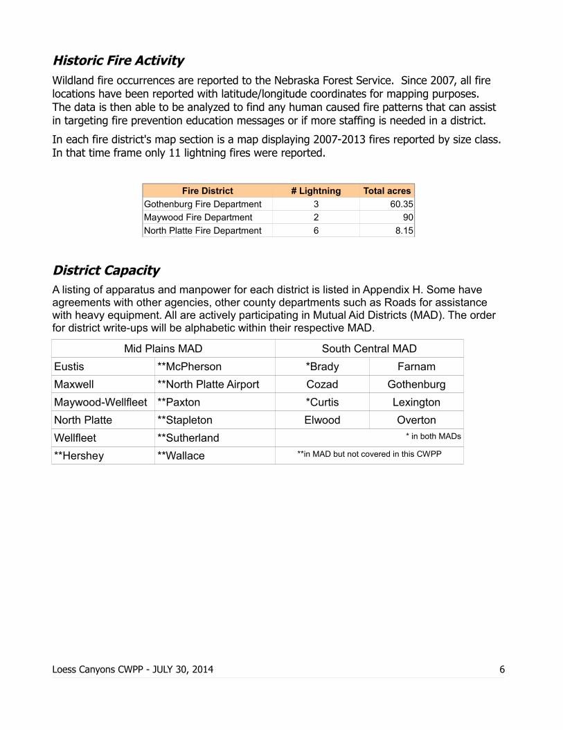
Historic Fire ActivityWildland fire occurrences are reported to the Nebraska Forest Service. Since 2007, all fire locations have been reported with latitude/longitude coordinates for mapping purposes. The data is then able to be analyzed to find any human caused fire patterns that can assist in targeting fire prevention education messages or if more staffing is needed in a district.
In each fire district's map section is a map displaying 2007-2013 fires reported by size class.In that time frame only 11 lightning fires were reported.
Fire District # Lightning Total acres
Gothenburg Fire Department 3 60.35
Maywood Fire Department 2 90
North Platte Fire Department 6 8.15
District CapacityA listing of apparatus and manpower for each district is listed in Appendix H. Some have agreements with other agencies, other county departments such as Roads for assistance with heavy equipment. All are actively participating in Mutual Aid Districts (MAD). The order for district write-ups will be alphabetic within their respective MAD.
Mid Plains MAD South Central MAD
Eustis **McPherson *Brady Farnam
Maxwell **North Platte Airport Cozad Gothenburg
Maywood-Wellfleet **Paxton *Curtis Lexington
North Platte **Stapleton Elwood Overton
Wellfleet **Sutherland * in both MADs
**Hershey **Wallace **in MAD but not covered in this CWPP
Loess Canyons CWPP - JULY 30, 2014 6
WUI Areas - Mid Plains MAD
Eustis Fire District
110,389 acres
The Village of Eustis (pop. 401) sits amongst Loess Canyons, with the northeast portion of the district primarily in agriculture crops and the rest of the district having scattered crops in and among the Loess Canyons and flats.
There is very little forested area in the district, mostly in riparian areas along Plum Creek and the TriCounty Canal system in the north and Muddy Creek in the south portion of the district. Given that the forest component on the district is in small patches, therefore it is unlikely that the forest component would carry a fire to an extreme.
There are some bridges within the district that the carrying capacity is at or below the GVWRof a loaded water tender.
Forested acres according to the NLCD is 2,221 in the district.
Fuel Models
Primary FBFM40s are NB3 at 34%, GS2 at 32%, and GR2 at 27% leaving 13 other fuel models at 2.1% or less (6.6% total). TL3 which covers the Eastern red cedar component is just 0.03%.
NB3 Agricultural field, maintained in nonburnable condition.GS2 Shrubs are 1 to 3 feet high, moderate grass load. Spread rate high; flame length moderate.GR2 Moderately coarse continuous grass, average depth about 1 foot. Spread rate high; flame length moderate.TL3 Moderate load conifer litter. Spread rate very low; flame length low.
Loess Canyons CWPP - JULY 30, 2014 7

Maxwell Fire District
199.093 acres
There are three distinct zones of vegetation in the district. The northern zone is Sand Hills mixed-grass Prairie, which contains scattered trees, windbreaks and woodlots, but no large contiguous stand of forest. The central zone of agriculture crop fields including the Platte River Riparian Deciduous Forest, the Village of Maxwell (pop. 312) and Marantha Bible Camp. The south zone is Loess Canyons Mixed-grass Prairie with an abundance of encroaching Eastern redcedar on some ridgetops, but mainly on north and east facing canyon slopes.
The north and south zones have less maintained roads for access than the central zone.
Forested acres according to the NLCD is 11,640 in the district.
Fuel Models
Primary FBFM40s are GR1 at 45% and GR2 at 28.5%, leaving 17 other fuel models at 7.7% or less (26.2% total). TU1 which is the Platte River Riparian is 2.6%; TL3 which covers the Eastern red cedar component is just 4.2%.
GR1 Grass is short, patchy, and possibly heavily grazed. Spread rate moderate; flame length low.GR2 Moderately coarse continuous grass, average depth about 1 foot. Spread rate high; flame length moderate.TU1 Fuelbed is low load of grass and/or shrub with litter. Spread rate low; flame length low.TL3 Moderate load conifer litter. Spread rate very low; flame length low.
Loess Canyons CWPP - JULY 30, 2014 8
Maywood - Wellfleet Fire District
286,127 acres
The Villages of Maywood (pop. 261) and Wellfleet (pop. 78) are located in the central portion of the district along Medicine Creek. Wellfleet is situated in a finger of agriculture crop ground with more defined Loess Canyons northeast of town and south of Medicine Creek. More Loess Canyons are again the primary topography along the eastern edge of thedistrict with the majority of the district being minor canyon topography.
The forest resource is mostly in the northeast corner and central third of the district, including riparian stringers along Medicine, North and South Brushy Creeks. The southern third is more a mix of Loess Canyons, broad ridges and flats large enough for some agriculture fields and crops.
Forested acres according to the NLCD is 7,006 in the district.
Fuel Models
Primary FBFM40s are GR2 at 67%, NB3 at 21.6% leaving 15 other fuel models at 3.7% or less (10.7% total). TU1 which is the riparian stringers is 0.47%; TL3 which covers the Eastern red cedar component is just 0.59%.
GR2 Moderately coarse continuous grass, average depth about 1 foot. Spread rate high; flame length moderate.NB3 Agricultural field, maintained in nonburnable condition.TU1 Fuelbed is low load of grass and/or shrub with litter. Spread rate low; flame length low.TL3 Moderate load conifer litter. Spread rate very low; flame length low.
Loess Canyons CWPP - JULY 30, 2014 9
North Platte Fire District
240,669 acres
The district is divided in nearly thirds with the north third in the Sand Hills Mixed-grass Prairie, middle third agriculture crops, Riparian Deciduous Forest and the Platte River, and the southern third some some agriculture crops, Sand Hills Mixed-grass Prairie, Sand Hills Borders Mixed-grass Prairie, and Loess Mixed-grass Prairie.
North Platte (pop. 24,733) is situated between the North Platte and South Platte River channels and associated riparian forest. There are three (3) subdivisions in the district that are of concern in the open prairie/wildland interface north of North Platte: Calvary Hills, Hillcrest Estates, and Weaver Heights. All pose issues in terms of limited access and water supply being readily available/ As in most fires outside the city limits water shuttles would be required and the concentrations of homes compounds that water need in these areas. Water shuttles may utilize stock tanks in some areas of the district.
Lake Maloney is just south of the central agriculture zone along Highway 83. It was built in 1973 to regulate water flow for the North Platte Hyrdro facility which is north of the lake andin the agriculture crop zone. On the west side of Maloney are lake shore homes, golf course,and a state recreation area, with more lake shore homes and two subdivisions on the east side.
Forested acres according to the NLCD is 9,780 in the district.
Fuel Models
Primary FBFM40s are GR2 at 49.6%, GR1 at 21.4%, and NB3 at 14%, leaving 15 other fuel models at 4.7% or less (15% total). TU1 which is the Platte River Riparian is 2.8%; TL3 which covers the Eastern red cedar component is just 0.19%.
GR2 Moderately coarse continuous grass, average depth about 1 foot. Spread rate high; flame length moderate.GR1 Grass is short, patchy, and possibly heavily grazed. Spread rate moderate; flame length low.NB3 Agricultural field, maintained in nonburnable condition.TU1 Fuelbed is low load of grass and/or shrub with litter. Spread rate low; flame length low.TL3 Moderate load conifer litter. Spread rate very low; flame length low.
Loess Canyons CWPP - JULY 30, 2014 10
WUI Areas - South Central MAD
Brady Fire District167,166 acres
The Village of Brady (pop. 428) sits in the Platte River valley on the fringe of Platter River Ripairan forest. Under certain temperature, wind and humidy conditions fire could enter the village from the Platte River.
At higher risk are homes tucked in along the shores of Jeffrey Reservoir as well as scattered homesteads in the southern part of the district with encoraching Eastern redcedar, which have limited access. There are areas within the district that water is a minimum of a 10 mile one-way shuttle. Canals are another issue for access as the weight limits on some bridges over the canals are near the GVWR of water tenders.
Looking at the aerial view of the district and Native Vegetation there are three distinct zones. Platter River Valley, north of the valley there is Sand Hills and Sand Hill Borders mixed grass prairie which has some hills and valleys mixed with some agriculture crop land, and south of the Platte River Valley which is Loess Mixed-grass Prairie.
Forested acres according to the NLCD is 8,070 in the district.
Fuel Models
Primary FBFM40s are GR2 at 33.3%, GR1 at 24.5%, NB3 at 13.9%, and GS2 is 12% leaving15 other fuel models at 4.1% or less (16.3% total). TU1 which is the Platte River Riparian is 3.2%; TL3 which covers the Eastern red cedar component is just 4.1%.
GR2 Moderately coarse continuous grass, average depth about 1 foot. Spread rate high; flame length moderate.GR1 Grass is short, patchy, and possibly heavily grazed. Spread rate moderate; flame length low.NB3 Agricultural field, maintained in nonburnable condition.GS2 Shrubs are 1 to 3 feet high, moderate grass load. Spread rate high; flame length moderate.TU1 Fuelbed is low load of grass and/or shrub with litter. Spread rate low; flame length low.TL3 Moderate load conifer litter. Spread rate very low; flame length low.
While documented prevailing winds in the area would be NW not giving fire much of a start to rip through housing on the east side of Jeffrey Lake, during certain weather patterns up and down canyon winds through the abnormal level of cedar fuels could present an issue.
Loess Canyons CWPP - JULY 30, 2014 11
Cozad Fire District
138,730 acres
City of Cozad (pop. 3,977) is surrounded by agriculture fields and irrigation canals. There is a low probability of a wildfire entering town from the nearest wildland fuel area, Platte River riparian forest south of Interstate 80. The aerial photo shows four (4) distinct fuel areas that could be describe as: City of Cozad; Central agriculture; Platte River and flood plain; North and South rangelands.
The riparian forest along the Platte River is the largest contiguous area of wildland fuels. A fire within the Platte riparian corridor would unlikely cause smoke issues for the Interstate except in extreme weather event since the prevailing wind is almost parallel with the riaprianforest/interstate corridor.
Tributaries, streams and wooded waterways are generally narrow long stringers with control of any fire burning in them dependent on the state of adjacent crop land, i.e. crop rotation, season, irrigated or dryland. Many canals also bi-sect the Central Agriculture area.
Rangeland in the north end of the District has sparse wooded areas and any wildfire would mainly be in crops or crop residue and controlled by the wind. Water limitations in the north end may hinder initial response.
The area of highest concern is the rangeland on the southern end of the District where the Platte River flood plain gives way to the Loess Canyons. Midway Lake snakes along 7 miles of main channel with side channels for another 10 miles creating areas with limited ingress/egress. The north side of Midway Lake has Camp Comeca and the high density of homes in the Cedar Point area are of concern in the event of a wildfire with limited ingress and egress.
Current fire district staff know of some bridges that need to be avoided during response, however there is a study underway to document road infrastructure, such as bridges, that may impeed fire apparatus during initial or extended attack.
Forested acres according to the NLCD is 4,922 in the district.
Fuel Models
Primary FBFM40s are NB3 at 50.3% and GR2 at 28% leaving 16 other fuel models at 6% or less (21.6% total). TU1 which is the Platte River Riparian is 3.1%; TL3 which covers the Eastern red cedar component is just .15%.
NB3 Agricultural field, maintained in nonburnable condition.GR2 Moderately coarse continuous grass, average depth about 1 foot. Spread rate high; flame length moderate.TU1 Fuelbed is low load of grass and/or shrub with litter. Spread rate low; flame length low.TL3 Moderate load conifer litter. Spread rate very low; flame length low.
Camp Comeca and Cedar Point are primariy in GR2, GS2, and some TU1.
GS2 Shrubs are 1 to 3 feet high, moderate grass load. Spread rate high; flame length moderate.
Loess Canyons CWPP - JULY 30, 2014 12
Curtis Fire District
179,454 acres
There are three villages within the district; Curtis (pop. 939), Moorefield (pop. 32) and the County Seat Stockville (pop. 25). Curtis and Stockville are situated along waterways with stringers of riparian forest and Loess Mixed-grass Prairie adjacent. Moorefield does not have the riparian stringer.
Loess Canyons in the north portion of the district are more prevalent lending to very little agriculture crop ground. The canyons are gradually further apart east and moving south in the district to Curtis and further, leaving more room for agriculture crop ground.
The northern Loess Canyons have a higher concentration of the encroaching Eastern redcedar on most ridges and into canyon sides. Otherwise, there is very little contiguous forested areas of any depth/width, most of the forest is in riparian stringers. The concentration of cedar is predominantly on ridgetops and north facing slopes of side canyons running east-west.
Forested acres according to the NLCD is 4,033 in the district.
Fuel Models
Primary FBFM40s are GR2 at 47%, NB3 at 24% and GS2 at 20.7%, leaving 14 other fuel models at 2% or less (8% total). TU1 which is the Riparian Forests is 1.3%; TL3 which covers the Eastern red cedar component is just 0.95%.
GR2 Moderately coarse continuous grass, average depth about 1 foot. Spread rate high; flame length moderate.NB3 Agricultural field, maintained in nonburnable condition.GS2 Shrubs are 1 to 3 feet high, moderate grass load. Spread rate high; flame length moderate.TU1 Fuelbed is low load of grass and/or shrub with litter. Spread rate low; flame length low.TL3 Moderate load conifer litter. Spread rate very low; flame length low.
Loess Canyons CWPP - JULY 30, 2014 13
Elwood Fire District
137,039 acres
The Village of Elwood (pop. 707) is in one of the flatter areas of the county at the south end of Elwood Reservoir. The reservoir was formed in the late 1970s to hold water for the irrigation canal system. At full pool it is 1,300 surface acres. Agricultural crop ground is immediately adjacent to the village of Elwwood, which is surrounded by Loess Canyons. There are three other ares of concentrated agriculture crop fields bisected by more canyons.
Many of the canyons, especially south of Highway 23, have nearly vertical sides and very and few roads bisecting them so access is very limited. This also means the canyons are isolated from water sources. There are also bridges scattered throughout the district that have carrying capacity of near or less than the GVWR of loaded water tenders.
Property owners have been keeping an upper hand on invasive wildland fuels, though there are some areas of encroaching Eastern redcedar in those steep canyons that should not be entered during a fire.
Most forested area is on the shores of Elwood Reservoir and riparian forest along Plum Creek, with some isolated pockets on ridge tops and the canyon sides east of Elwood. Thereis no distinction of tree density differences on north/east slope aspects versus south/west as was evident in other districts.
Johnson Lake is bisected by the north boundary of the district. The lake front is heavily developed with cabins and has limited egress.
Forested acres according to the NLCD is 4,671 in the district.
Fuel Models
Primary FBFM40s are GR2 at 32.6%, NB3 at 30% and GS2 at 27%, leaving 14 other fuel models at 2.6% or less (9.8% total). TU1 which is the Riparian Forests is 2.6%; TL3 which covers the Eastern red cedar component is just 0.02%.
GR2 Moderately coarse continuous grass, average depth about 1 foot. Spread rate high; flame length moderate.NB3 Agricultural field, maintained in nonburnable condition.GS2 Shrubs are 1 to 3 feet high, moderate grass load. Spread rate high; flame length moderate.TU1 Fuelbed is low load of grass and/or shrub with litter. Spread rate low; flame length low.TL3 Moderate load conifer litter. Spread rate very low; flame length low.
Loess Canyons CWPP - JULY 30, 2014 14
Farnam Fire District
224,095 acres
Immediately adjacent to Farnam (pop. 171) is agricultural crop ground, with pronounced Loess Canyons to the north and less concentrated canyon formations in the south. That is the ridge tops are broader and fissures fewer per area south of Highway 23, with more agriculture crop ground available.
The largest concentration of forest is the riparian forest along Medicine Creek in the southwest portion of the district. Deer, Dry, East Fork Dry, North Plum and West Muddy Creeks do not have a similar riparian forest.
North and west of Farnam the range land is a dangerous area for firefighters due to the terrain, distance to water and large volume of Eastern redcedar. While some landowners conduct control burns, there is still many areas where a fire could affect or take out several residences.
Other problems to initial or extended attack is that the terrain creates one-way access for some pastures, and there are some bridges and areas where soils won't support the weight of apparatus such as the semi-truck tender when full.
Forested acres according to the NLCD is 2,417 in the district.
Fuel Models
Primary FBFM40s are GS2 at 40.7%, GR2 at 27.5%, and NB3 at 24%, leaving 13 other fuel models at 2.7% or less (7.6% total). TU1 which is the Riparian Forests is 0.55%; TL3 which covers the Eastern red cedar component is just 0.85%.
GS2 Shrubs are 1 to 3 feet high, moderate grass load. Spread rate high; flame length moderate.GR2 Moderately coarse continuous grass, average depth about 1 foot. Spread rate high; flame length moderate.NB3 Agricultural field, maintained in nonburnable condition.TU1 Fuelbed is low load of grass and/or shrub with litter. Spread rate low; flame length low.TL3 Moderate load conifer litter. Spread rate very low; flame length low.
Loess Canyons CWPP - JULY 30, 2014 15
Gothenburg Fire District
170,117 acres
Gothenburg (pop. 3,574) and Willow Island (pop. 26) lie along Interstate 80 (I-80) with the Platte River Riparian forest south and agricultural crop land surrounding them. Five agriculture irrigation supply canals run generally parallel to I-80 in the south part of the main agriculture crop zone.
North portion of the district is in Custer County where agriculture crop land is limited due to more Loess Canyon topography. Buffalo Creek runs north-south through the district feeding into the Platte River Channel just east of the district.
The largest concentration of forest is in the Platte River Riparian area. The southwestern tip of the district is an area of dense Loess Canyons just outside the Platte River flood plain. The far west corner of the district is home to Gulch Canyon which contains a dense stringer along the channel and some scattered pockets.
The Native Vegetation layer shows Loess Mixed-grass Prairie, Lowland Tallgrass Prairie, Riparian Deciduous Forest, Sand Hills Borders Mixed-grass Prairie and Sand Hills Mixed-grass Prairie.
Forested acres according to the NLCD is 5,529 in the district.
Fuel Models
Primary FBFM40s are NB3 at 51%, GR2 at 24.7% and GR1 at 10.5%, leaving 15 other fuel models at 4% or less (13.77% total). TU1 which is the Platte River Riparian is 4%; TL3 which covers the Eastern red cedar component is just 0.11%.
NB3 Agricultural field, maintained in nonburnable condition.GR2 Moderately coarse continuous grass, average depth about 1 foot. Spread rate high; flame length moderate.GR1 Grass is short, patchy, and possibly heavily grazed. Spread rate moderate; flame length low.TU1 Fuelbed is low load of grass and/or shrub with litter. Spread rate low; flame length low.TL3 Moderate load conifer litter. Spread rate very low; flame length low.
Loess Canyons CWPP - JULY 30, 2014 16

Lexington Fire District
162,340 acres
The district has a large central zone of agricultural crop ground with the Platte River running thru the south quarter of it, with some Loess Canyons range in the far north and extreme south. The City of Lexington (pop. 10,230) is within the central zone.
Johnson Lake straddles the south border of the district, with a concentration of homes around the shore with limited access. The Platte River riparian forest is the largest contiguous area of trees. Buffalo, French and Spring Creek and a few smaller drainages andcanals having stringers of riparian forest that are not always contiguous.
Forested acres according to the NLCD is 8,794 in the district.
Fuel Models
Primary FBFM40s are NB3 at 55% and GR2 at 27% leaving 16 other fuel models at 4.6% or less (17% total). TU1 which is the Platte River Riparian is 4.5%; TL3 which covers the Eastern red cedar component is just 0.11%.
NB3 Agricultural field, maintained in nonburnable condition.GR2 Moderately coarse continuous grass, average depth about 1 foot. Spread rate high; flame length moderate.TU1 Fuelbed is low load of grass and/or shrub with litter. Spread rate low; flame length low.TL3 Moderate load conifer litter. Spread rate very low; flame length low.
Loess Canyons CWPP - JULY 30, 2014 17
Overton Fire District
93,407 acres
The district is visually mostly agriculture crop ground, and if measured on the NAIP imagery it is indeed 76.6% crop ground. The rest of the district is shallow Loess Canyons of Loess Mixed-grass Prairie. The Village of Overton (pop. 594) is in the largest contiguous area of agriculture crop ground north of the Platte River corridor and southwest of Buffalo Creek.
Most of the forest resource in the district is in the Platte River Riparian Forest, with some stringers along Buffalo and Elm Creeks. The Platte River riparian forest is highly dense and of concern, in spite of its small overall percentage.
Forested acres according to the NLCD is 5,082 in the district.
Fuel Models
Primary FBFM40s are NB3 at 49% and GR2 at 36.6% leaving 17 other fuel models at 4.8% or less (14.3% total). TU1 which is the Platte River Riparian is 4.8%; TL3 which covers the Eastern red cedar component is just 0.13%.
NB3 Agricultural field, maintained in nonburnable condition.GR2 Moderately coarse continuous grass, average depth about 1 foot. Spread rate high; flame length moderate.TU1 Fuelbed is low load of grass and/or shrub with litter. Spread rate low; flame length low.TL3 Moderate load conifer litter. Spread rate very low; flame length low.
Loess Canyons CWPP - JULY 30, 2014 18
Other Factors
Communications Communicating between units can be problematic. Frontier and Lincoln Counties are using UHF systems. Dawson and Gosper Counties are using VHF systems. UHF and VHF systems do not work together, which would be dangerous during any mutual aid call. There is also concern if aerial suppression is needed because air to ground communications is lacking.
MAD Map data/updatesUpdated maps using GIS layers to provide electronic or hand-held access during a responsewould be beneficial. At the very least maps/layers should be updated annually with map books provided to all districts within the mutual aid district.
Layers that should be maintained are:
all infrastructure roads - federal, state, county, township, ranch
railways power substations
pipelines by type water sources by type bridges categorized with carrying capacity
flammable storage: chemicals, fertilizer, anhydrous ammonia, propane, gasoline and diesel
pipeline pumping stations
power lines farmsteads municipal wellheads
tall towers/antennas for air resources
canals hydrants and dry hydrants
overhead water refill access
Much of this can be obtained from county GIS layers or collaborators, but it will also rely on landowners to provide critical information to keep them and fire suppression forces safe.
Loess Canyons CWPP - JULY 30, 2014 19
Action PlanEducation and Involvement of community leaders and landowners will be important to achieve reduced hazard and risk. Under certain weather and fuel conditions fire can be a beneficial tool for removing the overabundant fuels and restoring prairie grassland ecosystems. Some prescribed fire is already occurring in some fire districts.
It is when there are weather extremes of prolonged heat, below average rainfall, low relative humidity, high winds and an unintentional spark from a human source or a dry lightning strike that resources are typically under heightened risk of loss. It is under these circumstances that previously completed proactive steps can reduce the threat for one or many properties and infrastructure.
Individuals can reduce structure ignitability on their home and outbuildings. For example, cedar shake shingles should be replaced with asphalt shingles or metal roofing so firebrandslanding on the roof cannot start the building on fire. New buildings in wooded or dense shrubarea should consider construction techniques that would reduce ignitability from fire brands, or convective and radiant heat as a fire moves past, such as steel, stucco or cement siding. Removing ignitability sources in the buildings' ignition zone is also needed to increase defensible space and possibly provide a safe zone for the landowner or firefighters.
More information on reducing hazard and risk, and definitions of unfamiliar terms used here, can be found at:
• FIREWISE (firewise.org) is a great resource for educational materials in wildfire preparedness.
• Nebraska Forest Service has several resources
• for Fire Prevention (http://nfs.unl.edu/fire-prevention)
• Wildland Fire Protection (http://nfs.unl.edu/publications.asp#fireprotection)
• Living With Fire, A Homeowner's Guide (Western Neb. Edition) available (http://nfs.unl.edu/documents/fireprotection/Living%20With%20Fire%20Western%20NE%208x11%20low.pdf).
• Ready, Set, Go (http://www.wildlandfirersg.org/) International Association of Fire Chiefs program for those who live in high risk wildfire areas best prepare themselves and properties against fire threats.
The Interested Parties Survey contained a poll to rank six possible programs that could facilitate portions of this plan. In order of respondents' rankings:
Wildfire Protection ProgramCould include activities such as Smokey Bear school programs, home or farmstead inspections for FIREWISE practices to reduce fire risk and ignitability, and improve defensibility of the home/farmstead.
Loess Canyons CWPP - JULY 30, 2014 20
Hazardous Fuels ProjectsThe harvest and removal of excessive wildland fuels such as encroaching Eastern redcedar and riparian invasive plants. Evacuation routes, ingress and egress may alsoneed treatments to have sufficient width with low density of trees and shrubs.
Restoration Of Fire-Adapted Ecosystems ProgramsThis could include a combination of harvest and prescribed fire to return rangelands to their native grassland or shrub-grassland state.
Wildfire Suppression ProgramAdditional firefighter training for wildland Red Card certification (approved National Wildfire Coordinating Group [NWCG] courses), additional firefighting equipment and firefighter recruitment.
Community Homeowner Wildland Fire Education ProgramThis would likely be FIREWISE educational programs on how to make your home andfarmstead safer from wildland fire threat.
Emergency Preparedness And Communications ProgramThis can include training, equipment and education at many levels, and preparednessplans for evacuation procedures for a fire district, mutual aid district, entire county, orindividual homeowners - trigger points for when, where to go/how to get there, including pets, people and livestock.
Economic ImpactsThe excessive fuel loading in the Loess Canyons areas can affect the local economy in many ways. Currently the fuel loading, especially the Eastern redcedar, is reducing forage resources for cattle and upland game. Less forage reduces the carrying capacity of the pastures and therefore limits herd size of both cattle and deer.
If the cedar is removed by uncontrolled wildfire, other resources are also affected. Intense fires may induce hydrophobic soils, where in steep terrain runoff is significantly accelerated. Loss of all grazing and decreased quality water quality can be long lasting affects for landowners and their livestock and hunting livelihoods.
A proactive approach to reducing hazardous fuel levels can provide jobs and a resource of biomass or other products from the cedar trees. Mechanical removal of encroaching Eastern redcedar will reduce the hazard and risk of intense wildfire, improve grazing capacity, wildlife habitat and increase water amounts reaching the streams, lakes and the water table.Care on canyon sides and slopes is needed so as to reduce potential erosion from both equipment use and less plant root zones holding soil.
Loess Canyons CWPP - JULY 30, 2014 21
Hazardous Fuels Reduction Projects
Landowners or organizations within the NFS FAP Priority Landscapes proposing a project to reduce fuels would be first for assistance grant requests, especially those working in concertwith neighbors providing a contiguous area.
Marantha Bible Camp is ready to start cutting and has manpower but needs assistance for equipment and disposal of the material.
NFS is anticipating that material being removed can be utilized by local artisans or the biomass energy facility at the Nebraska College of Technical Agriculture in Curtis.
Loess Canyons CWPP - JULY 30, 2014 22
Maps of Districts - (separate file)Each district has the following maps
• aerial view• fire incidents• Fire Behavior Fuel Model 40• NoHARM
Appendices - (separate file)
Loess Canyons CWPP - JULY 30, 2014 23