Locator map
2
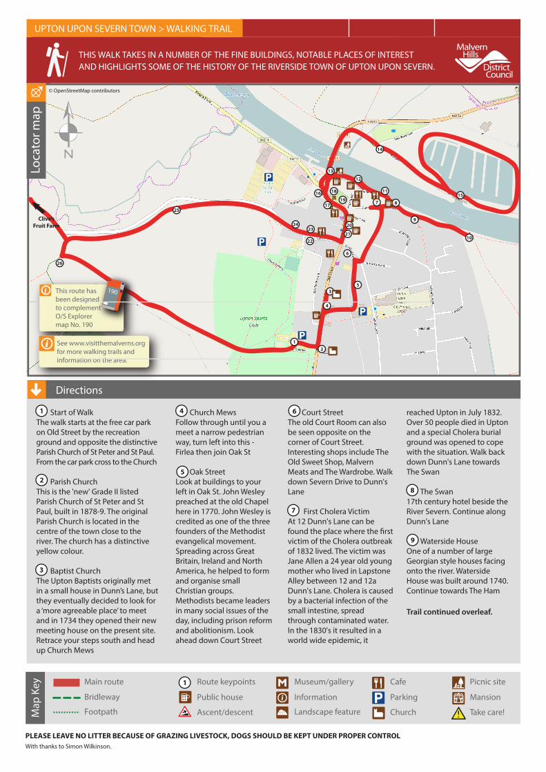
Locator map This route has been designed to complement O/S Explorer map No. 190 190 Start of Walk The walk starts at the free car park on Old Street by the recreation ground and opposite the distinctive Parish Church of St Peter and St Paul. From the car park cross to the Church Parish Church This is the 'new' Grade II listed Parish Church of St Peter and St Paul, built in 1878-9. The original Parish Church is located in the centre of the town close to the river. The church has a distinctive yellow colour. Baptist Church The Upton Baptists originally met in a small house in Dunn’s Lane, but they eventually decided to look for a ‘more agreeable place’ to meet and in 1734 they opened their new meeting house on the present site. Retrace your steps south and head up Church Mews PLEASE LEAVE NO LITTER BECAUSE OF GRAZING LIVESTOCK, DOGS SHOULD BE KEPT UNDER PROPER CONTROL With thanks to Simon Wilkinson. Church Mews Follow through until you a meet a narrow pedestrian way, turn left into this - Firlea then join Oak St Oak Street Look at buildings to your left in Oak St. John Wesley preached at the old Chapel here in 1770. John Wesley is credited as one of the three founders of the Methodist evangelical movement. Spreading across Great Britain, Ireland and North America, he helped to form and organise small Christian groups. Methodists became leaders in many social issues of the day, including prison reform and abolitionism. Look ahead down Court Street Court Street The old Court Room can also be seen opposite on the corner of Court Street. Interesting shops include The Old Sweet Shop, Malvern Meats and The Wardrobe. Walk down Severn Drive to Dunn's Lane First Cholera Victim At 12 Dunn's Lane can be found the place where the first victim of the Cholera outbreak of 1832 lived. The victim was Jane Allen a 24 year old young mother who lived in Lapstone Alley between 12 and 12a Dunn's Lane. Cholera is caused by a bacterial infection of the small intestine, spread through contaminated water. In the 1830's it resulted in a world wide epidemic, it reached Upton in July 1832. Over 50 people died in Upton and a special Cholera burial ground was opened to cope with the situation. Walk back down Dunn's Lane towards The Swan The Swan 17th century hotel beside the River Severn. Continue along Dunn's Lane Waterside House One of a number of large Georgian style houses facing onto the river. Waterside House was built around 1740. Continue towards The Ham Trail continued overleaf. THIS WALK TAKES IN A NUMBER OF THE FINE BUILDINGS, NOTABLE PLACES OF INTEREST AND HIGHLIGHTS SOME OF THE HISTORY OF THE RIVERSIDE TOWN OF UPTON UPON SEVERN. Directions UPTON UPON SEVERN TOWN > WALKING TRAIL 3 MILES – CIRCULAR WALK TIME: 2.5HRS ABILITY: EASY See www.visitthemalverns.org for more walking trails and information on the area. 1 3 4 5 6 7 8 Main route Bridleway Footpath Route keypoints Museum/gallery Cafe Public house Ascent/descent Information Landscape feature Parking Church Picnic site Mansion Take care! Map Key 2 1 © OpenStreetMap contributors 2 1 9 2 3 4 5 6 7 8 9 10 11 12 13 14 15 16 17 18 19 20 21 22 23 24 25 26 Clive’s Fruit Farm
Transcript of Locator map
Loca
tor m
ap
This route has been designed to complement O/S Explorer map No. 190
190
Start of Walk The walk starts at the free car park on Old Street by the recreation ground and opposite the distinctive Parish Church of St Peter and St Paul. From the car park cross to the Church
Parish Church This is the 'new' Grade II listed Parish Church of St Peter and St Paul, built in 1878-9. The original Parish Church is located in the centre of the town close to the river. The church has a distinctive yellow colour.
Baptist ChurchThe Upton Baptists originally met in a small house in Dunn’s Lane, but they eventually decided to look for a ‘more agreeable place’ to meet and in 1734 they opened their new meeting house on the present site. Retrace your steps south and head up Church Mews
PLEASE LEAVE NO LITTER BECAUSE OF GRAZING LIVESTOCK, DOGS SHOULD BE KEPT UNDER PROPER CONTROLWith thanks to Simon Wilkinson.
Church MewsFollow through until you a meet a narrow pedestrian way, turn left into this - Firlea then join Oak St
Oak StreetLook at buildings to your left in Oak St. John Wesley preached at the old Chapel here in 1770. John Wesley is credited as one of the three founders of the Methodist evangelical movement. Spreading across Great Britain, Ireland and North America, he helped to form and organise small Christian groups. Methodists became leaders in many social issues of the day, including prison reform and abolitionism. Look ahead down Court Street
Court StreetThe old Court Room can also be seen opposite on the corner of Court Street. Interesting shops include The Old Sweet Shop, Malvern Meats and The Wardrobe. Walk down Severn Drive to Dunn's Lane
First Cholera VictimAt 12 Dunn's Lane can be found the place where the �rst victim of the Cholera outbreak of 1832 lived. The victim was Jane Allen a 24 year old young mother who lived in Lapstone Alley between 12 and 12a Dunn's Lane. Cholera is caused by a bacterial infection of the small intestine, spread through contaminated water. In the 1830's it resulted in a world wide epidemic, it
reached Upton in July 1832. Over 50 people died in Upton and a special Cholera burial ground was opened to cope with the situation. Walk back down Dunn's Lane towards The Swan
The Swan17th century hotel beside the River Severn. Continue along Dunn's Lane
Waterside HouseOne of a number of large Georgian style houses facing onto the river. Waterside House was built around 1740. Continue towards The Ham
Trail continued overleaf.
THIS WALK TAKES IN A NUMBER OF THE FINE BUILDINGS, NOTABLE PLACES OF INTEREST AND HIGHLIGHTS SOME OF THE HISTORY OF THE RIVERSIDE TOWN OF UPTON UPON SEVERN.
Directions
UPTON UPON SEVERN TOWN > WALKING TRAIL 3 MILES – CIRCULAR WALK TIME: 2.5HRS ABILITY: EASY
See www.visitthemalverns.orgfor more walking trails andinformation on the area.
1
3
4
5
6
7
8
Main route
Bridleway
Footpath
Route keypoints Museum/gallery Cafe
Public house
Ascent/descent
Information
Landscape feature
Parking
Church
Picnic site
Mansion
Take care!Map
Key 21
© OpenStreetMap contributors
2
1
9
2
3
4
5
6
7 8
9
10
11
12
13
14
1516
17
18
19
20
2122
2324
25
26
Clive’sFruit Farm
The HamThe Ham covers about 60 hectares of �oodplain. The area is rich in �owers and grasses and is an SSSI. The area is one of the oldest privately owned Lammas meadows in the country. Each summer the grass is allowed to grow until it is cut for hay. Stock is then put out to graze on the meadows from the 1st August, Lammas Day, until the end of the year. At the time of the Napoleonic wars a �ring range was opened on the Ham. The range continued to be used until the 1920's and occasionally in the WWII. The brick targets visible across the area are grade II listed. Return back along Dunn's Lane and into Waterside.
Flood DefencesThe �ood defences were built in 2011 by the Environment Agency. Upton is built on the �oodplain of the Severn and therefore experiences some degree of �ooding every year. November through to February is the peak �ood time, but some of the worst �oods were those of May 1886, August 1912, June and July 2007. Continue along the Waterside.
Site of former Swing BridgeThe former Swing Bridge, which carried the road from the eastern side of the river into Upton.This was replaced in the 1930's by the current bridge just upstream. The River Severn was historically spanned by a wooden bridge and then a stone one. The latter su�ering collapse of one of its arches during the 1852 �ood. It was two years before an iron one replaced it, this having a drawbridge to allow tall vessels through. However it in turn was replaced by a swing bridge the turntable of which is marked by the circular brick feature. Continue along Waterside to cross the bridge.
Bridge over SevernThe steel cantilever bridge has a span of 200 feet. It was opened in 1940. The bridge was the last riveted construction bridge in England. As you leave the bridge turn right onto public path.
View from East WatersideFor many years Upton had limited connections with this side of the river. Continue to walk along the path towards the Marina.
Upton MarinaUpton Marina lies on the 58 miles of navigable Severn stretching from Sharpness to Stourport. The Marina o�ers secure pontoon and bankside moorings for all types of craft with hardstanding storage space and visitor berths. It is also home to a �eet of holiday hire boats. Loop around the marina basin and return back to bridge and into Upton.
Manor HouseUpton has a mixture of Tudor black and white timber buildings and red brick Georgian buildings. The latter re�ect the prosperity brought by the river trade in the 17th century. The building at the end of the row was the manor house until 1170. Behind its Georgian frontage is a timber hall. The building once had three large urns sitting at the top of the wall; these have now been removed, presumably for safety. Walk towards the Old Church Grounds.
Tudor MuseumThe building dates from 1550. The museum covers three �oors and includes a large courtyard garden with a Tudor Knot Garden and herb garden. Open Easter to October Tuesdays to Sundays and Bank Holidays and Sunday afternoons in the Winter.
PepperpotThis was the original Parish Church but is now the home of the Upton Tourist Information and Heritage Centre. Only the lower part of the tower remains from the 14th century Gothic church. The original nave was demolished and the spire pulled down in the mid-18th century when the nave was rebuilt and the spire replaced by the Italianate cupola (the 'Pepperpot') seen today.A memorial to Admiral Sir William Tennant who oversaw the evacuation at Dunkirk in 1940 can bee seen in the Church grounds. He was born in Upton in 1890 and joined the Navy at the age of 15. Walk across the road to Tudor Museum.
Battle of UptonThe Pepperpot is the site of the Battle of Upton in 1651 between Royalists and Roundheads as a preliminary to Oliver Cromwell’s victory over Charles II during the
Civil War. 12,000 men crossed the river here - then, the location of the only bridge across the River Severn between Worcester and Gloucester. The battle was the precursor to the Battle of Worcester. Turn right into the High Street.
High StreetThe High Street has an abundance of interesting buildings and shops. Buildings of note include the White Lion Hotel and amongst the shops The Map Shop, with an extensive range of UK and international walking, road and other specialist maps. Walk down High St.
White Lion HotelThe White Lion Hotel is a 16th century coaching inn, with sections of the building dating to 1510. Reputed to have seen soldiers from both sides of the Civil War enjoying its hospitality prior to the Battle of Worcester. Henry Fielding's 1749 novel "Tom Jones" refers to the hotel as "A house of exceeding good repute". Turn right into New St.
Old Fire StationAn unusual looking building and big enough for just one �re engine. The current working �re station is located beside the A4014 near where the walk starts. Look across New St to Shipps Garage.
Shipps Garage Shipps Garage was a former chapel erected in 1891. The blue plaque marks the height of the �ood on the 22nd July 2007. Continue down to Goom Stool Cottages. Goom Stool CottagesA plaque on the wall shows the site of the former Goom Stool Cottages that were demolished in 1882. The Goom Stool was another name for a ducking stool. Near here was a dirty pool where the ancient r ducking stool stood in which slanderous women were tied and ducked up and down in the water. This was a popular form of punishment in the 16th and 17th centuries. At Upton it would seem the water source was a pond as against the river. Take signed path to Cholera Ground.
Path to Cholera Burial GroundThe path rises over a ridge which runs across the �eld. The ridge is part of the bund put in place in 2011 to block the river �ood waters from reaching the town. Flood gates on lane which together with the bund, form a defence against �ooding of the town. Continue along path or lane to Burial Ground.
Cholera GroundBurials of persons who had died from Cholera took place here from July to August 1832. The decision to create this burial ground was based on the graveyard around the old Parish Church (Pepperpot) being over crowded and the e�ect on the towns people of the constant funerals in the town centre as Cholera took hold. You can continue along the lane a short way to Clive's Fruit Farm or return back via New St and turn right into Old St, or return via footpath along old railway line.
Clive's Fruit Farm A farm with extensive orchards o�ering a range of attractions, including a cafe and farm shop. A good point to take refreshment on your walk. The farm includes a cafe with indoor and outdoor seating, together with a shop selling fresh produce, jams, chutneys, sauces, pies, cheeses and at least 15 di�erent types of beer & cider.
End of Walk
To know more a visit to the Upton Tourist Information and Heritage Centre at the 'Pepperpot' is strongly recommended.
LINK TO WALK MAP
http://my.viewranger.com/route/details/MTIwNTcz
25
26
Directions continued
UPTON UPON SEVERN TOWN > WALKING TRAIL 3 MILES – CIRCULAR WALK TIME: 2.5HRS ABILITY: EASY
10
11
12
13
14
15
16
17
18
19
20
21
22
23
24