Location, Location, Location: Leveraging Interactive Maps and ZIP Code Level Data to Find the...
20
LOCATION, LOCATION, LOCATION: LEVERAGING INTERACTIVE MAPS AND ZIP CODE LEVEL DATA TO FIND THE REMAINING UNINSURED Brett Fried SHADAC, University of Minnesota Minnesota Health Services Research Conference St. Paul, MN March 3, 2015 1 Funded by a grant from the Robert Wood Johnson Foundation’s State Health Reform Assistance Network.
-
Upload
soder145 -
Category
Healthcare
-
view
132 -
download
0
Transcript of Location, Location, Location: Leveraging Interactive Maps and ZIP Code Level Data to Find the...

LOCATION, LOCATION, LOCATION: LEVERAGING INTERACTIVE MAPS AND ZIP CODE
LEVEL DATA TO FIND THE REMAINING UNINSUREDBrett Fried
SHADAC, University of MinnesotaMinnesota Health Services Research Conference
St. Paul, MN
March 3, 2015
1Funded by a grant from the Robert Wood Johnson Foundation’s State Health Reform Assistance Network.

Acknowledgments
Funding for this work is supported by the Robert Wood Johnson Foundation State Reform Assistance Network
• Collaborators:• Elizabeth Lukanen (SHADAC)
• Karen Turner (SHADAC)
2

Research Questions
Can data be used to improve outreach for health insurance marketplaces?
What analytic geography is best?
What are some problems with using data from low level geographies?
Are there strategies to make this data more useful?
3

IS MARKETPLACE ENROLLMENT OVER?
4

Where are we in terms of marketplace enrollment?
• 11.4 million as of Feb. 15
• CBO--24 million by 2017
• 41% of Potentially Eligible (Kaiser)
• People who were easy to enroll have enrolled
5
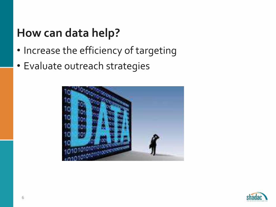
How can data help?
• Increase the efficiency of targeting
• Evaluate outreach strategies
6

WHAT GEOGRAPHY IS BEST
7

What geography is best?
1.What is the purpose of the analysis?
2.Who is the audience for the analysis?
3.What is the target population?
4.How reliable is the data?
5.How timely?
8

Availability of Survey Data - Geography
9
Nation, States, & DC
Congressional Districts
Counties
School Districts
Public Use Microdata Area (PUMA)
Metro & Micro Statistical Areas
Zip Code Tabulation Areas
(ZCTA)
Census Tracts

PUMAs: Public Use MicrodataAreas
10
PUMAs are geographic areas created by the Census Bureau to contain at least 100,000 people and nest within states.
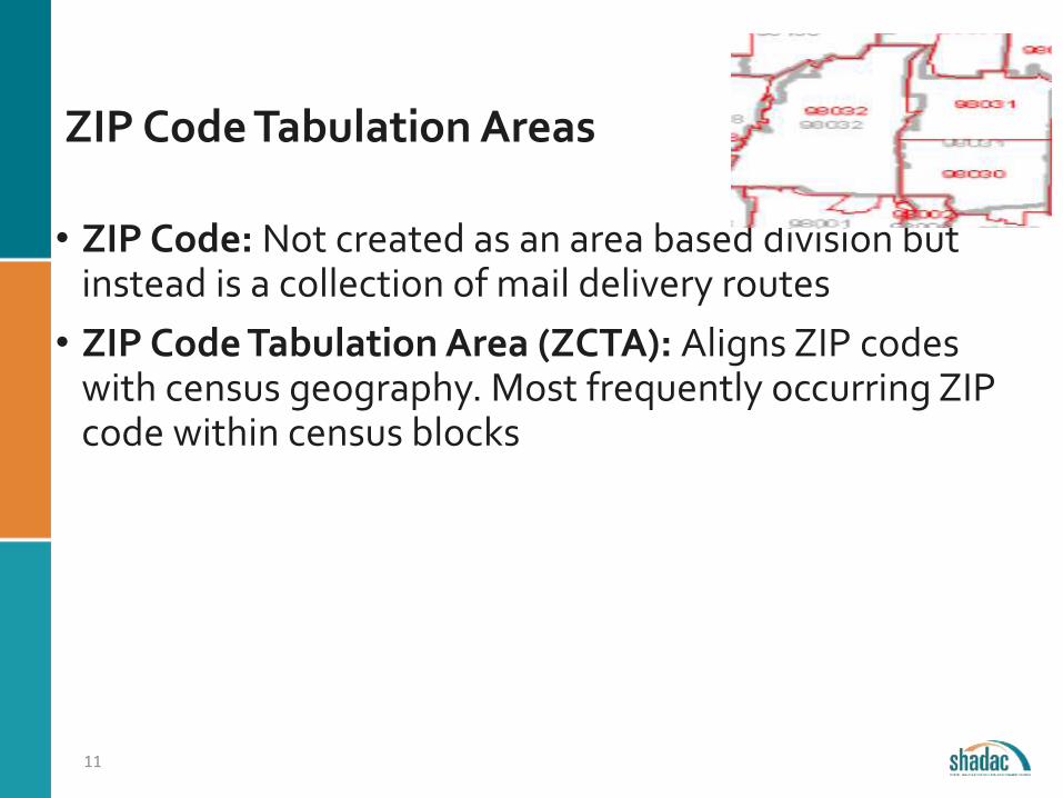
ZIP Code Tabulation Areas
• ZIP Code: Not created as an area based division but instead is a collection of mail delivery routes
• ZIP Code Tabulation Area (ZCTA): Aligns ZIP codes with census geography. Most frequently occurring ZIP code within census blocks
11

Three Census Geographies: Advantages of each
PUMA County ZCTAIncluded in PUMS (can create custom variables from publically available files) X X
Data is timelyX (2014 data--
Sept. 2015)
X (2014 data for all
counties--March 2016)
X (2010-2014 data--
Dec. 2015)
Intuitive geography X
Reliable for full area population X
Neighborhood level estimatesX (
high density areas) X
Nests within other geography X
Data is annual X
12

Using Administrative Data
Combining data• Currently enrolled (administrative data)
• Target Population (census data)
• Remaining Eligible (target pop – enrolled)
Map any administrative data that includes an address(e.g location of application assistors, hospitals, churches)
13

LEVERAGING THE POWER OF MAPS
14
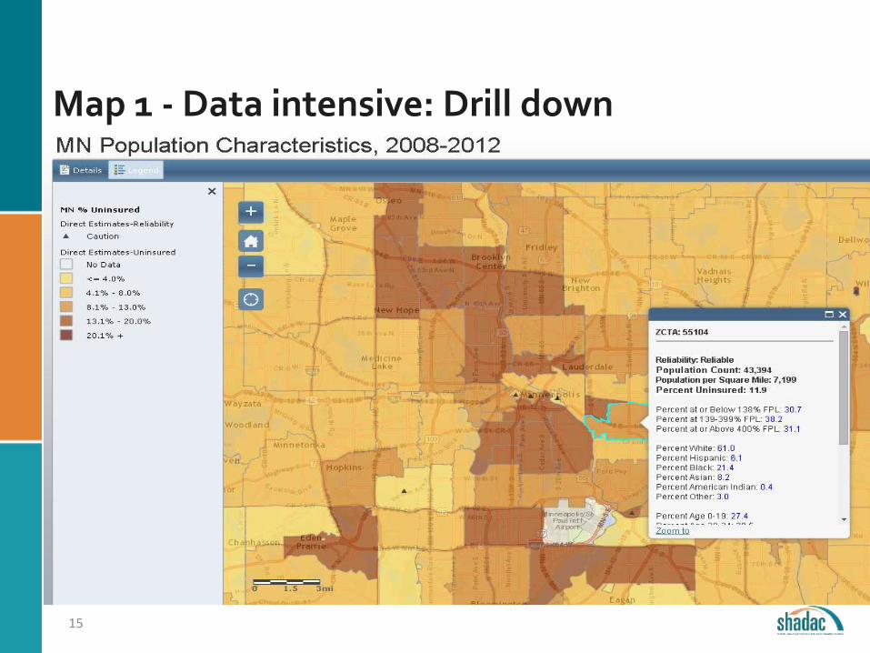
Map 1 - Data intensive: Drill down
15
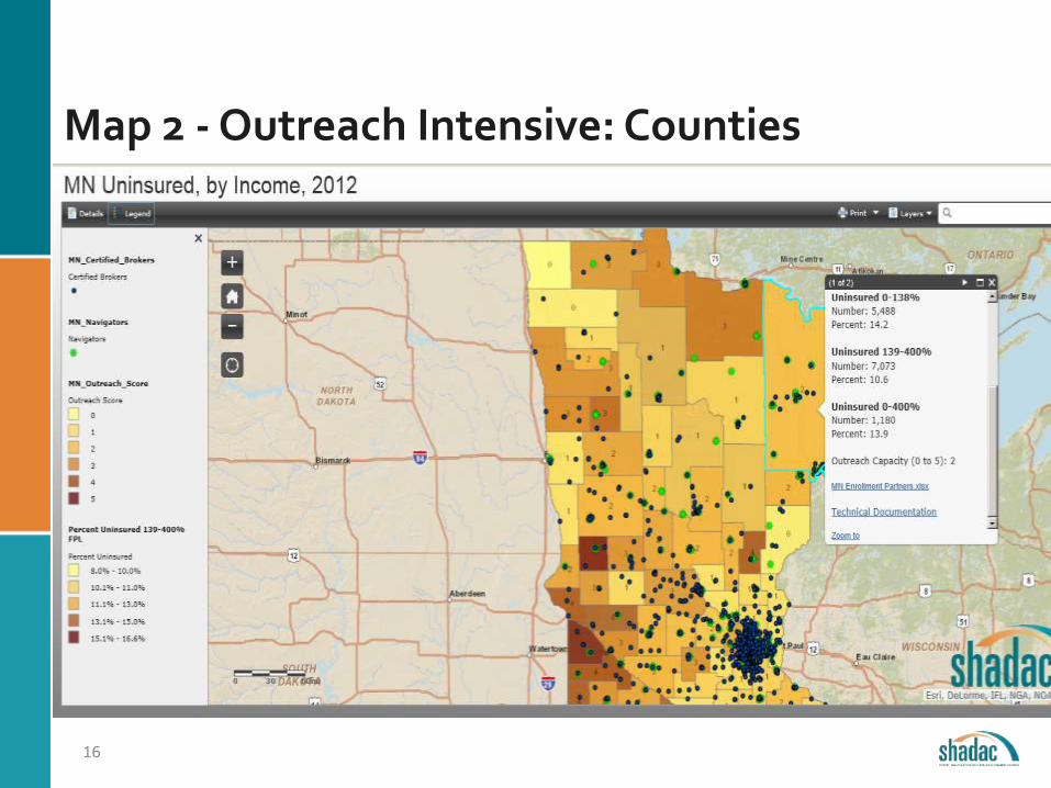
Map 2 - Outreach Intensive: Counties
16
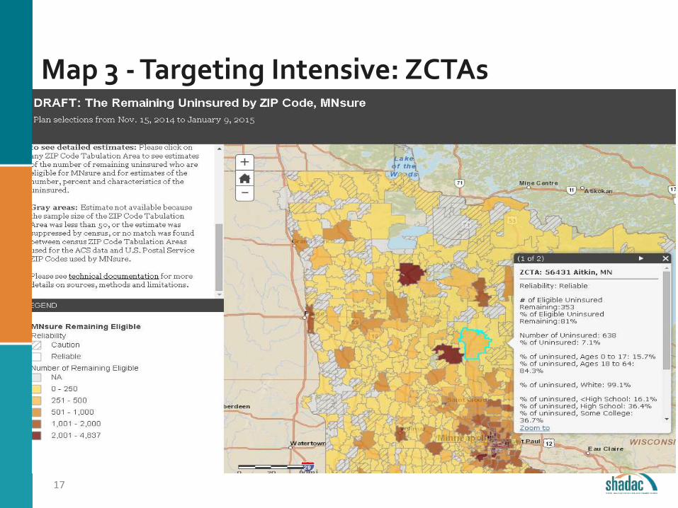
Map 3 - Targeting Intensive: ZCTAs
17
Summary
Choosing the best geography • Availability, timelines and reliability
• The research question
• Audience for the analysis
Advantage of ZIP Code level data• Captures variation between neighborhoods
Disadvantages • Less reliable
• Cannot trend
• Categories and variables are preset by census
• Not timely
18
Summary (2)
Interactive maps and admin data can help
• Interactive maps• Can include anything that has an address
• Can include multiple geographies
• Can include underlying data
• Can include number and percent
• Can be accessed anywhere the internet is available
• Administrative data• Timeliness
• Usefulness
19

www.shadac.org
@shadac
Brett Fried
Senior Research Fellow
612.624.1406
Contact Information
20