LOCATED ADJACENT TO THE ICONIC BATAVIA COAST … South/Batavia... · LOCATED ADJACENT TO THE ICONIC...
14
GOVERNMENT OF WESTERN AUSTRALIA LOCATED ADJACENT TO THE ICONIC BATAVIA COAST MARINA LIES A DEGRADED PARCEL OF VACANT LAND THAT FOR DECADES HAS BEEN AN EYESORE SEPARATING YOUR PICTURESQUE WATERFRONT FROM THE GERALDTON CBD. 1. BACKGROUND The stretch of land is situated between Chapman Road and Foreshore Drive, and Forrest and Bayly Streets. It forms the southern parcel of the overall second stage of the Batavia Coast Marina development project. Although the area’s proximity to the redeveloped Marina and the city centre offered great potential, redevelopment of the land could not be fully progressed as there were constraints from its former use. Previously used as railway marshalling yards, the area required significant remediation to get the site ready for development and beautification. Before this could occur, detailed site investigations were required to determine the level of contamination and the most effective methods of clean-up. Site investigations have taken place over the last 2 years, with neighbouring residents and businesses kept informed of the process and advised of the results. Remediation commenced at the beginning of this year and is mostly completed in the southern parcel. This means that the community is about to see the start of a fantastic new venture that will transform the area so it can realise its true potential. The name of this new destination? STATION SQUARE AT BATAVIA COAST MARINA BUT THAT IS ABOUT TO CHANGE!
Transcript of LOCATED ADJACENT TO THE ICONIC BATAVIA COAST … South/Batavia... · LOCATED ADJACENT TO THE ICONIC...
GOVERNMENT OFWESTERN AUSTRALIA
LOCATED ADJACENT TO THE ICONIC BATAVIA COAST MARINA LIES A DEGRADED PARCEL OF VACANT LAND THAT FOR DECADES HAS BEEN AN EYESORE SEPARATING YOUR PICTURESQUE WATERFRONT FROM THE GERALDTON CBD.
1.
BACKGROUND
The stretch of land is situated between
Chapman Road and Foreshore Drive, and
Forrest and Bayly Streets. It forms the
southern parcel of the overall second stage
of the Batavia Coast Marina development
project.
Although the area’s proximity to the
redeveloped Marina and the city centre
offered great potential, redevelopment of
the land could not be fully progressed as
there were constraints from its former use.
Previously used as railway marshalling
yards, the area required significant
remediation to get the site ready for
development and beautification. Before
this could occur, detailed site investigations
were required to determine the level of
contamination and the most effective
methods of clean-up.
Site investigations have taken place over the
last 2 years, with neighbouring residents
and businesses kept informed of the
process and advised of the results.
Remediation commenced at the beginning
of this year and is mostly completed in
the southern parcel. This means that the
community is about to see the start of a
fantastic new venture that will transform the
area so it can realise its true potential.
The name of this new destination?
STATION SQUARE AT BATAVIA COAST MARINA
BUT THAT IS ABOUT TO CHANGE!
GOVERNMENT OFWESTERN AUSTRALIA
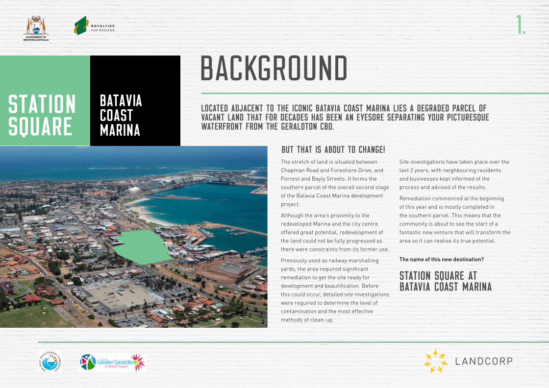
FURTHER REVITALISE GERALDTON’S WATERFRONT TO CREATE TOURISM, RETAIL, COMMERCIAL AND RESIDENTIAL OPPORTUNITIES FOR THE REGION.
CREATE A THRIVING DESTINATION FOR THE COMMUNITY, ONE THAT SEAMLESSLY LINKS THE BATAVIA COAST MARINA WATERFRONT PROMENADE TO THE HEART OF THE CITY, WHILST RESPECTING ITS FORMER HERITAGE.
2.
THE VISION
VISIONThe vision for the Station Square public realm and landscape is framed by:
REFERENCING GERALDTON’S PAST IN ORDER TO SHAPE THE FUTUREThe outcome will deliver a multifunctional, comfortable and grounded place for the visitors and people of Geraldton.
It distills and expresses the multiple inputs from:
1. Rail histories
2. Indigenous histories and stories
3. Microclimatic impacts
4. Coastal systems
5. Community needs, services and functions
6. Limited resources (ie. water and energy)
7. Relationship to proposed and existing built form
Artist’s impression
GOVERNMENT OFWESTERN AUSTRALIA
THE PROJECT PARTNERSA whole-of-Government approach is being applied to the proposed development.
The main partners include the City of Greater Geraldton, the Mid West Development Commission and LandCorp which is contributing towards development costs.
In order to progress initial work including detailed site investigations and subsequent remediation, a $3.86 million funding contribution was made under the Royalties for Regions Mid West Investment Plan.
Station Square at Batavia Coast Marina forms part of the second stage of the overall development of the Batavia Coast Marina. Stage 1 was completed in the early 2000s.
It includes the Marina, the waterfront promenade, the WA Museum Mid West Gallery and cultural hub, landscaped public open space with artwork, tourism and hospitality uses, offices and a very popular permanent residential area.
For Stage 1, LandCorp - as WA’s land and property developer - acted as project manager on behalf of the Batavia Coast Marina Steering Committee. The project proponent was the Mid West Development Commission.
For Stage 2, LandCorp is working jointly with Mid West Development Commission and the City to consider the role and function of the precinct in the broader context of the planning and development of key activity nodes and precincts in Geraldton. This will help to future-proof the social and economic prosperity of the City.
By working together, we have been able to progress planning to ensure the site is designed to suit community needs, whilst as the same time offering the best chance of attracting private investors in this current economic climate.
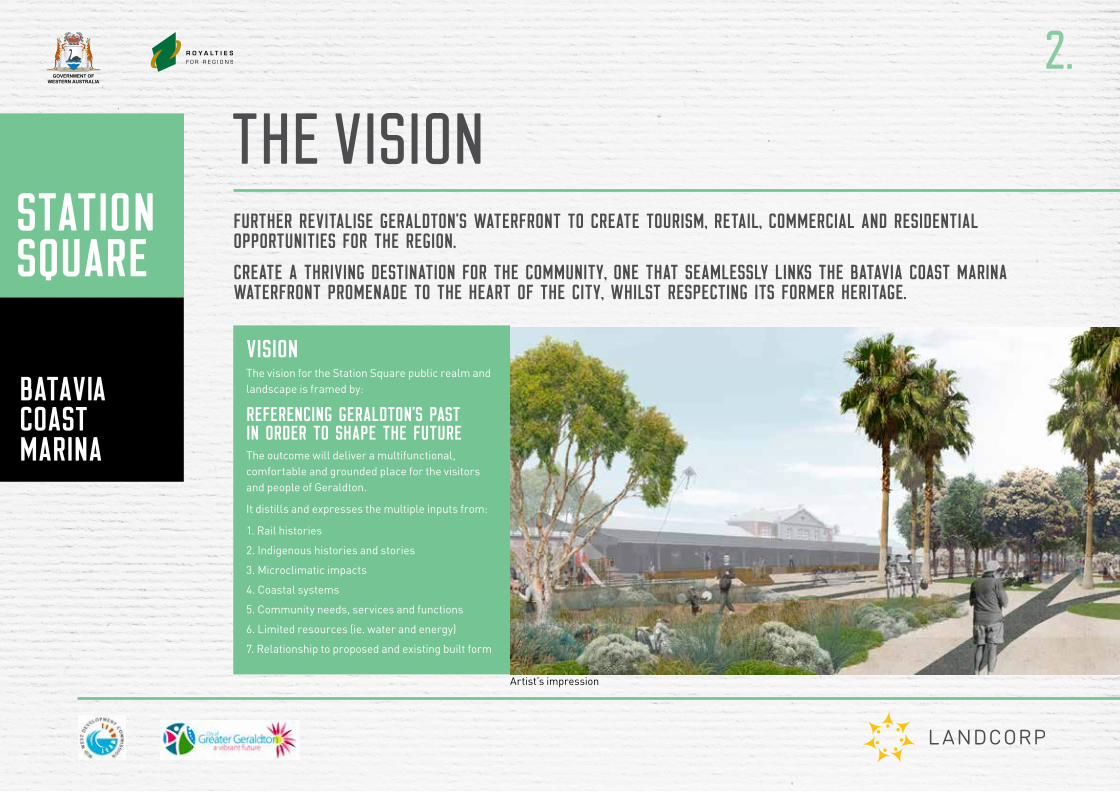
THE ROLE OF PRIVATE DEVELOPERSThe progress of this development will ultimately rely on private sector investment. That is why LandCorp together with the City Of Greater Geraldton and the Mid West Development Commission have been working to put the pieces in place to maximise the attraction for private developers.
Key to this will be for the site to offer a mix of uses that will create an active, well visited precinct.
• A mix of retail, cafes and restaurants, offices, permanent residential accommodation and visitor attractions.
• A community square, surrounded by shops and cafes, and featuring a playground, places to sit and eat, shaded areas, potential for an open-air entertainment area for small concerts or events, and potential for market stalls.
• Site planning for ease of access to the marina, the redeveloped foreshore, and the city centre. This will include road extensions.
3.
OVERVIEW
GOVERNMENT OFWESTERN AUSTRALIA
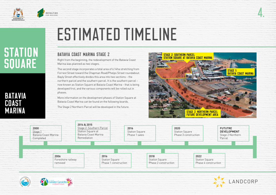
BATAVIA COAST MARINA STAGE 2Right from the beginning, the redevelopment of the Batavia Coast Marina was planned as two stages.
The second stage incorporates a total area of 6.14ha stretching from Forrest Street toward the Chapman Road/Phelps Street roundabout. Bayly Street effectively divides this area into two sections – the northern parcel and the southern parcel. It is the southern parcel – now known as Station Square at Batavia Coast Marina - that is being developed first, and the various components will be rolled out in phases.
More information on the development phases of Station Square at Batavia Coast Marina can be found on the following boards.
The Stage 2 Northern Parcel will be developed in the future.
4.
ESTIMATED TIMELINESTAGE 2: SOUTHERN PARCEL STATION SQUARE AT BATAVIA COAST MARINA
STAGE 2: NORTHERN PARCEL FUTURE DEVELOPMENT AREA
STAGE 1: BATAVIA COAST MARINA
2000Stage 1Batavia Coast Marina Completed
2006Foreshore railway removed
2016Station Square Phase 1 construction
2022Station Square Phase 4 construction
2014 & 2015Stage 2: Southern Parcel Station Square at Batavia Coast Marina Remediation
2016Station Square Phase 1 sales
2020Station Square Phase 3 construction
FUTUTRE DEVELOPMENTStage 2 Northern Parcel
2018Station Square Phase 2 construction
GOVERNMENT OFWESTERN AUSTRALIA
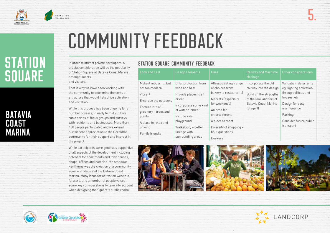
In order to attract private developers, a crucial consideration will be the popularity of Station Square at Batavia Coast Marina amongst locals and visitors.
That is why we have been working with the community to determine the sorts of attractors that would help drive activation and visitation.
While this process has been ongoing for a number of years, in early to mid 2014 we ran a series of focus groups and surveys with residents and businesses. More than 400 people participated and we extend our sincere appreciation to the Geraldton community for their support and interest in the project.
While participants were generally supportive of all aspects of the development including potential for apartments and townhouses, shops, offices and eateries, the standout key theme was the creation of a community square in Stage 2 of the Batavia Coast Marina. Many ideas for activation were put forward, and a number of people voiced some key considerations to take into account when designing the Square’s public realm.
STATION SQUARE COMMUNITY FEEDBACK Look and Feel Design Elements Uses Railway and Maritime
HeritageOther considerations
Make it modern … but not too modern
Vibrant
Embrace the outdoors
Feature lots of greenery – trees and plants
A place to relax and unwind
Family friendly
Offer protection from wind and heat
Provide places to sit or eat
Incorporate some kind of water element
Include kids’ playground
Walkability – better linkage with surrounding areas
Alfresco eating (range of choices from bakery to restaurants)
Markets (especially for weekends)
An area for entertainment
A place to meet
Diversity of shopping – boutique shops
Buskers
Incorporate the old railway into the design
Build on the strengths of the look and feel of Batavia Coast Marina (Stage 1)
Vandalism deterrents eg. lighting activation through offices and houses, etc.
Design for easy maintenance
Parking
Consider future public transport
5.
COMMUNITY FEEDBACK
GOVERNMENT OFWESTERN AUSTRALIA
6.
KEY CONSIDERATIONS
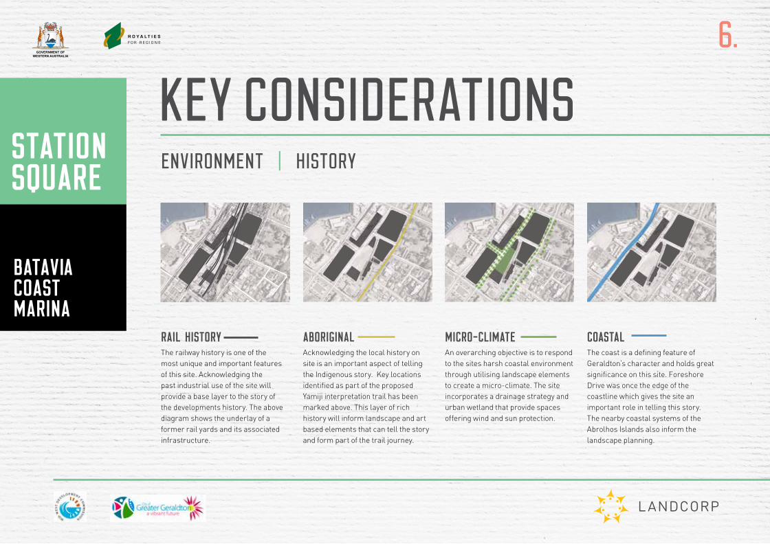
RAIL HISTORYThe railway history is one of the most unique and important features of this site. Acknowledging the past industrial use of the site will provide a base layer to the story of the developments history. The above diagram shows the underlay of a former rail yards and its associated infrastructure.
ABORIGINALAcknowledging the local history on site is an important aspect of telling the Indigenous story. Key locations identified as part of the proposed Yamiji interpretation trail has been marked above. This layer of rich history will inform landscape and art based elements that can tell the story and form part of the trail journey.
MICRO-CLIMATEAn overarching objective is to respond to the sites harsh coastal environment through utilising landscape elements to create a micro-climate. The site incorporates a drainage strategy and urban wetland that provide spaces offering wind and sun protection.
COASTALThe coast is a defining feature of Geraldton’s character and holds great significance on this site. Foreshore Drive was once the edge of the coastline which gives the site an important role in telling this story. The nearby coastal systems of the Abrolhos Islands also inform the landscape planning.
ENVIRONMENT | HISTORY
GOVERNMENT OFWESTERN AUSTRALIA
7.
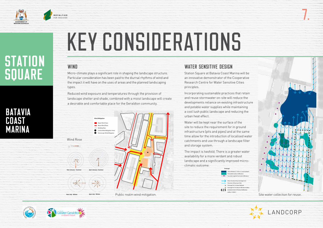
KEY CONSIDERATIONSWINDMicro-climate plays a significant role in shaping the landscape structure. Particular consideration has been paid to the diurnal rhythms of wind and the impact it will have on the uses of areas and the planned landscaping types.
Reduced wind exposure and temperatures through the provision of
landscape shelter and shade, combined with a moist landscape will create
a desirable and comfortable place for the Geraldton community.
Batavia Coast Marina Stage 2 - Public Realm Master Plan Report March 201540
BCM1
Development of the BCM1 site to the west of Station Square has been greatly controlled by the Batavia Coast Marina Structure Plan (Space Consultants, February 1999). This has resulted in many mixed use buildings of approximately 2 storeys in height. Buildings predominantly have small or no street and side setbacks with many ‘active’ ground level uses which open out onto a fairly consistent streetscape treatment. Parking is relegated to basements or the rear of lots.
Taller landmark buildings have occurred following council discretion, such as a small hotel and apartment complex. The museum presents itself as a landmark structure adjacent to the waterfront promenade. A small area of urban parkland is located to the rear of the museum. A series of open spaces are oriented to provide views and pedestrian connections to the waterfront. Tree lined Bayly Street has been developed as a smaller urban park providing an attractive link to the waterfront.
5.0 Strategies
Drainage is foccused on collecting all stormwater from the Station Square site up to a typical 10 year flood event. Overland drainage will either be directed towards the urban wetland or piped to storage underground for reuse in public toilets and the CoGG POS irrigation system. Smaller events with be infiltrated where possible through tree pits.
Drainage
Urban Wetland (~1315m2 @ varying depth)
Permeable Surface (infiltration)
Passively Irrigated Tree Grate (infiltration)
Minor Overland Flow Drainage Lines
Direction of Pavement Falls
Drainage Pits To Urban Wetland
Drainage Pits To Subsoil Infiltration Gallery
Indicative Extent Of Subsoil Infiltration
Gallery (~650m2)
Drainage
WATER SENSITIVE DESIGNStation Square at Batavia Coast Marina will be an innovative demonstrator of the Cooperative Research Centre for Water Sensitive Cities principles.
Incorporating sustainable practices that retain and reuse stormwater on-site will reduce the developments reliance on existing infrastructure and potable water supplies while maintaining a cool lush public landscape and reducing the urban heat effect.
Water will be kept near the surface of the site to reduce the requirement for in ground infrastructure (pits and pipes) and at the same time allow for the introduction of localised water catchments and use through a landscape filter and storage system.
The impact is twofold; There is a greater water availability for a more verdant and robust landscape and a significantly improved micro-climatic outcome.
Batavia Coast Marina Stage 2 - Public Realm Master Plan Report March 201522
5.0 Strategies
Microclimate plays a significant role in shaping the landscape structure, particularly in considering the diurnal rhythms of wind and the impact that this has on use and landscape type in relation to the foreshore/beach and the town centre.
The landscape structure establishes places of refuge, protected from the strong afternoon south westerlies, as a place for community activity and occupation.
Reduced wind exposure and temperatures through the provision of landscape shelter and shade, combined with a moist landscape will create a desirable and comfortable place for the new community and for the broader population of Geraldton.
Wind Mitigation
Major Wind Flows
Minor Wind Flows
Building Mass
1 Central Wind Mitigation Areas
2 Streetscape Wind Mitigation
Wind Mitigation
1
2
Rose of Wind direction versus Wind speed in km/h (01 Jan 1907 to 31 Oct 1953)Custom times selected, refer to attached note for details
GERALDTON TOWNSite No: 008050 • Opened Jan 1877 • Still Open • Latitude: -28.7769° • Longitude: 114.605° • Elevation 3m
An asterisk (*) indicates that calm is less than 0.5%.Other important info about this analysis is available in the accompanying notes.
NNE
E
SES
SW
W
NWN
CALM>= 0 and < 10
km/hCALM
>= 10 and < 20>= 20 and < 30
>= 30 and < 40>= 40
3 pm Jan1263 Total Observations
10%
20%
30%
40%
50%
60%
70%
Calm *
CopyrightCopyright © Commonwealth of Australia 2012 . Prepared on 30 Mar 2012Prepared by National Climate Centre of the Bureau of Meteorology.Contact us by phone on (03) 9669 4082, by fax on (03) 9669 4515, or by email on [email protected] have taken all due care but cannot provide any warranty nor accept any liability for this information.
TCZMONTH Page 1
Rose of Wind direction versus Wind speed in km/h (01 Jan 1907 to 31 Oct 1953)Custom times selected, refer to attached note for details
GERALDTON TOWNSite No: 008050 • Opened Jan 1877 • Still Open • Latitude: -28.7769° • Longitude: 114.605° • Elevation 3m
An asterisk (*) indicates that calm is less than 0.5%.Other important info about this analysis is available in the accompanying notes.
NNE
E
SES
SW
W
NWN
CALM>= 0 and < 10
km/hCALM
>= 10 and < 20>= 20 and < 30
>= 30 and < 40>= 40
9 am Jan1292 Total Observations
10%
20%
30%
40%
Calm 2%
CopyrightCopyright © Commonwealth of Australia 2012 . Prepared on 30 Mar 2012Prepared by National Climate Centre of the Bureau of Meteorology.Contact us by phone on (03) 9669 4082, by fax on (03) 9669 4515, or by email on [email protected] have taken all due care but cannot provide any warranty nor accept any liability for this information.
TCZMONTH Page 1
Rose of Wind direction versus Wind speed in km/h (01 Jan 1907 to 31 Oct 1953)Custom times selected, refer to attached note for details
GERALDTON TOWNSite No: 008050 • Opened Jan 1877 • Still Open • Latitude: -28.7769° • Longitude: 114.605° • Elevation 3m
An asterisk (*) indicates that calm is less than 0.5%.Other important info about this analysis is available in the accompanying notes.
NNE
E
SES
SW
W
NWN
CALM>= 0 and < 10
km/hCALM
>= 10 and < 20>= 20 and < 30
>= 30 and < 40>= 40
3 pm Jul1327 Total Observations
10%
20%
30%
Calm 2%
CopyrightCopyright © Commonwealth of Australia 2012 . Prepared on 30 Mar 2012Prepared by National Climate Centre of the Bureau of Meteorology.Contact us by phone on (03) 9669 4082, by fax on (03) 9669 4515, or by email on [email protected] have taken all due care but cannot provide any warranty nor accept any liability for this information.
TCZMONTH Page 1
Rose of Wind direction versus Wind speed in km/h (01 Jan 1907 to 31 Oct 1953)Custom times selected, refer to attached note for details
GERALDTON TOWNSite No: 008050 • Opened Jan 1877 • Still Open • Latitude: -28.7769° • Longitude: 114.605° • Elevation 3m
An asterisk (*) indicates that calm is less than 0.5%.Other important info about this analysis is available in the accompanying notes.
NNE
E
SES
SW
W
NWN
CALM>= 0 and < 10
km/hCALM
>= 10 and < 20>= 20 and < 30
>= 30 and < 40>= 40
9 am Jul1366 Total Observations
10%
20%
30%
Calm 4%
CopyrightCopyright © Commonwealth of Australia 2012 . Prepared on 30 Mar 2012Prepared by National Climate Centre of the Bureau of Meteorology.Contact us by phone on (03) 9669 4082, by fax on (03) 9669 4515, or by email on [email protected] have taken all due care but cannot provide any warranty nor accept any liability for this information.
TCZMONTH Page 1
Rose of Wind direction versus Wind speed in km/h (01 Jan 1907 to 31 Oct 1953)Custom times selected, refer to attached note for details
GERALDTON TOWNSite No: 008050 • Opened Jan 1877 • Still Open • Latitude: -28.7769° • Longitude: 114.605° • Elevation 3m
An asterisk (*) indicates that calm is less than 0.5%.Other important info about this analysis is available in the accompanying notes.
NNE
E
SES
SW
W
NWN
CALM>= 0 and < 10
km/hCALM
>= 10 and < 20>= 20 and < 30
>= 30 and < 40>= 40
9 am Jan1292 Total Observations
10%
20%
30%
40%
Calm 2%
CopyrightCopyright © Commonwealth of Australia 2012 . Prepared on 30 Mar 2012Prepared by National Climate Centre of the Bureau of Meteorology.Contact us by phone on (03) 9669 4082, by fax on (03) 9669 4515, or by email on [email protected] have taken all due care but cannot provide any warranty nor accept any liability for this information.
TCZMONTH Page 1
Wind Rose
9am January - Summer
Mean Monthly Rainfall
Mean Maximum Monthly Temperature
9am July - Winter 3pm July - Winter
3pm January- Summer
Wind Rose
Site water collection for reuse.
Batavia Coast Marina Stage 2 - Public Realm Master Plan Report March 201522
5.0 Strategies
Microclimate plays a significant role in shaping the landscape structure, particularly in considering the diurnal rhythms of wind and the impact that this has on use and landscape type in relation to the foreshore/beach and the town centre.
The landscape structure establishes places of refuge, protected from the strong afternoon south westerlies, as a place for community activity and occupation.
Reduced wind exposure and temperatures through the provision of landscape shelter and shade, combined with a moist landscape will create a desirable and comfortable place for the new community and for the broader population of Geraldton.
Wind Mitigation
Major Wind Flows
Minor Wind Flows
Building Mass
1 Central Wind Mitigation Areas
2 Streetscape Wind Mitigation
Wind Mitigation
1
2
Rose of Wind direction versus Wind speed in km/h (01 Jan 1907 to 31 Oct 1953)Custom times selected, refer to attached note for details
GERALDTON TOWNSite No: 008050 • Opened Jan 1877 • Still Open • Latitude: -28.7769° • Longitude: 114.605° • Elevation 3m
An asterisk (*) indicates that calm is less than 0.5%.Other important info about this analysis is available in the accompanying notes.
NNE
E
SES
SW
W
NWN
CALM>= 0 and < 10
km/hCALM
>= 10 and < 20>= 20 and < 30
>= 30 and < 40>= 40
3 pm Jan1263 Total Observations
10%
20%
30%
40%
50%
60%
70%
Calm *
CopyrightCopyright © Commonwealth of Australia 2012 . Prepared on 30 Mar 2012Prepared by National Climate Centre of the Bureau of Meteorology.Contact us by phone on (03) 9669 4082, by fax on (03) 9669 4515, or by email on [email protected] have taken all due care but cannot provide any warranty nor accept any liability for this information.
TCZMONTH Page 1
Rose of Wind direction versus Wind speed in km/h (01 Jan 1907 to 31 Oct 1953)Custom times selected, refer to attached note for details
GERALDTON TOWNSite No: 008050 • Opened Jan 1877 • Still Open • Latitude: -28.7769° • Longitude: 114.605° • Elevation 3m
An asterisk (*) indicates that calm is less than 0.5%.Other important info about this analysis is available in the accompanying notes.
NNE
E
SES
SW
W
NWN
CALM>= 0 and < 10
km/hCALM
>= 10 and < 20>= 20 and < 30
>= 30 and < 40>= 40
9 am Jan1292 Total Observations
10%
20%
30%
40%
Calm 2%
CopyrightCopyright © Commonwealth of Australia 2012 . Prepared on 30 Mar 2012Prepared by National Climate Centre of the Bureau of Meteorology.Contact us by phone on (03) 9669 4082, by fax on (03) 9669 4515, or by email on [email protected] have taken all due care but cannot provide any warranty nor accept any liability for this information.
TCZMONTH Page 1
Rose of Wind direction versus Wind speed in km/h (01 Jan 1907 to 31 Oct 1953)Custom times selected, refer to attached note for details
GERALDTON TOWNSite No: 008050 • Opened Jan 1877 • Still Open • Latitude: -28.7769° • Longitude: 114.605° • Elevation 3m
An asterisk (*) indicates that calm is less than 0.5%.Other important info about this analysis is available in the accompanying notes.
NNE
E
SES
SW
W
NWN
CALM>= 0 and < 10
km/hCALM
>= 10 and < 20>= 20 and < 30
>= 30 and < 40>= 40
3 pm Jul1327 Total Observations
10%
20%
30%
Calm 2%
CopyrightCopyright © Commonwealth of Australia 2012 . Prepared on 30 Mar 2012Prepared by National Climate Centre of the Bureau of Meteorology.Contact us by phone on (03) 9669 4082, by fax on (03) 9669 4515, or by email on [email protected] have taken all due care but cannot provide any warranty nor accept any liability for this information.
TCZMONTH Page 1
Rose of Wind direction versus Wind speed in km/h (01 Jan 1907 to 31 Oct 1953)Custom times selected, refer to attached note for details
GERALDTON TOWNSite No: 008050 • Opened Jan 1877 • Still Open • Latitude: -28.7769° • Longitude: 114.605° • Elevation 3m
An asterisk (*) indicates that calm is less than 0.5%.Other important info about this analysis is available in the accompanying notes.
NNE
E
SES
SW
W
NWN
CALM>= 0 and < 10
km/hCALM
>= 10 and < 20>= 20 and < 30
>= 30 and < 40>= 40
9 am Jul1366 Total Observations
10%
20%
30%
Calm 4%
CopyrightCopyright © Commonwealth of Australia 2012 . Prepared on 30 Mar 2012Prepared by National Climate Centre of the Bureau of Meteorology.Contact us by phone on (03) 9669 4082, by fax on (03) 9669 4515, or by email on [email protected] have taken all due care but cannot provide any warranty nor accept any liability for this information.
TCZMONTH Page 1
Rose of Wind direction versus Wind speed in km/h (01 Jan 1907 to 31 Oct 1953)Custom times selected, refer to attached note for details
GERALDTON TOWNSite No: 008050 • Opened Jan 1877 • Still Open • Latitude: -28.7769° • Longitude: 114.605° • Elevation 3m
An asterisk (*) indicates that calm is less than 0.5%.Other important info about this analysis is available in the accompanying notes.
NNE
E
SES
SW
W
NWN
CALM>= 0 and < 10
km/hCALM
>= 10 and < 20>= 20 and < 30
>= 30 and < 40>= 40
9 am Jan1292 Total Observations
10%
20%
30%
40%
Calm 2%
CopyrightCopyright © Commonwealth of Australia 2012 . Prepared on 30 Mar 2012Prepared by National Climate Centre of the Bureau of Meteorology.Contact us by phone on (03) 9669 4082, by fax on (03) 9669 4515, or by email on [email protected] have taken all due care but cannot provide any warranty nor accept any liability for this information.
TCZMONTH Page 1
Wind Rose
9am January - Summer
Mean Monthly Rainfall
Mean Maximum Monthly Temperature
9am July - Winter 3pm July - Winter
3pm January- Summer
Public realm wind mitigation.
GOVERNMENT OFWESTERN AUSTRALIA
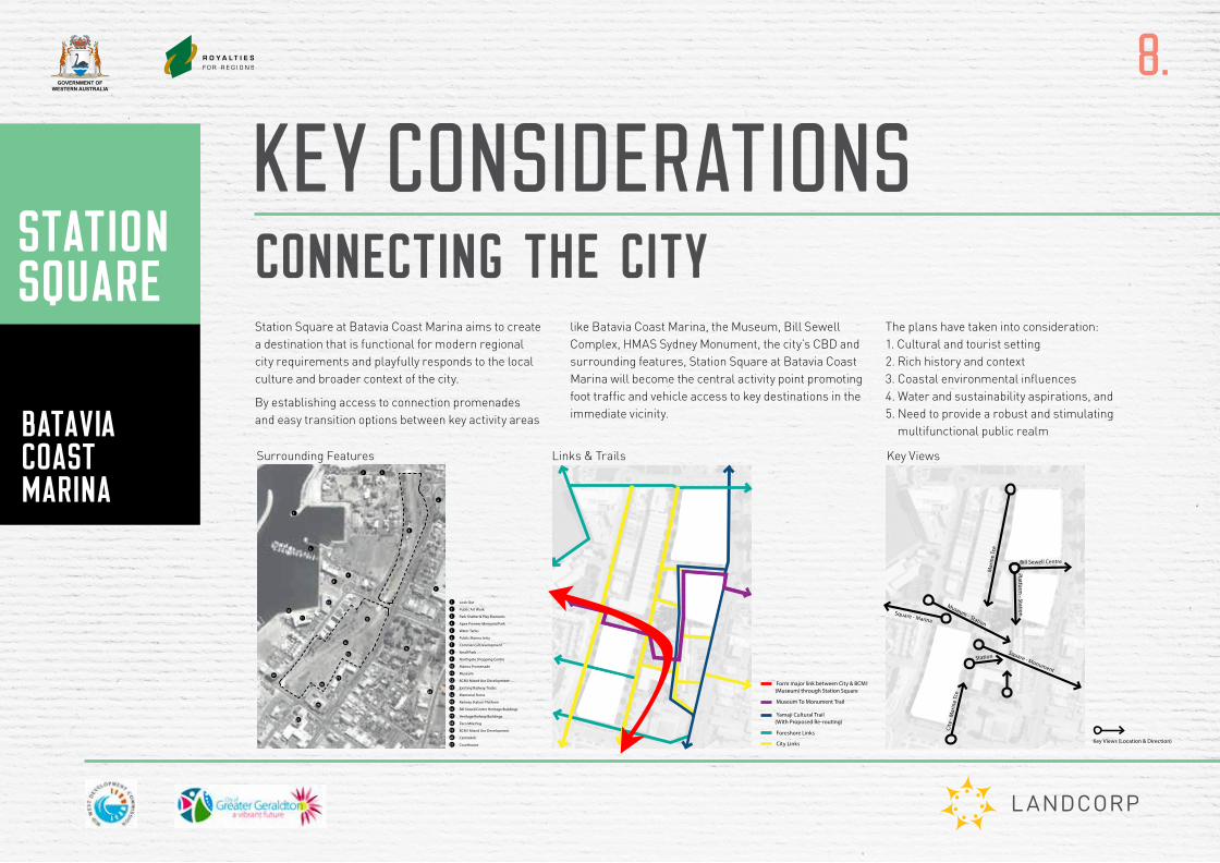
CONNECTING THE CITY
8.
KEY CONSIDERATIONS
Station Square at Batavia Coast Marina aims to create a destination that is functional for modern regional city requirements and playfully responds to the local culture and broader context of the city.
By establishing access to connection promenades and easy transition options between key activity areas
like Batavia Coast Marina, the Museum, Bill Sewell Complex, HMAS Sydney Monument, the city’s CBD and surrounding features, Station Square at Batavia Coast Marina will become the central activity point promoting foot traffic and vehicle access to key destinations in the immediate vicinity.
The plans have taken into consideration: 1. Cultural and tourist setting 2. Rich history and context 3. Coastal environmental influences 4. Water and sustainability aspirations, and 5. Need to provide a robust and stimulating
multifunctional public realm
5
2.0 Site and Character Analysis
1 Look Out
2 Public Art Work
3 Park Shelter & Play Elements
4 Apex Pioneer Memorial Park
5 Water Tanks
6 Public Marina Jetty
7 Commerical Development
8 Small Park
9 Northgate Shopping Centre
10 Marina Promenade
11 Museum
12 BCM1 Mixed Use Development
13 Existing Railway Tracks
14 Memorial Stone
15 Railway Station Platform
16 Bill Sewell Centre Heritage Buildings
17 Heritage Railway Buildings
18 Zero Mile Peg
19 BCM1 Mixed Use Development
20 Centrelink
21 Courthouse
Surrounding Features
4
9
16
20
21
17
18
11
6
7
8
12
10
19
15
14
22
1
3
5
2
13
1 Residential
2 Apex Pioneer Memorial Park
3 Residential
4 Service & Car Parking
5 Shopping Centre Car Parking
6 Single owner (Surrounded by Car Parking)
7 Mixed Use (BCM1)
8 Bill Sewell Centre
9 Mixed Commerical/Residential
10 Civic/City
7
8
9
10
1
3
2
4
5
6
Contextual Landuse & Character
19
Master Plan Elements
2 Unique Material Expression
3 Extension of Marine Terrace (Dark Green indicates
4 Extension of Musuem Place
5 Consistant Streetscape (To Mirror Opposite Condition)
Form major link between City & BCM1 (Museum) through Station Square
Museum To Monument Trail
Yamaji Cultural Trail (With Proposed Re-routing)
Foreshore Links
City Links
1 Proposed Car Parking
Existing Car Parking
Proposed Coach Drop Off Area
Pavement Treatments Links & Trails Parking
Key Views (Location & Direction)
Museum - Station
Square - Marina
Square - Monument
Station
Platform - Station
Bill Sewell Centre
City
- M
arin
e Tc
e
Mar
ine
Tce
Key Views
Links & Trails Key ViewsSurrounding Features
GOVERNMENT OFWESTERN AUSTRALIA
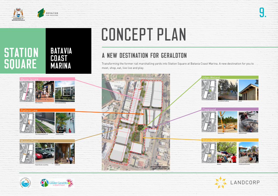
A NEW DESTINATION FOR GERALDTON
9.
CONCEPT PLAN
Transforming the former rail marshalling yards into Station Square at Batavia Coast Marina. A new destination for you to
meet, shop, eat, live live and play.
CH
AP
MA
N R
OA
D
MA
RI N
E T
ER
RA
CE
FO
RE
SH
OR
E D
RI V
E
B A Y L Y S T R E E T
M U S E U M P L A C E
Station Square - Public Realm Landscape Concept Report April 201510
5. Museum Place
Connector, existing character, educational
Marine Terrace
Musuem Place
Strip shopping
Perpendicular car parking Collonade Art Installation
Passive tree irrigation
Pedestrian crossing
Tree lined street New residential living
2.0
2.2 SITE ELEMENTS
Key Plan
Key Plan
Station Square - Public Realm Landscape Concept Report April 20158
Key Plan Markets
Natural ecologies
Outdoor dining
WSUD
Outdoor performance
Recreational walking Shelter
Events
Key Plan
Station Square
Urban Wetland
2.0
2.2 SITE ELEMENTS
Station Square - Public Realm Landscape Concept Report April 20158
Key Plan Markets
Natural ecologies
Outdoor dining
WSUD
Outdoor performance
Recreational walking Shelter
Events
Key Plan
Station Square
Urban Wetland
2.0
2.2 SITE ELEMENTS
Station Square - Public Realm Landscape Concept Report April 20158
Key Plan Markets
Natural ecologies
Outdoor dining
WSUD
Outdoor performance
Recreational walking Shelter
Events
Key Plan
Station Square
Urban Wetland
2.0
2.2 SITE ELEMENTS
9
Key Plan
Key Plan Parental surveliance
Post industrial public use
Sand and water
Reuse of existing rail infrastructure Outdoor dining
Vertical structures
Art light installation
Natural play
Playground
Platform Lane
9
Key Plan
Key Plan Parental surveliance
Post industrial public use
Sand and water
Reuse of existing rail infrastructure Outdoor dining
Vertical structures
Art light installation
Natural play
Playground
Platform Lane
9
Key Plan
Key Plan Parental surveliance
Post industrial public use
Sand and water
Reuse of existing rail infrastructure Outdoor dining
Vertical structures
Art light installation
Natural play
Playground
Platform Lane
Station Square - Public Realm Landscape Concept Report April 201510
5. Museum Place
Connector, existing character, educational
Marine Terrace
Musuem Place
Strip shopping
Perpendicular car parking Collonade Art Installation
Passive tree irrigation
Pedestrian crossing
Tree lined street New residential living
2.0
2.2 SITE ELEMENTS
Key Plan
Key Plan
Station Square - Public Realm Landscape Concept Report April 20158
Key Plan Markets
Natural ecologies
Outdoor dining
WSUD
Outdoor performance
Recreational walking Shelter
Events
Key Plan
Station Square
Urban Wetland
2.0
2.2 SITE ELEMENTS
Station Square - Public Realm Landscape Concept Report April 20158
Key Plan Markets
Natural ecologies
Outdoor dining
WSUD
Outdoor performance
Recreational walking Shelter
Events
Key Plan
Station Square
Urban Wetland
2.0
2.2 SITE ELEMENTS
9
Key Plan
Key Plan Parental surveliance
Post industrial public use
Sand and water
Reuse of existing rail infrastructure Outdoor dining
Vertical structures
Art light installation
Natural play
Playground
Platform Lane
9
Key Plan
Key Plan Parental surveliance
Post industrial public use
Sand and water
Reuse of existing rail infrastructure Outdoor dining
Vertical structures
Art light installation
Natural play
Playground
Platform Lane
9
Key Plan
Key Plan Parental surveliance
Post industrial public use
Sand and water
Reuse of existing rail infrastructure Outdoor dining
Vertical structures
Art light installation
Natural play
Playground
Platform Lane
Urban WetlandMarine Terrace
Platform Lane
Museum Place
Playground
Station Square

GOVERNMENT OFWESTERN AUSTRALIA
10.
YOUR STATION SQUAREAt the centre of Station Square at Batavia Coast Marina, a vibrant mixed-use plaza will offer a new meeting destination and
a range of activities including shops, eateries, public space, play and entertainment areas.
MEET | SHOP | EAT | LIVE | PLAY
A VIBRANT PLAZA SURROUNDED BY
SHOPS, EATERIES, OFFICES AND
ACCOMMODATION
LARGE CENTRAL PUBLIC SPACES DESIGNED TO ACCOMMODATE MARKETS AND ENTERTAINMENT
Playground
Staged entertainment area incorporating existing Station Platform and timber boxing to represent train carriages at the station
The plaza’s pavement detail and walkways symbolise some of the original train track locations
Marine Terrace road extension
Platform Lane designed as a mews and walkway
Urban wetlands
Abrolhos Island styled shelter and jetty boardwalk
MA
RIN
E TE
RR
ACE
Museum Place collanade walkway and parking
GOVERNMENT OFWESTERN AUSTRALIA
11.
YOUR STATION SQUAREDESIGN ELEMENTS
Island Jetties (boardwalk and ramp structures)
Abrolhos ‘Shack’ Shade Structure
Island Decks (extention of platform surface)
Station Platform (existing and resurfaced)
Abrolhos Island Jetty Structures
Abrolhos Structures
Platform Allee (Shade and Wind mitigation)
Coastal Grove (Shade and Wind mitigation)
Streetscape Plantings (Shade and Wind mitigation)
Awning Structure (with vines) & Colonnade on private lot
Urban Wetland (Thicket featuring wetland species)
Wind Catchers - Potential Art component
Sheltered Rear Dune Microclimate - Reinstating Former Ecologies
Microclimate - Ecology
Historical WAGR Rail Carriages
Interpretation Of Rail Heritage
1
3
2
Interpretation of Railway Carriages
Former Railway Lines reinterpreted in surface of square
Tree Grid (Aligning With Station Architecture)
Abrolhos Reef Patternation
Coastal Forms
Local historical elements have been incorporated into the design and provide subtle acknowledgments to the regions colourful past and present.
Urban Wetland (storage and treatment)
Coral Grasslands (flush turf areas)
Play Space (Integrated into Urban Wetland and Square)
Working diagram: Station Square detail plan
GOVERNMENT OFWESTERN AUSTRALIA
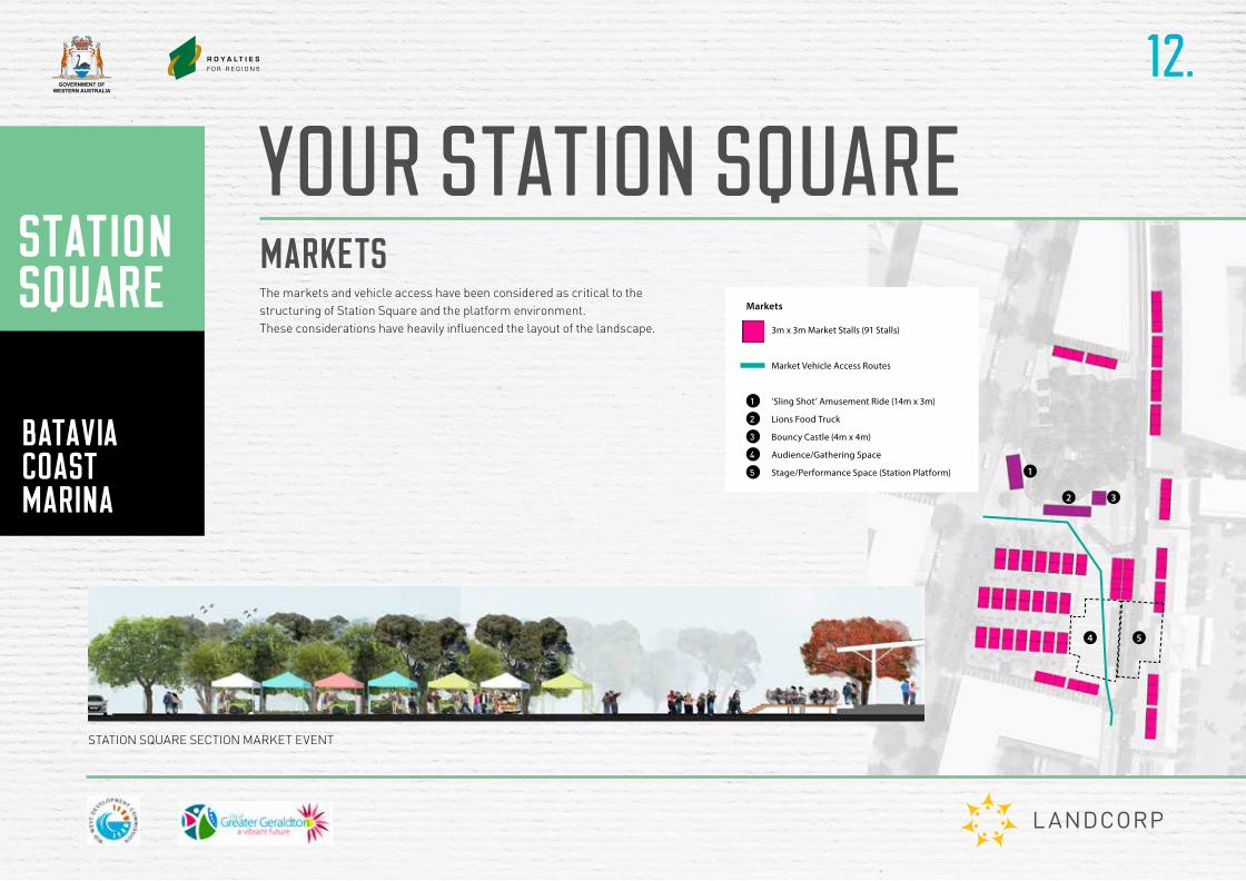
12.
YOUR STATION SQUAREMARKETSThe markets and vehicle access have been considered as critical to the structuring of Station Square and the platform environment.These considerations have heavily influenced the layout of the landscape.
STATION SQUARE SECTION MARKET EVENT
54
3m x 3m Market Stalls (91 Stalls)
Market Vehicle Access Routes
1 ‘Sling Shot’ Amusement Ride (14m x 3m)
2 Lions Food Truck
3 Bouncy Castle (4m x 4m)
4 Audience/Gathering Space
5 Stage/Performance Space (Station Platform)
Markets
1
2 3
4 5
GOVERNMENT OFWESTERN AUSTRALIA
13.
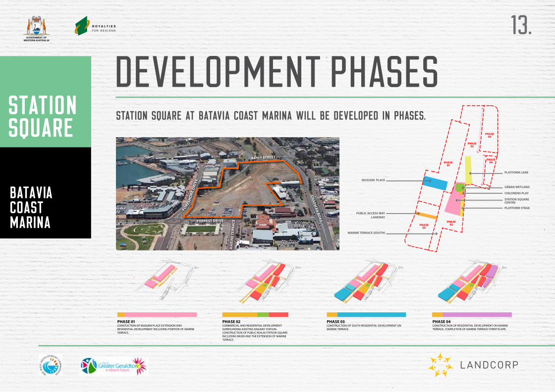
DEVELOPMENT PHASESSTATION SQUARE AT BATAVIA COAST MARINA WILL BE DEVELOPED IN PHASES.
FORESH
ORE
DRI
VE
MA
RIN
E TE
RRA
CE
CHA
PMA
N RO
AD
BAYLY STREET
FORREST DRIVE
7
PHASE 01
PHASE 04
PHASE 04
PHASE 02
PHASE 02PHASE
03
STATION SQUARE CENTRE
MARINE TERRACE (SOUTH)
PUBLIC ACCESS WAY LANEWAY
MUSUEM PLACE
PLATFORM LANE
URBAN WETLAND
PLATFORM STAGE
CHILDRENS PLAY
5
1.2 PROJECT STAGING
PHASE 01 CONSTUCTION OF MUSUEM PLACE EXTENSION AND RESIDENTIAL DEVELOPMENT INCLUDING PORTION OF MARINE TERRACE.
PHASE 02 COMMERCIAL AND RESIDENTIAL DEVELOPMENT SURROUNDING EXISTING RAILWAY STATION. CONSTRUCTION OF PUBLIC REALM STATION SQUARE INCLUDING BASIN AND THE EXTENSION OF MARINE TERRACE.
PHASE 03 CONSTRUCTION OF SOUTH RESIDENTIAL DEVELOPMENT ON MARINE TERRACE.
PHASE 04 CONSTRUCTION OF RESIDENTIAL DEVELOPMENT ON MARINE TERRACE. COMPLETION OF MARINE TERRACE STREETSCAPE.
GOVERNMENT OFWESTERN AUSTRALIA
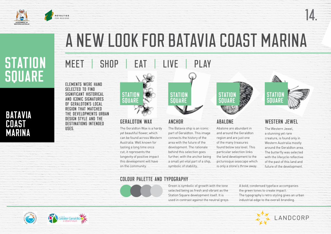
GERALDTON WAXThe Geraldton Wax is a hardy yet beautiful flower, which can be found across Western Australia. Well known for lasting a long time once cut, it represents the longevity of positive impact this development will have on the community.
ANCHORThe Batavia ship is an iconic part of Geraldton. This image connects the history of the area with the future of the development. The rationale behind this selection goes further, with the anchor being a small yet vital part of a ship, symbolic of stability.
ABALONEAbalone are abundant in and around the Geraldton region and are just one of the many treasures found below sea level. This particular selection links the land development to the picturesque seascape which is only a stone’s throw away.
WESTERN JEWELThe Western Jewel, a stunning yet rare creature, is found only in Western Australia mostly around the Geraldton area. The butterfly was selected with the lifecycle reflective of the past of this land and future of the development.
A NEW LOOK FOR BATAVIA COAST MARINA
Green is symbolic of growth with the tone selected being as fresh and vibrant as the Station Square development itself. It is used in contrast against the neutral greys.
A bold, condensed typeface accompanies the green tones to create impact. The typography’s retro styling gives an urban industrial edge to the overall branding.
COLOUR PALETTE AND TYPOGRAPHY
ELEMENTS WERE HAND SELECTED TO FIND SIGNIFICANT HISTORICAL AND ICONIC SIGNATURES OF GERALDTON’S LOCAL REGION THAT MATCHED THE DEVELOPMENTS URBAN DESIGN STYLE AND THE DESTINATIONS INTENDED USES.
MEET | SHOP | EAT | LIVE | PLAY
14.