LIVE OAK ASSOCIATES, INC. - usbr.gov
27
LIVE OAK ASSOCIATES, INC. an Ecological Consulting Firm MITIGATION AND MONITORING PLAN TRACT 4870 MILLERTON SPECIFIC PLAN AREA FRESNO COUNTY, CALIFORNIA Prepared by LIVE OAK ASSOCIATES, INC. Prepared for Bonadelle Development Corporation Attention: John Bonadelle, Jr. 2109 West Bullard, Suite 133 Fresno, CA 93711 November 8, 2004 File No. 110-07 San Jose Office. 6830 Via Del Oro, Suite 705 • San Jose. CA 95119 • Phone . 408-224-8300 • Fax: 408-224-1411 Oakhurst Office: P.O. Box 2697 • 49430 Road 426, Suite 8 • Oaki)urst, CA 93644 • Phone: 559-642-4880 • Fax: 559-642-4883
Transcript of LIVE OAK ASSOCIATES, INC. - usbr.gov
LIVE OAK ASSOCIATES, INC.an Ecological Consulting Firm
MITIGATION AND MONITORING PLANTRACT 4870
MILLERTON SPECIFIC PLAN AREAFRESNO COUNTY, CALIFORNIA
Prepared by
LIVE OAK ASSOCIATES, INC.
Prepared for
Bonadelle Development CorporationAttention: John Bonadelle, Jr.2109 West Bullard, Suite 133
Fresno, CA 93711
November 8, 2004 File No. 110-07
San Jose Office. 6830 Via Del Oro, Suite 705 • San Jose. CA 95119 • Phone . 408-224-8300 • Fax: 408-224-1411
Oakhurst Office: P.O. Box 2697 • 49430 Road 426, Suite 8 • Oaki)urst, CA 93644 • Phone: 559-642-4880 • Fax: 559-642-4883
TABLE OF CONTENTS
1.0 INTRODUCTION
2.0 WETLAND OPEN SPACE MITIGATION MANAGEMENT PLAN 7
APPENDIX A: PROPOSED REVISED MILLERTON SPECIFIC PLANMITIGATION MEASURES AND MONITORING PROGRAM MATRIX
APPENDIX B: NATIVE PLANT NURSERIES WITH PLANTING STOCKPOSSIBLY SUITABLE FOR THE WHITE FOX PARKWAY
APPENDIX C: ENGINEERS REPORT, ASSESSMENT FOR COUNTYOF FRESNO, COUNTY SERVICE AREA NO. 34, ZONE 'C'
ii Live Oak Associates. inc.

1.0 INTRODUCTION
This report constitutes a wetland and open space mitigation and management plan for Tract
4870, a residential subdivision to be constructed in the Millerton Specific Plan Area of Fresno
County, California. This plan is consistent with the original Millerton Specific Plan Mitigation
Measures and Monitoring Program Matrix measures 16.a through 16.h, as applicable to Tract
4870. These measures were derived from Hartesveldt (1998) and subsequent comments drafted
by the California Department of Fish and Game (date unlaiown).
The original matrix was based on a preliminary delineation of Waters of the United States
(jurisdictional waters) for the Millerton Specific Plan Area that was completed in 1997. A
revised study of jurisdictional waters was prepared and verified by the U.S. Army Corps of
Engineers in 2002. The original matrix ' made reference to wetlands identified in the preliminary
study that were determined not to be present in the subsequent study verified by the Corps. This
mitigation and monitoring report was based on the original matrix. A proposed revised matrix
based on the most recent delineation of jurisdictional waters has been provided in Appendix A.
Implementation of the measures listed in the document would mitigate to a less than significant
level anticipated project impacts to vegetation and wildlife resources of Tract 4870 that have
been identified in both matrixes.
Tract 4870 is located in the Millerton Specific Plan Area immediately south of proposed
commercial development adjacent to Millerton Road. The site is owned by JPJ, Inc. (formerly
Westcal, Inc.) of Fresno, California. That portion of the site proposed for development is•approximately 83 acres in size and is part of a larger 323-acre parcel that is also within the
Specific Plan Area. The Specific Plan Area is located approximately 10 miles to the north of the
City of Clovis (Figures 1 and 2). Tract 4870 can be found on the Friant U.S.G.S. 7.5 minute
quadrangle in Sections 10 and 15, Township 11 south, Range 21 east.
The proposed 83-acre project area includes proposed residential development, infrastructure
(streets, utilities, and stormwater drainage facilities), and open space corridors associated with
White Fox Creek and one tributary drainage (Figure 3). The mitigation and monitoring
1 Live Oak Associates, Inc.

N00
Ci
co"
0
(4-40
(1)
bA
cd'71
(1)"CScd
CID
a)
fV
4-•0
41;1
co
cdti
(1-40
8cd
a)
'CS0)
cHHd
0)
"c)
00)O0
O
er;
0
f:14
Ot-oo‘zt.
cd
0
Ual
4-,"c)0)
"c)cvs
bA
O
O•=4

Conservation planning for the site focused on protection of jurisdictional wetlands. The project
was designed to completely avoid impact to all wetlands, both on and off-site. One existing
crossing of White Fox Creek will accommodate Marina Drive, the main access road into the
site. Construction of this access road will not require that any earthen fill be deposited into the
channel or adjacent wetlands. Where Marina Drive would cross a tributary of White Fox Creek,
the applicant has committed to the construction of a clear span bridge that would avoid the need
to fill any portion of this tributary. A small wetland located near the northern boundary of Tract
4870 will be avoided. The principal wetland drainage passing through the site, White Fox
Creek, will be provided open space buffer on either side, thus establishing an open space
corridor along the creek that averages 200 feet in width, with widths of 300-400 feet at some
locations. This buffer will protect the creek from both direct and indirect impact associated with
nearby residential development.
It is important to note that the conservation planning associated with . Tract 4870 was part of a
broader effort to preserve contiguous areas of open space along White Fox Creek and a number
of tributaries. This open space corridor begins at the northeast corner of the Specific Plan Area
and continues in a southwesterly direction through Tract 4870 to the southwest corner of the
Specific Plan Area. This corridor will facilitate the movement of terrestrial vertebrates through
the Specific Plan Area, and provide riparian habitat suitable for a variety of wildlife species
known to forage and breed in the region. This open space corridor along White Fox Creek was
incorporated into the site plans of .various landowners in the Specific Plan Area after
consultation with the U.S. Army Corps of Engineers, the U.S. Fish and Wildlife Service, the
U.S. Environmental Protection Agency; and the California Department of Fish and Game.
The conservation planning for Tract 4870 culminates with this report that addresses the
mitigation measures found in Millerton Specific Plan, Mitigation Measures and Monitoring
Program Matrix. The measures found in this report are intended to maximize the value of open
space habitat of the site, while providing regular biological monitoring that will evaluate the
success of the mitigation measures in reducing impact to vegetation and wildlife resources from
the proposed development.
6 Live Oak Associates, Inc.


measures found in the matrix referenced above apply primarily to the open space corridor along
White Fox Creek.
The biotic resources of Tract 4870 and other parcels of the Specific Plan Area have been studied
since the spring of 1997. Stebbins (1997) identified at a preliminary level biotic habitats present,
and their constituent flora and fauna. A reconnaissance survey for the San Joaquin kit fox was
also completed. Hartesveldt conducted cursory field surveys of the entire Specific Plan Area in
1998 and from these surveys and the work of Stebbins he prepared Mitigation Plan, Millerton
New Town, Fresno County, California (1998) based on a preliminary analysis of impact from
proposed development. Live Oak Associates, Inc. subsequently conducted extensive monitoring
of shallow groundwater on Tract 4870 through the winter of 2000-2001 and prepared a
delineation of Waters of the United States (2001) that was verified by the U.S. Army Corps of
Engineers in a letter dated September 12, 2002. During the late spring and early summer of
2002, .Live Oak Associates, Inc. conducted a comprehensive San Joaquin kit fox den survey on
Tract 4870 that employed camera stations and tracking medium for the purpose of detecting any
individuals that may be present on the site.
The results of these various surveys were used to design the Tract 4870 subdivision project so as
to minimize impact to sensitive biotic resources and identify specific mitigation measures for
any impacts that might be considered significant. Jurisdictional wetlands identified on the site
were limited to 1.95 acres of freshwater seep/emergent marsh. An additional 0.48 acre of such
wetlands were present off-site in the general location of proposed off-site infrastructure
necessary for the development of Tract 4870. Vernal pool wetlands were absent from the site.
The nearest vernal pools to on-site development would be more than 300 feet to the west.
Studies conducted by Stebbins, Hartesveldt, and Live Oak Associates, Inc. indicate that state
and federally listed threatened or endangered plant and animal species do not occur on site. The
absence of vernal pools from the site precludes the occurrence of listed vernal pool species. The
site appears to be well outside the range of the San Joaquin kit fox. No evidence of kit foxes was
detected during den surveys. While other wildlife species of special status may occasionally
occur on site, the site does not provide significant habitat for them.
5 Live Oak Associates, Inc.

maintenance is to occur, then the nest site and a suitable buffer (as determined bya qualified biologist) shall remain off-limits to all maintenance activities until theconclusion of the breeding season. The CDFG recommends setbacks fromoccupied nest burrows of 100 meters where construction will result in the loss offoraging habitat.
• During the non-breeding season (August through January), resident owls may berelocated to alternative habitat. The relocation of resident owls shall beconducted according to a relocation plan prepared by a qualified biologist inconsultation with the California Department of Fish and Game. Passiverelocation as described in the aforementioned staff report will be the preferredmethod of relocation. The plan shall provide for their relocation to nearby openspace providing adequate nesting habitat.
Long-term maintenance will be the responsibility of County Service Area No. 34 under
contract with an appropriate private entity that will provide this service. Some
maintenance activities could require consultation with the California Department of Fish
and Game, the U.S. Army Corps of Engineers, and the California Regional Water
Quality Control Board. For example, erosion damage to the creek may require the re-
shaping of portions of the creek channel and the placement of rock armoring on eroded
creek banks. This work would not proceed until all required state and federal permits
had been obtained.
Submit the mitigation and management plan to the U.S. Army Corps ofEngineers for review.
This project will not require a Clean Water Act Permit from the U.S. Army Corps of
Engineers, because no jurisdictional waters subject to the Corps' permit authority will be
filled. Therefore, the mitigation and management plan need not be submitted to the U.S.
Army Corps of Engineers for review.
Funds for the Open Space Management Plan shall be part of the CSA No. 34budget.
Such funds will be provided based on a budget approved and collected by CSA No. 34
from individual homeowner users of CSA No. 34 so that the Open Space Management
Plan can be fully implemented. At the time this report was prepared, the total annual
budget for implementation of the Tract 4870 portion of the Specific Plan had been
17 Live Oak Associates, Inc.

calculated. Estimated fees to fund the Open Space Management Plan are included in
Engineers Report, Assessment for County of Fresno, County Service Area No. 34, Zone
'C' (Heyman & Associates 2004), which was prepared for Fresno County's review and
approval (see Appendix C). These fees will be established and approved by Fresno
County prior to recordation of the Final Tract 4870 Map. A copy of the Engineer's
report containing these and other fees is being submitted to the California Department of
Fish and Game.
k. Develop the Monitoring Program which, at a minimum, shall include;
Measurable mitigation objectives;Measures which will result in objectives being met;A monitoring protocol by which the success of the plan can be measuredthat identifies:
When monitoring will occur;Survey methods;Reporting requirements;
The primary mitigation measure' to be implemented on site is the preservation and
enhancement of native biotic resources in an open space corridor along White Fox
Creek. This open space corridor will be maintained and managed for the enhancement
and maintenance of native biotic resources, and to provide a scenic backdrop for a
recreational trail to be located along Marina Drive. These objectives will be met as
described in detail in MitigatiOn Measure 16.c. The success of the wetland and open
space mitigation and manageMent plan will be assessed during annual mitigation
monitoring surveys during the first 10 years following riparian plantings as described in
Measure 16.c. Annual monitoring will continue at a lesser level of effort in perpetuity.
This monitoring will be for the purpose of addressing open space issues identified in
Mitigation Measure 16.h.
Monitoring surveys will be conducted on foot in May of each year for 5 years after the
open space corridor along White Fox Creek has been planted. During the annual
monitoring surveys all numbered planting locations will be checked using the planting
plan in order to determine the status of the tree or shrubs planted at them. Trend
characteristics of planted trees will also be noted. Such characteristics will include
18 Live Oak Associates, Inc.

general health of individual trees and shrubs, amount of dieback, mortality, etc. Other
information gathered during the monitoring surveys would include any evidence of
noxious weeds in the open space corridor that may have become established, erosion
along the channel of White Fox Creek, maintenance requirements for the decorative
fence along the outer boundary of the open space corridor, and evidence of human
caused damage to biotic resources of the open space corridor.
The results of each monitoring survey will be summarized in an annual report that will
be submitted to the California Department of Fish and Game for review and comment.
I. Confirmation of a funding source for plan implementation.
As noted, funds will be provided CSA No. 34 for plan implementation. At the time this
report was completed, the funding source was to consist of an assessment on each of the
projects constructed in the Millerton Specific Plan Area, including Tract 4870. The final
budget for the Plan implementation shall be established and approved by Fresno County
prior to recordation of the Final Tract Map for Tract 4870.
MITIGATION MEASURE 16.g. The project proponent shall participate in the formationof a Open Space and Natural Resource Plan (OSNRP) for the Millerton, Dry Creek, andSierra Foothill areas. The OSNRP will provide protection of sensitive resources byestablishing key habitat areas, open and continuous wildlife corridors, ridgetop and viewprotection, native plant landscapes, and lighting restrictions on hilltops to mitigate glare.
The Millerton Open Space and Natural Resource Plan was developed partially in response to
Mitigation Measure 16.g and 16.h. In 1999, a group of developers, biologists, and land
managers who were collectively interested in the preservation of the natural resources of the
Millerton area drafted the Millerton Open Space and Natural Resource Plan to be administered
by a board of directors and to be implemented according to an adopted "Articles of
Organization". The geographic area covered by the plan is the entire Millerton New Town
Specific Plan Area (which included Tract 4870). This area has been already expanded to include
the nearby holdings of other private landowners. The plan calls for the collection of "impact
19 Live Oak Associates, Inc.

fees" for each residential unit constructed in the area covered by the plan. These fees are to be
paid to the Sierra Foothill Conservancy for the acquisition of land and protective easements on
lands in and around the Millerton area where future development will occur. Tract 4870 will
generate approximately $30,000 in impact fees that would be paid up front to the Sierra Foothill
Conservancy for the purchase of conservation easements on open space parcels in the area. The
Sierra Foothill Conservancy has targeted parcels on McKenzie Table, Big Table and in the
Sierra foothills adjacent to these geologically unique landforms for acquisition or conservation
easement. These lands are within 2-5 miles of Tract 4870. Therefore, the development of Tract
4870 will contribute to the mitigation of cumulative impacts that may result from regional
development in the future.
MITIGATION MEASURE 16.11 The project proponent shall pay a fair share of themitigation fees established by the OSNRP consistent with other projects within theOSNRP area, taking into account previous development commitments recognized in .theMillerton Specific Plan and the project conditions of approval that already include openspace set-aside and other protection Measures.
According to provisions of the Millerton Open Space and Natural Resource Plan, the project
proponent will pay impact fees of $175 per unit, but provision was made for fee increases over
time.
20 Live Oak Associates, Inc.

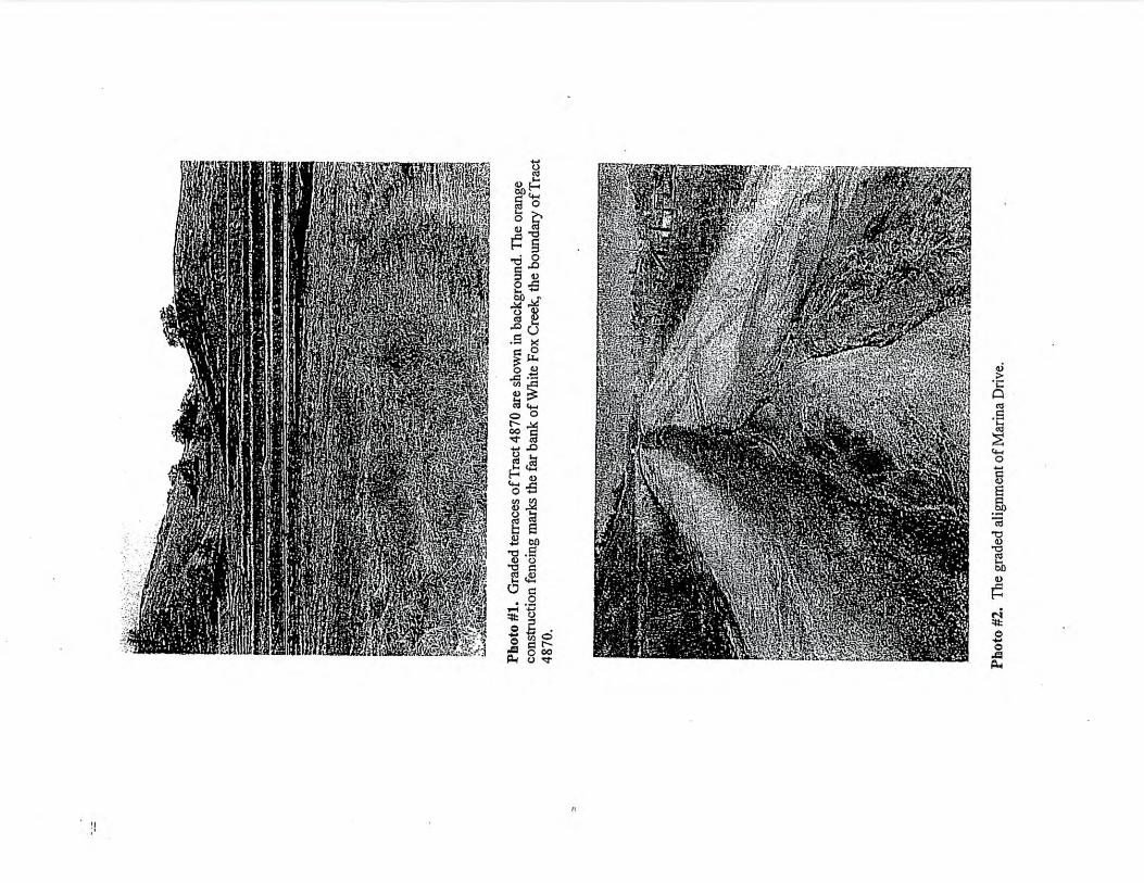
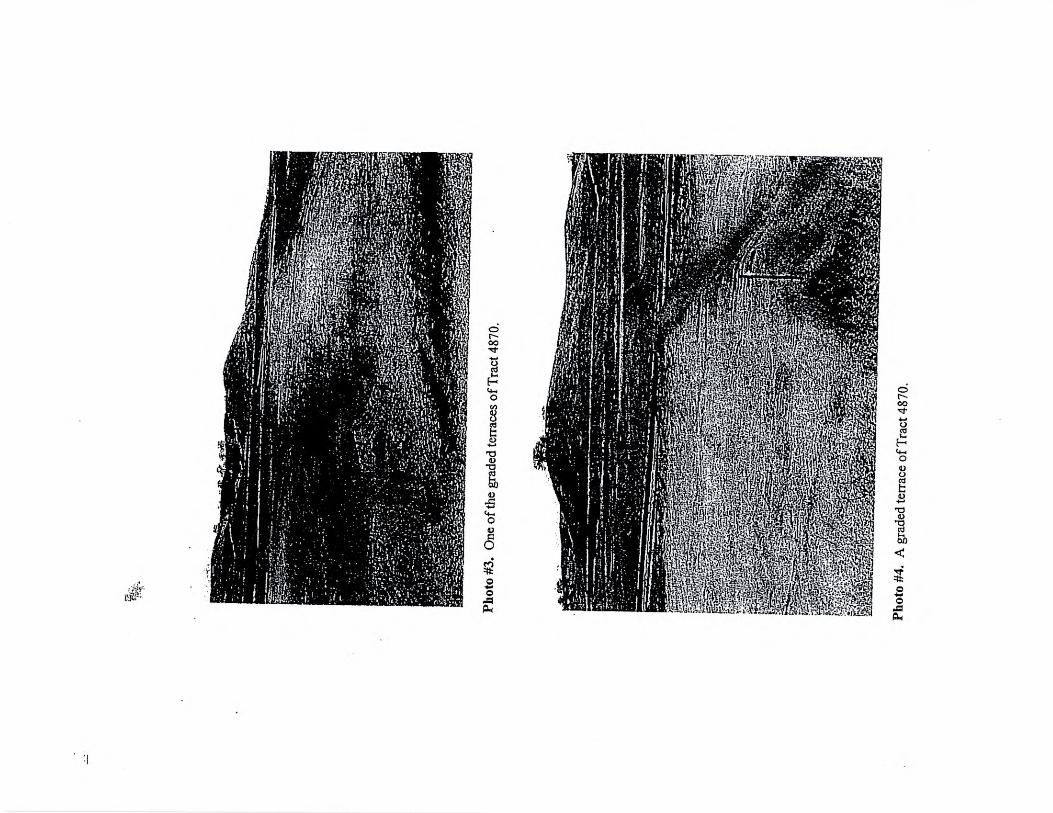
EXHIBIT DPHOTOGRAPHS: TRACT 4870
44

Site Location Map
)...-
,,7*..a'
i•- - Friant-I*
,fc.‘
1!Figure #
11/9/04 Project #
110-04Date
Regional Map
SeeVicinity Map
(left)
N
Live Oak Associates, Inc.
Millerton Wetland DelineationSite / Vicinity Map
basemao s courtesy: TOPOI
2 mi
0
2 miles
approximate scale
Vicinity Map
, - •
Madera Project location
See Site LocationMap (above)
aN
1:41,L.s1 volo.,1.•
:....... ., 1 I '
.,,, -_, ..... — ...-7..„... .r .• r 7:. • -...
\:. o..i.c. • ..' '... . .. -I - .41 11 • g I', ............. 1:\-... .,,,,,,,. , • • ".... ; .. a • & ;.--.......-..-.. - v.. •• 4 = i -,-
. •••••n•••::..... '..- ..! I • ". 7/.."......":;.; • I '.•n•nn:••—.
1 Iso/t •- • . 1 ‘....,,i .••• • i •
,..‘:\ / - T.::::•;......;-•-• — -
; % Fresno. r4-,: •12"-=:'":." '.'"f1"---=;"::.- .-- t-..-..... •-.1 1 . ---. - 4. \ • .. '•1 :Mr's-. -i ;.--,:; ,..• -. '
..... •• r'.. I. - ..‹.. • .:„.. .r.. , ::' r*,-.0 - • ^
• ...:- -.H.77- —
t.--4-E .? '...,t::::::_. , 1-_-_, :'•7. -7 ..--- -3; •
'--•.1 - • •
Not to scale

•.11,4, sA-• ,•
,k :1 • ...e •n •<e.,...)'• Ns. C7
'V .' • .„
0
•
rt• • *V."-'.
*, •
t..5:54.•1Jere,'
-1;•,. • to rv.,
,i^^rF,ti
„•4;".4ft";
e„1,
k- •
(
•
•
4.;
•
! r.. , t .( 7
, . 1 - • , •
• i ; --.:-*- '̀i • • - • 1-' :•...i'', fl (.
' ! ..V: 1 I -....,11.;--' .;,1
... .r.2;.11'--1.--,":.....-'•' i
`•1•
1*.k —PT)!•
-In
•
. " Crue l•,,•
.. • -•
•
'. Y.• ../}... I.
... .* ---;. ::;-'1' •
I e . 1 -; ' Ift.,
. 4 . • -$ .. • 2*1i i ," .. ;?' :.a1")
— . • - A1 :, ..
.-.'"-",-!:;:',..i:4*•-7, —I. .."'
,.4 • -ok, ,• ,•.;,• ••••••: .•• .7.....--,-\..11
..' . n I., • 1k .. • );,..,7,.-7.. ' •%.` .1.14i n Hr... -', .'. • .
f '.• ..;1:,:'
Project #110-04
1 mile 1 mile Date11/9/04
Figure #
Live Oak Associates, Inc.
Millerton Wetland DelineationU.S.G.S. Quadrangle
Approximate scale In miles

LEGEND
Vfa.:ILA Fox Cieek Open space Conidor
7.*
•4( : •; •.•
'•ig . r;
, •
=
.
.a: ,,ttiz f,-,:;"
.
O. • .,,,
Os . ‘, ... .-'\ . n•• ' N: ....;,. ..i,..‘ , ....j.:"..‘;.:o. ,•,,,,,,i'41:
•..? .:,... 1,.... : • it '', . ' :: • . I
/ i ,- . . .---2.,t,.7„...
r..`-.4.:.,;.•,,,
'.. , ,t....;:,% .,,,,, ‘
.. ,
\ ...: • —
.e.: • ' • .„,,,...' \ , \
#
: /6.,.z.,iik-*e.ki,•-
.---d • J,'
1 '„
1 , d t,,,,..... • ,..... n .. . ; . : • I . . , .,„;•;:1 ,...". ., . •
.... .. -V. f . .,.7.,......,!.:" .,
,
, ,, ... . .,:..- , s,.„,„. c. .
7. i 4,
' If,. . - . . ••• •i
ij. P .. ...."• ' 7 1 y-' . . ',:, .. n •71--; p„....; .. j. .' .. •:•••• P. , . :.;. ,
. ..
\
:
.
-...1'f: .,.,'''')\
n
., 4 •i 1 ,. I ..., ••,, ‘ , sV .
.• ‘ ••e-ii . I•e ‘
. \
;„ ...,.. . 6.
' i
\
I •,.............................
.:' i /I' ...2 .
1
i t
\•:i ;'•
"••••• • ••••• s: •..... .......„ • .... ••••••• ...... ' ' n;* :, ., \
' •-•" ...:.
••,,. . . .•••• '.
.‘ , \.(\wiC)
- ..,...; l;.%
:: ',,..,•••
.'s '' .,..ti;.:•,...:!1'..";'. ...„,' , \ \ . \ .., \
:•••:-' • k.:.:. \
) * '... \"\ ,.
:. .Y. •
\S?)c)1
0k••• ..,'• .
. s i,!•''
`n
\: •••
‘
••••-•.....••.....•.,.•••,,,.....••.... ••.... ••.- • ..i.,.......
L iv..-....... ...
I N0\1\'''C)4‘, ‘S e ,...::
\ .iio,......_•- .••.Live Oak Associates, Inc.
Tract 4570Project Plan
Dale
IPtoiectil ing11160trito4
110-07
-elkafr.,4-/ 4-
•
n••
, •n•
i\
,. •
.'n
""••!;'•
•••n •
: 1 •
...II •
\
.nn " • ••''
•
'.•
•
1.1. •-t:'•••• .;.(
:‘ • ••:. • '•*,
1•••";•ii" •••
;•V
<..; ..
,1021-- ...
.../....g:„" _v .
.... L.,.....„ , , . • ; . •••• _•.
)71 ,' 7:' 8 ':•
..- . A I t II: 46? • • •
'''..L...,........:•••....,...':..::
'-' \ \ \ ---.:',-% .,.. ,-,-: ;4 : •'''' .
!.... . • : .1 1 , .,:'
" 'I ' ..'.....!'... ....4!;..7 .' 1 ...:''''''.;....7. .Z.•
, /o •,.;.,...
3.:,:;T:....7.... ,r. \ •
. .,. t ono........1...n • .............7.:,..4go‘l..1':.:0;.n,;:t;•:.....i.* Oto. n ..:17'• nn••4, o'......"1.....n.411]...:1;i:',..6.. \I. :: ** ....."...:;tr".. •'/OP ....: A /"...../.:..../..L..... ' . . . . .... •
. / , \ ‘ „ • . • •,,,,., , ,
t ' i • • 141., • .---.... -4..,....... .....\ .....?:!•'••-• 1......:•;:,'''' ' `. ‘ '..,.., ,
.
•
500 feet
0 500 feet
Approximate scale
EXHIBIT EHABITAT ASSESSMENT: TRACT 4870
(LETTER FROM DR. MARK JENNINGS)
45
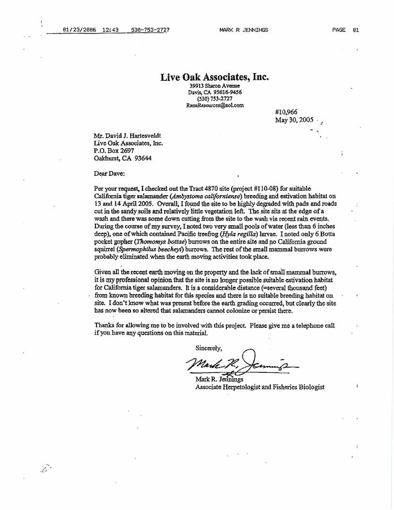
Sincerely,
Mark R. JenningsAssociate Herpetologist and Fisheries Biologist
01/23/2006 12:43 530-753-2727
MARK R JENNINGS PAGE 01
Live Oak Associates, Inc.39913 Sharon Avenue
Davis, CA 95616-9456(530) 753-2727
[email protected]#10,966May 30, 2005
Mr. David L. HartesveldtLive Oak Associates, Inc.P.O. Box 2697Oakhurst, CA 93644
Dear Dave:
Per your request, I checked out the Tract 4870 site (project #110-08) for suitableCalifornia tiger salamander (443nbystoma californiense) breeding and estivation habitat on13 and 14 April 2005. Overall, I found the site to be highly degraded with pads and roadsout in the sandy, soils and relatively little vegetation left. The site sits at the edge of awash and there was some down cutting from the site to the wash via recent rain events.During the course of my survey, I noted two very small pools of water (less than 6 inchesdeep), one of which contained Pacific treefrog (Hyla regilla) larvae. I noted only 6 Bottapocket gopher (Thornomys bottae) burrows on the entire site and no California groundsquirrel (Spermophilus beecheyi) burrows. The rest of the small mammal burrows wereprobably eliminated when the earth moving activities took place.
Given all the recent earth moving on the property and the lack of small mammal burrows,it is my professional opinion that the site is no longer possible suitable estivation habitatfor California tiger salamanders. It is a considerable distance ( =several thousand feet)from known breeding habitat for this species and there is no suitable breeding habitat onsite. I don't know what was present before the earth grading occurred, but clearly the sitehas now been so altered that salamanders cannot colonize or persist there.
Thanks for allowing me to be involved with this project. Please give me a telephone callif you have any questions on this material.
EXHIBIT FSAN JOAQUIN KIT FOX STUDY REPORT
PREPARED BY CURT UPTAIN
46
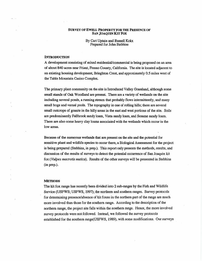
SURVEY OF EWELL PROPERTY FOR THE PRESENCE OFSAN JOAQUIN KIT FOX
By Curt Uptain and Russell KolaPrepared for John Stebbins
INTRODUCTION
A development consisting of mixed residential/commercial is being proposed on an area
of about 840 acres near Friant, Fresno County, California. The site is located adjacent to
an existing housing development, Brieghton Crest, and approximately 0.5 miles west of
the Table Mountain Casino Complex.
The primary plant community on the site is Introduced Valley Grassland, although some
small stands of Oak Woodland are present. There are a variety of wetlands on the site
including several ponds, a running stream that probably flows intermittently, and many
small bogs and vernal pools. The topography is one of rolling hills; there are several
small outcrops of granite in the hilly areas in the east and west portions of the site. Soils
are predominantly Fallbrook sandy loam, Vista sandy loam, and Sesame sandy loam.
There are also some heavy clay loams associated with the wetlands which occur in the
low areas.
Because of the numerous wetlands that are present on the site and the potential for
sensitive plant and wildlife species to occur there, a Biological Assessment for the project
is being prepared (Stebbins, in prep.). This report only presents the methods, results, and
discussion of the results of surveys to detect the potential occurrence of San Joaquin kit
fox ( Vulpes macrons mutica). Results of the other surveys will be presented in Stebbins
(in prep.).
METHODS
The kit fox range has recently been divided into 2 sub-ranges by the Fish and Wildlife
Service (USFWS; USFWS, 1997); the northern and southern ranges. Survey protocols
for determining presence/absence of kit foxes in the northern part of the range are much
more involved than those for the southern range. According to the description of the
northern range, the project site falls within the southern range. Hence, the more involved
survey protocols were not followed. Instead, we followed the survey protocols
established for the southern range(USFWS, 1989), with some modifications. Our surveys

consisted of a review of the California Natural Diversity Database (CNDDB) records for
previous kit fox sightings in the area, a site walkover to locate any potential or known fox
dens, night spotlighting surveys, and scent station surveys.
Review of California Natural Diversity Database Records
Recently, the CNDDB has eliminated all point records of San Joaquin kit fox from their
database. Instead, CNDDB has delineated polygons around those areas that are
considered important for kit foxes based upon previous sighting records. We generated a
map of these areas, using Arc/info. We also used an old version of the CNDDB files to
locate point records from near the project site.
Site Walkover
A site walkover was conducted to locate any potential or known kit fox dens.
Meandering transects were walked by 2 or more biologists at a distance that would allow
100% coverage of the site. These transects were walked in conjunction with surveys for
wetlands, sensitive plants, and other sensitive wildlife (e.g., burrowing owl and badger).
Accordingly, specific details of the walkover surveys, such as dates of surveys and other
findings, are presented in Stebbins (in prep).
Night Spotlighting Surveys
Night spotlighting was conducted on the project site for 3 consecutive nights frora May
20 to 22, 1997. Spotlighting was conducted by 2 observers with 100,000 candlepower
spotlights. At least 2 hrs. were spent spotlighting on the site each night . The routes used
provided excellent coverage of the site; spotlighting routes are shown in Stebbins (in
prep.).
Scent Station Surveys
Seven scent stations were established on the site. They consisted of a 1 meter-square
metal plate with fire clay spread on the surface. They were baited each evening with tins
of cat food and checked in the morning for 3 consecutive days between May 22 and 24,
1997. The locations of the stations are shown in Stebbins (in prep.).

RESULTS
Review of California Natural Diversity Database Records
According to the CNDDB polygon map of kit fox areas, the closest important area to the
project site is approximately 40 miles to the southwest (see Stebbins, in prep.). There are
2 previous sighting records that are relatively close to the project site. The closest one is
approximately 1.5 miles to the west near the town of Friant where a kit fox was observed
in 1994. The other record is from near the junction of Highway 99 and the San Joaquin
river, about 20 miles to the west. There are also 2 records to the south of the project site;
they are over 20 miles away and on the valley floor whereas our site is located in the
foothills.
Site Walkover
During the site walkover, we found no potential or known fox dens. For biological
resources that were found, see Stebbins (in prep.).
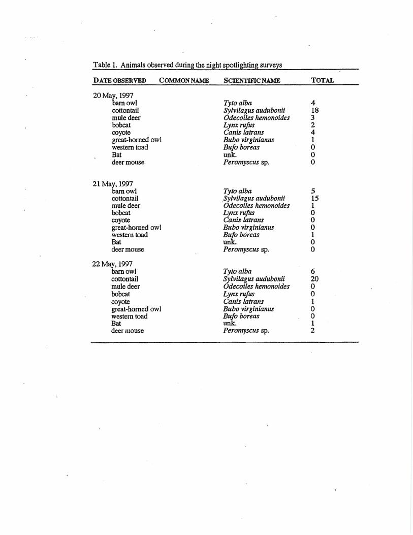
Night Spotlighting Surveys
During the night spotlighting surveys, we did not observe any kit foxes. We did observe
barn owls, cottontail, bobcats, coyotes, great-horned owls, western toads, and mule deer
(Table 1; see Stebbins, in prep.).
Scent Station Surveys
There were no kit fox tracks left on the scent stations. Most tracks left were of California
ground squirrels and cottontails, although coyotes, various birds, and voles also left
tracks at the stations (Table 2; see Stebbins, in prep.).
DISCUSSION
Although there is adequate prey, there are virtually no denning opportunities for foxes on
this site. The soil types that are present are shallow, categorized as being from 1.5 to 3.5
feet deep. On this site, the soils seem to be at the lower end of this range as evidenced by
the numerous rock outcrops. This would tend to preclude the presence of adequate dens
and, in fact, no dens were found. Kit fox predators were also relatively numerous on the
site. Previous records from the area are almost non-existent, mostly occurring at lower
elevations. The site is not in an area that is considered to be important for the recovery
kit foxes (Patrick Kelley, pers. comm.).

CONCLUSIONS
It is not likely that kit foxes inhabit this site and the site should not be considered
important to the recovery of kit foxes. Specific mitigation or compensation for loss of kit
fox habitat from the development of this site should not be considered appropriate.
LITERATURE CITED AND PERSONAL COMMUNICATIONS
Kelly, Patrick. Pers. Comm. Director of the Endangered Species Recovery PlanningProgram.
U. S. Fish and Wildlife Service. 1989. Standardized recommendations for the protectionof the San Joaquin kit fox. Unpubl rept. 14 pp.
U.S. Fish and Wildlife Service. 1997. San Joaquin kit fox survey protocol for thenorthern range. Unpubl. rept. 13pp.
515
00010
21 May, 1997barn owlcottontailmule deerbobcatcoyotegreat-horned owlwestern toadBatdeer mouse
22 May, 1997barn owlcottontailmule deerbobcatcoyotegreat-horned owlwestern toadBatdeer mouse
Tyto albaSylvilagus auduboniiOdecoiles hemonoidesLynx rufusCanis latransBubo virginianusBufo bdreasunk.Peromyscus sp.
Tyto alba 6Sylvilagus audubonii 20Odecoiles hemonoides 0Lynx rufus 0Canis latrans 1Bubo virginianus 0Bufo boreas 0unk. 1Peromyscus sp. 2
Table 1. Animals observed during the night spotlighting surveys
DATE OBSERVED COMMON NAME SCIENTIFIC NAME
TOTAL
20 May, 1997barn owlcottontailmule deerbobcatcoyotegreat-horned owlwestern toadBatdeer mouse
Tyto albaSylvilagus auduboniiOdecoiles hemonoidesLynx rufusCanis latransBubo virginianusBufo boreasunk.Peromyscus sp.
418324I000
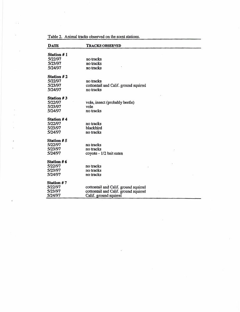
Table 2. Animal tracks observed on the scent stations.
DATE TRACKS OBSERVED
Station #5/22/97 no tracks5/23/97 no tracks5/24/97 no tracks
Station # 25/22/97 no tracks5/23/97 cottontail and Calif. ground squirrel5/24/97 no tracks
Station # 35/22/97 vole, insect (probably beetle)5/23/97 vole5/24/97 no tracks
Station # 45/22/97 no tracks5/23/97 blackbird5/24/97 no tracks
Station # 55/22/97 no tracks5/23/97 no tracks5/24/97 coyote - 1/2 bait eaten
Station # 65/22/97 no tracks5/23/97 no tracks5/24/97 no tracks
Station # 75/22/97 cottontail and Calif. ground squirrel5/23/97 cottontail and Calif. ground squirrel5/24/97 Calif. ground squirrel