Linking the conservation of culture and nature: A case study of … · 2008-05-09 · that...
32
Human Ecology, Vol. 29, No. 2, 2001 Linking the Conservation of Culture and Nature: A Case Study of Sacred Forests in Zimbabwe Bruce A. Byers, 1 Robert N. Cunliffe, 2 and Andrew T. Hudak 3 This paper examines the role of traditional religious beliefs and traditional leaders in conserving remnant patches of a unique type of dry forest in the Zambezi Valley of northern Zimbabwe. We examined aerial photographs spanning more than three decades, interviewed and surveyed local residents, and met with communities to learn about the environmental history of the forests and the factors that have affected land use in the area. Our results show that forest loss is dramatically less in forests that are now considered sacred, or were in the past connected to sacred forests. This supports our hypothesis that traditional spiritual values have influenced human behavior affecting the forests, and have played a role in protecting them until now. We also found that rates of forest loss have been much higher in an area where traditional leaders are relatively disempowered within the post-independence political system compared to an area where traditional leaders have more power. These findings lead us to conclude that a strategy that links the conservation of culture and nature is likely to be more effective in conserving forests than a strategy that ignores traditional beliefs, values, and institutions. KEY WORDS: conservation; forests; religion; sustainable use; wildlife; Zimbabwe. INTRODUCTION Creating parks and protected areas has often been viewed as the main land management strategy for conserving biological diversity. However, in- terest in conserving land outside of protected areas is growing (Reid, 1996; 1 405 Timber Lane, Falls Church, VA 22046 USA. e-mail: [email protected] 2 The Zambezi Society, P.O. Box HG 774, Highlands, Harare, Zimbabwe. 3 USDAForest Service, Forestry Sciences Laboratory, 3200 SWJefferson Way, Corvallis, OR 97331, USA. 187 0300-7839/01/0600-0187$19.50/0 C 2001 Plenum Publishing Corporation
Transcript of Linking the conservation of culture and nature: A case study of … · 2008-05-09 · that...

P1: MRM/RKP P2: MRM
Human Ecology [huec] PP120-300695 April 25, 2001 10:9 Style file version Nov. 19th, 1999
Human Ecology, Vol. 29, No. 2, 2001
Linking the Conservation of Culture and Nature:A Case Study of Sacred Forests in Zimbabwe
Bruce A. Byers,1 Robert N. Cunliffe,2 and Andrew T. Hudak3
This paper examines the role of traditional religious beliefs and traditionalleaders in conserving remnant patches of a unique type of dry forest in theZambezi Valley of northern Zimbabwe. We examined aerial photographsspanning more than three decades, interviewed and surveyed local residents,and met with communities to learn about the environmental history of theforests and the factors that have affected land use in the area. Our results showthat forest loss is dramatically less in forests that are now considered sacred,or were in the past connected to sacred forests. This supports our hypothesisthat traditional spiritual values have influenced human behavior affecting theforests, and have played a role in protecting them until now. We also foundthat rates of forest loss have been much higher in an area where traditionalleaders are relatively disempowered within the post-independence politicalsystem compared to an area where traditional leaders have more power. Thesefindings lead us to conclude that a strategy that links the conservation of cultureand nature is likely to be more effective in conserving forests than a strategythat ignores traditional beliefs, values, and institutions.
KEY WORDS: conservation; forests; religion; sustainable use; wildlife; Zimbabwe.
INTRODUCTION
Creating parks and protected areas has often been viewed as the mainland management strategy for conserving biological diversity. However, in-terest in conserving land outside of protected areas is growing (Reid, 1996;
1405 Timber Lane, Falls Church, VA 22046 USA. e-mail: [email protected] Zambezi Society, P.O. Box HG 774, Highlands, Harare, Zimbabwe.3USDA Forest Service, Forestry Sciences Laboratory, 3200 SW Jefferson Way, Corvallis, OR97331, USA.
187
0300-7839/01/0600-0187$19.50/0 C© 2001 Plenum Publishing Corporation
P1: MRM/RKP P2: MRM
Human Ecology [huec] PP120-300695 April 25, 2001 10:9 Style file version Nov. 19th, 1999
188 Byers, Cunliffe, and Hudak
Szaro & Johnston, 1996) and has attracted interest in part because of therealization that the reservation of even 10% of national territories will notbe enough to conserve most biodiversity (Soule & Sanjayan, 1998). Interestin conservation across a mosaic of land uses has also come about becausemany protected areas are “paper parks,” in which lack of resources preventsthe sustainable management and protection of the biodiversity they contain(Peres & Terborgh, 1995). Linking conservation and economic developmentis one strategy that has been used to motivate conservation outside of pro-tected areas. This strategy is based on the view that material values and directeconomic benefits are required to motivate conservation. Integrated con-servation and development projects (ICDPs) have tried to implement thisstrategy in many places (Brown & Wyckoff-Baird, 1992; Wells et al., 1992).
Southern African conservationists have been in the forefront in promot-ing sustainable uses of wild resources as the basis of conservation.Zimbabwe’s Communal Areas Management Programme for Indigenous Re-sources (CAMPFIRE) is one example of programs that link conservationand economic development (B. Child, 1996; G. Child, 1996; Metcalfe, 1994;Murphree, 1994). A fundamental assumption of the CAMPFIRE program isthat economic benefits are the key in motivating conservation in Zimbabwe’scommunal lands. Another fundamental assumption is that local communitiesmust have secure tenure and proprietorship over their natural resources inorder to be motivated to manage them sustainably. In Zimbabwe, where thecentral government formerly owned and managed natural resources suchas wildlife in the communal lands, implementing CAMPFIRE required thedevolution of authority to manage common-property natural resources toincreasingly local levels.
Traditional African religions often viewed land and its resources as com-munal property that belonged not only to the living but to their ancestorsand to future generations (Omari, 1990). In many cases, the relationshipbetween people and the land was a matter of spiritual concern, and suchreligions have been called “profoundly ecological” (Schoffeleers, 1978). Sa-cred sites on the landscape, including sacred forests, play a role in manyAfrican territorial religions. Studies of sacred forests and other sacred sitesthroughout Africa show that religious and spiritual beliefs can sometimesbe the motivation for conservation and environmental protection (Dorm-Adzobu et al., 1991; Ntiamoa-Baidu, 1995; Omari, 1990; Schoffeleers, 1978).A traditional sacred forest forms the core of a modern conservation areain southeastern Zimbabwe, the Rusitu Botanical Reserve (Hughes, 1995).Examples of the effect of religious values in protecting natural habitats arenot confined to Africa. In northeastern India, for example, 133 species ofnative plants are presently found only in sacred groves, presumably havingbeen extirpated from unprotected surrounding areas (Khan et al., 1997).

P1: MRM/RKP P2: MRM
Human Ecology [huec] PP120-300695 April 25, 2001 10:9 Style file version Nov. 19th, 1999
Linking the Conservation 189
Although we should be cautious not to overstate the strength of spiritualmotivations for environmental conservation, the studies cited above raisethe question of whether material and economic benefits are necessary orsufficient motivation for nature conservation in all cases, as the ZimbabweCAMPFIRE program assumes.
This paper explores two hypotheses:
• Traditional spiritual and religious values have influenced human be-havior toward the unique dry forests of the Muzarabani area of north-ern Zimbabwe, and have helped to protect these forests until now;and,• The relative empowerment of traditional leaders within the post-
independence system of government has influenced forest conser-vation in the Muzarabani area.
We use terms such as “traditional,” “modern,” and “culture” in this paper,recognizing the reservations held by some social scientists about the validityand utility of such constructs. These were often the terms local people usedin discussing their situation with us, however, and our use of these termsshould not be taken to suggest that we have a static view of Shona culture; infact this study deals directly with the issue of cultural dynamism and change.
STUDY AREA
Ecological Background
Sites of special interest for botanical conservation in the communallands of the Zambezi Valley of Zimbabwe were identified in a report pub-lished by the National Herbarium of Zimbabwe in 1991 (Timberlake et al.,1991). A reassessment was carried out in 1995 and 1996 by the Zambezi So-ciety, a nonprofit conservation organization dedicated to the conservation ofbiodiversity in the Zambezi River Basin. Information from the 1991 reportwas updated through inspection Landsat-TM satellite imagery dating from1992, and many of the sites were visited on the ground. The reassessmentidentified 82 sites of special botanical interest; 18 were judged to be of highpriority for conservation based on the national significance of their vegeta-tion and because they are seriously threatened with clearance or degradationof the natural vegetation (Timberlake & Cunliffe, 1997).
Four patches of a unique type of dry forest found in the MuzarabaniCommunal Lands of the Centenary District were among the high prioritysites. These patches ranged in size from about 70 to 300 hectares. This for-est type is a closed-canopy, dry-season deciduous forest comprised of an
P1: MRM/RKP P2: MRM
Human Ecology [huec] PP120-300695 April 25, 2001 10:9 Style file version Nov. 19th, 1999
190 Byers, Cunliffe, and Hudak
assemblage of indigenous woodland tree species. Several species of lianas(woody climbing vines) are present, and the forests have a thicket understorythat usually includes Acacia ataxacantha. These dry forests are found along anumber of rivers flowing into the Zambezi River from the south. They havedeveloped where patches of old, clay-rich alluvial soils, often heavily gullied,are exposed, and are restricted to these soils. This forest type is unique andrare in Zimbabwe, as well as being unusual in an area otherwise dominatedby shorter, sparser woodland vegetation of various types.
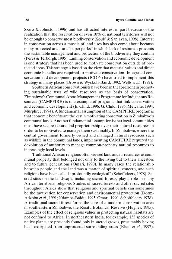
Our study area (centered at approximately 16◦20′S latitude, 30◦58′Elongitude) encompasses these Muzarabani dry forests (Figs. 1 and 2). Thevalley floor is flat, and the elevation ranges from about 390–430 meterswhere the forests are found. A few kilometers south of the study area theZambezi Escarpment rises steeply about 1000 meters, and to over 1600 m inthe Mvuradonha Mountains to the southeast (Surveyor-General, 1995). TheMusengezi and Utete Rivers, along which the dry forests are found, descendthrough steep gorges from the plateau on the top of the escarpment. The
Fig. 1. Location of the Muzarabani study area.
P1: MRM/RKP P2: MRM
Human Ecology [huec] PP120-300695 April 25, 2001 10:9 Style file version Nov. 19th, 1999
Linking the Conservation 191
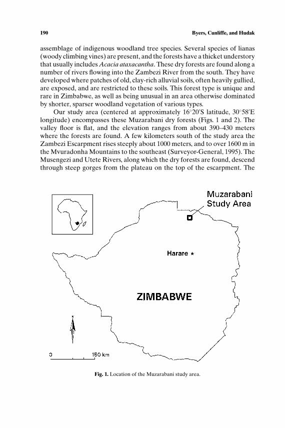
Fig
.2.L
ocat
ion
ofdr
yfo
rest
sin
the
Muz
arab
anis
tudy
area
.
P1: MRM/RKP P2: MRM
Human Ecology [huec] PP120-300695 April 25, 2001 10:9 Style file version Nov. 19th, 1999
192 Byers, Cunliffe, and Hudak
climate is semiarid (mean annual rainfall of 600–800 mm), with a short andconcentrated rainy season from November to March and a long dry seasonfrom April to October. Mean temperatures at Muzarabani range from 20◦Cin July to 29.5◦C in November (Cunliffe, 1992).
The Muzarabani dry forests are not known to harbor plant species thatare threatened or endangered elsewhere in Zimbabwe, and there are nospecies found only in these dry forests. This type of dry forest has specialbotanical interest, however, for at least three reasons: it is quite diversein woody plant species, it has a number of plants that are unusual or rarein Zimbabwe and/or the Zambezi Valley, and it is a unique assemblage ofspecies from several different ecological communities.
These attributes of the dry forests give them high scientific and educa-tional value (Timberlake & Cunliffe, 1997). Setting conservation prioritiesbased on unusual plant assemblages, as in this case, has not been as com-mon as a species-level focus based on criteria such as presence of rare orendangered species, species richness, or numbers of endemic species. Yet,there is increasing recognition that conservation should target whole eco-logical communities (Fearnside & Ferraz, 1995; Keel et al., 1993; Kiesteret al., 1996). The threat to the dry forests in Muzarabani also contributes totheir high priority for conservation. This forest type has always had a limiteddistribution, but was once more widespread. It has been largely cleared andconverted to other uses in other places, such as along the Manyame Riverin neighboring Guruve District (Timberlake & Cunliffe, 1997).
A study of elephant movements using radio-collaring techniques isbeing carried out in the Muzarabani area (Hoare, 1998). Preliminary re-sults show that elephants use the Muzarabani sacred forests as refuges forsignificant periods of time, especially during the dry season when musawu(Ziziphus mauritiana) fruit are ripe. In 1998, for example, a group of about10 bulls spent 2–3 months in the Kapara, Katepa, and Chamaturi Forests.Some animals have been observed to move through the Muzarabani forestsas they travel between the Mvuradonha Mountains and areas to the northin Guruve District and into Mozambique (G. Parker, pers. comm.).
Cultural Background
During site visits to the dry forests along the Musengezi River, thebotanists who carried out the Zambezi Society study were told by local peo-ple that at least some of the forest patches are protected by ancestral spiritswhich are said to inhabit them, and which would seek revenge on thosewho carry out unauthorized tree cutting (Timberlake & Cunliffe, 1997). TheShona believe that when people die their spirits return to dwell among their
P1: MRM/RKP P2: MRM
Human Ecology [huec] PP120-300695 April 25, 2001 10:9 Style file version Nov. 19th, 1999
Linking the Conservation 193
descendants. These ancestral spirits are thought to often take the physicalforms of wild animals. The most powerful spirits are those of former chiefs,called mhondoro, which are believed to take the form of lions. Mhondoroare viewed as guardian spirits of a place. They concern themselves with thewelfare of their descendants, and with maintaining harmonious relationsbetween people and the land and respect for sacred places (Bourdillon,1987). These mhondoro spirits are thought to communicate with modernpeople through spirit mediums, the most powerful traditional religious lead-ers. Mediums are thought to become ritually possessed by their spirit duringspecial ceremonies, and the mhondoro can then be asked for and give ad-vice about issues of concern. A ritual assistant, called a mutapi, organizesceremonies and carries out other religious duties on behalf of the medium(Bourdillon, 1987; Lan, 1985). Mutapis are sometimes traditional villageleaders, or sabhukus, thus having a role both in the traditional religious andpolitical systems.
In the Shona language the word sacred, inoera, is an adjective describinga thing or place. Sacredness has the connotation of being life sustaining, suchas providing food, fruit, or water. The concept is closely linked with rain, andthe fertility of the land. A sacred place (nzvimbo inoera) is a place wherespirits are present; it has certain rules of access, as well as behaviors thatare not allowed there (taboos). In Shona religion, a place is sacred if a spiritmedium says it is, because the ancestral spirit possessing the medium ofcourse knows what is sacred and what is not.
Territorial cults are a type of religious institution found widely through-out Central Africa. Schoffeleers (1978) calls them “profoundly ecologi-cal . . . [A]part from engaging in ritual action, however, they also issue andenforce directives with regard to a community’s use of its environment.” Ter-ritorial cults operate on the principle that “management of nature dependson the correct management and control of society” (Schoffeleers, 1978).
Religion has a complex interaction with traditional secular politics inShona culture. For example, when a chief dies, his successor is supposed to beapproved by a spirit medium; also some sabhukus (village heads) also serveas mutapis of spirit mediums; and chiefs and sabhukus are supposed to en-force respect for sacred sites, and fine or otherwise punish people who breakthe rules. Religion also interacts with modern secular politics, which itselfhas a complex and sometimes tense relationship with the traditional politi-cal system (Derman, 1996; Lan, 1985; Schoffeleers, 1978; Spierenburg, 1995).Religion provides a mechanism for social communication, conflict manage-ment and dispute resolution, and a system of checks and balances to both tra-ditional and modern political leaders. Spierenburg (1995) considers Shonareligion “ . . . a platform where sociopolitical issues can be discussed,” andSchoffeleers (1978) writes that because of its “directly ecological authority”

P1: MRM/RKP P2: MRM
Human Ecology [huec] PP120-300695 April 25, 2001 10:9 Style file version Nov. 19th, 1999
194 Byers, Cunliffe, and Hudak
it is pushed into involvement in secular politics. While the strength and im-portance of religion in Shona society should not be overstated or idealized,it also cannot be ignored.
Political Background
After Zimbabwean independence in 1980, a new system of local gov-ernment was introduced, in which the basic unit is the village, a groupof 100–200 households. Villages elect Village Development Committees(VIDCOs), which have representatives on the Ward Development Com-mittee (WADCO), with wards consisting of groups of four to seven villages.(B. Child, 1996; Spierenburg, 1995). These elected bodies were originallyintended to replace the traditional political leaders at the local scale, thesabhukus, who were usually older men of the main family comprising a vil-lage. In practice, the traditional political system still continues to functionalongside the post-independence system. At a slightly larger scale of or-ganization in the modern political system, each ward elects a councilor torepresent it as a member of the Rural District Council.
The enactment of the Communal Lands Act of 1982, and repealing of theTribal Trust Lands Act of 1979, shifted land allocation authority from tradi-tional political leaders to District Councils (Derman, 1996). Traditional lead-ers have no legal means to compel modern leaders to respect traditional landuse rules. “The chiefs have no legal power to create and enforce rules on natu-ral resource management in communal lands. Legally, this power rests withthe Rural District Councils (RDCs), who may make decisions . . . withoutconsulting the chief or taking account of customary resource managementrules and practices” (Maphala, 1994). Rural District Councils have the au-thority to pass district-specific by-laws, however, including those which gov-ern the protection and management of common-property natural resources,such as forests and wildlife (Musvoto, 1994). Although the Communal LandsAct gave legal power over land allocation to Rural District Councils, in ac-tual practice the allocation of land is still often done by traditional leaders.Authority to allocate land is ambiguous, and conflicts often arise.
Economic Background
Rapid social and economic changes have occurred in the Zambezi Val-ley over the last four decades. In 1960, settlements in the study area weresparse and scattered, and population density was low—estimated at 1.6 per-sons per square kilometer in this area in 1962 (Cunliffe, 1992). The original

P1: MRM/RKP P2: MRM
Human Ecology [huec] PP120-300695 April 25, 2001 10:9 Style file version Nov. 19th, 1999
Linking the Conservation 195
inhabitants of the area were mainly members of the Korekore ethnic divi-sion of the Shona. The nearest road was some distance north of the studyarea. In the mid-1960s the Gutsa smallholder irrigation scheme was built onthe west side of the Musengezi River in the study area. Its irrigated fieldswere not cleared from a forested area. The irrigation works were damagedby flooding in the 1970s and the fields reverted to dryland cropping. In theearly 1970s a larger irrigation scheme was developed southeast of the studyarea. Both of these irrigation schemes accelerated agricultural developmentand helped introduce cash crops such as cotton. The first paved road into thearea connected Muzarabani with Centenary in the mid-1960s. Further roaddevelopment took place in the late 1970s, stimulated by the independencewar. Cattle production in the Zambezi Valley was constrained by the preva-lence of tsetse fly and trypanosomiasis until the 1960s, when a combinationof programs to eradicate the fly and drugs for controlling the disease madecattle raising much more successful (Cunliffe, 1992; Derman, 1995).
These developments provided a “pull” for immigration into the Muzara-bani area. The “push” came from land ownership patterns, both before andafter Zimbabwean independence, in which much of the best agricultural landin the country was owned by a small number of commercial farmers. Karangapeople, another ethnic division of the Shona, immigrated to Muzarabani ina wave in the 1970s, and Zezuru immigrated in pulses in the 1960s and 1980s.By 1969 the population density in this part of the Valley was estimated to be2.5 persons per square kilometer; by 1982, 5.0 per square km; and by 1992,8.5 per square km. A UNDP study estimates that by 2002 the populationdensity will be 11.4 persons per square km, an increase of almost tenfold infour decades (Cunliffe, 1992).
A 1997 feasibility study for the proposed Silverstroom Dam on theMusengezi River found that the typical rural household in the Muzarabaniarea cultivated an average area of 4.1 hectares, from which they earned amean income of $9,153 Zimbabwe dollars (approximately $900 US dollars in1997). Of this cash income, 46% was derived from cotton, 28% from maize,and 26% from other crops. Cotton cultivation is expanding rapidly.
The Muzarabani Rural District Council (RDC) participates in theCAMPFIRE program, and has the authority to manage the wildlife andother natural resources of the district for economic benefit. The DistrictCouncil has leased a hunting concession, and elephant, sable, kudu, buffalo,and other game are taken by foreign sport hunters. From 1993 to 1996 theMuzarabani RDC earned roughly US$20,000 per year from this sport hunt-ing (Metcalfe, 1997; Muzarabani Rural District, 1995; Zambezi Society, nodate). A significant proportion of this income—70% in 1995, for example—is used to carry out community projects in the wards where the hunting tookplace, such as building clinics and schools (Muzarabani Rural District, 1995).

P1: MRM/RKP P2: MRM
Human Ecology [huec] PP120-300695 April 25, 2001 10:9 Style file version Nov. 19th, 1999
196 Byers, Cunliffe, and Hudak
Trophy bull elephants are especially valuable, bringing about US$8,000–10,000 each (B. Child, 1996; Muzarabani Rural District, 1995). Records of thelocations of successful elephant hunts in Muzarabani indicate a strong cor-relation with the natural forest patches. Between 1994 and 1998, nine of the20 elephants shot in the entire district of thousands of square kilometers wereshot within two kilometers of the Muzarabani forests. Although sport hunt-ing has been the major source of revenue from Muzarabani’s CAMPFIREprogram, other activities have also contributed, including tourism in theMvuradonha Wilderness Area and the sale of live animals.
METHODS
Our main fieldwork took place from June to December, 1997, and inAugust, 1999; one of us (R. Cunliffe) was in regular contact with people inMuzarabani between those two periods. We obtained aerial photographs ofthe Muzarabani area taken in 1960, 1966, 1973, 1981 (Department of Vet-erinary Services), and 1993 (WWF-Zimbabwe). These photos often servedas our maps in the field, and vegetation on the ground was compared withthe photos in numerous locations. A Geographic Information System (GIS)showing major topographic features was created by digitizing from a 1:25,000orthophoto of the area (Office of the Surveyor-General of Zimbabwe).Boundaries of forest patches identified on the 1960 and 1993 aerial pho-tos were digitized onto this base map.
We traveled throughout the Muzarabani area with local guides, visitingsites and interviewing local residents. We sometimes showed aerial photos toour informants as we discussed the environmental changes that had occurredin the area over the last four decades. From these interviews and site visits wedeveloped an understanding of the social, political, and economic changesthat had occurred over time to cause the changes in vegetation visible in theaerial photos.
Independently of the Zambezi Society’s 1995–1996 botanical study, anexercise to map sacred sites in Muzurabani Communal Lands was under-taken. A local research assistant traveled around the area and interviewedsabhukus and mutapis in order to identify and locate sites of special spiritualsignificance. By June, 1997, when we first integrated the information on sa-cred sites with the botanical information, more than 30 sacred sites had beenidentified. Even more sacred sites were identified during our subsequentfieldwork as we talked to traditional leaders who had not been contactedearlier.
In order to learn more about local knowledge of, and respect for, sa-cred sites, we developed a short written questionnaire. The questionnaire

P1: MRM/RKP P2: MRM
Human Ecology [huec] PP120-300695 April 25, 2001 10:9 Style file version Nov. 19th, 1999
Linking the Conservation 197
was in English, with some key words translated into Shona. A teacher atMuzarabani Secondary School administered a pilot version to 17 studentsfrom the area in which the Muzarabani dry forests are found. The surveywas then improved based on the responses to the pilot version, and the re-vised version was given to 21 additional students. These students also gavea copy to a parent, grandparent, or other older relative. For those questionsthat were also the same as on the pilot version of the survey, the maximumsample size was therefore 59 respondents (38 students, 21 elders). All of thestudents understood English, as did many of the elders; some students trans-lated the survey for their older relative. The teacher offered all students anopportunity to participate, and the return rate was high. The sample was notstratified or necessarily random, but constituted as nearly complete a sampleof the population of students as could be obtained. For some questions therewas no significant difference in response between students and elders, andthe responses of the two groups were pooled.
A final stage of our research involved meetings with residents of vil-lages located near the forests. These meetings were planned, announced,and attended by members of the Muzarabani Rural District Council, includ-ing the Council Chairman, Chair of the Natural Resources Committee (alsoknown as the CAMPFIRE Committee), and elected councilors from thethree wards in which the forests are found.
RESULTS
Forest Change
Aerial photographs from 1960 and 1993 show significant changes in thedry forests of the Muzarabani area (Fig. 3). Forest area has been reduceddue to the complete clearing and elimination of some patches, and to thereduction in size of other patches from clearing around the edges. Once-continuous forests have been fragmented into several smaller patches insome cases. In 1960 there were 22 patches of this forest type in the area wemapped. By 1993, 18 of these 22 patches—generally the smallest ones—hadbeen completely cleared. The remaining four patches were reduced in sizeand fragmented into 14 patches by 1993.
Table I presents a breakdown of the data on forest loss along twodimensions—whether the forests are west or east of the Musengezi River,and whether they were formerly continuous with one or more of the forestfragments that are today considered sacred. Striking differences in forest lossare associated with both of these variables. First, the amount of forest lost

P1: MRM/RKP P2: MRM
Human Ecology [huec] PP120-300695 April 25, 2001 10:9 Style file version Nov. 19th, 1999
198 Byers, Cunliffe, and Hudak
Fig. 3. Boundaries of dry forests in the Muzarbani area in 1960 and 1993.
from areas that were once continuous with forests now considered sacred issignificantly lower than forest loss from forests not formerly connected tosacred forests (chi-squared test, p< 0.001). Second, rates of forest loss havebeen significantly higher on the west side of the Musengezi River than onthe east side (chi-squared test, p < 0.001).
Once these dry forests are cleared, they do not regenerate if subse-quently left fallow, at least within the time frame of decades. Regrowth onsandier soils is dominated by Combretum elaeagnoides and on heavier claysoils by Acacia tortilis. Some other tree species may begin to colonize fol-lowing these common pioneer species, but the majority of the dry forest treespecies are absent.

P1: MRM/RKP P2: MRM
Human Ecology [huec] PP120-300695 April 25, 2001 10:9 Style file version Nov. 19th, 1999
Linking the Conservation 199
Table I. Change in Forest Area between 1960 and 1993 by Sacred Designation and Location
West of East of Both SidesMusengezi R. Musengezi R. of River
1960 1993 1960 1993 1960 1993
Forest area now or formerlypart of a sacred forest (ha) 508 254 662 445 1,170 699
Decrease in area ofsacred forest (%) 50% 33% 40%
Forest area not now orformerly part of a sacredforest (ha) 351 33 46 16 397 49
Decrease in area ofnon-sacred forest (%) 91% 65% 88%
Total forest area (ha) 859 287 708 461 1,567 748Decrease in total forest
area (%) 67% 35% 52%
Qualitative evidence from aerial photo interpretation and ground in-vestigation suggests that other native plant communities adjacent to the dryforests, especially mopane woodlands, have been cleared and degraded to amuch greater extent than the dry forests. We did not quantify the changes inthese other vegetation types, however.
Interviews
Our interviews with local residents, and those conducted by a field assis-tant mapping sacred sites, provided information on sacred sites in the area.Many kinds of sacred places exist, including sacred pools, sacred trees, sacredforests, places where traditional ceremonial beer is offered to the spirits, en-tire rivers, and mountains or entire mountain ranges. The largest remainingdry forests in the Muzarabani area are considered sacred by many local resi-dents. These sacred forests are those named on the map in Fig. 2—Rukonde,Chikambo, Chamaturi, Kapara, and Katepa Forests.
One local farmer told us that all thickets and thick forests are sacred.“The spirit mediums say that thickets are where we keep our vakaranga—our animals,” he said. Another local resident explained the importance ofconserving the forests of the area by saying “Lions want shade!” He wasreferring to mhondoro, the powerful ancestor spirits who take the formof lions. For him, and other traditional leaders, forests are considered sa-cred and are protected mainly because they provide habitat for ancestralspirits.
Acacia ataxacantha is common in the dry forests of Muzarabani. Thisspecies has backward-curving thorns and often forms a dense, thicket under-story, making these forests all but impenetrable. The local Shona name for

P1: MRM/RKP P2: MRM
Human Ecology [huec] PP120-300695 April 25, 2001 10:9 Style file version Nov. 19th, 1999
200 Byers, Cunliffe, and Hudak
Acacia ataxacantha is jese, and thickets or forests in which the species occursare often themselves called a jese. A local Korekore resident told us that thedry forests are used as burial places, and this makes them spirit-inhabited,sacred places. People like areas with Acacia ataxacantha for burials, he said,because its thorns catch and stop witches, and thus deter them from enteringthe forest to disturb the bodies of the dead for evil purposes. Another pos-sible reason for the association between burials and the dry forests is thatthe forests are found on soils that are deep, sandy and well-drained, makingthem an easy place to dig graves.
Local people were sometimes reluctant to give much information aboutsacred sites. This made it hard to tell whether people did not know aboutlocal sacred sites, or knew but were reluctant to talk about them. We wereusually referred to the sabhuku of the local village, or a close male relative ofthe sabhuku, for detailed information. Several local sabhukus thus becamesome of our key informants in this study.
Knowledge of sacred sites is quite localized. Even if people knew aboutsacred sites nearby, it seemed that most had no knowledge of sacred sitesmore than a few kilometers away. Very important regional sacred places,such as Mbuya Nehanda’s pool (about 40 kilometers farther north along theMusengezi River), were exceptions and were known by most people.
Rules exist regarding the use of sacred places. Local residents told usthat people should not enter Rukonde Forest without special permissionfrom the appropriate traditional religious leader. Rukonde is said to beprotected by a “big snake,” described as much bigger and thicker than apython. People who enter the forest without permission or cut trees theremay see the big snake, and then might die, get lost, or become insane, we weretold. In contrast, we were told that anyone could enter Katepa Forest, andthat special permission was not required unless they were hunting animalssuch as guineafowl or duiker.
Some people we interviewed told us that if the forests were not sacred,they would have been cleared already. Flat areas between the gullies insome of the forests have been cleared and farmed. One family farmed somefields within Rukonde Forest for about 20 years, for example, suggestingthat the soil is suitable for crops. A dry forest patch south of Kapembere wascleared in approximately 1984 and used for cultivation until recently. “Thesoil is good,” a farmer assured us, and the fields there were abandoned forcrops because it became too hard to protect them from grazing livestock,not because the soil was poor. Two significant patches of dry forest north ofthe Utete River were cleared for crop fields in the 1960s. Similar dry forestsin Guruve District along the Manyame River have been cleared to a largeextent and are being used for cultivation.

P1: MRM/RKP P2: MRM
Human Ecology [huec] PP120-300695 April 25, 2001 10:9 Style file version Nov. 19th, 1999
Linking the Conservation 201
Fig. 4. Responses to “Are there sacred places nearby?” (students andelders, N = 59).
Knowledge and Opinion Survey
Figures 4–9 show the results of our questionnaire. In order to help usinterpret the responses to “who doesn’t respect sacred places?” (Fig. 9), weasked respondents more about their religious beliefs and their responses areshown in Fig. 10.
During interviews we heard complaints by some local people about howmany immigrants have moved into the Muzarabani area. Figure 11 summa-rizes data on when the families of the 38 student respondents immigrated tothe area.
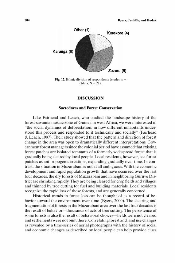
Immigration data are corroborated by information on ethnic affiliationof current residents. A breakdown of the student-and-elder pairs of respon-dents (each pair always of the same ethnic division) by ethnic division isgiven in Fig. 12.
Fig. 5. Responses to “Is it good to respect sacred places?”(students and elders, N = 56).

P1: MRM/RKP P2: MRM
Human Ecology [huec] PP120-300695 April 25, 2001 10:9 Style file version Nov. 19th, 1999
202 Byers, Cunliffe, and Hudak
Fig. 6. Responses to “Why is it good to protect sacred places?” (all responses, N = 52reasons given).
Fig. 7. Responses to “Are there rules about sacred sites?”(students and elders, N = 34).
Fig. 8. Responses to “Do people respect sacred places?” (students and elders, N = 39).

P1: MRM/RKP P2: MRM
Human Ecology [huec] PP120-300695 April 25, 2001 10:9 Style file version Nov. 19th, 1999
Linking the Conservation 203
Fig. 9. Responses to “Who doesn’t respect sacred places?” (students and elderspooled, N = 24 reasons given).
Fig. 10. Responses to “My religious beliefs are:” (students and elders, N = 42).
Fig. 11. Decade of Immigration to Muzarabani (students only,N = 38).
P1: MRM/RKP P2: MRM
Human Ecology [huec] PP120-300695 April 25, 2001 10:9 Style file version Nov. 19th, 1999
204 Byers, Cunliffe, and Hudak
Fig. 12. Ethnic division of respondents (students =elders, N = 21).
DISCUSSION
Sacredness and Forest Conservation
Like Fairhead and Leach, who studied the landscape history of theforest-savanna mosaic zone of Guinea in west Africa, we were interested in“the social dynamics of deforestation; in how different inhabitants under-stood this process and responded to it technically and socially” (Fairhead& Leach, 1997). Their study showed that the pattern and direction of forestchange in the area was open to dramatically different interpretations. Gov-ernment forest managers since the colonial period have assumed that existingforest patches are isolated remnants of a formerly widespread forest that isgradually being cleared by local people. Local residents, however, see forestpatches as anthropogenic creations, expanding gradually over time. In con-trast, the situation in Muzarabani is not at all ambiguous. With the economicdevelopment and rapid population growth that have occurred over the lastfour decades, the dry forests of Muzarabani and in neighboring Guruve Dis-trict are shrinking rapidly. They are being cleared for crop fields and villages,and thinned by tree cutting for fuel and building materials. Local residentsrecognize the rapid loss of these forests, and are generally concerned.
Historical trends in forest loss can be thought of as a record of be-havior toward the environment over time (Byers, 2000). The clearing andfragmentation of forests in the Muzarabani area over the last four decades isthe result of behavior—thousands of acts of tree cutting. The persistence ofsome forests is also the result of behavioral choices—fields were not clearedand settlements were not built there. Correlating forest and land use changesas revealed by a time-series of aerial photographs with the history of socialand economic changes as described by local people can help provide clues
P1: MRM/RKP P2: MRM
Human Ecology [huec] PP120-300695 April 25, 2001 10:9 Style file version Nov. 19th, 1999
Linking the Conservation 205
to the factors that motivate the behaviors that affect forests (Byers, 1996;2000).
The forest fragments now considered sacred were once parts of largercontinuous forests. The whole area of the larger forest blocks may wellhave been considered sacred originally. For example, a descendant of ChiefMuzarabani claims that all of the once-larger Rukonde Forest was sacred,including the southern fragment now called Chikambo Forest. Table I showsthat the amount of forest cleared is dramatically less in forests that are nowconsidered sacred, or were in the past connected to these sacred forests, thanin forests that were not formerly connected to a current sacred forest. Thisresult supports our hypothesis that religious and spiritual values influencebehavior affecting forests.
There are no obvious differences in other ecological and social factorsbetween the forests that were cleared and those that were not. Whetherconsidered sacred or not, these forests are ecologically restricted to old,alluvial soils which local residents say are suitable for agriculture. In this flatregion, the elevation, slope and aspect of sacred and non-sacred forests donot differ in an obvious way. No obvious differences in settlement history,population pressure, or agricultural development near cleared and intactforests stand out.
The history and pattern of forest clearance in Muzarabani strongly sug-gests that traditional religious beliefs have influenced behavior toward thearea’s dry forests. But religious beliefs have not prevented forest loss andfragmentation. Why?
Knowledge of Sacred Sites
Results from the survey taken by Muzarabani students and their eldersprovide useful information for evaluating some hypotheses about behav-iors affecting forests and their underlying motivations. Although the resultspresented here are suggestive, we have sought to exercise caution in theirinterpretation. One limitation of any survey data is that respondents maynot always be telling the truth; another is that responses stating abstractbeliefs or opinions are not always followed up with congruent actions andbehaviors.
Our survey suggested that lack of knowledge about local sacred sites,and about the rules governing them, may play a role in forest loss. For ex-ample, almost half of those surveyed claimed either that they did not knowof sacred places near their village or thought there were none. About halfactually named a nearby sacred site, even though they all lived within afew kilometers of many such sites. Of the respondents who said there were
P1: MRM/RKP P2: MRM
Human Ecology [huec] PP120-300695 April 25, 2001 10:9 Style file version Nov. 19th, 1999
206 Byers, Cunliffe, and Hudak
sacred sites nearby, barely three-quarters claimed to know rules regardingthe proper respect for such places. If taken at face value, these results suggesta significant lack of knowledge about sacred places. However, the apparentlack of knowledge may be partly or mostly the result of the unwillingnessof many people to give such information. Although our data are suggestive,lack of knowledge about sacred places must still be treated as a hypothesis,rather than a finding of this study.
In our interviews with local residents we often heard that people didnot respect sacred places because they did not know about them. Sometimeswe were told that they did not know because they were new immigrants tothe area, and had not yet been told about the local sacred sites. We were alsotold that younger people were now more concerned with economic issues,and were less likely to learn about sacred places, but we were often told thatif someone knew that a place was sacred, they would respect it.
Interviews and community meetings suggested that a lack of knowl-edge of, and agreement about, the exact boundaries of sacred forests maybe important factors leading to their degradation. Local residents have dif-ferent perceptions of the boundaries of sacred forests, and may interpret theboundaries of the “sacred” in ways that suit them. For example, a descendantof Chief Muzarabani claims that all of the once-larger Rukonde Forest wassacred, and that a village located between Rukonde and Chikambo Forestsis actually inside the boundaries of the sacred area. The sabhuku of thatvillage, however, told us that the sacred boundary of Rukonde Forest is wellnorth of his village, and that only about one-half of the present RukondeForest is sacred anyway. He also said that Chikambo Forest, to the southof his village, is not sacred. A member of another family, whose housesand livestock pens encroach into the eastern side of Rukonde, claimed thathis family was given permission to settle there by Chief Muzarabani, andthat where they live is not a part of the sacred forest. So, although a corepart of the forest is considered sacred by everyone, no one believes thatwhere they are living or farming is sacred, even though other local residentsmay.
The ultimate authority on the locations and boundaries of sacred forestswould be the spirit mediums who are thought to speak for the ancestralchiefs of the area. One problem in this case is that two mhondoro spiritswith interests in the Muzarabani area, Nehanda and Chuzu, currently haveno spirit mediums, their previous mediums having died many years ago.The process for identifying and authenticating new mediums is complicated(Lan, 1985), and for both Nehanda and Chuzu new mediums still have notbeen found. The living mediums of other spirits with interests in the area,such as Chiwawa and Chidyamauyu, can make some determinations aboutsacred places in the spirit territories of the medium-less spirits. However,
P1: MRM/RKP P2: MRM
Human Ecology [huec] PP120-300695 April 25, 2001 10:9 Style file version Nov. 19th, 1999
Linking the Conservation 207
people sometimes question the accuracy of their views. The living mediumssometimes refuse to make a decision that is really supposed to be made byanother mhondoro spirit, claiming that only the possessed medium of theappropriate spirit can do so (Spierenburg, 1995). Next to the spirit mediums,chiefs should have the greatest knowledge about sacred places, althoughsome old village heads may know the locations and boundaries of sacredforests better than young chiefs.
Traditional Religious Values and Forest Conservation
Survey respondents gave three reasons, other than lack of knowledge,why some people did not respect traditional sacred places: because of theirreligion, their age, or the fact that they were immigrants (Fig. 9). The mostcommon reason given was that people who didn’t respect traditional sacredplaces were Christian (50%). However, roughly three-quarters of the re-spondents described their beliefs as “both mhondoro religion [traditionalShona religion] and Christian,” while only six of 42 respondents said theywere “Christian only.” If degradation of sacred forests were in fact causedby those considering themselves Christian only, it would have to be causedby fewer than 15% of the local population. The majority of respondents whogave their religion as “Christian only” (4/6) nevertheless said it was good torespect traditional sacred places. These data call attention to the fact thata large majority of local people say they are followers both of traditionalShona religion and Christianity. They do not lend support to the hypothesisthat Christianity is the cause of forest loss.
The second most common reason given by survey respondents was thatpeople who didn’t respect traditional sacred places were young (37.5%).However, there were no statistically significant differences between studentsand elders in response to the question “Is it good to respect sacred places?”Our data therefore do not support the hypothesis that young people areresponsible for a lack of respect for sacred forests, although again we shouldnote that survey results should be interpreted with caution.
The third reason given by respondents on the survey was that peoplewho didn’t respect traditional sacred places were immigrants (12.5%). How-ever, as shown in Fig. 11, only a small minority of the residents of the area arenot immigrants, and yet about 85% say it is good to respect sacred places.We were told in interviews that immigrants would usually respect sacredplaces if they knew about them. In several cases, old immigrants now appearto play strong roles in protecting sacred forests and upholding traditionalrules governing their use. The survey and interview information we obtainedtherefore does not unambiguously support or refute the hypothesis that

P1: MRM/RKP P2: MRM
Human Ecology [huec] PP120-300695 April 25, 2001 10:9 Style file version Nov. 19th, 1999
208 Byers, Cunliffe, and Hudak
immigration has resulted in a loss of respect for sacred forests, and the roleplayed by immigration is not clear.
In summary, the results of the survey do not unambiguously support anyof the three reasons given by respondents for lack of respect for traditionalsacred sites in the area: neither religion, nor age, nor immigrant status seemsto clearly explain a lack of respect for sacred forests in Muzarabani.
Spirit mediums are the authorities ultimately responsible for protectingsacred sites and enforcing rules about their use. As population increases, theinfluence of the spirit mediums is diluted. People used to have much morefrequent contact with spirit mediums. Mediums too are changing, behavingin ways that cause them to lose some of their traditional influence. Somenow ride on buses, use fertilizer, and live in “four-cornered” houses, all ofwhich were thought in the past to compromise their power and authenticity(Lan, 1985). In short, the system of spirit mediums is under stress, and isexperiencing difficulty adapting to the rapid demographic and economicchanges in Zimbabwe.
Material and Nonmaterial Values in the Shona Worldview
Our results show that traditional spiritual values have motivated theconservation of some of the dry forests in Muzarabani up to now. This callsinto question simplistic claims that people can only be motivated to con-serve natural resources if they get direct material or “economic” benefitsfrom doing so. The reasons given by local residents about why it is goodto respect sacred forests (see Fig. 6) can be thought of as perceived values,benefits, and uses of those forests. While some of the values and uses areclearly nonmaterial—such as preserving culture—others—such as protect-ing animals, trees, and medicinal plants—are material. Still others amongthe reasons given for protecting sacred forests could be seen as either ma-terial or nonmaterial, depending upon whether one’s perspective is insideor outside the belief system of Shona religion. To a nonbeliever, protectingsacred sites to bring rain or prevent punishment by spirits would be seen asnonmaterial, spiritual values. To a believer, however, rain and disease (onekind of punishment by spirits) are real and material, so the benefits of respectfor sacred forests would be viewed as direct material values.
In this case we may question whether the distinction, which seems soreal from a Western worldview, between nonmaterial (e.g., spiritual and re-ligious) benefits and material (e.g., food, water, health) benefits is perceivedas a real distinction by those who believe in Shona religion. To believers inthe mhondoro, it is those ancestral spirits who bring the annual rains andmaintain the fertility of the land. If the mhondoro require that their sacred

P1: MRM/RKP P2: MRM
Human Ecology [huec] PP120-300695 April 25, 2001 10:9 Style file version Nov. 19th, 1999
Linking the Conservation 209
places be respected, then those places—although not cleared or farmed—areperceived to be directly beneficial in a material and economic sense. Theirprotection in a natural state is believed to indirectly produce food, health,and other material benefits for people.
Disempowerment of Traditional Leaders and Forest Conservation
Our data (see Table I) show a dramatic difference in forest loss eastand west of the Musengezi River. The correlation between a higher level offorest loss and the implementation of the Mid-Zambezi Rural DevelopmentProject on the west side of the Musengezi supports a hypothesis that links for-est conservation with the power of traditional political and religious leaders.
The Mid-Zambezi Project began in 1987. The goals of this project, whichwas funded by the African Development Bank and Zimbabwean govern-ment, included resettling local residents in newly created or reorganized nu-clear villages, providing land for the resettlement of 3,000 farming familiesfrom other communal areas, and increasing agricultural production, espe-cially of commercial cash crops (Derman, 1996; Spierenburg, 1995). Usinga technocratic, top-down approach, land use mapping and planning werecarried out by Agritex, the national agricultural extension service. Modernpolitical authorities—District Councils, ward councilors, Ward DevelopmentCommittees (WADCOs) and Village Development Committees (VIDCOs)had to implement these plans. “Traditional authority . . .was bypassed. Nolonger were the chief, mhondoros [spirit mediums], and sabhukus asked orinformed about new residents in their territories . . .The diminution of localauthority is also fostered by residents (usually migrants) who do not acceptold leadership and who can legitimately claim that they do not fall under cus-tomary authorities but rather under the WADCOs and VIDCOs” (Derman,1996).
The forest change we observed in aerial photos began at least twodecades before the Mid-Zambezi Project, so factors other than the disem-powerment of traditional leaders may have also contributed to the differentrates of forest loss east and west of the river. Population pressure for landdoes not seem to provide an alternative explanation, however. Populationdensity of Gutsa Ward, on the west side of the Musengezi, was estimated at0.4 people per square kilometer in 1962, and in adjacent Muzarabani Wardon the east side of the river at 2.8 people per square km. In 1969, after theGutsa irrigation scheme had been developed, population density in GutsaWard was estimated to be 2.4 per square km, and in Muzarabani to be 3.9 persquare km. Population density probably remained higher on the east sideof the river even in 1982 (Cunliffe, 1992). Although localized population
P1: MRM/RKP P2: MRM
Human Ecology [huec] PP120-300695 April 25, 2001 10:9 Style file version Nov. 19th, 1999
210 Byers, Cunliffe, and Hudak
density estimates are difficult to make, and should be interpreted cautiously,it appears that population densities in the study area were higher east of theMusengezi for 25 years before the Mid-Zambezi project, but rates of forestclearance were significantly less.
The Mid-Zambezi Project was originally intended to be completed by1992, but it was behind schedule due in part to technical and organizationalproblems, and was extended until 1995. Increasing local resistance, whichinvolved spirit mediums and other traditional religious leaders, slowed theimplementation of the project as it moved eastward into the Muzarabaniarea (Spierenburg, 1995). The relocation of people into centralized villages;demarcation of homesteads, crop fields, and grazing lands; and resettlementthat the project carried out on the west side of the Musengezi River did notoccur on the east side of the Musengezi because of this local resistance. A“which came first, the chicken or the egg” problem complicates the analysisof this situation. Traditional leaders may have been relatively less powerfulon the west side of the Musengezi than on the east side in the decades before1987, thus allowing the Mid-Zambezi Project to develop momentum and beimplemented west of the river, but stall and not be implemented east of theriver (Derman, 1996; Spierenberg, 1995). The relatively greater power oftraditional political and religious leaders east of the Musengezi may havebeen maintained over several decades, and may explain the significantlylower level of forest loss on that side of the river.
At a community meeting, one village head said: “As a sabhuku, I amquite aware that there are some sacred areas near my village. But it lookslike the power to protect those sacred places was taken from the sabhukusand given to the VIDCO chairmen. That is exactly when the destruction ofthese resources started, when powers were withdrawn from sabhukus. Somepeople were allocated land, and sacred areas were pegged off [reserved fromcultivation]. But when these people realized village heads were powerless tostop them, they cultivated those sacred areas anyway.” Another local leadercalled the tension between VIDCO chairmen and sabhukus a “ tug-of-war.VIDCO chairmen were given political powers—but they don’t know aboutthe sacred areas here.” The tension between modern political leaders andtraditional political and religious leaders has roots which go back to thecolonial period (Lan, 1985).
LINKING PROTECTION OF SACRED SITES WITHCONSERVATION OF FORESTS AND WILDLIFE
Because traditional religious values appear to have motivated forestprotection in Muzarabani, and because the power of traditional leaders

P1: MRM/RKP P2: MRM
Human Ecology [huec] PP120-300695 April 25, 2001 10:9 Style file version Nov. 19th, 1999
Linking the Conservation 211
seems to be related to rates of forest loss, we conclude that in order toconserve forests in Muzarabani, a strategy that links the conservation ofculture and nature is more likely to be effective than a strategy that ignorestraditional beliefs, values, and institutions. We will now discuss some ideasfor supporting and strengthening traditional values and institutions and im-proving forest conservation at the same time.
Empowering Traditional Leaders in the Modern System
The Zambezi Society presented the results of the 1995–96 botanicalsurvey and prioritization exercise to representatives of each of the six RuralDistrict Councils in the Zambezi Valley in 1996, and assessed their interestin working to conserve high-priority sites in their districts. In Muzarabani,representatives of the Rural District Council proposed that the best way toconserve the remaining dry forests of the area was to involve traditional lead-ers and to strengthen respect for customary rules and traditions regardingforest use. This strategy of working directly with the traditional leadershipto reinforce customary laws for forest conservation provides an interest-ing contrast to the other districts, in which modern legal approaches wereproposed, such as passing by-laws at the district level to create botanical pro-tected areas (Timberlake & Cunliffe, 1997). As discussed earlier, however,there is ambiguity about who has the power to make and enforce land usedecisions—traditional or modern leaders. Although the authority to allocateland for various uses legally rests with modern political leaders, in practicetraditional leaders often make these decisions. There is a tension betweenthe two systems in this regard.
Traditional leaders are often impotent to enforce customary rules whennot supported, or especially when actively opposed, by modern politicalleaders. In one case, for example, two brothers have cleared crop fields andare plowing within the boundaries of the Kapara Forest. In this case wewere told that a relatively low-level modern leader, a ward councilor, gavethem permission to do so, and even the traditional chief of the area does notseem to be willing or able to stop them. The Mid-Zambezi Rural Develop-ment Project helped to create this tension between modern and traditionalleaders.
It is fairly common for the same individual to have roles in both thetraditional and modern systems. One man we interviewed, for example, wasboth a sabhuku and a mutapi in the traditional system—both a traditionalpolitical and religious leader, in other words—as well as an elected wardcouncilor and the chairman of the District Wildlife Committee in the post-independence political system. Individuals like this can be key leaders in

P1: MRM/RKP P2: MRM
Human Ecology [huec] PP120-300695 April 25, 2001 10:9 Style file version Nov. 19th, 1999
212 Byers, Cunliffe, and Hudak
harmonizing the values of the traditional and modern systems, and in linkingthe conservation of culture and nature.
Increasing Awareness and Knowledge of Sacred Sites
At a community meeting some residents asked whether signs or mark-ers could be placed to identify the boundaries of sacred forests. In responsea traditional leader replied that “as far as putting up signs goes, we have toleave that to the chiefs, because we don’t want to do anything that is for-bidden by the mhondoro.” The local chief, Headman Muzarabani, basicallyrejected the idea of signs, saying that “Some people might recommend paint-ing trees to mark the boundaries, but you need to learn the boundaries, notmark them with paint.”
The sabhuku of a village near Rukonde Forest told us that he thoughtthe entire forest should be fenced “with wire” to protect it. At a communitymeeting a participant asked “Can’t we fence these sacred areas?” He pointedout, however, that “if we did, how would the elephants get in and out?” Atraditional leader spoke against fencing, saying “Spirits don’t want areas tobe fenced; they don’t like wire.” The local chief, Headman Muzarabani, hadthe last word on fencing sacred areas, as he had on marking them with signs:“You people should be the fence, not wire.”
In response to both of these ideas the chief seemed to be saying thatpeople must learn the boundaries of sacred areas and respect them, ratherthan being informed by signs and kept out by fences. He said he would holdmeetings in villages throughout the area to make sure people knew the lo-cations and boundaries of sacred forests. A traditional leader recommendedthat village heads take a trip around the area with village residents to showthem the boundaries of sacred areas.
These proposals raise the question of whether non-local organizationslike the Zambezi Society can do anything to help local leaders increaseawareness and knowledge of the sacred forests in their area, and clarify thelocation of their boundaries. One role for outsiders might be to facilitatemeetings of local residents (by assisting with transportation and food, forexample) at which the locations and boundaries of sacred forests, and op-tions for their conservation, could be discussed. Outside organizations mightalso facilitate trips to enable local residents to visit sacred sites and discussboundaries, as well as develop and provide maps of sacred forests (and/orother sacred sites) as part of a campaign to increase knowledge and aware-ness of these areas, if desired and approved by local leaders. A caveat shouldbe added, however. One of the adaptive features of traditional governance isits flexibility, and in Shona religion the “sacredness” of a place can be added
P1: MRM/RKP P2: MRM
Human Ecology [huec] PP120-300695 April 25, 2001 10:9 Style file version Nov. 19th, 1999
Linking the Conservation 213
or removed as needed for effective social and environmental management(Schoffeleers, 1978; Spierenburg, 1995; Y. Mhene, pers. comm.). Some peo-ple or groups may claim that a site is “sacred” in order to reserve it for theirown future use (Dzingirai & Bourdillon, 1998). Printed maps may reduce thistraditional flexibility by “freezing” sacred geography. The potential cost ofdoing so must be weighed carefully against the problem of lack of knowledgeand agreement about the boundaries of sacred sites, which maps could clarify.
An important step toward empowering traditional leaders with respectto land use decisions involving sacred forests and other areas is to informmodern political leaders—District-level officials, District Council members(the ward councilors), and chairmen of the WADCOs and VIDCOs—of thelocations and boundaries of sacred sites. In doing so, however, the caveatmentioned above regarding the potential benefit of the traditional flexibilityof “sacredness” should be kept in mind.
Knowledge that a place is considered sacred may not be enough to pro-tect it in every case. In interviews and at community meetings, village headsand other traditional leaders pointed out cases in which they believed peopleknew a place was sacred, but cut trees, planted crops, or violated the rulesanyway. People who knew a place was sacred but did not respect customaryrules about its proper use were described as “rude” or “mischievous.” Situ-ations like this require understanding the many factors besides knowledgethat can influence environmental behavior (Byers, 1996; 2000).
Managing Forests for Multiple Values and Uses
The sacred forests of Muzarabani contribute to livelihoods and qualityof life at the local level, the district level, and the national level because ofthe many material and nonmaterial uses, values, and benefits they provide.The compatibility of many of these uses could allow a diverse group of stake-holders to recognize their common interest in conserving the Muzarabanidry forests, and encourage them to cooperate to do so.
Local people are generally sincere in their traditional religious beliefs,and have a strong desire to preserve their culture. Cultural respect requiresunderstanding that in Shona religion there is no clear dichotomy betweennonmaterial spiritual uses and material economic ones. The Shona religiousbelief that the ancestral spirits who look after the welfare of contemporarypeople reside in wild animals is a positive force for environmental conserva-tion. Those wild animals require undisturbed natural habitat, so this beliefleads to the protection of natural habitats. If these traditional beliefs dieout, one factor favoring the conservation of natural areas will be lost. Man-aging the Muzarabani forests for sustainable uses requires that traditional

P1: MRM/RKP P2: MRM
Human Ecology [huec] PP120-300695 April 25, 2001 10:9 Style file version Nov. 19th, 1999
214 Byers, Cunliffe, and Hudak
religious uses be recognized as legitimate uses, and be respected. Implement-ing such recognition of, and respect for, traditional values may require thedevelopment of new policy guidance for government and/or donor agenciesand institutions involved in natural resources management.
In addition to their religious values and uses, the forests of Muzarabaniprovide direct, material benefits and earn money for the district through theCAMPFIRE sport hunting concession. The current hunting concessionairesaid that he deliberately guides hunters to the forest areas because theyattract wildlife (J. Meyer, pers. comm.). Local people, including traditionalleaders, recognize the economic value of the dry forests as wildlife habitat.At a public meeting the chief of the area said “We are getting money fromCAMPFIRE [because of elephants that stay in those areas], and we won’tif they [those people] keep destroying those areas.” A local sabhuku said:“We are lucky to have these forests. CAMPFIRE gets lots of money fromthe elephants that stay here.”
Hoare and Du Toit (1999) reported that elephants and humans cancoexist in areas with significant human population densities and surprisinglyhigh levels of conversion of natural vegetation to agricultural fields. Theysuggest that elephant populations can persist where human settlement isinterspersed with a matrix of untransformed natural habitat, and that the sizeand connectivity of the patches of natural habitat is the critical determinantof whether elephants will remain or move away. For the time being, theforests of Muzarabani provide the natural habitat required to attract andmaintain elephants in the area.
The dry forests of Muzarabani have a high scientific value accordingto the Zambezi Society. They are useful to scientists as a good example ofone of the natural vegetation types of Zimbabwe and the Zambezi Valley,and could be called “witness stands” or “benchmark sites” of this plantassemblage (Timberlake & Cunliffe, 1997). As such they can help providea baseline against which environmental change can be measured, whetherthat change is natural or anthropogenic, long or short term. These forestsmay be relicts from the Pleistocene, when the climate of the Zambezi Valleywas different than now. They could be helpful in understanding long-termclimate change in this part of Africa. They also provide seed sources forlocally adapted populations of their constituent species, and thus keep openthe option of future restoration of these forests.
A potential threat to the sacred forests of Muzarabani is that decisionsmade elsewhere may overwhelm local conservation actions. Muzarabani’sdry forests could be adversely affected by irrigation or resettlement schemes,or by changes in the economics of cotton cultivation in Zimbabwe, for exam-ple. The more common interests that exist among the diverse stakeholders

P1: MRM/RKP P2: MRM
Human Ecology [huec] PP120-300695 April 25, 2001 10:9 Style file version Nov. 19th, 1999
Linking the Conservation 215
in forest conservation in Muzarabani, the better able these stakeholders willbe to fight against outside pressures that would destroy the forests.
CONCLUSIONS: LESSONS FROM MUZARABANI
Out of this study of the sacred forests of Muzarabani come some lessonswith wider applicability:
• Using an environmental history approach can provide insights aboutthe motivations of environmental behaviors. Relating forest and landuse changes revealed by aerial photographs to the history of social andeconomic changes as described by local people provided insights intothe factors that influence and motivate behaviors that affect forests.• Spiritual or religious values can motivate conservation of natural re-
sources. In this case, the amount of forest cleared is dramatically lessin forests that are now considered sacred, or were in the past con-nected to these sacred forests, than in forests that were not formerlyconnected to a current sacred forest.• The degree of empowerment of traditional leaders within the modern
system of government can influence conservation that is motivatedby traditional values and practices. Policies that support traditionalinstitutions and empower traditional leaders can foster conservationin such cases.• Strengthening knowledge of, and respect for, traditional sacred sites
has significant potential for conserving forests and wildlife in casessuch as that discussed here.• Nonmaterial uses of nature should be recognized as legitimate uses.
Policies that recognize and respect values and uses of forests otherthan strictly material and economic ones can enhance conservation.• Traditional spiritual uses of forests as sacred places and modern eco-
nomic uses of forests as wildlife habitat are potentially compatible. Asynergy of traditional nonmaterial and modern material values anduses creates the potential for a “win-win” situation that could leaddiverse stakeholders to cooperate to conserve natural resources.• The dichotomy between material and nonmaterial uses that is con-
sidered so real and clear from a modern, Western perspective is notnecessarily perceived as a dichotomy in other cultures. For adherentsof Shona religion, protecting sacred forests as habitat for wild animalsinhabited by ancestral spirits is believed to bring tangible, materialbenefits: it makes the rain fall and the soil productive for growing food.
P1: MRM/RKP P2: MRM
Human Ecology [huec] PP120-300695 April 25, 2001 10:9 Style file version Nov. 19th, 1999
216 Byers, Cunliffe, and Hudak
• Outsiders and non-local organizations can potentially play a catalyticrole in conserving both culture and nature. Our experience in Muzara-bani has convinced us that the presence of outsiders who are inter-ested in traditional culture and sacred places can catch the attentionof local people, and of traditional and modern leaders. Interest fromoutsiders may shift power balances so that traditional leaders strug-gling to protect the traditional culture, including traditional sacredsites, have more leverage.
ACKNOWLEDGMENTS
We wish to thank the many residents of Muzarabani who took time toanswer our questions and show us their forests, especially Crispen Honde,Yeduram Mhene, Alfred Masawi, and Albert Warambwa, and also manymembers of the Muzarabani Rural District Council who joined us at com-munity meetings. We acknowledge a special debt to Phanuel Rupiya forgathering information about sacred sites in the Muzarabani area, and toChristopher Mugari for assisting with the written survey given to his stu-dents and their elders. The first author wishes to thank the U.S. InformationAgency and the Center for International Exchange of Scholars for makingthis research possible through a senior Fulbright Scholarship that enabledhim to spend a year at the Centre for Applied Social Sciences, University ofZimbabwe. Support from the Zambezi Society and its Executive Director,Dick Pitman, is gratefully acknowledged. We also thank three anonymousreviewers, whose suggestions strengthened the paper.
REFERENCES
Bourdillon, M. F. C. (1987). Shona Peoples. Mambo Press, Gweru, Zimbabwe.Brown, M., and Wyckoff-Baird, B. (1992). Designing Integrated Conservation and Development
Projects. Biodiversity Support Program, Washington, DC.Byers, B. A. (1996). Understanding and Influencing Behaviors in Conservation and Natural
Resources Management. Biodiversity Support Program, Washington, DC.Byers, B. A. (2000). Understanding and Influencing Behaviors: A Guide. Biodiversity Support
Program, Washington, DC.Child, B. (1996). The practice and principles of community-based wildlife management in Zim-
babwe: The CAMPFIRE programme. Biodiversity and Conservation 5: 369–398.Child, G. (1996). The role of community-based wild resource management in Zimbabwe. Bio-
diversity and Conservation 5: 355–367.Cunliffe, R. N. (1992). An Ecological Resource Survey of the Communal Lands of Centenary
District. WWF Multispecies Animal Production System Project, Project Paper No. 26,Oct. 1992. WWF-World Wide Fund for Nature, P.O. Box CY 1409, Causeway, Harare,Zimbabwe.
P1: MRM/RKP P2: MRM
Human Ecology [huec] PP120-300695 April 25, 2001 10:9 Style file version Nov. 19th, 1999
Linking the Conservation 217
Derman, B. (1996). Changing Land-Use in the Eastern Zambezi Valley: Socio-Economic Con-siderations. CASS-WWF Joint Paper. Centre for Applied Social Sciences, University ofZimbabwe, P.O. Box MP 167, Mount Pleasant, Harare, Zimbabwe.
Dorm-Adzobu, C., Ampadu-Agyei, O., and Veit, P. G. (1991). Religious Beliefs and Environ-mental Protection: The Malshegu Sacred Grove in Northern Ghana. From the GroundUp Case Study No. 4, Center for International Development and Environment, WorldResources Institute, Washington, DC.
Dzingirai, V., and Bourdillon, M. F. C. (1997). Religous ritual and political control in BingaDistrict, Zimbabwe. African Anthropology 4(2): 4–26.
Fairhead, J., and Leach, M. (1997). Misreading the African Landscape: Society and Ecology ina Forest-Savanna Mosaic. Cambridge University Press, Cambridge, UK.
Fearnside, P., and Ferraz, J. (1995). A conservation gap analysis of Brazil’s Amazonian vegeta-tion. Conservation Biology 9: 1134–1147.
Hoare, R. (1998). Muzarabani Elephant Research and Monitoring: Interim Report, Decem-ber 1998. Report prepared for the Muzarabani Rural District Council on behalf of theMuzarabani Elephant Project and the Zambezi Society.
Hoare, R. E., and Du Toit, J. T. (1999). Coexistence between people and elephants in Africansavannas. Conservation Biology 13: 633–639.
Hughes, D. M. (1995). Community-Based Forest Management in the Lucite (Rusitu) Valley:People and Policies of a Proposed Mozambique-Zimbabwe Transfrontier ConservationArea. Consultant’s Report for the The World Bank, Maputo, Mozambique.
Keel, S., Gentry, A. H., and Spinzi, L. (1993). Using vegetation analysis to facilitate the selectionof conservation sites in eastern Paraguay. Conservation Biology 7: 66–75.
Khan, M. L., Menon, S., and Bawa, K. S. (1997). Effectiveness of the protected area network inbiodiversity conservation: a case-study of Meghalaya state. Biodiversity and Conservation6: 853–868.
Kiester, A., Scott, J. M., Csuti, B., Noss, R. F., Butterfield, B., Sahr, K., and White, D. (1996).Conservation prioritization using GAP data. Conservation Biology 10: 1332–1342.
Lan, David. (1985). Guns and Rain: Guerillas and Spirit Mediums in Zimbabwe. James CurryLtd: London and University of California Press, Berkeley and Los Angeles, California.
Maphala, J. M. (1994). Customary woodland management practices in Gokwe. In Clarke,J. (ed.), Building on Indigenous Natural Resource Management: Forestry Practices inZimbabwe’s Communal Lands. Forestry Commission of Zimbabwe, P.O. Box HG 595,Highlands, Harare, Zimbabwe, pp. 12–14.
Metcalfe, S. (1994). The Zimbabwe Communal Areas Management Program for IndigenousResources (CAMPFIRE). In Western, D., and Wright, R. M. (eds.), Natural Connec-tions: Perspectives in Community-based Conservation. Island Press, Washington, D.C. andCovelo, California, pp. 161–192.
Murphree, M. W. (1994). The role of institutions in community-based conservation. In Western,D., and Wright, R. M. (eds.), op. cit., pp. 403–427.
Musvoto, C. (1994). Resource use and management in Jinga Village. In Clark, J., op. cit., pp.15–19.
Muzarabani Rural District. (1995). CAMPFIRE Programme 1995 Annual Report. Muzarabani,Zimbabwe.
Ntiamoa-Baidu, Y. (1995). Indigenous vs. introduced biodiversity conservation strategies: thecase of protected area systems in Ghana. African Biodiversity Series Number 1, May 1995.Biodiversity Support Program, Washington, DC.
Omari, C. K. (1990). Traditional African land ethics. In Engel, J. R., and Engel, J. Gibb (eds.),Ethics of Environment and Development: Global Challenge, International Response. Uni-versity of Arizona Press, Tucson, Arizona, pp. 167–175.
Peres, C. A., and Terborgh, J. W. (1995). Amazonian nature reserves: an analysis of the defensi-bility status of existing conservation unites and design criteria for the future. ConservationBiology 9: 34–46.
Reid, W. V. (1996). Beyond protected areas: changing perceptions of ecological managementobjectives. In Szaro, R. C., and Johnson, D. W., op cit., pp. 442–453.

P1: MRM/RKP P2: MRM
Human Ecology [huec] PP120-300695 April 25, 2001 10:9 Style file version Nov. 19th, 1999
218 Byers, Cunliffe, and Hudak
Schoffeleers, J. M. (ed.). (1978). Guardians of the Land: Essays on Central African TerritorialCults. Mambo Press: Harare, Zimbabwe.
Soule, M. E., and M. A. Sanjayan. (1998). Conservation targets: Do they help? Science 279,2060–2061.
Spierenburg, M. (1995). The Role of the Mhondoro Cult in the Struggle for Control over Land inDande (Northern Zimbabwe): Social Commentaries and the Influence of Adherents. CASSOccassional Paper—NRM Series; 1995. Centre for Applied Social Sciences, University ofZimbabwe, P.O. Box MP 167, Mount Pleasant, Harare, Zimbabwe.
Surveyor-General. (1995). Mhangura, Sheet SE-36–1. Topographic map from Office of theSurveyor-General of Zimbabwe, P.O. Box CY 540, Causeway, Harare, Zimbabwe.
Szaro, R. C., and Johnson, D. W. (eds.). (1996). Biodiversity in managed landscapes. Theory andpractice. Oxford University Press, Oxford and New York.
Timberlake, J., and Cunliffe, R. N. (1997). Sites of Interest for Botanical Conservation in theCommunal Lands of the Zambezi Valley, Zimbabwe. Consultant’s Report for The ZambeziSociety. The Zambezi Society, P.O. Box HG 744, Highlands, Harare, Zimbabwe.
Timberlake, J. R., Nobanda, N., Mapaure, I., and Mabasa, L. (1991). Sites of Interest for Con-servation in Various Communal Lands of N. and W. Zimbabwe. Report No. 1, CommunalLands Vegetation Survey. National Herbarium, Harare, Zimbabwe. 16 pp.
Wells, M., Brandon, K., and Hannah, L. (1992). People and Parks: Linking Protected AreaManagement with Local Communities. The World Bank, World Wildlife Fund, and U.S.Agency for International Development, Washington, DC.
Zambezi Society. No date. The Muzarabani Experience. Number 3 of a series of occasionalBackgrounder Papers. The Zambezi Society. The Zambezi Society, P.O. Box HG 744,Highlands, Harare, Zimbabwe.