Linking environmental models together to make the world a better place: the GIS approach
45
Linking environmental models together to make the world a better place: the GIS approach Geoinformatics FCE CTU Prague, Czech Republic, 19th of May 2011 Andrea Antonello (HydroloGIS) Olaf David (Colorado State University/USDA)
-
Upload
andrea-antonello -
Category
Technology
-
view
2.185 -
download
0
Transcript of Linking environmental models together to make the world a better place: the GIS approach

Linking environmental models together tomake the world a better place: the GIS
approach
Geoinformatics FCE CTUPrague, Czech Republic, 19th of May 2011
Andrea Antonello (HydroloGIS)Olaf David (Colorado State University/USDA)

The importance of being... GIS
a container for environmental sciences...
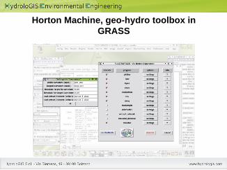
Horton Machine, geo-hydro toolbox inGRASS

JGrass, hydro-geomorphology based onGRASS formats
• first wanted to be a userfriendly gui for GRASS
• a toolbox for geomorphology and hydrology
Soon it became clear what was missing to make the world
a better place:
• a standard (accepted) modelling system
• a modern, mature and extensible rich client
framework

uDig, the GIS app to create apps

...the glue for different applications?
The reciepe so far:
• GIS
• a fair amount of
science
• ?

What do we mean when we say linkingmodels?
A simple example
ESRI ASCII, TIF, GRASS COVERAGE READER PITFILLER
ESRI ASCII, TIF, GRASS COVERAGE WRITER

Still a simple example
ESRI ASCII, TIF, GRASS COVERAGE READER PITFILLER
ESRI ASCII, TIF, GRASS COVERAGE WRITERFLOWDIRECTIONS

Still a simple example, but trickier
ESRI ASCII, TIF, GRASS COVERAGE READER PITFILLER
ESRI ASCII, TIF, GRASS COVERAGE WRITERFLOWDIRECTIONS
ESRI ASCII, TIF, GRASS COVERAGE WRITER
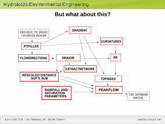
But what about this?
RESCALED DISTANCE SUP E SUB
ESRI ASCII, TIF, GRASS COVERAGE READER
PITFILLER
FLOWDIRECTIONS DRAIDIR
EXTRACTNETWORK
GRADIENT
CURVATURES
AB
TOPINDEX
PEAKFLOWRAINFALL AND SATURATION PARAMETERS
CSV, DATABASE WRITER
And this?
CSV, DATABASE READER
ENERGY INDEX
KRIGINGrain interpolation
ENERGY BALANCE
SNOW, GLACIER VEGETATION PARAMETERS
CSV, DATABASE WRITER
Pnet, SWE
SHAPEFILE AND POSTGIS READER
tem
pera
ture
pre
ssure
rela
tive h
um
idity
win
d s
peed
rain
basinsrain gauges basins
meteo stations
rain
tem
pera
ture
pres
sure
rela
tive
hum
idity
win
d sp
eed
basins
JAMI other meteointerpolation

And then there is time
Consider there will be parameters and modules that execute just once, theremight be an external timeline, which could even be paused when no data areavailable.
CSV, DATABASE READER
ENERGY INDEX
KRIGINGrain interpolation
ENERGY BALANCE
SNOW, GLACIER VEGETATION PARAMETERS
CSV, DATABASE WRITER
Pnet, SWE
SHAPEFILE AND POSTGIS READER
tem
pera
ture
pre
ssure
rela
tive h
um
idity
win
d s
peed
rain
basinsrain gauges basins
meteo stations
rain
tem
pera
ture
pres
sure
rela
tive
hum
idity
win
d sp
eed
basins
JAMI other meteointerpolation
t
1x calc
pause dt 1x param

What other problems do we have for a modellingenvironment to work?
• modules come from different authors
• modules come in different.. ehm flavours
• nowadays it should be possible to load library
modules at runtime
• they should not change the original code too much
• to be able to connect them, the modules need to be
datatype abstract
• ...and possibly have the timeline external

What do we mean when we say linking models?
DATA READER MODULE 1 DATA WRITER
inputFilePathForModule1 outputFilePathOfModule1
DATA READER MODULE 2 DATA WRITER
t1...tn t1...tn
DATA READER
MODULE 1
DATA WRITER
inputFilePathForModule1 outputFilePathOfModule1
t1MODULE 2
tn

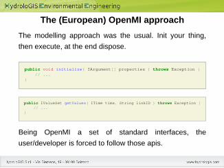
The (European) OpenMI approach
Considering that:
• OpenMI seemed to become de facto a standard (still)
• important actors in hydrology (ex. DHI and Deltares)
• OpenMI was missing GIS notions
We decided to:
• invest two years to migrate our modules to that
framework
• invest time and resources to join the technical
steering committee
The (European) OpenMI approach
The modelling approach was the usual. Init your thing,
then execute, at the end dispose.
public void initialize( IArgument[] properties ) throws Exception { // ...}
public IValueSet getValues( ITime time, String linkID ) throws Exception { // ...}
Being OpenMI a set of standard interfaces, the
user/developer is forced to follow those apis.

The (European) OpenMI approach
We learned that:
• for our purposes the framework was too invasive (for
large models than many small modules?)
• migration effort was too big
• by the time we finished a new major release was
ready
• at that time we were the only ones supplying open
source modules (so who to test linking with?)
• back then we never were able to get GIS stuff into
OpenMI (now they discuss with OGC)
The (American) OMS3 approach
At a conference our team came in touch with the Object
Modelling System.
Welcome to the Object Modeling System ... modeling
framework ... based on components ... project active
among the U.S. Department of Agriculture and partner
agencies ... highly inter-operable and lightweight
modeling framework for component-based model and
simulation development on multiple platforms.
Well, we had heared that before.

Annotations on your code
Basically OMS3 supplies a set of Annotations to put on
the code to describe it.
Class description useful for the generation of
documentation and guis.
@Description("It fills the depression points present within a DEM.")@Documentation("Pitfiller.html")@Author(name = "David Tarboton")@Keywords("Dem manipulation, Geomorphology, DrainDir")@Label(JGTConstants.DEMMANIPULATION)@Name("pit")@Status(Status.CERTIFIED)public class Pitfiller { // ...}

Definition and description of input and output parameter
@Description("The map of digital elevation model (DEM).")@Inpublic GridCoverage2D inElev;
@Description("The depitted elevation map.")@Outpublic GridCoverage2D outPit = null;
Definition of the method to be executed
@Executepublic void process() throws Exception { // ...}

What about native code?
How does OMS3 help?
• Use FORTRAN code in OMS directly (no C/C++
bridge required)
• Define OMS components in FORTRAN
• Integrated with build system
• Allow automatic documentation generation from
source

Requirements?
• FORTRAN 90+ syntax
• ISO_C_BINDING
• GCC 4.4+ / gfortran
! @ExecuteSUBROUTINE we(eroout, eroout_len,runoff,peakro,effdrn)
! @In CHARACTER(kind = C_CHAR, len = eroout_len) :: eroout INTEGER(C_INT), intent(in), VALUE :: eroout_len
! @In REAL(C_FLOAT) :: runoff,peakro,effdrn ..
http://gcc.gnu.org/onlinedocs/gfortran/ISO_005fC_005fBINDING.html

OpenMI vs. OMS3: our experience

Extending OMS3 with GIS: the genesis ofJGrasstools
OMS3 brought some important advantages:
• USDA has lots of open source OMS3 modules
• flat learning curve for instant gratification
• fast migration of code
• abstraction of I/O is perfect choice, clean code
• possibility of external handling of the timeline
We decided to not migrate JGrass to use OMS3, but
instead to extract the processing algorithms to a
geomorphologic and hydrologic library, the
JGrasstools.

What can we find in JGrasstools?
Engineering
Major environmental models:
• hydro-geomorphological risk
• hydropower, solar potential and renewable energies
• LiDAR data analysis

Maximum discharge: Peakflow
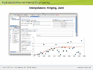
Interpolators: Kriging, Jami

Full hydrological cycle: Adige, Hymod
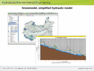
Snowmodel, simplified hydraulic model

Network Management
Powerful and well known software for water supply
system and stormwater network system design and
maintainance:
• Epanet
• Trento_p
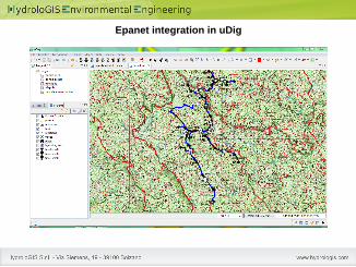
Epanet integration in uDig
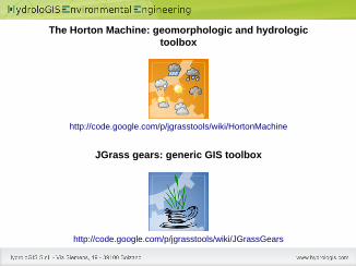
The Horton Machine: geomorphologic and hydrologictoolbox
http://code.google.com/p/jgrasstools/wiki/HortonMachine
JGrass gears: generic GIS toolbox
http://code.google.com/p/jgrasstools/wiki/JGrassGears

How to use JGrasstools
• in applications (see Epanet for uDig)
• through the scripting engine (groovy, oms, geoscript)
sim = new oms3.SimBuilder(logging:'ALL').sim(name:'pitfiller') { model { components { 'pitfiller' 'pit' 'reader' 'rasterreader' 'writer' 'rasterwriter' } parameter { 'reader.file' 'D:\\data\\spearfish60new\\user1\\cell\\dtm' 'writer.file' 'D:\\data\\spearfish60new\\user1\\cell\\pit' } connect { 'reader.outRaster' 'pitfiller.inElev' 'pitfiller.outPit' 'writer.inRaster' } }}sim.run();

• from commandline
./jgrasstools.sh script.oms
So what about normal users??

OMS3, GIS and JGrasstools made simple
Introducing the OmsBox
user frontend
the OmsBox is a frontend for GIS users, a a
graphical user interface that can load any OMS3
annotated module
uDig based
eclipse/rcp/uDig plugin to integrate in GIS. Mouse
clicks, region settings, raster resolution and all
needed GIS notions are supplied to the widgets

oms3 generated guis
the guis are generated from the OMS3 annotations.
The GIS knows only OMS3.
gui labels and docs
the gui labels and documentations are now
responsability of the module developer/maintainer
licensing issues
the OmsBox is a LGPL plugin for uDig (compatible
with OMS3). Loaded OMS3 libraries can choose the
license. JGrasstools is GPL.

The OmsBox in uDig
• integrated in uDig
• drag & drop
• listens to clicks
• region settings auto-fill
• different debug levels
• separate processes

OmsBox gui generation: @Label

OmsBox gui generation: ClassName
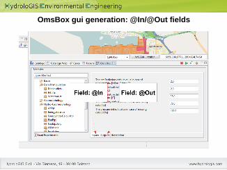
OmsBox gui generation: @In/@Out fields
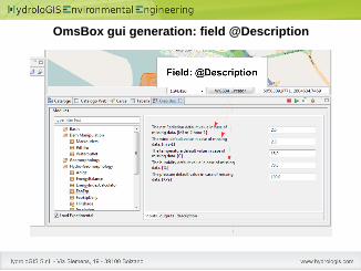
OmsBox gui generation: field @Description

OmsBox gui generation: field @Units and @Range
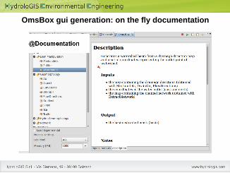
OmsBox gui generation: on the fly documentation

OmsBox gui generation: on the fly documentation

Geoinformatics FCE CTUPrague, Czech Republic, 19th of May 2011
Useful links:
• http://www.javaforge.com/project/oms
• http://www.jgrasstools.org
• http://udig.refractions.net
• http://www.geotools.org