LinkedGeoData: A Core for a Web of Spatial Open...
22
Semantic Web 0 (0) 1 1 IOS Press LinkedGeoData: A Core for a Web of Spatial Open Data Editor(s): Krzysztof Janowicz, University of California, Santa Barbara, USA Solicited review(s): Simon Scheider, University of Münster, Germany; Prateek Jain, Wright State University, USA; Dalia Varanka, U.S. Geological Survey, USA Open review(s): Boyan Brodaric, Geological Survey of Canada, Canada Claus Stadler a,* , Jens Lehmann a , Konrad Höffner a , Sören Auer a a Department of Computer Science, University of Leipzig Johannisgasse 26, 04103 Leipzig, Germany {cstadler, lehmann, auer}@informatik.uni-leipzig.de, [email protected] Abstract. The Semantic Web eases data and information integration tasks by providing an infrastructure based on RDF and ontologies. In this paper, we contribute to the development of a spatial Data Web by elaborating on how the collaboratively collected OpenStreetMap data can be interactively transformed and represented adhering to the RDF data model. This transfor- mation will simplify information integration and aggregation tasks that require comprehensive background knowledge related to spatial features such as ways, structures, and landscapes. We describe how this data is interlinked with other spatial data sets, how it can be made accessible for machines according to the Linked Data paradigm and for humans by means of several applications, including a faceted geo-browser. The spatial data, vocabularies, interlinks and some of the applications are openly available in the LinkedGeoData project. Keywords: Linked Data, Spatial Data, Open Data, Interlinking, RDF, RDB2RDF, OpenStreetMap, LinkedGeoData 1. Introduction The Semantic Web eases data integration tasks by providing an infrastructure based on RDF and ontolo- gies. In order to employ the Web as a medium for data and information integration, comprehensive datasets and vocabularies are required as they enable the dis- ambiguation and alignment of other data and informa- tion. With DBpedia [14], a large reference dataset pro- viding encyclopedic knowledge about a multitude of different domains is already available. A number of other datasets tackling domains such as entertainment, * This work was supported by a grant from the European Union’s 7th Framework Programme provided for the projects LOD2 (GA no. 257943) and LATC (GA no. 256975). bio-medicine or bibliographic data are available in the emerging Linked Data Web 1 . With the OpenStreetMap (OSM) 2 project, a rich source of spatial data is freely available. It is currently used primarily for rendering various map visualiza- tions, but has the potential to evolve into a crystalliza- tion point for spatial Web data integration. The goal of our LinkedGeoData (LGD) project is to lift OSM’s data into the Semantic Web infrastruc- ture. We believe that this will simplify real-life infor- mation integration and aggregation tasks that require comprehensive background knowledge related to spa- tial features. Such tasks might include, for example, to locally depict the offerings of the bakery shop next 1 See, for example, the listing at http://ckan.net/group/ lodcloud and an overview at http://lod-cloud.net. 2 http://openstreetmap.org 1570-0844/0-1900/$27.50 c 0 – IOS Press and the authors. All rights reserved
Transcript of LinkedGeoData: A Core for a Web of Spatial Open...
Semantic Web 0 (0) 1 1IOS Press
LinkedGeoData:A Core for a Web of Spatial Open DataEditor(s): Krzysztof Janowicz, University of California, Santa Barbara, USASolicited review(s): Simon Scheider, University of Münster, Germany; Prateek Jain, Wright State University, USA; Dalia Varanka, U.S.Geological Survey, USAOpen review(s): Boyan Brodaric, Geological Survey of Canada, Canada
Claus Stadler a,∗, Jens Lehmann a, Konrad Höffner a, Sören Auer aa Department of Computer Science, University of LeipzigJohannisgasse 26, 04103 Leipzig, Germany{cstadler, lehmann, auer}@informatik.uni-leipzig.de, [email protected]
Abstract. The Semantic Web eases data and information integration tasks by providing an infrastructure based on RDF andontologies. In this paper, we contribute to the development of a spatial Data Web by elaborating on how the collaborativelycollected OpenStreetMap data can be interactively transformed and represented adhering to the RDF data model. This transfor-mation will simplify information integration and aggregation tasks that require comprehensive background knowledge related tospatial features such as ways, structures, and landscapes. We describe how this data is interlinked with other spatial data sets, howit can be made accessible for machines according to the Linked Data paradigm and for humans by means of several applications,including a faceted geo-browser. The spatial data, vocabularies, interlinks and some of the applications are openly available inthe LinkedGeoData project.
Keywords: Linked Data, Spatial Data, Open Data, Interlinking, RDF, RDB2RDF, OpenStreetMap, LinkedGeoData
1. Introduction
The Semantic Web eases data integration tasks byproviding an infrastructure based on RDF and ontolo-gies. In order to employ the Web as a medium for dataand information integration, comprehensive datasetsand vocabularies are required as they enable the dis-ambiguation and alignment of other data and informa-tion. With DBpedia [14], a large reference dataset pro-viding encyclopedic knowledge about a multitude ofdifferent domains is already available. A number ofother datasets tackling domains such as entertainment,
*This work was supported by a grant from the European Union’s7th Framework Programme provided for the projects LOD2 (GA no.257943) and LATC (GA no. 256975).
bio-medicine or bibliographic data are available in theemerging Linked Data Web1.
With the OpenStreetMap (OSM)2 project, a richsource of spatial data is freely available. It is currentlyused primarily for rendering various map visualiza-tions, but has the potential to evolve into a crystalliza-tion point for spatial Web data integration.
The goal of our LinkedGeoData (LGD) project isto lift OSM’s data into the Semantic Web infrastruc-ture. We believe that this will simplify real-life infor-mation integration and aggregation tasks that requirecomprehensive background knowledge related to spa-tial features. Such tasks might include, for example,to locally depict the offerings of the bakery shop next
1See, for example, the listing at http://ckan.net/group/lodcloud and an overview at http://lod-cloud.net.
2http://openstreetmap.org
1570-0844/0-1900/$27.50 c© 0 – IOS Press and the authors. All rights reserved
2 Stadler et. al / LinkedGeoData
door, to map distributed branches of a company, or tointegrate information about historical sights along a bi-cycle track.
The majority of our data is obtained by convert-ing data from the popular OpenStreetMap commu-nity project to RDF and deriving a lightweight ontol-ogy from it. Furthermore, we perform interlinking withDBpedia, GeoNames, and other datasets, as well as theintegration of icons and multilingual class labels fromvarious sources. As a side effect, we are striving for theestablishment of an OWL vocabulary with the purposeof simplifying exchange and reuse of geographic data.
After our initial LGD release in 2009 [1], we in-vested substantial efforts in maintaining and improv-ing LinkedGeoData, which include improvements ofthe project infrastructure, the generated ontology, anddata quality in general. Our new contributions sincethen are:
– A flexible system for mapping OpenStreetMapdata to RDF: We now support nicer URIs (camelcase), typed literals, language tags, and a sim-plified mapping of the OSM data to classes andproperties. Together this accounts for an improveddata quality.
– Better support for ways: Ways are OpenStreetMapentities used for modeling things such as streetsbut also areas (see Section 2). The geometry of away (a line or a polygon) is now stored in a literalof the corresponding RDF resource, which makesit easy to e.g. display such a resource on a map.Furthermore, all nodes referenced by a way areavailable both via the Linked Data interface andthe SPARQL endpoints.
– An improved REST interface with integratedsearch functions.
– A new publicly accessible live SPARQL end-point that is being interactively updated with theminutely changesets that OpenStreetMap pub-lishes.
– A simple republication method of the correspond-ing RDF changesets so that LinkedGeoData dataconsumers can replicate our store.
– Direct interlinking with GeoNames and the UNFAO data (interlinks with DBpedia have been up-dated).
– An improved LinkedGeoData browser.– Implementation of the Vicibit application to facil-
itate the integration of LGD facet views in exter-nal web pages.
– Integration of appropriate icons and multilin-gual labels for LinkedGeoData ontology ele-ments from external sources.
The paper is structured as follows: after introducingthe OpenStreetMap project in Section 2, we outline theLinkedGeoData architecture in Section 3. Subsequentsections explain, how the OSM data is transformedinto the RDF data model (Section 4), how the data canbe accessed (Section 5), and how we interlinked it withother knowlegde bases (Section 6). The live synchro-nization is explained in Section 7. We present statis-tics about LinkedGeoData in Section 8. In Section 9,we showcase a faceted geo-data browser and editor aswell as some 3rd party applications being built aroundLinkedGeoData. We present related work in Section 10and conclude in Section 11 with an outlook to futurework.
2. OpenStreetMap
OpenStreetMap is a collaborative project to create afree editable map of the whole world. It was inspiredby Wikipedia and as such it provides well known wikifeatures such as an edit-tab and a full revision historyof the edits. However, rather than editing articles, usersedit geographic entities. The three fundamental onesare as follows:
– Nodes are the most primitive entities and repre-sent geographic points with a latitude and longi-tude relative to the WGS84 reference system.
– Ways are entities that have a list of at least twonode references associated with them. Dependingon whether the first reference equals the last one,a way is called closed or open, respectively.
– Relations relate points, ways and potentially otherrelations to each other, thereby forming complexobjects. Each entity participating in a relationplays a certain role in it. Multipolygons are mod-elled with relations.
Each of these entities has a numeric identifier (calledOSM ID), a set of generic attributes, and most im-portantly is described using a set of key-value pairs,known as tags.
An example of a relation is the administrativeboundary of Germany having the OSM identifier51477.3 It is comprised by more than 1000 ways,
3http://www.openstreetmap.org/browse/relation/51477 can be used to browse this relation.
Stadler et. al / LinkedGeoData 3
which represent certain segments of the German bor-der; the German border with Luxembourg e.g. iscomposed of approx. 40 way segments. The rela-tion currently has about 30 associated tag-value pairs,which, for example, contain the name of Germanyin different languages. One of those tag-value pairs(boundary=administrative) indicates that thisrelation represents an administrative boundary. Thisinformation is used by the OSM map renderer to de-cide how this relation should be rendered on the map.Further tags are used for timezone, currency, and ISOcountry. The relation has also a few metadata entries(such as the timestamp of the last edit and the last edi-tor) attached.
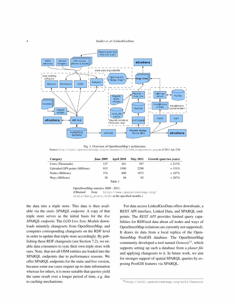
To manage those data structures, an infrastructureevolved encompassing multiple map editing tools, tilerenderers, and data sources, as shown in Figure 1.
The data is stored in a relational database (Post-greSQL backend). It can be accessed, queried andedited by using a REST API, which basically usesHTTP GET, PUT and DELETE requests with XMLpayload (similar to the example shown in Listing 4).The data is also published as complete dumps of thedatabase in such an XML format on a weekly basis. Itcurrently accounts for more than 16GB of Bzip2 com-pressed data. In minutely, hourly and daily intervalsthe project additionally publishes changesets, whichcan be used to synchronize a local deployment of thedata with the OSM database. The dumps as well as thechangesets can be processed with the Osmosis tool.
OpenStreetMap’s community has build different au-thoring interfaces. These include the online editor Pot-latch, which is implemented in Flash and accessibledirectly via the edit tab at the OSM map view, as wellas the desktop applications JOSM, Merkaartor andMapzen. The editors use complementary external ser-vices and data such as Yahoo! satellite imagery or WebMap Services (WMS). Additionally, users can uploadGPS traces which serve as raw material for modelingthe map. Two different rendering services are offeredfor the rendering of raster maps on different zoom lev-els. With Tiles@home, the performance-intense ren-dering tasks are dispatched to idle machines of com-munity members; thus achieving timeliness. The Map-nik renderer, in turn, operates on a central tile serverand re-renders tiles only in certain intervals.
Since the use of tags and values is not restricted, butgoverned by an agile community process, it is impor-tant to obtain an overview on emerging tags and tagvalues possibly specific to a certain region. Services
such as TagWatch4 periodically compute tag statisticsfor different areas. In order for the data to be ma-chine interpretable, as for instance for map rendering,contributors must follow certain editing standards andconventions5.
Currently, OSM is in the process of switching fromthe Creative Commons CC-BY-SA license to the OpenDatabase License6. The term Volunteered GeographicInformation (VGI) was coined [9] for the harnessing oftools to create, assemble, and disseminate geographicdata provided voluntarily by individuals – with OSMbeing a driving force behind VGI.
The growth of the OpenStreetMap data has beenenormous (cf. Table 1): Since the founding in July2004 until now, more than one billion nodes, about90 million ways and close to 1 million relations havebeen contributed by the users7. Some of the datawas imported form public domain datasources such asTIGER8 for US, AND Automotive Navigation Data9
for The Netherlands, and GeoBase data from the Cana-dian government10.
3. Architecture
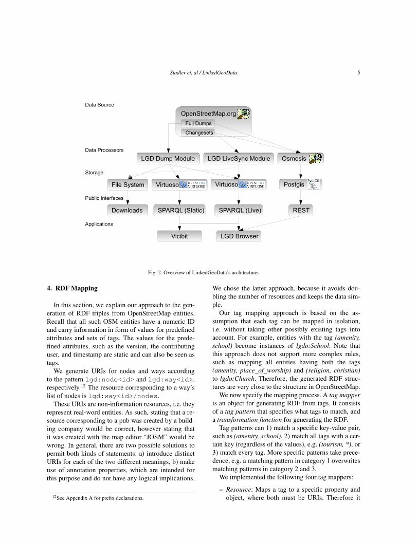
The goal of the LinkedGeoData the project is to con-tribute rich, open, and integrated geographical data tothe Semantic Web using OpenStreetMap as its base.This is analogous to the well known DBpedia project,which follows a similar approach based on Wikipedia.The necessary work for reaching this goal comprisesthe conversion of OSM data to RDF, the interlinkingwith other knowledge bases, the dissemination of theresulting data, and keeping the datasets up-to-date. Inthis section, we give an overview of the LinkedGeo-Data architecture, followed by explanations of the de-tails of the involved components in the next sections.
The architecture of LinkedGeoData is illustrated inFigure 2. It shows that the data from OpenStreetMapis processed on different routes: The LGD Dump Mod-ule converts an OSM planet file to RDF and loads
4http://tagwatch.stoecker.eu/5http://wiki.openstreetmap.org/wiki/Map_
Features6http://www.opendatacommons.org/licenses/
odbl/7http://www.openstreetmap.org/stats/data_
stats.html, retrieved 2011 May 2nd8http://www.census.gov/geo/www/tiger9http://www.and.com/10http://www.geobase.ca
4 Stadler et. al / LinkedGeoData
Fig. 1. Overview of OpenStreetMap’s architecture.Source:http://wiki.openstreetmap.org/w/images/1/15/OSM_Components.png as of 2011 Apr 27th
Category June 2009 April 2010 May 2011 Growth (past two years)Users (Thousands) 127 261 397 + 213%Uploaded GPS points (Millions) 915 1500 2298 + 151%Nodes (Millions) 374 600 1073 + 187%Ways (Millions) 30 48 92 + 207%
Table 1
OpenStreetMap statistics 2009 - 2011.(Obtained from http://www.openstreetmap.org/stats/data_stats.html at the specified months.)
the data into a triple store. This data is then avail-able via the static SPARQL endpoint. A copy of thattriple store serves as the initial basis for the liveSPARQL endpoint. The LGD Live Sync Module down-loads minutely changesets from OpenStreetMap, andcomputes corresponding changesets on the RDF levelin order to update that triple store accordingly. By pub-lishing these RDF changesets (see Section 7.2), we en-able data consumers to sync their own triple store withours. Note, that not all OSM entities are loaded into theSPARQL endpoints due to performance reasons. Weoffer SPARQL endpoints for the static and live version,because some use cases require up-to-date informationwhereas for others, it is more suitable that queries yieldthe same result over a longer period of time, e.g. dueto caching mechanisms.
For data access LinkedGeoData offers downloads, aREST API interface, Linked Data, and SPARQL end-points. The REST API provides limited query capa-bilities for RDFized data about all nodes and ways ofOpenStreetMap (relations are currently not supported).It draws its data from a local replica of the Open-StreetMap PostGIS database. The OpenStreetMapcommunity developed a tool named Osmosis11, whichsupports setting up such a database from a planet fileand applying changesets to it. In future work, we aimfor stronger support of spatial SPARQL queries by ex-posing PostGIS features via SPARQL.
11http://wiki.openstreetmap.org/wiki/Osmosis
Stadler et. al / LinkedGeoData 5
OpenStreetMap.org
LGD Dump Module Osmosis
Changesets
Full Dumps
VirtuosoVirtuoso Postgis
Storage
Data Processors
Public Interfaces
Data Source
SPARQL (Live)SPARQL (Static) REST
LGD LiveSync Module
Downloads
File System
Applications
Vicibit LGD Browser
Fig. 2. Overview of LinkedGeoData’s architecture.
4. RDF Mapping
In this section, we explain our approach to the gen-eration of RDF triples from OpenStreetMap entities.Recall that all such OSM entities have a numeric IDand carry information in form of values for predefinedattributes and sets of tags. The values for the prede-fined attributes, such as the version, the contributinguser, and timestamp are static and can also be seen astags.
We generate URIs for nodes and ways accordingto the pattern lgd:node<id> and lgd:way<id>,respectively.12 The resource corresponding to a way’slist of nodes is lgd:way<id>/nodes.
These URIs are non-information resources, i.e. theyrepresent real-word entities. As such, stating that a re-source corresponding to a pub was created by a build-ing company would be correct, however stating thatit was created with the map editor “JOSM” would bewrong. In general, there are two possible solutions topermit both kinds of statements: a) introduce distinctURIs for each of the two different meanings, b) makeuse of annotation properties, which are intended forthis purpose and do not have any logical implications.
12See Appendix A for prefix declarations.
We chose the latter approach, because it avoids dou-bling the number of resources and keeps the data sim-ple.
Our tag mapping approach is based on the as-sumption that each tag can be mapped in isolation,i.e. without taking other possibly existing tags intoaccount. For example, entities with the tag (amenity,school) become instances of lgdo:School. Note thatthis approach does not support more complex rules,such as mapping all entities having both the tags(amenity, place_of_worship) and (religion, christian)to lgdo:Church. Therefore, the generated RDF struc-tures are very close to the structure in OpenStreetMap.
We now specify the mapping process. A tag mapperis an object for generating RDF from tags. It consistsof a tag pattern that specifies what tags to match, anda transformation function for generating the RDF.
Tag patterns can 1) match a specific key-value pair,such as (amenity, school), 2) match all tags with a cer-tain key (regardless of the values), e.g. (tourism, *), or3) match every tag. More specific patterns take prece-dence, e.g. a matching pattern in category 1 overwritesmatching patterns in category 2 and 3.
We implemented the following four tag mappers:
– Resource: Maps a tag to a specific property andobject, where both must be URIs. Therefore it
6 Stadler et. al / LinkedGeoData
can be used for mapping to both object prop-erties and classes. In the latter case the prop-erty has to be set to rdf:type. Examples are(religion, christian) and (amenity, school) whichare mapped to lgdo:religion lgdo:christian andrdf:type lgdo:School, respectively.
– Text: Treats a tag’s value as a plain literal. For ex-ample (note, nice view).
– Datatype: Interpret a value e.g. (seats, 4) with re-gard to a specific datatype.
– Language: A mapper for tags whose key containsa language, such as name:en.
All of these mappings are implemented as Javaclasses, whose instances are configured with an XMLsnippet. Listing 1 shows an example of a configura-tion of a resource tag mapper that is interpreted as fol-lows: The ’simple’ in the name reflects our limitationthat tags are being mapped in isolation. The mappingrule is applied to every entity that has a tag match-ing the pattern (religion,*). The element objectAsPre-fix controls whether a tag’s value should be appendedto the value given as the object. So in this case, a tag,such as (religion, hindi), is mapped to the predicatelgdo:religion and object lgdo:hindi. The el-ement describesOSMEntity specifies whether the re-sulting RDF describes a real world entity’s representa-tion on OpenStreetMap or the entity itself. Therefore,it determines whether a mapping’s property should be-come an instance of owl:AnnotationProperty.
The text- and datatype tag mappers are both similarto the resource tag mapper, except that they map tagvalues to objects that are plain or typed literals, respec-tively. Therefore the language and datatype of thesemappers can be set to a constant in their configuration.
The language tag mapper is used for mapping tagvalues to plain literals with language tags inferredfrom the tags’ keys. For instance (name:en, Vienna)would become (rdfs:label, “Vienna”@en). The keyof its tag-pattern must be a regular expression con-taining a group for matching the language, such asname:([^:]+). Every match for this group is thencross checked against a list of known languages. Thisavoids for example matching ’alt’ as a language fromthe key name:alt for alternative names.
Listing 1: Example of a mapping declaration.<SimpleResourceTagMapper>
<property>http://linkedgeodata.org/ontology/religion
</property><tagPattern>
<key>religion</key></tagPattern><describesOSMEntity>false</describesOSMEntity><objectAsPrefix>true</objectAsPrefix><object>http://linkedgeodata.org/ontology/
</object></SimpleResourceTagMapper>
This approach makes it possible to add new map-pings that require more complex processing easy. Forexample, a future tag mapper could extract the valuesof opening_hours tags (used 60K times on nodes) andgenerate RDF in the Good Relations13 vocabulary.
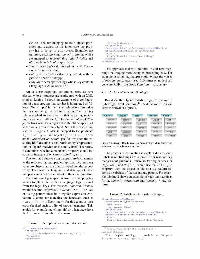
4.1. The LinkedGeoData Ontology
Based on the OpenStreetMap tags, we derived alightweight OWL ontology14. A depiction of an ex-cerpt in shown in Figure 3.
Bench
Brewery
Cafe
Bakery
Pub Village
Town
City
Country
Hamlet
Golf
Hockey
Judo
Rugby
Paintball
Hostel
Hotel
Motel
Chalet
Resort
Amenity SportPlace TourismLeisure
Pitch
Stadium
Track
Beach
DogPark
Fig. 3. An excerpt of the LinkedGeoData ontology. More classes andsubclasses exist in the actual version.
The process of its creation is explained as follows:Subclass relationships are inferred from resource tagmapper configurations: If there are two tag patterns for(tag1, tag2) and (tag1, *), which use the rdf:typeproperty, then the object of the first tag pattern be-comes a subclass of the second tag pattern. For exam-ple, Listing 2 shows an example of such tag mappingsfor the (amenity, restaurant) and (amenity, *) tag pat-terns.
Listing 2: Subclass relationship example.<SimpleResourceTagMapper><property>rdf:type</property><tagPattern><key>amenity</key>
</tagPattern><describesOSMEntity>false</describesOSMEntity><objectAsPrefix>false</objectAsPrefix><object>http://linkedgeodata.org/ontology/Amenity
13http://www.heppnetz.de/projects/goodrelations/
14The complete ontology is available at http://linkedgeodata.org/ontology/
Stadler et. al / LinkedGeoData 7
</object></SimpleResourceTagMapper><SimpleResourceTagMapper>
<property>rdf:type</property><tagPattern>
<key>amenity</key><value>restaurant</value>
</tagPattern><describesOSMEntity>false</describesOSMEntity><objectAsPrefix>false</objectAsPrefix><object>
http://linkedgeodata.org/ontology/Restaurant</object>
</SimpleResourceTagMapper>
In order to determine datatype properties, we scannedall OSM tags for those that had keys for which the ma-jority of values could be parsed as boolean, integer, orfloat datatype values. In order to deal with dirtiness intag usage, we applied the following two criteria on therelative and absolute error rate:
– At least 99% of a key’s values must succeed toparse.
– The absolute number of errors must not exceed5000.
The most specific datatype meeting these criteria thenbecame the range of the key’s corresponding property.If a datatype was determined, all invalid values wereomitted in the RDF output.
Object properties were identified as follows: Intu-itively, tags that might be suitable for being mapped toobject properties meet the condition, that a low numberof distinct values covers most its uses. However, thisheuristic only serves as an indicator for tag candidates,as the final choice may be subjective. For instance,only 7 distinct values for the key note:ja are used inmore than 99% of almost 3.5mio tags. However, sincethe tag corresponds to a note, we considered a datatypeproperty to be the right choice. An example for an ob-ject property is lgdo:religion, which links to resourcesin the lgdo namespace, such as christian, muslim, andbuddhist. Another example is lgdo:wheelchair, whichspecifies the extent of wheelchair accessibility, usingresources mainly corresponding to the values yes, no,limited, and unknown. Using those heuristics, we couldgenerate seed mappings for OpenStreetMap, whichwere then manually reviewed and refined.
4.2. Multilingual labels and icons
The OpenStreetMap community conducts variousinternationalization efforts, such as for their website,their map editing tools, and their search engine. Someof these efforts are coordinated on TranslateWiki,
which describes itself as “a localisation platform fortranslation communities, language communities, andfree and open source projects.”15 Essentially, this wikienables contributors to assign texts in multiple lan-guages to keys. The group OpenStreetMap - Websitedefines 1441 keys, and has a 100% translation cov-erage for 13 languages and 12 more languages witha coverage of more than 90%16. They keys with theprefix geocoder.search_osm_nominatim.prefix corre-spond to human readable representations of individualtags, and as such form a rich, multilingual, and highquality source of labels for classes, properties, and in-stances, which we integrated into the LinkedGeoDataontology.
These labels could serve as a basis for answeringqueries posed in different languages: For a query suchas “Bakeries in Munich” and its German equivalent“Bäckereien in München”, the search words could bemapped to corresponding classes and instances fromthe LinkedGeoData knowledge base. A system alreadycapable of processing such types of queries is de-scribed in [20].
As for icons, there exists a CC-0 licensed col-lection of 307 SVG map icons (of which 47 iconsare alternative versions) from SJJB Management.17
Currently the LinkedGeoData ontology associates 90of them with classes, using the annotation prop-erty lgdo:schemaIcon. The icons themselves are re-published on our server. They simplify the creationof visually appealing LGD based applications andmashups.
5. Data Access
As briefly mentioned in Section 3, we provide sev-eral ways to access LinkedGeoData:
– dataset downloads (HTML download table18 andactual files19), including live sync changesets rel-ative to the latest release20 (explained in Sec-tion 7)
15http://translatewiki.net16http://translatewiki.net/wiki/Translating:
OpenStreetMap/stats/trunk retrieved 5th May 2011.17http://www.sjjb.co.uk/mapicons/ retrieved 6th
April 201118http://linkedgeodata.org/Datasets19http://downloads.linkedgeodata.org20http://downloads.linkedgeodata.org/
releases/latest/changesets/
8 Stadler et. al / LinkedGeoData
– a static SPARQL endpoint21
– a live SPARQL endpoint22
– Linked Data via 303 content negotation (RD-F/XML, Turtle, N-Triples, HTML formats sup-ported)
– a REST API
We first show an example data excerpt and then ex-plain the REST API.
5.1. Data example
In Listing 3, we give a brief example on what thedata in LinkedGeoData looks like. The whole type hi-erarchy is already inferred, as it is being done in DB-pedia, i.e. rdf:type relations to all super classesare asserted. The lgdo:directType property was addedon request in order for applications to easily deter-mine the most specific type(s) of instances. For ev-ery way, there exists a triple that contains the posi-tions of all nodes. For open and closed ways the predi-cates are georss:linestring and georss:polygon, respec-tively. Note that this interpretation is not always cor-rect, as in the general case closed ways have to be in-terpreted in the context of the ways’ tags in order todetermine whether the enclosed area counts to the wayor not. All nodes belonging to a way are kept in anRDF sequence. In the SPARQL endpoints, geograph-ical coordinates are represented as point geometriesthat are typed with virtrdf:Geometry. OpenLink’s Vir-tuoso23 enterprise edition database system automati-cally indexes such points in an R-tree.
Listing 3: Example dataset in Turtle syntax.
lgd:way4009992a lgdo:Tennis, lgdo:Sport, lgdo:Way;lgdo:directType lgdo:Tennis;lgdo:contributor lgd:user2274;lgdo:hasNodes <http://.../way4009992/nodes>;georss:polygon "52.1523857 -1.026259
52.1522675 -1.0264068 ..." .<http://.../way4009992/nodes>
a rdf:Seq;rdf:_1 lgd:node21179607;rdf:_2 lgd:node21179608;... .
lgd:node21179607 geo:geometry"POINT(-1.02626 52.1524)"^^virtrdf:Geometry
Fig. 4. Data Sources of the REST API.
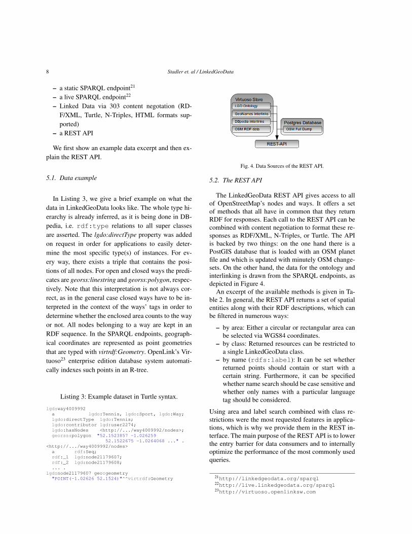
5.2. The REST API
The LinkedGeoData REST API gives access to allof OpenStreetMap’s nodes and ways. It offers a setof methods that all have in common that they returnRDF for responses. Each call to the REST API can becombined with content negotiation to format these re-sponses as RDF/XML, N-Triples, or Turtle. The APIis backed by two things: on the one hand there is aPostGIS database that is loaded with an OSM planetfile and which is updated with minutely OSM change-sets. On the other hand, the data for the ontology andinterlinking is drawn from the SPARQL endpoints, asdepicted in Figure 4.
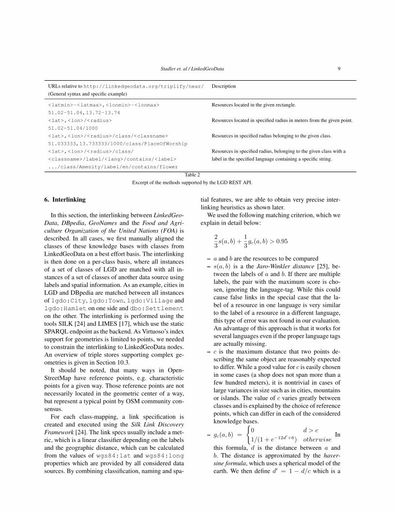
An excerpt of the available methods is given in Ta-ble 2. In general, the REST API returns a set of spatialentities along with their RDF descriptions, which canbe filtered in numerous ways:
– by area: Either a circular or rectangular area canbe selected via WGS84 coordinates.
– by class: Returned resources can be restricted toa single LinkedGeoData class.
– by name (rdfs:label): It can be set whetherreturned points should contain or start with acertain string. Furthermore, it can be specifiedwhether name search should be case sensitive andwhether only names with a particular languagetag should be considered.
Using area and label search combined with class re-strictions were the most requested features in applica-tions, which is why we provide them in the REST in-terface. The main purpose of the REST API is to lowerthe entry barrier for data consumers and to internallyoptimize the performance of the most commonly usedqueries.
21http://linkedgeodata.org/sparql22http://live.linkedgeodata.org/sparql23http://virtuoso.openlinksw.com
Stadler et. al / LinkedGeoData 9
URLs relative to http://linkedgeodata.org/triplify/near/ Description(General syntax and specific example)
<latmin>-<latmax>,<lonmin>-<lonmax> Resources located in the given rectangle.51.02-51.04,13.72-13.74
<lat>,<lon>/<radius> Resources located in specified radius in meters from the given point.51.02-51.04/1000
<lat>,<lon>/<radius>/class/<classname> Resources in specified radius belonging to the given class.51.033333,13.733333/1000/class/PlaceOfWorship
<lat>,<lon>/<radius>/class/ Resources in specified radius, belonging to the given class with a<classname>/label/<lang>/contains/<label> label in the specified language containing a specific string..../class/Amenity/label/en/contains/flower
Table 2Excerpt of the methods supported by the LGD REST API.
6. Interlinking
In this section, the interlinking between LinkedGeo-Data, DBpedia, GeoNames and the Food and Agri-culture Organization of the United Nations (FOA) isdescribed. In all cases, we first manually aligned theclasses of these knowledge bases with classes fromLinkedGeoData on a best effort basis. The interlinkingis then done on a per-class basis, where all instancesof a set of classes of LGD are matched with all in-stances of a set of classes of another data source usinglabels and spatial information. As an example, cities inLGD and DBpedia are matched between all instancesof lgdo:City, lgdo:Town, lgdo:Village andlgdo:Hamlet on one side and dbo:Settlementon the other. The interlinking is performed using thetools SILK [24] and LIMES [17], which use the staticSPARQL endpoint as the backend. As Virtuoso’s indexsupport for geometries is limited to points, we neededto constrain the interlinking to LinkedGeoData nodes.An overview of triple stores supporting complex ge-ometries is given in Section 10.3.
It should be noted, that many ways in Open-StreetMap have reference points, e.g. characteristicpoints for a given way. Those reference points are notnecessarily located in the geometric center of a way,but represent a typical point by OSM community con-sensus.
For each class-mapping, a link specification iscreated and executed using the Silk Link DiscoveryFramework [24]. The link specs usually include a met-ric, which is a linear classifier depending on the labelsand the geographic distance, which can be calculatedfrom the values of wgs84:lat and wgs84:longproperties which are provided by all considered datasources. By combining classification, naming and spa-
tial features, we are able to obtain very precise inter-linking heuristics as shown later.
We used the following matching criterion, which weexplain in detail below:
2
3s(a, b) +
1
3gc(a, b) > 0.95
– a and b are the resources to be compared– s(a, b) is a the Jaro-Winkler distance [25], be-
tween the labels of a and b. If there are multiplelabels, the pair with the maximum score is cho-sen, ignoring the language-tag. While this couldcause false links in the special case that the la-bel of a resource in one language is very similarto the label of a resource in a different language,this type of error was not found in our evaluation.An advantage of this approach is that it works forseveral languages even if the proper language tagsare actually missing.
– c is the maximum distance that two points de-scribing the same object are reasonably expectedto differ. While a good value for c is easily chosenin some cases (a shop does not span more than afew hundred meters), it is nontrivial in cases oflarge variances in size such as in cities, mountainsor islands. The value of c varies greatly betweenclasses and is explained by the choice of referencepoints, which can differ in each of the consideredknowledge bases.
– gc(a, b) =
{0 d > c
1/(1 + e−12d′+6) otherwise
In
this formula, d is the distance between a andb. The distance is approximated by the haver-sine formula, which uses a spherical model of theearth. We then define d′ = 1 − d/c which is a
10 Stadler et. al / LinkedGeoData
linear function with a value of zero at distanced = c and one for d = 0. In order to not punisha slight discrepancy between two points as muchas a linear function would, d′ is not used directly.Instead, we employ a scaled logistic curve. Theremaining parameters are adjusted such that twoobjects at distance c with exactly the same labelsalmost exactly matches the threshold of 0.95 inthe formula above, which is the intended meaningof the parameter c.
6.1. Interlinking with DBpedia
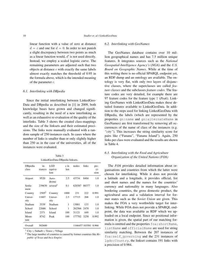
Since the initial interlinking between LinkedGeo-Data and DBpedia as described in [1] in 2009, bothknowledge bases have grown and changed signifi-cantly, resulting in the need of a new interlinking aswell as an exhaustive re-evaluation of the quality of theinterlinks. Table 3 shows the created class-mappingsand the size of the linksets and their estimated preci-sions. The links were manually evaluated with a ran-dom sample of 250 instances each. In cases where thenumber of links is smaller than or only slightly higherthan 250 as in the case of the universities, all of theinstances were evaluated.
Table 3LinkedGeoData-DBpedia linksets.
DBpediaclass
in-stances
LGDequiva-lent
c inkm
nodes links pre-ci-
sion
Airport 9520 Aero-drome
2.5 43734 8404 1.0
Settle-ment
239630 several1 0.1 620387 88377 1.0
Country 25052 Country 1000 231 222 0.991Univer-sity
11607 Univer-sity
2.5 17715 268 1.0
Stadium 5539 Stadium 1 13001 133 1.0School 22686 School 1 262566 2470 1.0Island 2371 Island 100 31121 449 1.0Moun-tain
8742 Peak 100 177702 3258 0.992
Overall 302600 1166457 103581 0.966
1 City ∪ Suburb ∪ Town ∪ Village2 The large number of countries is caused by former countries like Re-
public of Texas and Inca Empire.
6.2. Interlinking with GeoNames
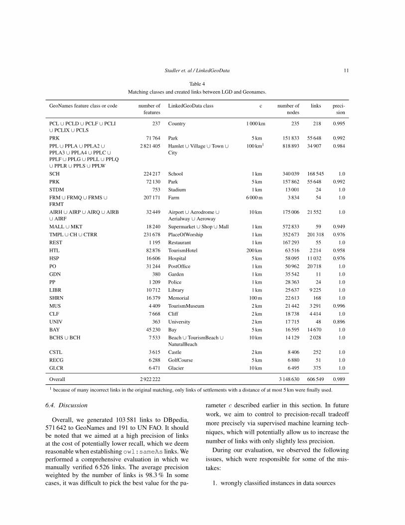
The GeoNames database contains over 10 mil-lion geographical names and has 7.5 million uniquefeatures. It integrates sources such as the NationalGeospatial-Intelligence Agency’s (NGA) and the U.S.Board on Geographic Names. While at the time ofthis writing there is no official SPARQL endpoint yet,an RDF-dump and an ontology are available. The on-tology is very flat, with only two layers of disjunc-tive classes, where the superclasses are called fea-ture classes and the subclasses feature codes. The fea-ture codes are very detailed, for example there are97 feature codes for the feature type T (Peak). Link-ing GeoNames with LinkedGeoData makes these de-tailed features available to LinkedGeoData. In addi-tion to the steps used for linking LinkedGeoData withDBpedia, the labels (which are represented by theproperties gn:name and gn:alternateName inGeoNames) are first transformed by removing all oc-currences of the name of class of the instances (e.g.“city”). This increases the string similarity score forpairs like (“Fananu”, “Fananu Island”). Again, 250links per class were evaluated and the results are shownin Table 4.
6.3. Interlinking with the Food and AgricultureOrganization of the United Nations (FOA)
The FOA provides detailed information about or-ganisations and countries from which the latter werechosen for interlinking. While it does not providea latitude and a longitude, it provides official, listand short names and the names for the countries’currency and nationality in many languages. Alsobordering countries, the gross domestic product, theagricultural area and a validation interval for for-mer states such as the Soviet Union are given. Thismakes the FOA a very worthwhile target for inter-linking. While FOA does not provide a SPARQL end-point, the data was available as RDF which we up-loaded on a local endpoint. Since no positional infor-mation is given, the spatial part of our matching for-mula is omitted and the properties foa:shortName,listName and officialName are used for stringsimilarity matching. Between the 207 instances offoa:self_governing and the 231 instances oflgdo:Country, the linkset contains 191 links witha precision of 0.984.
Stadler et. al / LinkedGeoData 11
Table 4Matching classes and created links between LGD and Geonames.
GeoNames feature class or code number offeatures
LinkedGeoData class c number ofnodes
links preci-sion
PCL ∪ PCLD ∪ PCLF ∪ PCLI∪ PCLIX ∪ PCLS
237 Country 1 000 km 235 218 0.995
PRK 71 764 Park 5 km 151 833 55 648 0.992PPL ∪ PPLA ∪ PPLA2 ∪PPLA3 ∪ PPLA4 ∪ PPLC ∪PPLF ∪ PPLG ∪ PPLL ∪ PPLQ∪ PPLR ∪ PPLS ∪ PPLW
2 821 405 Hamlet ∪ Village ∪ Town ∪City
100 km1 818 893 34 907 0.984
SCH 224 217 School 1 km 340 039 168 545 1.0PRK 72 130 Park 5 km 157 862 55 648 0.992STDM 753 Stadium 1 km 13 001 24 1.0FRM ∪ FRMQ ∪ FRMS ∪FRMT
207 171 Farm 6 000 m 3 834 54 1.0
AIRH ∪ AIRP ∪ AIRQ ∪ AIRB∪ AIRF
32 449 Airport ∪ Aerodrome ∪Aerialway ∪ Aeroway
10 km 175 006 21 552 1.0
MALL ∪MKT 18 240 Supermarket ∪ Shop ∪Mall 1 km 572 833 59 0.949TMPL ∪ CH ∪ CTRR 231 678 PlaceOfWorship 1 km 352 673 201 318 0.976REST 1 195 Restaurant 1 km 167 293 55 1.0HTL 82 876 TourismHotel 200 km 63 516 2 214 0.958HSP 16 606 Hospital 5 km 58 095 11 032 0.976PO 31 244 PostOffice 1 km 50 962 20 718 1.0GDN 380 Garden 1 km 35 542 11 1.0PP 1 209 Police 1 km 28 363 24 1.0LIBR 10 712 Library 1 km 25 637 9 225 1.0SHRN 16 379 Memorial 100 m 22 613 168 1.0MUS 4 409 TourismMuseum 2 km 21 442 3 291 0.996CLF 7 668 Cliff 2 km 18 738 4 414 1.0UNIV 363 University 2 km 17 715 48 0.896BAY 45 230 Bay 5 km 16 595 14 670 1.0BCHS ∪ BCH 7 533 Beach ∪ TourismBeach ∪
NaturalBeach10 km 14 129 2 028 1.0
CSTL 3 615 Castle 2 km 8 406 252 1.0RECG 6 288 GolfCourse 5 km 6 880 51 1.0GLCR 6 471 Glacier 10 km 6 495 375 1.0
Overall 2 922 222 3 148 630 606 549 0.989
1 because of many incorrect links in the original matching, only links of settlements with a distance of at most 5 km were finally used.
6.4. Discussion
Overall, we generated 103 581 links to DBpedia,571 642 to GeoNames and 191 to UN FAO. It shouldbe noted that we aimed at a high precision of linksat the cost of potentially lower recall, which we deemreasonable when establishing owl:sameAs links. Weperformed a comprehensive evaluation in which wemanually verified 6 526 links. The average precisionweighted by the number of links is 98.3 % In somecases, it was difficult to pick the best value for the pa-
rameter c described earlier in this section. In futurework, we aim to control to precision-recall tradeoffmore precisely via supervised machine learning tech-niques, which will potentially allow us to increase thenumber of links with only slightly less precision.
During our evaluation, we observed the followingissues, which were responsible for some of the mis-takes:
1. wrongly classified instances in data sources
12 Stadler et. al / LinkedGeoData
2. part vs. whole relations (‘West Anvil Point‘,‘AnvilPoint‘),
3. part vs. another part relations (‘West AnvilPoint‘,‘East Anvil Point‘), (“Red Wall Number1”, “Red Wall Number 2”)
4. subtle spelling differences (‘Bären-Klippe‘, ‘Beeren-klippe‘)
The first problem is a data quality issue and canonly partially be solved on our side by helping to im-prove the involved knowledge bases. The other issuescould be improved by a higher threshold, in particu-lar for string similarity. However, we found out thatthis had a very negative effect on recall. The problemcould be remedied by applying techniques like the Sta-ble Marriage Problem [16] to interlinking, which re-quires to incorporate support for this in the underly-ing interlinking tools and is subject to future work. Afurther problem, which we encountered in the match-ing problem was that despite several improvements inSILK, e.g. the introduction of blocking, the matchingsstill took several days to compute. Initial experimentswith LIMES gave comparable results in significantlyless time. We expect, that with such a new technology,will be able to run more extensive tests with differentparameter settings.
7. Live Synchronization
OpenStreetMap data is constantly being updated byits contributors. For instance, hundreds of shops areadded, removed or updated every day. Static snapshotsof this data cannot reflect such recent changes, whichmakes them unsuitable for use cases where users needup-to-date information. As a solution to this problem,we implemented a live-synchronization module, whichconverts the minutely changesets published by Open-StreetMap to RDF and updates a triple store accord-ingly. Additionally, we publish our changesets in anintuitive way that enables users of the LinkedGeoDataservice to synchronize their own RDF store with it.
An example of an application of LinkedGeoDatalive is the service MovieGoer24, which scrapes web-sites about cinemas in Munich and Innsbruck for theirprogram and stores the result as RDF. This data wasthen interlinked with LinkedGeoData, as the SPARQLendpoints provide a simple means of retrieving the ad-dresses and names for these cinemas. The locations
24http://lokino.sti2.at/
that were found out to be missing during the interlink-ing were added to OpenStreetMap, which made themalso available at the live LinkedGeoData endpoint. Asa result, a benefit for all involved services was created.
In the remainder of this section we first briefly de-scribe general requirements we pose on the update pro-cedure. Afterwards, we explain the changeset formatsof OpenStreetMaps and LinkedGeoData. Finally, wediscuss concrete cases that must be considered by ourlive-sync module and give a sketch of the algorithm.
7.1. General requirements
Our major design goals for the live sync procedurewere high performance and cleanliness: On the onehand, the update procedure must be capable of pro-cessing minutely changesets from OpenStreetMap inmuch less than a minute in order to catch up any lag toOpenStreetMap. On the other hand, the updates shouldnot leave our store in a dirty state - i.e. upon a modifi-cation or deletion of an OSM entity all RDF statementsabout the corresponding resources must reflect the en-tity’s most recent state, and no left-over statements ofa previous state must remain. Meeting both demandsresults in a non trivial procedure.
7.2. Changeset formats
We first explain the format of changesets providedby OpenStreetMap, and the format of our publishedRDF changesets. This eases the understanding of therequirements and details of the live sync procedure thatare explained in the sequel.
OpenStreetMap publishes changesets as sequen-tially numbered files in the XML-based OSM-Change(OSC) format. For instance, changeset #786001 ispublished at <base-path>/000/786/001.osc.gz.
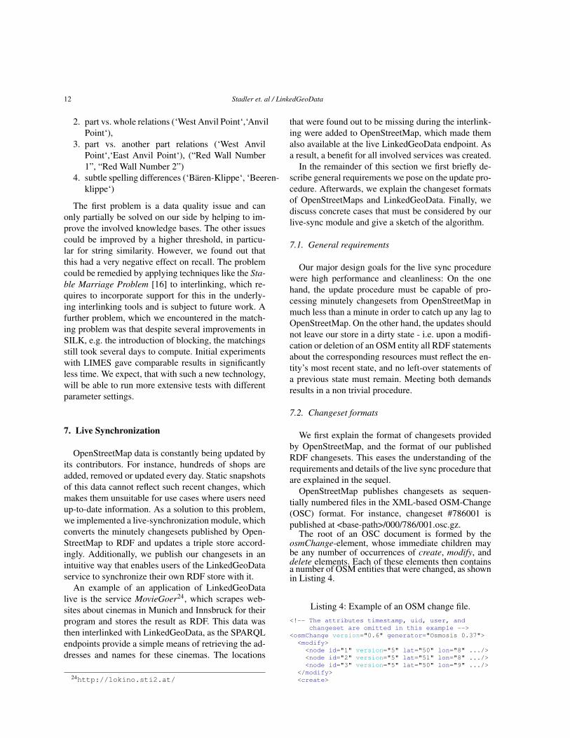
The root of an OSC document is formed by theosmChange-element, whose immediate children maybe any number of occurrences of create, modify, anddelete elements. Each of these elements then containsa number of OSM entities that were changed, as shownin Listing 4.
Listing 4: Example of an OSM change file.<!-- The attributes timestamp, uid, user, and
changeset are omitted in this example --><osmChange version="0.6" generator="Osmosis 0.37"><modify><node id="1" version="5" lat="50" lon="8" .../><node id="2" version="5" lat="51" lon="8" .../><node id="3" version="5" lat="50" lon="9" .../>
</modify><create>
Stadler et. al / LinkedGeoData 13
<way id="1" version="5" ...><nd ref="1"/><nd ref="2"/><nd ref="3"/><tag k="amenity" v="school"/><tag k="name:en" v="Mountain School"/>
</way></create><delete>
<node id="4" version="5" lat="50" lon="9" .../><tag k="created_by" v="Merkaartor 0.12"/>
</node></delete>
</osmChange>
The children of the create, modify and delete elementsare elements describing the affected OSM entities.These descriptions are interpreted in context of theirparent element as follows:
– Create: The state of the newly created entity.– Modify: The new state of the entity after its mod-
ification.– Delete: The state of the entity prior to its deletion.
There are two things worth noting: Firstly, changes arenot given on a per-tag, but on a per-entity basis and,secondly, the prior state to a modification is not givenin the OSC file.
Whenever the LGD live sync module processes anOSC file with a sequence number s, it publishes two N-Triples files containing the added and removed triples,namely s.added.nt.gz and s.removed.nt.gz.As a result, verification whether our changesets arecorrect can be done by examining the corresponding.osc file.
Since the RDF-based live sync operates on a per-statement basis, but changes are given on a per-entitybasis, the implication is, that during the syncronizationthe states of the entities need to be constantly queried.
7.3. Observations
In this part, we present the key aspects that needto be considered for a synchronization procedure thatmeets our requirements. We classify them according towhether they are general, or pertain to the changes ofnodes or ways.
General aspects
– Filtering: A vast amount of data is changed onOpenStreetMap every minute. Our experiencewith DBpedia [23] was that processing largeamounts of changes in RDF can cause severe per-formance issues with triple stores. In order to beperformance-wise on the safe side we decidedfrom the beginning to put filters in place. This en-
ables us to trade the completeness of the cover-age of the data for performance by adjusting theamount of changes that will be processed.
– Relevance: Any update should leave the storeonly with relevant data. Relevance in determinedin regard to a filter configuration consisting ofblack- and whitelisted tags (See 7.5). The filter-ing prevents the store from growing too large asupdates are being applied, and also prevents usersfrom receiving “dirty” answers to queries, such aswayNodes that are no longer connected to a way.
– Modifications: In the event of modifications, wedo not get an entities state prior to the change.Therefore, we need to query our store for eachmodified entity in order to compute the changeset.
Node-based aspects
– Repositioning of nodes: When a node positionis changed, the polygons/linestring property ofall referencing ways needs to be updated accord-ingly.
– Deletions and Modifications: Whenever a node isdeleted or modified and fails the relevance test itwill be removed - unless it is referenced by a rel-evant way.
Way-based aspects
– Whenever a way is created or modified, it maycontain references to nodes that are not in thechangeset (as the points themselves were notchanged). This makes it necessary to keep track ofall the nodes, as each of them may at some pointin time become connected to a way.
– LineStrings and Polygons: For each way the cor-responding linestring or polygon must be assem-bled.
– For every relevant way, all its referenced nodesalso need to be loaded.
– Irrelevant nodes that are referenced by relevantways should not carry any information exceptfor their position. Such nodes should not evenbe explicit instances of lgdo:Node in order toavoid many non-interesting triples which wouldincrease the dataset size and reduce performance.
– Whenever a way is modified, it may be no longerrelevant, and therefore needs to be removed.Whenever a way is removed, all nodes which arenot relevant by themselves also need to be re-moved.
14 Stadler et. al / LinkedGeoData
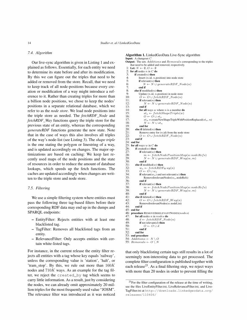
7.4. Algorithm
Our live-sync algorithm is given in Listing 1 and ex-plained as follows. Essentially, for each entity we needto determine its state before and after its modification.By this we can figure out the triples that need to beadded or removed from the store. Recall, that we needto keep track of all node-positions because every cre-ation or modification of a way might introduce a ref-erence to it. Rather than creating triples for more thana billion node positions, we chose to keep the nodes’positions in a separate relational database, which werefer to as the node store. We load node positions intothe triple store as needed. The fetchRDF_Node andfetchRDF_Way functions query the triple store for theprevious state of an entity, whereas the correspondinggenerateRDF functions generate the new state. Notethat in the case of ways this also involves all triplesof the way’s node-list (see Listing 3). The shape tripleis the one stating the polygon or linestring of a way,and is updated accordingly on changes. The major op-timizations are based on caching: We keep last re-cently used maps of the node positions and the stateof resources in order to reduce the amount of databaselookups, which speeds up the fetch functions. Thecaches are updated accordingly when changes are writ-ten to the triple store and node store.
7.5. Filtering
We use a simple filtering system where entities mustpass the following three tag-based filters before theircorresponding RDF data may end up in the dumps andSPARQL endpoints:
– EntityFilter: Rejects entities with at least oneblacklisted tag.
– TagFilter: Removes all blacklisted tags from anentity.
– RelevanceFilter: Only accepts entities with cer-tain white-listed tags.
For instance, in the current release the entity filter re-jects all entities with a tag whose key equals ’railway’,unless the corresponding value is ’station’, ’halt’, or’tram_stop’. By this, we rule out more than 160Knodes and 710K ways. As an example for the tag fil-ter, we reject the created_by tag which seems tocarry little information. As a result, just by consideringthe nodes, we can already omit approximately 20 mil-lion triples for the most frequently used value “JOSM”.The relevance filter was introduced as it was noticed
Algorithm 1. LinkedGeoData Live-Sync algorithmInput: A changeset COutput: The sets Additions and Removals corresponding to the triples
that need to be added and removed, respectively.1: Let: N ← ∅, O ← ∅2: for all nodes n in C do3: if created(n) then4: Insert (n.id, n.position) into node store5: if relevant(n) then6: N ← N ∪ generateRDF _Node(n)7: end if8: else if modified(n) then9: Update (n.id, n.position) in node store
10: O ← O ∪ fetchRDF _Node(n)11: if relevant(n) then12: N ← N ∪ generateRDF _Node(n)13: end if14: for all ways w where n is a member do15: sto ← fetchShapeTriple(w)16: O ← O ∪ sto17: stn = createNewShapeTripleWithPositionReplaced(sto, n)18: N ← N ∪ stn19: end for20: else if deleted(n) then21: Remove entry for (n.id) from the node store22: O ← O ∪ fetchRDF _Node(n)23: end if24: end for25: for all ways w in C do26: if created(w) then27: if relevant(w) then28: m← fetchNodePositionMap(w.nodeRefs)29: N ← N ∪ generateRDF _Way(w,m)30: end if31: else if modified(w) then32: wo ← fetchRDFW ay(n)33: O ← O ∪ wo
34: if relevant(wo) and not relevant(w) then35: RemoveIrrelevantNodes(wo.nodeRefs)36: end if37: if relevant(w) then38: m← fetchNodePositionMap(w.nodeRefs)39: N ← N ∪ generateRDF _Way(w,m)40: end if41: else if deleted(w) then42: O ← O ∪ fetchRDF _Way(n)43: RemoveIrrelevantNodes(w.nodeList)44: end if45: end for46: procedure REMOVEIRRELEVANTNODES(nodes) .47: for all nodes n in nodes do48: d← fetchRDF _Node(n)49: if not relevant(d) then50: O ← O ∪ d51: end if52: end for53: end procedure54: Additions← N \O55: Removals← O \N
that only blacklisting certain tags still results in a lot ofseemingly non-interesting data to get processed. Thecomplete filter configuration is published together witheach release25. As a final filtering step, we reject wayswith more than 20 nodes in order to prevent filling the
25For the filter configuration of the release at the time of writing,see the files LiveEntityFilter.txt, LiveRelevanceFilter.txt, and Live-TagFilter.txt at http://downloads.linkedgeodata.org/releases/110406/
Stadler et. al / LinkedGeoData 15
store mainly with way-node relations rather than in-formation based on tags, as each way-node relation re-sults in two triples: one for relating the way to its node,and one for each node position. Therefore, a single waywith a relevant tag and 20 nodes already results in morethan 40 triples.
8. Statistics
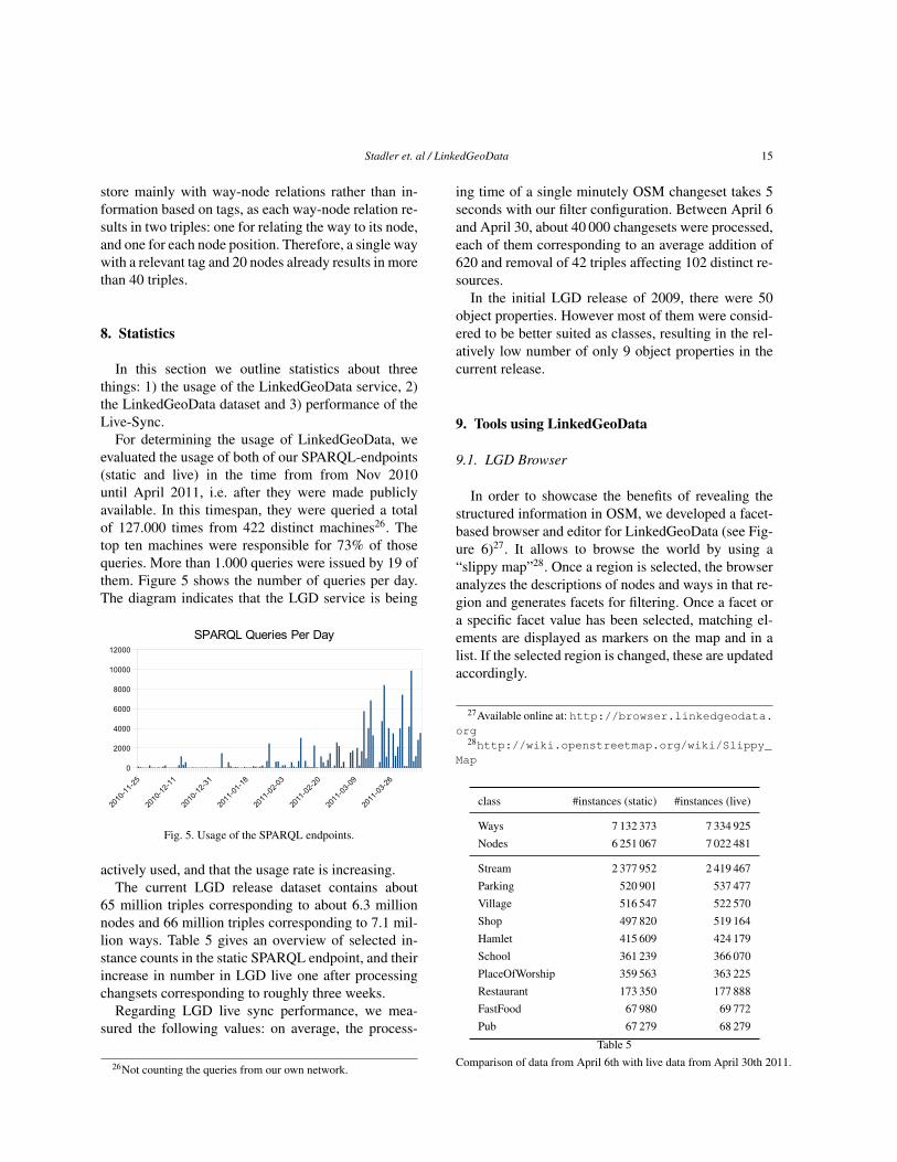
In this section we outline statistics about threethings: 1) the usage of the LinkedGeoData service, 2)the LinkedGeoData dataset and 3) performance of theLive-Sync.
For determining the usage of LinkedGeoData, weevaluated the usage of both of our SPARQL-endpoints(static and live) in the time from from Nov 2010until April 2011, i.e. after they were made publiclyavailable. In this timespan, they were queried a totalof 127.000 times from 422 distinct machines26. Thetop ten machines were responsible for 73% of thosequeries. More than 1.000 queries were issued by 19 ofthem. Figure 5 shows the number of queries per day.The diagram indicates that the LGD service is being
2010
-11-
25
2010
-12-
11
2010
-12-
31
2011
-01-
18
2011
-02-
03
2011
-02-
20
2011
-03-
09
2011
-03-
26
0
2000
4000
6000
8000
10000
12000
SPARQL Queries Per Day
Fig. 5. Usage of the SPARQL endpoints.
actively used, and that the usage rate is increasing.The current LGD release dataset contains about
65 million triples corresponding to about 6.3 millionnodes and 66 million triples corresponding to 7.1 mil-lion ways. Table 5 gives an overview of selected in-stance counts in the static SPARQL endpoint, and theirincrease in number in LGD live one after processingchangsets corresponding to roughly three weeks.
Regarding LGD live sync performance, we mea-sured the following values: on average, the process-
26Not counting the queries from our own network.
ing time of a single minutely OSM changeset takes 5seconds with our filter configuration. Between April 6and April 30, about 40 000 changesets were processed,each of them corresponding to an average addition of620 and removal of 42 triples affecting 102 distinct re-sources.
In the initial LGD release of 2009, there were 50object properties. However most of them were consid-ered to be better suited as classes, resulting in the rel-atively low number of only 9 object properties in thecurrent release.
9. Tools using LinkedGeoData
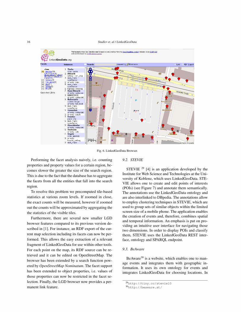
9.1. LGD Browser
In order to showcase the benefits of revealing thestructured information in OSM, we developed a facet-based browser and editor for LinkedGeoData (see Fig-ure 6)27. It allows to browse the world by using a“slippy map”28. Once a region is selected, the browseranalyzes the descriptions of nodes and ways in that re-gion and generates facets for filtering. Once a facet ora specific facet value has been selected, matching el-ements are displayed as markers on the map and in alist. If the selected region is changed, these are updatedaccordingly.
27Available online at: http://browser.linkedgeodata.org
28http://wiki.openstreetmap.org/wiki/Slippy_Map
class #instances (static) #instances (live)
Ways 7 132 373 7 334 925Nodes 6 251 067 7 022 481
Stream 2 377 952 2 419 467Parking 520 901 537 477Village 516 547 522 570Shop 497 820 519 164Hamlet 415 609 424 179School 361 239 366 070PlaceOfWorship 359 563 363 225Restaurant 173 350 177 888FastFood 67 980 69 772Pub 67 279 68 279
Table 5Comparison of data from April 6th with live data from April 30th 2011.
16 Stadler et. al / LinkedGeoData
Fig. 6. LinkedGeoData Browser.
Performing the facet analysis naively, i.e. countingproperties and property values for a certain region, be-comes slower the greater the size of the search region.This is due to the fact that the database has to aggregatethe facets from all the entities that fall into the searchregion.
To resolve this problem we precomputed tile-basedstatistics at various zoom levels. If zoomed in close,the exact counts will be measured, however if zoomedout the counts will be approximated by aggregating thethe statistics of the visible tiles.
Furthermore, there are several new smaller LGDbrowser features compared to its previous version de-scribed in [1]. For instance, an RDF export of the cur-rent map selection including its facets can now be per-formed. This allows the easy extraction of a relevantfragment of LinkedGeoData for use within other tools.For each point on the map, its RDF source can be re-trieved and it can be edited on OpenStreetMap. Thebrowser has been extended by a search function pow-ered by OpenStreetMap Nominatum. The facet supporthas been extended to object properties, i.e. values ofthose properties can now be restricted in the facet se-lection. Finally, the LGD browser now provides a per-manent link feature.
9.2. STEVIE
STEVIE 29 [4] is an application developed by theInstitute for Web Science and Technologies at the Uni-versity of Koblenz, which uses LinkedGeoData. STE-VIE allows one to create and edit points of interests(POIs) (see Figure 7) and annotate them semantically.The annotations use the LinkedGeoData ontology andare also interlinked to DBpedia. The annotations allowto employ clustering techniques in STEVIE, which areused to group sets of similar objects within the limitedscreen size of a mobile phone. The application enablesthe creation of events and, therefore, combines spatialand temporal information. An emphasis is put on pro-viding an intuitive user interface for navigating thosetwo dimensions. In order to display POIs and classifythem, STEVIE uses the LinkedGeoData REST inter-face, ontology and SPARQL endpoint.
9.3. BeAware
BeAware30 is a website, which enables one to man-age events and integrates them with geographic in-formation. It uses its own ontology for events andintegrates LinkedGeoData for choosing locations. In
29http://tiny.cc/stevie1030http://beaware.at/
Stadler et. al / LinkedGeoData 17
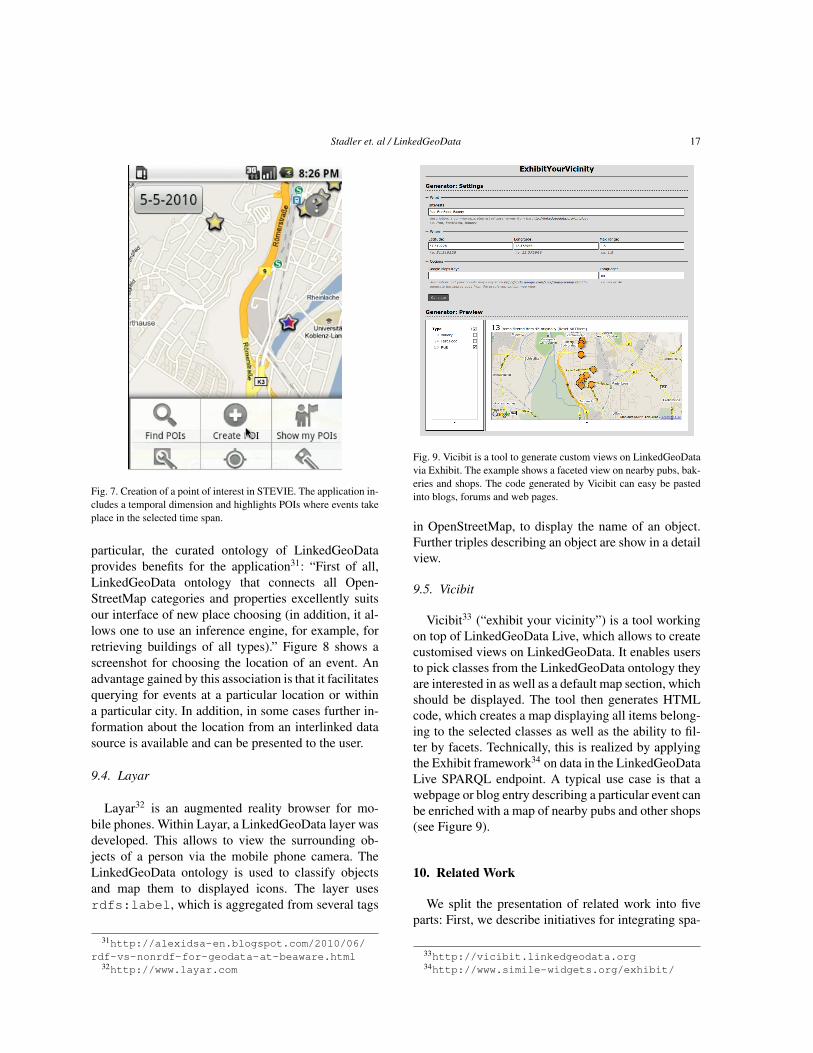
Fig. 7. Creation of a point of interest in STEVIE. The application in-cludes a temporal dimension and highlights POIs where events takeplace in the selected time span.
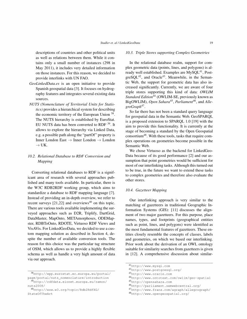
particular, the curated ontology of LinkedGeoDataprovides benefits for the application31: “First of all,LinkedGeoData ontology that connects all Open-StreetMap categories and properties excellently suitsour interface of new place choosing (in addition, it al-lows one to use an inference engine, for example, forretrieving buildings of all types).” Figure 8 shows ascreenshot for choosing the location of an event. Anadvantage gained by this association is that it facilitatesquerying for events at a particular location or withina particular city. In addition, in some cases further in-formation about the location from an interlinked datasource is available and can be presented to the user.
9.4. Layar
Layar32 is an augmented reality browser for mo-bile phones. Within Layar, a LinkedGeoData layer wasdeveloped. This allows to view the surrounding ob-jects of a person via the mobile phone camera. TheLinkedGeoData ontology is used to classify objectsand map them to displayed icons. The layer usesrdfs:label, which is aggregated from several tags
31http://alexidsa-en.blogspot.com/2010/06/rdf-vs-nonrdf-for-geodata-at-beaware.html
32http://www.layar.com
Fig. 9. Vicibit is a tool to generate custom views on LinkedGeoDatavia Exhibit. The example shows a faceted view on nearby pubs, bak-eries and shops. The code generated by Vicibit can easy be pastedinto blogs, forums and web pages.
in OpenStreetMap, to display the name of an object.Further triples describing an object are show in a detailview.
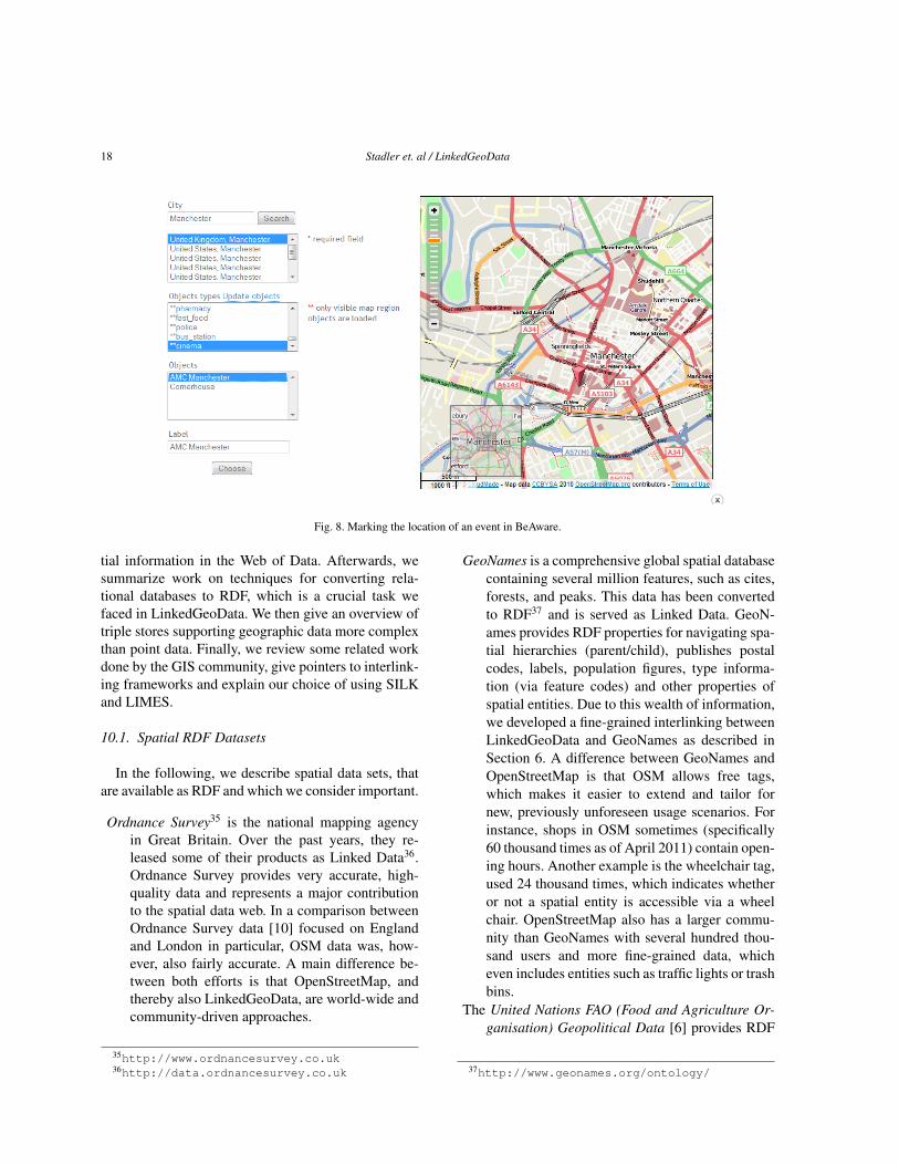
9.5. Vicibit
Vicibit33 (“exhibit your vicinity”) is a tool workingon top of LinkedGeoData Live, which allows to createcustomised views on LinkedGeoData. It enables usersto pick classes from the LinkedGeoData ontology theyare interested in as well as a default map section, whichshould be displayed. The tool then generates HTMLcode, which creates a map displaying all items belong-ing to the selected classes as well as the ability to fil-ter by facets. Technically, this is realized by applyingthe Exhibit framework34 on data in the LinkedGeoDataLive SPARQL endpoint. A typical use case is that awebpage or blog entry describing a particular event canbe enriched with a map of nearby pubs and other shops(see Figure 9).
10. Related Work
We split the presentation of related work into fiveparts: First, we describe initiatives for integrating spa-
33http://vicibit.linkedgeodata.org34http://www.simile-widgets.org/exhibit/
18 Stadler et. al / LinkedGeoData
Fig. 8. Marking the location of an event in BeAware.
tial information in the Web of Data. Afterwards, wesummarize work on techniques for converting rela-tional databases to RDF, which is a crucial task wefaced in LinkedGeoData. We then give an overview oftriple stores supporting geographic data more complexthan point data. Finally, we review some related workdone by the GIS community, give pointers to interlink-ing frameworks and explain our choice of using SILKand LIMES.
10.1. Spatial RDF Datasets
In the following, we describe spatial data sets, thatare available as RDF and which we consider important.
Ordnance Survey35 is the national mapping agencyin Great Britain. Over the past years, they re-leased some of their products as Linked Data36.Ordnance Survey provides very accurate, high-quality data and represents a major contributionto the spatial data web. In a comparison betweenOrdnance Survey data [10] focused on Englandand London in particular, OSM data was, how-ever, also fairly accurate. A main difference be-tween both efforts is that OpenStreetMap, andthereby also LinkedGeoData, are world-wide andcommunity-driven approaches.
35http://www.ordnancesurvey.co.uk36http://data.ordnancesurvey.co.uk
GeoNames is a comprehensive global spatial databasecontaining several million features, such as cites,forests, and peaks. This data has been convertedto RDF37 and is served as Linked Data. GeoN-ames provides RDF properties for navigating spa-tial hierarchies (parent/child), publishes postalcodes, labels, population figures, type informa-tion (via feature codes) and other properties ofspatial entities. Due to this wealth of information,we developed a fine-grained interlinking betweenLinkedGeoData and GeoNames as described inSection 6. A difference between GeoNames andOpenStreetMap is that OSM allows free tags,which makes it easier to extend and tailor fornew, previously unforeseen usage scenarios. Forinstance, shops in OSM sometimes (specifically60 thousand times as of April 2011) contain open-ing hours. Another example is the wheelchair tag,used 24 thousand times, which indicates whetheror not a spatial entity is accessible via a wheelchair. OpenStreetMap also has a larger commu-nity than GeoNames with several hundred thou-sand users and more fine-grained data, whicheven includes entities such as traffic lights or trashbins.
The United Nations FAO (Food and Agriculture Or-ganisation) Geopolitical Data [6] provides RDF
37http://www.geonames.org/ontology/
Stadler et. al / LinkedGeoData 19
descriptions of countries and other political unitsas well as relations between them. While it con-tains only a small number of instances (298 inMay 2011), it includes very detailed informationon those instances. For this reason, we decided toprovide interlinks with UN FAO.
GeoLinkedData.es is an open initiative to provideSpanish geospatial data [3]. It focuses on hydrog-raphy features and integrates several existing datasources.
NUTS (Nomenclature of Territorial Units for Statis-tics) provides a hierarchical system for describingthe economic territory of the European Union 38.The NUTS hierarchy is established by EuroStat.EU NUTS data has been converted to RDF 39. Itallows to explore the hierarchy via Linked Data,e.g. a possible path along the “partOf” property isInner London East → Inner London → London→ UK.
10.2. Relational Database to RDF Conversion andMapping
Converting relational databases to RDF is a signif-icant area of research with several approaches pub-lished and many tools available. In particular, there isthe W3C RDB2RDF working group, which aims tostandardize a database to RDF mapping language [7].Instead of providing an in-depth overview, we refer torecent surveys [21,22] and overviews40 on this topic.There are various tools available implementing the sur-veyed approaches such as D2R, Triplify, DartGrid,DataMaster, MapOnto, METAmorphoses, ODEMap-ster, RDBToOnto, RDOTE, Virtuoso RDF Views andVisAVis. For LinkedGeoData, we decided to use a cus-tom mapping solution as described in Section 4, de-spite the number of available conversion tools. Thereason for this choice was the particular tag structureof OSM, which allows us to provide a highly flexibleschema as well as handle a very high amount of datavia our approach.
38http://epp.eurostat.ec.europa.eu/portal/page/portal/nuts_nomenclature/introduction
39http://rdfdata.eionet.europa.eu/ramon/nuts2008/
40http://esw.w3.org/topic/Rdb2RdfXG/StateOfTheArt
10.3. Triple Stores supporting Complex Geometries
In the relational database realm, support for com-plex geometric data (points, lines, and polygons) is al-ready well established. Examples are MySQL41, Post-greSQL42, and Oracle43. Meanwhile, in the Seman-tic Web, the support for geometric data has also in-creased significantly. Currently, we are aware of fourtriple stores supporting this kind of data: OWLIMStandard Edition44 (OWLIM-SE, previously known asBigOWLIM), Open Sahara45, Parliament46, and Alle-groGraph47.
So far there has not been a standard query languagefor geospatial data in the Semantic Web. GeoSPARQLis a proposed extension to SPARQL 1.0 [19] with theaim to provide this functionality. It is currently at thestage of becoming a standard by the Open Geospatialconsortium48. With these tools, tasks that require com-plex operations on geometries become possible in theSemantic Web.
We chose Virtuoso as the backend for LinkedGeo-Data because of its good performance [2] and our as-sumption that point geometries would be sufficient formost of our interlinking tasks. Although this turned outto be true, in the future we want to extend these tasksto complex geometries and therefore also evaluate theother stores.
10.4. Gazetteer Mapping
Our interlinking approach is very similar to thematching of gazetteers in traditional Geographic In-formation Systems (GIS): [11] discusses the align-ment of two major gazetteers. For this purpose, placenames, types, and footprints (geographical entitiessuch as point, lines, and polygons) were identified asthe most fundamental features of gazetteers. These en-tities closely resemble the concepts of classes, labelsand geometries, on which we based our interlinking.Prior work about the derivation of an OWL ontologysuitable for similarity searches from gazetteers is givenin [12]. A comprehensive discussion about similar-
41http://www.mysql.com42http://www.postgresql.org/43http://www.oracle.com44http://www.ontotext.com/owlim/geo-spatial45http://opensahara.com46http://parliament.semwebcentral.org/47http://www.franz.com/agraph/allegrograph/48http://www.opengeospatial.org/
20 Stadler et. al / LinkedGeoData
ity search paradigms for Description Logics is lead in[13].
10.5. Interlinking and Ontology Mapping
There have been several decades of research start-ing with the integration of different database schemata.Tools like COMA [8] provide rich support for variousmatching operations between databases as well as be-tween RDF knowledge bases. [5] describes a semanticapproach for matching export schemas of geographicaldatabase Web services, based on the use of a small setof typical instances. The paper also contains an exten-sive experiment, carried out within the context of twogazetteers, GeoNames, and the ADL gazetteer, to illus-trate the idea. [15] describes an approach integratingspatial data from multiple sources, which also incorpo-rates a temporal dimension. For interlinking Linked-GeoData, we mainly searched for instance matchingtools, since our main goal is to match specific pointsof interests in different knowledge bases. In this area,SILK and LIMES are the most widely used applica-tions. We extended SILK with an appropriate met-ric for matchings based on WGS84 distance betweenpoints, which was later included in the official SILKrelease. A main benefit for SILK as well as LIMES,which we both use, is their ability to handle largevolumes of data and use SPARQL endpoints as inputsource.
11. Conclusions and Future Work
The transformation and publication of the Open-StreetMap data according to the Linked Data prin-ciples adds a new dimension to the Data Web: spa-tial data can be retrieved and interlinked on an un-precedented level of granularity. These enhancementsmay further contribute to semantic-spatial search en-gines, such as [13,20], and enable a variety of newLinked Data applications such as geo-data syndica-tion (publishing information about geographical enti-ties via feeds). Another example is personalized andcontext-sensitive spatial Linked Data update propaga-tion and consumption, which might be realized withsystems such as sparqlPuSH [18].
The dynamics of the OpenStreetMap project willensure a steady growth of the LinkedGeoData dataset.Furthermore, we established mappings with DBpediaand GeoNames as the central interlinking hubs for spa-tial information on the Web of Data. Despite the re-
cent advances in RDF data management, it becameclear during our work on LinkedGeoData that spatialdata of the size of OpenStreetMap still poses a majorchallenge wrt. scalability. Substantial engineering ef-fort was required to optimize the performance of thequerying interfaces, live synchronization, as well asthe interlinking.
Currently, our transformation approach imposes thefollowing limitations on the use of LinkedGeoData:
– The current ontology is mainly automatically de-rived from OpenStreetMap tags, with mostly justminor manual edits. However, it could benefitfrom axiomatizations, such that, for example,any PlaceOfWorship with religion christian is aChurch. The extent to which the addition of dis-jointness axioms makes sense needs yet to be in-vestigated. For instance, currently instances cor-responding to hotels that also offer a restaurantare currently tagged with both types. However, analternative solution would be to model such in-stance as a Hotel, that offers a feature that is aRestaurant. For these kinds of design decisions,we envision a solution similar to the DBpediaMapping Wiki49, that enables the community tocontribute to the axiomatization of the ontology.
– Our filtering (see Section 7.5) currently discardsa significant amount of data from OSM. Hence,there are use cases that are possible with OSMdata, but not with LinkedGeoData yet. For exam-ple, since we filter out ways with more than 20nodes, routing50 is currently not possible based onthe LinkedGeoData SPARQL endpoints.
– Because we do not support OpenStreetMap rela-tions yet, information about compound entities isalso not yet available in LinkedGeoData. Exam-ples of such entities are: multipolygons (collec-tions of polygons, where each member may acteither as solid or as a hole), or designation signs.Further examples include large boundaries, wa-terways, and routes, that are modelled with waysegments.
As for the latter two limitations, we are currentlyinvestigating whether and how these limitations canbe overcome by directly rewriting SPARQL queriesto SQL queries over the relational schema of Open-StreetMap. Although substantial progress was made inRDB-RDF mapping during the last years, and imple-
49http://mappings.dbpedia.org50http://wiki.openstreetmap.org/wiki/Routing
Stadler et. al / LinkedGeoData 21
mentations are now more robust, scalability and thelack of support for geometry datatypes is still an issuepreventing a direct deployment of these technologiesfor LinkedGeoData.
Another stream of future work is the better supportfor geometries according to the current NeoGeoVocab-ulary development51, which we are supporting. A se-mantic misrepresentation currently found in Linked-GeoData, for example, is the missing separation of ge-ometries (such as points and polygons) and features(such as hotels and pubs), which we plan to resolve inthe future.
Finally, we identified further candidates that seemworthwhile for interlinking:
– The CIA World Factbook52 contains detailed in-formation on the country level, such as their con-ventional names, their birthrate, and their grossdomestic product. An RDF version is hosted bythe Free University of Berlin53.
– The site climb.dataincubator.org hostsa collection of data of about 1400 climbing lo-cations with latitude/longitude information. Theresources were collected from various climbingweb sites and converted to RDF.
– Last.fm54 has information about music artists, aswell as events, such as performances and festi-vals. Many event locations are geo-tagged, mak-ing them suitable candidates for interlinking.There exist at least two wrappers for the last.fmAPI that return RDF55.
Acknowledgments
We would like to thank OpenLink for providing anenterprise edition of the Virtuoso database system thatoffers support for spatial SPARQL queries. Further-more, the authors thank the members of the Linked-GeoData community and 3rd party application devel-opers for their valuable feedback and contributions tothe project. In particular, we would like to mentionRobert Schulze for his work on Vicibit. This workwas supported by a grant from the European Union’s7th Framework Programme provided for the projectsLOD2 (GA no. 257943) and LATC (GA no. 256975).
51http://geovocab.org/doc/neogeo.html52https://www.cia.gov/library/publications/
the-world-factbook/53http://www4.wiwiss.fu-berlin.de/factbook/54http://last.fm55dbtune.org/last-fm/ and lastfm.rdfize.com/
References
[1] S. Auer, J. Lehmann, and S. Hellmann. LinkedGeoData -adding a spatial dimension to the web of data. In Proc. of 8thInternational Semantic Web Conference (ISWC), 2009.
[2] C. Bizer and A. Schultz. The berlin sparql benchmark. Int. J.Semantic Web Inf. Syst., 5(2):1–24, 2009.
[3] L. M. V. Blázquez, B. Villazón-Terrazas, V. Saquicela,A. de León, Ó. Corcho, and A. Gómez-Pérez. Geolinked dataand INSPIRE through an application case. In D. Agrawal,P. Zhang, A. E. Abbadi, and M. F. Mokbel, editors, 18th ACMSIGSPATIAL International Symposium on Advances in Geo-graphic Information Systems, ACM-GIS 2010, November 3-5,2010, San Jose, CA, USA, Proceedings, pages 446–449. ACM,2010.
[4] M. Braun, A. Scherp, and S. Staab. Collaborative creationof semantic points of interest as linked data on the mobilephone. In Extended Semantic Web Conference (Demo Session).Springer, 2010.
[5] D. F. Brauner, C. Intrator, J. C. Freitas, and M. A. Casanova.An instance-based approach for matching export schemas ofgeographical database Web services. In Proc. of the IX Brazil-ian Symp. on GeoInformatics (GEOINFO), pages 109–120,2007.
[6] C. Caracciolo, M. I. Sucasas, and J. Keizer. Towards interop-erability of geopolitical information within FAO. Computingand Informatics, 27(1):119–129, 2008.
[7] S. Das, S. Sundara, and R. Cyganiak. R2RML: RDB to RDFmapping language. World Wide Web Consortium, WorkingDraft WD-r2rml-20110324, Mar. 2011.
[8] H. H. Do and E. Rahm. COMA - A system for flexible combi-nation of schema matching approaches. In VLDB, pages 610–621. Morgan Kaufmann, 2002.
[9] M. Goodchild. Citizens as sensors: the world of volunteeredgeography. GeoJournal, 69(4):211–221, Aug. 2007.
[10] M. Haklay. How good is volunteered geographical informa-tion? A comparative study of openstreetmap and ordnance sur-vey datasets. Environment and Planning B: Planning and De-sign, pages 682–703, July 2010.
[11] L. L. Hill. Core elements of digital gazetteers: Placenames,categories, and footprints. In J. L. Borbinha and T. Baker, ed-itors, ECDL, volume 1923 of Lecture Notes in Computer Sci-ence, pages 280–290. Springer, 2000.
[12] K. Janowicz and C. Keßler. The role of ontology in improvinggazetteer interaction. International Journal of GeographicalInformation Science, 22(10):1129–1157, 2008.
[13] K. Janowicz, M. Wilkes, and M. Lutz. Similarity-based infor-mation retrieval and its role within spatial data infrastructures.In T. J. Cova, H. J. Miller, K. Beard, A. U. Frank, and M. F.Goodchild, editors, GIScience, volume 5266 of Lecture Notesin Computer Science, pages 151–167. Springer, 2008.
[14] J. Lehmann, C. Bizer, G. Kobilarov, S. Auer, C. Becker, R. Cy-ganiak, and S. Hellmann. DBpedia - a crystallization pointfor the web of data. Journal of Web Semantics, 7(3):154–165,2009.
[15] H. Manguinhas, B. Martins, and J. L. Borbinha. A geo-temporal web gazetteer integrating data from multiple sources.In ICDIM, pages 146–153. IEEE, 2008.
[16] D. G. McVitie and L. B. Wilson. The stable marriage problem.Commun. ACM, 14(7):486–490, 1971.
22 Stadler et. al / LinkedGeoData
[17] A.-C. Ngonga Ngomo and S. Auer. Limes - a time-efficientapproach for large-scale link discovery on the web of data. InProceedings of IJCAI, 2011.
[18] A. Passant and P. Mendes. sparqlPuSH: Proactive notificationof data updates in RDF stores using PubSubHubbub. volume699 of CEUR Workshop Proceedings ISSN 1613-0073, Febru-ary 2010.
[19] E. Prud’hommeaux and A. Seaborne. SPARQL Query Lan-guage for RDF. W3C Recommendation, 2008. http://www.w3.org/TR/rdf-sparql-query/.
[20] R. S. Purves, P. Clough, C. B. Jones, A. Arampatzis, B. Bucher,D. Finch, G. Fu, H. Joho, A. K. Syed, S. Vaid, and B. Yang. Thedesign and implementation of spirit: a spatially aware searchengine for information retrieval on the internet. InternationalJournal of Geographical Information Science, 21(7):717–745,2007.
[21] S. S. Sahoo, W. Halb, S. Hellmann, K. Idehen, T. T. Jr, S. Auer,J. Sequeda, and A. Ezzat. A survey of current approaches formapping of relational databases to rdf, 01 2009.
[22] D.-E. Spanos, P. Stavrou, and N. Mitrou. Bringing relationaldatabases into the semantic web: A survey. Semantic Web Jour-nal. under review.
[23] C. Stadler, M. Martin, J. Lehmann, and S. Hellmann. UpdateStrategies for DBpedia Live. In 6th Workshop on Scriptingand Development for the Semantic Web Colocated with ESWC2010 30th or 31st May, 2010 Crete, Greece, 2010.
[24] J. Volz, C. Bizer, M. Gaedke, and G. Kobilarov. Silk–a linkdiscovery framework for the web of data. In Proceedings of the
2nd Workshop about Linked Data on the Web (LDOW2009),2009.
[25] W. Winkler. The state of record linkage and current researchproblems. Technical report, U.S. Bureau of the Census, 1999.
Appendix
A. Prefixes Used
The following prefixes are used in the paper:
1 lgd: http://linkedgeodata.org/triplify/2 lgdo: http://linkedgeodata.org/ontology/3 wgs84: http://www.w3.org/2003/01/geo/wgs84_pos#4 foa: http://www.fao.org/countryprofiles/geoinfo
/geopolitical/resource/5 dbpedia: http://dbpedia.org/resource/6 rdf: http://www.w3.org/1999/02/22-rdf-syntax-
ns#7 rdfs: http://www.w3.org/2000/01/rdf-schema#8 owl: http://www.w3.org/2002/07/owl#9 xsd: http://www.w3.org/2001/XMLSchema#
10 georss: http://www.georss.org/georss/