Liard River Hydroelectric Studies - arlis.org RIVER HYDROELECTRIC STUDIES ... western half of the...
23
®BCHydro Liard River Hydroelectric Studies Information Bulletin No.4 December 1982 Community Relations Department 970 Burrard St reet Vancouver, B.C. V6Z IY3
Transcript of Liard River Hydroelectric Studies - arlis.org RIVER HYDROELECTRIC STUDIES ... western half of the...

®BCHydro
Liard River Hydroelectric Studies
Information Bulletin No.4 December 1982
Community Relations Department 970 Burrard Street Vancouver, B.C. V6Z IY3
TR23
Section
1.0
2. 0
3.0
4 .0
5.0
6. 0
Figure No.
1 2 3 4
LIARD RIVER HYDROELECTRIC STUDIES INFORMATION BULLETIN NO. 4
COI:TENTS
Subject
INTRODUCTION
STATUS OF LIARD DEVELOPMENT
PLANNING AND LICENSING
(a) The Planning Process (b) Public Consultation (c) The Project Certification Procedure
ENGINEERING STUDIES
(a) Study Region (b) Alternative Development Schemes
ENVIRONMENTAL AND SOCIO-ECONOMIC STUDIES
(a) Studies Upstream of Beavercrow (b) Studi es Downstream of Beavercrow
TRANSMISSION STUDIES
FIGURES
Liard-Mackenzie River System Project Area River Profile Transmission Line Study Corridors
- i -
Page
1
1
2 3 4
5 6
9
9 11
14
ISSN 0228 -9377

1.0 INTRODUCTION
This is the fourth information bulletin on B.C. Hydro ' s inve~tigations
of the hydroelectric power potential of the liard River.
The earlier information bulletins were issued in February 1979,
September 1979, and March 1981. Copies are available upon request.
Hydro 'S in its fifth year of studies of the engineering and environ
mental feasibility of developing the hydroelectric potential of the
Liard River. This bulletin outlines the nature of these investigations,
and describes some preliminary findings.
For further ~nformation, please contact:
Community Relations S.C. Hydro 970 Burrard Street Vancouver , B.C. VoZ 1Y3
or te 1 ephone ( o 11 ect): 604-663-2405.
2.0 STATUS OF LIARD DEVELOPMENT
The Liard River studies program was cut back in 1982 as a result of
reductions in the electrical lean forecast for British Columbia and
financial restraints implemented during the year by B.C. Hydro. Major
segments of the program planned for 1982 were deferred. However, some
of the field studies in progress at the time of the cutback were
continued. At the present time it appears that the restraints on the
liard study program wi 11 continue through 1983 and possibly 1 onger.
TR23 - 1 -

TR23
Studies completed to date show that the liard River development would
provide more power, at lower unit cost , than any other river basin
currently unrler investigation in British Columbia. However, recent
long-range projections of B.C . Hydro system requirements indicate that
po~er from the Liard would not be needed until the year 2000 or later, a
deferral of at least two years from previous estimates.
No decision has been made by B.C. Hydro whether or not to 1pply for
regulatory approval for any of the Liard River projects, and such a
decision will not likely be made for some time. On the basis of an
assumed year 2000 in-service date , B.C. Hydro would need to apply by
1988 to allow sufficient time for regulatory reviews and, if the
development were approved, construction of the first project and
associated transmission facilities.
As a result of the s lowdown i n the Liard program, work in 1983 will
consist mainly of office studies . Engineering site explorations and
environmental fie ld studies previously planned for 1983 have been
deferred. However, a limited program of hydrological and environmental
data collection will continue, to provide additional information for the
environmental impact assessment studies when they resume.
3.0 PLANNING AND LICENSING
(a) The Planning Process
It takes 10 to 20 years to plan, design, li cense and build a major
hydroelectric project. For thi s reason, Hydro must look years
ahead in examining potential sites . When the need arises for more
electricity, projects must be operating to meet that need. There
fore, Hydro's plans must be flexible enough to accommodate events
such as a change in electrical demand or the loss of a project (due
- 2 -

TR23
to high cost, environmental or other factors, or rejection at the
licensing stage).
Hydro selects a sequence of projects to meet projected electricity
needs . This sequence is reviewed annually, and adjusted if neces
sary, in the light of new information about projects and electrical
demand. Lower-cost energy sources, assuming they could be built in
time to meet expected electrical demand, are generally schec1uled
first. Such scheduling is in keeping with Hydro's objective of
sup~lying electricity at the lowest long-term cost to British
Columbia customers.
(b) Public Consultation
During the planning of potential new projects, B.C. Hydro carries
out a publ~c consultation program to discuss its studies and
preliminary plans with interested parties. The public consultation
program for the Liard River hydroelec~ric development provides for
participation by government representatives, 1 oca l interest groups
and the general public. The program's objectives are:
1. to ensure that interested members of the public are informed
about the proposed development;
2. to provide opportunities for the public to consult with Hydt·o
representatives about the implications of the proposal;
3. to enabl e Hydro to work with representatives of the public in
dealing with i ssues pertaining to the proposal, and
4. to assist Hydro in obtaining the information necessary to make
informed, responsive decisions.
- 3 -

TR23
(c) The Project Certification Procedure
(i) Regulatory Approvals
For Hydro to proceed with construct ion of a major hydro
electric generation or transmission project, it must obtain
various approvals, certificates , permits and licences.
Depending upon the 1 ocat ion, nature and scope of the hydro
electric generation project, provincial statutes which may
apply i ncl ude the Utilities Commission Act, the Water Act, the
Agricultural Land Commission Act, the Heritage Conservation
Act, the Park Act, the Environment and Land Use Act, the Highway Act, the Envi ronment Management Act and the Forest
Act.
Federal statutes which may apply include the Navigabl e Waters
Protection Act, the Fisheries Act, the Indian Act, the
Northe rn Inland Waters Act and the Canada Water Act.
For certain projects only some of these statutes would be
applicable while for others, such as the Liard project, it is
anticipated that most or all of the approvals required by the
above statutes might be involved.
(ii) The Provincial Energy Review Process
The Utilities Commissi on Act established a comprehensive
mechanism for decision-making on major energy projects. Major
hydroelectric generation projects and 500 kilovolt
(kV = 1000 volts) transmission lines are subject to review by
and decisions of the Mini ster of Energy, Mines and Petroleum
Resources, the B.C. Utilities Commission and the Provincial
- 4 -

TR23
Cabinet, in accordance with the p;ocess es tab 1 i shed by the
Utilities Commission Act.
The Act requires that an applicant for d project provide
certain detailed information and an analysis of the impacts
created by the project. It makes provisions for a pub 1 i c
hearing process which can allow for input from the general
public and other interested parties. The Act also provides
that the Commission will report and make recommendations after
s uch hearings. On receiving the report and recommendations of
the Commission , the Cabinet will decide whet~er t o approve or
reject the proposal and may set down terms and conditions that
it believes to be appropriate.
4.0 ENGI NEERING STUDIES
(a) Study Region
The Liard River rises in the Yukon and flows southeasterly into
British Columbia near Lower Post. The river flows in an easterly
direction t hrough British Columbia for about 480 kilometres
(km = 5/8 mile) before crossing into the Northwest Territories . A
further 370 km downstream, the Liard di scharges into the Mackenzie
River at Fort Simpson. From there, the Mackenzi e flows 1390 km to
the Beaufort Sea. (See Fig. 1).
The Alaska Highway runs parallel to the Li ard River over the
western half of the river ' s course through British Columbia, as
shown in Fig. 2. The principal sett lements and facilities in the
Liard s tudy area are located along the highway. Two communities,
Lower Post, B.C., and Upper Liard, Y.T., are located near the
B. C. - Yukon boundary. The residents of these communities are
predominantly native Indians belonging to the Liard River Band
- 5 -

TR23
(1975 popu 1 at ion, 595). The Muddy River Indian Reserve, 1 ocated
near the confluence of the Liard and Kechi~a rivers, has an area of
71 hectares (ha = 2. 47 acres). The Liard River Hot Springs and the
associated 670 ha Class A provincial park are located at Mil e 496
of the A 1 aska Highway, near Lower Liard Crossing. Large areas
between Lower Post and Liard River Hot Springs park were burned by forest fires in 1982.
(b) Alternative Development Schemes
The Liard River development, consisti ng of projects at Devils Gorge
and Beavercrow, could provide an installed capacity of about
4410 megawatts (MW = 1 mi 11 ion watts ) and generate about 26 000
gigawatt-hours (GW.h = 1 million kilowatt-hours) of electricity
annually. This is greater than the combined output of B.C. Hydro 's
two largest generating stations G.M. Shrum on the Peace River
and Mica on the Columbia River.
The decision to select the Devils Gorge and Beavercrow scheme for
detailed investigation was based on preliminary studies of
11 potential development schemes involving various combinations of
six project s ites. Studies of alternative project combinations are
reviewed and brought up-to-date from time to time for comparison
with the Devils Gorge-Beavercrow scheme.
The Devils Gorge (572) project would form a reservoir extending
upstream to a point near Lower Post, and Beavercrow (390) would
impound water back to Devils Gorge. [Numbers in brackets refer to
the nominal maximum normal reservoir elevations, expressed in
metres (m = 3.28 feet) above sea level. l Devils Gorge, previously
ca 11 ed Site E, is 1 ocated at the head of the Grand Canyon of the
Liard approximately 25 km downstream from Lower Liard Crossing,
while Beavercrow, previously called Site A, is about 110 km
upstream from the B.C.-N.W.T. boundary.
- 6 -

TR23
Due to the nature of the foundation rock at Beavercrow there may be
advantages in deve 1 oping the river with a three-project scheme
rather than with the two-project scheme described above. The
three-project scheme would include projects at Devils Gorge (572) ,
Hell Gate (390) and Beavercrow (342). The Devils Gorge dam would
be i dent i ca 1 to the one in the two-project scheme, whi 1 e the
Beavercrow dam would be approximately 48 m lower than in the
two-project scheme . The profile of the river (Fig. 3) shows the
differences in the two schemes. Preliminary s tudies of the three
project scheme indicate that it would produce slightly less energy
than the two-project scheme but might have certain offsetting
benefits. Following are descriptions of the components of the two
schemes.
(i) Devils Gorge (572) Project
The Devils Gorge site is located approx imately 25 km down
s tream from Lower Liard Crossing at the upstream end of the
Grand Canyon of the Liard. Facilities at this site would
consist of an earthfill dam, 200m high, an underground power
house with a capacity of 2490 MW and a gated concrete spill
way. Two saddle dams would be required on the perimeter of
the reservoir, one 4 km east and the other 8 km southwest of
the main dam.
Devils Gorge reservoir would have a surface area of about
890 square kilometres (km2 = 0.3861 mile2) and would be 240 km
long at the normal maximum elevation. It would provide
21 x 109 m3 of usable water storage capacity, slightly more
than half that of Willi ston Lake, the largest reservoir in
British Columbia.
The Devils Gorge reservoir would store water during the
spring - summer high runoff period, and the stored water would
- 7 -
TR23
be discharged through the turbines during the 10\·1-flow fall
winter period. In a year of average runoff in the Liard River
basin, the lowest water level in the Devils Gorge reservoir
would be about 17 m below normal maximum reservoir level.
Maximum drawdown in a year of extreme low flows would be 30 m.
Normally the Devils Gorge reservoir would reach its lowest
level of the year in Apri 1, just before the onset of spring
runoff. The reservoir would fill or reach its highest level
in late summer or early fall.
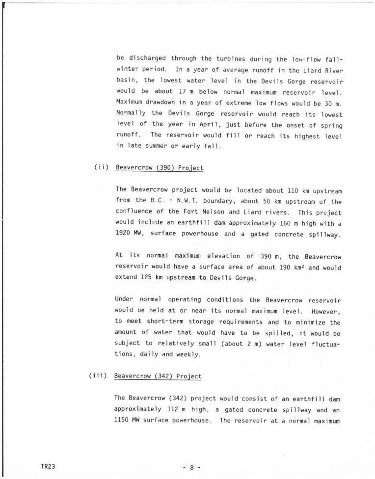
(ii) Beavercrow (390) Project
The Beavercrow project would be located about 110 km upstream
from the B.C. - N.W.T. boundary, about 50 km upstream of the
confluence of the Fort Nel son and liard rivers. This prcject
would incla!de an earthfill dam approximately 160m high with a
1920 MW, surface powerhouse and a gated concrete spillway.
At its normal maximum elevation of 390 m, the Beavercrow
reservoir would have a surface area of about 190 km2 and would
extend 125 km upstream to Devils Gorge.
Under normal opera ting conditions the Beavercrow reservoir
would be held at or near its normal maximum level. However,
to meet short- term storage requirements and to mini mize the
amount of water that would have to be spi 11 ed, it would be
subject to relatively small (about 2 m) water level fluctua
tions, daily and weekly.
(iii) Beavercrow (342) Project
The Beavercrow (342) project would consist of an earthfill dam
approximately 112m high, a gated concrete spillway and an
1150 MW surface powerhouse. The reservoir at a normal maximum
- 8 -

TR23
level of 342m would extend to Hell Gate. Reservoir operating
conditions would be the same as for Beavercrow (390).
(iv) Hell Gate (390) Project
Hell Gate is located about 40 km downst:eam from Devils Gorge
and 85 km upstream of Beavercrow. Facilities at this site
would include a concrete gravity dam and gated spillway and a
720 MW surface powerhouse. The reservoir at a normal maximum
elevation of 390m would extend back to Devils Gorge.
S.O ENVIRONMENTAL AND SOCIO-ECONOMIC STUDIES
(a) Studies Upstream of Beavercrow
1. Physical Terrain and soil mapping of the Liard River
valley has been completed and the information will be used in
various other studies, including those concerning highway and
access route location. B.C. Hydro plans to continue collect
; ng informati on about sediment, temperature and other hydro
logical matters. Further studies on the physical character
istics of the proposed reservoirs have been deferred.
Binlnoical Fisheripc: ~t:.:~~c::. 1n the upper Liard dra inage
have been completed. Eighteen species of fish occur naturally
in the rivers and smaller tributaries. At least 14 species
are expecterl to be able to colonize the proposed reservoirs;
whitefish and longnose suckers would probably be the dominant
ones. The 1 a rgP drawdown zone of the Dev i 1 s Gorge storage
reservoir would be an impediment to productivity; most fish
species wou1u rely on inflowing tributaries for spawning and
rearing habitat. Large proportions of whitefish in the
- 9 -

3.
drainage have been found to harbour tapeworm cysts
(Triaenophorus species, not infective lo humans).
Studies of wildlife and wildlife habitat are near completion.
Although detailed mapping and study of wildlife habita·:s
within the future reservoir area have been completed, the;e
and other studies such as those concerning forestry will
likely have to be revised due to the changes in vegetation
caused by extensive forest fires in mid-1982 .
Socio-Economic A preliminary :;tudy of suitabl e sites .1nd
corridors for location and relocation of highways, acc·'!ss
roads, construction camps and towns i tes is being comp 1 eted .
Several potentially suitable corridors for relocation of the
Alaska Highway have tentatively been identified, based on
er.gi neeri ng, economic and envi ronmenta 1 cons ide rat i C•ns.
Specific alignments would be examined in detail in later
investigations. Severa l sections of the existing Alaska
Highway and several small settlements wou ld require reloca
tion, but Lower Post and Upper Liard would not be flood·~d.
Heritage resource surveys have been undertaken throughout the
parts of the the Liard River valley that wou ·l d be flooded.
Prehistoric artifacts are sparse throughout the area but
relatively more numerous at the confluences of major streams.
A prehistoric quarry was found close to the Devils Gor!Je
damsite. The remains of Fort Halkett , established at the
mouth of the Smith River during the fur trade era, form tt1e
most significant historic discovery recorded to date.
No further socio- economic studies within B.C. have take1
place, although liaison has been maintained with communitie:;
close to the project areas.
- 10 -

TR2::S
(b) Studies Downstream of Beavercrow
1. Physical Hydrological studies have been done of the Liard
River below Beavercrow, the mainstem Mackenzie River below the
Liard confl uence, the Mackenzie delta and adjacent portions of
the Beaufort Sea. B. C. Hydro has maintained a program of
hydrological data collection in addition to making use of
information collected by various federal government agencies.
The effects of the proposed hydroelectric devel opment would
generally be to reduce high summer flood peaks and increase
low winter flows. The effects would diminish with distance
downstream from the Beavercrow damsite. Summer flows in the
Liard near its confluence with the Mackenzie would average
approximately 40 percent lower than non-regulated summer
flows, while winter flows would be increased by three to four
times. Summer flows in the Mackenzie River just above the
delta would be reduced by about 15 percent, while winter flows
would be increased by 30 to 40 percent. Considerable vari- \
ation in flows, sediments and ice occurs within the present
system from year to year. This would continue to occur if
hydroelectric development took place; however, there would be
changes in the timing and degree of the variations.
Although the Liard is a major contributor of suspended
sediment to the MacKenzie system, much of the suspended
sediment in the Liard River originates in tributaries below
the Beavercrow site. Construction of impoundments on the
Liard is expected to reduce average suspended sediments in the
lower Liard by about 20 percent. A 10 percent reduction in
suspended sediments in the Mackenzie River and delta is
predicted on the basis of the pre 1 i mi na1·y studies .
- 11 -

TR23
B.C. Hydro has recorded water levels in the Mackenzie delta
since the beginning of 1981. Fluctuations in various types of
1 akes and sma 11 channe 1 s are monitored throughout the open
water season. This information is being used to study the
distribution and seasonal changes in delta vegetation, and to
predict how vegetation and wildlife habitats might change
following liard River flow regulation.
Extensive investigations of annual break-up and freeze-up on
the liard and Mackenzie rivers and in the delta have been
undertaken. Under regulated conditions break-up near Fort
liard would probably occur from 1 to 2 weeks earlier, while
freeze-up would take place 3 to 4 weeks later than under
natural conditions. Break-up and freeze-up dates on the
Mackenzie River are not expected to change by more than 2 or
3 days . Observations of break-up and freeze-up are continu
ing. Satellite imagery of the Beaufort Sea is being used as a
means of studying any possible effects of Mackenzie River flow
changes on the seasonal distribution of ice along the coast
and in the offshore areas north of the delta.
2. Biological Detailed mapping of vegetation in seven study
areas in the Mackenzie delta has been completed, and factors
such as sedimentation rates , flooding frequency, and various
plant and lake characteristics have been measured. Studies of
colonization of point bars by wi llow seedlings are being
undertaken.
Studies of muskrats and waterfowl in the Mackenzie delta have
been under way since spring 1982. The major objectives are to
relate the distribution, local abundance, breeding success and
other population parameters to hydrological and vegetational
characteristics . Studies may not extend beyond 1982, due to
the present fiscal restraint program, but may be resumed
- 12 -

TR23
later. Surveys of the migratory waterfowl populations using
the Mackenzie River valley as a flyway were undertaken in 1981
and 1982. The largest concentrations of geese and ducks tend
to make use of the valley during the annual spring break-up.
Fisheries studies have proceeded throughout the lower Liard
River, the Mackenzie River, and in specific study areas in the
Mackenzie delta. The Beavercrow dam would block upstream
migrations of some fish such as Arctic cisco and inconnu, and
flow changes within the mainstem Liard may affect habitats of
some species. Fish habitat changes in the mainstem Mackenzie)
would be expected to be small in relation to naturally
occurring variations. The main aspects being studied in
Mackenzie delta lakes include seasonal influx of nutrients
following flooding, movements of young and adult fish into and
out of the lakes, and the productivity of lakes, some of which
are flooded annually, others periodically and some very
seldom.
3. Socio-Economic - A preliminary socio-economic study of
N.W. T. communities along the Liard and Mackenzie is being
comp 1 eted, based on pub 1 i shed and other data in federa 1 and
territorial government files . The purpose of this study is
to identify communities, areas and resources which would be
affected by the proposed project, and to enable B.C. Hydro to
formulate detailed study plans. Detailed socio-economic
studies have been deferred for the present, pending further
project decisions. Extensive liaison with communities in the
N.W.T. would be part of the eventual detailed socio-economic
study program.
- 13 -

6.0 TRANSMISSION STUDIES
Extra high-voltage transmission lines would be needed to take pQwer
generated by the Liard River development to the existing province-wide
transmission network. Liard transmission probably would be connected to
the provincial system in the Prince George area .
TR23
Transmission systems rated at 500 kV, 800 kV and 1000 kV are being
considered, as well as direct current systems that would take Liard
power directly to the Lower Mainland. At present, the most favourable
alternative appears to be three 500 kV lines. However, more study would
be required before a final decision could be made on transmission
voltage, type and number of lines.
The choice of transmission routes (see Fig. 4) would depend on the
environmental and social impacts, transmission line design and construc
tion constraints, costs, and long- range requirements of the provincia l
electric system.
An overview study ident ifying potential transmission line corridors from
the Liard and Stikine-Iskut hydroelectric developments has been
comp 1 eted. (See Prospectus Northern Transmission Studies,
July 1980).
One of the most notable effects of transmission lines from the northern
hydroelectric projects could be the creation of motor vehicle access
into wilderness areas by rights-of-way and roads required to construct
and maintain the lines. Transmission lines following any of the routes
being considered would pass ~ear Indian reserves and lands used by local
residents.
Environmental and technical studies have begun to determine which of the
potential routes might be preferable. Among the factors that are being
considered are the impacts that could occ ur to wildlife habitat,
- 14 -

TR23
fisheries , recreation potential, vegetation, heritage sites and land
use. The s tudies are also examining the cos t and technical difficulty
of transmission line construction on each of the potential routes.
Field studies have been carried out. No further work is scheduled ,
however, because cf the current restraint program and the uncertainty as
to when development of the Liard might be required.
- 15 -

I I .
ALASKA
, IIIACKlNZil I I D[LTA .
I I
I
I
I I
I
r o iiT lolc,.HOISOII
j .. l.~
j \ ·,
I I
~ YUKON TERRITORY ~
') )
'
BRITISH COLUMBIA
~ DRAINAGE BASIN FOR ~ LIARD RIVER DEVELOPMENT
NORTHWEST
TERRITORIES
ALBERTA
SCALE 0 100 200 300 km
~ LIARD RIVER HYDROELECTRIC STUDIES • - LIARD- MACKENZIE
RI VER SYSTEM FIGURE I

MUDDY RIVER I.R.
0 10 20 30 40 50 k m
LIARD RIVER HYDROELECTRIC STUDIES
PROJECT AREA FIGURE 2
DEVILS GORGE PROJECT
BEAVERCROW PROJECT
LIARD RIVER HOT SPRINGS · PROVINCIAL PARK
HELL GATE) SITE
HIGHWAY

MUDDY RIVER I.R.
0 10 20 30 40 50 k m
LIARD RIVER HYDROELECTRIC STUDIES
PROJECT AREA FIGURE 2
DEVILS GORGE PROJECT
BEAVERCROW PROJECT
LIARD RIVER HOT SPRINGS · PROVINCIAL PARK
HELL GATE) SITE
HIGHWAY

Ch w 0:: 1-w ~
z z 0 ~ <t > w _J
w
750~ ~~~
6501-t----+-~~
)-l<t a:om ~::E -:::> O::...J a:::•o wu ~ ~ ~ Z ~ l l DEVILS GORGE <l:' w o,- m a::: ~ ~ ::E~ :::> 0:: EL.572 ~ ~-----+----~~~~>- m 3 o::
I ~ oo:: 550 0 - ~ -=- ~BEAVERCROWI u ,w
t-t----+----+ o:: ----+ll-t----+---+-~J_jt---==--+~__..;;::o-....__ \ I :r: ~
450 ~ ~ ~~ -+--lft--.._ EL.390 " g ~ ~ ~-----+-----+- w - --~1- u u '4. ' _J 0:: 0::: ~
"1501-+------+------+-8:: ~ <nl- ~ ~ JU> ~ EL.3 4-2-... ~ ~ ffii:C ,J :::> ~ zu t..L- wC>~ <4l - ....... 1-0: ~
I 0 ~;:! T 0:: > Zo:: w ~~ 0:: 0:: • T_J -~ zo • _J o: oc <ta.. ~ j«4:.__ e o
250 <t on.. <!> -- I Z t-t------1-------+-----H, ,----+--+1ju -+---+o o:: U> > ..J --r---._ 1 <; <tl-0 ..J I -., t-+----+-----+------+------+----11--4-----H-----+ - 0 a: --w J--------il------+------+---1
I I -{r.a.. f 150~----~-----L----~--~--~----~--~L--L---~~-~----~---~--~
1000 950 900 850 800 750 700 650 600 550
DISTANCE IN KILOMETRES F ROM FORT SIMPSON
LI ARD RIVER HYDROELECTRIC STUDIES
RIVER PROFILE FIGURE 3
500 4 50 400 370
750
650
550
450
350
250
150

n
n
0
(\
"' .,..
LIARD RIVER HYDROELECTRIC STUDIES
TRANSMISSION LINE STUDY CORRIDORS
FIGUR E 4
100
f .....
l l l • fl\e
' ""''~ 1/Ytll t , , .•
·- ·- ·- ·- ·- ·- ·- · ·- ·- ·- · u S A.
0 100 200km
"·\ •
Mr. W. J. Wilson, Supervisor
®BC.Hydro IJ70 Burrard So-eel · Vancouver B.C. V6Z I Y 3 Telex04·54395
25 January 1983
Resource Science and Cultural Sciences Div. Arctic Environmental Information and
Data Centre University of Alaska 707 A Street Anchorage, Alaska, 99501
Dear Mr. Wil son:
Liard River Hydroelectric Studies Informati on Bulletin No. 4, December 1982
Enclosed for your information is a copy of the above bulletin.
\
Hydro is in its fifth year of studies of the engineering and environmental feasibility of developing the hydroelectric potential of the Liard River. This bulletin outlines the nature of these investigations, and describes some preliminary findings.
The bulletin has been distributed to elected representatives , government officials , community organizations, university and local public libraries and other interested individuals in the project area.
Should you require further information or additional copies, please contact me at B. C. Hydro's Community Relations Department, 970 Burrard Street, Vancouver, B. C., V6Z 1Y3 or telephone 663-2405.
Sincerely,
Eric D. Powell Community Relations Coordinator
Enclosure