Level 2 BIM - RPW
29
Level 2 BIM - RPW 1 Level 2 BIM - RPW Level 2 BIM Scour Survey RPW Inspection Case Study
-
Upload
benedict-cooke -
Category
Documents
-
view
44 -
download
0
description
Level 2 BIM - RPW. Scour Survey. Level 2 BIM. RPW Inspection. Case Study. Scour Survey. Scour Survey. Scour Survey. Scour Survey. Scour Survey. Scour Survey. Scour Survey. Scour Survey. RPW Inspection. RPW Inspection. RPW Inspection. RPW Inspection. RPW Inspection. Case Study. - PowerPoint PPT Presentation
Transcript of Level 2 BIM - RPW

Level 2 BIM - RPW1
Level 2 BIM - RPWLevel 2 BIM Scour Survey
RPW Inspection Case Study

Level 2 BIM - RPW2
Scour Survey

Level 2 BIM - RPW3
Scour Survey

Level 2 BIM - RPW4
Scour Survey

Level 2 BIM - RPW5
Scour Survey

Level 2 BIM - RPW6
Scour Survey
0
5
10
15
20
25
30
35
40
1959
1961
1963
1965
1967
1969
1971
1973
1975
1977
1979
1981
1983
1985
1987
1989
1991
1993
1995
1997
1999
2001
2003
2005
2007
No
. S
cou
r S
urv
eys
Profile
Contour

Level 2 BIM - RPW7
Scour Survey
Priority Initial Latest
1 60 38
2 68 70
3 41 65
Number Of Structures

Level 2 BIM - RPW8
Scour Survey

Level 2 BIM - RPW9
Scour Survey

Level 2 BIM - RPW10
RPW InspectionEmbankment
Spurs
Guidebank
Dyke
Grade ControlStructure
Spurs
EmbankmentSpurs
EmbankmentSpurs
GuidebankGuidebank
DykeDyke
Grade ControlStructure
Grade ControlStructure
SpursSpurs
1
2
3a
3b
4
5
Relative StabilityHigh Low
Rel
ativ
e S
tab
ilit
yH
igh
Lo
w
11
22
3a3a
3b3b
44
55
Relative StabilityHigh Low
Rel
ativ
e S
tab
ilit
yH
igh
Lo
w
Relative StabilityHigh Low
Rel
ativ
e S
tab
ilit
yH
igh
Lo
w

Level 2 BIM - RPW11
RPW InspectionPriority Description No. Sites
1 Multi-channel Gravel Bed 93
2 Active Gravel Bed 48
3 Active Meander 66

Level 2 BIM - RPW12
RPW Inspection

Level 2 BIM - RPW13
RPW Inspection

Level 2 BIM - RPW14
RPW Inspection

Level 2 BIM - RPW15
Case StudyTable 1 Recent Key Findings of the Scour Monitoring Program
File Stream Location Highway Type Observations Action
315 St. Mary's River Cardston M5 Contour Significant local scour at one pier Consider river protection measuresAngle of attack > 50°
1153 Oldman River Lundbreck M22 Contour Stream to Bottom of Footing = 1.0 m Check competency of bedrockTop of Footings Exposed Consider protective rock apron
1741 Highwood River Longview M22 Contour North abutment under attack River protection system designedSlope stability affected
1843 Fallentimber Creek Bergen Local Handrail River protection works required
1963 James River Sundre Local Handrail Scour due to channel alignment changes River protection works required
7447 Bow River Bow City SH539 Contour Stream to Bottom of Footing = 3.2 m Scour protection measures requiredPier concrete deteriorating Review condition of piers
71663 Little Smoky River High Prairie Local Contour Channel lowered due to 1996 flood Determine depth of foundationAssess need for protection measures
75194 Simonette River Goodwin SH734 Contour Slope failure of upstream bank Evaluate and repair upstream bank
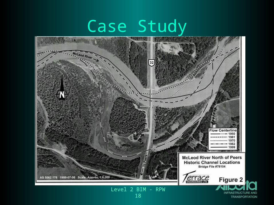
78104 McLeod River Peers M32 Contour Stream to Bottom of Footing = 2.1 m Protective measures requiredAngle of attack is 60° Consider apron and guidebanks
70247 McLeod River Edson Local Handrail Stream to Bottom of Footing = 1.2 m Conduct detailed survey
71429 Elbow River Bragg Creek M66 Handrail Top of Footing exposed Conduct detailed survey
74381 North Saskatchewan River Drayton Valley M22 Contour Severe scour at piers, spur River protection works being designed
74710 Berland River Entrance M40 Handrail Stream 0.75 m below pile cap Protection measures required

Level 2 BIM - RPW16
Case Study
BF78104
McLeod River near Peers
Hwy 32

Level 2 BIM - RPW17
Case Study
Level 2 BIM - RPW18
Case Study

Level 2 BIM - RPW19
Case Study

Level 2 BIM - RPW20
Case Study

Level 2 BIM - RPW21
Case Study

Level 2 BIM - RPW22
Case Study

Level 2 BIM - RPW23
Case Study

Level 2 BIM - RPW24
Case Study

Level 2 BIM - RPW25
Case Study

Level 2 BIM - RPW26
Case Study

Level 2 BIM - RPW27
Case Study

Level 2 BIM - RPW28
Case Study

Level 2 BIM - RPW29
Case Study