Lesson Summary Teaching Time Materials -...
13
Lesson Summary Students will start with a “pop quiz” about Antarctica and fill in a map of locations and features. Then the students will compare and contrast the arctic with the Antarctic and their home state. Prior Knowledge & Skills • Map skills • Knowledge of the Polar Regions AAAS Science Benchmarks The Mathematical World (with expand/adapt/connect #2) Reasoning NSES Science Standards History and Nature of Science Science as a Human Endeavor NCGE Geography Standards The World in Spatial Terms Standard 1 Places and Regions Standard 4 Standard 5 Physical Systems Standard 8 Teaching Time: ~ 1.5 hours Materials • Paper to cover a 4 x 4 ft. bulletin board • Overhead projector • Transparency of the Antarctic continent made from Blackline Master #2 (supplied) • Markers, crayons, pens • Atlases, encyclopedias, CD-ROMs, access to on-line research sources • Individual outline maps of Antarctica for students made from Blackline Master #2 Advanced Planning Preparation Time: ~10 minutes 1. Review the instructions 2. Gather the necessary supplies. Recommended Reading: (attached) • Teacher Background NASA Quest: An Educational Website http://quest.arc.nasa.gov/antarctica2/main/t_guide/activity_A1.html
Transcript of Lesson Summary Teaching Time Materials -...
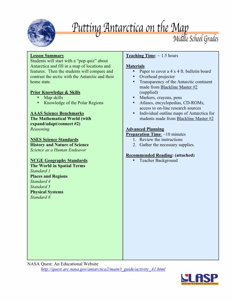
Lesson Summary Students will start with a “pop quiz” about Antarctica and fill in a map of locations and features. Then the students will compare and contrast the arctic with the Antarctic and their home state. Prior Knowledge & Skills
• Map skills • Knowledge of the Polar Regions
AAAS Science Benchmarks The Mathematical World (with expand/adapt/connect #2) Reasoning NSES Science Standards History and Nature of Science Science as a Human Endeavor NCGE Geography Standards The World in Spatial Terms Standard 1 Places and Regions Standard 4 Standard 5 Physical Systems Standard 8
Teaching Time: ~ 1.5 hours Materials
• Paper to cover a 4 x 4 ft. bulletin board • Overhead projector • Transparency of the Antarctic continent
made from Blackline Master #2 (supplied)
• Markers, crayons, pens • Atlases, encyclopedias, CD-ROMs,
access to on-line research sources • Individual outline maps of Antarctica for
students made from Blackline Master #2
Advanced Planning Preparation Time: ~10 minutes
1. Review the instructions 2. Gather the necessary supplies.
Recommended Reading: (attached)
• Teacher Background
NASA Quest: An Educational Website http://quest.arc.nasa.gov/antarctica2/main/t_guide/activity_A1.html
:: NASA Quest > Archives ::
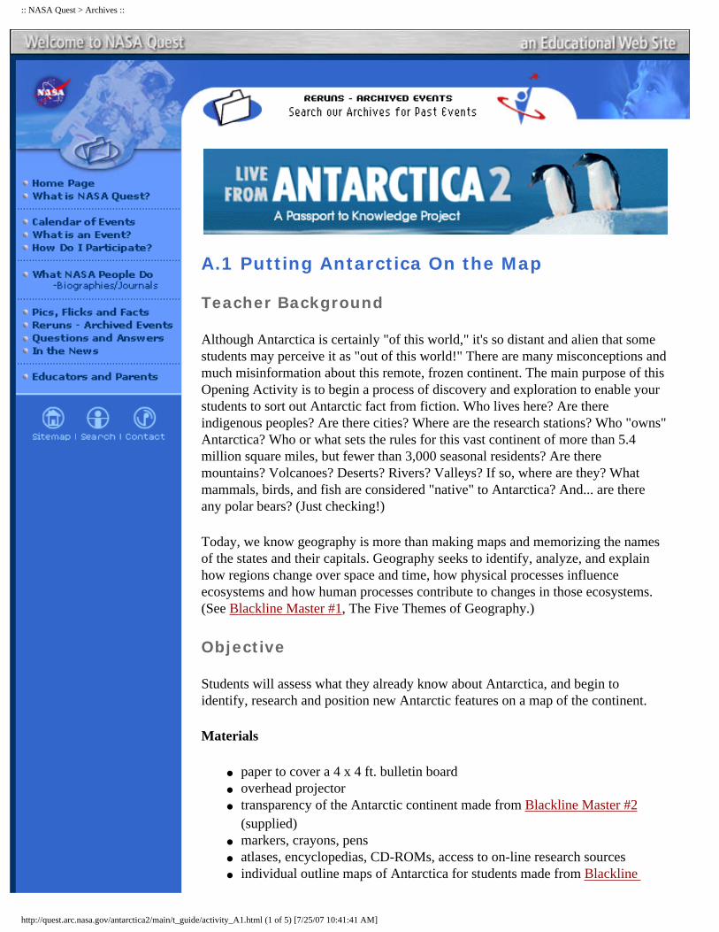
A.1 Putting Antarctica On the Map
Teacher Background
Although Antarctica is certainly "of this world," it's so distant and alien that some students may perceive it as "out of this world!" There are many misconceptions and much misinformation about this remote, frozen continent. The main purpose of this Opening Activity is to begin a process of discovery and exploration to enable your students to sort out Antarctic fact from fiction. Who lives here? Are there indigenous peoples? Are there cities? Where are the research stations? Who "owns" Antarctica? Who or what sets the rules for this vast continent of more than 5.4 million square miles, but fewer than 3,000 seasonal residents? Are there mountains? Volcanoes? Deserts? Rivers? Valleys? If so, where are they? What mammals, birds, and fish are considered "native" to Antarctica? And... are there any polar bears? (Just checking!)
Today, we know geography is more than making maps and memorizing the names of the states and their capitals. Geography seeks to identify, analyze, and explain how regions change over space and time, how physical processes influence ecosystems and how human processes contribute to changes in those ecosystems. (See Blackline Master #1, The Five Themes of Geography.)
Objective
Students will assess what they already know about Antarctica, and begin to identify, research and position new Antarctic features on a map of the continent.
Materials
�● paper to cover a 4 x 4 ft. bulletin board �● overhead projector �● transparency of the Antarctic continent made from Blackline Master #2
(supplied) �● markers, crayons, pens �● atlases, encyclopedias, CD-ROMs, access to on-line research sources �● individual outline maps of Antarctica for students made from Blackline
http://quest.arc.nasa.gov/antarctica2/main/t_guide/activity_A1.html (1 of 5) [7/25/07 10:41:41 AM]

:: NASA Quest > Archives ::
Master #2
Engage
Ask students to brainstorm about Antarctica. Here's a ten item "pop quiz" to test their knowledge of this vast (as large as North America and Mexico combined) and mysterious (visited to date by fewer humans than would fill a sports stadium!) continent. Have them write a true or false answer to each statement as you read it aloud:
1. Antarctica is the largest continent. (F) 2. There are cities in Antarctica. (T: McMurdo in summer swells to over 1,500
people) 3. You will find polar bears in Antarctica. (F) 4. Antarctica doubles in size and shrinks each year. True or False, and Why?
(T: The ice sheet grows and melts from winter to summer.) 5. Antarctica is a continent covered by ice and snow, just like the Arctic.
(T: for Antarctica. F: for the Arctic, which is ice over water, and is not a continent)
6. Daylight lasts for six months at the South Pole. (T) 7. There are rivers and volcanoes in Antarctica. (T) 8. There is water under nearly all the ice. (F) 9. Penguins live only in Antarctica. (F: Penguins live elsewhere south of the
equator, including coasts of South America, Southern Africa, and islands north of Antarctica.)
10. Antarctica is a territory of the United States. (F)
Check the test and ask students if their scores are "keepers" or if they would prefer a re-test at a later date. Ask students to file the quiz in their Antarctic Logbooks for later reference. Re-administer the pop quiz at the end of Live From Antarctica 2 and let students compare their results.
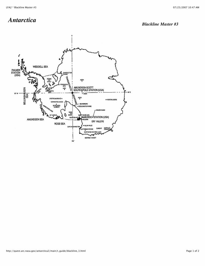
Note: the NSF booklet Facts About the USAP and the CTW/NSF Antarctica brochure co-packaged with this Guide contain geographic information which can be used with this Activity. NSF's Facts... is also on-line at the LFA 2 site. Blackline Master #3 is a simplified map with a limited number of place names. The LFA 2 Kit also includes an oversize USGS map packed with data.
Explore
Discuss whether it's a frustrating to miss answers to straightforward questions. Explain that participating in Live From Antarctica 2 can keep this from happening a second time. Encourage them in the coming weeks to see how many geographical features-physical, political, human, animal, economic, cultural and others-they can locate to boost their "A.K.Q." ("Antarctic Knowledge Quotient").
Procedure
1. Make a map transparency of Antarctica from Blackline Master #2. Project it onto a 4' x 4' piece of paper and trace the outline of the continent. Place it where it can
http://quest.arc.nasa.gov/antarctica2/main/t_guide/activity_A1.html (2 of 5) [7/25/07 10:41:41 AM]
:: NASA Quest > Archives ::
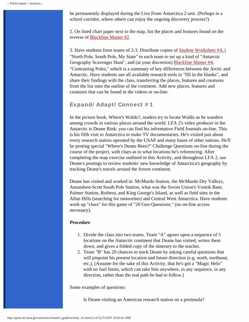
be permanently displayed during the Live From Antarctica 2 unit. (Perhaps in a school corridor, where others can enjoy the ongoing discovery process?)
2. On lined chart paper next to the map, list the places and features found on the reverse of Blackline Master #2.
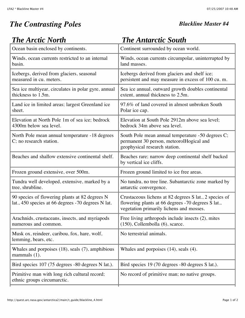
3. Have students form teams of 2-3. Distribute copies of Student Worksheet #A.1 "North Pole, South Pole, My State" to each team to set up a kind of "Antarctic Geography Scavenger Hunt", and (at your discretion) Blackline Master #4, "Contrasting Poles," which is a summary of key differences between the Arctic and Antarctic. Have students use all available research tools to "fill in the blanks", and share their findings with the class, transferring the places, features and creatures from the list onto the outline of the continent. Add new places, features and creatures that can be found in the videos or on-line.
Expand/Adapt/Connect #1
In the picture book, Where's Waldo?, readers try to locate Waldo as he wanders among crowds in various places around the world. LFA 2's video producer in the Antarctic is Deane Rink: you can find his informative Field Journals on-line. This is his fifth visit to Antarctica to make TV documentaries. He's visited just about every research station operated by the USAP and many bases of other nations. He'll be posting special "Where's Deane Been?" Challenge Questions on-line during the course of the project, with clues as to what locations he's referencing. After completing the map exercise outlined in this Activity, and throughout LFA 2, use Deane's postings to review students' new knowledge of Antarctica's geography by tracking Deane's travels around the frozen continent.
Deane has visited and worked in: McMurdo Station, the McMurdo Dry Valleys, Amundsen-Scott South Pole Station, what was the Soviet Union's Vostok Base, Palmer Station, Rothera, and King George's Island, as well as field sites in the Allan Hills (searching for meteorites) and Central West Antarctica. Have students work up "clues" for this game of "20 Geo-Questions." (no on-line access necessary).
Procedure
1. Divide the class into two teams. Team "A" agrees upon a sequence of 5 locations on the Antarctic continent that Deane has visited, writes them down, and gives a folded copy of the itinerary to the teacher.
2. Team "B" has 20 chances to track Deane by asking careful questions that will pinpoint his present location and future direction (e.g. north, northeast, etc.). (Assume for the sake of this Activity, that he's got a "Magic Helo" with no fuel limits, which can take him anywhere, in any sequence, in any direction, rather than the real path he had to follow.)
Some examples of questions:
Is Deane visiting an American research station on a peninsula?
http://quest.arc.nasa.gov/antarctica2/main/t_guide/activity_A1.html (3 of 5) [7/25/07 10:41:41 AM]

:: NASA Quest > Archives ::
Is Deane eating Thanksgiving dinner near Lake Hoare? (read his Field Journals in LFA 1)
Is Deane visiting the most populated settlement on the continent?
Expand/Adapt/Connect #2
Once students have enough new knowledge to feel confident, they can give the pop quiz to parents or younger students and then play Where's Deane Been? as a mentoring/learning experience.
Have students search for Antarctic maps on the Internet. (Check the LFA 2 Home Page as a place to start.) Have teams research and report to the whole class on the use of space-age technology (satellites, etc.) to create maps of Antarctica, the seasonal sea-ice surrounding it, the ozone hole, even the life-forms which live in the oceans. How does this technology work to create maps that track climate? Wildlife populations?
Using maps of Antarctica, have students work in teams to take measurements:
�● Palmer Station to McMurdo Station �● Punta Arenas, Chile to Palmer Station �● Palmer Station to Los Angeles
Have some go on-line and read Deane's Field Journals to see his actual travel path to the Antarctic in 1996-97 (LA, Aukland [NZ], Christchurch, McMurdo, South Pole, McMurdo, Christchurch, LA, Miami, Santiago [Chile], "P.A.", Palmer!)
Using the map's scale, convert measurements to miles and/or kilometers. Record distances on the class chart and compare. How do you account for the variations? (Maps with smaller scales lead to bigger errors.) What's the range of error?
Most scientific research uses the metric system, e.g. NSF's Facts... packaged with this Guide. Review metric measurement for temperature (Celsius rather than Fahrenheit) and distance (kilometers rather than miles). Have students practice using appropriate conversion formulas (see Glossary for C/F formulas) and post a temperature chart illustrating Celsius/ Fahrenheit temperatures.
http://quest.arc.nasa.gov/antarctica2/main/t_guide/activity_A1.html (4 of 5) [7/25/07 10:41:41 AM]
:: NASA Quest > Archives ::
Last Update: 1/18/97 Comments on the LFA Web site:
Webspinner.
©1996 Passport to Knowledge. All Rights Reserved.
http://quest.arc.nasa.gov/antarctica2/main/t_guide/activity_A1.html (5 of 5) [7/25/07 10:41:41 AM]
07/25/2007 10:46 AMLFA2 * Blackline Master #1
Page 1 of 2http://quest.arc.nasa.gov/antarctica2/main/t_guide/blackline_1.html
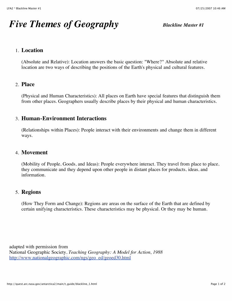
Five Themes of Geography Blackline Master #1
1. Location
(Absolute and Relative): Location answers the basic question: "Where?" Absolute and relativelocation are two ways of describing the positions of the Earth's physical and cultural features.
2. Place
(Physical and Human Characteristics): All places on Earth have special features that distinguish themfrom other places. Geographers usually describe places by their physical and human characteristics.
3. Human-Environment Interactions
(Relationships within Places): People interact with their environments and change them in differentways.
4. Movement
(Mobility of People, Goods, and Ideas): People everywhere interact. They travel from place to place,they communicate and they depend upon other people in distant places for products, ideas, andinformation.
5. Regions
(How They Form and Change): Regions are areas on the surface of the Earth that are defined bycertain unifying characteristics. These characteristics may be physical. Or they may be human.
adapted with permission from National Geographic Society, Teaching Geography: A Model for Action, 1988http://www.nationalgeographic.com/ngs/geo_ed/geoed30.html
07/25/2007 10:47 AMLFA2 * Blackline Master #2
Page 1 of 2http://quest.arc.nasa.gov/antarctica2/main/t_guide/blackline_2.html
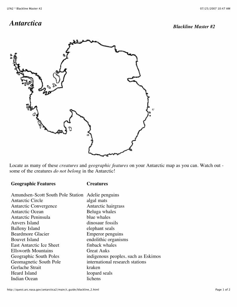
Antarctica Blackline Master #2
Locate as many of these creatures and geographic features on your Antarctic map as you can. Watch out -some of the creatures do not belong in the Antarctic!
Geographic Features
Amundsen-Scott South Pole StationAntarctic CircleAntarctic ConvergenceAntarctic OceanAntarctic PeninsulaAnvers IslandBalleny IslandBeardmore GlacierBouvet IslandEast Antarctic Ice SheetEllsworth MountainsGeographic South PolesGeomagnetic South PoleGerlache StraitHeard IslandIndian Ocean
Creatures
Adelie penguinsalgal matsAntarctic hairgrassBeluga whalesblue whalesdinosaur fossilselephant sealsEmperor penguinsendolithic organismsfinback whalesGreat Auksindigenous peoples, such as Eskimosinternational research stationskrakenleopard sealslichens

07/25/2007 10:47 AMLFA2 * Blackline Master #2
Page 2 of 2http://quest.arc.nasa.gov/antarctica2/main/t_guide/blackline_2.html
King George IslandMagnetic South PoleMarie Byrd LandMcMurdo Dry ValleysMcMurdo StationMount ErebusPalmer StationRonne-Filchner Ice ShelfRoss Ice ShelfRoss IslandRotheraScott BaseSentinel RangeSouth Atlantic IslandSouth Georgia IslandSouth Orkney IslandSouth Pacific OceanSouth Sandwich IslandSouth Shetland IslandsTransantarctic MountainsVostokVictoria Land Weddell Sea Vinson Massif
Macaroni penguinsostrichespearlwortpolar bearssei whalesskuasUSAP field teamsUSAP research stationswalrusesWeddell seals
07/25/2007 10:47 AMLFA2 * Blackline Master #3
Page 1 of 2http://quest.arc.nasa.gov/antarctica2/main/t_guide/blackline_3.html
AntarcticaBlackline Master #3
07/25/2007 10:48 AMLive from Antarctica 2 * Teacher's Guide
Page 1 of 2http://quest.arc.nasa.gov/antarctica2/main/t_guide/sw_A1.html
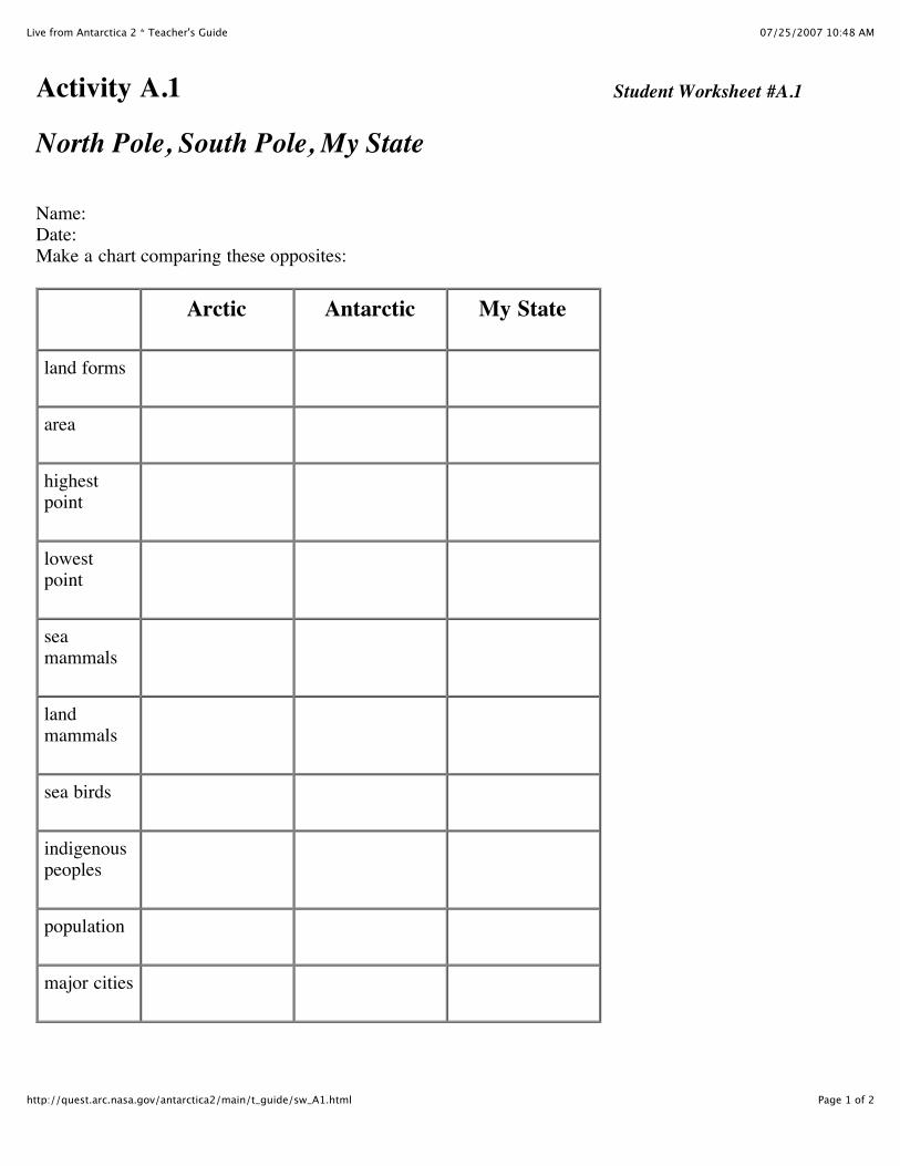
Activity A.1 Student Worksheet #A.1
North Pole, South Pole, My State
Name:Date:Make a chart comparing these opposites:
Arctic Antarctic My State
land forms
area
highestpoint
lowestpoint
seamammals
landmammals
sea birds
indigenouspeoples
population
major cities
07/25/2007 10:48 AMLFA2 * Blackline Master #4
Page 1 of 2http://quest.arc.nasa.gov/antarctica2/main/t_guide/blackline_4.html
The Contrasting Poles Blackline Master #4 The Arctic North Ocean basin enclosed by continents.
Winds, ocean currents restricted to an internalbasin.
Icebergs, derived from glaciers, seasonalmeasured in cu. meters.
Sea ice multiyear, circulates in polar gyre, annualthickness to 1.5m.
Land ice in limited areas; largest Greenland icesheet.
Elevation at North Pole 1m of sea ice; bedrock4300m below sea level.
North Pole mean annual temperature -18 degreesC; no research station.
Beaches and shallow extensive continental shelf.
Frozen ground extensive, over 500m.
Tundra well developed, extensive, marked by atree, shrubline.
90 species of flowering plants at 82 degrees Nlat., 450 species at 66 degrees -70 degrees N lat.
Arachnids, crustaceans, insects, and myriapodsnumerous and common.
Musk ox, reindeer, caribou, fox, hare, wolf,lemming, bears, etc.
Whales and porpoises (18), seals (7), amphibiousmammals (1).
Bird species 107 (75 degrees -80 degrees N lat.).
Primitive man with long rich cultural record;ethnic groups circumarctic.
The Antarctic South Continent surrounded by ocean world.
Winds, ocean currents circumpolar, uninterrupted byland masses.
Icebergs derived from glaciers and shelf ice;persistent and may measure in excess of 100 cu. m.
Sea ice annual, outward growth doubles continentalextent, annual thickness to 2.5m.
97.6% of land covered in almost unbroken SouthPolar ice cap.
Elevation at South Pole 2912m above sea level;bedrock 34m above sea level.
South Pole mean annual temperature -50 degrees C;permanent 30 person, meteorolHogical andgeophysical research station.
Beaches rare; narrow deep continental shelf backedby vertical ice cliffs.
Frozen ground limited to ice free areas.
No tundra, no tree line. Subantarctic zone marked byantarctic convergence.
Crustaceous lichens at 82 degrees S lat., 2 species offlowering plants at 66 degrees -70 degrees S lat.,vegetation primarily lichens and mosses.
Free living arthropods include insects (2), mites(150), Collembolla (6), scarce.
No terrestrial animals.
Whales and porpoises (14), seals (4).
Bird species 19 (70 degrees -80 degrees S lat.).
No record of primitive man; no native groups.
�
07/25/2007 10:48 AMLFA2 * Blackline Master #4
Page 2 of 2http://quest.arc.nasa.gov/antarctica2/main/t_guide/blackline_4.html
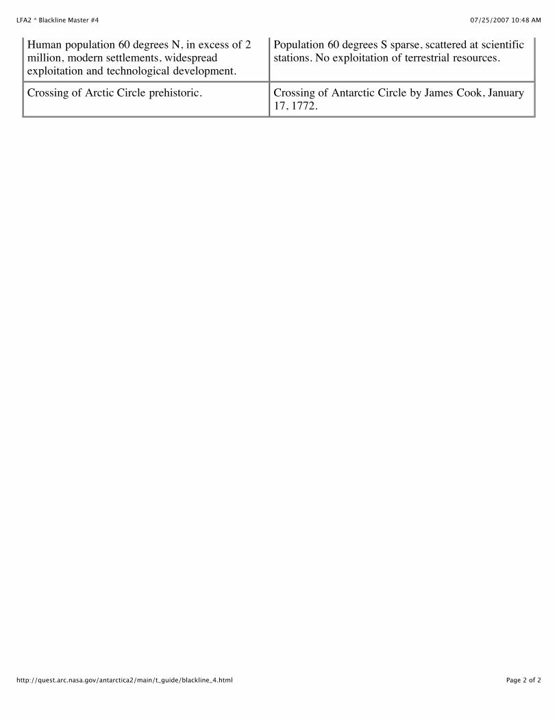
Human population 60 degrees N, in excess of 2million, modern settlements, widespreadexploitation and technological development.
Crossing of Arctic Circle prehistoric.
Population 60 degrees S sparse, scattered at scientificstations. No exploitation of terrestrial resources.
Crossing of Antarctic Circle by James Cook, January17, 1772.