Leica TPS1200 Series - Geotech Bratislava · Leica TPS1200 Series High performance Total Station...
12
Leica TPS1200 Series High performance Total Station
Transcript of Leica TPS1200 Series - Geotech Bratislava · Leica TPS1200 Series High performance Total Station...
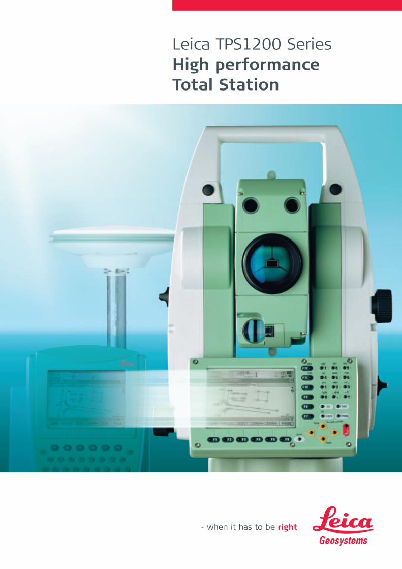
Leica TPS1200 SeriesHigh performance Total Station
Leica_TPS_1200_en_v07.qxd 21.11.2006 8:44 Uhr Seite 1
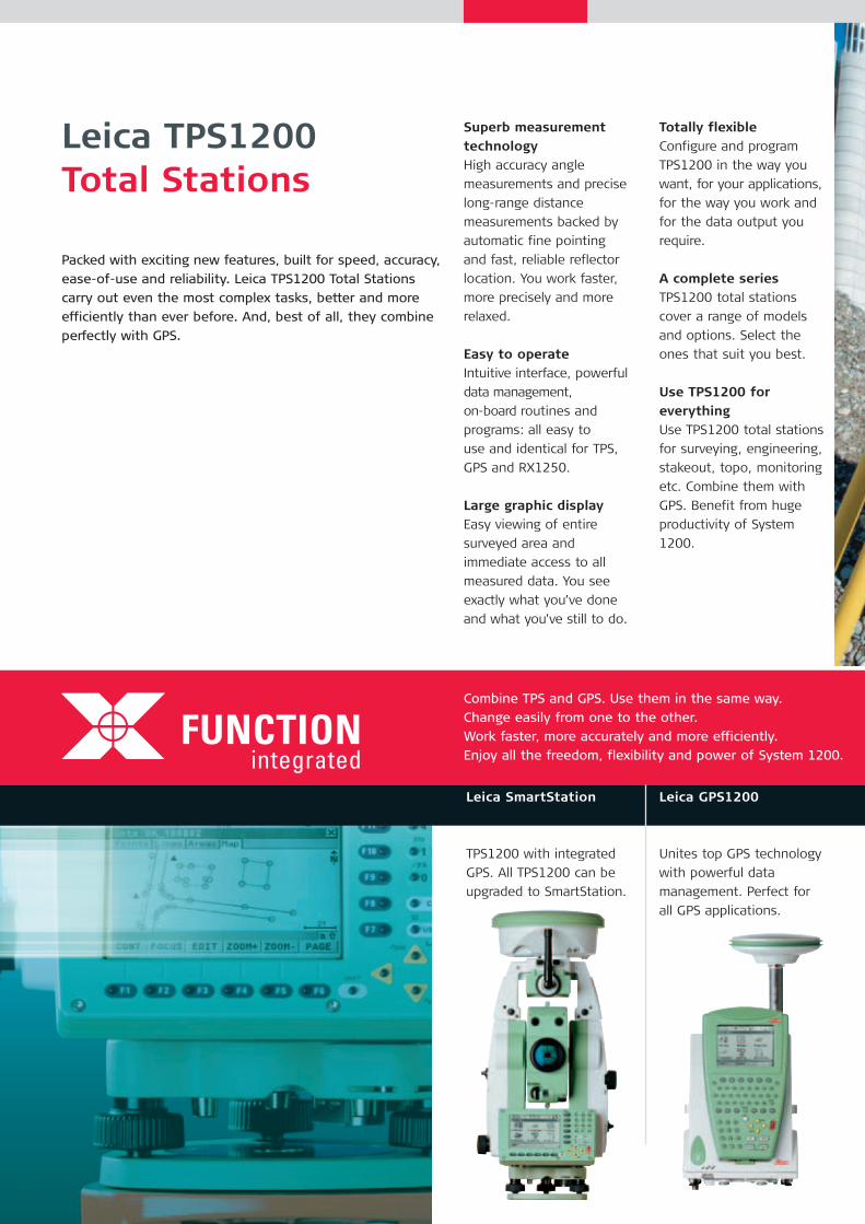
Leica TPS1200 Total Stations
Packed with exciting new features, built for speed, accuracy,
ease-of-use and reliability. Leica TPS1200 Total Stations
carry out even the most complex tasks, better and more
efficiently than ever before. And, best of all, they combine
perfectly with GPS.
FUNCTIONintegrated
Combine TPS and GPS. Use them in the same way.
Change easily from one to the other.
Work faster, more accurately and more efficiently.
Enjoy all the freedom, flexibility and power of System 1200.
Leica GPS1200
Unites top GPS technology
with powerful data
management. Perfect for
all GPS applications.
Leica SmartStation
TPS1200 with integrated
GPS. All TPS1200 can be
upgraded to SmartStation.
Superb measurementtechnologyHigh accuracy angle
measurements and precise
long-range distance
measurements backed by
automatic fine pointing
and fast, reliable reflector
location. You work faster,
more precisely and more
relaxed.
Easy to operateIntuitive interface, powerful
data management,
on-board routines and
programs: all easy to
use and identical for TPS,
GPS and RX1250.
Large graphic displayEasy viewing of entire
surveyed area and
immediate access to all
measured data. You see
exactly what you’ve done
and what you’ve still to do.
Totally flexibleConfigure and program
TPS1200 in the way you
want, for your applications,
for the way you work and
for the data output you
require.
A complete seriesTPS1200 total stations
cover a range of models
and options. Select the
ones that suit you best.
Use TPS1200 for everythingUse TPS1200 total stations
for surveying, engineering,
stakeout, topo, monitoring
etc. Combine them with
GPS. Benefit from huge
productivity of System
1200.
Leica_TPS_1200_en_v07.qxd 21.11.2006 8:45 Uhr Seite 2

Leica System 1200
TPS and GPS
Working together
For all applications
Today and in the future
Designed and built to
the most stringent
standards with the latest
measurement technologies,
Leica System 1200
instruments are extremely
efficient and reliable, and
stand up to the severest
environments.
A new, highly intuitive
user interface, a multitude
of functions and features,
powerful data management,
and user-programming
capabilities are common
to both System 1200 TPS
and GPS instruments.
Operators can switch
instantly between TPS and
GPS and use whichever is
the most convenient and
suitable; extra training is
not required.
These new high-tech TPS
and GPS instruments with
identical operation enable
you to do every type of
job, faster, more accurately
and more efficiently than
ever before.
And most important,
you reduce your costs and
increase your profits.
00.
Leica Geo Office
Everything you need in a
single package for TPS and
GPS: import, visualization,
conversions, quality control,
processing, adjustment,
reporting, export etc.
Leica TPS1200
Top performance, high
accuracy total stations
do everything you want
and much more.
Leica SmartWorx
SmartWorx TPS/GPS
application software is
both easy-to-use and
extremely powerful.
Leica SmartPole
Save time with SmartPoles’
setup On-the-fly and
easily swap between GPS
and TPS when needed.
Leica_TPS_1200_en_v07.qxd 21.11.2006 8:45 Uhr Seite 3
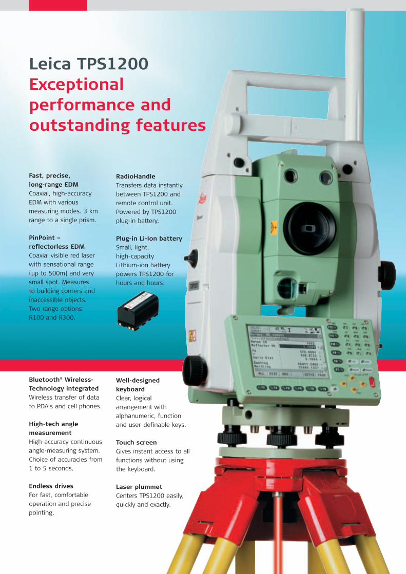
Leica TPS1200Exceptional performance and outstanding features
Fast, precise, long-range EDMCoaxial, high-accuracy
EDM with various
measuring modes. 3 km
range to a single prism.
PinPoint – reflectorless EDMCoaxial visible red laser
with sensational range
(up to 500m) and very
small spot. Measures
to building corners and
inaccessible objects.
Two range options:
R100 and R300.
Bluetooth® Wireless-Technology integratedWireless transfer of data
to PDA’s and cell phones.
High-tech angle measurementHigh-accuracy continuous
angle-measuring system.
Choice of accuracies from
1 to 5 seconds.
Endless drivesFor fast, comfortable
operation and precise
pointing.
RadioHandleTransfers data instantly
between TPS1200 and
remote control unit.
Powered by TPS1200
plug-in battery.
Plug-in Li-Ion batterySmall, light,
high-capacity
Lithium-ion battery
powers TPS1200 for
hours and hours.
Well-designed keyboardClear, logical
arrangement with
alphanumeric, function
and user-definable keys.
Touch screenGives instant access to all
functions without using
the keyboard.
Laser plummetCenters TPS1200 easily,
quickly and exactly.
Leica_TPS_1200_en_v07.qxd 21.11.2006 8:45 Uhr Seite 4
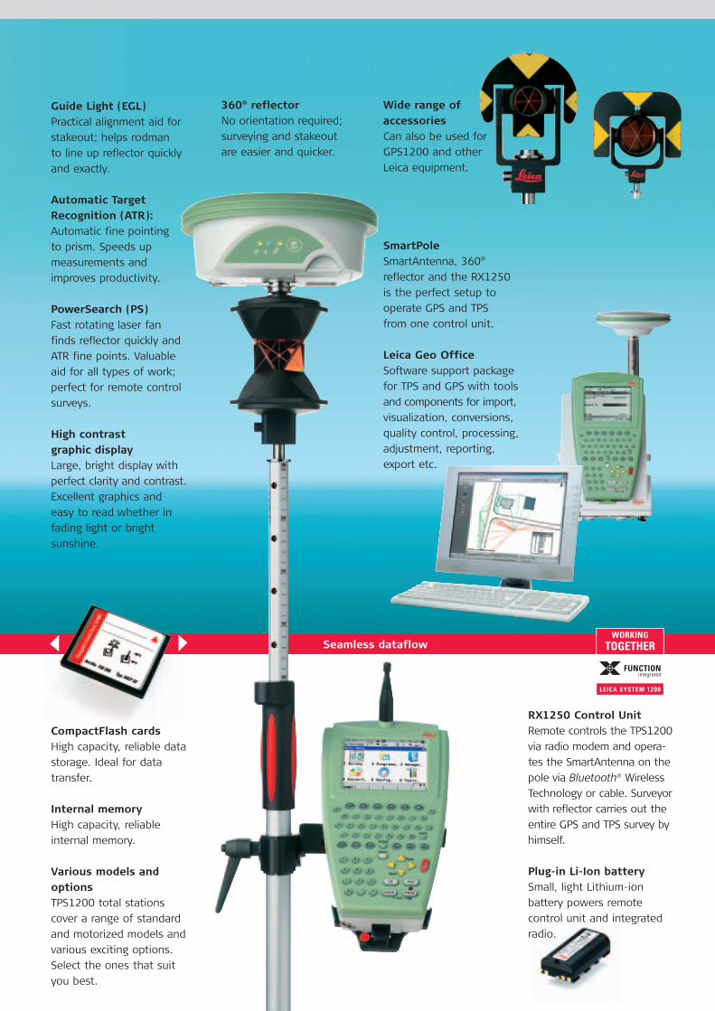
RX1250 Control UnitRemote controls the TPS1200
via radio modem and opera-
tes the SmartAntenna on the
pole via Bluetooth® Wireless
Technology or cable. Surveyor
with reflector carries out the
entire GPS and TPS survey by
himself.
Plug-in Li-Ion batterySmall, light Lithium-ion
battery powers remote
control unit and integrated
radio.
360° reflector No orientation required;
surveying and stakeout
are easier and quicker.
Wide range of accessoriesCan also be used for
GPS1200 and other
Leica equipment.
SmartPoleSmartAntenna, 360°
reflector and the RX1250
is the perfect setup to
operate GPS and TPS
from one control unit.
Leica Geo OfficeSoftware support package
for TPS and GPS with tools
and components for import,
visualization, conversions,
quality control, processing,
adjustment, reporting,
export etc.
Seamless dataflow
Guide Light (EGL)Practical alignment aid for
stakeout; helps rodman
to line up reflector quickly
and exactly.
Automatic TargetRecognition (ATR):Automatic fine pointing
to prism. Speeds up
measurements and
improves productivity.
PowerSearch (PS)Fast rotating laser fan
finds reflector quickly and
ATR fine points. Valuable
aid for all types of work;
perfect for remote control
surveys.
High contrast graphic display Large, bright display with
perfect clarity and contrast.
Excellent graphics and
easy to read whether in
fading light or bright
sunshine.
CompactFlash cardsHigh capacity, reliable data
storage. Ideal for data
transfer.
Internal memoryHigh capacity, reliable
internal memory.
Various models andoptionsTPS1200 total stations
cover a range of standard
and motorized models and
various exciting options.
Select the ones that suit
you best.
Leica_TPS_1200_en_v07.qxd 21.11.2006 8:45 Uhr Seite 5
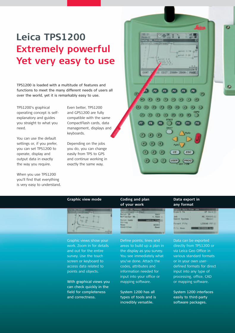
Coding and plan of your work
Define points, lines and
areas to build up a plan in
the display as you survey.
You see immediately what
you’ve done. Attach the
codes, attributes and
information needed for
input into your office or
mapping software.
System 1200 has all
types of tools and is
incredibly versatile.
Graphic view mode
Graphic views show your
work. Zoom in for details
and out for the entire
survey. Use the touch
screen or keyboard to
access data related to
points and objects.
With graphical views you
can check quickly in the
field for completeness
and correctness.
Data export in any format
Data can be exported
directly from TPS1200 or
via Leica Geo Office in
various standard formats
or in your own user-
defined formats for direct
input into any type of
processing, office, CAD
or mapping software.
System 1200 interfaces
easily to third-party
software packages.
Leica TPS1200Extremely powerfulYet very easy to use
TPS1200 is loaded with a multitude of features and
functions to meet the many different needs of users all
over the world, yet it is remarkably easy to use.
TPS1200’s graphical
operating concept is self-
explanatory and guides
you straight to what you
need.
You can use the default
settings or, if you prefer,
you can set TPS1200 to
operate, display and
output data in exactly
the way you require.
When you use TPS1200
you’ll find that everything
is very easy to understand.
Even better, TPS1200
and GPS1200 are fully
compatible with the same
CompactFlash cards, data
management, displays and
keyboards.
Depending on the jobs
you do, you can change
easily from TPS to GPS
and continue working in
exactly the same way.
Leica_TPS_1200_en_v07.qxd 21.11.2006 8:45 Uhr Seite 6
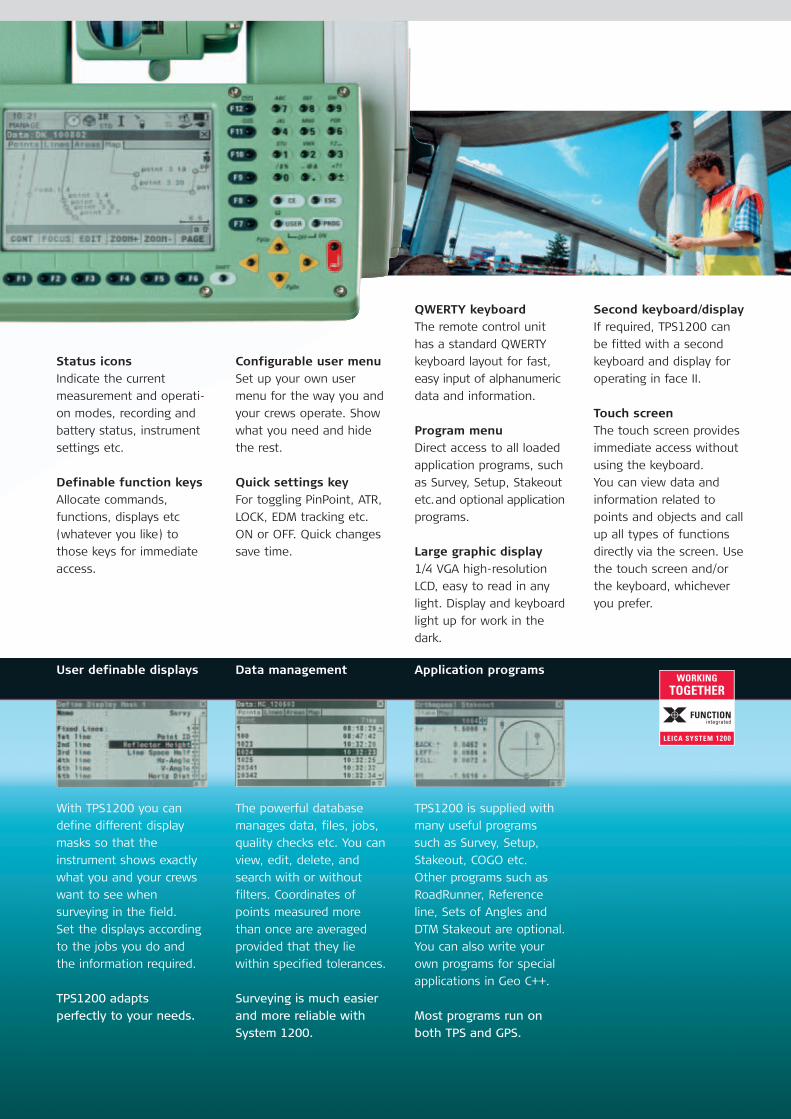
User definable displays
With TPS1200 you can
define different display
masks so that the
instrument shows exactly
what you and your crews
want to see when
surveying in the field.
Set the displays according
to the jobs you do and
the information required.
TPS1200 adapts
perfectly to your needs.
Data management
The powerful database
manages data, files, jobs,
quality checks etc. You can
view, edit, delete, and
search with or without
filters. Coordinates of
points measured more
than once are averaged
provided that they lie
within specified tolerances.
Surveying is much easier
and more reliable with
System 1200.
Application programs
TPS1200 is supplied with
many useful programs
such as Survey, Setup,
Stakeout, COGO etc.
Other programs such as
RoadRunner, Reference
line, Sets of Angles and
DTM Stakeout are optional.
You can also write your
own programs for special
applications in Geo C++.
Most programs run on
both TPS and GPS.
Second keyboard/displayIf required, TPS1200 can
be fitted with a second
keyboard and display for
operating in face II.
Touch screenThe touch screen provides
immediate access without
using the keyboard.
You can view data and
information related to
points and objects and call
up all types of functions
directly via the screen. Use
the touch screen and/or
the keyboard, whichever
you prefer.
Status iconsIndicate the current
measurement and operati-
on modes, recording and
battery status, instrument
settings etc.
Definable function keysAllocate commands,
functions, displays etc
(whatever you like) to
those keys for immediate
access.
QWERTY keyboardThe remote control unit
has a standard QWERTY
keyboard layout for fast,
easy input of alphanumeric
data and information.
Program menuDirect access to all loaded
application programs, such
as Survey, Setup, Stakeout
etc. and optional application
programs.
Large graphic display1/4 VGA high-resolution
LCD, easy to read in any
light. Display and keyboard
light up for work in the
dark.
Configurable user menuSet up your own user
menu for the way you and
your crews operate. Show
what you need and hide
the rest.
Quick settings keyFor toggling PinPoint, ATR,
LOCK, EDM tracking etc.
ON or OFF. Quick changes
save time.
Leica_TPS_1200_en_v07.qxd 21.11.2006 8:45 Uhr Seite 7

Leica TPS1200High-precision measurement technologyTime-saving measurement aids
PinPoint –reflectorless EDM (RL)
Marks the point preciselyMeasures directlyPinPoint is the ideal tool for
measuring to wall corners,
inaccessible objects,
facades, rock faces, roofs
and walls inside buildings,
in fact to anything at which
it is difficult to set up a
reflector.
PinPoint’s tightly bundled
laser marks the point
exactly with a small red dot.
Measurements are taken
instantly and directly
(no complex routines
measurement).
And with PinPoint you can
also take very long distance
measurements to prisms.
� Optional for all TPS1200
� Two versions: standard
range R100 (up to
200 m), superior range
R300 (up to 500 m)
� Very small laser spot,
marks the point exactly
� Standard measurement
and tracking modes
� Accuracy 3 mm + 2 ppm
� Motorized TPS1200
with PinPoint – the
perfect tool for scanning
facades
Automatic TargetRecognition (ART / LOCK)
Measure points quick and accurateWith ATR, you only need
to point roughly and take
a measurement; TPS1200
then fine points to the
center of the prism and
measures, all fully auto-
matically. In LOCK mode
TPS1200 remains locked
onto the reflector and
follows it as it moves.
Measurements can be
taken at any time. And, as
software predicts reflector
movements, TPS1200
continues to track in
spite of obstructions and
short interruptions. If long
interruptions should cause
complete loss of lock,
use PowerSearch.
� Optional for motorized
TPS1200
� Eliminates manual
operation
� Very fast
measurements
� Uniform high accuracy
� Works with standard
prisms (no need for
active target)
Angle and distance measurement (IR)
Highest accuracyLongest rangeTPS1200’s precision
angle-measurement system
operates continuously
providing instant horizontal
and vertical circle readings
that are automatically
corrected for any “out of
level” by a centrally located
twin-axis compensator.
The coaxial EDM uses an
infrared laser, has various
measuring modes, and
measures to prisms and
reflective tape.
The range is excellent –
3 km to a single prism –
and the accuracy superb –
2 mm + 2 ppm. Resolution
is 0.1 mm.
� Fast, continuous,
high-accuracy angle
measurements
� Choice of accuracy
from 1 to 5 seconds
� No initialization
� Twin-axis compensator
� EDM with standard,
fast and tracking modes
� Long range,
fast measurements
and high accuracy
� Totally reliable
Leica_TPS_1200_en_v07.qxd 21.11.2006 8:45 Uhr Seite 8

Remote Control Unit (RX1250)
Operate at the reflector
With the RX1250 remote
control unit you can con-
trol both the TPS1200 via
RadioModem and Radio-
Handle and the GPS Smart-
Antenna via Bluetooth®
Wireless Technology or
cable from the reflector
pole. The control unit has
the same display as the
TPS1200, a touch screen,
optionally a colourscreen
and a full alphanumeric
QWERTY keyboard.
Operation is exactly the
same. You can trigger mea-
surements, enter codes,
use routines and programs,
collect data from GPS and
TPS – whatever you like.
� Optional for all TPS1200
� Extend setup to
SmartPole
� Best with ATR,
PowerSearch and
360° reflector
� Light, rugged, reliable
� Reliable wireless com-
munication via Radio-
Handle and Bluetooth®
Wireless Technology
� Perfect one-man
survey system
� No need for cables
� Increases efficiency
and productivity
PowerSearch(PS)
Finds reflector automaticallyPowerSearch finds reflectors
within seconds no matter
where they are. With Power-
Search activated, TPS1200
rotates and sends out a
vertical laser fan. As soon
as the fan strikes a prism
TPS1200 stops rotating, ATR
takes over and fine points
– all fully automatically.
Use PowerSearch for the
first ATR measurement or to
find the reflector again if
Automatic Target Tracking
loses lock completely.
PowerSearch is particularly
advantageous when opera-
ting with remote control.
� Optional for motorized
TPS1200 equipped
with ATR
� Activated at the
touch of a key or auto-
matically, if configured
� Finds standard prisms
(no need for active
target)
� Saves time, increases
productivity
� Highly recommended
for fast, efficient
remote control
SmartStation(ATX1230)
TPS & GPS perfectly combinedTPS1200 with GPS Smart-
Antenna combined in one
compact, easy-to-use
instrument. No need for
control points, traverses or
resections. Set up Smart-
Station and let RTK GPS
determine the position
within seconds to centi-
meter accuracy, then
survey and stake out with
TPS1200.
The total station controls
all measurements, displays
and data, for both GPS
and TPS. Once SmartStation
is positioned, use the
SmartAntenna on a pole
with controller and sensor
as an RTK rover.
� TPS and GPS combined
into one instrument
� Fix the position
with RTK then survey
with TPS
� No need for control
points, traverses or
resections
� Increase productivity
and profits
� All TPS1200 can
be upgraded to
SmartStation
Work easily, quickly and comfortablyIncrease productivity and profits
Leica_TPS_1200_en_v07.qxd 21.11.2006 8:45 Uhr Seite 9
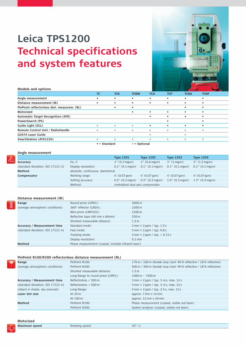
Leica TPS1200Technical specifications and system features
Models and optionsTC TCR TCRM TCA TCP TCRA TCRP
Angle measurement • • • • • • •
Distance measurement (IR) • • • • • • •
PinPoint reflectorless dist. measurem. (RL) • • • •
Motorized • • • • •
Automatic Target Recognition (ATR) • • • •
PowerSearch (PS) • •
Guide Light (EGL) ° ° ° • • • •
Remote Control Unit / RadioHandle ° ° ° ° ° ° °GUS74 Laser Guide ° °SmartStation (ATX1230) ° ° ° ° ° ° °
• = Standard ° = Optional
Angle measurementType 1201 Type 1202 Type 1203 Type 1205
Accuracy Hz, V 1’’ (0.3 mgon) 2’’ (0.6 mgon) 3’’ (1 mgon) 5’’ (1.5 mgon)
(standard deviation, ISO 17123-3) Display resolution: 0.1’’ (0.1 mgon) 0.1’’ (0.1 mgon) 0.1’’ (0.1 mgon) 0.1’’ (0.1 mgon)
Method absolute, continuous, diametrical
Compensator Working range: 4’ (0.07 gon) 4’ (0.07 gon) 4’ (0.07 gon) 4’ (0.07 gon)
Setting accuracy: 0.5’’ (0.2 mgon) 0.5’’ (0.2 mgon) 1.0’’ (0.3 mgon) 1.5’’ (0.5 mgon)
Method: centralized dual axis compensator
Distance measurement (IR)Range Round prism (GPR1): 3000 m
(average atmospheric conditions) 360° reflector (GRZ4): 1500 m
Mini prism (GMP101): 1200 m
Reflective tape (60 mm x 60mm) 250 m
Shortest measurable distance: 1.5 m
Accuracy / Measurement time Standard mode: 2 mm + 2 ppm / typ. 1.5 s
(standard deviation, ISO 17123-4) Fast mode: 5 mm + 2 ppm / typ. 0.8 s
Tracking mode: 5 mm + 2 ppm / typ. < 0.15 s
Display resolution: 0.1 mm
Method Phase measurement (coaxial, invisible infrared laser)
PinPoint R100/R300 reflectorless distance measurement (RL)Range PinPoint R100: 170 m / 100 m (Kodak Gray Card: 90 % reflective / 18 % reflective)
(average atmospheric conditions) PinPoint R300: 500 m / 300 m (Kodak Gray Card: 90 % reflective / 18 % reflective)
Shortest measurable distance: 1.5 m
Long Range to round prism (GPR1): 1000 m – 7500 m
Accuracy / Measurement time Reflectorless < 500 m: 3 mm + 2 ppm / typ. 3-6 s, max. 12 s
(standard deviation, ISO 17123-4) Reflectorless > 500 m: 5 mm + 2 ppm / typ. 3-6 s, max. 12 s
(object in shade, sky overcast) Long Range: 5 mm + 2 ppm / typ. 2.5 s, max. 12 s
Laser dot size At 20 m: approx. 7 mm x 14 mm
At 100 m: approx. 12 mm x 40 mm
Method PinPoint R100: Phase measurement (coaxial, visible red laser)
PinPoint R300: System analyzer (coaxial, visible red laser)
MotorizedMaximum speed Rotating speed: 45° / s
Leica_TPS_1200_en_v07.qxd 21.11.2006 8:45 Uhr Seite 10
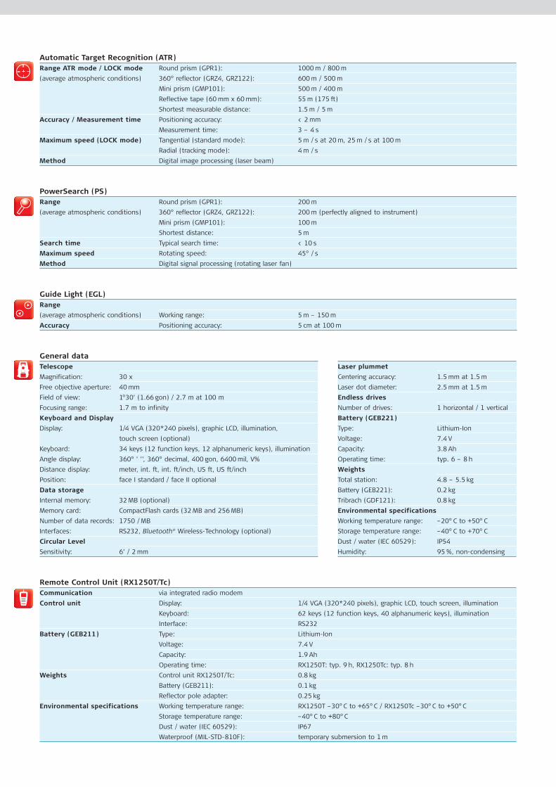
Automatic Target Recognition (ATR)Range ATR mode / LOCK mode Round prism (GPR1): 1000 m / 800 m
(average atmospheric conditions) 360° reflector (GRZ4, GRZ122): 600 m / 500 m
Mini prism (GMP101): 500 m / 400 m
Reflective tape (60 mm x 60 mm): 55 m (175 ft)
Shortest measurable distance: 1.5 m / 5 m
Accuracy / Measurement time Positioning accuracy: < 2 mm
Measurement time: 3 – 4 s
Maximum speed (LOCK mode) Tangential (standard mode): 5 m / s at 20 m, 25 m / s at 100 m
Radial (tracking mode): 4 m / s
Method Digital image processing (laser beam)
PowerSearch (PS)Range Round prism (GPR1): 200 m
(average atmospheric conditions) 360° reflector (GRZ4, GRZ122): 200 m (perfectly aligned to instrument)
Mini prism (GMP101): 100 m
Shortest distance: 5 m
Search time Typical search time: < 10 s
Maximum speed Rotating speed: 45° / s
Method Digital signal processing (rotating laser fan)
Guide Light (EGL)Range
(average atmospheric conditions) Working range: 5 m – 150 m
Accuracy Positioning accuracy: 5 cm at 100 m
General dataTelescope Laser plummet
Magnification: 30 x Centering accuracy: 1.5 mm at 1.5 m
Free objective aperture: 40 mm Laser dot diameter: 2.5 mm at 1.5 m
Field of view: 1°30’ (1.66 gon) / 2.7 m at 100 m Endless drives
Focusing range: 1.7 m to infinity Number of drives: 1 horizontal / 1 vertical
Keyboard and Display Battery (GEB221)
Display: 1/4 VGA (320*240 pixels), graphic LCD, illumination, Type: Lithium-Ion
touch screen (optional) Voltage: 7.4 V
Keyboard: 34 keys (12 function keys, 12 alphanumeric keys), illumination Capacity: 3.8 Ah
Angle display: 360° ’ ’’, 360° decimal, 400 gon, 6400 mil, V% Operating time: typ. 6 – 8 h
Distance display: meter, int. ft, int. ft/inch, US ft, US ft/inch Weights
Position: face I standard / face II optional Total station: 4.8 – 5.5 kg
Data storage Battery (GEB221): 0.2 kg
Internal memory: 32 MB (optional) Tribrach (GDF121): 0.8 kg
Memory card: CompactFlash cards (32 MB and 256 MB) Environmental specifications
Number of data records: 1750 / MB Working temperature range: –20° C to +50° C
Interfaces: RS232, Bluetooth® Wireless-Technology (optional) Storage temperature range: –40° C to +70° C
Circular Level Dust / water (IEC 60529): IP54
Sensitivity: 6’ / 2 mm Humidity: 95 %, non-condensing
Remote Control Unit (RX1250T/Tc)Communication via integrated radio modem
Control unit Display: 1/4 VGA (320*240 pixels), graphic LCD, touch screen, illumination
Keyboard: 62 keys (12 function keys, 40 alphanumeric keys), illumination
Interface: RS232
Battery (GEB211) Type: Lithium-Ion
Voltage: 7.4 V
Capacity: 1.9 Ah
Operating time: RX1250T: typ. 9 h, RX1250Tc: typ. 8 h
Weights Control unit RX1250T/Tc: 0.8 kg
Battery (GEB211): 0.1 kg
Reflector pole adapter: 0.25 kg
Environmental specifications Working temperature range: RX1250T –30°C to +65°C / RX1250Tc –30°C to +50°C
Storage temperature range: –40°C to +80°C
Dust / water (IEC 60529): IP67
Waterproof (MIL-STD-810F): temporary submersion to 1 m
Leica_TPS_1200_en_v07.qxd 21.11.2006 8:45 Uhr Seite 11
Lorem ipsumdolor sit.Adipisicing elit,sed do eiusmodtempor incididuntut labore et.
Illustrations, descriptions and technical specifications are not binding and may change. Printed in Switzerland – Copyright Leica Geosystems AG, Heerbrugg, Switzerland, 2006. 738582en – XI.06 – RDV
Leica Geosystems AGSwitzerland
www.leica-geosystems.com
Leica GRX1200Product brochure
LeicaSmartStationProduct brochure
Leica SmartPoleProduct brochure
Leica GPS1200Product brochure
Leica System 1200SoftwareProduct brochure
Total Quality Management – our commitment to total customer satisfaction.
Ask your local Leica Geosystems dealer for more informationabout our TQM program.
Distance meter (PinPoint R100 / R300):Laser class 3R in accordance with IEC 60825-1 resp. EN 60825-1
Laser plummet:Laser class 2 in accordance with IEC 60825-1 resp. EN 60825-1
Distance meter (IR), ATR and PowerSearch:Laser class 1 in accordance with IEC 60825-1 resp. EN 60825-1
Guide light (EGL):LED class 1 in accordance with IEC 60825-1 resp. EN 60825-1
The Bluetooth® word mark and logosare owned by Bluetooth SIG, Inc. andany use of such marks by LeicaGeosystems AG is under license. Othertrademarks and trade names arethose of their respective owners.
Whether you want to survey a parcel of land or a construction site, a
facade or indoors to create as-built plans or carry out high-precision
measurements of bridge and tunnel constructions – Leica Geosystems’
surveying instruments provide the right solution for all measuring tasks.
The System 1200 Series instruments as well as the software are designed
to meet the daily challenges of modern surveying. They all have
outstanding, easy to read and user-friendly interfaces. Their straight-
forward menu structures, their clearly outlined scope of functions and
high technology perfectly mate GPS and TPS applications in the field.
Whether you use the advantages of both technologies combined or each
separately – due to the exceptional flexibility of Leica Geosystems
instruments, reliable and productive surveying is assured.
When it has to be right.
Leica_TPS_1200_en_v07.qxd 21.11.2006 8:45 Uhr Seite 12