Legend - Amazon Web Services...Legend Building Corral Dam Dugout Gate Graveyard Power Pump Spring...
10
Sources: Esri, HERE, DeLorme, Intermap, increment P Corp., GEBCO, USGS, FAO, NPS, NRCAN, GeoBase, IGN, Kadaster NL, Ordnance Survey, Esri Japan, METI, Esri China (Hong Kong), swisstopo, MapmyIndia, © OpenStreetMap contributors, and the GIS User Community Projection: UTM Zone 13 Datum: NAD83 0 0.2 0.4 0.6 0.8 0.1 Kilometers Legend Building Corral Dam Dugout Gate Graveyard Power Pump Spring Trough Well Windmill Fence Trail Waterline Field Hay Plots Pasture Boundary - SPP Di scl a im er : Information within this map is provided as a public service by the Government of Saskatchewan and is provided strictly "as is" and without warranty of any kind, either expressed or implied. We cannot guarantee that all information is current or accurate. Every effort is made to ensure the accuracy, currency and reliability of the content. However, at any time, some details may not yet reflect recent changes. Users should verify information before acting on it. Neither the Minister nor the Government accepts any responsibility for any losses or damages arising from anyone using this information. CAUTION: This map may be generalized and may not reflect current conditions. It is not designed to assist in navigation or as a substitute for legal survey. The coordinates displayed do not represent legal parcel corners and/or boundaries and they cannot be used for establishment of or in lieu of legal land survey boundaries, for property or parcels thereof. 1:18,056 Scale E 18-07-33-1 Date: February 15, 2017 μ
Transcript of Legend - Amazon Web Services...Legend Building Corral Dam Dugout Gate Graveyard Power Pump Spring...

Sources: Esri, HERE, DeLorme, Intermap, increment P Corp., GEBCO, USGS,FAO, NPS, NRCAN, GeoBase, IGN, Kadaster NL, Ordnance Survey, Esri Japan,METI, Esri China (Hong Kong), swisstopo, MapmyIndia, © OpenStreetMapcontributors, and the GIS User Community
Projection: UTM Zone 13 Datum: NAD83
0 0.2 0.4 0.6 0.80.1
Kilometers
Legend
Building
Corral
Dam
Dugout
Gate
Graveyard
Power
Pump
Spring
Trough
Well
Windmill
Fence
Trail
Waterline
Field
Hay Plots
Pasture Boundary - SPP
Discla im er :In formation with in this m ap is provided as a public service by theGov er nm ent o f Saskatchewan and is provided strictly "as is" and withoutwarranty of any kind, e ither ex pr es sed or im plied. We cannot guaranteethat a l l inform ation is current or accurate. E very effor t is made to ens ur ethe ac curacy, currency and re liabi li ty o f the c ontent. However, at any tim e,some deta ils may not y et re flec t rec ent changes. Us ers should v erifyin form ation befor e acting on i t. Neither the Minister nor the Governmentac cepts any respons ib il ity for any loss es or damages ar ising from anyoneus ing th is in for mation.CA UTION: This map may be genera l ized and may not r eflec t c ur rentconditions . It is not designed to assist in nav igation or as a subs titu te forlegal s urvey. The coor dinates d is play ed do not r epresent legal parc elcorners and/or boundaries and they cannot be used for establ is hm ent o for in l ieu of legal land s urvey boundar ies, for proper ty or parc els thereof.
1:18,056Scale
E 18-07-33-1
Date: February 15, 2017
μ


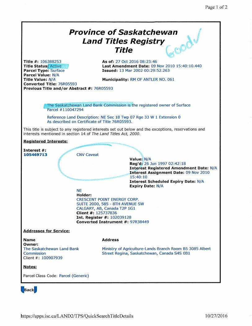
Page 1 of 2Property Report Print Date: 16-Dec-2016
Municipality Name:
Civic Address:
Legal Location:
Supplementary:
ANTLER (RM)
Qtr NE Sec 18 Tp 07 Rg 33 W 1 Sup
Assessment ID Number: 061-000418100 PID: 1513514
School Division: 209 Inspected Date:
Change Reason:
Year / Frozen ID:
Call Back Year:
04-Sep-2002
2016/-47
Method_in_use: C.A.M.A. - Cost
Property Use: Arable Land
Predom Code:
Puse Code: Arable Land
Title Acres: 160.000
Neighborhood: 200
''
Taxable ExemptClass
TaxLiability
VAof value Tax Status
Percentage
Subdivision
Assessed & Taxable/Exempt Values (Summary)
Assessed ValuesDescription
55% TaxableOther AgriculturalAgricultural 68,500 1 37,675
37,67568,500Total of Assessed Values Total of Taxable/Exempt Values:
Acres Productivity Determining Factors Rating
AGRICULTURAL ARABLE LAND
Land Use Economic and Physical Factors
34.72FIELD CROP PRODUCTN
WS - [WHITESAND]
SL - [SANDY LOAM]
T1: Level to nearly level
S4: Strong
30 339.21Soil assocation 1
Soil texture 1
Topography
Stones (qualities)
$/ACRE
Final
K - [CULTIVATED]
Soil texture 2 LS - [LOAMY SAND]
Soil profile 1 OR10 - [CHERN-ORTH (CA 9-12)]
Natural hazard WSB: Waste Slough Bush Rate: 0.92
Soil assocation 2
Soil texture 3
Soil texture 4
Soil profile 2
WS - [WHITESAND]
SL - [SANDY LOAM]
LS - [LOAMY SAND]
CAL10 - [CHERN-CAL (CA 9-12)]
Top soil depth
4-6
4-6
© 2016 Saskatchewan Assessment Management Agency, All Rights Reserved. Data Source: Govern_Prod
Page 2 of 2RM OF 061 Assessment ID Number: 061-000418100 PID: 1513514 Print Date: 16-Dec-2016
59.42FIELD CROP PRODUCTN
OX - [OXBOW]
L - [LOAM]
T2: Gentle slopes
S2: Slight
100 580.52Soil assocation 1
Soil texture 1
Topography
Stones (qualities)
$/ACRE
Final
K - [CULTIVATED]
Soil profile 1 OR10 - [CHERN-ORTH (CA 9-12)]
Natural hazard WSB: Waste Slough Bush Rate: 0.92
Soil assocation 2
Soil texture 3
Soil texture 4
Soil profile 2
OX - [OXBOW]
L - [LOAM]
CAL10 - [CHERN-CAL (CA 9-12)]
Top soil depth
4-6
4-6
AGRICULTURAL WASTE LAND
Acres Land Use Waste Type
WETLANDS30 WASTE SLOUGH BUSH
© 2016 Saskatchewan Assessment Management Agency, All Rights Reserved. Data Source: Govern_Prod


Page 1 of 2Property Report Print Date: 16-Dec-2016
Municipality Name:
Civic Address:
Legal Location:
Supplementary:
ANTLER (RM)
Qtr SE Sec 18 Tp 07 Rg 33 W 1 Sup
Assessment ID Number: 061-000418300 PID: 1513498
School Division: 209 Inspected Date:
Change Reason:
Year / Frozen ID:
Call Back Year:
04-Sep-2002
2016/-47
Method_in_use: C.A.M.A. - Cost
Property Use: Arable Land
Predom Code:
Puse Code: Arable Land
Title Acres: 160.000
Neighborhood: 200
''
Taxable ExemptClass
TaxLiability
VAof value Tax Status
Percentage
Subdivision
Assessed & Taxable/Exempt Values (Summary)
Assessed ValuesDescription
55% TaxableOther AgriculturalAgricultural 57,400 1 31,570
31,57057,400Total of Assessed Values Total of Taxable/Exempt Values:
Acres Productivity Determining Factors Rating
AGRICULTURAL ARABLE LAND
Land Use Economic and Physical Factors
33.21FIELD CROP PRODUCTN
WS - [WHITESAND]
SL - [SANDY LOAM]
T1: Level to nearly level
S4: Strong
30 324.46Soil assocation 1
Soil texture 1
Topography
Stones (qualities)
$/ACRE
Final
K - [CULTIVATED]
Soil texture 2 LS - [LOAMY SAND]
Soil profile 1 OR10 - [CHERN-ORTH (CA 9-12)]
Natural hazard WSB: Waste Slough Bush Rate: 0.88
Soil assocation 2
Soil texture 3
Soil texture 4
Soil profile 2
WS - [WHITESAND]
SL - [SANDY LOAM]
LS - [LOAMY SAND]
CAL10 - [CHERN-CAL (CA 9-12)]
Top soil depth
4-6
4-6
© 2016 Saskatchewan Assessment Management Agency, All Rights Reserved. Data Source: Govern_Prod

Page 2 of 2RM OF 061 Assessment ID Number: 061-000418300 PID: 1513498 Print Date: 16-Dec-2016
56.84FIELD CROP PRODUCTN
OX - [OXBOW]
L - [LOAM]
T2: Gentle slopes
S2: Slight
85 555.28Soil assocation 1
Soil texture 1
Topography
Stones (qualities)
$/ACRE
Final
K - [CULTIVATED]
Soil profile 1 OR10 - [CHERN-ORTH (CA 9-12)]
Natural hazard WSB: Waste Slough Bush Rate: 0.88
Soil assocation 2
Soil texture 3
Soil texture 4
Soil profile 2
OX - [OXBOW]
L - [LOAM]
CAL10 - [CHERN-CAL (CA 9-12)]
Top soil depth
4-6
4-6
AGRICULTURAL WASTE LAND
Acres Land Use Waste Type
WETLANDS45 WASTE SLOUGH BUSH
© 2016 Saskatchewan Assessment Management Agency, All Rights Reserved. Data Source: Govern_Prod