LCP CHEMICALS SUPERFUND SITE - epa.gov › sites › production › files › 2015-04 › ... ·...
54
Page 1 of 50 U.S. ENVIRONMENTAL PROTECTION AGENCY SUPERFUND PROPOSED PLAN LCP CHEMICALS SUPERFUND SITE OPERABLE UNIT 1 City of Brunswick, Glynn County, Georgia November 2014 INTRODUCTION The U. S. Environmental Protection Agency (EPA) is issuing this Proposed Plan 1 (Plan) for the LCP Chemicals Superfund Site in the City of Brunswick, Glynn County, Georgia. This Proposed Plan is issued by the EPA, the lead agency for the Site, and the Georgia Environmental Protection Division (GAEPD), the support agency. The Plan presents the results of the remedial investigation/feasibility study (RI/FS), including baseline risk assessments (BRAs) for the marsh (Operable Unit [OU] 1) at the LCP Chemicals Site. In addition, this Plan includes summaries of the alternatives evaluated and provides the rationale for EPA’s selection of the preferred alternative. The preferred alternative presented in this Plan addresses the ecological and human health risks associated with contaminated sediments and surface water in OU1. EPA, in consultation with GAEPD, will select the final remedy for the Site after the public comment period has ended and the information submitted during the comment period has been reviewed and considered. Changes to the preferred alternative or selection of another alternative may occur if public comments or additional data support such modification. The final decision regarding the selected remedy will be documented in a Record of Decision (ROD). EPA is issuing this Plan as part of its public participation responsibilities under Section 117(a) of the Comprehensive Environmental Response, Compensation and Liability Act (CERCLA or Superfund). The Plan summarizes information that can be found in greater detail in the RI/FS reports and other documents, which present the results of sampling conducted from 1995 through 2012. These reports and documents are contained in the Administrative Record (AR) file, located at the Information Repository. 1 Terms first appearing in bold are defined in the glossary at the end of this Proposed Plan. PUBLIC COMMENT PERIOD: December 4, 2014 – February 2, 2015 U.S. EPA will accept written comments on the Proposed Plan during the public comment period. PUBLIC MEETING: As a part of the public involvement process, a public meeting is scheduled on December 4, 2014. The meeting will be held at the Brunswick-Glynn County Library, 208 Gloucester Street, Brunswick, GA 31520 at 6:00 pm. At this meeting, the EPA will present the information it has about the Site, describe its reasons for selecting the preferred alternative outlined in the Proposed Plan, and answer any questions. Oral and written comments will be accepted at the meeting. For more information, see the Administrative Record at the following locations: Brunswick-Glynn Co. Library U.S. EPA - Region 4 208 Gloucester Street Superfund Records Center Brunswick, GA 31520 61 Forsyth St., SW (912) 267-1212 Atlanta, GA 30303
Transcript of LCP CHEMICALS SUPERFUND SITE - epa.gov › sites › production › files › 2015-04 › ... ·...

Page 1 of 50
U.S. ENVIRONMENTAL PROTECTION AGENCY
SUPERFUND PROPOSED PLAN
LCP CHEMICALS SUPERFUND SITE
OPERABLE UNIT 1
City of Brunswick, Glynn County, Georgia November 2014
INTRODUCTION
The U. S. Environmental Protection Agency (EPA)
is issuing this Proposed Plan1 (Plan) for the LCP
Chemicals Superfund Site in the City of
Brunswick, Glynn County, Georgia. This
Proposed Plan is issued by the EPA, the lead agency
for the Site, and the Georgia Environmental
Protection Division (GAEPD), the support agency.
The Plan presents the results of the remedial
investigation/feasibility study (RI/FS), including
baseline risk assessments (BRAs) for the marsh
(Operable Unit [OU] 1) at the LCP Chemicals Site.
In addition, this Plan includes summaries of the
alternatives evaluated and provides the rationale for
EPA’s selection of the preferred alternative. The
preferred alternative presented in this Plan
addresses the ecological and human health risks
associated with contaminated sediments and
surface water in OU1.
EPA, in consultation with GAEPD, will select the
final remedy for the Site after the public comment
period has ended and the information submitted during the comment period has been reviewed and
considered. Changes to the preferred alternative or selection of another alternative may occur if public
comments or additional data support such modification. The final decision regarding the selected
remedy will be documented in a Record of Decision (ROD). EPA is issuing this Plan as part of its
public participation responsibilities under Section 117(a) of the Comprehensive Environmental
Response, Compensation and Liability Act (CERCLA or Superfund). The Plan summarizes
information that can be found in greater detail in the RI/FS reports and other documents, which present
the results of sampling conducted from 1995 through 2012. These reports and documents are contained
in the Administrative Record (AR) file, located at the Information Repository.
1 Terms first appearing in bold are defined in the glossary at the end of this Proposed Plan.
PUBLIC COMMENT PERIOD:
December 4, 2014 – February 2, 2015
U.S. EPA will accept written comments on the
Proposed Plan during the public comment period.
PUBLIC MEETING:
As a part of the public involvement process, a
public meeting is scheduled on December 4, 2014.
The meeting will be held at the Brunswick-Glynn
County Library, 208 Gloucester Street, Brunswick,
GA 31520 at 6:00 pm. At this meeting, the EPA
will present the information it has about the Site,
describe its reasons for selecting the preferred
alternative outlined in the Proposed Plan, and
answer any questions. Oral and written
comments will be accepted at the meeting.
For more information, see the Administrative Record
at the following locations:
Brunswick-Glynn Co. Library U.S. EPA - Region 4
208 Gloucester Street Superfund Records Center
Brunswick, GA 31520 61 Forsyth St., SW
(912) 267-1212 Atlanta, GA 30303

Page 2 of 50
1.0 SITE BACKGROUND
On June 17, 1996, the LCP Chemicals (Brunswick, GA) Site was added to the National Priorities List
(NPL). The NPL listing means that the Site ranks among the nation’s highest priorities among the
known releases of hazardous substances, pollutants or contaminants for remedial evaluation and
response under the federal Superfund law, CERCLA.
1.1 Site Description
Figure 1 illustrates the key features of the Site. The dominant physical feature of the Site is the 670+
acres of marsh, designated as OU1, that are located west of the formerly industrialized upland portion of
the Site (designated as OU3). The main feature of the LCP Chemicals marsh is Purvis Creek, which
divides the marshlands roughly in half - north to south. Purvis Creek flows into the Turtle River (See
Section 1.3 below).
Some of the major features of the upland area are shown on Figure 2.
1.2 Site History
The Atlantic Refining Company (ARCO) operated the Site as a petroleum refinery from 1918 to the
early 1930s. The refinery ceased operations by 1935. Georgia Power Company purchased portions of
the Site between 1937 and 1950, and operated electric power generating facilities. The Dixie Paint and
Varnish Company operated a paint and varnish manufacturing facility at the Site from 1946 to 1956.
In 1956, the Allied Chemical and Dye Corporation (now Honeywell) built and operated a chlor-alkali
facility at the Site, principally for the production of chlorine gas, hydrogen gas, and caustic solution.
The plant operated using the mercury cell process, which involves passing a concentrated brine
solution between stationary graphite anodes and a flowing mercury cathode to produce chlorine gas,
sodium hydroxide (caustic) solution, and hydrogen gas. Sodium hypochlorite (bleach) was also
produced in a secondary reaction. For a time, the graphite anodes were impregnated with the
polychlorinated biphenyl (PCB) Aroclor 1268 to extend their life.
LCP Chemicals of Georgia, Inc. purchased the property and chlor-alkali plant in 1979. Operations
continued until 1994, when LCP Chemicals implemented a shutdown of the plant. Releases of chemicals
from past process operations and disposal activities have resulted in contaminated marsh sediments and
upland areas as well as surface water bodies, which in turn has adversely impacted ecological receptors
including fish and other wildlife that inhabit the marsh area and/or forage in the surface water bodies
within OU1.
Enforcement Activities
In February 1994, after numerous investigations by the GAEPD and the EPA, GAEPD requested that
the EPA initiate removal enforcement actions at the Site. According to the Action Memorandum signed
in May 1994, the Site was a high priority for removal action.
A Unilateral Administrative Order was issued in 1994 and then amended in 1995, to add potentially
responsible parties (PRPs). Three PRPs; Allied, Georgia Power, and ARCO, subsequently entered into a
mixed funding Administrative Order on Consent (AOC) to conduct additional removal activities in
August 1997. The removal was completed in July 1999. The RI/FS has been performed pursuant to an

Page 3 of 50
AOC, between ARCO, Allied, Georgia Power and the EPA. The PRPs agreed to perform the RI/FS
concurrently with the removal work.
In May 2007, Honeywell, identified earlier as the successor to Allied, signed an AOC, agreeing to
perform a time-critical removal of a caustic brine pool located in the vicinity of the former mercury cell
buildings.
Public Participation
The EPA has developed an electronic reading room for the Site that contains the documents which will
support remedy selection and related information. The Site’s remedial project managers have met with
and made presentations before the members of the Glynn Environmental Coalition and participated in
radio interviews about the Site. The Region also publishes the quarterly Brunswick Environmental
Cleanup Newsletter to update the public on the cleanup progress at the LCP Chemicals Site and the
three other Superfund sites in the Brunswick area.
1.3 Setting and Hydrodynamics of the Marsh
The 670+ acre LCP Chemicals marsh is bordered to the west by Turtle River, to the north by Gibson
Creek (a tributary to the Turtle River) and to the south by the Brunswick Cellulose facility (Figure 1).
The intertidal vegetated marshes are a net depositional zone for suspended sediments due to the low
current velocities and presence of vegetation within those areas. “Net depositional” means that particles
are more likely to settle than to scour from the area.
Purvis Creek has a maximum depth of approximately 11 feet (ft) and a maximum width of 500 ft. The
Turtle River is tidally influenced, as are Purvis Creek and the other smaller channels and ditches in the
LCP Chemicals marsh, and is considered salt water in the vicinity of Brunswick and the LCP Chemicals
Site. The Turtle River water surface elevation can vary in excess of nine ft during a tidal cycle.
Many of the smaller channels in the LCP Chemicals marsh have been named in the course of the Site’s
numerous investigations, including the manmade LCP Ditch (a.k.a. Main Canal), Eastern Creek, Western
Creek Complex (WCC), Domain 3 Creek, and Dillon Duck (Figure 1). The physical separation of the
LCP Chemicals marsh by these drainage features led to the designation of “domains” which are
mostly wetland areas of similar physical setting and contamination characteristics, as shown on Figure 1.
The risk assessments evaluated exposure to contaminants in these domains and creek areas.
Domain 1 is 21 acres in size and bounded by the Uplands to the east, the Main Canal to the north and
Eastern Creek to the west. Because this Domain is located closest to LCP Chemical’s discharge /
disposal areas, a removal of contaminated sediments took place in the eastern portion of Domain 1 in
1998-1999. Domain 2 is 115 acres in size and is bounded on the east by Domain 1, the south by
Uplands and the west and north by Purvis Creek and the Main Canal. It contains the WCC. Domain 3
is 108 acres in size and is bounded to the south by the Main Canal, the east by the uplands which are
part of the Site, and the west and north by Purvis Creek. Domain 4 is 417 acres in size and is the area
west of Purvis Creek up to the Turtle River. Domain 4 is divided into an eastern and western portion
by the surface water flow divide between creek and river.

Page 4 of 50
Figure 1 – Features of the LCP Marsh

Page 5 of 50
Figure 2 – Features of the Upland Portion of the LCP Chemicals Site

Page 6 of 50
1.4 Land Use
The LCP Chemicals marsh is zoned by Glynn County as a conservation preservation (CP) district. The
intent of the CP designation is to preserve and/or control development areas of the County which: 1)
serve as wildlife refuges, 2) possess natural beauty or are of historical significance, 3) are utilized for
outdoor recreational purposes, 4) provide needed open spaces for the health and general welfare of the
county inhabitants, or 5) are subject to period flooding.
Purvis Creek and associated streams within OU1 are considered Coastal and Marine Estuarine Waters
and under the Georgia Water Use Classifications at O.G.C.A. Chapter 391-3-6-.03(14) include the
following use Classifications: Recreation, Fishing, Propagation of Fish, Shellfish, Game and Other
Aquatic Life and Coastal Fishing.
1.5 Past Actions
As mentioned above, in 1998-1999, there was a removal and proper disposal of 142,000 cubic yards
(CY) of waste and contaminated soil from the Uplands, and 25,000 CY from the marsh sediments
closest to the sources of historical facility discharge. The approximately 13 acres of highly
contaminated marsh sediments were excavated, backfilled with clean fill, and re-vegetated with native
marsh grasses. Dredging of primary source sediment was also performed along a portion of Eastern
Creek and in select portions of the LCP Ditch (2,650 linear ft). These actions were conducted by the
PRP group as Superfund removal actions and resulted in the removal of 39,000 tons of principal threat
waste located in the marsh area. As a result of these removal actions, the remaining contamination in
OU1 is considered to be low-level threat waste to be addressed by this Superfund remedial action.
2.0 SITE CHARACTERISTICS
The PRP Group conducted an extensive RI from 1994 to 2012 to determine the nature and extent of
contamination in OU1 and assess the risks to human health and the environment posed by the
contamination. More than 4,700 sediment samples were analyzed for contaminants, including heavy
metals, volatile organic compounds (VOCs), semi-volatile organic compounds (SVOCs) and
PCBs. A Baseline Human Health Risk Assessment (HHRA) and Baseline Ecological Risk Assessment
(BERA) were completed as part of the RI process. These risk assessments are discussed in the
Summary of Site Risks section of this Proposed Plan. The RI, Baseline HHRA and BERA were
approved by the EPA and GAEPD and are available for review at the LCP Chemicals Electronic
Reading Room, on the worldwide web at www.epa.gov/Region04/LCP Chemical Reading Room.
As a result of the RI studies and risk assessments, a limited number of contaminants were identified as
contaminants of concern (COCs) that warranted further evaluation and remedial action under
CERCLA..
2.1 Distribution of COCs in Sediment
The compilation of pre- and post-removal action sampling events provides a comprehensive data set for
the understanding of the COC distributions in the marsh. Figures 3 through 6 show the COC
concentrations in surface sediment samples, defined as samples with a starting depth at the sediment
surface and collected from the interval of 0-to-6 inches, or 0-to-1 ft below the sediment surface; the
0-to-1 ft interval was used when upper 6-inch intervals were unavailable.

Page 7 of 50
Mercury: The highest mercury concentrations, typically in the range of 10 milligrams per kilogram
(mg/kg) to 100 mg/kg, are found in Eastern Creek, most notably in the southern half of the channel
where the previous dredging was limited (due to the more restricted channel width and depth, as well as
the meandering nature of the channel) and further south beyond the limits of where the dredging
occurred in the removal action. In contrast, the average sediment mercury concentration in the
reference stations was 0.09 mg/kg.
Two reference locations were used during the various ecological studies. One (Troup Creek) was
located about 4.3 miles from the marsh, on the eastern side of the Brunswick Peninsula, and the other
west of Sapelo Island, over 25 miles from the Brunswick area. The purpose of these reference
locations is to collect data from areas presumed to have been uncontaminated with the LCP Chemicals
Site, for the sake of comparison.
As shown in Figure 3, elevated mercury concentrations also occur in the LCP Ditch, most notably in the
region where Eastern Creek joins this feature, with concentrations typically in the range of 5 mg/kg to 25
mg/kg. A third area with elevated mercury concentrations is in the western segment of the WCC, where
mercury concentrations are generally highest in the “headwater” portion of this channel, ranging from 5
mg/kg to 25 mg/kg. With the exception of the areas proximal to the Uplands in Domain 1 as delineated
above, in the marsh flats and tidal channels beyond these regions, including Purvis Creek, sediment
mercury levels are typically at concentrations of less than 2-5 mg/kg, and lower yet in the marsh west of
the tidal node which divides Domain 4 into “a” and “b” portions (Figure 1).
Methylmercury (MeHg) was measured at over 150 sediment sampling locations throughout OU1. The
MeHg in sediment ranged from below detection limits to 0.05 mg/kg, with a mean concentration of
0.005 mg/kg. Only a small fraction of the mercury in sediment was present as MeHg. Because MeHg
readily bioaccumulates, it is more prevalent and toxic in biota tissue and toxic than elemental mercury.
What is Mercury?
One of the main contaminants in the LCP Chemicals marsh is mercury. Allied Chemical and LCP Chemicals used
mercury in the production of chlorine and caustic soda at the mercury-cell chlor-alkali plants.
Most of the mercury in surface water, sediments, and plants in the marsh is in the form of inorganic mercury salts; whereas
organic forms of mercury (e.g., methylmercury) are dominant in shellfish, fish and wildlife. Methylation of mercury is
a key step in the entrance of mercury into food chains. The biotransformation of inorganic mercury to methylated organic
forms can occur in the sediment and the water column. Mercury is known to adversely affect aquatic organisms through
inhibition of reproduction, reduction in growth rate, increased frequency of tissue histopathology, impairment in ability
to capture prey and olfactory receptor function, alterations in blood chemistry and enzyme activities, disruption of thyroid
function, and other metabolic and biochemical functions. It is emphasized that methylmercury is significantly more toxic
and bioaccumulative than inorganic mercury.
Mercury biomagnifies up the food chain. The accumulation of methylmercury by aquatic biota is rapid and depuration
is slow relative to inorganic mercury, which is less efficiently adsorbed and more readily eliminated from the body.
Hence, methylmercury is significantly more toxic and bioaccumulative than inorganic mercury. Nearly all of the mercury
that accumulates in fish is methylmercury. Accordingly, mercury exposure and accumulation is of particular concern for
animals at the highest trophic levels in the aquatic food webs and for animals and humans that feed on these organisms.
Mercury is a known human and ecological toxicant. Methylmercury-induced neurotoxicity is the effect of greatest
concern when exposure occurs to the developing fetus. Dietary methylmercury is almost completely absorbed into the
blood and distributed to all tissues including the brain; it also readily passes through the placenta to the fetus and fetal
brain. Neurotoxic effects include subtle decrements in motor skills and sensory ability at comparatively low doses. Other
adverse effects of mercury include reduced reproductive success, impaired growth and development, and behavioral
abnormalities.

Page 8 of 50
Figure 3 – Mercury Concentrations in LCP Marsh Sediments
• Ov...-12~g
• 8 - 12 mg.icg
• • - 8 mg/l<g
• 2 - 4~g
• 1 - 2mglkg
0 - 1~g
OeMc.• I Creeklets

Page 9 of 50
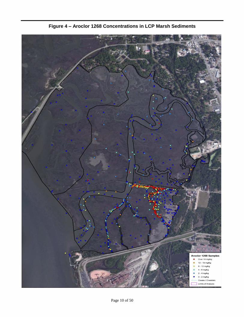
Aroclor1268: Sediment concentrations of Aroclor 1268 (the predominant PCB mixture in the LCP
marsh) exhibit a spatial pattern generally consistent with that of mercury, with the highest sediment
concentrations observed in the LCP Ditch and Eastern Creek (Figure 4). The Aroclor 1268
concentrations are noticeably higher compared to mercury at these locations, with many more sample
locations in the range of 25 mg/kg to 100 mg/kg or higher. Aroclor 1268 concentrations also tend to be
a bit higher compared with mercury in Purvis Creek, in particular in the central portion of Purvis Creek
where Aroclor 1268 is in the range of 5 mg/kg to 10 mg/kg. Similar to mercury, the Aroclor 1268
concentrations are lowest in the marsh west of Purvis Creek. Aroclor 1268 was not detected above
0.06 mg/kg in the reference stations.
Lead: Sample locations with the more elevated concentrations of lead occur in the Dillon Duck feature,
the upper headwaters of Domain 3 Creek (located in the northern portion of the Site), and the former
Glynn County landfill (Figure 5). Concentrations are typically in excess of 100 mg/kg in these locations,
whereas elsewhere the concentrations are consistently in the range of 10 mg/kg to 50 mg/kg.
PAHs: The contaminant distribution for total polycyclic aromatic hydrocarbons (P AHs) is
consistent with other COCs previously described (Figure 6), with the more elevated conditions present
in the tidal channel areas. The majority of the marsh flats (i.e., vegetated top of marsh) in the LCP
Chemicals marsh are low to non-detect for PAHs.
What are the Contaminants of Concern (COCs) in the LCP Chemicals Marsh?
The term “COC” is used in human health and ecological risk assessments to identify those chemicals that may be harmful
to human health and the environment. The COCs in the LCP Chemicals marsh include mercury (addressed above), PCBs,
lead and polycyclic aromatic hydrocarbons (PAHs).
Polychlorinated Biphenyls. PCBs are mixtures of up to 209 different compounds (referred to as “congeners”) that include
a biphenyl and from one to ten chlorine atoms. They have been used commercially since 1930 as dielectric and heat-
exchange fluids and in a variety of other applications. While PCBs were manufactured and sold under many names, the
most common were the Aroclor series. The most commonly detected Aroclor mixture in the LCP marsh is Aroclor 1268.
This mixture contains approximately 68% chlorine by mass. PCBs (largely Aroclor 1268) were used at and released to the
environment from the LCP Chemicals facility. They are persistent and accumulate in food webs. PCBs bioaccumulate in
the fatty tissues of humans and other animals. PCBs are considered probable human carcinogens and are linked to other
adverse health effects, such as developmental effects, reduced birth weights, and reduced ability to fight infection. Aroclor
1268 is also persistent and does not readily degrade in the environment.
Lead. Lead is not a human health concern in the LCP Chemicals marsh; however, it is a COC that can affect benthic
organisms. This heavy metal was released to the marsh from the LCP Chemicals facility. Lead is generally toxic to aquatic
organisms, especially in ionic form. Long-term exposure to lead may result in a host of adverse effects to fish and wildlife,
such as damage to the blood, liver, kidney and skeletal systems.
Polycyclic Aromatic Hydrocarbons. Concentrations of PAHs in the LCP Chemicals marsh also are not of concern to
human health but may pose risks to the benthic community. PAHs are a group of compounds comprised of several hundred
organic substances with two or more benzene rings. They are released to the environment mainly as a result of incomplete
combustion of organic matter and are major constituents of petroleum and its derivatives. PAHs are hazardous substances.
Exposure to PAHs may result in a wide range of effects on biological organisms. While some PAHs are known to be
carcinogenic, others display little or no carcinogenic, mutagenic, or teratogenic activity. Several PAHs exhibit low levels
of toxicity to terrestrial life forms, yet are highly toxic to aquatic organisms. PAHs were used at the LCP Chemicals facility
and were also part of the waste stream.
Page 10 of 50
Figure 4 – Aroclor 1268 Concentrations in LCP Marsh Sediments

Page 11 of 50
Figure 5 – Lead Concentrations in LCP Marsh Sediments

Page 12 of 50
Figure 6 – Total PAH Concentrations in LCP Marsh Sediments
Page 13 of 50
The distribution of COCs clearly points to the Eastern Creek, LCP Ditch and portions of Domain 3
Creek near the Site Uplands as major contaminant sources. In addition the Eastern Creek and LCP
Ditch are more directly influenced by tidal action that can mobilize contaminants into Purvis Creek and
beyond, much more so than contaminants in vegetated wetland marsh areas with very low tidal energy.
2.2 Surface Water
The highest concentration of total mercury in the surface water of the major creeks in the LCP
Chemicals marsh was 188 nanograms per liter (ng/L) in Eastern Creek, which was less than the EPA’s
chronic ambient water quality criteria of 940 ng/L (saltwater) and 770 ng/L (freshwater). However,
several surface water samples exceeded the Georgia in-stream water quality criteria for Coastal and
Marine Estuary Waters of 25 ng/L for total mercury. MeHg concentrations in surface water in OU1
ranged from 0.15 to10 ng/L, which exceeded levels at reference locations (0.008 – 0.22 ng/L).
Aroclor 1268 was infrequently detected in creeks or at background reference locations and
occasionally exceeded the Georgia in-stream water quality criteria for Coastal and Marine Estuary
Waters of 0.03 µg/L for total PCBs (including Aroclor 1268).
2.3 Impacts to Fish and Wildlife
Body burdens of COCs in biota key to the functioning of the marsh system at the LCP Chemicals Site
(i.e., cordgrass, Eastern oysters, grass shrimp, fiddler crabs, blue crabs, mummichogs, and various
large finfish) were typically higher in the LCP Chemicals marsh, when compared to biota at reference
locations. Table 1 shows the concentrations of mercury (assumed to be all MeHg) and Aroclor 1268 in
wholebody tissues collected from the LCP Chemicals marsh and from the Troup Creek reference area,
as reported in the BERA. The significance of these concentrations in biota is described in the risk
assessments and in the “Summary of Site Risks” section below.
The high levels of MeHg and PCBs (primarily Aroclor 1268) detected in fish fillets resulted in a fish
consumption advisory for the Turtle River/Brunswick Estuary (TRBE) issued by the Georgia
Department of Natural Resources from 1995 to the present.
3.0 SCOPE AND ROLE OF RESPONSE ACTION
The National Contingency Plan (NCP) defines an OU as a discrete action that comprises an incremental
step towards comprehensively addressing site problems. The cleanup of a site can be divided into a
number of OUs, depending on the complexity of the problems associated with the site. OUs may
address geographical portions of the site, specific problems, or an initial phase of an action. It may
consist of any actions performed over time or any actions that are concurrent but located in different
parts of a site, to manage migration, or eliminate or mitigate a release, threat of release, or pathway of
exposure.
GAEPD and EPA have to date, organized the work for the LCP Chemicals Site into three OUs: OU1
addresses the marsh; OU2 addresses the Site’s groundwater, as well as the surface and subsurface soil
in the Cell Building Area; and OU3 addresses the remainder of the LCP Chemicals Site’s Uplands.
This is the first of three planned OUs for the Site.
The primary objectives of this action are to remediate the secondary sources of contamination within
OU1 to eliminate or reduce, to the extent practical, any potential future health and environmental
impacts.
Page 14 of 50
Table 1. Wholebody Biota Tissue Concentrations used in the BERA
Receptor
Average Wholebody Tissue
Concentrations (mg/kg dry
weight)
Site Reference
Black Drum n = 50 n = 16
Mercury 0.84 0.10
Aroclor 1268 5.51 0.10
Red Drum n = 39 / n = 13
Mercury 1.14 0.30
Aroclor 1268 1.43 0.10
Silver Perch n = 55 / n = 32
Mercury 1.6 0.29
Aroclor 1268 5.67 0.19
Spotted Seatrout n = 49 / n = 21
Mercury 2.27 0.34
Aroclor 1268 4.92 0.16
Striped Mullet n = 27 / n = 13
Mercury 0.23 0.05
Aroclor 1268 13.2 0.18
Blue Crab n = 91 / n = 49
Mercury 1.59 0.15
Aroclor 1268 1.61 0.13
Fiddler Crab n = 43 / n = 48
Mercury 0.57 0.04
Aroclor 1268 2.86 0.22
Mummichog n = 16 / n = 22
Mercury 0.58 0.09
Aroclor 1268 4.28 0.15 Site tissue data are from Purvis Creek except fiddler crabs and mummichogs from
the LCP Ditch.
Reference background tissue data are from Troup Creek.
n = number of samples from Site / number of samples from reference background.
4.0 SUMMARY OF SITE RISK
As part of the RI, EPA conducted BRAs to determine the current and future effects of contaminants on
human health and the environment (“What is Risk and How is it Calculated?”). The BRAs analyzed the
potential for adverse effects under current conditions if no actions are taken to control or reduce
exposures to hazardous substances present in the LCP Chemicals marsh. As indicated below, based
upon the results of the RI and the risk assessments, EPA and GAEPD concluded that remediation is
necessary to protect public health or welfare and the environment from actual or threatened releases of
hazardous substances into the environment.

Page 15 of 50
4.1 Human Health Risks
A site-specific Baseline HHRA was performed to quantitatively evaluate both cancer risks and non-
cancer health hazards associated with potential current and/or future exposures to COCs present in
sediment, fish, and shellfish from the LCP Chemicals marsh in the absence of any further action to
control or mitigate the contaminants.
During the hazard identification step for the HHRA, a screening-level process was used to compare
measured site concentrations to risk-based concentrations. As a result, several chemicals were identified
which required quantitative assessment of risks, including mercury (and methylmercury), the PCB
Aroclor 1268, lead and PAHs in sediment and biota.
What Is Risk and How Is it Calculated?
A Superfund BRA is an analysis of the potential adverse effects caused by hazardous substances at a site under current and
future conditions in the absence of any actions to control or mitigate these effects. Both the human health risk assessment
(HHRA) and baseline ecological risk assessment (BERA) have four main components used for assessing site-related human
health or environmental risks:
Hazard Identification (used in an HHRA) or Problem Formulation (used in a BERA): In the Hazard Identification step of
the LCP Chemicals marsh HHRA, the potential COCs in various media (i.e., sediment, surface water, and fish) are identified
based on such factors as toxicity, frequency of occurrence, fate and transport of the contaminants in the environment,
concentrations of the contaminants in specific media, mobility, persistence, and bioaccumulation. In the Problem
Formulation component of the BERA, potential COCs are identified, ecological effects and exposure pathways are
reviewed, assessment endpoints are selected, and a conceptual model is developed.
Exposure Assessment: In this component, the different exposure pathways through which receptors (people and animals)
might be exposed to the contaminants identified in the previous step are evaluated. Examples of exposure pathways include
incidental ingestion of and dermal contact with contaminated sediment. Factors relating to the exposure assessment include,
but are not limited to, the concentrations that people or wildlife might be exposed to and the potential frequency and duration
of exposure.
Toxicity or Effects Assessment: In this component, the types of adverse health effects associated with chemical exposures
and the relationship between the magnitude of exposure and severity of adverse effects are determined. Potential health
effects are chemical-specific and may include the risk of developing cancer over a lifetime or other non-cancer health
effects, such as changes in the normal functions of organs within the body (e.g., changes in the effectiveness of the immune
system) or reproductive effects. Some chemicals are capable of causing both cancer and non-cancer health effects.
Risk Characterization: This step summarizes and combines outputs of the exposure and toxicity assessments to provide a
quantitative assessment of site risks. In an HHRA, exposures are evaluated based on the potential risk of developing cancer
and the potential for non-cancer health hazards. The likelihood of an individual developing cancer is expressed as a
probability. For example, a 1E-04 cancer risk would mean a one-in-ten-thousand excess cancer risk to an exposed
individual, or that one additional cancer may be seen in a population of 10,000 people as a result of exposure to site
contaminants under the conditions explained in the Exposure Assessment. Current federal Superfund guidelines for
acceptable exposures are “generally concentration levels that represent an excess upper bound cancer to an individual of
between 1E-04 to 1E-06” (40 Code of Federal Regulations [CFR] § 300.430[e][2](i)[A][2]; corresponding to a one-in-ten-
thousand to a one-in-a-million excess cancer risk). The 1E-06 risk is used as the point of departure for determining
remediation goals. For non-cancer health effects, a “hazard quotient” (HQ) is calculated for each contaminant. An HQ
represents the ratio of the estimated exposure to the corresponding reference doses (RfDs). The sum of the HQs is termed
the “hazard index” (HI). The key concept for a non-cancer HI is that a “threshold level” (measured as an HQ or HI of 1)
exists, below which non-cancer health effects are not expected to occur. In a BERA, risks to the environment are evaluated
using individual contaminant HIs calculated for representative species.

Page 16 of 50
Exposure Assessment
Potential human activities in the LCP Chemicals marsh include fishing, shell-fishing, hunting, general
recreation, and trespassing. Therefore, the receptors evaluated in the OU1 HHRA included the marsh
trespasser exposed to sediment, the recreational fish consumer, the high quantity fish consumer, the
shellfish consumer and the clapper rail consumer. The marsh trespasser scenario assumed that a
hypothetical trespasser would visit the marsh on a regular basis over time, beginning in adolescence and
continuing into adulthood.
Use of the recreational fish consumer, assumed to eat 26 meals per year, evaluated exposure to
recreational anglers who consistently consume fish from creeks in the LCP Chemicals marsh over a long
period of time. The high quantity fish consumer scenario evaluated exposures to individuals who
consume more locally-caught fish, assumed to be 40 meals per year, than the typical recreational
anglers. The shellfish consumer scenario was used to evaluate potential exposure to COCs in shellfish
caught in creek areas close to the LCP Chemicals Site.
The clapper rail consumer scenario is used to evaluate exposure from consumption of clapper rails
(game birds) harvested from marsh areas close to the LCP Chemicals Site. The Baseline HHRA used
clapper rail tissue harvested only from Domain 1 prior to the 1999 removal action and therefore is
considered highly conservative. A summary of the results of these risk estimates is provided below in
the “Risk Characterization” section.
Because risk assessments are designed to be conservative to ensure that risk management strategies will
be protective of human health, as well as consistent with EPA requirements, two types of exposure
scenarios were analyzed in the Baseline HHRA to assess the range of potential risk: the reasonable
maximum exposure (RME), which estimates the highest level of human exposure that could be
reasonably expected to occur, and the central tendency exposure (CTE or “typical”) scenario. Cancer
and non-cancer health hazards were assessed under both these scenarios.
Toxicity Assessment
The Baseline HHRA provided detailed discussions on the toxicity of mercury and PCBs (Aroclor 1268)
and their associated uncertainties. Some of the major toxic effects are presented in the text box entitled
“What is Mercury” on page 7 and in the text box “What are the Contaminants of Concern” on page 9.
Risk Characterization
The Baseline HHRA describes the cancer risks and non-cancer health hazards associated with ingestion
of contaminants in biota from the LCP Chemicals marsh. Risk decisions are based on the RME,
consistent with the NCP. Ingestion of fish, shellfish and clapper rail are the primary pathways for
exposure to COCs in OU1 and for potential adverse health effects.
EPA’s acceptable cancer risk range is between 1E-06 (one in a million) and 1E-04 (one in ten
thousand). For non-cancer health hazards, the EPA acceptable HI is 1.
Table 2 summarizes cancer risks and non-cancer health hazards calculated for each exposure scenario.
There were no risks or hazards to the marsh trespasser because the cancer and non-cancer hazards were
within the acceptable risk range. Risks and hazards that exceeded EPA’s acceptable risk range are
described as follows:

Page 17 of 50
Cancer risks: Cancer risks are only associated with Aroclor-1268. The calculated RME cancer risks
were 1E-04 for the clapper rail consumers, and 2E-04 for the high quantity fish consumer. The
Baseline HHRA calculated a RME excess cancer risk of 6E-05 for consumption of shellfish, which is
within EPA’s acceptable range. All of the CTE cancer risks were within acceptable levels.
Table 2. Summary of Site Human Health Risks and Hazards
Exposure Scenario Receptor Cancer Risk Non-Cancer HI
RME CTE RME CTE
Marsh Trespasser
Lifetime 1E-05 2E-07
Adult 0.06 0.005
Adolescent 0.08 0.006
Recreational Finfish
Consumer Lifetime 1E-04 2E-05
Adult 3 0.8
Adolescent 3 0.9
Child 4 1
High Quantity Finfish
Consumer Lifetime 2E-04 4E-05
Adult 5 2
Adolescent 5 3
Child 8 2
Shellfish Consumer
Lifetime 6E-05 9E-06
Adult 2 0.6
Adolescent 0.7 0.2
Child 4 2
Clapper Rail Consumer
Lifetime 1E-04 8E-06
Adult 2 0.4
Adolescent 1 0.1
Child 5 0.4
Non-cancer health hazards: The calculated RME non-cancer HIs ranged from 0.7 for consumption of
shellfish to 8 for the child high quantity fish consumer. Adult recreational anglers would have a HI of
3 and the adult high-quantity fish consumer would have a HI of 5, both of which exceed EPA’s
acceptable level. Calculated CTE hazards exceeding the acceptable level are for child consumption of
fish and shellfish and the high quantity fish consumer. The calculated RME non-cancer HIs ranged
from 1 for the adolescent to 5 for the child. All of the CTE cancer risks were within acceptable levels
for the clapper rail.
There were no unacceptable health hazards or risks associated with lead or PAHs. The only two
contaminants that contribute to unacceptable human health risks are mercury and Aroclor 1268.
The Baseline HHRA also estimated fish and shellfish tissue concentrations that would be protective to
humans at EPA’s acceptable HI of 1.0 and cancer risk range of 1E-06 to 1E-04. For example, Table 3
compares the current average edible tissue concentrations from the Baseline HHRA with the calculated
protective tissue goals for the adult recreational fish/shellfish/clapper rail consumer at a HI of 1 and
cancer risks at 1E-04 and 1E-06. These numbers and others from the Baseline HHRA and those

Page 18 of 50
calculated as part of the State of Georgia fish consumption advisory for the TRBE can be used for
future monitoring to achieve edible tissue levels that will be protective of human health.
Table 3. Comparison of LCP Site Tissue Concentrations with Protective
Tissue Goals Developed in the Baseline HHRA for the Recreational Consumer
Receptor
Edible Tissue Concentrations (mg/kg dry weight)
Current
Average
HI = 1
Tissue Goals
1E-04
Tissue Goals
1E-06
Tissue Goals
Atlantic Croaker
Mercury 0.24 0.11 - -
Aroclor 1268 0.99 0.52 1.244 0.012
Black Drum
Mercury 0.16 0.065 - -
Aroclor 1268 0.27 0.13 0.229 0.003
Red Drum
Mercury 0.29 0.13 - -
Aroclor 1268 0.13 0.054 0.129 0.001
Sheepshead
Mercury 0.33 0.14 - -
Aroclor 1268 0.43 0.26 0.631 0.006
Southern Flounder
Mercury 0.24 0.094 - -
Aroclor 1268 0.14 0.091 0.217 0.002
Southern Kingfish
Mercury 0.49 0.24 - -
Aroclor 1268 0.51 0.26 0.624 0.006
Spot
Mercury 0.10 0.045 - -
Aroclor 1268 1.2 0.65 1.557 0.016
Spotted Seatrout
Mercury 0.439 0.18 - -
Aroclor 1268 0.445 0.20 0.485 0.005
Striped Mullet
Mercury 0.04 0.99 - -
Aroclor 1268 1.91 0.015 2.358 0.024
Shellfish
Blue Crab
Mercury 0.60 0.43 - -
Aroclor 1268 0.12 0.12 0.33 0.003
White Shrimp
Mercury 0.09 0.07 - -
Aroclor 1268 0.22 0.32 0.91 0.009
Wildlife
Clapper Rail
Mercury 3.1 2.9 - -
Aroclor 1268 5.0 12.2 18.0 0.18 All fish and shellfish collected from Purvis Creek, Gibson Creek and in the Turtle River adjacent to the
LCP Chemicals Site. Clapper rail collected from Domain 1.

Page 19 of 50
Uncertainties Related to the Baseline HHRA
Uncertainties are inherent in the quantitative risk assessment process due to environmental sampling
design, assumptions regarding exposure, and the quantitative representation of chemical toxicity. To
satisfy the EPA goal of ensuring that health risks are not underestimated, conservative assumptions were
built into the HHRA so that resultant risk estimates are more likely to overestimate risks than to
underestimate them. Examples of uncertainty in the OU1 Baseline HHRA where conservative
assumptions were made relate to the exposure assumptions used to characterize the RME receptor
scenarios, the COC concentrations in biota tissue used to estimate receptor intake, and the toxicity
values used to characterize the potential cancer risks associated with Aroclor 1268. These assumptions
are as follows:
An individual trespasser would walk through the Site marsh once a week for 30 years (a total of
1,560 separate events), each time incidentally ingesting contaminated sediment.
100% of the fish and shellfish eaten by any individual would come from the areas in the
immediate vicinity of the Site.
A hunter would eat clapper rail obtained from the Site such that this source of clapper rail
comprises 10% of the wild game that he eats.
The potential carcinogenicity of Aroclor 1268 was evaluated using the upper-bound cancer
slope factor for high risk/persistence PCBs. At least one review of the available carcinogenicity
data suggests the tumorigenic potency of Aroclor 1268 may be somewhat lower.
4.2 Ecological Risks
The BERA evaluated the likelihood that adverse ecological effects are occurring or may occur as a result
of exposure to the contaminants associated with the LCP Chemicals marsh. The COCs quantitatively
evaluated in the BERA included mercury, Aroclor 1268, lead, and PAHs. Receptors exposed to these
COCs included benthic invertebrates, omnivorous reptiles (represented by the diamondback terrapin),
omnivorous birds (represented by the clapper rain and redwing blackbirds), piscivorous birds
(represented by the green heron), piscivorous mammals (represented by the river otter), herbivorous
mammals (represented by the marsh rabbit), omnivorous mammals (represented by the raccoon) and
finfish. The framework used for assessing site-related ecological risks is similar to that used for the
Baseline HHRA.
The BERA evaluated multiple lines of evidence (LOE), based on various measured effects, to determine
if contamination from the LCP Chemicals marsh had adversely affected the biota in and around the
marsh. The LOE for each receptor and associated results are summarized below.
The three LOE used to assess the benthic community were: 1) comparisons of concentrations of COCs
in surface sediment with site-specific effects levels; 2) results of toxicity tests conducted at sensitive life
stages on the macroinvertebrate amphipods and grass shrimp exposed to surface sediment; and 3)
evaluation of the indigenous benthic community studies. The collective results from these LOE indicate
that the viability of the structure and function of the benthic community in the LCP Chemicals marsh is
at risk from the COCs, especially in the LCP Ditch and Eastern Creek.
Results of over 300 sediment toxicity tests run between 2000 and 2006 provided the data for assessing
risks to the benthic community. The results from tests on amphipods that burrow into the sediment

Page 20 of 50
indicated toxic effects in up to 85 percent of sediment samples from the LCP Chemicals marsh.
However, toxicity was also observed in several reference samples from Troup Creek. Toxicity tests
with grass shrimp (that generally float above the sediment) showed toxic effects in up to 69 percent of
the samples, including those from reference stations. A detailed analysis of potential causes of the
toxicity was presented in the BERA, along with the conclusion that, in addition to the COCs in
sediment, various other non-measured factors likely influenced the tests, such as sulfide and organic
carbon content, redox conditions, sediment pH, grain size, and potential pathogens in the test chambers.
Notwithstanding the toxicity test results, sediment effect concentrations (SECs) protective of sensitive
benthic organisms were calculated. Several measurement endpoint tests were conducted on each test
species, which included tests for survival, reproduction, and growth rates. The results of each
measurement endpoint were then evaluated using five different statistical analyses to determine SECs,
such as threshold effect levels and probable effects levels. In addition, accuracies in predicting SECs
were calculated based on numbers of false positives and false negatives. Table 4 summarizes the SEC
concentrations based on the five statistical measures for the most sensitive toxicity tests (amphipod
survival and grass shrimp embryo development). Although the data indicates a wide range of effect
concentrations with low accuracies (generally much less than a 50% chance of being correct), the SECs
chosen were among the more reliable and accurate for these sensitive endpoints. Other test endpoints
such as reproductive response and embryo hatching resulted in higher SECs and even less accuracy.
The SECs presented in Table 4 provide the basis for development of preliminary remedial goals.
Table 4. Summary of Sediment Effect Concentrations to Most Sensitive Benthic Organism Toxicity Test Endpoints
Amphipod Survival – 240 tests (from Table 4-20 of BERA)
Contaminant of
Concern
Sediment Effect Concentrations (SECs) Average %
accuracy in
predicting effects TEL ER-L PEL ER-M AET
Mercury 4.2 11.3 15.4 21.7 62 34
Aroclor 1268 6.2 16 20.3 32 64 42
Total PAHs 0.8 1.5 2.1 4.4 6 24
Lead 40.8 59.8 88.4 196 177 29
Grass Shrimp Embryo Development – 77 tests (from Table 4-22 of BERA)
Mercury 1.4 3.2 4.8 10.5 11 54
Aroclor 1268 3.2 12 10.7 20 41 49
Total PAHs 1.6 4.0 4.5 6.1 11.5 31
Lead 139 1,190 198 1,190 419 35 Yellow shading indicates the sediment effect concentration was used for the lower end of the benthic community preliminary
remediation goal (PRG) range. Blue shading indicates the sediment effects concentration was used for the upper end of the
benthic community PRG range. Some sediment effects concentrations were rounded before they were used as preliminary
remedial goals in the table on Page 22.
TEL – Threshold Effect Level; ER-L – Effects Range-Low; PEL – Probable Effects Level; ER-M – Effects Range- Medium; AET – Apparent Effects Threshold
There were five basic measurement endpoints available for evaluating the viability of finfish utilizing
the LCP Chemicals marsh: 1) comparisons of concentrations of COCs in surface water to general state
and federal water quality criteria; 2) results of toxicity tests conducted with early (and sensitive) life
stages of mysids and sheepshead minnows exposed to COCs in surface water; 3) HQs derived from
food-web exposure models for finfish (silver perch, red drum, black drum, spotted seatrout, and striped

Page 21 of 50
mullet); 4) HQs derived from actual measured residues in field-collected finfish; and 5) evaluation of the
benthic macroinvertebrate community (as a food source for juvenile and adult fishes). The overall
conclusion derived from these five measurement endpoints is that there is no risk to finfish in the marsh
from direct exposure to COCs in the water column. However, the dietary modeling and tissue data for
field-collected finfish suggest that chronic risk to the viability of finfish indigenous to the LCP
Chemicals marsh is of concern. The lowest-observed-adverse-effect-level (LOAEL) methylmercury
HQs for field-collected finfish ranged from 0.1 to 2.2 and from 0.4 to 4 for exposure to Aroclor-1268.
Finfish with LOAEL HQs < 1 are not likely to be at significant adverse risk. The LOAEL HQs suggest
persistent low-level chronic effects.
To assess exposure to various wildlife receptors that occurs in the LCP Chemicals marsh, food-web
models were used. These models included conservative assumptions and input values to ensure
protectiveness, such as assuming that each receptor spends its entire life in the LCP Chemicals marsh
and that the COCs are 100 percent bioavailable. Calculated intake doses were compared to toxicity
reference values based on the no-observed-adverse effect-level (NOAEL) and the LOAEL. Table 5
summarizes the modeled results and lists the COCs generating the potential risks.
The results indicate that lead and PAHs do not present unacceptable risk to the wildlife receptors.
MeHg is of concern to birds, while Aroclor 1268 is of concern to mammals. None of the LOAEL HQs
were exceeded for the redwing blackbird, marsh rabbit, raccoon and river otter, indicating minimal risks.
The green heron (piscivorous birds) are at most risk.
Table 5. Summary of Risks to Wildlife Receptors
Based on the results of the RI and the risk assessments, EPA and GAEPD have concluded that active
remediation is necessary to protect public health or welfare and the environment from actual and
threatened releases of hazardous substance into the environment.
Uncertainties Related to the BERA
The OU1 BERA examined a variety of uncertainties associated with the components of the BERA
process and considered whether these uncertainties tend to over or underestimate risks. It also presents
findings from several independent studies conducted at the Site and evaluates whether those studies lend
additional support to, or conflict with, the conclusions of the BERA. The most significant sources of
uncertainty in the OU1 BERA are briefly described below.
The evaluation of potential adverse effects to the benthic invertebrate community relied on
hundreds of site-specific acute and chronic toxicity test measurements using both indigenous and
Receptor COCs
Maximum
NOAEL
HQ
Maximum
LOAEL
HQ
Areas of Concern
Diamondback terrapin None < 1 < 1 None
Clapper rail MeHg 1.0 3.0 Domain 1
Redwing blackbird MeHg 1.0 0.3 Eastern Creek, LCP Ditch, Domain 1
Green heron MeHg 10.6 3.5 Eastern Creek, LCP Ditch, Domains 1, 3
Marsh rabbit Aroclor 1268 4.8 0.5 Eastern Creek, LCP Ditch
Raccoon Aroclor 1268 4.9 0.5 Eastern Creek, LCP Ditch
River otter Aroclor 1268 3.9 0.4 Domains 2, 3, 4, Blythe Island

Page 22 of 50
laboratory-cultured organisms. The OU1 BERA notes that the development of PRGs for the
protection of benthic invertebrates is “highly uncertain with poor accuracies” and that “only
conservative assumptions were used” for this purpose;
The evaluation of potential adverse effects to mammalian receptors from Aroclor 1268 is based
on a toxicity reference factor (TRV) for Aroclor 1254. Aroclor 1254 is generally accepted to be
more toxic to mammals; and
The evaluation of potential adverse effects to upper-trophic level fish from Aroclor 1268 is based
on a tissue residue TRV derived by the EPA for that PCB mixture. This TRV is based on
significant weight changes observed in mummichogs that was conservatively determined to
represent a LOAEL rather than a NOAEL, which likely overestimate risk to finfish.
Uncertainties Related to the Dioxin and Furans
In the BERA, dioxins and furans in sediment were identified as being of potential concern, based on
samples from the LCP Chemicals marsh collected in 2000. All mid-1990s sediment samples collected in
the former facility disposal area (see Figure 2), which has since been removed, exceeded the
dioxin/furans screening levels, however, no further data were collected until 2000 and later. It is now
better understood that chlor-alkali sites are associated with dioxin/furans, due to their creation in the
graphite anodes (see text box on following page). The dioxin/furans results to date, particularly in
Eastern Creek, confirm dioxin/furan collocation with Aroclor 1268, as at other chlor-alkali sites. An
analysis of the available dioxin/furan results from the sampling stations which either have already been
removed or will be removed under the Preferred Alternative concluded that the range of sediment
concentration to remain in-place after the Preferred Remedy is implemented is between 2.7 and 53.6
ng/kg dioxin toxicity equivalent concentration (TEC). The maximum concentration is well below the
dioxin-TEC concentration protective of the child visitor, below the protective level for the omnivorous
mammal and below the protective level for protection of 90% of fish species. Only the highly
conservative PRG, which is protective of 95% of fish species, was exceeded by the maximum
concentration. During the remedial design, areas outside the remediation footprint chosen will be
sampled for dioxins/furans to ensure that any unacceptable risk is addressed.

Page 23 of 50
5.0 REMEDIAL ACTION OBJECTIVES (RAOS) AND PRELIMINARY REMEDIAL GOALS
(PRGS)
In accordance with the NCP, EPA developed Remedial Action Objectives (RAOs) to describe what the
proposed cleanup is expected to accomplish to protect human health and the environment. The RAOs
for the LCP Chemicals marsh are based on results of the human health and ecological risk assessments.
RAOs help focus the development and evaluation of remedial alternatives and form the basis for
establishing Preliminary Remediation Goals (PRGs) and the cleanup levels selected in the ROD.
The following six RAOs were identified for OU1:
1. Reduce potential releases of contaminated in-stream sediment and prevent releases of the COCs
from entering Purvis Creek.
2. Reduce piscivorous bird and mammal population exposure to COCs from ingestion of prey
exposed to contaminated sediment in the LCP Chemicals marsh to acceptable levels, considering
spatial forage areas of the wildlife and movement of forage prey.
3. Reduce human exposure, through the ingestion of finfish and shellfish, to COCs above levels
that pose unacceptable health risk to recreational and high quantity fish consumers.
4. Reduce risks to benthic organisms exposed to contaminated sediment to levels that will result in
self-sustaining benthic communities with diversity and structure comparable to that in
appropriate reference areas.
Relationship between Dioxin/Furans and Chlor-alkali Sites
Until the late 1970s, chlorine gas produced by electrolysis of brine consisted of the use of mercury cells containing graphite
electrodes. Elevated levels of chlorinated dibenzofurans (CDFs) have been found in several samples of graphite electrode
sludge from similar facilities in Europe. The CDFs predominate in these sludges, and the 2,3,7,8-substituted congeners
account for a large fraction of the respective congener totals. During the 1980s, titanium metal anodes were developed to
replace graphite electrodes.
Although the origin of the CDFs in graphite electrode sludge is uncertain, chlorination of the cyclic aromatic hydrocarbons
(such as dibenzofuran) present in the coal tar used as a binding agent in the graphite electrodes has been proposed as the
primary source. At the LCP Chemicals Site, use of the highly chlorinated Aroclor 1268 to extend the life of the graphite
anodes may also have contributed to the creation of CDFs in the graphite electrode sludge.
Dioxin/furans tend to be very insoluble in water; adsorb strongly onto soil, sediments, and airborne particulates; and
bioaccumulate in biological tissues. These substances have been associated with a wide variety of toxic effects in animals,
including acute toxicity, enzyme activation, tissue damage, developmental abnormalities, and cancer.
The dioxins/furans and Aroclor 1268 sediment data collected to date show a strong relationship between dioxins/furans and
Aroclor 1268 concentrations. A similar relationship was found at the Onondoga Lake and Ninemile Creek Superfund sites
in upstate New York. At the Onondoga Lake Site, while dioxins/furans were determined to be both human health and
ecological risk drivers as a result of fish consumption in Onondaga Lake, they were not found to be widespread in lake
sediments. The New York State Department of Environmental Conservation (NYSDEC) sediment screening criteria for
protection of wildlife and humans from bioaccumulation were used as comparison values for the dioxins/furans. The areas
where dioxins/furans are elevated are generally co-located with areas that exceeded the lake cleanup criteria for other
contaminants, which are being addressed under the lake remedy.
There was a similar situation with the Ninemile Creek Site and a similar approach was used. Dioxins/furans also contributed
to Site risks but they exceeded the NYSDEC bioaccumulation screening criteria at only three of the 194 creek sample
locations. These locations would be remediated based on concentrations of other detected contaminants (e.g., mercury).
Therefore, Site preliminary remediation goals for dioxins/furans in sediments were not developed.

Page 24 of 50
5. Reduce finfish exposures to COCs, through their ingestion of contaminated sediment in the LCP
Chemicals marsh, to support conditions within OU1 that do not cause unacceptable adverse
effects in fish.
6. Restore surface water to COC concentration levels which are protective for recreational users,
high quantity fish consumers and ecological receptors.
PRGs are represented as a range of values within acceptable risk levels so that the project manager may
consider the other NCP criteria when selecting final cleanup levels. The development of human health
PRGs typically provides a range of risk levels (1E-06 to 1E-04) and non-cancer HI of 1. The
ecologically-based PRGs also provide a range of risk levels based on the ecological receptors of concern
(birds, mammals and fish) and generally occur between the NOAEL and LOAEL. PRGs for benthic
organisms were based on site-specific toxicity tests results and their associated uncertainties (Table 4).
PRGs for contaminants in surface water are also based on applicable or relevant and appropriate
requirements (ARARs) or To Be Considered guidance, which include EPA ambient water quality
criteria and Georgia water quality criteria at O.G.C.A. Chapter 391-3-6-.03 (5) and (6).
There are no federal or State of Georgia cleanup standards for the COCs in sediment; therefore, site-
specific PRGs for the LCP Chemicals marsh sediments were developed from the Baseline HHRA and
BERA. The most conservative potential sediment PRG would be one which protects humans at an
upper bound excess cancer risk of 1E-06, based on consumption of fish with Aroclor 1268. However,
this would require a sediment clean up goal of 0.037 mg/kg, which would result in destruction of almost
700 acres of otherwise functioning marsh and was therefore rejected as a potential goal. Similarly, if a
1E-05 cancer risk were used as the basis for establishing a sediment goal, the Aroclor 1268
concentration would need to be 0.37 mg/kg, which would result in unwarranted harm to approximately
586 acres or 77% of the entire marsh. The following table lists the PRGs ranges selected to develop
alternatives and evaluate various technologies to clean up the Site. These concentrations protect to a
human excess cancer risk of 1E-04.
COC SWAC PRGs
(mg/kg)1
Benthic Community PRGs
(mg/kg)2
Mercury 1 - 2 4 - 11
Aroclor 1268 2 - 4 6 - 16
Lead NA 90 - 177
PAHs NA 4
NA – Not applicable because lead and PAHs do not contribute risk to humans, fish or wildlife.
1 -- Surface weighted average concentrations, which provide for the protection of human health, wildlife and fish.
2 – Concentrations for protection of benthic organisms, as measured by 50 by 50 meter grids.
Surface weighted average concentrations (SWACs) were calculated for each of the domains and major
creeks identified in the risk assessments. Table 6 shows the current and post-remediation SWAC
conditions, based on the acreage affected by the various alternatives. These SWAC PRGs are considered
protective of both human health and the most sensitive fish and wildlife receptors. For human health,
the PRGs are generally based on achieving a HI of 1 or less, and fall within EPA’s acceptable cancer
risk range. For wildlife and finfish receptors, the SWAC PRGs are generally defined between the
NOAELs and LOAELs. The benthic community PRGs are based on Table 4 and are a balance between
observed effects and associated uncertainty.

Page 25 of 50
Early in the feasibility study process, EPA and GAEPD concluded that achievement of a mercury
SWAC PRG of 1 mg/kg for the entire marsh would not be appropriate. Such an objective would
negatively impact 81 acres of marsh habitat. EPA and GAEPD reached this conclusion after thoroughly
evaluating whether the removal or treatment of sediment contaminants in 33 of the 81 acres would cause
more long-term ecological harm than no active remedial action, since such a large remedial foot print
would cause widespread physical damage to habitat and species. Construction in the marsh involving
excavation and/or capping would result in the removal or burial of diverse marsh plants and benthic
animals. In addition, construction would necessarily impact hydrology, possibly in ways which are not
readily anticipated or predictable, and also would require construction of temporary access roads and
staging areas across the marsh, further impacting the marsh ecosystem. Thus, the negative impacts of
remediation on the marsh were carefully weighed against the benefits of risk reduction achieved through
active sediment remediation. As stated above, Table 6 shows the current and post-remediation SWAC
conditions, based on the acreage affected by the various alternatives. Because remediating 33 of the 81
acres would cause significant damage to the marsh while providing minimal contaminant risk reduction,
EPA concluded that a 48-acre removal action is the largest potential remedial footprint that would be
sufficiently protective of the environment. Similarly, EPA concluded that an 18 acre footprint would be
the smallest area within the PRG range that EPA would consider adequately protective. Furthermore, the
SWAC PRG is applied to each individual domain due to their large areas and applied to the total creeks
area (not for each individual creek). The benthic PRGs are applied to the 50 x 50 meter grids as defined
in the FS. Based on this initial analysis, alternatives were then developed to address the PRGs. After the
alternatives were compared and evaluated against the NCP criteria, the PRGs were refined into proposed
cleanup levels.
6.0 DESCRIPTION OF ALTERNATIVES
6.1 Alternative 1: No-Action
Estimated Capital Costs: none
Estimated Annual Operation and Maintenance (O&M) Costs: none
Estimated Present Worth Costs: none
Estimated Construction Time Frame: none:
The Superfund program requires that the "no-action" alternative be considered as a baseline for
comparison with the other alternatives. The no-action remedial alternative does not include any
physical remedial measures to address the risks posed by sediment contamination in OU1. Because this
alternative results in contaminants remaining on-site above levels that allow for unlimited use and
unrestricted exposure to site media, CERCLA Section 120(c) requires that the Site be reviewed at least
once every five years to evaluate protection of human health and the environment..

Page 26 of 50
Table 6. Predicted SWAC Concentrations
Domain
Domain
Area
(acres)
Current
SWAC
(mg/kg)
Post-Remediation Predicted SWAC
Concentrations (mg/kg)
48-Acres 18-Acres 24-Acres
Mercury
Dillon Duck 1.8 1.4 0.3 0.3 0.3
Domain 1 21.0 4.8 0.6 1.6 1.1
Domain 2 114.6 2.5 0.9 1.3 1.3
Domain 3 107.7 1.7 1.5 1.7 1.7
Domain 4 East 191.9 2.0 2.0 2.0 2.0
Domain 4 West 224.5 0.7 0.7 0.7 0.7
Total Domains 661.5 1.7 1.2 1.4 1.3
Domain 3 Creek 12.4 5.9 1.0 3.7 3.7
Eastern Creek 4.2 14.6 0.3 0.3 0.3
LCP Ditch 2.5 7.7 0.3 0.4 0.4
Purvis Creek 70.5 1.2 0.9 1.2 1.1
Western Creek Complex 9.0 2.1 1.2 2.1 2.1
Total Creek 98.5 2.6 0.9 1.5 1.4
Mercury Total Marsh 760.0 1.8 1.2 1.4 1.4
Aroclor 1268
Dillon Duck 1.8 2.1 0.2 0.2 0.2
Domain 1 21.0 3.1 0.6 1.2 0.9
Domain 2 114.6 1.9 1.4 1.5 1.5
Domain 3 107.7 1.7 1.5 1.7 1.7
Domain 4 East 191.9 2.1 2.1 2.1 2.1
Domain 4 West 224.5 0.8 0.8 0.8 0.8
Total Domains 661.5 1.6 1.4 1.5 1.4
Domain 3 Creek 12.4 5.7 1.1 3.4 3.4
Eastern Creek 4.2 43.5 0.2 0.2 0.2
LCP Ditch 2.5 25.4 0.2 0.3 0.3
Purvis Creek 70.5 3.6 1.7 3.6 2.7
Western Creek Complex 9.0 3.0 1.7 3.0 3.0
Total Creeks 98.5 6.0 1.6 3.3 2.7
Aroclor 1268 Total Marsh 760.0 2.2 1.4 1.7 1.6
SWAC – Surface Weighted Average Concentration
Mercury PRG = 1 – 2 mg/kg
Aroclor 1268 PRG = 2 – 4 mg/kg

Page 27 of 50
6.2 Alternative 2: Sediment Removal – 48 acres
Estimated Capital Costs: $ 64.5 million
Estimated O&M Costs: $385,000
Estimated Present Worth Costs: $64.8 million
Estimated Construction Time Frame: 3-to-4 years
Alternative 2 addresses PRGs in a 48-acre remediation area by combining sediment removal,
institutional controls (ICs; such as administrative and legal controls to minimize the potential for
exposure and to ensure the long-term integrity of the remedy), and long-term monitoring (LTM). This
alternative targets the SWAC PRG range for human health, mammals, and birds at 2 mg/kg for mercury
and 4 mg/kg for Aroclor-1268. In addition, the lower-bound PRGs for the benthic organisms are
targeted (i.e., 4 mg/kg for mercury, 6 mg/kg for Aroclor 1268; 90 mg/kg lead, and 4 mg/kg for total
PAHs).
This remedy alternative calls for sediment removal and backfilling within Eastern Creek, Western
Creek, LCP Ditch, Purvis Creek, the Domain 3 Creek, Dillon Duck, and the vegetated marshes of
Domains 1a, 2 and 3, as shown on Figure 7. Removal and reduction of COC releases in the sediment
areas is expected to result in the improvement of the surface water body quality. This alternative
includes:
Dredging approximately 48 acres (~153,000 CY) in the areas shown on Figure 7 to a target depth
of 18 inches;
Backfilling dredged area with 12 inches (approximately 96,000 CY) of clean material;
Dewatering sediments on-site and disposing off-site at a licensed facility;
Treating dewatering fluids, prior to discharge to the marsh; and
Constructing various staging areas and temporary access roads to facilitate material management
and sediment excavation (approximately 11 additional acres of disturbance).
Short-term monitoring activities will span the construction phase and will be defined during the remedy
design phase. Some of these activities could include soundings and surveys to verify removal depths,
depth verification measurements to document backfill material placed, and/or backfill material coverage
assessments.
Long-term remedy monitoring measures the remedy’s long-term effectiveness in enhancing ecosystem
recovery and reducing risks to human health and the environment. Details of the long-term monitoring
program will be specified in the ROD and may include the following:
Physical measurements to monitor the integrity of backfilled areas (e.g., bathymetric surveys,
push cores, or visual observation via camera or video profiling);
Visual observations and surveys of marsh recovery, including plant growth and plant density;
Contaminant measurements in tissues of fish and shellfish;
Measurements of COCs in sediment; and
Surface water sampling as necessary to comply with ARARs.

Page 28 of 50
Figure 7 – Sediment Remedy Alternative 2: Sediment Removal – 48 Acres
L ... g~t •MI
Alternative«!: 48 Acres - Dredge r.1 (48 ocrcz) D OUI eoundarv L_j C•....:•JDotn~i · • Bw •n.ia1'/ 0 OlJ:\ flOunrl.:.ry
- "' ·~·

Page 29 of 50
The excavation depth of sediment (18 inches) was derived by evaluating contamination depth profiles
and determining that the vast majority of contamination would be removed within the top 18 inches. In
addition, after excavation, the backfill material will provide a protective cover for any residual
contamination at depth.
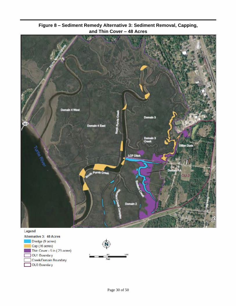
6.3 Alternative 3: Sediment Removal, Capping and Thin-Cover Placement – 48 Acres
Estimated Capital Costs: $ 37.6 million
Estimated O&M Costs: $1.4 million
Estimated Present Worth Costs: $38.7 million
Estimated Construction Time Frame: 3-to-4 years
Alternative 3 addresses PRGs in a 48-acre remediation area by combining sediment removal, sediment
capping, and thin-cover placement to accelerate natural recovery, ICs (as described for Alternative 2),
and LTM. This alternative targets the same SWAC PRGs and benthic community PRGs as Alternative
2, with the same area footprint.
This alternative includes sediment removal and backfilling in Eastern Creek, Western Creek, and LCP
Ditch and capping in Purvis Creek and Domain 3 Creek. Thin covers would be placed within Dillon
Duck and the vegetated marshes of Domains 1a, 2 and 3 as shown on Figure 8.
This alternative includes:
Dredging approximately 9 acres (~27,000 CY) to a target depth of 18 inches;
Backfilling with 12 inches (approximately 17,000 CY) of clean material (e.g., sand);
Capping approximately 16 acres with an isolation layer of clean material of at least 6 inches and
at least 6 inches of an armored layer of coarse sand and/or gravel;
Thin-cover capping on approximately 23 acres;
Dewatering sediments on-site and disposing of them at a licensed offsite facility;
Treating dewatered liquids, prior to discharge to the marsh; and
Constructing various staging areas and temporary access roads to facilitate material management
and sediment excavation (approximately 8 additional acres of disturbance).
Short and long term monitoring will be implemented as described above under Alternative 2. In
addition, although caps are designed to withstand high-energy flows, they may require repairs if
damaged by erosion or unexpected conditions, such as storm events. The extent of these potential
repairs will be evaluated during Site inspections.
Sediment caps isolate underlying sediment contaminants; control contaminant migration, physical
erosion and biological contact with underlying sediment contaminants; and provide a clean sediment
surface for habitat restoration. Modeling was used to design the thickness and material size for the cap
armor layer to ensure that the cap retains its integrity under worst case shear stress conditions.
Contaminant isolation modeling concluded that a 6-inch base isolation layer with up to 6 inches of
coarse sand-to-gravel armoring will adequately protect against contaminant migration through the cap,
as well as erosive forces resulting from storm events. Cap placement could be performed as a barge-
based operation in north and south Purvis Creek and as a land-based operation in Domain 3 Creek.
Page 30 of 50
Figure 8 – Sediment Remedy Alternative 3: Sediment Removal, Capping,
and Thin Cover – 48 Acres
Legend
Alternative 3: 48 Acres
- Dr<>dge (9 acr<><) - Cap ( 16 acres) - Thin C:ov"r - fi in ( n •~"'<) D OU1 lioun~aJy D C:rAAkif)orn:>in Rounrhry
D OU3 lioun~aJy
.. ""' Feet
Page 31 of 50
Given shallow water depths, narrow creeks and tidal effects, the cap may need to be placed by small
mechanical equipment (e.g., backhoe or similar excavator with a fixed arm or a telescoping conveyor
belt) operating from the shoreline and/or a shallow-draft barge.
The horizontal extent of the thin-cover placement for Alternative 3 is shown on Figure 8. The proposed
thin-cover placement area is approximately 23 acres. Thin covers consisting of 6 inches of clean
sediment or sand are targeted for the lower contaminant concentration, low-energy environments within
OU1 to accelerate ongoing natural recovery processes (e.g., contaminant burial), reduce risks to human
health and the environment, and provide a clean sediment surface for habitat restoration. Thin-cover
placement is best suited for wetlands or marsh environments where tidal energy and potential erosion is
at a minimum. Thin cover placement minimizes the negative ecological impacts of sediment capping
(e.g., loss of aquatic habitat, potential changes in marsh inundation patterns) and sediment removal (e.g.,
destruction of marsh habitat, areas of limited accessibility). It is recognized that some bioturbation will
occur through the thin cover by deep-burrowing macroinvertebrates, but that the resulting sediment
COC concentrations in those disturbed areas would be still be within the PRGs.
6.4 Alternative 4: Sediment Removal – 18 Acres
Estimated Capital Costs: $ 33.8 million
Estimated O&M Costs: $ 257,000
Estimated Present Worth Costs: $ 34.1 million
Estimated Construction Time Frame: 2 years
Alternative 4 addresses exceedances of the proposed PRGs in the 18-acre remediation area by
combining sediment removal, ICs (such as administrative and legal controls to minimize the potential
for exposure and to ensure the long-term integrity of the remedy), and LTM. This alternative targets the
SWAC PRGs for human health, mammals, and birds at 2 mg/kg for mercury and 4 mg/kg for Aroclor
1268. In addition, the upper-ends of the benthic community PRGs are targeted (i.e., 11 mg/kg for
mercury, 16 mg/kg for Aroclor 1268; 177 mg/kg lead, and 4 mg/kg for total PAHs).
This remedial alternative includes sediment removal and backfilling which would be performed in parts
of Eastern Creek, the LCP Ditch, the Domain 3 Creek, Dillon Duck and the vegetated marsh areas of
Domains 1a and 2 (Figure 9):
Dredging approximately 18 acres (~ 57,000 CY) to a target depth of 18 inches;
Backfilling with 12 inches (~ 36,000 CY) of clean material such as sand;
Dewatering sediments on-site and disposing offsite at a licensed facility;
Treating dewatering liquids, prior to discharge to the marsh; and
Constructing staging areas and temporary access roads to facilitate material management and
sediment excavation (approximately 11 additional acres of disturbance).
Short-term monitoring activities will span the construction phase and will be defined during the remedy
design phase. Some of these activities could include soundings and surveys to verify removal depths,
depth verification measurements to document backfill material placed, and/or backfill material coverage
assessments.

Page 32 of 50
Figure 9 – Sediment Remedy Alternative 4: Sediment Removal – 18 Acres
Legend
Altemotive 4: 1ti Aae..s
- Dr~g~,c> AII ( 18 :JC!f:'S)
D OU1 Cloundary c::J Cn:•f.:JJDuru:..•l Bounda~y
0 0 U38oundary

Page 33 of 50
Long-term remedy monitoring measures the remedy’s long-term effectiveness in enhancing ecosystem
recovery and reducing risks to human health and the environment. Details of the long-term monitoring
program will be specified in the ROD and are expected to include the components that are listed under
Alternative 2.
6.5 Alternative 5: Sediment Removal, Capping and Thin-Cover Placement – 18 Acres
Estimated Capital Costs: $ 25.6 million
Estimated O&M Costs: $ 475,000
Estimated Present Worth Costs: $ 26.0 million
Estimated Construction Time Frame: 2 years
This alternative targets the same SWAC PRGs and benthic community PRGs as Alternative 4 with the
same area footprint. It combines sediment removal, sediment capping and thin-cover placement to
accelerate natural recovery, ICs (such as administrative and legal controls to minimize the potential for
exposure and to ensure the long-term integrity of the remedy), and LTM.
This alternative (Figure 10) incorporates the following components:
Dredging approximately 7 acres (~22,000 CY) in the LCP Ditch and Eastern Creek to a depth of
18 inches;
Backfilling dredged area with 12 inches (~14,000 CY) of clean material;
Capping approximately 3 acres of Domain 3 Creek;
Thin-cover capping approximately 8 acres with clean sediment or sand;
Dewatering sediment on-site and disposing of it at licensed offsite facilities;
Treating the dewatered liquids, prior to discharge to the marsh; and
Constructing staging areas and temporary access roads which will require approximately 8 acres
of additional disturbance beyond the 18-acre footprint.
Short and long term monitoring will be implemented as described above under Alternative 2. In
addition, although caps are designed to withstand high-energy flows, they may require repairs if
damaged by erosion or unexpected conditions, such as storm events. The extent of these potential
repairs will be evaluated during Site inspections.
Sediment caps isolate underlying sediment contaminants; control contaminant migration, physical
erosion and biological contact with underlying sediment contaminants; and provide a clean sediment
surface for habitat restoration. Modeling was used to design the thickness and material size for the cap
armor layer to ensure that the cap retains its integrity under worst case shear stress conditions.
Contaminant isolation modeling concluded that a 6-inch base isolation layer with up to 6 inches of
coarse sand-to-gravel armoring will adequately protect against contaminant migration through the cap,
as well as erosive forces resulting from storm events. Cap placement could be performed as a land-
based operation (Domain 3 Creek). Given the shallow water depths, narrow creeks and tidal effects, the
cap may need to be placed by small mechanical equipment (e.g., backhoe or similar excavator with a
fixed arm or a telescoping conveyor belt) operating from the shoreline and/or a shallow-draft barge.

Page 34 of 50
Figure 10 – Sediment Remedy Alternative 5: Sediment Removal, Capping, and Thin
Cover – 18 Acres
l egend Aht>u r;,tti•Jf:' S: 18 Ac:rl's
- Ort.ocJg..- ( 7 :.m~:>s) • c.,r P . ,...,.) - I tun <.;ove.- - 6 rn ( ~ ocres) D OUl Boun<b"lry I Crcck/Doma n Bouncbry D CU3 Boun<l>ry
(.i·.-~ ,If'/

Page 35 of 50
Land-based access to the Domain 3 Creek requires construction of a small number of temporary access
roads across the soft sediments of Domain 3 marshes and Uplands areas. Construction of various
material staging areas (8 acres) is also required to facilitate material management and sediment cap
placement. While the anticipated amount of submerged debris is relatively high, since the proposed
sediment removal areas have not been periodically maintained, debris will remain in place unless it
interferes with capping operations. Any removed debris will be disposed of off-site at licensed facilities.
The boundaries of thin-cover placement for Alternative 5 are shown on Figure 10. The proposed thin-
cover placement area is approximately eight acres. Thin covers consisting of 6 inches of clean sediment
or sand are targeted for the lower contaminant concentration, low-energy environments within OU1 to
accelerate ongoing natural recovery processes (e.g., contaminant burial), reduce risks to human health
and the environment, and provide a clean sediment surface for habitat restoration. Thin-cover placement
is best suited for wetlands or marsh environments where tidal energy and potential erosion is at a
minimum. Thin cover placement minimizes the negative ecological impacts of sediment capping (e.g.,
loss of aquatic habitat, potential changes in marsh inundation patterns) and sediment removal (e.g.,
destruction of marsh habitat, areas of limited accessibility).
6.6 Alternative 6 (Preferred Remedy): Sediment Removal, Capping and Thin-Cover
Placement – 24 Acres
Estimated Capital Costs: $ 27.9 million
Estimated O&M Costs: $ 673,000
Estimated Present Worth Costs: $ 28.6 million
Estimated Construction Time Frame: 2 years
Alternative 6 addresses exceedances of PRGs in the 18-acre remediation area by combining sediment
removal, sediment capping and thin-cover placement to accelerate natural recovery, ICs (such as
administrative and legal controls to minimize the potential for exposure and to ensure the long-term
integrity of the remedy) and LTM. This alternative targets the SWAC PRGs for human health,
mammals and birds at 2 mg/kg for mercury, and 4 mg/kg for Aroclor 1268. In addition, the upper-end
of the benthic community PRGs are targeted, similar to Alternatives 4 and 5.
Alternative 6 addresses six more acres in Purvis Creek and Domain 1a than Alternatives 4 and 5, for a
total of 24 acres (Figure 11). These additional areas were included in the footprint for this alternative
for the following reasons:
Addressing areas in Purvis Creek and Domain 1 helps achieve lower SWAC-based PRGs for
mercury and Aroclor 1268;
Because most of Purvis Creek is permanently submerged, even at low tide, exposure times for
fish and piscivorous wildlife are longest in Purvis Creek;
Purvis Creek is relatively accessible from water so remedial actions in the creek will not
adversely or significantly impact vegetated marsh areas beyond impacts already contemplated
for Alternatives 4 or 5; and
The additional remedial area in Domain 1 is located immediately adjacent to areas where other
work (i.e., work in LCP Ditch and Eastern Creek) is already planned, making expansion into
Domain 1 easily implementable with minimal additional marsh impacts.

Page 36 of 50
Figure 11 – Sediment Remedy Alternative 6: Sediment Removal, Capping, and
Thin Cover – 24 Acres
L~gend
Altcrn~tive f>: 24 Acres
- Ou,•Jy~,c> ( 7 a4.:1 ~) - (;ap ( o acre~) - Thin Cover 5 n ( n acrco)
O OUI Bound:¥)1 D CreekiDJmain Ooundar:t D OU3 Bound:oy

Page 37 of 50
Remedial components of this alternative include:
Dredging approximately 7 acres (~22,000 CY) in the LCP Ditch and Eastern Creek to a target
depth of 18 inches;
Backfilling dredged areas with 12 inches (~14,000 CY) of clean material;
Capping approximately 6 acres in Domain 3 Creek and Purvis Creek;
Thin-cover capping approximately 11 acres of marsh;
Dewatering sediments on-site and disposing of them at licensed offsite facilities;
Treating the dewatered liquids, prior to discharge to the marsh; and
Constructing various staging areas and temporary access roads, which will require an additional
disturbance of approximately 7 acres, beyond the 24 acres of active remediation.
As indicated in the Alternative 3 discussion, thin cover caps are targeted for the lower contaminant
concentration, low-energy environments within OU1 to accelerate natural recovery processes (i.e.,
contaminant burial), reduce risks to human health and the environment, and provide a clean sediment
surface for habitat restoration.
Details of the long-term monitoring program will be specified in the ROD and may include the
following:
Physical measurements to monitor the integrity of backfilled areas (e.g., bathymetric surveys,
push cores, or visual observation via camera or video profiling);
Visual observations and surveys of marsh recovery, including plant growth and plant density;
Chemical measurements in tissues of fish and shellfish;
Chemical measurements in sediment; and
Surface water sampling as necessary to monitor compliance with ARARs.
In addition, although caps are designed to withstand high-energy flows, they may require repairs if
damaged by erosion or unexpected conditions, such as storm events. The extent of these potential
repairs will be evaluated during Site inspections.
7.0 COMPARATIVE ANALYSIS OF ALTERNATIVES
This section summarizes the comparison of each alternative to the nine CERCLA evaluation criteria and
to each other.
7.1 Overall Protection of Human Health and the Environment
Alternatives 2 through 6 are protective of human health and environment because they are designed to
comply with ARARs and RAOs and are within the protective PRGs ranges. Although not all individual
sediment stations, domains, and creeks meet the acceptable PRG risk ranges, such as mercury in the
Domain 3 Creek (Table 6), they are protective of the local ecosystem when the creeks and/or domains
are considered collectively.
Each alternative results in reduction of mercury sediment concentrations. All the creeks and domains
meet the 2 mg/kg mercury SWAC PRG, except Domain 3 Creek (3.7 mg/kg) and the Western Creek
Complex (2.1 mg/kg). Only very small discontinuous segments in these two creeks that comprise

Page 38 of 50
approximately three percent of the total creeks habitat exceed the PRG. However, when all creeks are
combined, the mercury SWAC is met (Table 6).
Under each alternative (except the no-action alternative) all creeks and domains will be reduced to
below the SWAC proposed PRG of 3 mg/kg for Aroclor 1268. Compared to Alternatives 2, 3 and 6,
Alternatives 4 and 5 are less protective because they do not result in a change in the Aroclor 1268
exposure concentration of 3.6 mg/kg in Purvis Creek (Table 6). This concentration is slightly below the
acceptable excess cancer risk of 1E-04 for the high quantity finfish consumer. Mercury is also reduced
in the Purvis Creek and in Domain 1 marsh.
Each alternative (except no-action) is predicted to result in reductions of mercury and Aroclor 1268
levels in finfish and shellfish concentrations sufficient to meet fish tissue goals for human health and
justify an eventual end to the consumption advisories within the TRBE. These reductions are likely to
be observed only after several years post remediation (i.e., after a few generations of fish lifespans).
The larger remedy footprint associated with Alternatives 2 and 3 achieve lower residual COC
concentrations than the smaller remedy footprints associated with Alternatives 4, 5 and 6. However, the
larger footprints would result in more impacts to the existing benthic habitat. The benefit of remediating
all areas to the lower end of the benthic PRGs should be balanced against the physical impacts of the
remedy, so that the remedy itself does not do disproportionate harm to the marsh ecosystem.
Surface water quality is expected to improve with each alternative except the No Action Alternative.
Therefore, the surface water quality criteria is expected to be achieved, as will the requirements of RAO
6. The lower surface sediment COC concentrations achieved by each of the alternatives, except the No
Action Alternative, will substantially decrease the potential for the suspension and transport of
contaminated sediment particles. Alternatives 2 through 6 are expected to achieve federal and state
water quality criteria for dissolved-phase and total mercury and Aroclor 1268.
7.2 Compliance with ARARs
Section 121(d)(2) of CERCLA requires that remedial actions must comply with federal and more
stringent state environmental laws or regulations that are legally “applicable” or “relevant and
appropriate” (commonly referred to as “ARARs”) under the circumstances of the release or threatened
release of such hazardous substance or pollutant or contaminant. Further, the NCP at 40 C.F.R. §
300.435(b)(2) requires remedies to attain, or waive under CERCLA Section 121(d)(4), ARARs during
the course of a remedial action.
For ease of identification, EPA has classified ARARs into three categories, chemical-, action-, and
location-specific. Chemical-specific ARARs are health- or risk-based numerical values or
methodologies which, when applied to site-specific conditions, result in the establishment of numeric
values. These values establish an acceptable amount or concentration of a chemical that may remain in,
or be discharged to, the ambient environment. The State of Georgian water quality criteria for mercury
and total PCBs are considered relevant and appropriates standards that are expected to be attained in the
OU1 surface water bodies. Location-specific ARARs are restrictions on hazardous substances or the
conduct of response activities solely based on their location in a special geographic area (e.g. wetlands,
watersheds, floodplains, sensitive habitats, coastal zones, historic places). Action-specific ARARs are
technology- or activity-based requirements or limits on actions taken with respect to particular
hazardous substance or waste type (e.g., RCRA hazardous waste or TSCA PCB waste). These

Page 39 of 50
requirements are triggered by a particular remedial activity (e.g., excavate soil, stage waste in pile or
containers, treat, dispose, emit, discharge to surface water, cap with waste in place, etc.).
A list of potential federal and State of Georgia ARARs (Chemical-, Location- and Action-specific) is
included in the FS which in accordance with NCP was considered when evaluating each of the remedial
alternatives. Final ARARs for the selected remedy to attain will be included in the ROD for OU1.
7.3 Long Term Effectiveness and Permanence
Other than the No Action Alternative, all alternatives include measures for long-term human health and
ecological risk reduction by targeting site-specific exceedances of PRGs for removal, capping, or thin-
cover placement, thus reducing risk of exposure to contaminated material. Sediment removal, sediment
capping, and to a lesser degree thin-cover placement have been found reliable and effective at sites
similar to the LCP Chemicals marsh.
Sediment removal would permanently remove COCs from the LCP Chemicals marsh and backfilling
would permanently address post-removal residuals. Capping and thin covers are engineered to account
for hydrodynamic conditions to ensure their permanence. Overall the LCP Chemicals marsh is
characterized as stable and relatively resistant to scour and sediment re-suspension. The results from
hydrodynamic model simulations demonstrated relatively low velocities (generally less than 2 ft/sec)
throughout the LCP Chemicals marsh during spring-neap tidal cycles, 100-year flood conditions, and
hurricane storm surge conditions. Velocities that could result in cap material instability are addressed
through armoring to resist erosion.
Materials for sediment capping and thin-cover placement will be sized to ensure protection against
erosion and scour. However, the thin cover is not an armored contaminant barrier. Based on several
case studies, some burrowing and other types of biological activities will occur in the thin-cover layer,
but are not expected to adversely impact its effectiveness in reducing exposures to the benthic
community. Monitoring and maintenance will be performed as necessary to ensure long-term remedy
effectiveness.
ICs (e.g., land use or deed restrictions, maintenance agreements, permits limiting land use for future
activities and fish consumptions advisories) will be used, as necessary, to control residual risks
following remedy implementation. In addition, LTM ensures confirmation of long-term structural
integrity and effectiveness.
7.4 Reduction of Toxicity, Mobility, or Volume (TMV) through Treatment
Alternative 1 provides no reduction in risk to humans or the environment beyond current on-going
natural processes. In Purvis Creek, there is evidence that mercury fish and shellfish tissue
concentrations have decreased over time. However, there is no clear evidence that Aroclor 1268 fish
tissue concentrations have decreased in Purvis Creek. Therefore, Alternative 1 may not satisfy the RAO
goals over the long-term. It is not clear how long it would take to reduce fish tissue levels, and without
monitoring, risk reduction cannot be confirmed. Therefore, the No Action Alternative does not provide
adequate risk reduction or adequately address residual risk for human health and some ecological
receptors.

Page 40 of 50
All of the other alternatives include varying degrees of sediment removal, which reduces of the volume
of COC-impacted sediment in the marsh following remedy implementation. Where alternatives include
sediment capping and thin-cover placement, long-term COC toxicity and mobility are reduced by
creating a clean sediment surface through burial with clean materials. The thin cover is not intended to
function as an absolute contaminant barrier, but as a layer which will stimulate ongoing natural recovery
processes. Therefore, some possible bioturbation beyond the cover depth is not expected to diminish the
effectiveness of this remedy and would not preclude its beneficial use as a component of a protective
remedy.
Alternatives 2 through 6 target cleanup of sediments that exceed benthic PRGs. Although these
alternatives address an acceptable risk range for the benthic community, residual risks may occur with
varying degrees. Alternatives 2 and 3 are expected to have less residual risks to the benthic community
than Alternatives 4 and 5.
Sediment removal permanently eliminates long-term risks of exposure since contaminated material is
removed. Backfilling addresses dredge residuals that otherwise pose risks. Capping and thin-cover
placements, which leave contaminant material in place, isolate COCs and reduce bioavailability and
mobility through burial with clean material.
Residual risks posed by COCs left un-remediated are addressed through ICs (including permit
requirements, which are already in place to limit use or future activities in the LCP Chemicals marsh and
fish consumption advisories) and LTM. The ICs and LTM will help ensure the remedy’s long-term
structural integrity and effectiveness in reducing COC concentrations in fish/shellfish as well as the
achievement of RAO 4 for the affected benthic community.
7.5 Short-term Effectiveness
Implementation of any alternative, other than the No Action Alternative, presents short-term impacts
associated with on-site construction and remediation operations. As indicated below, the extent of these
impacts is proportional to the remedial footprint, the sediment removal volume, the selected remedy
components, the time required to complete the remedy, and on-site material handling requirements.
Alternative 2 includes the removal of 153,000 CY of contaminated sediment material from 48 acres of
OU1 and construction is estimated to span 3-to-4 years. Thus, Alternative 2 poses greater short-term
risks and potential impacts to human health and the environment than the rest of the alternatives.
Alternatives 3 and 4 require the removal, transportation, and disposal of 27,000 and 57,000 CY of
contaminated material from nine and 18 acres, respectively. These volumes represent approximately
18 % and 37%, respectively, of the 153,000 CY volume considered for removal in Alternative 2. Based
strictly on the volume of contaminated materials to be removed, Alternative 2 poses greater short-term
impacts than Alternative 3 and 4. These negative impacts primarily relate to extensive heavy equipment
used for dredging and the transport of contaminated sediments through the community to an uplands
disposal facility and clean material transport to the Site. Since the negative short-term human health and
ecological impacts of sediment capping and thin-cover placement are generally associated with
transportation of the clean material and heavy equipment usage, short-term effectiveness strongly
correlates to the duration of construction activities. The longer the construction time, the more risk of
such negative impacts. These impacts can be managed by best management practices (BMPs) and site-
specific safety plans. The estimated construction duration for the alternatives range from two years
Page 41 of 50
(Alternative 4, 5 and 6) to three-to-four years for Alternatives 2 and 3. Thus, 4, 5 and 6 provide greater
short term effectiveness than Alternatives 2 and 3 by one-to two years.
7.6 Implementability
There are no implementability constraints for the No Action Alternative because no remedial action is
taken.
Portions of each other alternative pose different challenges and technical difficulties associated with
remedy implementation. Since tides in the LCP Chemicals marsh will severely affect accessibility to
equipment, material and personnel, productivity will be severely impacted, regardless of whether a land-
or water-based operation is employed. Implementation of any remedial technology (whether sediment
removal, sediment capping or thin-cover placement) will encounter the following constraints:
As with other sediment remediation projects, the removal, transportation, off-loading,
dewatering/solidification, and disposal of contaminated sediment and debris present significant
implementation challenges, such as traffic management, noise control, and suitable disposal
facility capacity identification.
Scattered debris has been observed throughout the LCP Chemicals marsh, including large stone
lining the banks of the LCP Ditch. Debris within removal areas will be removed and disposed of
off-site during remedy implementation.
There are technologies and techniques available to meet the challenges associated with working in soft
sediments in tidally influenced marsh areas. These include employing low-ground-pressure earth-
moving equipment, telescoping conveyor belts for cap placement, shallow draft barges for water-based
sediment removal and sediment capping, and hydraulic equipment to place thin-cover material. Most of
these issues will be resolved during design and the construction bidding process.
7.7 Costs
Thirty-year net-present value costs for each alternative, calculated with a 7% discount rate, were
presented for each alternative. The basis of cost estimates and assumptions made in developing these
estimates are detailed in Appendix H of the June 2014 draft of the FS.
7.8 State/Support Agency Acceptance
The State of Georgia supports the Preferred Alternative.
7.9 Community Acceptance
Community acceptance of the preferred alternative will be evaluated after the public comment period
ends and will be described in the OU1 ROD.
8.0 PROPOSED CLEANUP LEVELS
Cleanup levels (CULs) for the LCP Chemicals marsh were developed by weighing numerous factors,
including the uncertainties associated with the PRG acceptable risk range and analyzing the nine NCP
criteria described above for each alternative. The derivation of the ecologically-based CULs was also a
complex process that involved consideration of the ecological relationship of the affected areas of
remedy implementation to the surrounding habitat, the recovery potential of the affected ecological
receptors, and the magnitude of current and predicted future effects of the COCs on local populations

Page 42 of 50
within the marsh. Further, it was clear that not all discontinuous or isolated sediment locations that
exceed PRGs could be removed without causing more harm than benefit. Based on the evaluation of
these types of factors, the comparative analysis of alternatives above, and the predicted post-remedy
SWAC levels (Table 6), the following CULs are proposed.
COC Proposed SWAC CULs
(mg/kg)1
Proposed Benthic Community CULs
(mg/kg)2
Mercury 2 11
Aroclor 1268 3 16
Lead NA 177
PAHs NA 4
NA – Not applicable because lead and PAHs only affect benthic organisms.
1 - Surface weighted average concentrations, which provide for the protection of human health, wildlife and fish.
2 – Concentration for protection of benthic organisms, as measured by 50 by 50 meter grids.
The benthic community CULs are based on the PRGs and their associated uncertainties (Table 4). In
addition, the BERA described significant uncertainties associated with the derivation of PRGs based on
over 300 toxicity tests with low reliability. It also provided results of five different SECs on eight
toxicity test endpoints (e.g., survival, reproductive response) for the test organisms (amphipods and
grass shrimp), including attempts to normalize for organic carbon, for a total of 240 statistically derived
potential SECs. For mercury, there were 40 SECs (25 for grass shrimp and 15 for amphipods). In
accordance with the EPA’s risk assessment guidance, the initial PRGs were based on the most
conservative estimates, using the most sensitive sediment toxicity receptors and test endpoints. The
range of mercury SECs was between 1.4 and 145 mg/kg. For Aroclor 1268, the SEC range was between
4 and 420 mg/kg. Similarly for PAHs and lead, the SEC concentrations ranged over an order of
magnitude. Thus, the BERA PRGs were very conservative and did not take into account the locations or
magnitude of sediment contaminant distribution in the LCP Chemicals marsh.
During development of the FS, when the BERA PRGs were overlain over sediment contaminant
concentration distribution maps, it became apparent that very large areas of the marsh would be
disturbed to protect benthic organisms. After evaluating each alternative that was presented in the FS, it
was determined that the proposed CULs would still provide substantial protection to the benthic
community without undue harm to the existing marsh, especially in combination with a robust
monitoring program.
The proposed SWAC CULs are to be applied to each of the individual domains and to the total creeks
area. The benthic CULs are applied to the 50 by 50 meter grids as defined in the FS. The benthic
community CULs are not protective of human health, wildlife or fish and therefore cannot be exchanged
or substituted with any SWAC CUL.
Each of the SWAC and benthic community proposed CULs are expected to result in the attainment of
the RAOs. In addition, surface water criteria that are identified as chemical-specific ARARs are
expected, over time, to be attained as a result of dredging and capping of contaminated sediments.
Where CULs may not be achieved and residual risks in some areas may occur, CERCLA and the NCP
requires monitoring no less than every five years after implementation of the final remedy. Given that
COCs will be left in place, a robust monitoring program, with triggers for additional actions, will be

Page 43 of 50
implemented as part of the selected remedy for OU1 to monitor and ensure success of the selected
remedy.
9.0 SUMMARY OF THE PREFERRED ALTERNATIVE
The EPA Region 4’s preferred remedy for the LCP Chemicals marsh is Alternative 6 – Dredge, Cap
and Thin Cover.
Based on information currently available, the lead agency believes the Preferred Alternative for the LCP
Chemicals marsh meets the threshold criteria and provides the best balance of tradeoffs among other the
other alternatives with respect to the balancing and modifying criteria. The EPA expects the Preferred
Alternative to satisfy the following statutory requirements of CERCLA § 121 (b): 1) be protective of
human health and the environment; 2) comply with ARARs (or justify a waiver); 3) be cost-effective; 4)
utilize permanent solutions and alternative treatment technologies or resource recovery technologies to
the maximum extent practicable; and 5) satisfy the preference for treatment as a principal element (or
justify not meeting the preference).
This alternative will achieve the site-specific proposed CULs and satisfy the NCP requirements for
protectiveness, implementability, and permanence, while limiting the negative impacts associated with
disturbing sensitive habitat. The estimated construction timeframe of two years, at a cost of $28.6
million, is projected to reduce COCs to substantially lower concentrations in a relatively short timeframe
and at reasonable cost. Alternative 6 also provides a reasonable balance for achieving the RAOs while
minimizing disturbance to fragile areas of the marsh. Figure 11 provides detailed information on the
remedy’s footprint, relative to the available sediment sampling results. Major activities include:
Dredging of seven acres of the LCP Ditch and Eastern Creek to a target depth of 18 inches and
backfill with 12 inches of clean material. Dredged sediments will be taken to a licensed disposal
facility;
Capping of six acres of the Domain 3 Creek and Purvis Creek South; and
Thin cover placement on eleven acres of the Dillon Duck, Domain 1A and Domain 2.
Approximately 22,000 CY of contaminated sediment in the LCP Ditch and Eastern Creek will be
dredged to a depth of 18 inches and properly disposed of. The dredged areas would be backfilled with
12 inches of clean material. Approximately 14,000 CY of cap would be placed over a six acre area in
Domain 3 Creek and Purvis Creek. In addition, approximately 13,000 CY of thin-layer cover would be
placed over 11 acres of marsh surface.
Alternative 6 includes long-term monitoring of the capping, thin-layer cover and the marsh restoration
areas. Biological monitoring will also be part of the long-term monitoring program. EPA will require
monitoring of BMPs to manage dredge and other construction-related releases and will evaluate
performance data and make necessary adjustments.
Expected residual risks associated with the preferred remedy include:
RAO 1 – Minimal residual risks would be expected since the primary contaminated source areas
in the LCP Ditch and Eastern Creek would be dredged. Residual contamination in the Western
Creek Complex and Domain 3 Creek is not expected to contribute any substantial releases of
COCs to Purvis Creek.

Page 44 of 50
RAO 2 – LOAEL risks to piscivorous birds and mammals will be reduced to an HI of 1 or less.
Fish tissue concentrations are expected to be reduced within several of years after post
construction and monitoring of fish and shellfish will occur to assess remedy effectiveness.
RAO 3 – The predicted high quantity finfish consumer excess cancer risk for Aroclor 1268 will
be reduced to acceptable levels. Similar to RAO 2, the fish tissue concentrations are anticipated
to decrease several years after construction is complete.
RAO 4 – Residual risks to the benthic community are expected in those areas where COC
concentrations exceed the CULs, such as in isolated areas in the Western Creek Complex and in
Domain 3. However, it is not expected that these relatively isolated exceedances would
adversely impact the overall benthic community in the various creeks and domains.
For RAO 5 – LOAEL finfish exposures would be reduced to HQs less than 1, with the likely
exception of stripped mullet exposure to Aroclor 1268.
RAO 6 – It is anticipated that the applicable EPA and State of Georgia water quality standards
will be met a number of years after construction is complete and that any residual risks from
COCs in surface water would not be significant.
10.0 COMMUNITY PARTICIPATION
EPA and the GAEPD will provide information regarding the cleanup of the LCP Chemicals marsh to the
public through public meetings, the AR file for the OU, and announcements published in the Brunswick
News. EPA and GAEPD encourage the public to review the documents available for a comprehensive
understanding of this OU and the entire Site, as well as the Superfund activities that have been
conducted to date at the Site.
The dates for the public comment period, the date, location, and the time of the public meeting, and the
locations of the AR files are provided on the front page of this Proposed Plan.

Page 45 of 50
Public Meeting
As a part of the public involvement process, a public meeting is scheduled on December 4, 2014. The
meeting will be held at the Brunswick-Glynn County Library, Brunswick, GA at 6:00 pm. At this
meeting, the EPA will present the information it has about the Site, describe its reasons for selecting the
preferred alternative outlined in the Proposed Plan, and answer any questions. Oral and written
comments will be accepted at the meeting.
For more information, see the Administrative Record at the following locations:
Brunswick-Glynn Co. Library U.S. EPA - Region 4
208 Gloucester Street Center Superfund Records Center
Brunswick, GA 31520 61 Forsyth St., SW
(912) 267-1212 Atlanta, GA 30303

Page 46 of 50
GLOSSARY
Administrative Record: Documents, including
correspondence, public comments, Records of
Decision and other decision documents, and
technical reports upon which the agencies base
their remedial action selection.
Amphipod: A small, shrimp-like crustacean.
Apparent effects threshold (AET): The
sediment concentration for a chemical above
which a particular adverse biological effect is
always expected.
Applicable or Relevant and Appropriate
Requirements (ARARs): ARARs are any
promulgated standards, requirements, criteria, or
limitations under federal environmental laws, or
any promulgated standards, requirements,
criteria, or limitations under state environmental
or siting laws that are more stringent than
federal requirements, that are either legally
‘applicable or relevant and appropriate’ under
the circumstances. Under CERCLA Section
121(d), a remedial action must comply (or
justify a waiver) with ARARs.
Aroclor: A discontinued registered trademark
for a series of polychlorinated biphenyl (PCB)
compounds. Aroclor was first sold in 1930. It
was available as viscous oils and thermoplastic
solids with high refractive indices. Aroclor is no
longer used because of its high toxicity. Aroclor
production was discontinued in the United
States in 1977.
Baseline Risk Assessment: A qualitative and
quantitative evaluation performed in an effort to
define the risk posed to human health and the
environment by the presence or potential
presence of specific contaminants.
Benthic invertebrates: Small but visible
animals (e.g., insects, worms, clams, and snails)
that live in or on the sediment at the bottom of a
marsh, lake, or stream.
Bioaccumulation: The uptake and storage of
chemicals by living animals and plants. This can
occur through direct contact with contaminated
water or sediment or through the ingestion of
another organism that is contaminated. For
example, a small fish might eat contaminated
algae, a bigger fish might eat several
contaminated fish and a human might eat a
bigger, now-contaminated fish. Contaminants
typically increase in concentration as they move
up the food chain.
Bioavailability: Degree of ability to be
absorbed and metabolized in an organism.
Bioturbation: The process whereby bottom
dwelling and burrowing organisms mix-up
sediment and destroy primary layering.
Cancer slope factor: Used to estimate the risk
of cancer associated with exposure to a
carcinogenic or potentially carcinogenic
substance. A slope factor is an upper bound,
approximating a 95% confidence limit, on the
increased cancer risk from a lifetime exposure
to an agent by ingestion or inhalation.
Chlor-alkali: There are three production
methods for producing chlorine and sodium
hydroxide in use. The mercury cell method
produces chlorine-free sodium hydroxide. In a
normal production cycle a few hundred pounds
of mercury per year are emitted, which
accumulate in the environment. Additionally,
the chlorine and sodium hydroxide produced via
the mercury-cell chlor-alkali process are
themselves contaminated with trace amounts of
mercury. The membrane and diaphragm
method use no mercury, but the sodium
hydroxide contains chlorine, which must be
removed.

Page 47 of 50
Clapper Rail: The Clapper Rail is a chicken-
sized game bird that rarely flies. It is grayish
brown with a pale chestnut breast and a
noticeable white patch under the tail.
Comprehensive Environmental Response,
Compensation and Liability Act (CERCLA):
A federal law (also known as Superfund)
passed in 1980 and modified in 1986 by the
Superfund Amendment and Reauthorization Act
(SARA); the act authorizes EPA to investigate
and cleanup abandoned or uncontrolled
hazardous waste sites. The law authorizes the
federal government to respond directly to
releases of hazardous substances that may
endanger public health or the environment.
EPA is responsible for managing the Superfund.
Contaminant of Concern: A hazardous
substance or group of substances that pose
unacceptable risk to human health or the
environment at a site.
Dewatering: Removal of water from solid
material or soil by wet classification,
centrifugation, filtration, or similar solid-liquid
separation processes, such as removal of
residual liquid from a filter cake by a filter press
as part of various industrial processes.
Dioxin/furans: Dioxins and furans are the
abbreviated or short names for a family of toxic
substances that all share a similar chemical
structure. Dioxins, in their purest form, look like
crystals or a colorless solid. Most dioxins and
furans are not man-made or produced
intentionally, but are created when other
chemicals or products are made. Of all of the
dioxins and furans, one, 2,3,7,8-tetrachloro-p-
dibenzo-dioxin (2,3,7,8 TCDD,) is considered
the most toxic.
Discharge: Flow of surface water in a stream
or the outflow of groundwater from a flowing
well, ditch, or spring. It can also apply to
release of liquid effluent from a facility or to
chemical emissions into the air.
Ecological Risk Assessment: The application
of a formal framework, analytical process, or
model to estimate the effects of human actions
on a natural resource and to interpret the
significance of those effects in light of the
uncertainties identified in each component of
the assessment process. Such analysis includes
initial hazard identification, exposure and
dose/response assessments, and risk
characterization.
Effects range-low (ER-L): The concentration
of a contaminant above which harmful effects
may be expected to occur.
Effects range-medium (ER-M): The
concentration of a contaminant above which
harmful effects always or almost always occur.
Feasibility Study: A study of the applicability
or practicability of a proposed action or plan
conducted after the Remedial Investigation to
determine what alternatives or technologies
could be applicable to clean up the site-specific
COCs.
Grass shrimp: A very small shrimp that lives
among the marsh grasses in fresh and brackish
waterways in many parts of the eastern United
States. They are pinkish in color but so pale as
to be almost transparent, with yellowish eye
stalks protruding from their heads. These shrimp
are also sometimes called popcorn shrimp.
Hazard Index (HI): The sum of more than one
hazard quotient for multiple substances and/or
multiple exposure pathways.
Hazard Quotient (HQ): The ratio of an
exposure level to a substance to a toxicity value
selected for the risk assessment for that
substance.
Heavy metals: Metallic elements with high
atomic weight, e.g., mercury, chromium,

Page 48 of 50
cadmium, arsenic, and lead. They can damage
living things at low concentrations and tend to
accumulate in the food chain.
Herbivorous: Feeds on plants.
Human Health Risk Assessment: A qualitative
and quantitative evaluation performed in an
effort to define the risk posed to human health
by the presence or potential presence of specific
contaminants.
Information Repository: A library or other
location where documents and data related to a
Superfund project are placed to allow public
access to the material.
Institutional Controls: Restriction that
prevents an owner inappropriately using a
property. The restriction is designed to reduce
exposure to hazardous substances for workers or
the general public and maintain the integrity of
the remedy.
Lowest-observed-adverse-effects-level: The
lowest level of a chemical stressor evaluated in
a toxicity test that shows harmful effects on a
plant or animal.
Macroinvertebrate: An invertebrate that is
large enough to be seen without the use of a
microscope
Mercury Cell Process: In the mercury cell
process, sodium forms an amalgam (a “mixture”
of two metals) with the mercury at the cathode.
The amalgam reacts with the water in a separate
reactor called a decomposer where hydrogen gas
and caustic soda solution at 50% are produced.
The products are extremely pure. The chlorine
gas, produced at the anode, contain a small
amount of oxygen and can generally be used
without further purification.
Methylation: The addition of a methyl group,
CH3, to a molecule.
Mummichog: A small killifish found in the
eastern United States. Also known as mummies,
gudgeons, and mud minnows, these fish are
found in brackish and coastal waters including
estuaries and salt marshes along the eastern
seaboard of the United States as well as the
Atlantic coast of Canada. The mummichog is a
popular research subject in toxicological studies.
Mysids: Mysida is an order of small, shrimp-
like crustaceans in the malacostracan superorder
Peracarida. Their common name opossum
shrimps stems from the presence of a brood
pouch or "marsupium" in females.
Nanogram: One billionth of a gram.
National Oil and Hazardous Substances
Pollution Contingency Plan (NCP): The
federal regulations governing CERCLA
cleanups and the determination of the sites to be
addressed under both the Superfund program
and Oil Pollution Act to prevent or control spills
into waters of the U.S. and elsewhere. 40 CFR
Part 300 et seq.
National Priorities List (NPL): List of high
priority sites with hazardous waste releases
which may be addressed by EPA's Superfund
program.
Net Present-Value Analysis/Present-Value
Cost: A method of evaluation of expenditures
that occur over different time periods. By
discounting all costs to a common base year, the
costs for different remedial action alternatives
can be compared. When calculating present
worth costs for Superfund sites, capital and
operation and maintenance costs are included.
No observed adverse effect level: The highest
level of a chemical stressor in a toxicity test that
did not cause harmful effect in a plant or animal.
Omnivorous: An animal that eats food from
both plants and animals, which may include
eggs, insects, fungi and algae. Many rely on
both vegetation and animal protein to remain
healthy.
Page 49 of 50
Operable Units (OUs): Separate activities
undertaken as part of a Superfund site cleanup.
Often a Superfund Site is divided in phases to
better address different pathways and areas of
contamination.
Persistence: Refers, in general, to the length of
time a compound remains in the environment,
once introduced. A compound may persist for
less than a second or indefinitely.
Piscivorous: Describes a carnivorous diet that
consists largely of fish, though a piscivorous
diet may also include similar aquatic foods such
as aquatic insects, mollusks and crustaceans.
Polycyclic Aromatic Hydrocarbons (PAHs):
Also known as poly-aromatic hydrocarbons or
polynuclear aromatic hydrocarbons, they are
fused aromatic rings and do not contain
heteroatoms or carry substituents. Naphthalene
is the simplest example of a PAH. PAHs occur
in oil, coal, and tar deposits and are produced as
byproducts of fuel burning (whether fossil fuel
or biomass).
Polychlorinated Biphenyl (PCB): A high
molecular-weight halogenated organic
compound formerly used in dielectric fluids in
transformers and other electrical equipment.
Probable effects level (PEL): A chemical
concentration in some item (dose) prey that is
ingested by an organism, which is likely to
cause an adverse effect. The ingested item is
usually food, but can be soil, sediment, or
surface water that is incidentally (accidentally)
ingested.
Proposed Plan: A Superfund public
participation fact sheet that summarizes the
preferred cleanup strategy for a Superfund Site.
Receptor: Entity exposed to a stressor.
Record of Decision (ROD): A legal, technical,
and public document that identifies the selected
remedy at a site, outlines the process used to
reach a decision on the remedy, and confirms
that the decision complies with CERCLA.
Reference Dose: An estimate (with uncertainty
spanning perhaps an order of magnitude) of a
daily oral exposure to the human population
(including sensitive subgroups) that is likely to
be without an appreciable risk of deleterious
effects during a lifetime. It can be derived from
a NOAEL, LOAEL, or benchmark dose, with
uncertainty factors generally applied to reflect
limitations of the data used. Generally used in
EPA's noncancer health assessments.
Reference Station: A sampling station believed
to be un-impacted by the site being investigated
and used for comparison purposes.
Remedial Action Objectives (RAOs): They
provide overall cleanup goals which guide the
comparison and selection of remedial options.
Remedial Design: A phase of remedial action
that follows the remedial investigation /
feasibility study and Record of Decision and
includes development of engineering drawings
and specifications for a site cleanup.
Remedial Investigation / Feasibility Study
(RI/FS): A two-part investigation conducted to
fully assess the nature and extent of a release, or
threat of release, of hazardous substances,
pollutants, or contaminants, and to identify
alternatives for cleanup. The Remedial
Investigation gathers the necessary data to
support the corresponding Feasibility Study.
Remediation: Cleanup or other methods used
to remove or contain a toxic spill or hazardous
substances from a Superfund site.
Residuals: Contaminants that are left in place
following remediation.
Responsiveness Summary: A summary of oral
and written comments received by EPA during a
comment period on key EPA documents, and
EPA’s responses to those comments. The
responsiveness summary is a key part of the
Page 50 of 50
ROD, highlighting community concerns for
EPA decision-makers.
Sediment effect concentrations: Sediment
quality guidelines used to predict sediment toxicity.
Site-specific SECs were derived for the LCP
Chemicals marsh based on the results of the acute
toxicity tests.
Semi-volatile Organic Compounds: Organic
chemicals that evaporate slowly at standard
temperature (70 degrees Fahrenheit).
Superfund: The common name for the program
operated under the legislative authority of the
Comprehensive Environmental Response,
Compensation and Liability Act of 1980
(CERCLA), the federal law that governs
cleanup of abandoned hazardous waste sites.
The Superfund Amendments and
Reauthorization Act (SARA) amended
CERCLA on October 17, 1986.
Surface Weighted Average Concentrations: The average contaminant concentration in the
biologically active portion of sediment.
Thin-cover placement: The placement of a thin
(typically six inches or less) layer of sediment,
sand or amendments to reduce exposure to
underlying sediments. Also referred to as thin
layer capping and enhanced natural recovery.
Threshold effects level (TEL): A chemical
concentration in some item (dose) that is
ingested by an organism, above which some
effect (or response) will be produced and below
which it will not. This item is usually food, but
can also be soil, sediment, or surface water that
is incidentally (accidentally) ingested as well.
Toxicity Equivalence Factor (TEF): Estimate
of the potency, relative to 2,3,7,8-TCDD,
of an individual polychlorinated dibenzo-p-
dioxin, dibenzofuran or biphenyl congener,
using careful scientific judgment after
considering all available relative potency data.
Toxicity Equivalence Concentration: The
TEC is the product of the TEF multiplied by the
concentration for an individual congener. The
total TEC for a mixture is calculated as the sum
of 2,3,7,8-TCDD equivalence concentrations of
all congeners present in the mixture.
Toxicity reference factor: Represents a daily
dose associated with an effect level or threshold
and is expressed in units of milligrams of
chemical per kilogram of body weight of the
wildlife receptor per day. TRVs are developed
in the effects assessment and used in the risk
characterization phases of a BERA.
Volatile organic compound: Chemicals that,
as liquids, evaporate into the air

MAILING LIST ADDITIONS/CORRECTIONS
LCP CHEMICALS SITE MAILING LIST
If you would like to be added to the mailing list for the LCP Chemicals Site, please complete this pre-
addressed form. If you have any questions regarding this mailing list, please call Angela Miller, EPA
Community Relations Coordinator, at 1-877-718-3752 (toll free).
NAME: _____________________________________________________________
ADDRESS: __________________________________________________________
CITY, STATE, ZIP: ___________________________________________________
TELEPHONE: (_____)_________________ AFFILIATION: _______________

USE THIS SPACE TO WRITE YOUR COMMENTS
Your input on the Proposed Plan for the LCP Chemicals Superfund Site is important in helping EPA select a
remedy for the site. Please use the space below to write your comments. Then fold and mail. A response to your
comments will be included in the Responsiveness Summary, an Appendix to the Record of Decision.
Note: In order to permit the community ample time to review and comment on this Proposed Plan, a 30 day
extension to the initial 30 day comment period has been allowed for, concluding the comment period on February
2, 2015.
_____________________________________________________________________________________
_____________________________________________________________________________________
_____________________________________________________________________________________
_____________________________________________________________________________________
_____________________________________________________________________________________
_____________________________________________________________________________________
_____________________________________________________________________________________
NAME: ___________________________________
ADDRESS: ________________________________
________________________________
------------------------------------------------------------------------------------------------------------
Name
Address
City State Zip
Superfund Remedial Branch
Waste Management Division
61 Forsyth St., SW
Atlanta, GA 30303
Place
Stamp
Here

LCP CHEMICAL SUPERFUND SITE
PUBLIC COMMENT SHEET
U. S. EPA, Region 4
Superfund Remedial Branch
Superfund Division
61 Forsyth St., SW
Atlanta, GA 30303

Fold on dashed lines, staple, stamp, and mail
Name__________________
Address ______________________
City _____________ State ___ Zip _____
Superfund Remedial Branch Waste Management Division U.S. EPA Region 4 61 Forsyth St., SW Atlanta, GA 30303
![Health Consultation CHemicals 10-2...health consultation for Linden Chemical and Plastics (LCP Chemicals), Brunswick, Georgia . in August 1994 [1].](https://static.fdocuments.net/doc/165x107/5b00b32e7f8b9a54578d09ec/health-consultation-chemicals-10-2health-consultation-for-linden-chemical-and.jpg)