LCP Chemicals Site - US EPA › ... › lcp_dec_4_2014_meeting.pdf · LCP Chemicals purchased...
39
LCP Chemicals Site OPERABLE UNIT 1 (Marsh) PROPOSED PLAN PUBLIC MEETING December 4, 201 4 Location: Brunswick-Glynn County Library 6:00 - 8:00 pm
Transcript of LCP Chemicals Site - US EPA › ... › lcp_dec_4_2014_meeting.pdf · LCP Chemicals purchased...

LCP Chemicals Site
OPERABLE UNIT 1 (Marsh) PROPOSED PLAN PUBLIC MEETING
December 4, 201 4 Location: Brunswick-Glynn County Library
6:00 - 8:00 pm

MEETING AGENDA
I. II. III. IV. V.
Welcome & Introduction Meeting Purpose & Overview of Superfund Process Site Description & History Key Components of the Proposed Plan Questions & Answers

The Superfund Process Removal

EPA's Mandate Under Superfund Remedia
Site Characterization (sampling to determine nature and extent); Conduct Baseline Risk Assessments to establish unacceptable risk Remedy selection; and Remedy implementation.
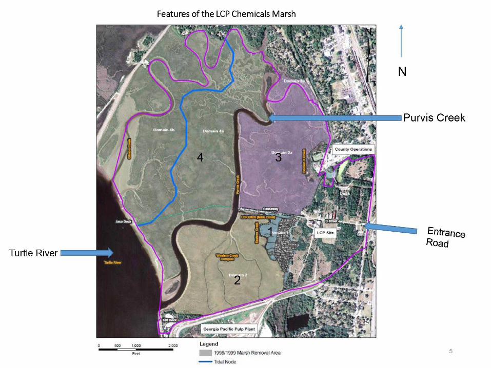
Features of the LCP Chemicals Marsh
Turtle River
500 1.000 Legend 1998/1999 Masn Removal Area TOai Node
Purvis Creek
^'^franc© Road

Site Industrial History Use began in 1836 with construction of the Brunswick-Altamaha Canal along the uplands and the marsh boundary;
ARCO used Site as a refinery from 1919-1929;
Georgia Power operated an oil-fired power plant from 1937 through 1950;
Dixie Paint and Varnish Co. purchased part of the Site in 1941 and operated a manufacturing facility until 1955;
Allied Chemical purchased the Site in 1955 and constructed and operated a chlor-alkali facility, utilizing the mercury-cell process. Main products were chlorine gas, hydrogen gas, and sodium-hydroxide solution;
LCP Chemicals purchased almost all of the Site in 1979 and continued to operate the chlor-alkali facility until 1994, when operations were discontinued. In May 1998, Allied Signal (Honeywell) purchased the LCP property from the estate in bankruptcy.

Purvis Creek
Late 1990s Removal Areas
GEOSYNTEC Q)NSULTANTS ATLANTA. GEOnGIA
DATE: 27 SEPTEMBER 1999 SCALE: 1*> 200 FEET
PROJECT NO. GLOMO RGURE B-3 OOCUNCWTNO. GAsgoeao FILE NO. CLOSEOUTAPR

Reduction of Mercury Pre- and Post-Remova
35
30
w25 0
U V20 01 0 S15 01 u HI Q-10
Percent Mercury Detections: Pre-Removal
. I >1000 1000-750 750-500 500-250 250-100 100-50 50-10
concentration range, ppm <10
80
70
60
50
40
^ 30 01 Q.
20
10
Percent Mercury Detections : Post-Removal
I V
<0^
I concentration range, ppm

Reduction of Aroclor-1268 Pre- and Post-Removal
35
30
25
gl5
10
Percent Aroclor-1268: Pre-Removal Percent Aroclor-1268: Post-Removal
• I >1000 1000-750 750-500 500-250 250-100 100-50
concentration range, ppm 50-10 <10
100
90
80
c o t^O a; +-
CfiO
§10 0) o.
30
20
10
0 >1000 1000-750 750-500 500-250 250-100 100-50
concentration range, ppm
I 50-10 <10

Marsh Remedial Investigation Marsh Remedial Investigation Objeetives:
Determine extent of eontamination - How far and where contamination has migrated?
Determine nature of eontamination - What are the contaminants and at what concentrations?
Baseline Risk Assessments • Primary Goals
• Qualitative and quantitative estimation of risk posed to human health and the environment by the actual (current) or potential (future) presence or release of contaminants (chemicals).
• This evaluation is for both cancer and non-cancer risks

Major Chemicals of Concern (COCs)
— Mercury (Including methyl-mercury)
— PCB (Aroelor 1268)
— Lead
— Polyeyelie Aromatic Hydrocarbons (PAHs)
USEPA Region 4 Atlanta, Georgia

Mercury Samples
• Over 12 mg/kg o 8-12 mg/kg O 4-8 mg/kg O 2-4 mg/kg • 1-2 mg/kg • 0-1 mg/kg
Turtle River

Aroclor 1268 Samples
Over 18 mg/kg
12 -18 mg/kg
6 -12 mg/kg
4 - 6 mg/kg
2 - 4 mg/kg 0 - 2 mg/kg
Turtle River
Purvis

o
Lead Samples
Over 90 mg/kg
60 - 90 mg/kg
40 - 60 mg/kg 0-40 mg/kg
Turtle River

o
PAH Samples
Over 4 mg/kg
2.5 - 4 mg/kg
1.5-2.5 mg/kg 0-1.5 mg/kg
Turtle River

MARSH BASELINE HUMAN HEALTH RISK ASSESSMENT
Baseline Risk Assessment • Why is determining risk important?
• Superfund is a "risk" driven program. If there is unacceptable risk, cleanup is warranted at a site.
• EPA's acceptable cancer risk range is 1 x 10"^ to 1 X
• EPA's goal is to reduce the "risk" to an acceptable level (less than 1 X 10"^ excess cancer risk, or Hazard Index of less than 1)
16

Human Health Risk Assessment
Assumed completed exposure pathways Sediment- direct contact Ingestion of Finfish —PUB'® ingestion of Shellfish ingestion of Clapper Rail (game bird)
,/l I /
•/ / • ' I ^ •
m <. i

Summary of Exposure Pathways and Risks from the Human Health Risk Assessment
Exposure Scenario Receptor Cancer Risk Non-cancer Hazard
Marsh Trespasser Lifetime Adult Adolescent
1X 10-05 0.06 0.08
Recreational Finfish Consumer Lifetime Adult Adolescent Child
High Quantity Finfish Consumer Lifetime Adult Adolescent Child
1X lO-o^
2 X lO-o^
3 3 4
Shellfish Consumer Lifetime Adult Adolescent Child
6 X 10-05 2
0.7 4
Clapper Rail Consumer Lifetime Adult Adolescent Child
1 X 10-04
18
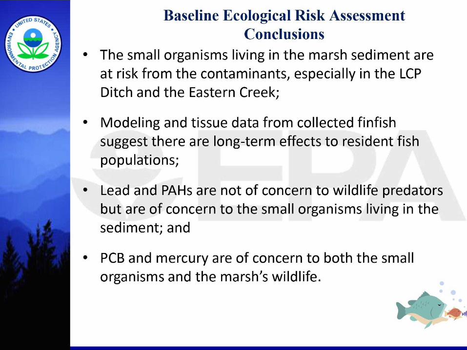
Baseline Eeologieal Risk Assessment Conelusions
The small organisms living in the marsh sediment are at risk from the contaminants, especially in the LCP Ditch and the Eastern Creek;
Modeling and tissue data from collected finfish suggest there are long-term effects to resident fish populations;
Lead and PAHs are not of concern to wildlife predators but are of concern to the small organisms living in the sediment; and
PCB and mercury are of concern to both the small organisms and the marsh's wildlife.
• •

Baseline Eeologieal Risk Assessment Conelusions (eontinued)
Summary of Risks to Wildlife Receptors
Assessment Endpoints
Diamondback terrapin
Clapper rail
Redwing blackbird
Green heron
Marsh rabbit
Raccoon
River otter
COCs
None
MeHg
MeHg
MeHg
Aroelor 1268
Aroelor 1268
Aroelor 1268
Maximum Maximum NOAEL LOAEL Areas of Concern
< 1
3.0
1.0
10.6
4.8
4.9
3.9
<1
1.0
0.3
3.5
0.5
0.5
0.4
None
Domain 1
Eastern Creek, LCP Diteh, Domain 1
Eastern Creek, LCP Diteh, Domains 1.3
Eastern Creek, LCP Ditch
Eastern Creek, LCP Diteh
Domains 2, 3,4

Remedial Action Objectives Reduce releases of hazardous substances from the smaller contaminated creeks to Purvis Creek; Reduce contaminant exposures to fish-eating birds and mammals in the marsh; Reduce risks from contaminated sediment to bottom-living organisms; Reduce finfish exposures from ingestion of contaminated prey; Prevent human exposure to contaminants, through ingestion of finfish and shellfish contaminated above protective levels; and Restore surface water quality.

FEASIBILITY STUDY Identify remediation technologies to cleanup contaminants in the marsh sediment; Screen and evaluate these technologies; Where appropriate, combine technologies into remedial alternatives; and Perform a detailed evaluation on the remedial alternatives
22

Feasibility Study Alternatives Retained for
LCP Chemicals Marsh
Alternative 1: No Action; Alternative 2: Sediment Removal of 48 aeres; Alternative 3: Sediment Removal, Capping and Thin-Cover Plaeement for the 48 aeres; Alternative 4: Sediment Removal of 18 aeres; Alternative 5: Sediment Removal, Capping and Thin-Cover Plaeement for 18 aeres; and Alternative 6: Sediment Removal, Capping and Thin-Cover Plaeement for 23 aeres.

Evaluation Criteria for Superfund Remedial Alternatives
1. Overall Protectiveness of Human Health and the Environment
2. Compliance with ARARs
3. Short-term Effectiveness
4. Long-term Effectiveness and Permanence 5. Reduction of Toxicity, Mobility, or Volume of Contaminants through Treatment 6. Implementability
7. Cost
8. State/Support Agency Acceptance
9. Community Acceptance

Hydraulic Dredging Advantages: • May result in least uneertainty
about long-tem effeetiveness of eleanup, through removal of eontaminants from marsh;
• Minimize uneertainty with predietions of eap stability and potential for future exposure and transport of contaminants;
• May reduce risks more quickly and achieve objectives faster.
Disadvantages:
• Implementation and effeetiveness may be impaired by narrowness of creeks;
• Reeontamination through re-suspension and settling;
• Significant levels of local traffic to ship offsite;
• Disruptive to the marsh ecosystem.
25

&
Conceptual Illustration Of Environmental Dredging And Processes
Release
Release (Water)

In-Situ Capping
Advantages: • Quickly reduces exposure to
fish and biota and, unlike dredging, requires less infrastructure for material handling;
• Potential for contaminant re-suspension and dispersion of contaminated sediment is reduced;
• No contaminated sediment is transported on trucks through community.
Disadvantages: • Contaminants remain in
environment where they could become exposed if cap is disturbed or if contaminants significantly move through cap.
Geotexde-
Geo^id
Water Column
Sand
Contaminated Sediment
A. Eagle Harbor, WA
Water Column
Contaminated Sediment
B. Sheboygan, Wl
Water Column
Sand
Gravel
Contaminated Sediment
C. Convair Lagoon, CA
>-36*
24'Min.
1Z
Source: Mo<fified from U.S. EPA 189Sd

Photo 2.
Hydraulic placement of a subaqueous cap with a spreader barge
28

Thin-Layer Placement
Advantages: • Accelerates natural
recovery by adding a thin layer of clean sediment over contaminated sediment;
• Most effective after high risk sediment areas have been remediated;
Disadvantages: • Limited long-term
demonstrated durability due to more recent usage with limited long-term monitoring data available, to date.
29

No Action
30

Alternative 2: Sediment dredging of 153,000 cubic yards over 48 acres (average depth of 18 inches), clean backfill, institutional controls and long-term monitoring. Cost: $64.8 million, time to complete: 3-to-4 years
Legend Alternative 2: 48 Acres
Dredge All (48 acres) 1 iOU1 Boundary I I Creek/Domain Boundary I 1OU3 Boundary
0U1 Boundary Sour^* Glynn County UOAR Datd. 2007

Alternative 3 Sediment dredging of 27,000 cubic yards over 9 acres, clean backfill, 16 acres of capping and 23 acres of thin-cover placement, institutional controls and long-term monitoring. Cost: $38.7 million, time to complete: 3-to-4 years
Legend
Alternative 3: 48 Acres 1^1 Dredge (9 acres)
Cap (16 acres) Thin Cover - 6 in ( 23 acres)
I I 0U1 Boundary ^ Creek/Domain BourxJary
|__| 0U3 Boundary
Glynn County IXIAR Data. 2007. 32

Alternative 4 Sediment dredging of 57,000 cubic yards over 18 acres, clean backfilling, institutional controls and long-term monitoring. Cost: $34.1 million, time to complete: 2 years.
Legend
Alternative 4: 18 Acres Dredge All (18 acres)
1 1QU1 Boundary I I Creek/Domain Bour»dary
IOU3 Boundary
0U1 Bouidaiy Source: Glynn County LIDAR Data. 2007. 33

Alternative 5 Sediment dredging of 22,000 cubic yards over 7 acres, clean backfill, 3 acres of capping and 8 acres of thin-cover placement. Institutional controls and long-term monitoring. Cost: $25.0 million, time to complete: 2 years
Legend AJternative 6: 18 Acres
Dredge ( 7 acres) Cap (3 acres) Thin Cover - 6 in (8 acres)
I I QU1 BourKJary ] Creek/Domain Boundary ] OU3 BourKJary
<$>
OU1 Boundaiy Sowce: Olynn Couny UOAR Data. 2007.

Alternative 6 Sediment dredging of 22,000 cubic yards over 7 acres, clean backfill, 6 acres of capping and 11 acres of thin-cover placement. Institutional controls and long-term monitoring. Cost: $28.6 million, time to complete: 2 years
Legend Alternative 6: 24 Acres
Dredge ( 7 acres) Cap ( 6 acres) Thin Cover - 6 In (11 acres)
|OU1 Boundary Creek/Domain Boundary
] OU3 Boundary
0U1 Boundary Sctne: Glynn CounQr UOAR Data. 2007.
35

EPA's Preferred Alternative for the LCP Chemicals Marsh: Alternative 6
Dredging of seven acres (22,000 CY) of the LCP Ditch and Eastern Creek to a target depth of 18 inches and backfill with 12 inches of clean material; Capping of 6 acres (14,000 CY) of the Domain 3 Creek and Purvis Creek South; Thin cover placement on 11 acres (13,000 CY) of the Dillon Duck, Domain lAand Domain 2; Long-term monitoring, including biological monitoring; and Institutional Controls. Georgia EPD supports this alternative.
36

Clean-Up Levels (CUL)
COC Proposed SWAC CDLs Proposed Benthic CULs (mg/kg) 1 (mg/kg)2
Mercury 2 11 Aroclor 1268 3 16 Lead NA 177 PAHs NA 4
NA - Not applicable because lean and PAHs only affect the benthic organisms. 1- Surface weighted average concentration, which provide for protection of human health, 2 - Not-to-exceed concentration for protection of benthic organisms.
37
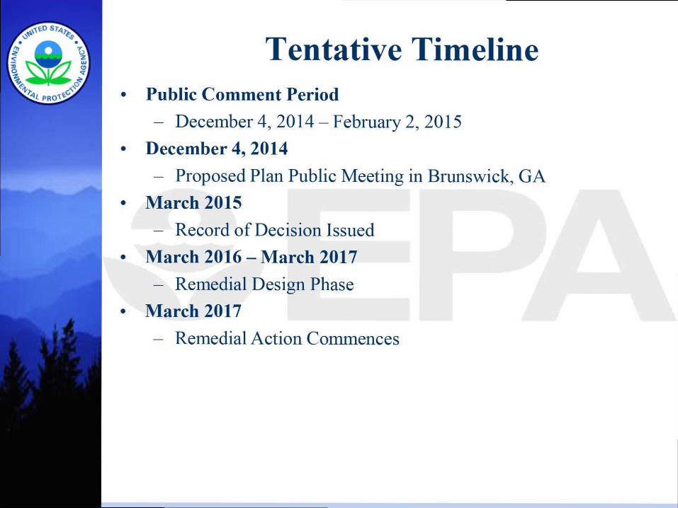
Tentative Timeline Public Comment Period - December 4, 2014-February 2, 2015
December 4, 2014 - Proposed Plan Public Meeting in Brunswick, GA
March 2015 - Record of Decision Issued
March 2016 — March 2017 - Remedial Design Phase
March 2017 - Remedial Action Commences
A

Contact Information Galo Jackson Remedial Project Manager US EPA, Region 4 61 Forsyth Street, S.W. Atlanta, Georgia 30303
s ,-^3pa.qov 404-562-8937
Angela Miller Community Involvement Coordinator US EPA, Region 4 61 Forsyth Street, S.W. Atlanta, Georgia 30303
404-562-8561
Sharon Thoms, PhD Risk Assessor US EPA, Region 4 61 Forsyth Street, S.W. Atlanta, Georgia 30303 .,, G, T: [email protected] 404-562-8666
Jim McNamara, Unit Coordinator Department of Natural Resources GA Environmental Protection Division Floyd Towers East, Ste. 1054 2 Martin Luther King Jr. Dr., SE Atlanta, GA 30334-0900 iim mcnama- Unr.state.qa.us 404-656-7802


![Health Consultation CHemicals 10-2...health consultation for Linden Chemical and Plastics (LCP Chemicals), Brunswick, Georgia . in August 1994 [1].](https://static.fdocuments.net/doc/165x107/5b00b32e7f8b9a54578d09ec/health-consultation-chemicals-10-2health-consultation-for-linden-chemical-and.jpg)