Latitude and Longitude Lines - Portland State University · Latitude Longitude Latitude and...
1
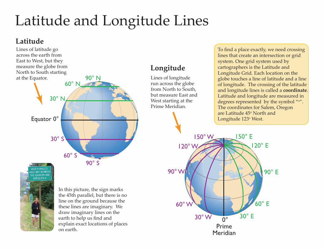
0° Prime Meridian 30° W 60° W 90° W 120° W 150° W 30° E 60° E 90° E 120° E 150° E Equator 0° 30° N 60° N 90° N 30° S 60° S 90° S In this picture, the sign marks the 45th parallel, but there is no line on the ground because the these lines are imaginary. We draw imaginary lines on the earth to help us find and explain exact locations of places on earth. Lines of latitude go across the earth from East to West, but they measure the globe from North to South starting at the Equator. Lines of longitude run across the globe from North to South, but measure East and West starting at the Prime Meridian. Latitude Longitude Latitude and Longitude Lines To find a place exactly, we need crossing lines that create an intersection or grid system. One grid system used by cartographers is the Latitude and Longitude Grid. Each location on the globe touches a line of latitude and a line of longitude. The crossing of the latitude and longitude lines is called a coordinate. Latitude and longitude are measured in degrees represented by the symbol “ o ”. The coordinates for Salem, Oregon are Latitude 45 o North and Longitude 123 o West.
Transcript of Latitude and Longitude Lines - Portland State University · Latitude Longitude Latitude and...
0°Prime
Meridian
30° W
60° W
90° W
120° W 150° W
30° E
60° E
90° E
120° E 150° E
Equator 0°
30° N
60° N90° N
30° S
60° S90° S
In this picture, the sign marks the 45th parallel, but there is no line on the ground because the these lines are imaginary. We draw imaginary lines on the earth to help us find and explain exact locations of places on earth.
Lines of latitude go across the earth from East to West, but they measure the globe from North to South starting at the Equator. Lines of longitude
run across the globe from North to South, but measure East and West starting at the Prime Meridian.
Latitude
Longitude
Latitude and Longitude Lines
To find a place exactly, we need crossing lines that create an intersection or grid system. One grid system used by cartographers is the Latitude and Longitude Grid. Each location on the globe touches a line of latitude and a line of longitude. The crossing of the latitude and longitude lines is called a coordinate. Latitude and longitude are measured in degrees represented by the symbol “o”. The coordinates for Salem, Oregon are Latitude 45o North and Longitude 123o West.