Laser Scanning SOQ.PDF
22
AS-BUILT SERVICES
-
Upload
venugopal-raju -
Category
Documents
-
view
103 -
download
0
Transcript of Laser Scanning SOQ.PDF

AS-BUILT SERVICES

MAGNASOFT OVERVIEW
Magnasoft is a focused geospatial and 3D laser scan data processing services
Company with innovative offerings having strategic partnerships with industry leaders
Magnasoft’s leveraging technology, domain knowledge & robust work planning
methodology deliver high quality data to our worldwide clients
Employ our intelligent domain knowledge to position ourselves as a leading 3D Laser
scan service company to exceed our client expectations on innovation and high quality
of data delivery
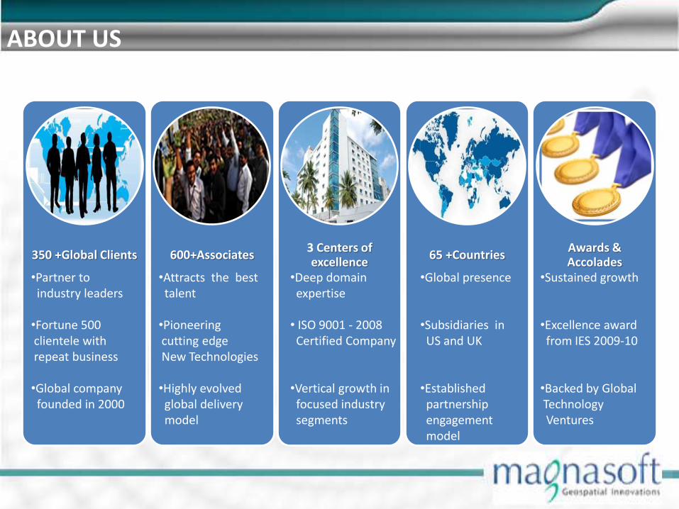
350 +Global Clients
600+Associates
3 Centers of excellence
65 +Countries
Awards & Accolades
•Partner to industry leaders •Fortune 500 clientele with repeat business •Global company founded in 2000
•Attracts the best talent •Pioneering cutting edge New Technologies •Highly evolved global delivery model
•Deep domain expertise • ISO 9001 - 2008 Certified Company •Vertical growth in focused industry segments
•Global presence •Subsidiaries in US and UK •Established partnership engagement model
•Sustained growth
•Excellence award from IES 2009-10 •Backed by Global Technology Ventures
ABOUT US
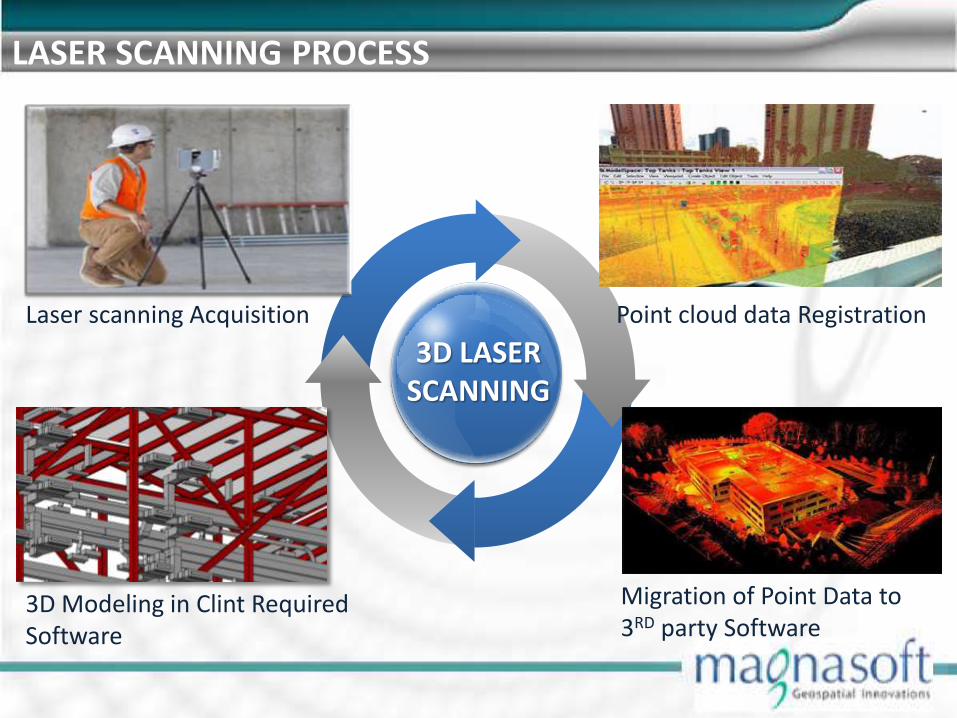
LASER SCANNING PROCESS
3D LASER SCANNING
Laser scanning Acquisition
Migration of Point Data to 3RD party Software
Point cloud data Registration
3D Modeling in Clint Required Software

AS-BUILT SERVICE FOR PROCESS INDUSTRIES
Offering a complete range of As-Built 3D modelling services for structures, equipment,
HVAC, piping, electrical and instrumentation
As-Built 3D models from existing and using industry standard Plant modeling systems
such as AutoCAD, Revit, CADWorx, PDMS & Microstation
Creating Spool Drawings ,BOM from Pipes and steel works

OIL & GAS 3D MODEL POINT CLOUD
POINT CLOUD 3D MODEL

PDMS– PRIMITIVE MODELING
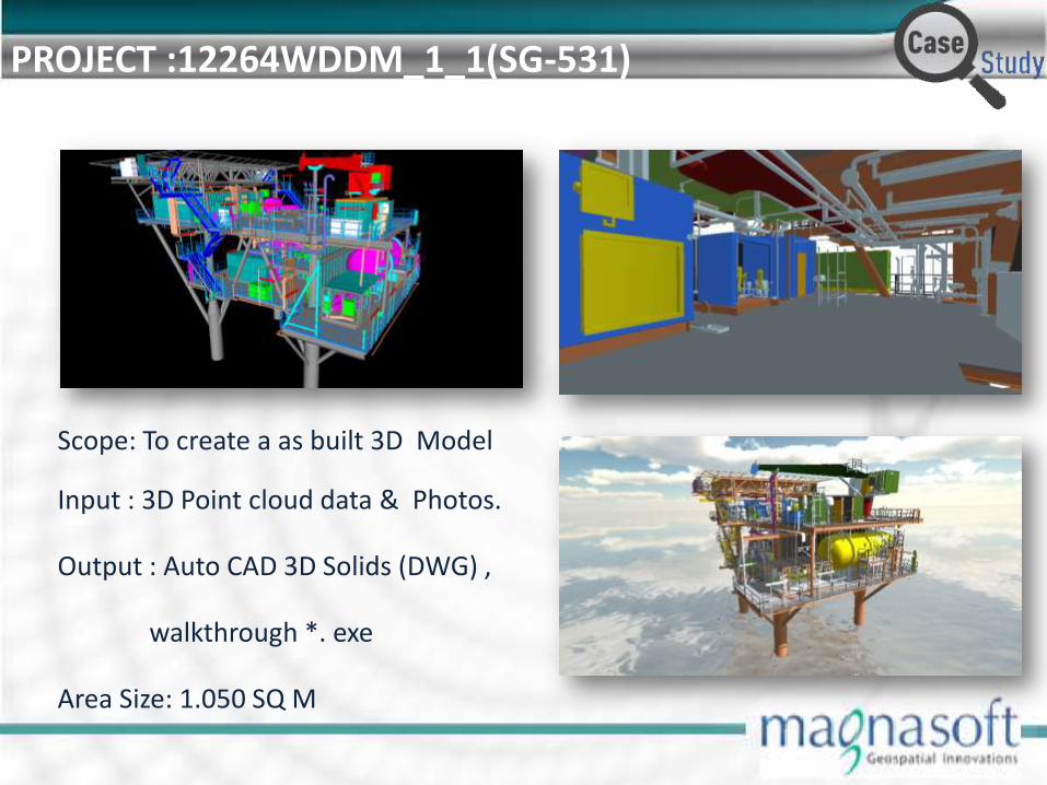
PROJECT :12264WDDM_1_1(SG-531)
Scope: To create a as built 3D Model
Input : 3D Point cloud data & Photos.
Output : Auto CAD 3D Solids (DWG) ,
walkthrough *. exe
Area Size: 1.050 SQ M

PROJECT : NINIAN SOUTH DECK
Scope: To create a As-Built 3D Model
Input : 3D Point cloud data & Photos.
Output : PDMS (*.txt)
Area Size: 11,400 SQ M
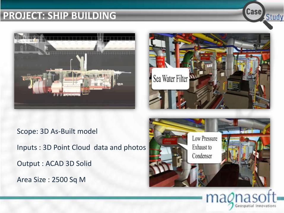
PROJECT: SHIP BUILDING
Scope: 3D As-Built model
Inputs : 3D Point Cloud data and photos
Output : ACAD 3D Solid
Area Size : 2500 Sq M

BIM MODELING POINT CLOUD 3D MODEL
3D MODEL POINT CLOUD

AIRPORT MODELLING
From terminal renovations to cracks and other irregularities on runway surfaces, can measure and document existing conditions at airports, minimizing impacts
In an airport construction project, designers are able to detect clash problems with MEP systems. Conflicts are resolved early in the design process, reducing rework costs during the actual construction

BIM FACILITY MANAGEMENT
Facility management supports decision making, planning and execution of activities
on assets.
By providing a structured framework for the creation, collation and exchange of
information about assets, BIM supports effective facility management.
However, to enable this BIM must provide information covering the whole life cycle
of assets.

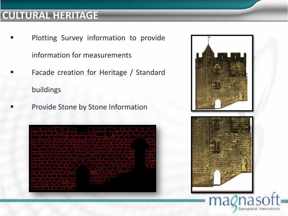
CULTURAL HERITAGE
Plotting Survey information to provide
information for measurements
Facade creation for Heritage / Standard
buildings
Provide Stone by Stone Information

AIRPORT BAGGAGE
Scope: To create a 3D as built Model
Input : 3D Point cloud data & Photos.
Output : 3D Revit Model
Area Size: 27000Sq Mts.

PROJECT:GHS SCHOOL
Scope: To create a 3D as built Model
Input : 3D Point cloud data & Photos.
Output : 3D Revit Model
Area Size: 37000Sq Mts.

PROJECT:ELEMENTARY SCHOOL
Scope: To create a 3D As-Built Model
Input : 3D Point cloud data & Photos.
Output : 3D Revit Model
Area Size: 6000Sq Mts.

PROJECT:3D TUNNEL MODELLING
• Scope: To create a 3D wall/roof Surface.
• Input : 3D Point cloud data & Photos.
• Output : 3D Dwg File.
• Area Size: 3000 Mts.

RISKS
Manual measurements are slow Inaccurate and incomplete
information Location of piping and
equipment Active plant hazards cause
material exposure
DELIVERABLES
Plant model Architectural, structural, MEP models
• For regulatory submissions • For coordination and / or clash detection analysis • For visualization • For cost estimation
Schedule (material, time etc) and phasing problem As-built model Data for facility management
BENEFITS
Lower design costs. Reduce the project design time Fast and accurate data capture. Completeness of survey. Reduced need for site re-visits. Increased safety.

PROJECT SPECS
Creation of Pipes, Structures
Creation of Supports, Architecture
Creation of Electrical Equipment
Creation of Machineries
SERVICES RENDERED Modelling of
Pipes and Structures
Architectural Elements Like Walls, Doors and Windows
Equipment Like Machines and Pumps
Electrical Equipment Like Panel Boards, Cable tray, Conduits.
Generation of Vertical & Horizontal Sections
OUTPUT
Dwg/Dgn Files COE .MAC ( PDMS )/RVT/3DPDF
PROJECT EXPERIENCE
INPUT
Point cloud Data from
Leica P20, C10, C5, HDS6200, HDS7000, HDS8800 and HDS8400
Faro Focus 3D, LS 880
Riegl VZ-400, VZ-1000, VZ-6000, VZ-4000 3D Riegl Z210i
Trimble TX5
Photos - Reference of other features

INDIA Head Office: Magnasoft Consulting India (P) Ltd. Global Village Special Economic Zone, Bangalore, India.
USA Office Magnasoft Spatial Services Inc. 2696, S. Colorado Blvd., #580, Denver, CO 80222, USA.
Delivery Centers: Magnasoft Consulting India (P) Ltd. Global Village Special Economic Zone, Bangalore, India. Tel: +91 (80) 4903-7444 Magnasoft Consulting India (P) Ltd. No 1559/1560, 3rd Floor, Race Course Road, Opp Mission Hospital Hassan- 573 201
UK Office: Magnasoft Europe Ltd. 28 Britton Street, London ECIM 5UE
THANK YOU