Laramide Orogeny Tectonic - msu.edumichal76/classstudyguides/GEO407_FinalExam.pdf · Laramide...
18
Laramide Orogeny ‐ Major Tectonic event that formed the Rocky Mountains. ‐Occurred 70‐40 million y BP ‐Occurred in the interior of the North American Plate. ‐Occurred 1,000 miles from the nearest subduction zone! ‐Laramide uplifts are topographically high areas. ‐Cause: DEBATED ‐ Centainly related to ongoing convergence/subduction of the ‘Oceanic Farallan Plate’ and possibly other oceanic plates off the coast. I ‐‐‐‐‐‐‐‐‐‐‐‐‐‐‐‐‐‐‐1,000 miles‐‐‐‐‐‐‐‐‐‐‐‐‐‐‐I Ancient Plate Boundary
Transcript of Laramide Orogeny Tectonic - msu.edumichal76/classstudyguides/GEO407_FinalExam.pdf · Laramide...

Laramide Orogeny ‐ Major Tectonic event that formed the Rocky Mountains. ‐Occurred 70‐40 million y BP ‐Occurred in the interior of the North American Plate. ‐Occurred 1,000 miles from the nearest subduction zone!
‐Laramide uplifts are topographically high areas. ‐Cause: DEBATED ‐ Centainly related to ongoing convergence/subduction of the ‘Oceanic Farallan Plate’ and possibly other oceanic plates off the coast.
I ‐‐‐‐‐‐‐‐‐‐‐‐‐‐‐‐‐‐‐1,000 miles‐‐‐‐‐‐‐‐‐‐‐‐‐‐‐I
Ancient Plate Boundary

Nevadan Orogeny (170 Million) ‐Farallon Plate = Steeper Subduction Sevier Orogeny (100 Million) Laramide Orogeny (70‐40 Million) ‐Farallon Plate = Shallower Subduction (No one knows why!) ‐Black Hills, SD eastern extent ‐Mountain building in Colorado, etc.
Black Hills Granite, igneous intrusion that poped up through a sedimentary cap during the Laramide Orogeny (70‐40 Million) Eastern most extent of Rocky Mountain building.
REGIONS of the ROCKYS
Canadian Rockies : 100 km. wide (narrow), steep, mostly “sedimentary rocks”, that has been thrust up. ‐Mountain Front (Continuous) Middle/Central Rockies : wider, more dispersed Mountain ranges separated by large areas of High Plains (Big Horn Basin, Wyoming Basin) Southern Rockies : (Colorado / New Mexico) “Front Range” – marks eastern edge ‐53 peaks over 14,000 ft. in Colorado!

75‐40 Million y BP (Laramide Orogeny) Crystalline Rock “UPLIFTED” 34‐10 Million y BP (Cascadian Orogeny) “Rocky Mountain Erosion Surface” forms Crystalline Rock buried by its own eroded sediments. Extended the HIGH PLAINS to present day Utah, Wyoming, and Idaho. 10 Million “UPLIFT EVENT” Eroded sediments are removed – transported toward the Great Plains Evidence for Buried Mountains = Eroded Sediments in the High/Great Plains Laramie, WY – local left over buried sediments ‐Gang Plank Further to the east = Sediments (geographically higher)
Basins – Formed by the erosion of the High Plains (was once a continuous surface). High Plains – stratified sands (granite/quartz), carried by streams (Platte, Missouri, Arkansas)

Spanish P
Formed vWest & Ea ‐Cry ‐Pro Before75 Stratified 75‐25 MilBatholith 25 MillionErosion –
Jemez L Raton‐Cla ‐ Clo ‐You Migrationover a Ho
Peaks, South
ia Volcanism ast Spanish Pystalline; Igneoduced Radial
Million y BP Sandstone (d
lion y BP and Radial D
n y BP ‐ NOW sediments on
RADIAL D
Lineament
ayton Volcaniosest active voungest in field
n of the Northt Spot.
hern Colorad
eak ous Rock l Dikes
dep. ‐ shallow
Dikes form
n Great Plains
DIKES
t
ic Field olcanic to MI d (9‐10 Million
h American Pl
do
w sea)
s
n y BP)
late
SSPANISH PEAAKS

Gl
pr
pr
Bu
Pi
ALPINE
Source: H + No
Orograph
laciation
re‐Bull Lake
re‐Bull Lake
ull Lake
nedale
GLACIERS
igh County (Mormally 300 ft ‐doesn’t n
hic Effect
A
5
3
1
1
S
Mountains; “Ct. thick, due teed thickness
Age Range*
00,000‐700,0
00,000 to 500
30,000 to 300
2,000‐23,000
Cirques”) to continued s like contine
000
0,000
0,000
0
movement ental glaciers
Oxygstage
14 an
8 and
6 (an
2
gen‐isotopee
nd 16
d 12
nd 8)
Mc
P
p
Il
L
Mid‐continencorrelation
Pre‐Illinoisan
pre‐Illinoisan
llinoisan
Late Wisconsi
t
n

Powell Terrace – down cutting during an interglacial (less sediment) Cody Terrace – lower terrace, formed after the Powell Terrace. Shoshone River – coarse sediment, builds terraces.
Powerhouse Section, Baniff NP, Canada
Thicker ice produces a more linear stone fabric! Glaciated Not Glaciated Glaciated Not Glaciated

Colorado Plateau
‐Parts of Wyoming, Utah, Colorado, Arizonia, and New Mexico. ‐Mongollon Rim (Escarpment) ‐ Southern Colorado Plateau Mongollon Rim (below) ‐ Uplifted, Horizontal Rocks Colorado Plateau – thick crust, which all was lifted up. ‐ Uplifted in the last 10 Million Years
25‐ 10 Million y BP 10 Million y BP
Hypothesized Mantle Plume or Up Welling raised the boundary between the Sierra Nevada and the Basin and Range. 10 Million y BP, the Colorado Plateau was also uplifted. Because of the thick crust the whole region was uplifted, instead of succumbing to faulting.

Shiprock, New Mexico ‐ Volcanic Neck with Radial Dikes ‐ Radial Dikes – olivine rich magma (deep within mantle). ‐ A lot of erosion has taken place!
San Francisco Volcanic Field ‐Active 6 Million y BP in Arizona ‐600 “Basalt Cinder Cones” ‐ Low Viscosity (rapid/fluid) ‐Sunset Crater ‐ Cinder Cone = 1 event, Quick!, small (< 1,000 ft.), Spray lava bombs/flows.
Structural Controls (Differential Erosion; Different Erosion Rates) Red Rocks = Permian Period Rocks (298 – 252 million y BP) ‐ elevated levels of oxygen in the atmosphere (heavily oxidized) ‐ Long record of sedimentary rocks (horizontal structure) ‐ Upper Mesozoic Period = shallow interior sea (easy to trace)
Monument Upwarp ‐LARGE, BROAD, Gentle Anticline, SE Utah ‐ Uplifting, followed by Jointing, followed by Erosion, followed by Differential Erosion. ‐Cap Rocks (Resistant SANDSTONE) protecting (erodible SHALE).

Grand C
330‐530 M‐Mississip 550 Millio‐Coastal S
“LARGE G 2 Billion y‐Crystallin
HEA
Canyon (S
Million y BP ppi Delta
on y BP Setting (Dune
GAP”
y BP ne Rocks
VY RAIN EVE
till a “YOU
Field)
ENTS (RARE),
UNG STREA
FLUSH MATE
AM” in Dav
ERIAL OUT OF
isian Thero
F THE VALLEY
oy)
Y

Canyon De Chelly, NE Arizona & Mesa Verde, SW Colorado
Overlying Sandstones let infiltrating water penetrate to the underlying Shale. Dissolved Salts created NICHE – People lived in there. The dating of RAT MITTENS (14C ‐ Radiocarbon) allowed researchers to see when/why people left! ‐Juniper Trees there 1,000 y BP ‐Indians cut all the trees down. ‐Climate warms!!! ‐Juniper not able to grow back.
Arroyos ‐Stream systems characterized by steep canyon walls and flat “sandy” basin floors. +Major periods of cutting – 2,000‐700 y BP (WARMING)! +Recently between 1865‐1915 (LANDUSE CHANGES – GRAZING)! FACTORS Climate Change (el nino, la nina) Internal Adjustments (base level changes, uplifting?) Land Change (Grazing) Cutting & Filling events.

Invasion of Tamarisk (SALT CEDAR) Highly invasive!!!!
‐Loves wet/sandy sites (produces a lot of seeds)
1942
2000
‐Less discharge on the system ‐Deeper channel, less width ‐Sediment deposits near vegetation
Basin & Range Extensional Faulting (Normal Faults)

Playa – Old Lake Bed, Pleistocene in age (Glacial Times; Pluvial Lake) ‐Wetter Climates (Southerly Jet Stream) DUNES! ‐Found in Grabens, accumulations of salts (evaporated) Pediment‐ plained bedrock surface, exposed at ground level. ‐Backwasting
Alluvial Fan‐ Fluvial fan shaped depositional features. ‐Distrubutary channels across the landscape surface ‐Located on the Pediment surface ‐Most extensive in arid/semi arid regioins ‐ Often along mountain fronts ‐Erosion/Depositon ‐Streams primary transport system ‐Grow outward/Conical shape Bajada – entrenchment/coalesce of Alluvial Fans.
‐Larger Drainage Basin = Larger Fan ‐Smaller Drainage Basin = Smaller Fan Bajada

Dating AOSL Datin‐Streams ‐USE GREA ‐LIGHT SE‐DARK SED ‐Des
The
Evidenc +WINE GLDowncuttUplift – M
+FAULTED +FAULTED
Fau
Alluvial Fang (turbidity) maAT CAUTION!
DIMENTS = YDIMENTS = Osert Pavemen
use of Deser
ce for Rapi
LASS CANYONting – StreamMountains aro
D LAKE SEDIM
D ALLUVIAL F
ulted Alluvial
ans
ay not ZERO o!
Young Old, manganesnt, clays blow
t Pavement f
id/Recent
N m/Canyon ound the cany
MENTS
FANS
l Fans/Toes
out the sand
se/iron) w in.
or dating = 14
Uplift alon
yon
grain.
4C – Radiocarb
ng Fault Bl
bon. Decomp
locks W
F
posed bacteria
Wine Glass Ca
Faulted Lake
a in the rinds
anyon
Sediments
.

Desert Pavement (EOLIAN) ‐Coarse, Angular, COMPACT! ‐OLD THEORY: Sand blew away. ‐NEW MODEL: Sand blows in, rain event deposits sands below rocks, evaporation of water in the sand causes the sand to expand/contract, which moves the rocks upward.
Sand River Plane / Columbia Plateau Type of Volcanoes; Shield Volcanoes – Broad, Gentle Slope, Large Cinder Cones – Small, One Event, Fast Composite Volcanoes – Explosive, Large Eruption, Smaller than Shield Volcanoes
SHIELD VOLCANO CINDER CONE COMPOSITE VOLCANO
SNAKE RIVER PLAIN – associated with the Yellowstone Hot Spot. ‐Over 16 Million years old (Hot Spot Migrated; toward the SW, North American Plate Movement)
‐Many Shield Volcanoes (various sizes, liquid lava; low viscosity)

Pearlette Ash (Lava Creek) – From the Yellowstone Caldera (600,000 y BP)
Columbia Plateau (SE Washington / NE Oregon) ‐Created from the subduction of the Juan de Fuca Plate. ‐17‐13,000 y BP
‐MANY DIKES, highly fluid magmas flowing out of cracks over the landscape.
Columbia River “Basalt” Group (CRBG) +Imnaha Basalt (17.5‐17 Million y BP) 5.5% +Grande Ronde Basalt (17‐15 Million y BP) 87 % +Wanapum Basalt (15.5‐14.5 Million y BP) 6% +Saddle Mountain Basalt (14‐6 Million y BP) 1.5%

Not all lavDifferent Conseque Subseque
Cordille ‐Orographhigh elevawindward Most ReceFRASER G ‐VAS Cor ‐NAS Lau
ScablanJ. Harlan B‐ProposedCatastrop ‐Hig ‐App PAS‐VERY LAR1970’s/80 ‐40 JOTHER CA‐Lake Bon‐Lake Aga‐Lake Sag‐Mars!
va flows depoflow patterns
ent Flow – FLO
nt Flow – NO
eran Ice Sh
hic Effect‐ moations, soon pd slopes.
ent; GLACIATION (SHON STADErdilleran Ice SSSIOU STADEurentide Ice S
nds Bretz (1920’sd Scabland fephic Flood! ghly Criticizedplied UniformST happen NORGE RIPPLES o0’s. Jokulhlaups (ATASTROPHICnneville at Redssiz inaw
osit basalt oves are noticed
OWING on the
OT FLOWING o
heet
oist Pacific airproducing gla
15,000 y BP) E – furthest exSheet. E – furthest exSheet.
) atures were p
mitarianism (POW) on the landsc
(CatastrophicC FLOODS; d Rock Pass, I
er one anothein different r
e original sur
on the origina
r snows in theciers on the
xtent of the
xtent of the
produced fro
Processes in t
cape, found in
c Floods) foun
Idaho
er. regions.
face.
al surface.
e
m a
he
n the
nd!

Cascade‐Step Ang‐30 Millio ‐7 Million‐Major vo‐Formatio ‐Ma ‐Sedimen ‐Wa Oly ‐Cascadesvolcanic s‐Still some‐Surround‐Mount St ‐Hi
es gle Subductioon y BP – early
n y BP MAJORolcanic outpouon of small vogma/Mud bla
tary Prism (Seas also uplifteympic Range
s are deformesediment. e sporadic voding Volcanoet. Helens expigh Viscosity &
on of the Juanly cascade ep
R OUTPOURINurings olcanoes anketed the r
een at the coed and becam
ed remnants
olcanoes (13,5es typically (5plodes the mo& Pressure
n de Fuca Platisode
NGS;
region
ast in the figume the modern
of an earlier
500 ‐ 14,0005,000 – 6,000 ost
te
ure) n
feet high) feet high)
Reconstructing Past Eruptions ‐Looking at Lahars (fast mudflows = glacier melting due to volcanic eruptions). ‐ Old tree bases ‐14C – Radiocarbon trees and counting tree rings ‐Allows researchers to estimate eruptions and tree age.
LAHAR
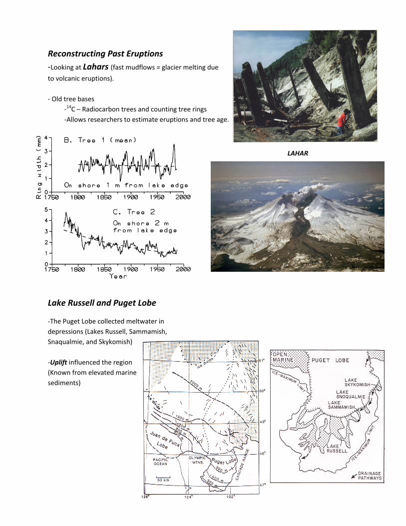
Lake Russell and Puget Lobe
‐The Puget Lobe collected meltwater in depressions (Lakes Russell, Sammamish, Snaqualmie, and Skykomish) ‐Uplift influenced the region (Known from elevated marine sediments)