Landscape regeneration and food security in Northern Lebanon · Akaar region, Northern Lebanon. See...
39
Landscape regeneration and food security in Northern Lebanon An update on project concepts, opportunities and potential 2 nd September 2015
Transcript of Landscape regeneration and food security in Northern Lebanon · Akaar region, Northern Lebanon. See...

Landscape regeneration and
food security in Northern Lebanon
An update on project concepts, opportunities and potential
2nd September 2015

Key Facts – Ouadi Khalid municipality
• On the border with Syria this community hosts 15,000 refugees – equal to the local population.
• Lack of water for agriculture and horticulture makes for minimal food production and insufficient employment opportunities.
• Many refugee and local families can no longer afford sufficient nutritious food.
• Rainfall is reasonable (c. 700mm/year) – the problem is the lack of rainwater retention on hillsides and houses.
• Agricultural production is limited – new, innovative methods and higher value products are needed.

Akaar region, Northern Lebanon. See Beirut in bottom left. Tripoli city on the coast to the North. From Beirut to NE Akaar takes about 2.5 hours by car.

The area visited for this project
Important to note that security is currently good in this area, with significant Lebanese armed forces presence along the Lebanese side. And no conflict in the surrounding Syrian areas. This project proposes and assumes that social tensions in Lebanon can be reduced by increasing economic opportunities and ecological restoration.
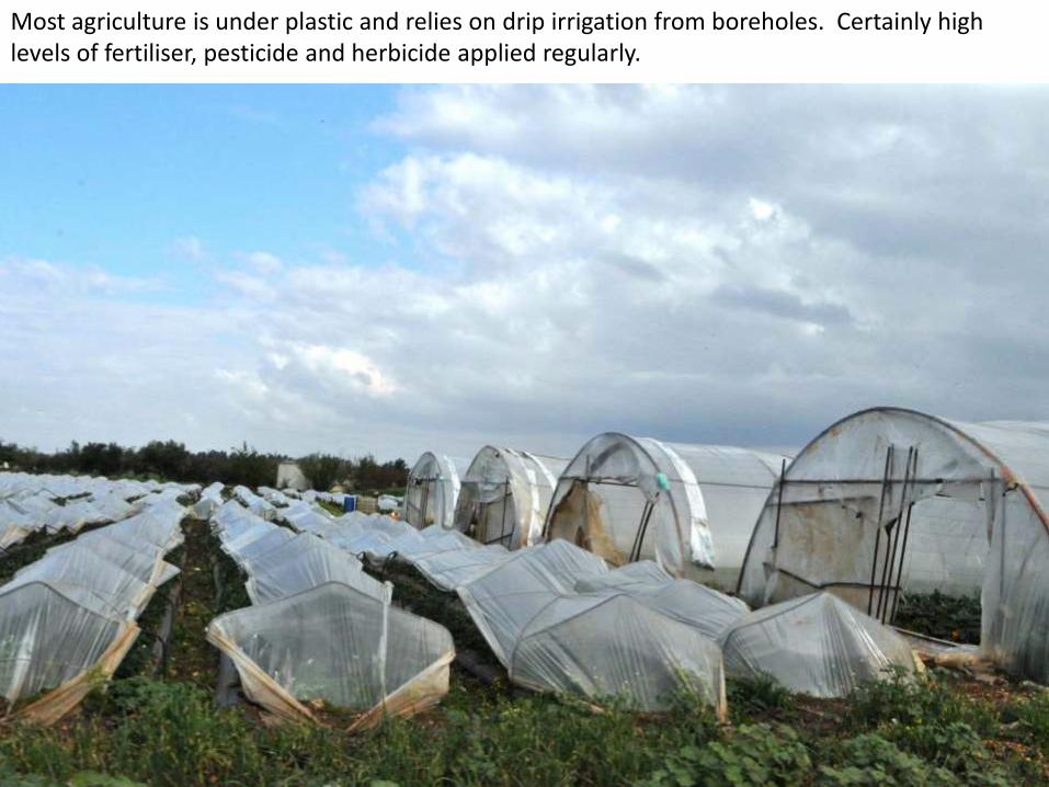
Most agriculture is under plastic and relies on drip irrigation from boreholes. Certainly high levels of fertiliser, pesticide and herbicide applied regularly.
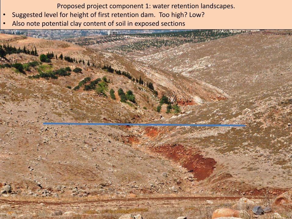
Proposed project component 1: water retention landscapes. • Suggested level for height of first retention dam. Too high? Low? • Also note potential clay content of soil in exposed sections

Potential area for water retention lake. Assume major digging work to remove extensive earth from left and right of river valley to place at the dam end. Rainfall: approx. 700mm / year. Water catchment area above this potential dam extends for between 500m and 1.5km radius.

View to left, showing elevation of hillside / water catchment area. See cows in left of picture for scale, however they are on a raised level, some 3 to 5m above the valley. Suggest swales or crescent swales for individual trees on landscape surround catchment lake

Right view, showing equal rise to the right. With appropriate water – retention features all these hills could be forested within 5 years.

View across top of valley – which descends to the right, out of picture. This land is also part of the water catchment area and will funnel water towards the valley. With appropriate design and planning this whole area could be regenerated with trees and productive species – assuming sheep and goats are kept out.

Ernst Gotsch, pioneer of agro-forestry in Brazil, conducting training on a site that was completely denuded and dry 20 years ago, similar to the previous slide. The learning and evidence generated by projects and experts such as Ernst will be brought to this new programme in Lebanon.

An estimate of the scale of a second dam / water retention lake, brown colour being the dam and road access to the other side. Picture taken in March 2015, hence extensive green cover. This would be only around 200 m lower down that the first dam – probably too close?

Pictures from lower down the valley– taken in March, right, and August, below. Trees on terraces on other side are same as those in previous pictures.

Distance to inhabited areas and potential agricultural areas ranges from 1km to 2km. Impact on pipeline cost to distribute water to agricultural areas?

Angle showing the bottom of the valley, rocky on both sides – which presumably enables extensive water run-off during rains, into the valley floor. A dam here would have to be built using some rock and reinforced concrete structures, and may not be worth the investment.

View from very bottom of valley floor. Distance from here to the top of the valley is
approximate 2km, while the distance to the trees on terraces (in previous pictures) is about 1km

Looking upwards from the valley floor, to give scale of hillside (and water collection potential)

Potential here for low walls to be built from surrounding rocks to around waist height (where the guy in pink is standing) to create a level terrace to hold rainwater when it runs off the hill. Filled with organic material it would retain water far longer than the surrounding landscape, enabling pioneer trees and shrubs to establish, which would create shade and moisture for other plants and productive species.

Young olive trees immediately to the left of the rocky area in previous pictures.. These show the potential of the “rocky and denuded terrain” (from previous slide). These olive trees would be many times more productive if they were planted on a swale, on contour, absorbing all available rainwater.

View from above the rocky valley floor, looking down the valley towards the inhabited areas. The olive trees indicate the potential for additional agro-forestry – especially as these are only rain-fed.

An example of designing swales (ditches on contour) on a topographical map.
And a cross section through of different swale designs

At the bottom of the valley some refugee families have built temporary structures – and in some cases kitchen gardens. Water retention landscapes or dams would directly benefit these people if the water was transported down the valley.

A new road has been built, by the municipality, along the top of this valley. The excavated earth shows the potentially high quality of the soil below. It appears to have a rich loamy consistency, a good balance of sand and clay with some organic material present.

Sewage outflow evident from these houses at top of the hill. A perfect opportunity for a waste-water garden (constructed wetland) which then allowed treated water leaving the wetland to irrigate plants / trees on the lower side of the road, towards the valley floor.

The houses, from previous slide, shown at the top of the hill. In the foreground a terrace could easily be formed, while other ditches on contour (swales) could be built along the hill, catching rainwater and treated sewerage water alike. Trees, shrubs and plants in the swales and terraces would benefit greatly from the residual nutrients available in the waste water. Within 2 years this area could be an example of abundance and productivity.

Many other valleys and hillsides exist within the municipality. All privately owned, making investment potentially complicated – requires more research on shareholding rights, distribution of eventual profit, employment rights, etc.

How swales work, cross section. Fences allow for animal pasture outside this productive area.

How swales are key for stabilising eroded slopes and enabling reforestation.

Reem El-Zhori, from Homs, cooks on gas fires. As the principle source of cooking fuel, this makes up an enormous part of her family’s monthly expenditure. Low-cost biogas systems would be appropriate here. Training and guidance needed initially. Thereafter the trainers can replicate among many other families, local and Syrian alike.

An impressive kitchen garden built by this refugee family under their own steam (no external assistance). With aubergines, corn, onions and peppers it has the potential to save some money from their monthly food expenditure and increase household food security
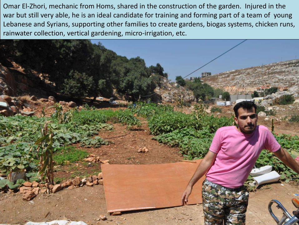
Omar El-Zhori, mechanic from Homs, shared in the construction of the garden. Injured in the war but still very able, he is an ideal candidate for training and forming part of a team of young Lebanese and Syrians, supporting other families to create gardens, biogas systems, chicken runs, rainwater collection, vertical gardening, micro-irrigation, etc.

Discussing gardening matters with local Lebanese family (much scratching of heads), but here the young people were equally keen to join a “Gardens Outreach Team” that could be hired for an initial period, trained and mentored over an 18 month period, until self-reliant.

A large proportion of refugees are children, most of whom have nothing to do. All day. Like kids everywhere they could benefit so much from home gardening, especially considering the traumatic exodus from their homelands. Gardens by children will be part of the programme.
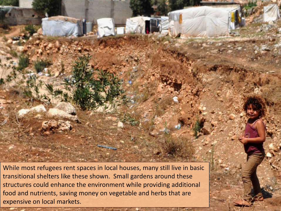
While most refugees rent spaces in local houses, many still live in basic transitional shelters like these shown. Small gardens around these structures could enhance the environment while providing additional food and nutrients, saving money on vegetable and herbs that are expensive on local markets.

After the rains (March). These lands could be highly productive, bringing much needed work to the area, using ecological agriculture techniques that enhance local biodiversity.

Impact Revitalised agricultural economy; Socio-economic stability
Activities & notes
Outcomes • Enhanced food security • Increased livelihood
opportunities
• Effective strategy for large-scale water retention piloted and disseminated
Output 1 Water catchment at storage increased by 400%
• Water retention landscape • Water ditches on contour
Output 2 Agricultural livelihoods opportunities increased by 20%
• Training / mentoring of agro-forestry & ecological agriculture
• Formation of farmer co-operatives • Biogas industry initiated • Innovative honey and fish systems
Output 3 Household food security enhanced • Training / mentoring of intensive organic household gardens
• Composting/ biogas slurry / worms • Vertical gardening • Waste water gardens • Trained outreach team w/ tech support
Output 4 Research and evidence • Partnership with local university • Baseline indicators & evaluation of
results • Publications & dissemination of results
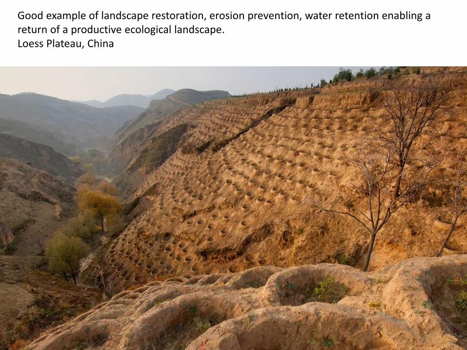
Good example of landscape restoration, erosion prevention, water retention enabling a return of a productive ecological landscape. Loess Plateau, China

Before and After Effective water retention and regeneration project. Loess Plateau, China

Water retention landscape in Tamera, Alentejo, Portugal, where the annual rainfall is less than Northern Lebanon. The change to the surrounding landscape has been remarkable, enabing the planting of thousands of fruit, nut, timber and other trees, creation of horticulture spaces, etc.