
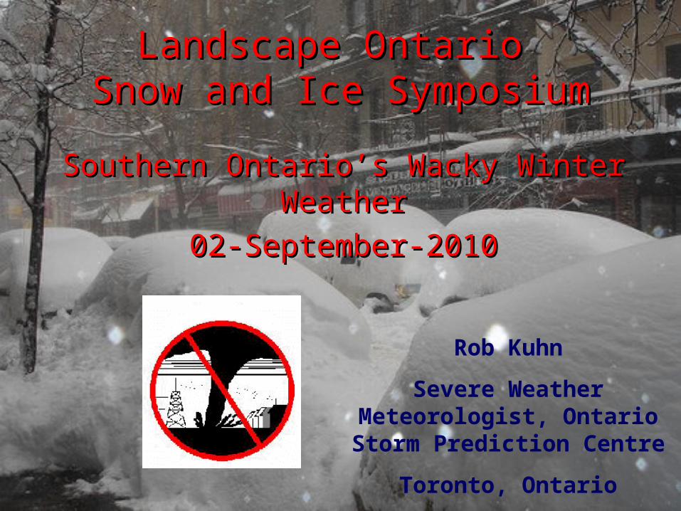
Landscape Ontario Snow and Ice Symposium Southern Ontario’s Wacky Winter Weather 02-September-2010...
68
Landscape Ontario Landscape Ontario Snow and Ice Symposium Snow and Ice Symposium Southern Ontario’s Wacky Winter Southern Ontario’s Wacky Winter Weather Weather 02-September-2010 02-September-2010 Rob Kuhn Severe Weather Meteorologist, Ontario Storm Prediction Centre Toronto, Ontario
-
date post
22-Dec-2015 -
Category
Documents
-
view
217 -
download
2
Transcript of Landscape Ontario Snow and Ice Symposium Southern Ontario’s Wacky Winter Weather 02-September-2010...
Landscape Ontario Landscape Ontario Snow and Ice SymposiumSnow and Ice Symposium
Southern Ontario’s Wacky Winter Southern Ontario’s Wacky Winter WeatherWeather
02-September-201002-September-2010
Rob Kuhn
Severe Weather Meteorologist, Ontario Storm Prediction Centre
Toronto, Ontario
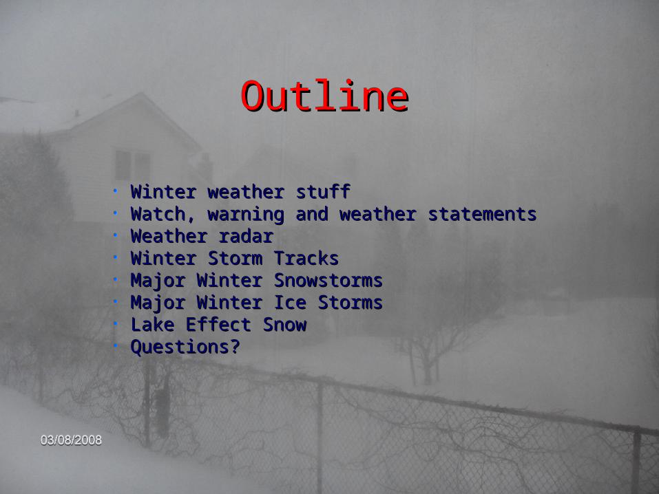
OutlineOutline
• Winter weather stuffWinter weather stuff• Watch, warning and weather statementsWatch, warning and weather statements• Weather radar Weather radar • Winter Storm TracksWinter Storm Tracks• Major Winter SnowstormsMajor Winter Snowstorms• Major Winter Ice StormsMajor Winter Ice Storms• Lake Effect SnowLake Effect Snow• Questions?Questions?

Job Profile and EducationJob Profile and EducationEnvironment CanadaEnvironment Canada
-Ontario Storm Prediction Centre--Ontario Storm Prediction Centre-•Honours BSc (UWO)1984Honours BSc (UWO)1984•MSc Meteorology (U of T) 1987MSc Meteorology (U of T) 1987•Government Operational Meteorology Course 1987-88Government Operational Meteorology Course 1987-88•Internship Winnipeg 1988-1989Internship Winnipeg 1988-1989•Internship Toronto 1989-1990Internship Toronto 1989-1990•Lead/Severe Weather Meteorologist 1995-presentLead/Severe Weather Meteorologist 1995-present•Continuous learning (courses, teaching, R&D)Continuous learning (courses, teaching, R&D)•OutreachOutreach•Shift work 24/7Shift work 24/7
Your income taxes help pay my salary!Your income taxes help pay my salary!

Some Winter Weather StuffSome Winter Weather Stuff
Lake effect snow a major contributer!Lake effect snow a major contributer!
http://www.islandnet.com/~see/weather/graphics/photos/http://www.islandnet.com/~see/weather/graphics/photos/glsnow.gifglsnow.gif

Some Winter Weather Some Winter Weather StuffStuff
Snowfall amounts Southern OntarioSnowfall amounts Southern Ontario(not snowbelts)(not snowbelts)
Average total winter snow … about 100-150 cmAverage total winter snow … about 100-150 cmAverage number of days with snow .. About 65Average number of days with snow .. About 65
Snow Season .. Nov 15 to April 15 Snow Season .. Nov 15 to April 15
Tr-2 cm - 1-3 times a weekTr-2 cm - 1-3 times a week2-10 cm – 2-5 times a month2-10 cm – 2-5 times a month
10-20 cm – 2-4 times per winter10-20 cm – 2-4 times per winter20-30 cm – once every 2-3 years20-30 cm – once every 2-3 yearsClose to 30 cm – January 1999Close to 30 cm – January 1999
40 cm or over – March 07-08, 200840 cm or over – March 07-08, 2008
Biggest Ever – 76 cm Nov 24-25, 1950Biggest Ever – 76 cm Nov 24-25, 1950
Many small snowfalls with drifting Many small snowfalls with drifting snow from lake effect flurriessnow from lake effect flurries

Some Winter Weather Some Winter Weather StuffStuff
Snowfall amounts Southern Ontario SnowbeltsSnowfall amounts Southern Ontario Snowbelts
Average total winter snow … about 200-300 cmAverage total winter snow … about 200-300 cm
Average number of days with snow .. About 90Average number of days with snow .. About 90Snow Season .. Nov 01 to April 15 Snow Season .. Nov 01 to April 15
Tr-2 cm - 3-5 times a weekTr-2 cm - 3-5 times a week2-10 cm – 2-5 times a month2-10 cm – 2-5 times a month
10-30 cm – 5-10 times per winter10-30 cm – 5-10 times per winter30-50 cm – 1 event annually30-50 cm – 1 event annually
50 cm or over – probably 1-2 times each two years50 cm or over – probably 1-2 times each two years
Biggest snows - 200 cm over 2-3 daysBiggest snows - 200 cm over 2-3 days
Many snowfalls with drifting snow Many snowfalls with drifting snow from lake effect flurries and from lake effect flurries and
snowsquallssnowsqualls
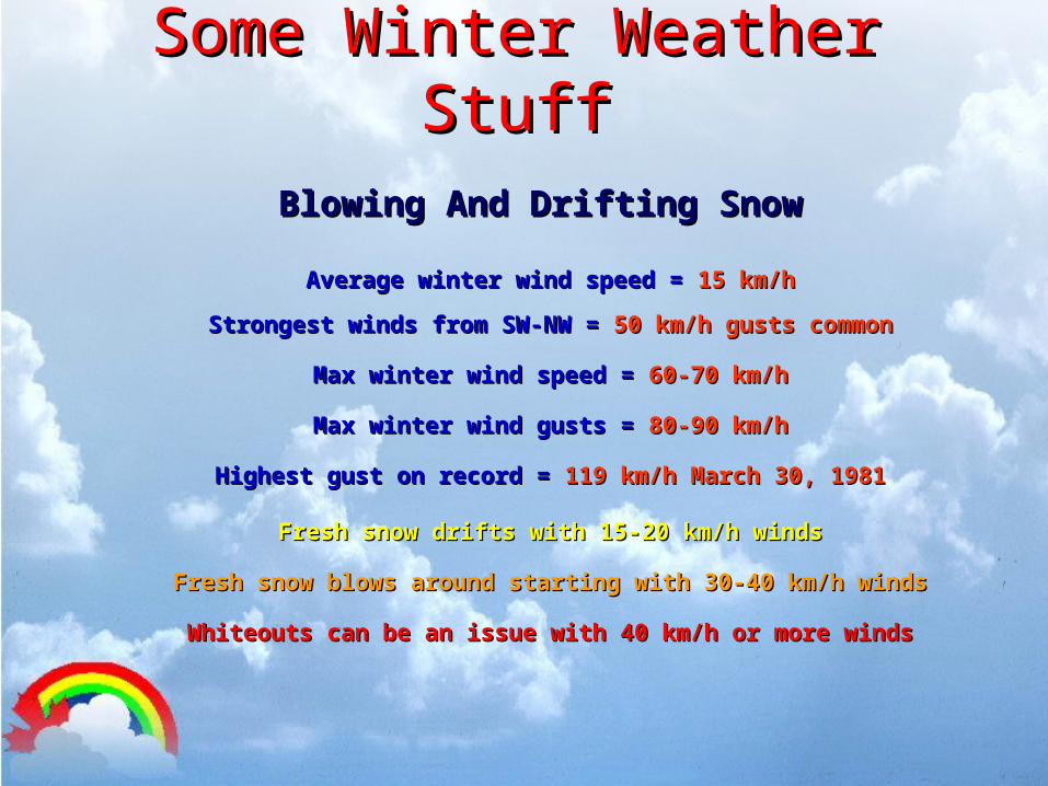
Some Winter Weather Some Winter Weather StuffStuff
Blowing And Drifting Snow Blowing And Drifting Snow
Average winter wind speed = Average winter wind speed = 15 km/h15 km/h
Strongest winds from SW-NW = Strongest winds from SW-NW = 50 km/h gusts common50 km/h gusts common
Max winter wind speed = Max winter wind speed = 60-70 km/h60-70 km/h
Max winter wind gusts = Max winter wind gusts = 80-90 km/h80-90 km/h
Highest gust on record = Highest gust on record = 119 km/h March 30, 1981119 km/h March 30, 1981
Fresh snow drifts with 15-20 km/h windsFresh snow drifts with 15-20 km/h winds
Fresh snow blows around starting with 30-40 km/h windsFresh snow blows around starting with 30-40 km/h winds
Whiteouts can be an issue with 40 km/h or more windsWhiteouts can be an issue with 40 km/h or more winds
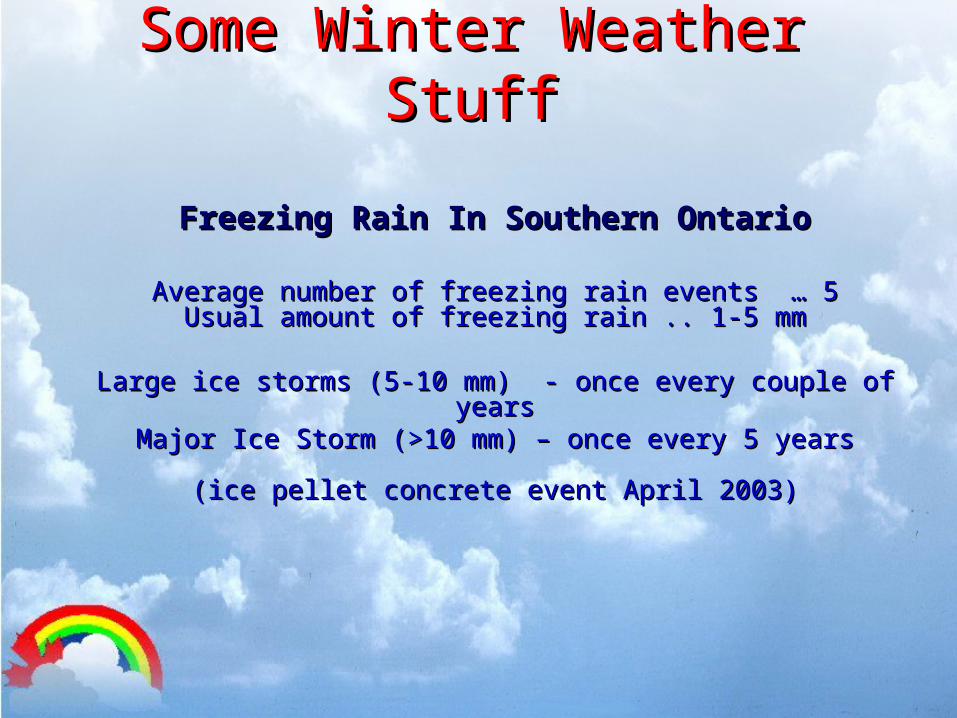
Some Winter Weather Some Winter Weather StuffStuff
Freezing Rain In Southern OntarioFreezing Rain In Southern Ontario
Average number of freezing rain events … 5Average number of freezing rain events … 5Usual amount of freezing rain .. 1-5 mmUsual amount of freezing rain .. 1-5 mm
Large ice storms (5-10 mm) - once every couple of yearsLarge ice storms (5-10 mm) - once every couple of yearsMajor Ice Storm (>10 mm) – once every 5 yearsMajor Ice Storm (>10 mm) – once every 5 years
(ice pellet concrete event April 2003)(ice pellet concrete event April 2003)
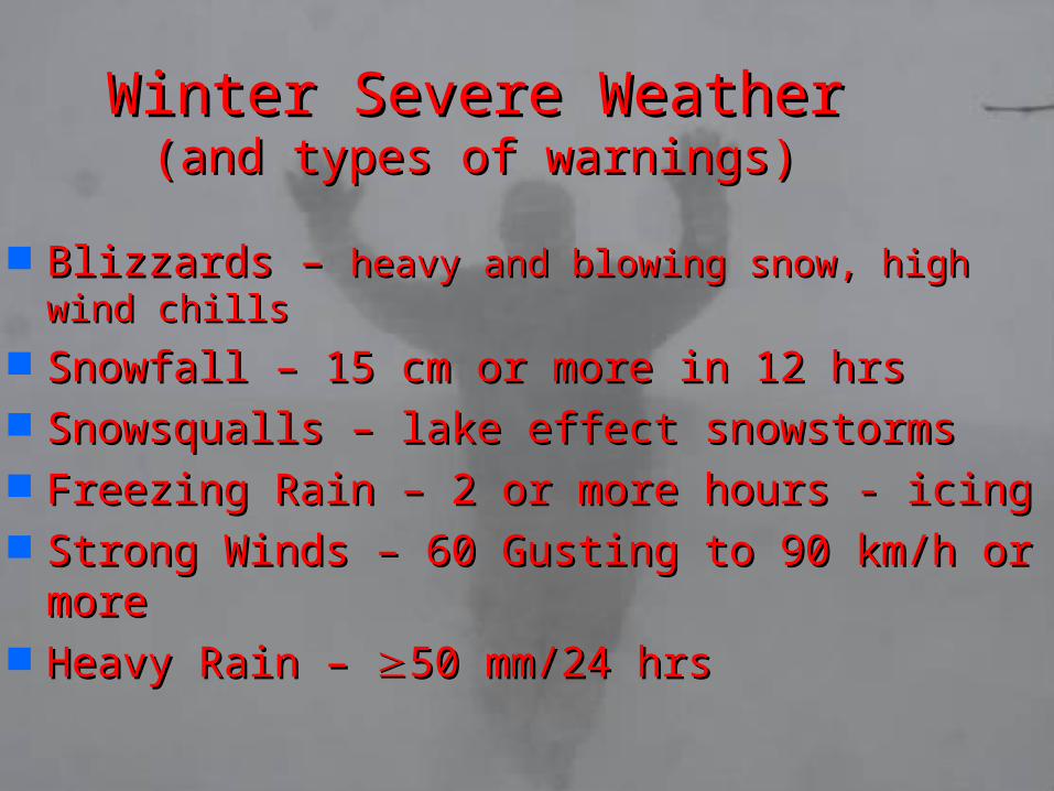
Winter Severe WeatherWinter Severe Weather(and types of warnings)(and types of warnings)
Blizzards – Blizzards – heavy and blowing snow, high wind heavy and blowing snow, high wind chillschills
Snowfall – 15 cm or more in 12 hrsSnowfall – 15 cm or more in 12 hrs Snowsqualls – lake effect snowstormsSnowsqualls – lake effect snowstorms Freezing Rain – 2 or more hours - icingFreezing Rain – 2 or more hours - icing Strong Winds – 60 Gusting to 90 km/h or Strong Winds – 60 Gusting to 90 km/h or
moremore Heavy Rain – Heavy Rain – 50 mm/24 hrs50 mm/24 hrs
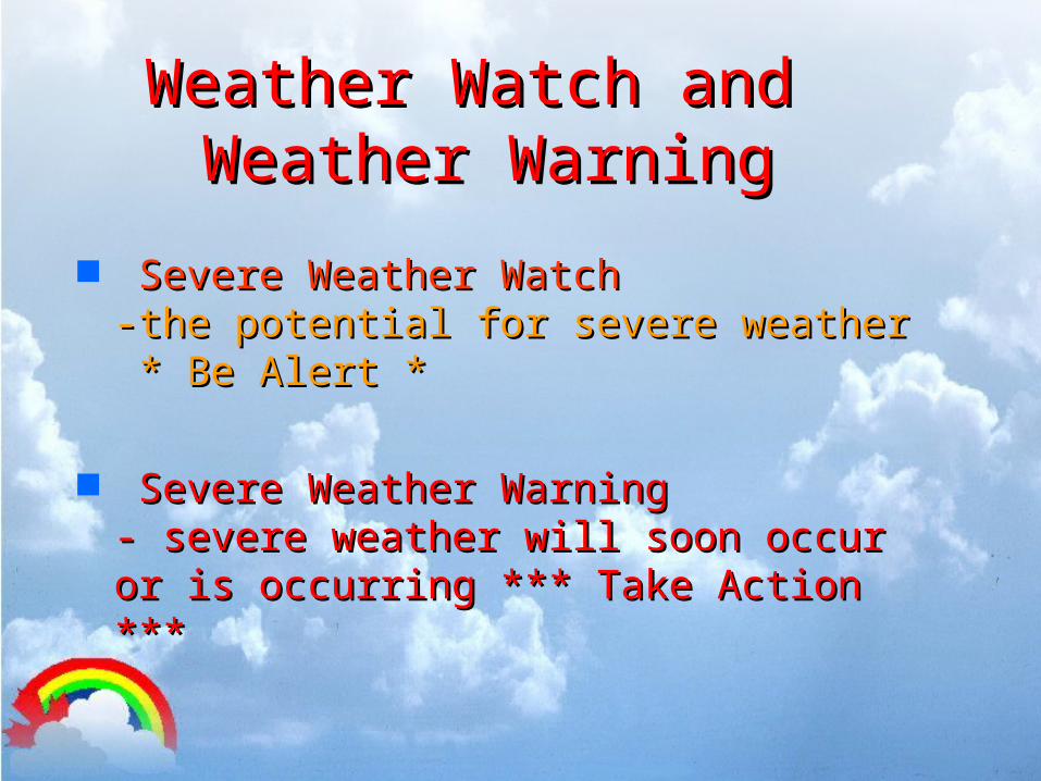
Weather Watch andWeather Watch and Weather Warning Weather Warning
Severe Weather WatchSevere Weather Watch -the potential for severe weather-the potential for severe weather * Be Alert ** Be Alert *
Severe Weather WarningSevere Weather Warning - severe weather will soon occur or - severe weather will soon occur or is occurring *** Take Action ***is occurring *** Take Action ***
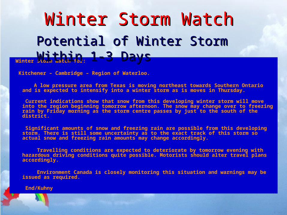
Winter Storm WatchWinter Storm Watch
Winter Storm Watch for:
Kitchener – Cambridge – Region of Waterloo.
A low pressure area from Texas is moving northeast towards Southern Ontario and is expected to intensify into a winter storm as is moves in Thursday.
Current indications show that snow from this developing winter storm will move into the region beginning tomorrow afternoon. The snow may change over to freezing rain by Friday morning as the storm centre passes by just to the south of the district.
Significant amounts of snow and freezing rain are possible from this developing storm. There is still some uncertainty as to the exact track of this storm so actual snow and freezing rain amounts may change accordingly.
Travelling conditions are expected to deteriorate by tomorrow evening with hazardous driving conditions quite possible. Motorists should alter travel plans accordingly.
Environment Canada is closely monitoring this situation and warnings may be issued as required.
End/Kuhny
Potential of Winter Storm Within 1-3 DaysPotential of Winter Storm Within 1-3 Days
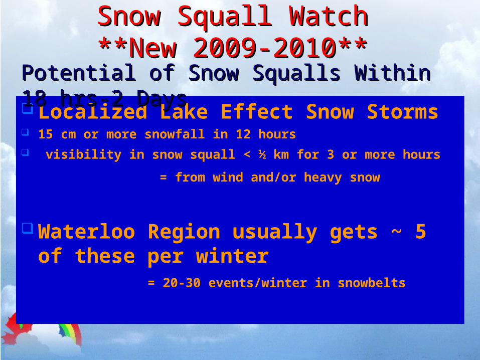
Snow Squall WatchSnow Squall Watch**New 2009-2010****New 2009-2010**
Localized Lake Effect Snow Storms 15 cm or more snowfall in 12 hours visibility in snow squall < ½ km for 3 or more hours
= from wind and/or heavy snow
Waterloo Region usually gets ~ 5 of these per winter = 20-30 events/winter in snowbelts
Potential of Snow Squalls Within 18 hrs-2 DaysPotential of Snow Squalls Within 18 hrs-2 Days
Snow Squall WatchSnow Squall Watch
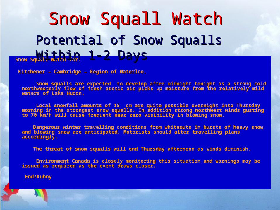
Snow Squall Watch for:
Kitchener – Cambridge – Region of Waterloo.
Snow squalls are expected to develop after midnight tonight as a strong cold northwesterly flow of fresh arctic air picks up moisture from the relatively mild waters of Lake Huron.
Local snowfall amounts of 15 cm are quite possible overnight into Thursday morning in the strongest snow squalls. In addition strong northwest winds gusting to 70 km/h will cause frequent near zero visibility in blowing snow.
Dangerous winter travelling conditions from whiteouts in bursts of heavy
snow and blowing snow are anticipated. Motorists should alter travelling plans accordingly.
The threat of snow squalls will end Thursday afternoon as winds diminish.
Environment Canada is closely monitoring this situation and warnings may be issued as required as the event draws closer.
End/Kuhny
Potential of Snow Squalls Within 1-2 DaysPotential of Snow Squalls Within 1-2 Days
Winter Weather WarningWinter Weather Warning
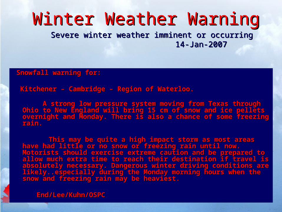
Snowfall warning for:Snowfall warning for:
Kitchener – Cambridge – Region of Waterloo. Kitchener – Cambridge – Region of Waterloo.
A strong low pressure system moving from Texas through A strong low pressure system moving from Texas through Ohio to New England will bring 15 cm of snow and ice pellets Ohio to New England will bring 15 cm of snow and ice pellets overnight and Monday. There is also a chance of some overnight and Monday. There is also a chance of some freezing rain.freezing rain.
This may be quite a high impact storm as most areas have This may be quite a high impact storm as most areas have had little or no snow or freezing rain until now. Motorists had little or no snow or freezing rain until now. Motorists should exercise extreme caution and be prepared to allow should exercise extreme caution and be prepared to allow much extra time to reach their destination if travel is much extra time to reach their destination if travel is absolutely necessary. Dangerous winter driving conditions absolutely necessary. Dangerous winter driving conditions are likely..especially during the Monday morning hours when are likely..especially during the Monday morning hours when the snow and freezing rain may be heaviest. the snow and freezing rain may be heaviest.
End/Lee/Kuhn/OSPCEnd/Lee/Kuhn/OSPC
Severe winter weather imminent or occurring Severe winter weather imminent or occurring 14-Jan-200714-Jan-2007
Special Weather Special Weather StatementStatement
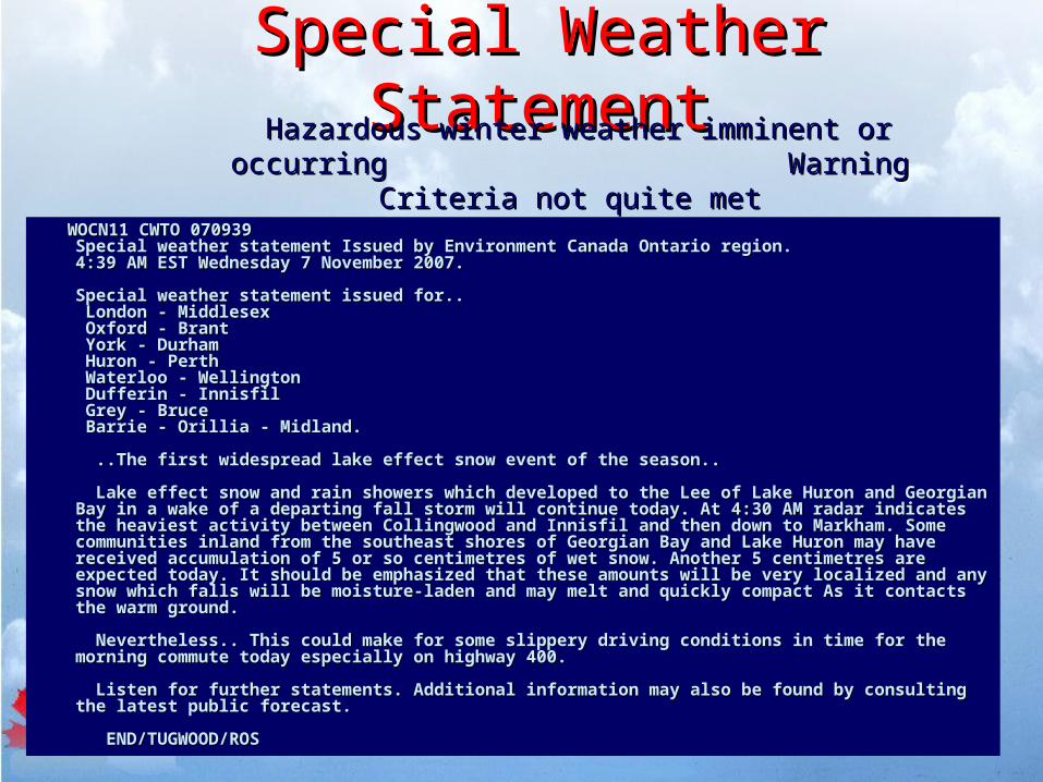
WOCN11 CWTO 070939 WOCN11 CWTO 070939 Special weather statement Issued by Environment Canada Ontario region. Special weather statement Issued by Environment Canada Ontario region. 4:39 AM EST Wednesday 7 November 2007. 4:39 AM EST Wednesday 7 November 2007.
Special weather statement issued for.. Special weather statement issued for.. London - Middlesex London - Middlesex Oxford - Brant Oxford - Brant York - Durham York - Durham Huron - Perth Huron - Perth Waterloo - Wellington Waterloo - Wellington Dufferin - Innisfil Dufferin - Innisfil Grey - Bruce Grey - Bruce Barrie - Orillia - Midland. Barrie - Orillia - Midland.
..The first widespread lake effect snow event of the season.. ..The first widespread lake effect snow event of the season..
Lake effect snow and rain showers which developed to the Lee of Lake Huron and Lake effect snow and rain showers which developed to the Lee of Lake Huron and Georgian Bay in a wake of a departing fall storm will continue today. At 4:30 AM radar Georgian Bay in a wake of a departing fall storm will continue today. At 4:30 AM radar indicates the heaviest activity between Collingwood and Innisfil and then down to indicates the heaviest activity between Collingwood and Innisfil and then down to Markham. Some communities inland from the southeast shores of Georgian Bay and Lake Markham. Some communities inland from the southeast shores of Georgian Bay and Lake Huron may have received accumulation of 5 or so centimetres of wet snow. Another 5 Huron may have received accumulation of 5 or so centimetres of wet snow. Another 5 centimetres are expected today. It should be emphasized that these amounts will be very centimetres are expected today. It should be emphasized that these amounts will be very localized and any snow which falls will be moisture-laden and may melt and quickly localized and any snow which falls will be moisture-laden and may melt and quickly compact As it contacts the warm ground. compact As it contacts the warm ground.
Nevertheless.. This could make for some slippery driving conditions in time for the Nevertheless.. This could make for some slippery driving conditions in time for the morning commute today especially on highway 400. morning commute today especially on highway 400.
Listen for further statements. Additional information may also be found by consulting Listen for further statements. Additional information may also be found by consulting the latest public forecast.the latest public forecast.
END/TUGWOOD/ROS END/TUGWOOD/ROS
Hazardous winter weather imminent or occurring Hazardous winter weather imminent or occurring Warning Criteria not quite met Warning Criteria not quite met
Winter Weather EffectsWinter Weather Effects
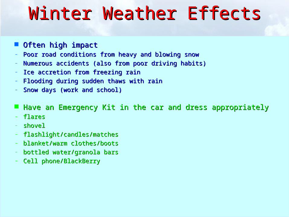
Often high impactOften high impact– Poor road conditions from heavy and blowing snowPoor road conditions from heavy and blowing snow– Numerous accidents (also from poor driving habits)Numerous accidents (also from poor driving habits)– Ice accretion from freezing rainIce accretion from freezing rain– Flooding during sudden thaws with rainFlooding during sudden thaws with rain– Snow days (work and school)Snow days (work and school)
Have an Emergency Kit in the car and dress appropriately Have an Emergency Kit in the car and dress appropriately – flaresflares– shovelshovel– flashlight/candles/matchesflashlight/candles/matches– blanket/warm clothes/bootsblanket/warm clothes/boots– bottled water/granola barsbottled water/granola bars– Cell phone/BlackBerryCell phone/BlackBerry

Weather RadarWeather Radar
Radar transmits beam out Radar transmits beam out horizontallyhorizontally
Receiver at radar station picks up Receiver at radar station picks up some return signal reflected off of some return signal reflected off of rain, snow, hail rain, snow, hail
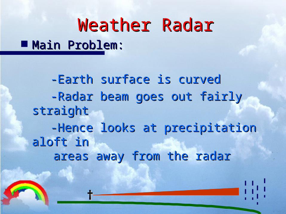
Weather RadarWeather Radar Main Problem:Main Problem:
-Earth surface is curved-Earth surface is curved
-Radar beam goes out fairly -Radar beam goes out fairly straightstraight
-Hence looks at precipitation aloft -Hence looks at precipitation aloft inin areas away from the radar areas away from the radar
††
Weather RadarWeather Radar
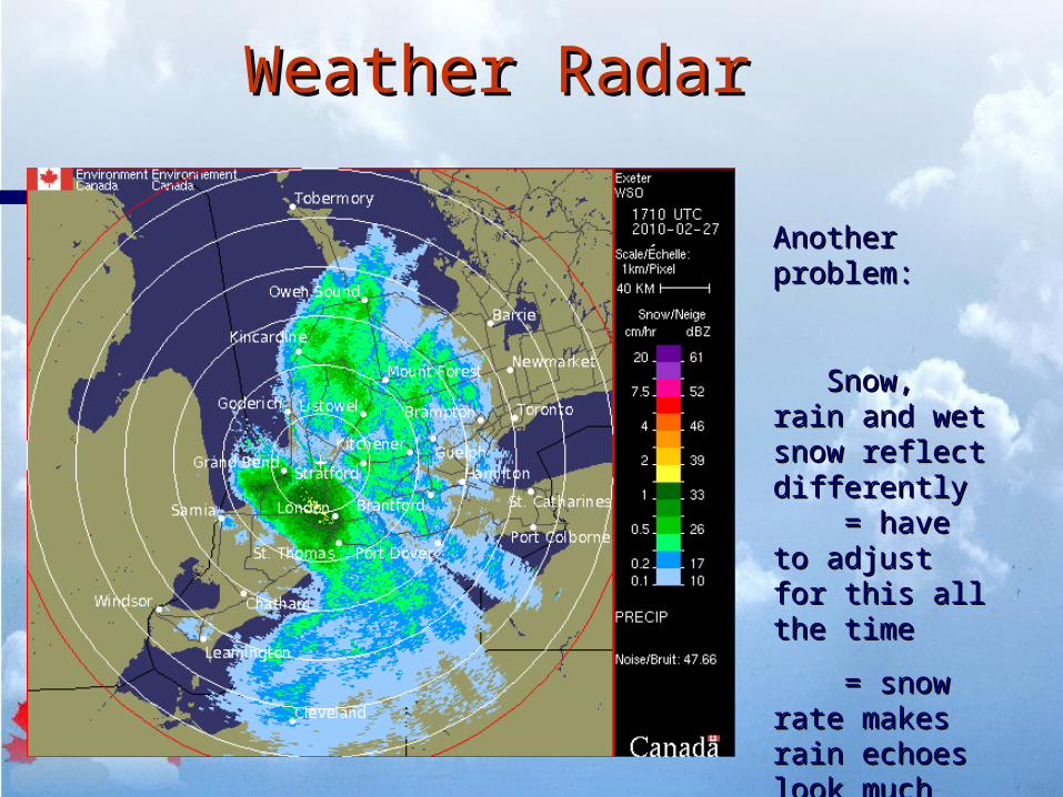
Another problem:Another problem:
Snow, rain and Snow, rain and wet snow reflect wet snow reflect differentlydifferently = have to adjust = have to adjust for this all the timefor this all the time
= snow rate = snow rate makes rain echoes makes rain echoes look much heavierlook much heavier
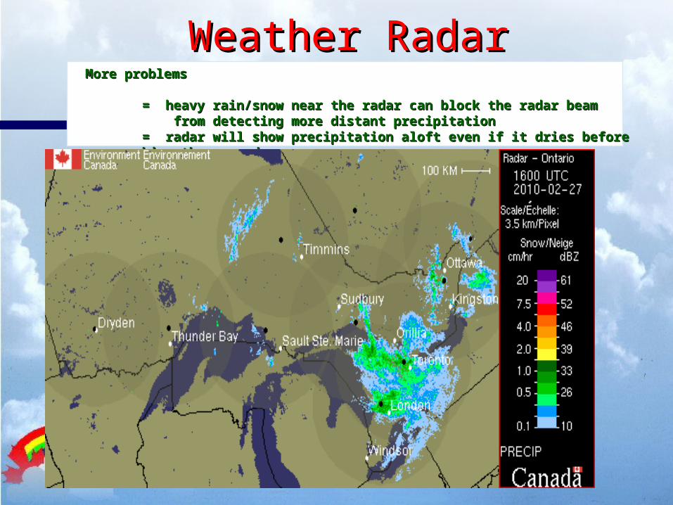
Weather RadarWeather RadarMore problemsMore problems
= heavy rain/snow near the radar can block the radar beam = heavy rain/snow near the radar can block the radar beam from detecting more distant precipitation from detecting more distant precipitation = radar will show precipitation aloft even if it dries before reaching the ground = radar will show precipitation aloft even if it dries before reaching the ground
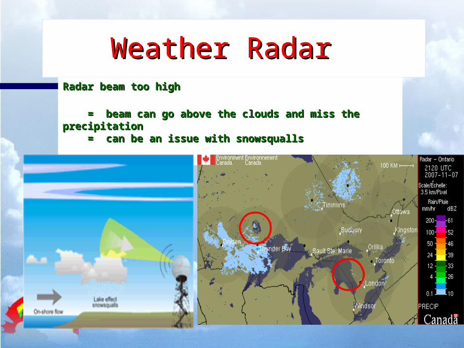
Weather RadarWeather Radar
Radar beam too highRadar beam too high
= beam can go above the clouds and miss the precipitation = beam can go above the clouds and miss the precipitation = can be an issue with snowsqualls = can be an issue with snowsqualls
Weather RadarWeather Radar
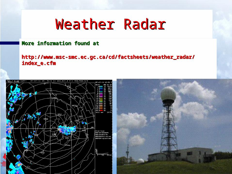
More information found atMore information found at
http://www.msc-smc.ec.gc.ca/cd/factsheets/weather_radar/index_e.cfmhttp://www.msc-smc.ec.gc.ca/cd/factsheets/weather_radar/index_e.cfm
Weather RadarWeather Radar
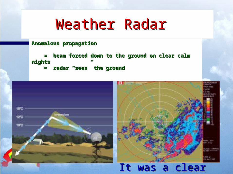
Anomalous propagationAnomalous propagation
= beam forced down to the ground on clear calm nights = beam forced down to the ground on clear calm nights = radar “sees” the ground = radar “sees” the ground
It was a clear night!!It was a clear night!!
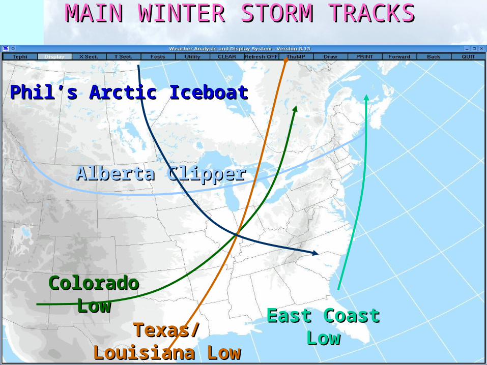
MAIN WINTER STORM TRACKSMAIN WINTER STORM TRACKS
Alberta ClipperAlberta Clipper
Colorado LowColorado Low
Texas/Louisiana Texas/Louisiana LowLow
East Coast LowEast Coast Low
Phil’s Arctic IceboatPhil’s Arctic Iceboat
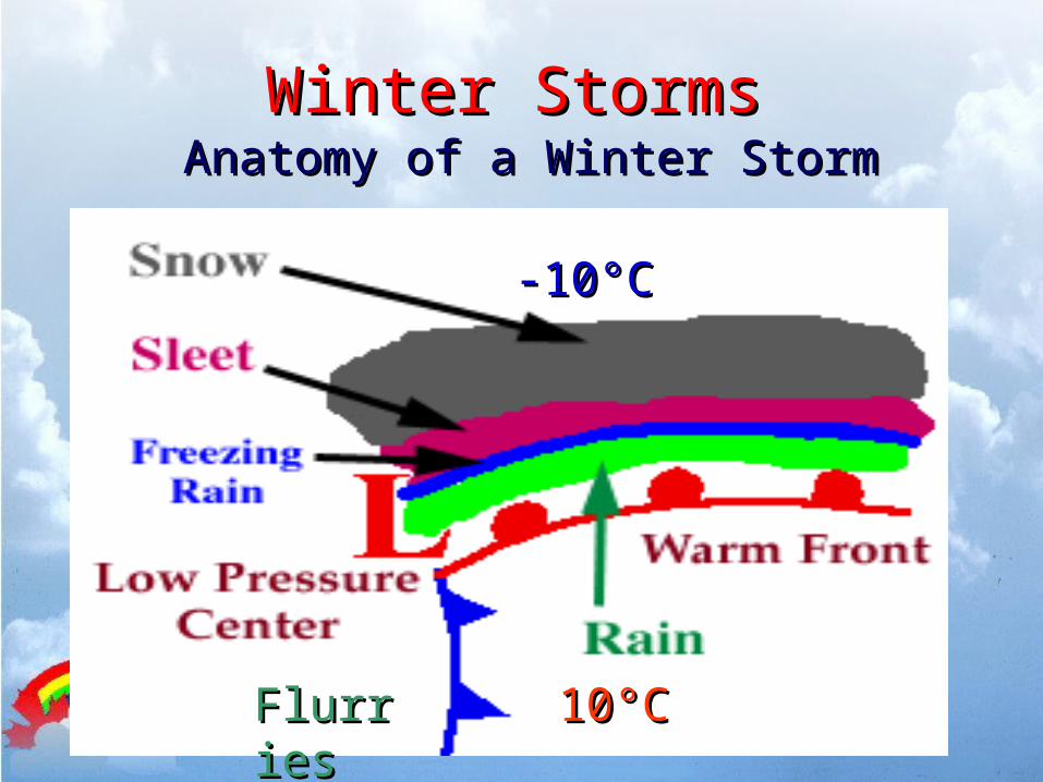
Winter StormsWinter StormsAnatomy of a Winter Storm Anatomy of a Winter Storm
-10-10°C°C
1010°C°CFlurriesFlurries
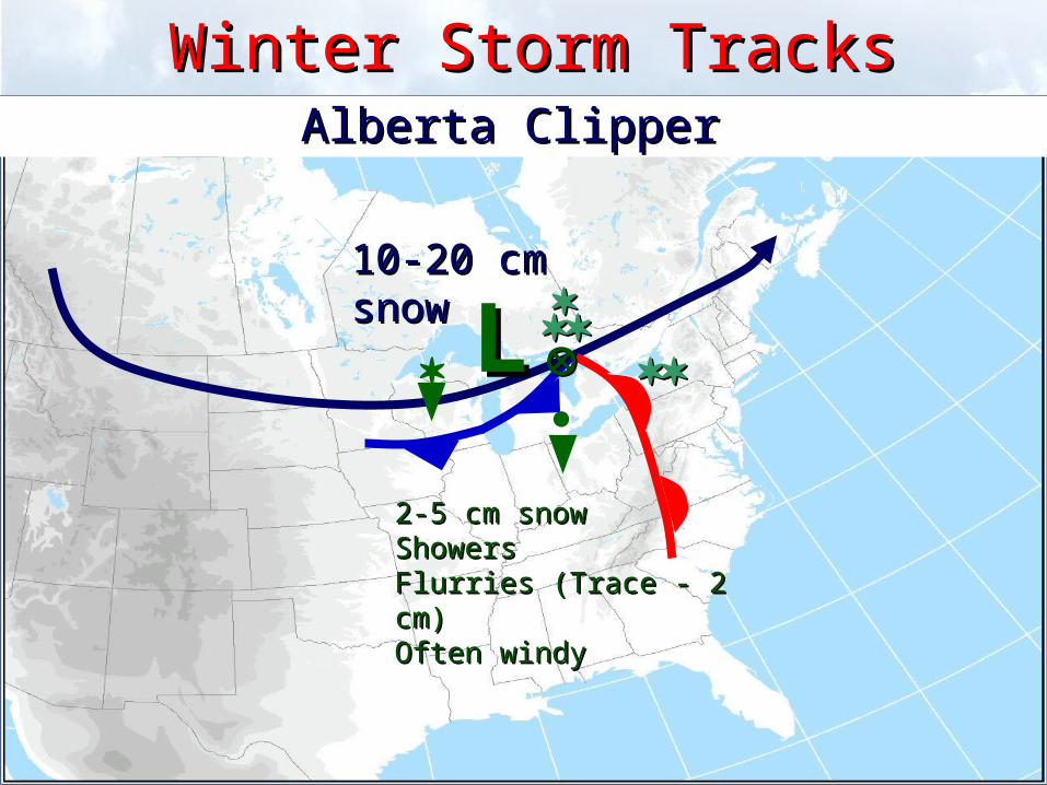
Winter Storm TracksWinter Storm TracksAlberta Clipper Alberta Clipper
10-20 cm snow10-20 cm snow
2-5 cm snow2-5 cm snowShowersShowersFlurries (Trace - 2 cm)Flurries (Trace - 2 cm)Often windy Often windy
LL
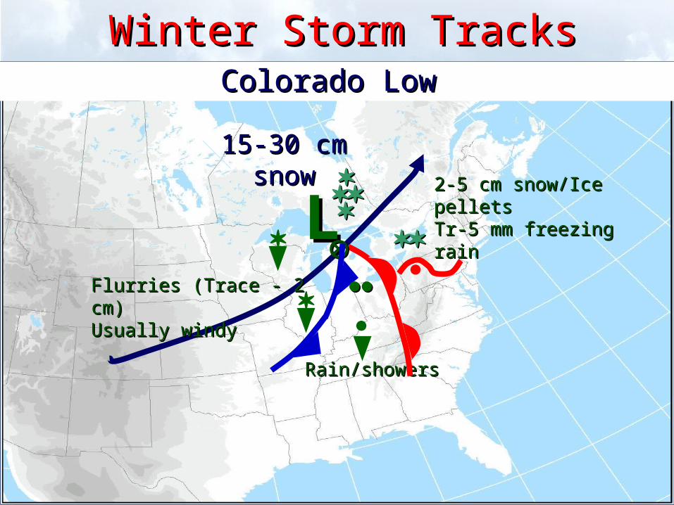
Winter Storm TracksWinter Storm TracksColorado Low Colorado Low
15-30 cm 15-30 cm snowsnow
Rain/showersRain/showers
LL
2-5 cm snow/Ice pellets2-5 cm snow/Ice pelletsTr-5 mm freezing rainTr-5 mm freezing rain
Flurries (Trace - 2 cm)Flurries (Trace - 2 cm)Usually windy Usually windy
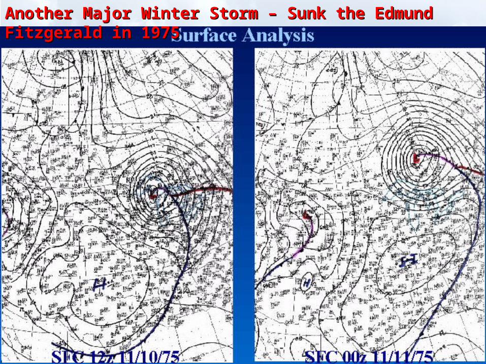
Another Major Winter Storm – Sunk the Edmund Fitzgerald in 1975Another Major Winter Storm – Sunk the Edmund Fitzgerald in 1975
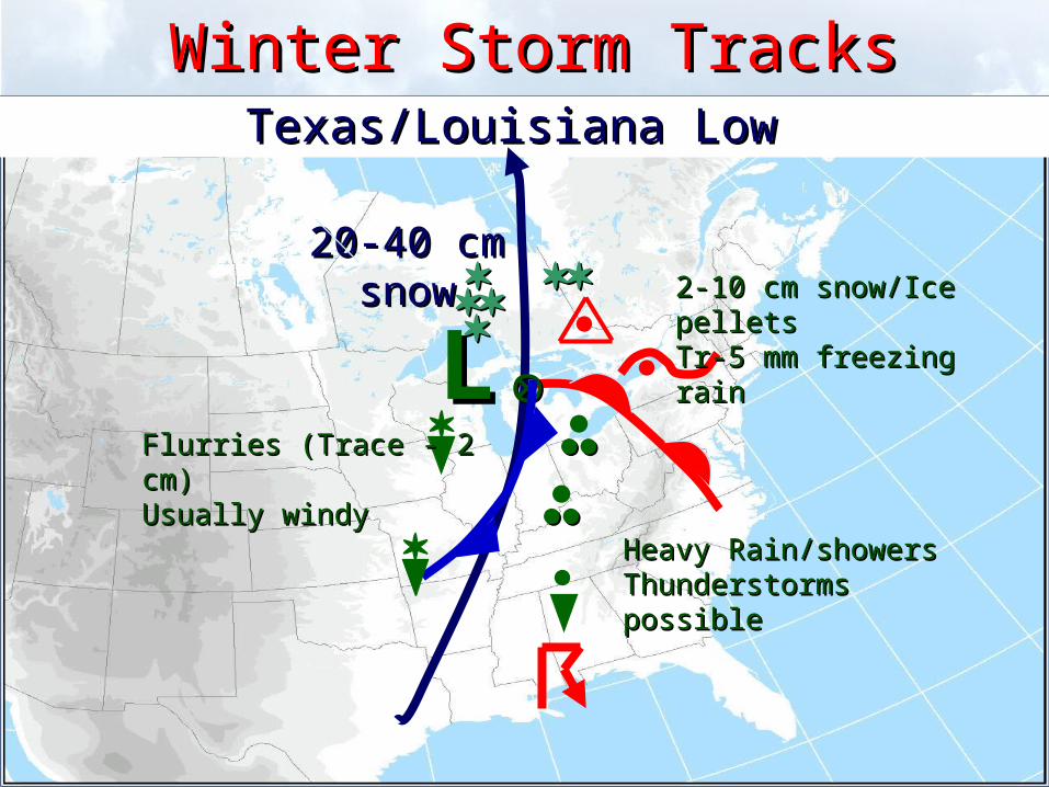
Winter Storm TracksWinter Storm TracksTexas/Louisiana Low Texas/Louisiana Low
20-40 cm 20-40 cm snowsnow
Heavy Rain/showersHeavy Rain/showersThunderstorms possibleThunderstorms possible
LL
2-10 cm snow/Ice pellets2-10 cm snow/Ice pelletsTr-5 mm freezing rainTr-5 mm freezing rain
Flurries (Trace - 2 cm)Flurries (Trace - 2 cm)Usually windy Usually windy
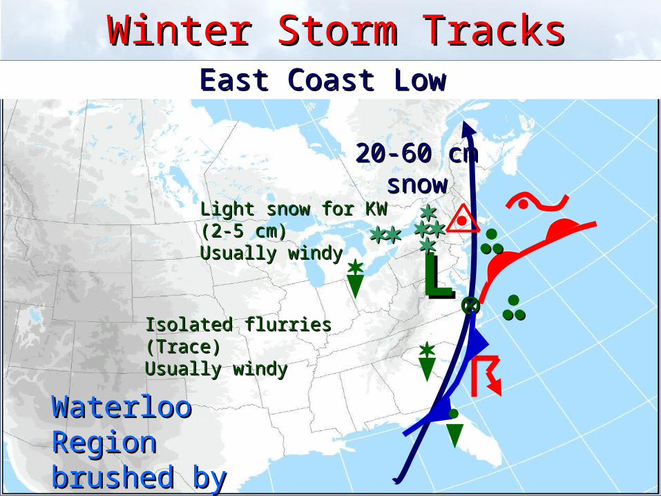
Winter Storm TracksWinter Storm TracksEast Coast Low East Coast Low
20-60 cm 20-60 cm snowsnow
LL
Isolated flurries (Trace)Isolated flurries (Trace)Usually windy Usually windy
Light snow for KW Light snow for KW
(2-5 cm)(2-5 cm)Usually windy Usually windy
Waterloo Region Waterloo Region brushed by these brushed by these stormsstorms
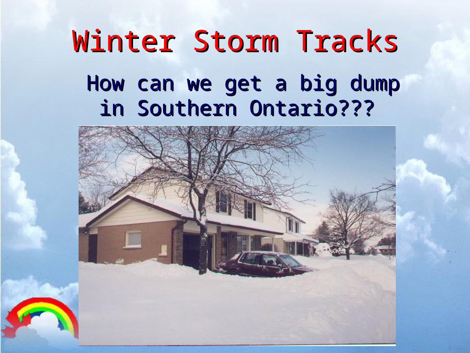
Winter Storm TracksWinter Storm TracksHow can we get a big dump in How can we get a big dump in
Southern Ontario??? Southern Ontario???
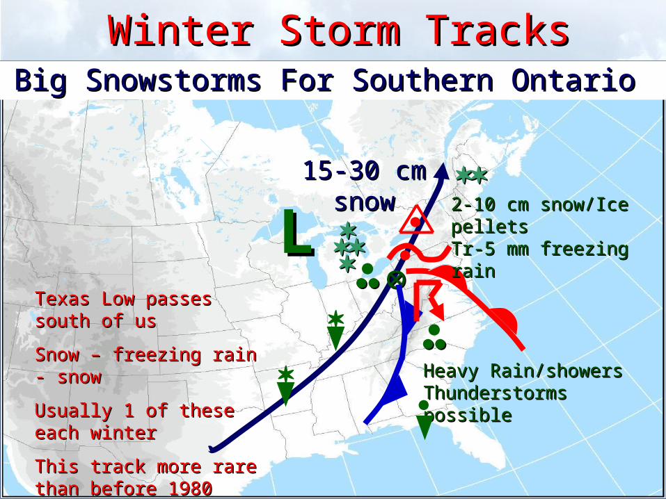
Winter Storm TracksWinter Storm TracksBig Snowstorms For Southern Ontario Big Snowstorms For Southern Ontario
15-30 cm 15-30 cm snowsnow
Heavy Rain/showersHeavy Rain/showersThunderstorms possibleThunderstorms possible
LL
2-10 cm snow/Ice pellets2-10 cm snow/Ice pelletsTr-5 mm freezing rainTr-5 mm freezing rain
Texas Low passes south of usTexas Low passes south of us
Snow – freezing rain - snow Snow – freezing rain - snow
Usually 1 of these each winterUsually 1 of these each winter
This track more rare than This track more rare than before 1980before 1980
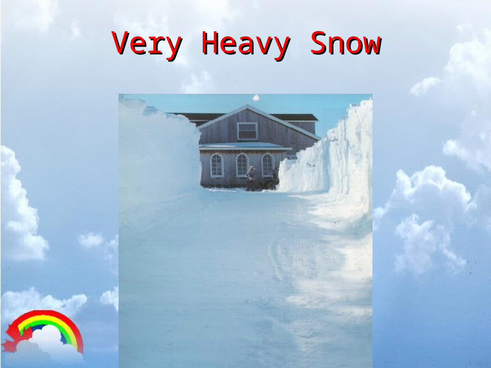
Very Heavy SnowVery Heavy Snow
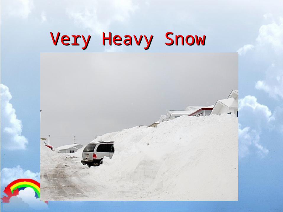
Very Heavy SnowVery Heavy Snow
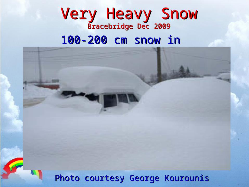
Very Heavy SnowVery Heavy SnowBracebridge Dec 2009Bracebridge Dec 2009
100-200 cm snow in 2 days100-200 cm snow in 2 days
Photo courtesy George KourounisPhoto courtesy George Kourounis
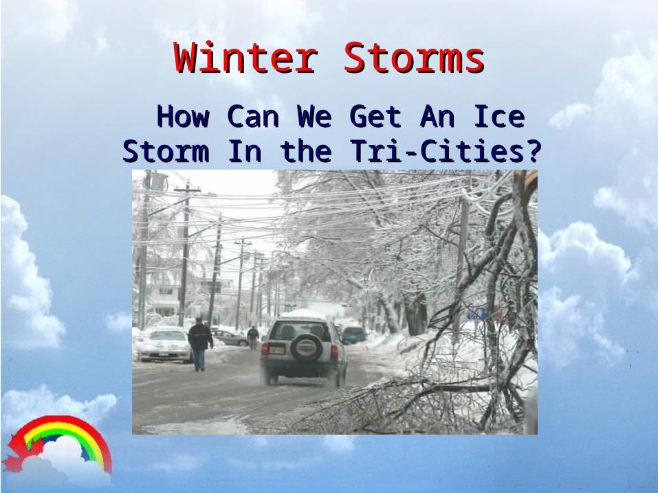
Winter StormsWinter StormsHow Can We Get An Ice Storm How Can We Get An Ice Storm
In the Tri-Cities? In the Tri-Cities?
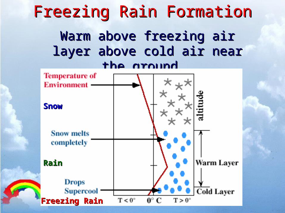
Freezing Rain FormationFreezing Rain Formation
Warm above freezing air layer Warm above freezing air layer above cold air near the above cold air near the
ground. ground.
Freezing RainFreezing Rain
RainRain
SnowSnow

Winter Ice Storm TracksWinter Ice Storm TracksMajor Ice Storms For Waterloo Region Major Ice Storms For Waterloo Region
LL
2-5 cm snow/Ice pellets2-5 cm snow/Ice pellets5-25 mm freezing rain5-25 mm freezing rain
A tale of two or three Texas Lows A tale of two or three Texas Lows
- Passing just south of us- Passing just south of us
- 2-3 periods of freezing rain - 2-3 periods of freezing rain
- one of these types every 2-3 years- one of these types every 2-3 years
- no change over to rain- no change over to rain
LL
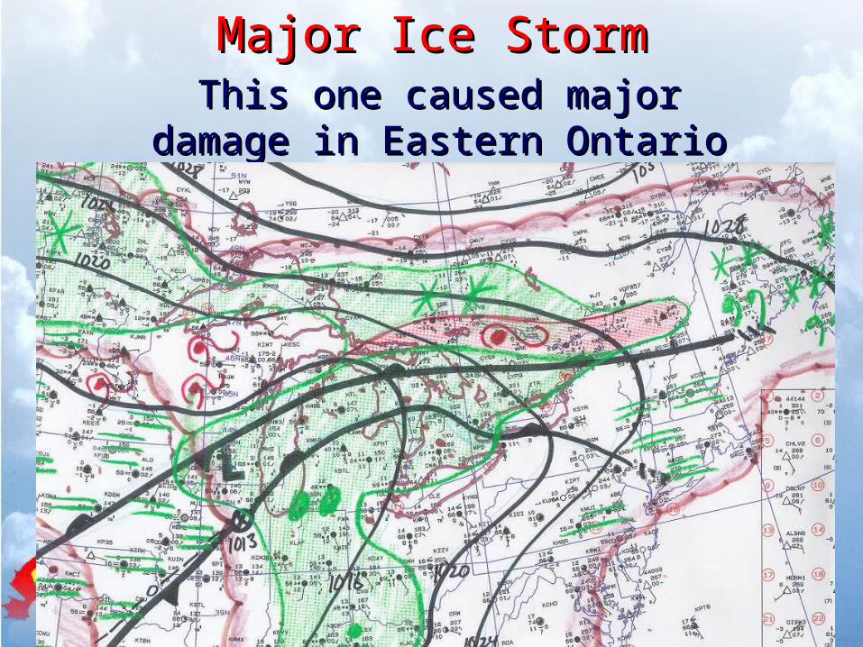
Major Ice StormMajor Ice StormThis one caused major This one caused major
damage in Eastern Ontario damage in Eastern Ontario and Quebec and Quebec
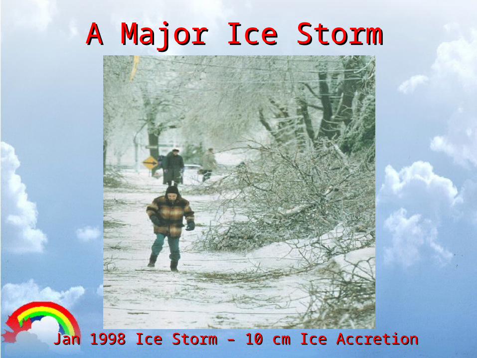
A Major Ice Storm A Major Ice Storm
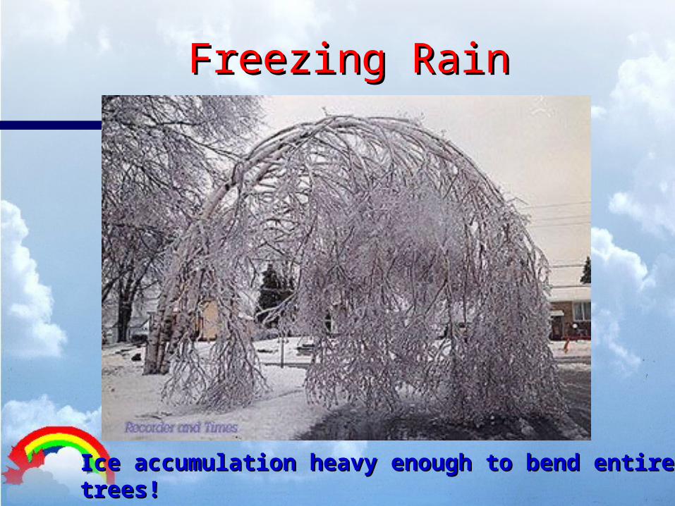
Jan 1998 Ice Storm – 10 cm Ice AccretionJan 1998 Ice Storm – 10 cm Ice Accretion
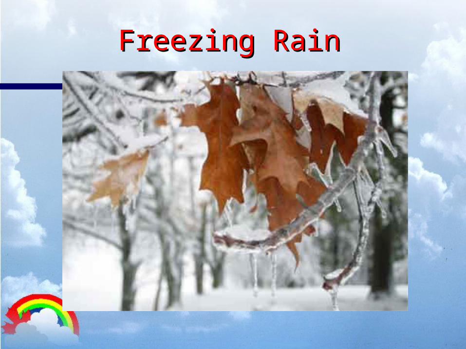
Freezing RainFreezing Rain
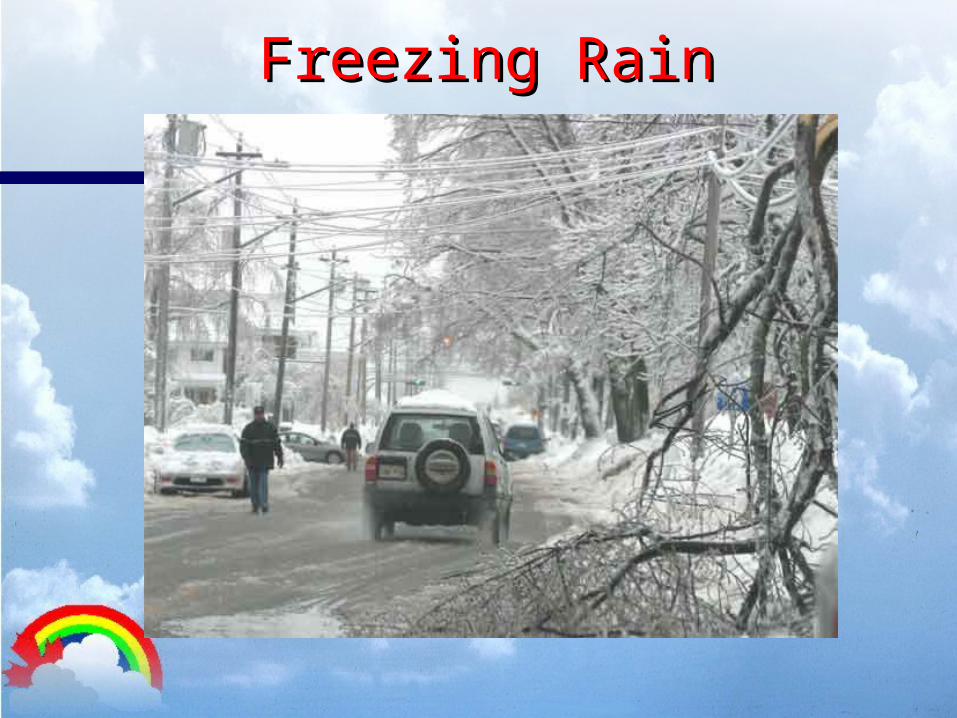
Freezing RainFreezing Rain
Freezing RainFreezing Rain
Ice accumulation heavy enough to bend entire trees! Ice accumulation heavy enough to bend entire trees!

SnowsquallsSnowsquallsLake Effect SnowLake Effect Snow
Waterloo RegionWaterloo Region

Lake Effect SnowLake Effect Snow• Waterloo region is on the edge of the Lake Huron snowbeltWaterloo region is on the edge of the Lake Huron snowbelt• Cold arctic air picks up moisture from Great LakesCold arctic air picks up moisture from Great Lakes• Winds blow in moisture and flurries to our areaWinds blow in moisture and flurries to our area• Heaviest lake effect snow usually just to our West and NorthHeaviest lake effect snow usually just to our West and North• Most common snow amounts for us .. Trace to 2 cm Most common snow amounts for us .. Trace to 2 cm • Snowsqualls – local lake effect snowstorms with heavy snow and/or strong windsSnowsqualls – local lake effect snowstorms with heavy snow and/or strong winds
There are exceptions though!!!!There are exceptions though!!!!
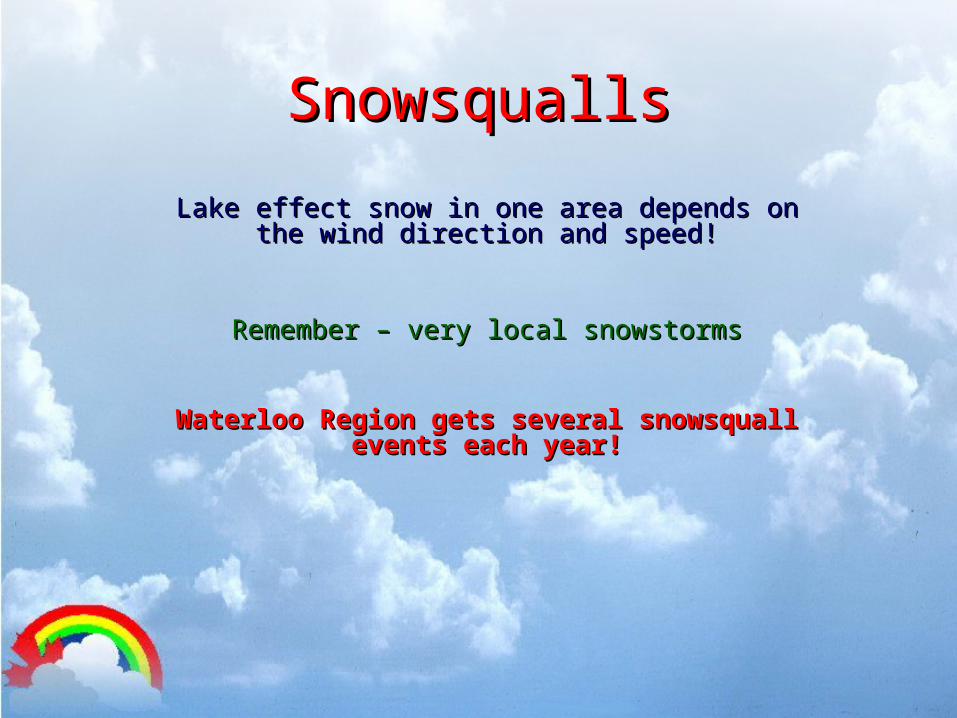
SnowsquallsSnowsqualls
Lake effect snow in one area depends on the Lake effect snow in one area depends on the wind direction and speed!wind direction and speed!
Remember – very local snowstormsRemember – very local snowstorms
Waterloo Region gets several snowsquall Waterloo Region gets several snowsquall events each year!events each year!
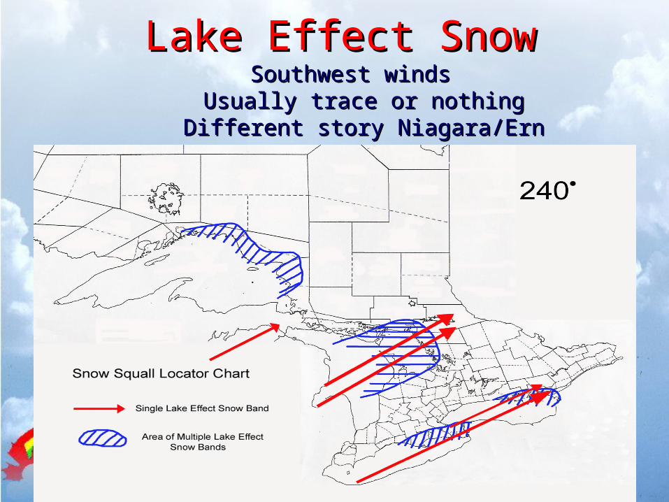
Lake Effect SnowLake Effect SnowSouthwest winds Southwest winds
Usually trace or nothing Usually trace or nothing Different story Niagara/Ern Ont/Bruce/Parry Different story Niagara/Ern Ont/Bruce/Parry
SoundSound
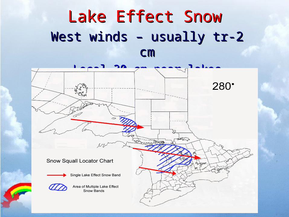
Lake Effect SnowLake Effect SnowWest winds – usually tr-2 cmWest winds – usually tr-2 cm
Local 30 cm near lakesLocal 30 cm near lakes

Lake Effect SnowLake Effect SnowNorthwest winds – best Northwest winds – best
directiondirection - 5-10 cm often occurs - 5-10 cm often occurs
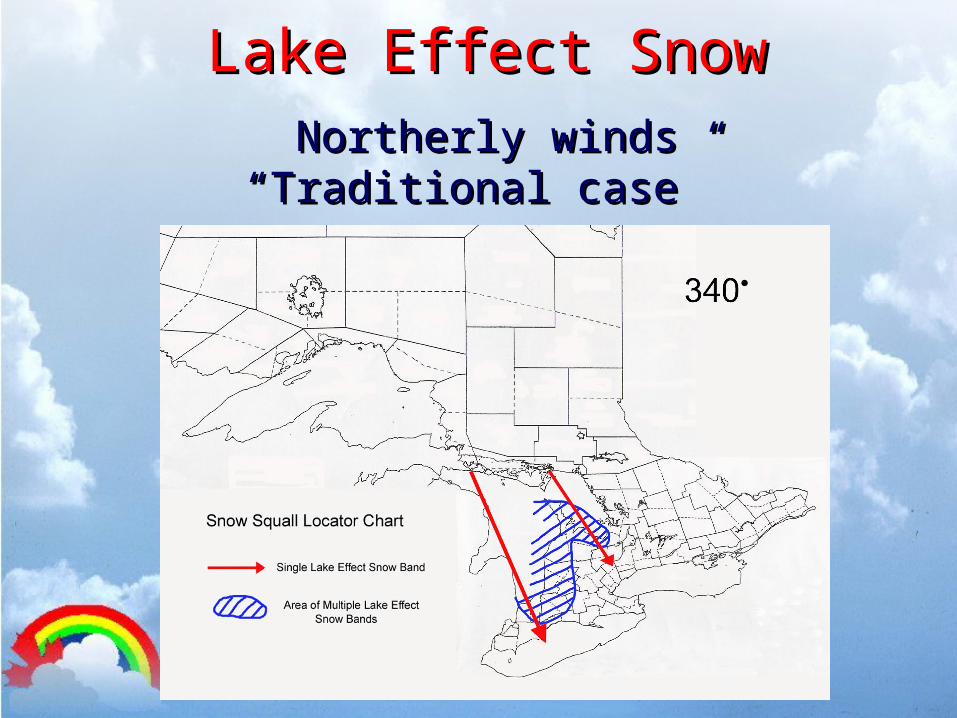
Lake Effect SnowLake Effect SnowNortherly windsNortherly winds
“Traditional case” “Traditional case”
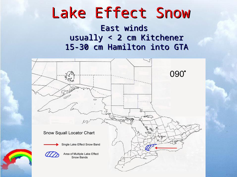
Lake Effect SnowLake Effect SnowEast winds East winds
usually < 2 cm Kitchener usually < 2 cm Kitchener 15-30 cm Hamilton into GTA15-30 cm Hamilton into GTA
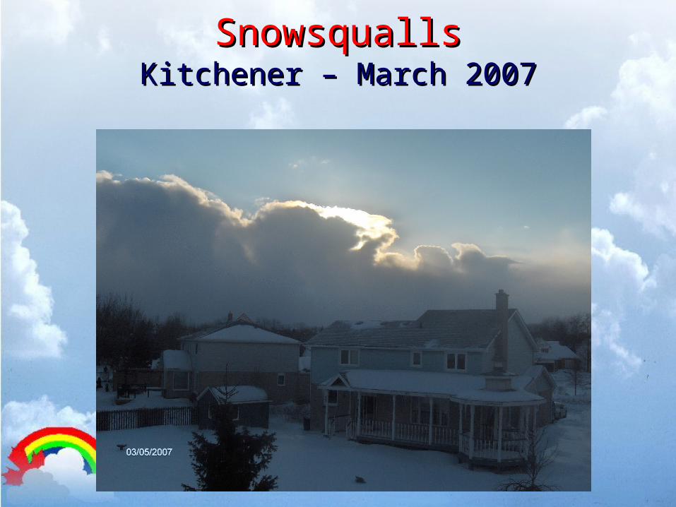
SnowsquallsSnowsquallsKitchener – March 2007Kitchener – March 2007
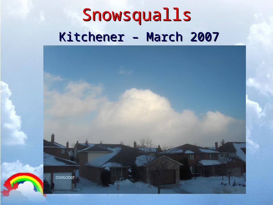
SnowsquallsSnowsquallsKitchener – March 2007Kitchener – March 2007
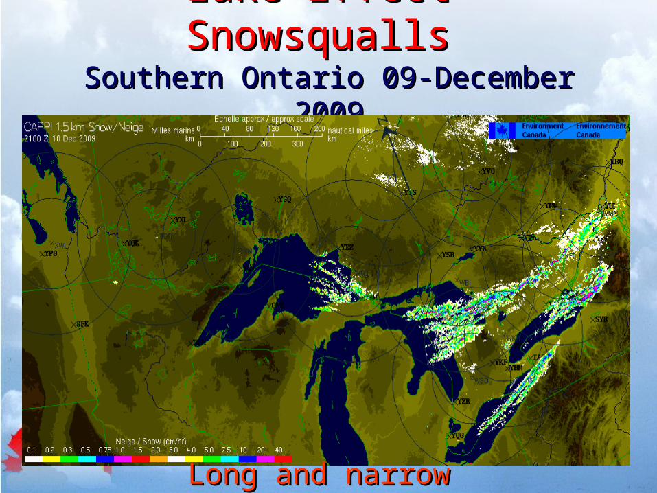
Lake Effect SnowsquallsLake Effect SnowsquallsSouthern Ontario 09-December Southern Ontario 09-December
20092009
Long and narrow stormsLong and narrow storms

SnowsquallsSnowsqualls Low visibility and heavy snow burstsLow visibility and heavy snow bursts Snowfall rates of 2-5 cm per hour Snowfall rates of 2-5 cm per hour
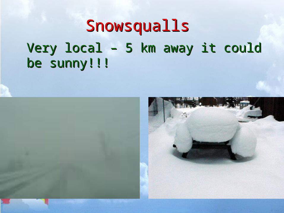
SnowsquallsSnowsqualls
Very local – 5 km away it could be sunny!!! Very local – 5 km away it could be sunny!!!
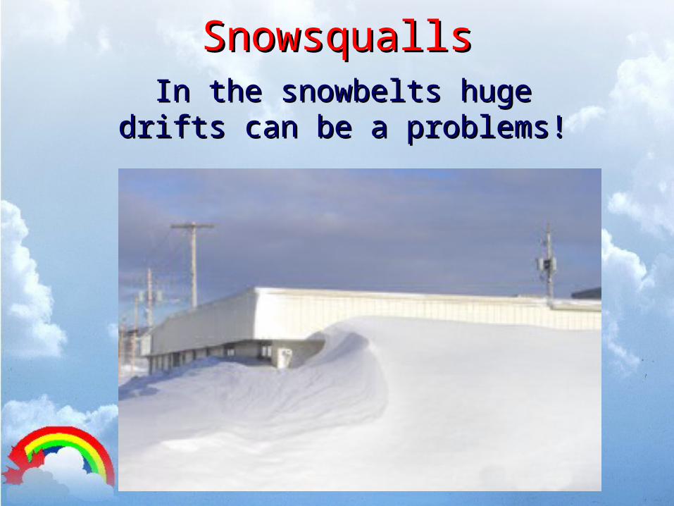
SnowsquallsSnowsquallsIn the snowbelts huge drifts In the snowbelts huge drifts
can be a problems!can be a problems!
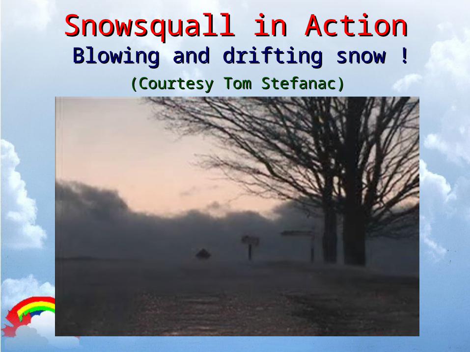
Snowsquall in ActionSnowsquall in ActionBlowing and drifting snow !Blowing and drifting snow !
(Courtesy Tom Stefanac)(Courtesy Tom Stefanac)
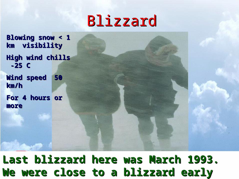
BlizzardBlizzard
Last blizzard here was March 1993.Last blizzard here was March 1993.We were close to a blizzard early February 2007.We were close to a blizzard early February 2007.
Blowing snow < 1 km Blowing snow < 1 km visibilityvisibility
High wind chills -25 C High wind chills -25 C
Wind speed 50 km/hWind speed 50 km/h
For 4 hours or moreFor 4 hours or more
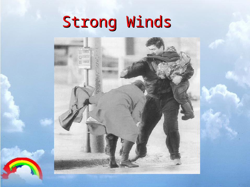
Strong WindsStrong Winds
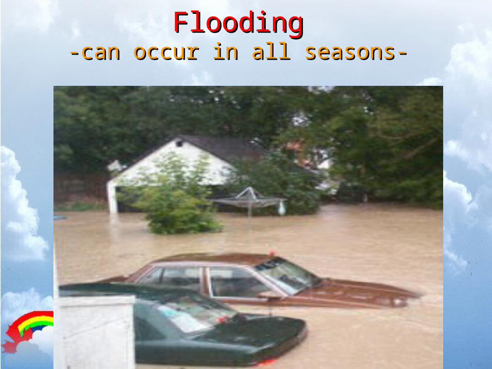
FloodingFlooding-can occur in all seasons--can occur in all seasons-
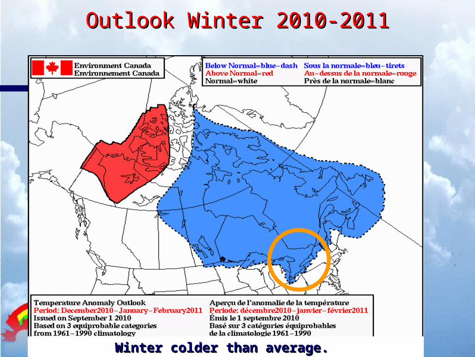
Outlook Winter 2010-2011Outlook Winter 2010-2011
Winter colder than average. Winter colder than average.
Outlook Winter 2010-2011Outlook Winter 2010-2011
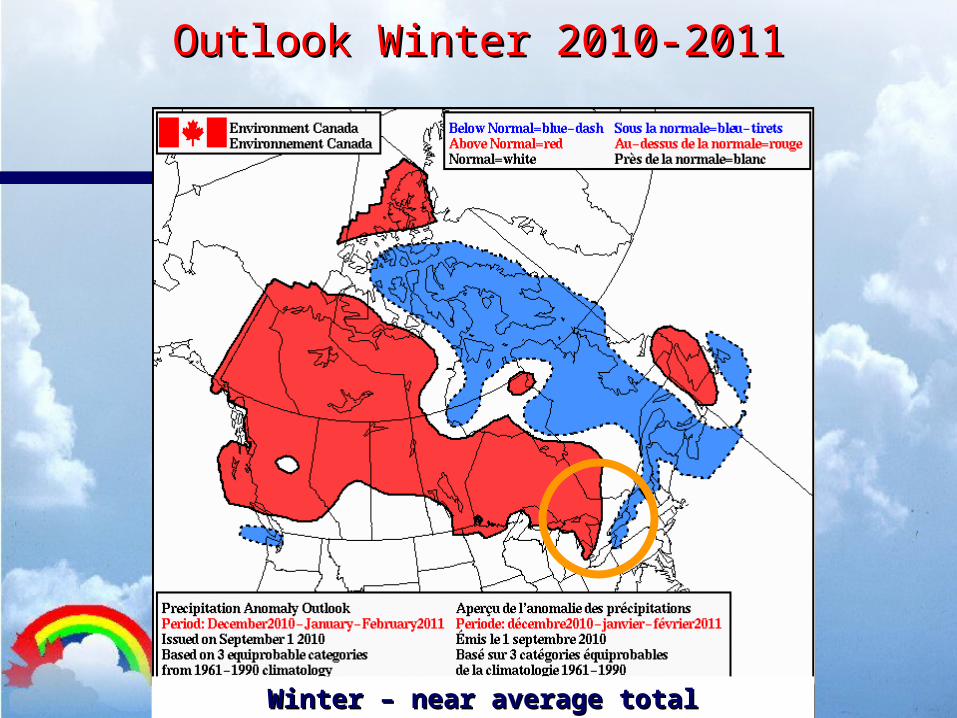
Winter – near average total precipitation. Winter – near average total precipitation.
Outlook Winter 2010-2011Outlook Winter 2010-2011
We’ll see what happens!We’ll see what happens!
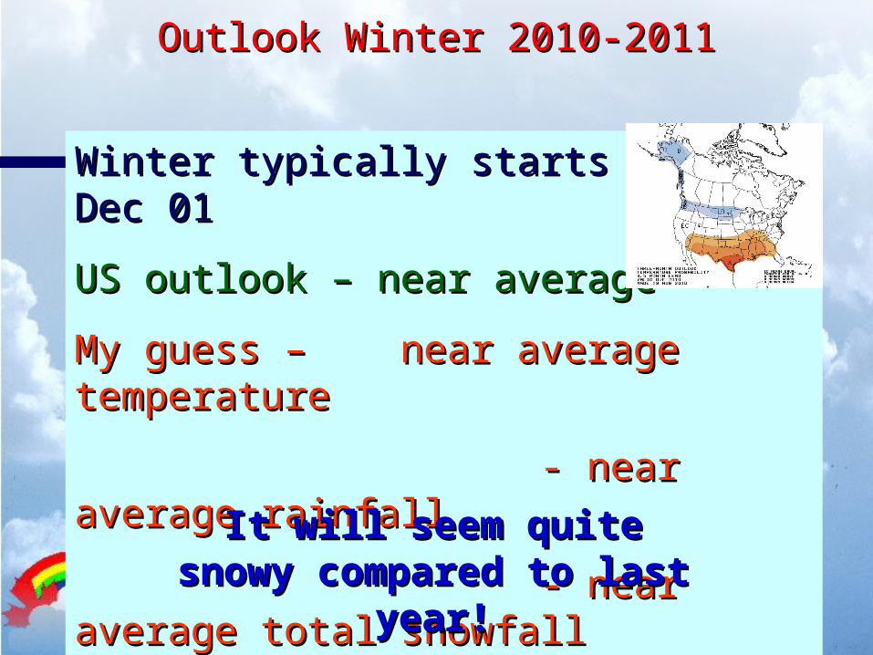
Winter typically starts near Dec 01Winter typically starts near Dec 01
US outlook – near averageUS outlook – near average
My guess – near average temperatureMy guess – near average temperature
- near average rainfall- near average rainfall
- near average total snowfall- near average total snowfall
It will seem quite snowy It will seem quite snowy compared to last year!compared to last year!
Some Weather Information Some Weather Information SitesSites
http://weatheroffice.ec.gc.cahttp://weatheroffice.ec.gc.cahttp://weather.uwaterloo.cahttp://weather.uwaterloo.ca
http://www.vaughanweather.comhttp://www.vaughanweather.comhttp://www.ontarioweather.comhttp://www.ontarioweather.com
http://www.msc-smc.ec.gc.ca/http://www.msc-smc.ec.gc.ca/information_publications_e.htmlinformation_publications_e.html
Questions?Questions?
A Major Winter Storm A Major Winter Storm Hard to scrape the car, eh??Hard to scrape the car, eh??
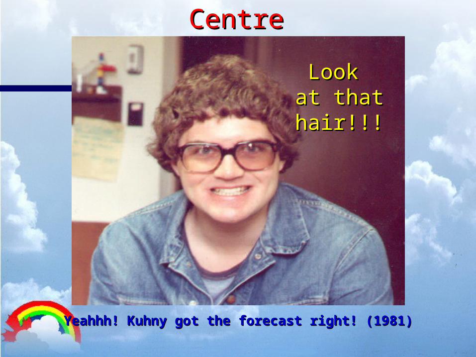
The Ontario Storm Prediction The Ontario Storm Prediction Centre Centre
Yeahhh! Kuhny got the forecast right! (1981)Yeahhh! Kuhny got the forecast right! (1981)
Look Look at that at that hair!!!hair!!!
Cheers!Cheers!