LANDSCAPE DEVELOPMENT GUIDELINES · LANDSCAPE DEVELOPMENT GUIDELINES FOR SUBDIVISION DEVELOPMENT |...
94
2019 GUIDELINES LANDSCAPE DEVELOPMENT
Transcript of LANDSCAPE DEVELOPMENT GUIDELINES · LANDSCAPE DEVELOPMENT GUIDELINES FOR SUBDIVISION DEVELOPMENT |...
2019
GUIDELINES LANDSCAPE DEVELOPMENT
1
CONTENTS
TERMS OF USE ........................................................................................................................ 6
PURPOSE OF THE LANDSCAPE DEVELOPMENT GUIDELINES .......................................... 7
INTERPRETATION OF THE LANDSCAPE DEVELOPMENT GUIDELINES ............................ 8
THE DEVELOPMENT PROCESS ............................................................................................. 9
The Roles of the Community Design Framework (CDF), Community Design Guidelines
(CDG) and Design Briefs ....................................................................................................10
PART I: SUBDIVISION DEVELOPMENT .................................................................................12
LANDSCAPE DEVELOPMENT GUIDELINES FOR SUBDIVISION DEVELOPMENT...........12
1.1. BOULEVARDS ...................................................................................................................... 12 1.1.1. Boulevard Trees ........................................................................................................... 12 1.1.2. Boulevard Buffers ......................................................................................................... 13 1.1.3. Arterial Roads .............................................................................................................. 14 1.1.4. Residential Reverse Frontages and Flankages ........................................................... 15 1.1.5. Collector Roads ............................................................................................................ 15 1.1.6. Local Roads ................................................................................................................. 15 1.1.7. Window Roads ............................................................................................................. 16 1.1.8. Alternative Design Standards (ADS) for Roads ........................................................... 17 1.1.9. Gateways and Other Streetscape Enhancements ....................................................... 17
1.1.9.1. Decorative Medians ................................................................................................. 17 1.1.9.2. Intersection Entry Features ..................................................................................... 18 1.1.9.3. Special Boulevard Surface Treatments and Street Furniture ................................. 20
1.1.10. Boulevards Grading ..................................................................................................... 20 1.2. PARK TYPOLOGY ................................................................................................................ 20
1.2.1. City Parks ..................................................................................................................... 20 1.2.2. Community Parks ......................................................................................................... 21 1.2.3. Neighbourhood Parks .................................................................................................. 21
1.2.3.1. General Requirements ............................................................................................ 21 1.2.3.2. Playground Design .................................................................................................. 21 1.2.3.3. Local Parks .............................................................................................................. 23 1.2.3.4. Town Squares ......................................................................................................... 23 1.2.3.5. Vest Pocket Parks ................................................................................................... 23 1.2.3.6. Urban Parks ............................................................................................................ 24 1.2.3.7. Linear Connectors ................................................................................................... 24
1.2.4. Sports Facilities ............................................................................................................ 24 1.2.5. Neighbourhood Park: Parking ...................................................................................... 24 1.2.6. Neighbourhood Park: Planting ..................................................................................... 26 1.2.7. Neighbourhood Park: Site Grading .............................................................................. 27 1.2.8. Neighbourhood Park: Site Furniture ............................................................................ 27 1.2.9. Neighbourhood Park: Shade Structures ...................................................................... 27
1.2.9.1. Shade Structure Proportions, Shape and Size ....................................................... 28 1.2.9.2. Shade Structure Flooring ........................................................................................ 28 1.2.9.3. Shade Structure Colour and Materials .................................................................... 28
2
1.2.9.4. Shade Structure Lighting and Electrical .................................................................. 28 1.2.9.5. Shade Structure Accessibility .................................................................................. 28
1.2.10. Neighbourhood Park: Lighting ..................................................................................... 29 1.2.11. Neighbourhood Park: Fencing ..................................................................................... 29
1.3. NATURAL HERITAGE .......................................................................................................... 29 1.3.1. Valleylands ................................................................................................................... 29
1.3.1.1. Access and Linkages .............................................................................................. 30 1.3.1.2. Invasive Species ..................................................................................................... 30 1.3.1.3. Habitat Enhancement .............................................................................................. 30 1.3.1.4. Restoration Planting ................................................................................................ 31 1.3.1.5. Environmental Buffer ............................................................................................... 31
1.3.2. Woodlands ................................................................................................................... 31 1.3.2.1. General Requirements ............................................................................................ 32 1.3.2.2. Pedestrian Access and Linkages ............................................................................ 32 1.3.2.3. Conservation of Biotic Resources ........................................................................... 32 1.3.2.4. Restoration Planting ................................................................................................ 32 1.3.2.5. Woodlot Edge Re-Establishment ............................................................................ 33 1.3.2.6. Invasive Species ..................................................................................................... 33 1.3.2.7. Habitat Enhancement .............................................................................................. 33 1.3.2.8. Environmental Buffer ............................................................................................... 34
1.3.3. Wetlands ...................................................................................................................... 34 1.3.3.1. Access and Linkages .............................................................................................. 34 1.3.3.2. Invasive Species ..................................................................................................... 35 1.3.3.3. Restoration Planting ................................................................................................ 35 1.3.3.4. Environmental Buffer ............................................................................................... 35
1.4. STORMWATER MANAGEMENT FACILITIES ..................................................................... 35 1.4.1. Pedestrian Access and Linkages ................................................................................. 36 1.4.2. Planting ........................................................................................................................ 37 1.4.3. Safety Stations and Warning Signage ......................................................................... 38
1.5. TABLELAND TREES ............................................................................................................ 39 1.6. CEMETERIES ....................................................................................................................... 39 1.7. RECREATIONAL TRAILS AND PATHWAYS ....................................................................... 39
1.7.1. Boulevard Multi-Use Recreational trail (Class 1) ......................................................... 40 1.7.2. Off-Road Multi-Use Path (Class 1) .............................................................................. 40 1.7.3. On-Road Bicycle Lane (Class 2) .................................................................................. 40 1.7.4. Bicycle Lane with On-Street Parking (Class 2) ............................................................ 40 On-Street Signed Route (Class 2) ............................................................................................. 40
1.8. SUPPLEMENTARY DESIGN REQUIREMENTS .................................................................. 41 1.8.1. Site Grading ................................................................................................................. 42 1.8.2. Sodding and Seeding ................................................................................................... 42 1.8.3. Planting ........................................................................................................................ 42 1.8.4. Retaining Walls ............................................................................................................ 42 1.8.5. Fencing ......................................................................................................................... 43 1.8.6. Signage ........................................................................................................................ 43
LANDSCAPE SUBMISSIONS FOR SUBDIVISION DEVELOPMENT ...................................44 1.9. General Requirements .......................................................................................................... 44
1.9.1. Applicant’s Responsibilities .......................................................................................... 44 1.9.2. Consultant’s Responsibilities ....................................................................................... 44
1.10. Submissions Prior to Draft Plan Approval ............................................................................. 44
3
1.10.1. Concept Plan ................................................................................................................ 44 1.11. Submissions Prior to Registration of Subdivision .................................................................. 45
1.11.1. Plan Format .................................................................................................................. 45 1.11.2. Tree Preservation Plan Prior to Pre-Servicing ............................................................. 46 1.11.3. Woodland Development Plan ...................................................................................... 46 1.11.4. 1st Landscape Submission ........................................................................................... 46 1.11.5. 2nd Landscape Submission .......................................................................................... 48 1.11.6. Final Landscape Submission and Plan Approval (Hard Copies) ................................. 48 1.11.7. Digital Plan Requirements for Final Submission .......................................................... 49
LANDSCAPE CONSTRUCTION FOR SUBDIVISION DEVELOPMENT ...............................49 1.12. Tender Documents, Review, and Award of Contract (For Works Eligible for Levy Credit only
– City Costs) ................................................................................................................................... 49 1.13. Pre-Construction Meeting (All Works) ................................................................................... 49 1.14. Weekly Progress Inspections (for Works Eligible for Levy Credit only – City Costs) ............ 50
COMPLETION OF LANDSCAPE WORK FOR SUBDIVISON DEVELOPMENT ...................50 1.15. Preliminary Acceptance ......................................................................................................... 50 1.16. Payment Certificates (for Works Eligible for Levy Credit only – City Costs) ......................... 52 1.17. One Year Interim Inspection .................................................................................................. 52 1.18. Final Acceptance ................................................................................................................... 53 1.19. Security Reductions .............................................................................................................. 54 1.20. Subdivision Release and Assumption ................................................................................... 55
PART 2: SITE PLAN DEVELOPMENT.....................................................................................56
LANDSCAPE DEVELOPMENT GUIDELINES FOR SITE PLAN DEVELOPMENT ...............56
1.1. General Considerations ......................................................................................................... 56 1.2. Industrial ................................................................................................................................ 56
1.2.1. Design Objectives ........................................................................................................ 56 1.2.2. Design Requirements ................................................................................................... 56
1.3. Commercial ........................................................................................................................... 57 1.3.1. Design Objectives ........................................................................................................ 57 1.3.2. Design Requirements ................................................................................................... 57
1.4. High-Density Residential ....................................................................................................... 57 1.4.1. Design Objectives ........................................................................................................ 57 1.4.2. Design Requirements ................................................................................................... 57
1.5. Medium-Density Residential .................................................................................................. 58 1.5.1. Design Objectives ........................................................................................................ 58 1.5.2. Design Requirements ................................................................................................... 59
1.6. Institutional (Government Offices, Schools, Churches, Utility Buildings) .............................. 59 1.6.1. Design Objectives ........................................................................................................ 59 1.6.2. Design Requirements ................................................................................................... 59
1.7. Supplementary Design Requirements .................................................................................. 60 1.7.1. Street Frontage Buffering ............................................................................................. 60 1.7.2. Side Yard Treatment .................................................................................................... 60 1.7.3. Parkland and Public Open Space Buffering ................................................................. 60 1.7.4. Plant Material ............................................................................................................... 60 1.7.5. Curbing ......................................................................................................................... 61 1.7.6. Existing Vegetation ...................................................................................................... 61 1.7.7. Landscape Traffic Islands ............................................................................................ 61
4
1.7.8. Lighting ......................................................................................................................... 61 1.7.9. Fencing ......................................................................................................................... 62
LANDSCAPE SUBMISSIONS FOR SITE PLAN DEVELOPMENT ........................................62 1.8. General Responsibilities ........................................................................................................ 62 1.9. Submissions for Site Plan Approval ...................................................................................... 62
1.9.1. Plan Format and Drawing Requirements ..................................................................... 62 1.9.1.1. Size .......................................................................................................................... 62 1.9.1.2. Organization ............................................................................................................ 62 1.9.1.3. Drawing and Reproduction Quality ......................................................................... 62 1.9.1.4. Essential Information ............................................................................................... 62 1.9.1.5. Graphic Symbols ..................................................................................................... 63 1.9.1.6. Existing Trees .......................................................................................................... 63 1.9.1.7. Proposed Trees and Shrubs ................................................................................... 63 1.9.1.8. Reports and Cost Estimates ................................................................................... 63 1.9.1.9. Standard Notes ....................................................................................................... 63 1.9.1.10. Specifications and Details ................................................................................... 64 1.9.1.11. Plan Approval and Securities .............................................................................. 65
LANDSCAPE CONSTRUCTION FOR SITE PLAN DEVELOPMENT ....................................65
COMPLETION OF LANDSCAPE WORK FOR SITE PLAN DEVELOPMENT .......................65 1.10. Preliminary Acceptance ......................................................................................................... 65 1.11. Warranty Period..................................................................................................................... 65 1.12. Final Acceptance ................................................................................................................... 65 1.13. Security Reduction ................................................................................................................ 66
PART III: APPENDICES .........................................................................................................67
Appendix A: Recreational Pathways Hierarchy .....................................................................68
Appendix B: Plant Chart ........................................................................................................69
Appendix C: Subdivision and Site Plan Fencing and Wall Standards ....................................78
Appendix D: Schedule of Quantities ......................................................................................82
Appendix E: Parkland Development Bid Comparison Form ...................................................83
Appendix F: Status Report for Preliminary and Final Acceptance ..........................................88
Appendix G: Certification of Landscape Works for Subdivision Development ........................90
Appendix H: Certification of Landscape Works for Site Plan Development ............................92
Appendix I: References .........................................................................................................93
5
LIST OF FIGURES
Figure 1 Typical Street Tree Planting Scheme ..........................................................................12
Figure 2 Typical street tree spacing along a local road with reduced front yard setbacks ..........16
Figure 3 Typical landscape treatment along a window road ......................................................17
Figure 4 Typical landscape treatment along residential reverse frontage lots ... Error! Bookmark
not defined.
Figure 5 Typical median landscape treatment ...........................................................................18
Figure 6 Developer-initiated entry feature .................................................................................20
Figure 7 Park theming - entry treatment ....................................................................................21
Figure 8 Park theming - shade structure ...................................................................................21
Figure 9 Typical landscape treatment for parking lot in a park ...................................................26
Figure 10 Asphalt recreational trail in valley land ......................................................................30
Figure 11 Granular recreational trail in valley land ....................................................................30
Figure 12 Typical walkway connection ......................................................................................41
LIST OF TABLES
Table 1 Common boulevard trees categorized by form and texture...........................................13
Table 2 Summary of Landscape Works for Security Reductions (Sample) ................................54
LANDSCAPE DEVELOPMENT GUIDELINES FOR SUBDIVISION DEVELOPMENT | BOULEVARDS
6
TERMS OF USE
This is a living document that will be updated from time to time by the City of Brampton.
Use of information contained in the Landscape Design Guidelines does not absolve the reader
from the obligation to exercise their best professional judgment and follow good practice.
The reader is advised to seek clarification from the City should there be a concern or conflict with
the information provided herein and their proposed development.
The City of Brampton, at their discretion, may consider alternatives to these guidelines when the
developer (or their agent) provides a written request for special consideration identifying the
reasons.
For further information or questions pertaining to the document, the applicant is encouraged to
contact the Park Planning & Development Section at (905) 874-3448.
LANDSCAPE DEVELOPMENT GUIDELINES FOR SUBDIVISION DEVELOPMENT | BOULEVARDS
7
PURPOSE OF THE LANDSCAPE DEVELOPMENT GUIDELINES
This document is a guide to assist landowners, developers, and consultants in the
development of public open space within the City of Brampton. For the purpose of this
document, open space includes, but is not limited to, parks, streetscapes, buffers,
recreational trail systems, cemeteries, woodlands, valley lands, hazard lands, natural
heritage systems and NHS blocks, engineered channels, and stormwater management
facilities. This document is intended to further build on the City’s vision, as described in
the Strategic Plan1 and the Development Design Guidelines2, by clearly outlining the
process and minimum design requirements necessary to complete the open space
components associated with all new development.
The objective of this document is to ensure that consistently high standards of
landscape development are delivered through the implementation of the following
procedures and guidelines.
1 City of Brampton. Strategic Plan. City of Brampton website. 2 City of Brampton. Development Design Guidelines. City of Brampton website.
LANDSCAPE DEVELOPMENT GUIDELINES FOR SUBDIVISION DEVELOPMENT | BOULEVARDS
8
INTERPRETATION OF THE LANDSCAPE DEVELOPMENT GUIDELINES
This document deals with lands owned by the City of Brampton, boulevards and buffers
owned by the Region of Peel, and private open space regulated by the City’s site plan
control process, all of which are categorized as open space according to the preceding
definition.
The design and development of public open space is subject, but not limited to, the
Planning Act, the Official Plan, the Strategic Plan, the Development Design Guidelines,
the Subdivision Design Manual3, the Sustainable Community Development Guidelines4,
the Construction Manual for Subdivision Development5, the Accessibility Technical
Standards6 and all of their amendments. These documents shall be read in conjunction
with these guidelines for a complete understanding of the development process in
Brampton. Development of public open space is also subject, but not limited to, the
regulations and standards administered by the Ministry of Natural Resources and
Forestry, Ministry of the Environment and Climate Change; Toronto and Region
Conservation; Credit Valley Conservation; and the Region of Peel. The principles of
CPTED (Crime Prevention through Environmental Design) shall also be incorporated with
the guidelines outlined in this document.
A general overview of the process and technical requirements for the development of
public open space is discussed in these guidelines and applies to all developments. As
changes in policy and technical requirements occur from time to time, the City issues
notices to those consultants who are on our mailing list. It is recommended that the
Applicant, or their representative, should always refer to the City’s website to obtain the
most recent update of or amendment to this document prior to preparing submissions to
the City.
3 City of Brampton. Subdivision Design Manual. City of Brampton website. 4 City of Brampton. Sustainable Community Development Guidelines. City of Brampton website. 5 City of Brampton. Construction Manual for Subdivision Development. City of Brampton website. 6 City of Brampton. Accessibility Technical Standards. City of Brampton website.
LANDSCAPE DEVELOPMENT GUIDELINES FOR SUBDIVISION DEVELOPMENT | BOULEVARDS
9
THE DEVELOPMENT PROCESS
As Brampton continues to rapidly grow over the next number of years, most of the City’s
open space development will be associated with and implemented through the
Subdivision Application and Site Plan processes. Because there are significant
differences in the procedures and technical requirements, each process is dealt with
separately in these guidelines.
Following Draft Plan approval, the submission of a Landscape Plan will be concurrent
with submission of the Engineering Plan. Plans of Subdivision will only be released for
registration after all of the City’s requirements have been satisfied and the landscape (and
engineering) plans have been approved.
Site plan landscape submissions may be made to the City concurrent with the initial Site
Plan application, or at any time thereafter. Site plan approval will not be granted until the
landscape plans are approved.
These guidelines are supported by several companion City of Brampton documents which
include, but are not necessarily limited to the following:
Official Plan
Strategic Plan
Secondary Plan and Block Plan Policies
Community Design Framework (CDF) for the development area
Community Design Guidelines (CDG) or Design Briefs for the development area
Site Plan Review Process Document
Subdivision Design Manual
Development Design Guidelines
Sustainable Community Development Guidelines
Construction Manual for Subdivision Development
Accessibility Technical Standards
Street Corridor Master Plan and Design Standards
Brampton’s PathWays Master Plan
Gateway Beautification Program
Parks and Recreation Master Plan
LANDSCAPE DEVELOPMENT GUIDELINES FOR SUBDIVISION DEVELOPMENT | BOULEVARDS
10
Conditions of Draft Plan approval for the subdivision
All due consideration should also be given to other applicable regulations and guidelines
including but not limited to the:
Municipal Act
Planning Act
Conservation Authorities Act
Navigable Waters Protection Act
Environmental Assessment Act
Endangered Species Act
Ontario Heritage Act
Ontario Building Code
City of Brampton Development Charges By-law
City of Brampton Zoning By-law
The Roles of the Community Design Framework (CDF), Community
Design Guidelines (CDG) and Design Briefs
Most new development in Brampton, with the exception of a few infill projects, originates
through the Block Plan. Please refer to the Development Design Guidelines for further
information related to the design process.
The design aspects of the proposed neighbourhoods within a block plan are first
considered in the Community Design Framework (CDF), one of several component
studies that contribute to the creation of the Secondary Plan.
The CDF identifies the opportunities that exist within a given area that will be capitalized
on to influence the overall design of a community and the establishment of a land use
plan. The CDF focuses on the basic structuring elements of the community including the
arrangement of various land uses, public open space, stormwater management ponds
and the road network that delineates them. More importantly, it identifies special
character areas that will give the new community distinctiveness and a sense of place.
Other important supporting infrastructure including recreational pathway systems, as well
as cultural and natural heritage features, will also be identified and integrated into the
planning process at this stage. With respect to recreational pathways that are
contemplated in natural areas, there is an increasing need to investigate alternative
LANDSCAPE DEVELOPMENT GUIDELINES FOR SUBDIVISION DEVELOPMENT | BOULEVARDS
11
alignments as early as possible in the process. This is usually done in conjunction with
the Environmental Implementation Report (EIR) and Master Environmental Servicing
Plan (MESP) to ensure that key environmental constraints are identified and adjustments
can be made accordingly.
The next level of detail is captured in the Community Design Guidelines (CDG), which is
also prepared by the applicant and submitted as part of the block planning process. This
document supplements the City’s ‘parent’ document, the Development Design
Guidelines, by describing the unique and special design features that will distinguish the
proposed community, with particular emphasis on the special character areas that have
been identified in the CDF. The information provided in this document should be
immediately translatable into detailed design drawings at the subdivision design stage
without the need for a lot of interpretation by the designer.
Design Briefs are an abbreviated form of Community Design Guidelines that are typically
required for stand-alone sites that are regulated through the Site Plan approval process.
Because of the relatively small scale involved, the recommendations tend to be very site-
specific and even more prescriptive than those in the Community Design Guidelines.
LANDSCAPE DEVELOPMENT GUIDELINES FOR SUBDIVISION DEVELOPMENT | BOULEVARDS
12
PART I: SUBDIVISION DEVELOPMENT
LANDSCAPE DEVELOPMENT GUIDELINES FOR SUBDIVISION DEVELOPMENT
This section is intended to provide an overview of the main design considerations and
requirements for landscaping and outdoor recreation facilities related to new developments.
1.1. BOULEVARDS
Street trees, along with lighting, street furniture, signage, and built form, play a key role in
defining the character, visual appeal, and functionality of a street. More importantly, they
provide a major proportion of the City’s tree canopy, which is essential to the environmental
sustainability of the City and the health of its residents and visitors.
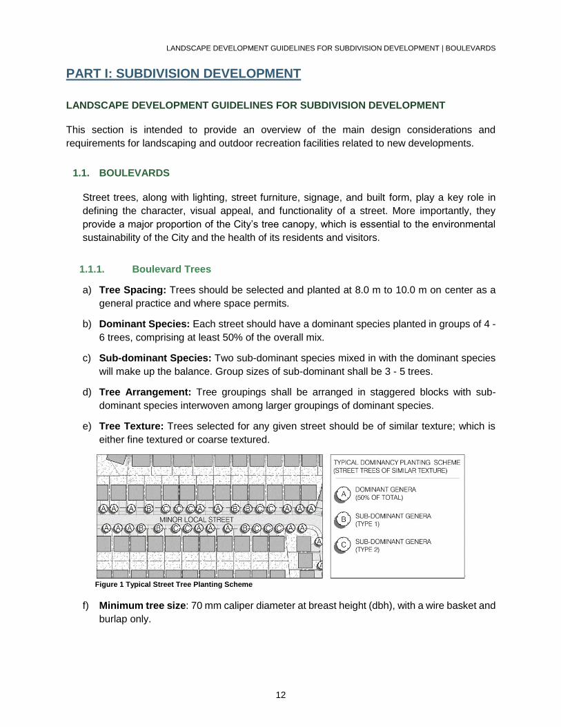
1.1.1. Boulevard Trees
a) Tree Spacing: Trees should be selected and planted at 8.0 m to 10.0 m on center as a
general practice and where space permits.
b) Dominant Species: Each street should have a dominant species planted in groups of 4 -
6 trees, comprising at least 50% of the overall mix.
c) Sub-dominant Species: Two sub-dominant species mixed in with the dominant species
will make up the balance. Group sizes of sub-dominant shall be 3 - 5 trees.
d) Tree Arrangement: Tree groupings shall be arranged in staggered blocks with sub-
dominant species interwoven among larger groupings of dominant species.
e) Tree Texture: Trees selected for any given street should be of similar texture; which is
either fine textured or coarse textured.
Figure 1 Typical Street Tree Planting Scheme
f) Minimum tree size: 70 mm caliper diameter at breast height (dbh), with a wire basket and
burlap only.

LANDSCAPE DEVELOPMENT GUIDELINES FOR SUBDIVISION DEVELOPMENT | BOULEVARDS
13
g) Soil: Individually planted trees require a minimum of 30 cubic meters (m3) of soil per tree,
while groupings of two or more in a soil bed require a minimum of 20 cubic meters (m3)
of soil per tree.
h) Soil depth: A minimum of 0.7 meters of soil depth.
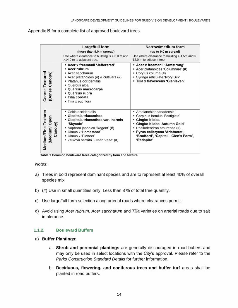
The following table classifies the most common boulevard trees into four categories based on
form and texture. Please refer to
LANDSCAPE DEVELOPMENT GUIDELINES FOR SUBDIVISION DEVELOPMENT | BOULEVARDS
14
Appendix B for a complete list of approved boulevard trees.
Large/full form (more than 9.0 m spread)
Narrow/medium form (up to 9.0 m spread)
Use where clearance to building is > 6.0 m and >14.0 m to adjacent tree.
Use where clearance to building > 4.5m and > 12.0 m to adjacent tree.
Co
ars
e T
extu
red
(Den
se C
an
op
y)
Acer x freemanii ‘Jeffersred’ Acer rubrum
Acer saccharum Acer platanoides (#) & cultivars (#) Platanus occidentalis Quercus alba Quercus macrocarpa Quercus rubra Tilia cordata
Tilia x euchlora
Acer x freemanii ‘Armstrong’
Acer platanoides ‘Columnare’ (#) Corylus colurna (#) Syringa reticulate ‘Ivory Silk’ Tilia x flavescens ‘Glenleven’
Med
ium
/Fin
e T
extu
red
(Med
ium
/ O
pen
Can
op
y)
Celtis occidentalis Gleditsia triacanthos Gleditsia triacanthos var. inermis
‘Skycole’
Sophora japonica ‘Regent’ (#) Ulmus x ‘Homestead’ Ulmus x ‘Pioneer’ Zelkova serrata ‘Green Vase’ (#)
Amelanchier canadensis Carpinus betulus ‘Fastigiata’ Gingko biloba Gingko biloba ‘Autumn Gold’
Phellodendron amurense (#) Pyrus calleryana ‘Aristocrat’,
‘Bradford’, ‘Capital’, ‘Glen’s Form’, ‘Redspire’
Table 1 Common boulevard trees categorized by form and texture
Notes:
a) Trees in bold represent dominant species and are to represent at least 40% of overall
species mix.
b) (#) Use in small quantities only. Less than 8 % of total tree quantity.
c) Use large/full form selection along arterial roads where clearances permit.
d) Avoid using Acer rubrum, Acer saccharum and Tilia varieties on arterial roads due to salt
intolerance.
1.1.2. Boulevard Buffers
a) Buffer Plantings:
a. Shrub and perennial plantings are generally discouraged in road buffers and
may only be used in select locations with the City’s approval. Please refer to the
Parks Construction Standard Details for further information.
b. Deciduous, flowering, and coniferous trees and buffer turf areas shall be
planted in road buffers.
LANDSCAPE DEVELOPMENT GUIDELINES FOR SUBDIVISION DEVELOPMENT | BOULEVARDS
15
c. Coniferous tree plantings shall be a mix of three specimen heights (180 cm, 250
cm and 300 cm) in approximately equal proportions. Coniferous trees shall be
planted in buffer turf and shall have individual mulched saucers with a minimum of
3.0 meters of turf between saucers.
1.1.3. Arterial Roads
These streets form the edges and boundaries of the community.
a) Planting: Deciduous and coniferous tree rows and groupings, entry feature shrub and
perennial plantings, and berming as required for noise mitigation. Plantings are to be
located in designated planting buffers.
b) Architectural Components: Decorative acoustic wall and/or fencing as required.
c) Tree Size: Large canopy trees are preferred along arterial roads. However, this objective
may need to be compromised with the introduction of smaller or narrow form selections in
close proximity to overhead utilities.
d) Species: Selected for their tolerance to road salt and winter hardiness.
e) Setback: Optimum tree setback from the roadway is 7.0 m where attainable.
f) Arterial Road Buffers: Bulb plantings are to be provided through the following method:
o For arterial road buffer sod areas, landscape drawings shall indicate planting
locations for early flowering bulbs such as Scilla, Crocus, Chionodoxa and
Puschkinia.
o The average planting coverage is 10 square meters of mass bulb planting for
every 10 linear meters of road buffer, although the exact extent of this planting
will depend on the available space as agreed to with the City.
o A note is required on the affected drawings stating that the City will collect cash-
in-lieu from the developer at the rate of $80.00 / square meter (subject to market
costs at the time) and that the City will use these funds to provide the bulb
plantings at a later date.
o The specific design and layout of the flowering bulb clusters will vary, depending
on site conditions.
1.1.4. Residential Reverse Frontages and Flankages
In this arrangement, residential lots back or flank onto an arterial road with the front yard facing a
local street.
LANDSCAPE DEVELOPMENT GUIDELINES FOR SUBDIVISION DEVELOPMENT | BOULEVARDS
16
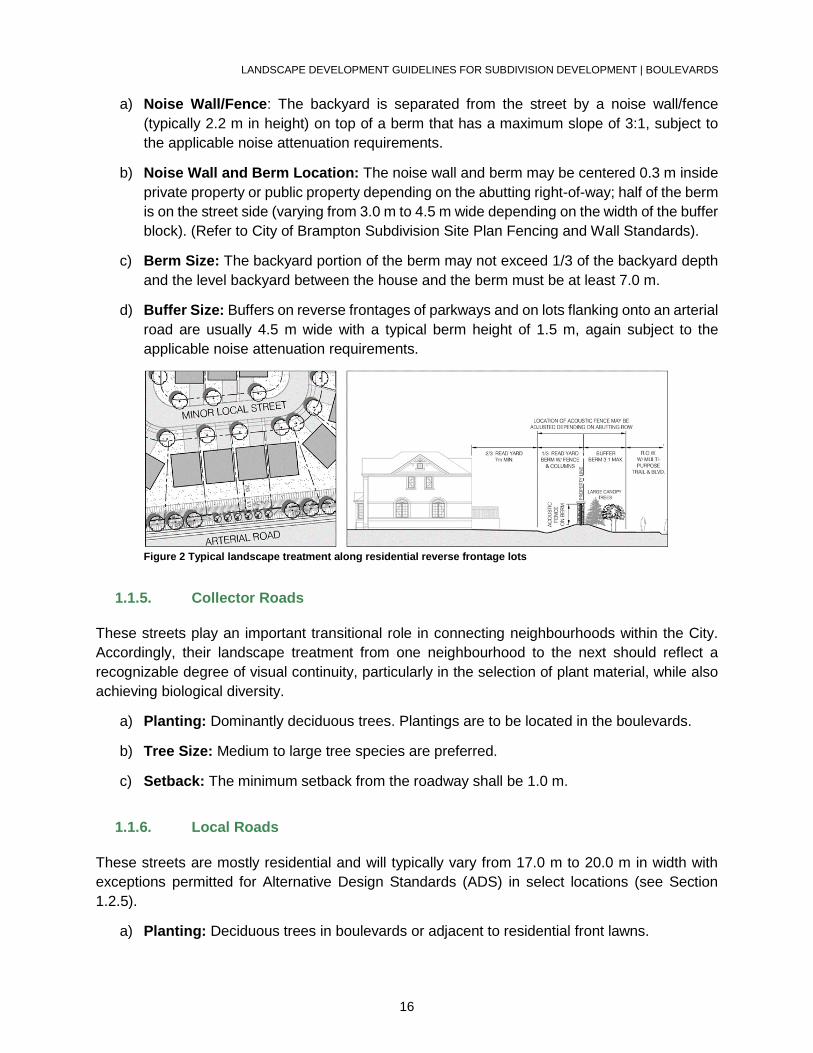
a) Noise Wall/Fence: The backyard is separated from the street by a noise wall/fence
(typically 2.2 m in height) on top of a berm that has a maximum slope of 3:1, subject to
the applicable noise attenuation requirements.
b) Noise Wall and Berm Location: The noise wall and berm may be centered 0.3 m inside
private property or public property depending on the abutting right-of-way; half of the berm
is on the street side (varying from 3.0 m to 4.5 m wide depending on the width of the buffer
block). (Refer to City of Brampton Subdivision Site Plan Fencing and Wall Standards).
c) Berm Size: The backyard portion of the berm may not exceed 1/3 of the backyard depth
and the level backyard between the house and the berm must be at least 7.0 m.
d) Buffer Size: Buffers on reverse frontages of parkways and on lots flanking onto an arterial
road are usually 4.5 m wide with a typical berm height of 1.5 m, again subject to the
applicable noise attenuation requirements.
Figure 2 Typical landscape treatment along residential reverse frontage lots
1.1.5. Collector Roads
These streets play an important transitional role in connecting neighbourhoods within the City.
Accordingly, their landscape treatment from one neighbourhood to the next should reflect a
recognizable degree of visual continuity, particularly in the selection of plant material, while also
achieving biological diversity.
a) Planting: Dominantly deciduous trees. Plantings are to be located in the boulevards.
b) Tree Size: Medium to large tree species are preferred.
c) Setback: The minimum setback from the roadway shall be 1.0 m.
1.1.6. Local Roads
These streets are mostly residential and will typically vary from 17.0 m to 20.0 m in width with
exceptions permitted for Alternative Design Standards (ADS) in select locations (see Section
1.2.5).
a) Planting: Deciduous trees in boulevards or adjacent to residential front lawns.
LANDSCAPE DEVELOPMENT GUIDELINES FOR SUBDIVISION DEVELOPMENT | BOULEVARDS
17
b) Tree Size and Spacing: In circumstances where projecting porches reduce these front
yard depths to less than 3.0 m, it may be necessary to use smaller or narrower selections,
which should be planted proportionately closer together (6.0 m to 8.0 m).
c) Street Corners and Flankages: May be accentuated through the use of trees of
distinctive form, colour or texture.
Figure 3 Typical street tree spacing along a local road with reduced front yard setbacks
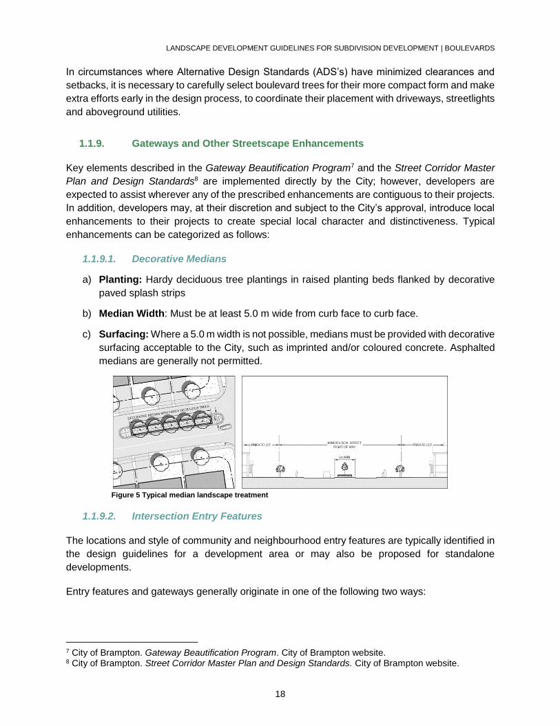
1.1.7. Window Roads
A “window road” is a local residential street with homes on one side and an arterial road on the
other.
a) Buffer Planting and Fencing: Typically have a 3.0 m of R.O.W. added to their standard
width where they abut the arterial road to allow for buffer planting and fencing.
b) Tree Species and Spacing: The emphasis should be on groups of conifers at 2.0 m - 3.0
m spacing to provide immediate visual screening.
c) Fence: A continuous 1.2 m high fence of decorative metal construction is required within
the buffer.
d) Walkway Openings: Typically provided in the fence at each end of the “window”
condition; these should be accented with decorative masonry columns.
Figure 4 Typical landscape treatment along a window road
1.1.8. Alternative Design Standards (ADS) for Roads
LANDSCAPE DEVELOPMENT GUIDELINES FOR SUBDIVISION DEVELOPMENT | BOULEVARDS
18
In circumstances where Alternative Design Standards (ADS’s) have minimized clearances and
setbacks, it is necessary to carefully select boulevard trees for their more compact form and make
extra efforts early in the design process, to coordinate their placement with driveways, streetlights
and aboveground utilities.
1.1.9. Gateways and Other Streetscape Enhancements
Key elements described in the Gateway Beautification Program7 and the Street Corridor Master
Plan and Design Standards8 are implemented directly by the City; however, developers are
expected to assist wherever any of the prescribed enhancements are contiguous to their projects.
In addition, developers may, at their discretion and subject to the City’s approval, introduce local
enhancements to their projects to create special local character and distinctiveness. Typical
enhancements can be categorized as follows:
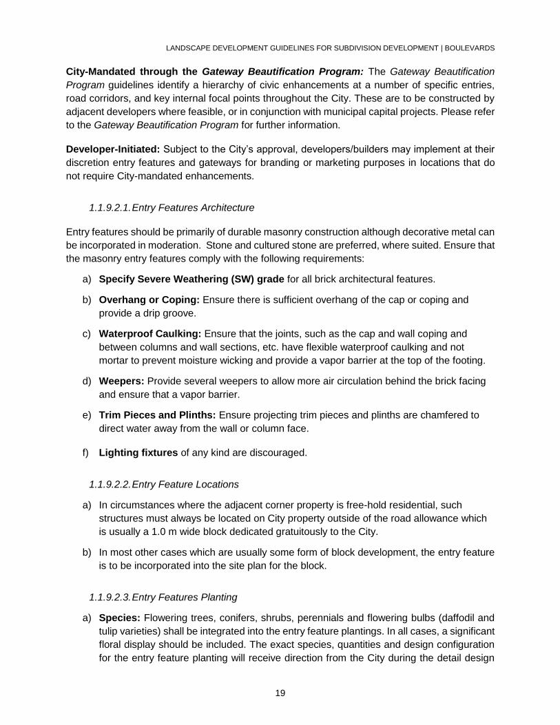
1.1.9.1. Decorative Medians
a) Planting: Hardy deciduous tree plantings in raised planting beds flanked by decorative
paved splash strips
b) Median Width: Must be at least 5.0 m wide from curb face to curb face.
c) Surfacing: Where a 5.0 m width is not possible, medians must be provided with decorative
surfacing acceptable to the City, such as imprinted and/or coloured concrete. Asphalted
medians are generally not permitted.
Figure 5 Typical median landscape treatment
1.1.9.2. Intersection Entry Features
The locations and style of community and neighbourhood entry features are typically identified in
the design guidelines for a development area or may also be proposed for standalone
developments.
Entry features and gateways generally originate in one of the following two ways:
7 City of Brampton. Gateway Beautification Program. City of Brampton website. 8 City of Brampton. Street Corridor Master Plan and Design Standards. City of Brampton website.
LANDSCAPE DEVELOPMENT GUIDELINES FOR SUBDIVISION DEVELOPMENT | BOULEVARDS
19
City-Mandated through the Gateway Beautification Program: The Gateway Beautification
Program guidelines identify a hierarchy of civic enhancements at a number of specific entries,
road corridors, and key internal focal points throughout the City. These are to be constructed by
adjacent developers where feasible, or in conjunction with municipal capital projects. Please refer
to the Gateway Beautification Program for further information.
Developer-Initiated: Subject to the City’s approval, developers/builders may implement at their
discretion entry features and gateways for branding or marketing purposes in locations that do
not require City-mandated enhancements.
1.1.9.2.1. Entry Features Architecture
Entry features should be primarily of durable masonry construction although decorative metal can
be incorporated in moderation. Stone and cultured stone are preferred, where suited. Ensure that
the masonry entry features comply with the following requirements:
a) Specify Severe Weathering (SW) grade for all brick architectural features.
b) Overhang or Coping: Ensure there is sufficient overhang of the cap or coping and
provide a drip groove.
c) Waterproof Caulking: Ensure that the joints, such as the cap and wall coping and
between columns and wall sections, etc. have flexible waterproof caulking and not
mortar to prevent moisture wicking and provide a vapor barrier at the top of the footing.
d) Weepers: Provide several weepers to allow more air circulation behind the brick facing
and ensure that a vapor barrier.
e) Trim Pieces and Plinths: Ensure projecting trim pieces and plinths are chamfered to
direct water away from the wall or column face.
f) Lighting fixtures of any kind are discouraged.
1.1.9.2.2. Entry Feature Locations
a) In circumstances where the adjacent corner property is free-hold residential, such
structures must always be located on City property outside of the road allowance which
is usually a 1.0 m wide block dedicated gratuitously to the City.
b) In most other cases which are usually some form of block development, the entry feature
is to be incorporated into the site plan for the block.
1.1.9.2.3. Entry Features Planting
a) Species: Flowering trees, conifers, shrubs, perennials and flowering bulbs (daffodil and
tulip varieties) shall be integrated into the entry feature plantings. In all cases, a significant
floral display should be included. The exact species, quantities and design configuration
for the entry feature planting will receive direction from the City during the detail design
LANDSCAPE DEVELOPMENT GUIDELINES FOR SUBDIVISION DEVELOPMENT | BOULEVARDS
20
stage. Limit trees, shrubs and perennials to 5 – 7 selections while ensuring a succession
of bloom and fall foliage colour.
b) Planting Scale and Proportion: Both flowering bulbs and perennial clusters shall be of
appropriate scale and proportion (minimum cluster size of 1 species or variety to be 2 sq.
m.).
c) Planting Arrangement: Avoid planting arrangements of many small planting clusters or
too many diverse species.
d) Planting Position: Ensure that the plant material position does not obstruct daylight
triangle sight lines and entry feature signage. Plantings should complement and not
obscure the architectural elements.
e) Irrigation: Some locations may require automated irrigation for entry feature planting beds
at the discretion of the City with irrigation system designs to be supplied and installed at
the developer’s expense.
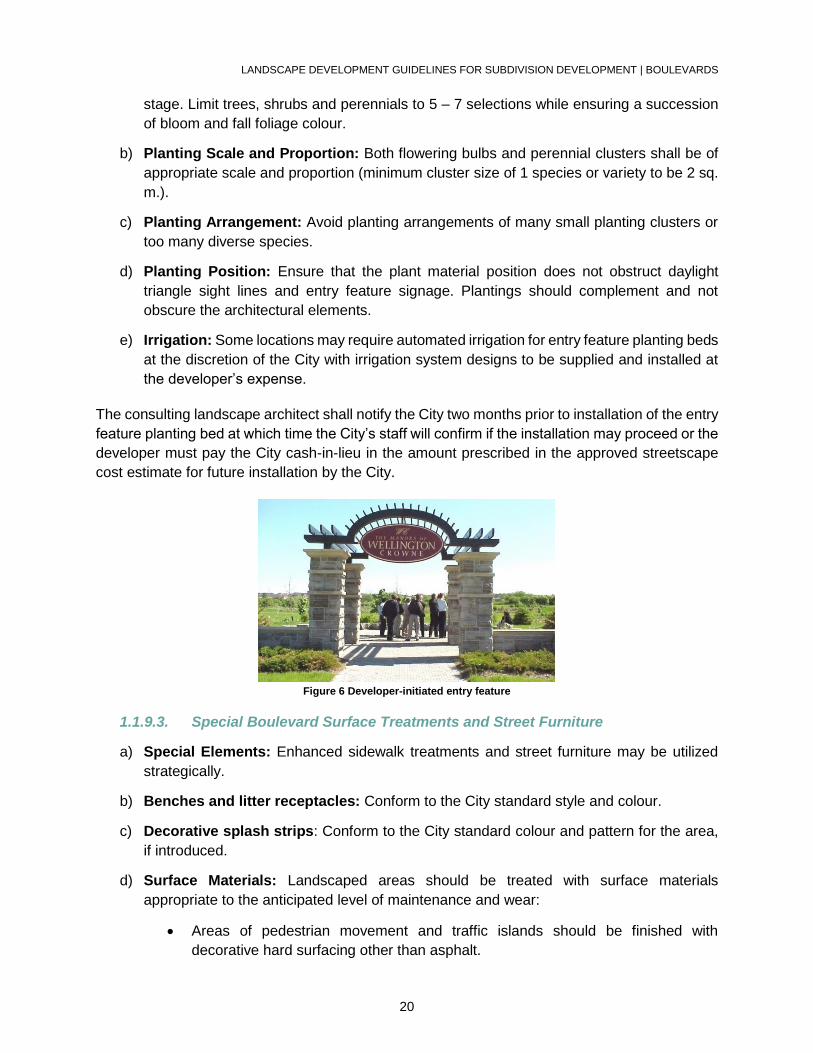
The consulting landscape architect shall notify the City two months prior to installation of the entry
feature planting bed at which time the City’s staff will confirm if the installation may proceed or the
developer must pay the City cash-in-lieu in the amount prescribed in the approved streetscape
cost estimate for future installation by the City.
Figure 6 Developer-initiated entry feature
1.1.9.3. Special Boulevard Surface Treatments and Street Furniture
a) Special Elements: Enhanced sidewalk treatments and street furniture may be utilized
strategically.
b) Benches and litter receptacles: Conform to the City standard style and colour.
c) Decorative splash strips: Conform to the City standard colour and pattern for the area,
if introduced.
d) Surface Materials: Landscaped areas should be treated with surface materials
appropriate to the anticipated level of maintenance and wear:
Areas of pedestrian movement and traffic islands should be finished with
decorative hard surfacing other than asphalt.
LANDSCAPE DEVELOPMENT GUIDELINES FOR SUBDIVISION DEVELOPMENT | PARK TYPOLOGY
21
Sodded or planted areas adjacent to intensively used pedestrian areas may need
to be protected with concrete edges or railings in some instances.
1.1.10. Boulevards Grading
Grading design should take into account both the intended use and the eventual maintenance
requirements of the area along with the need to assure soil stability.
a) Boulevards: Slopes for turf on boulevards may vary between 2% to 5%.
b) Buffers: Slopes for turf and mulched planting beds in buffers may vary between 2% - 33%
(3:1).
c) Hard Surfaces (other than pathways): Slope between 1% - 3%
1.2. PARK TYPOLOGY
1.2.1. City Parks
The City Parks within Brampton vary in size from 12 ha to 40 ha (30 acres to 100 acres). City
Parks are destinations for active recreation and focal points within the City. These parks are
intended to service the entire city. City parks are designed and constructed by the City.
1.2.2. Community Parks
Community Parks provide a range of opportunities for outdoor active and passive recreation that
is comparable to City Parks. They vary in size from 10 ha to 12 ha (25 acres to 30 acres) of active
tableland and are located in areas where the service area is able to accommodate 15,000 to
20,000 people within a 3.0 kilometre (1.86 mile) radius. Community parks are designed and
constructed by the City.
1.2.3. Neighbourhood Parks
1.2.3.1. General Requirements
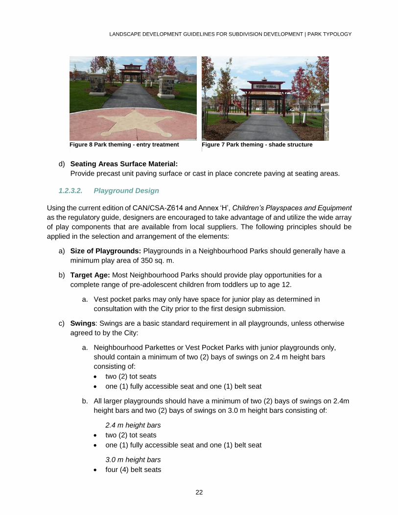
a) Theme or Character: Introduce variation in the appearance and function of the
Neighbourhood Parks by establishing a strong character or theme in the design of the
playground and other components such as paved areas, entry gate architecture and
other park accessories. Theming shall be incorporated in approximately 50% of the
parks as directed by the City.
b) Distinctive Elements: A landmark play component or a specific theme for a park that
makes the location memorable is encouraged. Examples of park themes: Animal
Kingdom, Pirate Ship, Western Town.
c) Creation of Functional Areas or “Rooms”: Use topography, planting and built form
where appropriate, to clearly define the functional areas or “rooms” of the park.
LANDSCAPE DEVELOPMENT GUIDELINES FOR SUBDIVISION DEVELOPMENT | PARK TYPOLOGY
22
d) Seating Areas Surface Material:
Provide precast unit paving surface or cast in place concrete paving at seating areas.
1.2.3.2. Playground Design
Using the current edition of CAN/CSA-Z614 and Annex ‘H’, Children’s Playspaces and Equipment
as the regulatory guide, designers are encouraged to take advantage of and utilize the wide array
of play components that are available from local suppliers. The following principles should be
applied in the selection and arrangement of the elements:
a) Size of Playgrounds: Playgrounds in a Neighbourhood Parks should generally have a
minimum play area of 350 sq. m.
b) Target Age: Most Neighbourhood Parks should provide play opportunities for a
complete range of pre-adolescent children from toddlers up to age 12.
a. Vest pocket parks may only have space for junior play as determined in
consultation with the City prior to the first design submission.
c) Swings: Swings are a basic standard requirement in all playgrounds, unless otherwise
agreed to by the City:
a. Neighbourhood Parkettes or Vest Pocket Parks with junior playgrounds only,
should contain a minimum of two (2) bays of swings on 2.4 m height bars
consisting of:
two (2) tot seats
one (1) fully accessible seat and one (1) belt seat
b. All larger playgrounds should have a minimum of two (2) bays of swings on 2.4m
height bars and two (2) bays of swings on 3.0 m height bars consisting of:
2.4 m height bars
two (2) tot seats
one (1) fully accessible seat and one (1) belt seat
3.0 m height bars
four (4) belt seats
Figure 8 Park theming - entry treatment Figure 7 Park theming - shade structure

LANDSCAPE DEVELOPMENT GUIDELINES FOR SUBDIVISION DEVELOPMENT | PARK TYPOLOGY
23
c. Saucer swings are encouraged as an excellent alternative to some or all of the
conventional swings, particularly where space is limited.
d) Other Playground Components:
a. Incorporate a significant number of moving components (in addition to swings,
spring toys and play panels) into every playground with a minimum of two (2) in
every layout.
b. Emphasize mobile overhead components such as slide bars and spinning
wheels, and ground level mobile components, such as rocking logs and spinning
platforms.
c. A dedicated sand play area with an active play component of a digger or sand
table is strongly encouraged, provided it is contained by a formed concrete curb
or other approved edging material, depending on design.
e) Playground Accessibility:
a. Provide a number of accessible play components in every playground.
Designers are required to meet or exceed the Annex H addition to CAN/CSA-
Z614 to provide increased accessibility and opportunities. The accessible ramp
shall be located in close proximity to the accessible play components.
b. Prior to the initiation of detailed design, selected playgrounds, may from time-to-
time be designated by the City as “fully accessible”. In such cases, special
efforts will be required by the designer to make the playground equally
challenging for children of all capabilities while working within the budgetary
limitations of the project.
f) Avoid:
a. Avoid excessive use of stairs, platforms and multiple slides on the same structure
and introduce more challenging and varied play components.
b. Avoid using tube slides.
g) Playground Surface Material: Engineered wood fiber is the preferred surfacing
material for playgrounds; however, rubberized play surfacing may also be used in limited
locations as agreed to by the City.
a. Provide appropriate playground surfaces with sub-drain system connected to the
nearest storm sewer. Contain the playground surface material by a formed
concrete curb or other approved edging material, depending on design.
1.2.3.3. Local Parks
a) Size: 1.2 ha to 2 ha (3 acres to 5 acres).
b) Purpose: Intended for spontaneous recreational opportunities (no programming).
c) Potential Elements: The City, at its discretion, may on a site specific basis add a formal
mini-soccer or softball field with a small parking lot which would require the maximum 2
LANDSCAPE DEVELOPMENT GUIDELINES FOR SUBDIVISION DEVELOPMENT | PARK TYPOLOGY
24
ha (5 acre) size under this classification. May include, but is not limited to: a playground,
multi-purpose court, seating areas, walkways, lighting, shade structures, open active
area, landscaping, floral displays, buffer areas and/or natural or cultural features.
1.2.3.4. Town Squares
a) Size: 0.6 to 1.5 hectares (1.5 to 3.7 acres)
b) Purpose: Located in neighborhoods to accommodate 4,000 to 5,000 people within a 0.4
kilometer (1/4 mile) radius for active and passive recreation.
c) Potential Elements: May include, but is not limited to: a playground, multi-purpose court,
seating areas, walkways, lighting, shade structures, open active area, landscaping, floral
displays, buffer areas and/or natural or cultural features. Note: parks less than 0.5
hectares are only provided in exceptional cases and special situations.
1.2.3.5. Vest Pocket Parks
a) Size: 0.4 ha to 0.6 ha (1.0 acre to 1.5 acres)
b) Purpose: Utilized most often to provide modest facilities in under-serviced areas between
the larger parks or introduced to create a special neighbourhood focal point, recreational
trailhead or point of entry into a woodland or similar open space.
c) Potential Elements: Structured facilities are generally limited to a sitting area and a
junior playground if needed.
1.2.3.6. Urban Parks
a) Size and Purpose: Urban Parks are smaller specialized parks that are most suitable
within the City’s higher density urban areas or in underserviced areas where the
acquisition of larger parks is not possible.
b) Potential Elements: May include informal and formal playgrounds, seating areas, more
intensive hardscape elements, public art, and unstructured green space. The type,
number and scale of facilities within these parks should be determined on a case-by-case
basis. In certain instances, these parks may be located in private spaces that provide for
public access.
1.2.3.7. Linear Connectors
a) Lands that are oriented to off-road recreational trails and/or connecting links between
other forms of parkland or major community destinations.
1.2.4. Sports Facilities
a) Location and Size: Sports fields will typically be limited to City and community parks
and to very selective locations in Neighbourhood Parks that are larger than 4 acres.
LANDSCAPE DEVELOPMENT GUIDELINES FOR SUBDIVISION DEVELOPMENT | PARK TYPOLOGY
25
b) Design, Orientation, Setbacks and Construction: Shall conform to the Parks
Construction Standard Details9 and Landscape Specifications10.
c) Setbacks of Facilities from Residential Property Lines: 20.0 m for unlit facilities and
30.0 m for illuminated sport fields.
d) Setbacks of Swales, Berms and Catch Basins: No closer than a minimum of 6.0 m
from light poles.
e) Setback of Plantings: 10.0 m from sports field lighting.
f) Sports Field Grading: All sports fields shall be graded with a crown and sloped a 1.5%
minimum, except artificial turf or formal fields (which have specific design and engineering
requirements) or sand based fields with subdrains and irrigation.
g) Vehicular Maintenance Route: Provide a 6.0 m wide vehicular maintenance route
around the field perimeter to allow access to the light poles. The vehicular maintenance
route grading shall not exceed 5%.
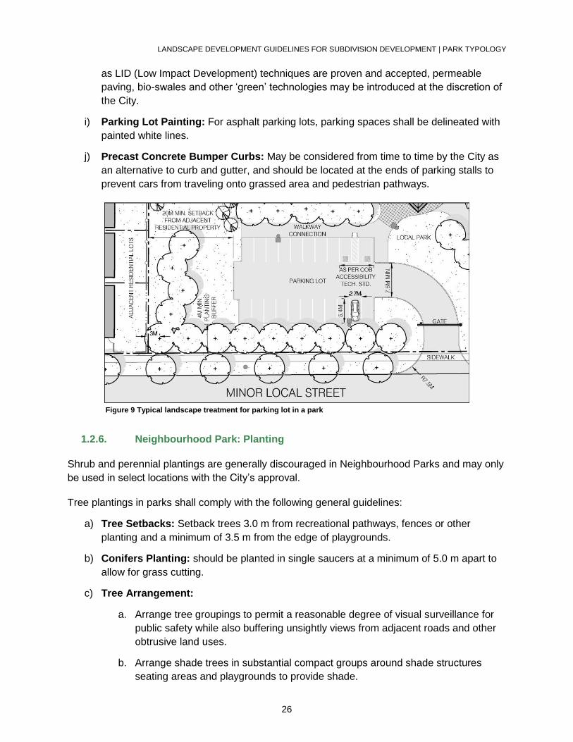
1.2.5. Neighbourhood Park: Parking
a) Parking Lot Location: Generally, parking lots will only be located where there are
sports fields or some other community facility that is considered a higher volume “drive
to”’ destination.
b) Parking Lot Screening: Parking lots should be screened from adjacent streets and
residences with plant material while allowing adequate opportunities for visual
surveillance from surrounding streets.
c) Separation Distance from Road Property Line: Minimum 4.0 m separation distance
should be provided from the road property line to edge of the parking lot.
d) Setback from Residential Properties: A minimum 20.0 m setback is recommended for
all parking lots from adjacent residential properties.
e) Parking Lot Pathway Connection: Parking lots should be connected to the asphalt
recreational pathway system within the park.
f) Parking Lot Measurements: Stall sizes shall be 2.7 m wide by 5.4 m long. Aisle widths
will be 6.6 m wide. The access road from the municipal street to the first parking lot stall
will be minimum 7.5 m wide. The radius of concrete curb at the road will be minimum 7.5
m.
g) Handicapped Parking Spaces: Shall be provided at the rate of one per field and in
accordance with the Accessibility Technical Standards.
h) Parking Lot Surfacing and Drainage: Generally, parking lots should be surfaced with
asphalt paving and drained internally using curb and gutter with catch basins; however,
9 City of Brampton. Parks Construction Standard Details. City of Brampton website. 10 City of Brampton. Landscape Specifications. City of Brampton website.
LANDSCAPE DEVELOPMENT GUIDELINES FOR SUBDIVISION DEVELOPMENT | PARK TYPOLOGY
26
as LID (Low Impact Development) techniques are proven and accepted, permeable
paving, bio-swales and other ‘green’ technologies may be introduced at the discretion of
the City.
i) Parking Lot Painting: For asphalt parking lots, parking spaces shall be delineated with
painted white lines.
j) Precast Concrete Bumper Curbs: May be considered from time to time by the City as
an alternative to curb and gutter, and should be located at the ends of parking stalls to
prevent cars from traveling onto grassed area and pedestrian pathways.
Figure 9 Typical landscape treatment for parking lot in a park
1.2.6. Neighbourhood Park: Planting
Shrub and perennial plantings are generally discouraged in Neighbourhood Parks and may only
be used in select locations with the City’s approval.
Tree plantings in parks shall comply with the following general guidelines:
a) Tree Setbacks: Setback trees 3.0 m from recreational pathways, fences or other
planting and a minimum of 3.5 m from the edge of playgrounds.
b) Conifers Planting: should be planted in single saucers at a minimum of 5.0 m apart to
allow for grass cutting.
c) Tree Arrangement:
a. Arrange tree groupings to permit a reasonable degree of visual surveillance for
public safety while also buffering unsightly views from adjacent roads and other
obtrusive land uses.
b. Arrange shade trees in substantial compact groups around shade structures
seating areas and playgrounds to provide shade.
LANDSCAPE DEVELOPMENT GUIDELINES FOR SUBDIVISION DEVELOPMENT | PARK TYPOLOGY
27
c. Arrange conifers in compact groups on the most wind-exposed sides of the same
areas.
d) Tree Density: Trees will be planted at a density of 120 trees per hectare (i.e. 50 trees
per acre).
All planting is to be supplied and installed in accordance with the Parks Construction Standard
Details.11
1.2.7. Neighbourhood Park: Site Grading
a) Grading Design: Grading design should take into account both the intended use and the
eventual maintenance requirements of the area along with the need to assure soil stability.
Slopes may vary as follows:
Turf or mulched planting beds associated with open play areas in parks: 2% -
5%
Turf and mulched planting beds elsewhere in parks: maximum 25% (4:1)
Areas surrounding the playground edge: minimum 2% slope.
Hard Surfaces (other than pathways): 1% - 3%
b) Berms: Ensure that berms do not negatively affect or eliminate flat open play areas.
Berms should be substantial enough to provide significant additional recreational value,
such as an effective small toboggan hill.
c) Play Slopes: Utilize and accentuate natural grade changes where possible to create
play slopes for summer and winter (maximizing north and east-facing slopes for winter).
d) Park Drainage: Should be internal to the extent practicable by directing surface runoff to
catch basins within the park. Drainage onto adjacent private lands is not permitted.
Drainage onto parkland from adjacent lands and overland flow routes across parkland are
not permitted unless prior written approval has been received from the City.
The consultant shall verify that grading plans are correct and that site grading conforms to the
grading plan. Ponding and poorly drained areas will not be accepted.
1.2.8. Neighbourhood Park: Site Furniture
a) Seating Locations: As specified in the City standard detail no. L876 (refer to the Parks
Construction Standard Details), standard benches are to be provided in tableland parks
adjacent to playgrounds and other selected locations.
b) Seating Positioning: Orient seating areas toward the play area with space for bicycle
racks, benches, and trash receptacles. Standard benches should generally be
positioned adjacent to pathways on a separate concrete pad but in special
circumstances may also be located away from pathways on grass or mulched surfaces.
11 City of Brampton. Parks Construction Standard Details. City of Brampton website.
LANDSCAPE DEVELOPMENT GUIDELINES FOR SUBDIVISION DEVELOPMENT | PARK TYPOLOGY
28
c) Trash Receptacles: Should be located near benches, shade structures and pathway
intersections. A separation of 5.0m is desired between site furniture and trash
receptacles to avoid wasps.
d) Park Identification Signs: Should be located strategically along major road frontages
and at the primary entrance(s) into the park block. The City shall supply all signs to the
contractor for installation during the park construction or at any time prior to Preliminary
Acceptance of the site.
1.2.9. Neighbourhood Park: Shade Structures
The following design guidelines shall be considered when including shade structures in any park.
Deviations may be considered in response to a specific design theme that is being promoted in
the immediate development or block plan area. Refer to Parks Construction Standard Details
L800 to L803.
1.2.9.1. Shade Structure Proportions, Shape and Size
a) Minor Structure 6.0 m nominal (20’): May be octagonal or square in shape. Refer to City
Standard Detail No. L800 in the Parks Construction Standard Details for further
information related to the shade structure proportions.
b) Major Structures 6.0 m x 9.0 m nominal (20’ x 30’): Typically used in larger
Neighbourhood Parks and Community Parks. Major structures sized 6.0 m x 12.0 m (20’
x 40’) are typically implemented in Community and City Parks.
c) Picnic Shelters: Should be rectangular in shape and approximately 6.0 m x 12.0 m
nominal (20’ x 40’).
1.2.9.2. Shade Structure Flooring
a) Surfacing: Floors should be concrete (minimum 100 mm thick) with a broom finish and
Brampton “Heritage” colour pigment. Other low maintenance floor surfaces, such as unit
pavers on concrete base or imprinted concrete, will be considered if the design context
justifies it.
1.2.9.3. Shade Structure Colour and Materials
a) Shade Structure Colours: Can be site-specific and complement surrounding
development or park colour schemes.
b) Preferred Materials: Metal is preferred, however, cedar shingle roofs may also be
considered. All vertical or inclined steel components such as posts and beams, shall be
hot-dipped galvanized and painted.
1.2.9.4. Shade Structure Lighting and Electrical
LANDSCAPE DEVELOPMENT GUIDELINES FOR SUBDIVISION DEVELOPMENT | NATURAL HERITAGE
29
a) Luminaire: All shade structures shall include a luminaire with a wire guard as per the
Parks Lighting Guidelines12.
b) Cables and Conduit: shall be routed inside the structural components of the shade
structure to the luminaire.
c) Outlets: All shade structures shall include an electrical outlet in a lockable box as per the
Parks Lighting Guidelines13.
1.2.9.5. Shade Structure Accessibility
a) All shade structures shall be completely accessible as per the Accessibility Technical
Standards14.
1.2.10. Neighbourhood Park: Lighting
Please refer to the Parks Lighting Guidelines for further information.
1.2.11. Neighbourhood Park: Fencing
All fencing shall be supplied and installed in accordance with the Parks Construction Standard
Details.
Please refer to Appendix C: Subdivision and Site Plan Fencing and Wall Standards for fencing
and noise attenuation requirements.
1.3. NATURAL HERITAGE
1.3.1. Valleylands
a) Valleylands are to be left in their natural state for the most part except for the
installation of recreational trails and bridge crossings that are prescribed in the Brampton’s
PathWays Master Plan15 and/or approved Community Design Guidelines.
b) Passive recreation such as walking, cycling and bird watching are also supported by
unobtrusive interpretive and way-finding signage, sitting areas and lookouts.
c) Where significant alterations are made to valleyland, restoration plans will demonstrate
a net ecological gain to the satisfaction of the City, and the applicable Conservation
Authority.
12 City of Brampton. Parks Lighting Guidelines. City of Brampton website. 13 City of Brampton. Parks Lighting Guidelines. City of Brampton website. 14 City of Brampton. Accessibility Technical Standards. City of Brampton website. 15 City of Brampton. Brampton’s PathWays Master Plan. City of Brampton website.
LANDSCAPE DEVELOPMENT GUIDELINES FOR SUBDIVISION DEVELOPMENT | NATURAL HERITAGE
30
1.3.1.1. Access and Linkages
a) Recreational Trail Location: Recreational trails shall typically be located to avoid the
root systems of mature trees and through areas of less sensitive vegetation. Areas with
steep slopes or seasonally wet conditions must be described.
b) Recreational Trail Surfaces: Alternative recreational trail surface materials (i.e.
granular, wood chip) may be considered in lieu of asphalt for use in areas with shallow
roots, organic soils, or with seasonally ponded conditions if alternative recreational trail
locations are not feasible.
c) Elimination and Rehabilitation of Undesirable Recreational Trails: General
measures to eliminate and rehabilitate undesirable recreational trails and hazardous
conditions shall be implemented.
d) Wayfinding and Regulatory Signage: Shall be provided to identify intended use of
recreational trail, level of maintenance to be provided, and applicable bylaws.
e) Gates: No gates shall be installed that provide direct access to the valleyland from the
residential lots.
1.3.1.2. Invasive Species
a) Invasive Species that detract from biological diversity and inhibit pedestrian movement
in woodlands shall be controlled. All invasive species deemed hazardous to the public,
at the top of bank and in valley lands shall be removed.
b) Herbaceous Species: Shall be controlled by repeated pulling of plants prior to seed set.
Certain conditions may require control with an approved herbicide.
c) Woody Species: Shall be controlled by trimming flush to the ground followed by
treatment of the stubs with an approved herbicide.
d) Severe Infestations: In areas with severe infestations, canopy and soil management
may be required to alter environmental conditions of the woodland.
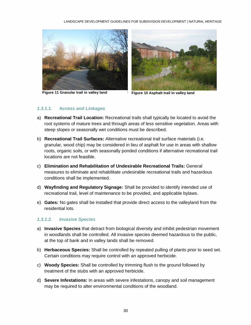
Figure 10 Asphalt trail in valley land Figure 11 Granular trail in valley land
LANDSCAPE DEVELOPMENT GUIDELINES FOR SUBDIVISION DEVELOPMENT | NATURAL HERITAGE
31
1.3.1.3. Habitat Enhancement
a) Dead or Decaying Trees: Preserve large standing dead or decaying trees that do not
present a hazard to pedestrians. All dead wood and trees/limbs deemed hazardous to
the public, at the top of bank and in valley lands shall be removed.
b) Native Coniferous Species: Planting nodes of native coniferous species along
valleyland edges is desirable.
c) Fallen Trees: The disposal of fallen trees by cutting them into 2 m to 3 m long logs and
placing them in secure locations where they do not endanger pedestrians is desirable in
small quantities.
d) Brush: Small quantities of brush may be placed in piles not to exceed 0.9 m in height
and min. 1.5 m from edge of recreational trail.
e) Bird Houses and Bat Roosts: The provision of bird houses and bat roosts in strategic
locations is desirable.
1.3.1.4. Restoration Planting
a) Restoration Planting: Shall be required where tree cover is to be restored.
b) Restoration Planting Species: All restoration planting shall consist of native species
and shall be selected appropriately for the given soil, moisture, and light conditions of
the site, as well as any specific stresses.
c) Restoration Tree Planting Ratio: A planting ratio of 40% caliper trees (30 mm to 70
mm) and 60% tree whips (1.0 m to 2.0 m) shall be provided.
d) Restoration Tree Planting Densities: A planting density of 10 trees per 100 m2 shall
be provided, based on the aforementioned mix of caliper trees and whips.
e) Groundcover Restoration: Restoration plantings of groundcovers shall utilize
regeneration from seedbank, or may be seeded with a nurse crop of low maintenance
grasses if seedbank is unavailable.
f) Sodding: Restoration planting areas shall not be sodded.
1.3.1.5. Environmental Buffer
a) Plant selection: Select native plant materials that is appropriate for existing site
conditions and to maximize ecological function.
b) Total Quantity of Plant Material: Use the following formula to calculate the total
quantity of plant material.
Number of shrubs = square area of buffer divided by 9.0 sq. m.
Number of trees = square area of buffer divided by 36.0 sq. m.
1.3.2. Woodlands
LANDSCAPE DEVELOPMENT GUIDELINES FOR SUBDIVISION DEVELOPMENT | NATURAL HERITAGE
32
All woodlands located on tableland areas are to be evaluated pursuant to the policies of the City
of Brampton Official Plan16. Woodlands are to be left in their natural state except for the installation
of pathways required to facilitate a recreational trail system. Refer to the Woodland Management
Plan Guidelines17 for further details.
A Woodland Development and Restoration Plan shall be completed for each woodland block
which will detail the short term management measures as per the recommendations of the
Woodland Management Plan.
The following describes the general requirements with respect to woodland management:
1.3.2.1. General Requirements
a) Runoff: Runoff from re-graded development areas shall not be permitted to flow directly
into woodlands.
b) Hoarding: Temporary hoarding shall be installed in accordance with City standard detail
no. L110 and shall be erected prior to the issuance of the topsoil stripping and grading
permit.
c) Fencing: Permanent fencing shall be installed in accordance with Appendix C:
Subdivision and Site Plan Fencing and Wall Standards.
1.3.2.2. Pedestrian Access and Linkages
a) Recreational Trail Location: Recreational trails shall typically be located to avoid the
root systems of mature trees and through areas of less sensitive vegetation. Areas with
steep slopes or seasonally wet conditions must be described.
b) Surfaces: Alternative surface materials (i.e. granular, wood chip) may be considered in
lieu of asphalt for use in areas with shallow roots, organic soils, or with seasonally
ponded conditions if alternative trail locations are not feasible.
c) Elimination and Rehabilitation of Undesirable Recreational Trails: General
measures to eliminate and rehabilitate undesirable recreational trails and hazardous
conditions shall be implemented.
d) Wayfinding and Regulatory Signage: Shall be provided to identify intended use of
recreational trail, level of maintenance to be provided and applicable bylaws.
e) Gates: No gates shall be installed that provide direct access to the woodland from the
residential lots.
1.3.2.3. Conservation of Biotic Resources
16 City of Brampton. City of Brampton Official Plan. City of Brampton website. 17 City of Brampton. Woodland Management Plan Guidelines. City of Brampton website.
LANDSCAPE DEVELOPMENT GUIDELINES FOR SUBDIVISION DEVELOPMENT | NATURAL HERITAGE
33
Existing biotic (living) resources associated with the woodland (e.g.: topsoil, seedbank, plant
material, etc.) which are displaced by development shall be reused wherever possible on the
same project, or made available to the City for use in other such projects.
1.3.2.4. Restoration Planting
a) Restoration Planting: Shall be required where forest cover is to be restored.
b) Restoration Planting Species: All restoration planting shall consist of native species
and shall be selected appropriately for the given soil, moisture, and light conditions of
the site, as well as any specific stresses.
c) Restoration Tree Planting Density: Restoration efforts within a woodland will achieve
a minimum tree density of 1000 stems per hectare, in accordance with the definition of a
Woodlot as described in the City’s Woodlot Conservation By-law. This density will be
calculated using existing and proposed restoration planting.
d) Restoration Tree Planting Ratio: A planting ratio of 40% caliper trees (30 mm – 70
mm) and 60% tree whips (1.0 m to 2.0 m) shall be provided.
e) Groundcover Restoration: Restoration plantings of groundcovers shall utilize
regeneration from seedbank, or may be seeded with a nurse crop of low maintenance
grasses if seedbank is unavailable.
f) Sodding: Restoration planting areas shall not be sodded.
1.3.2.5. Woodlot Edge Re-Establishment
a) Edge Re-Establishment: shall be required where an existing edge is disturbed by
development (e.g.: grade changes, etc.) or to protect sensitive interior areas from post-
development conditions.
b) Edge-Reestablishment Species: All tree, shrub and ground cover species shall reflect
the native species present in the adjoining woodland.
c) Edge-Reestablishment Groundcovers: Shall utilize regeneration from seedbank, or
may be seeded with a nurse crop of rye grass.
d) Sodding: Woodland edge re-establishment areas shall not be sodded.
1.3.2.6. Invasive Species
a) Invasive Species that detract from biological diversity and inhibit pedestrian movement
in woodlands shall be controlled. All invasive species deemed hazardous to the public,
at the top of bank and in woodlands shall be removed.
b) Herbaceous Species: Shall be controlled by repeated pulling of plants prior to seed set.
Certain conditions may require control with an approved herbicide.
c) Woody Species: Shall be controlled by trimming flush to the ground followed by
treatment of the stubs with an approved herbicide.
LANDSCAPE DEVELOPMENT GUIDELINES FOR SUBDIVISION DEVELOPMENT | NATURAL HERITAGE
34
d) Severe Infestations: In areas with severe infestations, canopy and soil management
may be required to alter environmental conditions of the woodland.
1.3.2.7. Habitat Enhancement
a) Dead or Decaying Trees: Preserve large standing dead or decaying trees that do not
present a hazard to pedestrians. All dead wood and trees/limbs deemed hazardous to
the public, at the top of bank and in woodlands shall be removed.
b) Native Coniferous Species: Planting nodes of native coniferous species along
woodland edges is desirable.
c) Fallen Trees: The disposal of fallen trees by cutting them into 2 to 3m long logs and
placing them in secure locations where they do not endanger pedestrians is desirable in
small quantities.
d) Brush: Small quantities of brush may be placed in piles not to exceed 0.9 m in height
and min. 1.5 m from edge of recreational trail.
e) Bird Houses and Bat Roosts: The provision of bird houses and bat roosts in strategic
locations is desirable.
1.3.2.8. Environmental Buffer
g) Buffer Planting Species: Shall consist of native species and selected appropriately for
the given soil, moisture, and light conditions of the site, as well as any specific stresses.
h) Buffer Tree Planting Density: Planting in woodland buffers will achieve a minimum tree
density of 1000 stems per hectare, in accordance with the definition of a Woodlot as
described in the City’s Woodlot Conservation By-law.
i) Buffer Tree Planting Ratio: A planting ratio of 40% caliper trees (30 mm – 70 mm) and
60% tree whips (1.0 m to 2.0 m) shall be provided.
j) Groundcover Restoration: Restoration plantings of groundcovers shall utilize
regeneration from seedbank, or may be seeded with a nurse crop of low maintenance
grasses if seedbank is unavailable.
1.3.3. Wetlands
1.3.3.1. Access and Linkages
a) Recreational Trail Location: Recreational trails shall typically be located to avoid areas
of sensitive vegetation. Areas with steep slopes or seasonally wet conditions must be
described.
b) Surfaces: Alternate types of surfaces (i.e. granular, wood chip) will be considered in lieu
of asphalt for use in areas with shallow roots, organic soils, or with seasonally ponded
conditions if alternative recreational trail locations are not feasible.
LANDSCAPE DEVELOPMENT GUIDELINES FOR SUBDIVISION DEVELOPMENT | STORMWATER MANAGEMENT FACILITIES
35
c) Elimination and Rehabilitation of Undesirable Recreational Trails: General
measures to eliminate and rehabilitate undesirable recreational trails and hazardous
conditions shall be implemented.
d) Wayfinding and Regulatory Signage: Shall be provided to identify intended use of
recreational trail, level of maintenance to be provided and applicable bylaws.
e) Gates: No gates shall be installed that provide direct access to the wetland from the
residential lots.
1.3.3.2. Invasive Species
a) Invasive Species that detract from biological diversity and inhibit pedestrian movement
in wetlands shall be controlled. All invasive species deemed hazardous to the public, at
the top of bank and in wetlands shall be removed.
b) Herbaceous Species: Shall be controlled by repeated pulling of plants prior to seed set.
Certain conditions may require control with an approved herbicide.
c) Woody Species: Shall be controlled by trimming flush to the ground followed by
treatment of the stubs with an approved herbicide.
d) Severe Infestations: In areas with severe infestations, canopy and soil management
may be required to alter environmental conditions of the wetland.
1.3.3.3. Restoration Planting
a) Restoration Planting: Shall be required where determined by an Environmental Impact
Study (EIS).
b) Restoration Planting Species: All restoration planting shall consist of native species
and shall be selected appropriately for the given soil, moisture, and light conditions of
the site, as well as any specific stresses, in accordance with the recommendations of the
Environmental Impact Study (EIS).
1.3.3.4. Environmental Buffer
a) Buffer Planting Species: Shall consist of native species and selected appropriately for
the given soil, moisture, and light conditions of the site, as well as any specific stresses,
in consultation with the Conservation Authority.
b) Buffer Planting Density: The entire wetland buffer will be planted with appropriate
vegetation, in consultation with the Conservation Authority.
1.4. STORMWATER MANAGEMENT FACILITIES
It is expected that every effort will be made to integrate stormwater management (SWM) facilities
into their neighbourhoods by ensuring that they meet the following general guidelines:
LANDSCAPE DEVELOPMENT GUIDELINES FOR SUBDIVISION DEVELOPMENT | STORMWATER MANAGEMENT FACILITIES
36
a) Street Frontages: Should have street frontages on at least two sides.
b) Landscaping: Should take advantage of the water as an additional visual asset.
c) Connections: Should be combined with other public open space wherever practicable.
Should also provide locations for community and neighbourhood gateways when these
are desired.
d) Natural Habitat: Should provide viable natural habitat that is acceptable in close proximity
to residential properties.
e) Grading and Drainage: SWM for parkland must comply with the Master Drainage Plan
for the development where applicable.
a. All internal storm drainage fixtures shall conform to the Public Works and
Engineering Department standards.
b. Parkland in conjunction with school sites or stormwater management facilities
should be graded as one continuous drainage area to the extent that is practicable.
SWM ponds must be designed to facilitate ease of access for maintenance vehicles for periodic
cleanout. Views, vistas and architectural features such as shade structures, raised viewing
platforms, lookouts and fountains may be incorporated into the design to accentuate the
stormwater management facilities as community gateways and focal points in naturalized open
spaces. These proposed features would be dependent on pond size, location, and visibility from
the adjacent public streets.
1.4.1. Pedestrian Access and Linkages
Although public use of SWM pond sites is not promoted by the City, it is recognized that residents
make use of them for passive recreation.
a) General Access: Allow for limited safe public access (but no water contact).
b) Lookouts: Plant material is to be situated to provide thickets adjacent to the waterline to
discourage access to the water in locations other than proposed lookouts and to continue
access by geese.
c) Recreational Trail Surfacing: Maintenance access routes are used as local recreational
trail loops and accordingly, they are to be provided with a limestone surface.
d) Recreational Trails: A continuous recreational trail shall be constructed around the SWM
pond and shall adhere to the following criteria:
a. Minor recreational trails shall be:
2.4 m wide with a 0.5 m sod buffer on both sides of the recreational trail;
Constructed of limestone screenings; and
Located at a minimum height of 0.3 m above the 5-year predicted water level.
LANDSCAPE DEVELOPMENT GUIDELINES FOR SUBDIVISION DEVELOPMENT | STORMWATER MANAGEMENT FACILITIES
37
b. Major recreational trails (which form part of the City’s recreational trail system)
shall be:
3.0 m wide with a 0.5 m sod buffer on both sides of the trail;
Constructed of asphalt;
Located at a minimum height of 0.3 m above the regulatory storm event; and
Located 1.0 m away from the pond embankment.
The maintenance access road may facilitate the recreational trail; however, it shall be located a
minimum of 3.0 m away from the property line, where they abut residential properties. Please
refer to the Subdivision Design Manual 18 for further information related to the design of
stormwater management facilities.
1.4.2. Planting
The balance of the land around the pond should be established as naturalized meadow
interspersed with groups of coniferous and deciduous trees that allow for and frame views of the
pond from the adjacent streets and private property. Special care should be taken at the design
stage to ensure that plants will not block attractive views of the pond as they mature.
The following are general notes about the planting scheme that are to be taken into account when
designing a facility:
a) Planting Setback: Minimum setbacks for planting from the maintenance access road
adjacent to the forebay are 3.0 m for caliper trees and conifers and 3.0 m for shrubs.
b) Planting Bed along Water Edge: A continuous planting bed with dense plant material
should surround the entire water edge of the pond to deter geese from accessing the
water.
c) Planting Bed Boundaries: Planting beds should be well defined such as to facilitate
mowing equipment to operate between them. A minimum distance of 3.0 m is required
between plant bed edges and trees or other obstacles.
d) Trees in Planting Beds: Trees should be grouped inside plant beds or in well-defined
clusters allowing mowing equipment to operate around them.
e) Mulch in Planting Beds: Continuous mulched planting beds shall be provided
immediately below the maintained tableland areas. These continuous beds shall only be
interrupted where a maintenance access road or pathway access is required.
f) Location of Planting: Planting should not occur in areas designated for sediment
storage.
g) Plant Species:
18 City of Brampton. Subdivision Design Manual. City of Brampton website.
LANDSCAPE DEVELOPMENT GUIDELINES FOR SUBDIVISION DEVELOPMENT | STORMWATER MANAGEMENT FACILITIES
38
a. The ratio between deciduous trees and coniferous trees should be approximately
60 /40.
b. Deciduous Trees: A variety of hard and soft deciduous trees such as Silver
Maple, Bur and Red Oak, White and Green Ash, Mountain Ash, Black Cherry,
Balsam Poplar, Pignut Hickory, Basswood and Trembling Aspen should be
provided.
Sizes: Deciduous tree plantings should consist of the minimum percentage
sizes as noted: 150 cm - 30%; 300 cm, 40 mm & 60 mm caliper - 20% each
(combined total of 60%); and 70 mm caliper - 10%.
c. Coniferous Trees: A variety of coniferous trees such as White Spruce, Eastern
White Cedar and White and Red Pine should be provided.
Sizes: Conifer tree plantings should consist of the minimum percentage sizes
as noted: 100 cm - 40%; 150 cm - 50%; and 200 cm - 10%.
d. Shrub varieties such as Red Osier, Gray and Alternate Leaved Dogwoods,
Nannyberry, Serviceberry, Chokecherry, Bush Honeysuckle, Elderberry,
Highbush Cranberry, Pussy, Sandbar, Bebb’s, Peach-leaved and Black Willow,
Hawthorne, Staghorn Sumac, and Snowberry can provide a range of mature
heights, textures and seasonal colour.
Sizes: Shrub plantings should consist of the minimum sizes: 40 cm - 30%; 60
cm - 40%; and 80 cm - 30%.
e. Aquatic plants range between emergent, submergent, and floating types based
on their location within the pond.
Emergent Plants: Cattail, Narrow-leaved bulrush, Arrowhead, Plantain,
Burrweed and various grasses and sedges. Cattails should be planted down-
wind to avoid spreading quickly throughout the pond.
Submergent Plants: May be introduced where depths are appropriate for
varieties such as Canada, Waterweed, and Curly Pondweed.
Floating Species: Floating species such as Bullhead Lily should be planted
on the leeward side of the pond for wind protection (where depths are
appropriate).
f. Total Quantity of Plant Material: The following formula should be applied for
calculating the total quantity of plant material. The densities were developed
based on the total stormwater management pond area subtracting the permanent
“wet” pond area resulting in a remaining total “dry” pond area including the area
of maintenance roads and sediment storage areas:
Number of shrubs = square area of “dry” pond divided by 9.0 sq. m.
Number of trees = square area of “dry” pond divided by 36.0 sq. m.
Number of aquatic plants = based on linear length in meters of water’s edge x
1.0 m width x 0.5 m centres
Refer to the Subdivision Design Manual for additional details.
LANDSCAPE DEVELOPMENT GUIDELINES FOR SUBDIVISION DEVELOPMENT | TABLELAND TREES
39
1.4.3. Safety Stations and Warning Signage
a) Safety Stations: In an effort to provide the highest level of safety on public sites bordering
on or containing ponds and waterways, safety stations along the water edges of such
locations shall be provided.
a. Developers are required to install the safety station in accordance with City
standard detail no. L850 (refer to the Parks Construction Standard Details) as a
developer cost item.
b. The safety station pole and all associated hardware and accessories will be
provided to the developer by the City at no cost and the developer will be required
to provide installation services for the stations only.
b) Warning Signage: All SWM facilities require the placement of permanent SWM facility
warning signs. Refer to Detail No. L850.
1.5. TABLELAND TREES
Refer to the City of Brampton’s Tableland Tree Assessment Guidelines for direction
regarding the evaluation, and compensation requirements for tableland trees.
1.6. CEMETERIES
Existing cemeteries within the development area and burial grounds that are discovered during
the development process are gratuitously conveyed to the City.
a) Road Frontage: all cemeteries shall be fenced with 1.2 m height heritage-style decorative
metal fencing with lockable gates and masonry columns.
b) Suitable Access for maintenance vehicles is to be provided and shall conform to the
Public Works and Engineering requirements for traffic safety.
c) Fencing: The remaining perimeter of the cemetery that does not abut a public right-of-
way shall be fenced with standard 1.2 m high black vinyl-coated chain link fencing.
d) Landscaping: The use of landscaping, particularly native species is encouraged where
appropriate.
Please refer to the Cemeteries section in the City of Brampton Official Plan for further information.
1.7. RECREATIONAL TRAILS AND PATHWAYS
Note: For the purposes of Section 1.7, all references to trails or pathways are considered as
“recreational trails and/or pathways” as understood under the current revision of the Occupiers
Liability Act.
The recreational trail typologies that were originally prescribed in the Brampton’s PathWays
Master Plan are summarized below and have been further refined as described in Appendix A:
Recreational Pathways Hierarchy.
LANDSCAPE DEVELOPMENT GUIDELINES FOR SUBDIVISION DEVELOPMENT | RECREATIONAL TRAILS AND PATHWAYS
40
1.7.1. Boulevard Multi-Use Recreational trail (Class 1)
a) Travel Width: 3.0 m preferred
b) Travel Surface: Asphalt preferred
c) Clearing Width: 6.0 m preferred
d) Clearing Height: 3.0 m preferred
e) Desirable Grades: < 3%
1.7.2. Off-Road Multi-Use Path (Class 1)
a) Travel Width: 3.0 m preferred; 3.5 m in areas of high recreational trail use
b) Travel Surface: Asphalt preferred
c) Clearing Width: 6.0 m preferred
d) Clearing Height: 3.0 m preferred
e) Desirable Grades: < 3%
1.7.3. On-Road Bicycle Lane (Class 2)
a) Travel Width: 1.5 m preferred
1.7.4. Bicycle Lane with On-Street Parking (Class 2)
a) Travel Width: 1.8 m bike lane + 2.2 m parking stall
On-Street Signed Route (Class 2)
a) Travel Width: 4.0 m – 4.5 m wide curb lane recommended
Design and construct all pathways in accordance with the Parks Construction Standard Details
and Landscape Specifications.
a) Pathway Sight Lines: All pathways shall be designed to have unobstructed sight lines to
promote visibility and safety.
b) Pathway Accessibility: Pathways shall be designed to enhance accessibility and ease
of circulation.
c) Pathway Width: Pathways adjacent to playground areas must be a minimum of 3.0 m
wide which should be increased to 5.0 m adjacent to shade structures in order to provide
adequate clearance for maintenance vehicles. Pathways adjacent to rubberized surface
playgrounds or pathways wedged between separate play areas shall have a minimum
width of 4.0 m.
d) Pathway Turn Radius: Pathways shall have a minimum 6.0 m radius at the inner pathway
edge at turns, intersections and at concrete sidewalks.
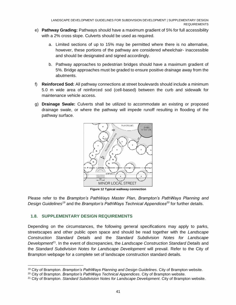
LANDSCAPE DEVELOPMENT GUIDELINES FOR SUBDIVISION DEVELOPMENT | SUPPLEMENTARY DESIGN
REQUIREMENTS
41
e) Pathway Grading: Pathways should have a maximum gradient of 5% for full accessibility
with a 2% cross slope. Culverts should be used as required.
a. Limited sections of up to 15% may be permitted where there is no alternative,
however, these portions of the pathway are considered wheelchair- inaccessible
and should be designated and signed accordingly.
b. Pathway approaches to pedestrian bridges should have a maximum gradient of
5%. Bridge approaches must be graded to ensure positive drainage away from the
abutments.
f) Reinforced Sod: All pathway connections at street boulevards should include a minimum
5.0 m wide area of reinforced sod (cell-based) between the curb and sidewalk for
maintenance vehicle access.
g) Drainage Swale: Culverts shall be utilized to accommodate an existing or proposed
drainage swale, or where the pathway will impede runoff resulting in flooding of the
pathway surface.
Figure 12 Typical walkway connection
Please refer to the Brampton’s PathWays Master Plan, Brampton’s PathWays Planning and
Design Guidelines19 and the Brampton’s PathWays Technical Appendices20 for further details.
1.8. SUPPLEMENTARY DESIGN REQUIREMENTS
Depending on the circumstances, the following general specifications may apply to parks,
streetscapes and other public open space and should be read together with the Landscape
Construction Standard Details and the Standard Subdivision Notes for Landscape
Development21. In the event of discrepancies, the Landscape Construction Standard Details and
the Standard Subdivision Notes for Landscape Development will prevail. Refer to the City of
Brampton webpage for a complete set of landscape construction standard details.
19 City of Brampton. Brampton’s PathWays Planning and Design Guidelines. City of Brampton website. 20 City of Brampton. Brampton’s PathWays Technical Appendices. City of Brampton website. 21 City of Brampton. Standard Subdivision Notes for Landscape Development. City of Brampton website.
LANDSCAPE DEVELOPMENT GUIDELINES FOR SUBDIVISION DEVELOPMENT | SUPPLEMENTARY DESIGN
REQUIREMENTS
42
1.8.1. Site Grading
a) Culverts are generally discouraged, but where they are needed to avoid potential ponding,
their minimum diameter should be 300 mm and minimum length should be 7.0 m. They
should include galvanized end aprons.
b) Sheet drainage may be permitted onto boulevards where there is no sidewalk.
c) Conventional swales should have a minimum slope of 2% and should not exceed 80.0 m
in length. The centre line of swales must be a minimum of 3.0 m from fence lines, property
lines, pathways or sidewalks, planting beds and trees unless otherwise specified. The side
slope gradient should not exceed 4:1.
d) Bio-swales that include an adequate infiltration component to accommodate moderate
rain events, may be designed at less than 2.0%.
1.8.2. Sodding and Seeding
Sodding and seeding is to be supplied and installed in accordance with the Standard Subdivision
Notes for Landscape Development (Park Construction Standard Detail No. L010). The low-
maintenance (‘low grow’) turf may be specified in select locations which will be determined during
the drawing review process.
1.8.3. Planting
Refer to the comprehensive Appendix B: Plant Chart for selections considered suitable for various
applications in Brampton. Minimum plant material sizes shall be:
Deciduous Trees 70 mm caliper minimum
Coniferous Trees 1.8 m to 3.0 m height
Shrubs 60 cm to 100 cm height
Groundcovers/ Perennials 1 gal. potted/container grown
Ornamental grasses and vines are generally discouraged in parks, buffers, medians and entry
feature beds and may only be used selectively with the City’s approval in limited quantities as a
visual accent.
1.8.4. Retaining Walls
a) Material: Retaining walls should be of cast in place concrete, precast concrete or natural
stone construction.
b) Design and Construction:
a. Walls of 600 mm or higher must be designed by a certified structural engineer.
LANDSCAPE DEVELOPMENT GUIDELINES FOR SUBDIVISION DEVELOPMENT | SUPPLEMENTARY DESIGN
REQUIREMENTS
43
b. The Public Works and Engineering Department must review the plans and the
structural engineer shall provide to the City written certification that the wall was
constructed in accordance with the approved plans.
c. Walls 600 mm or higher must have an appropriate safety barrier.
c) Fences: Walls in combination with chain link fences shall be of precast or cast-in-place
concrete with the fence posts core drilled into the wall.
d) Armourstone Retaining Walls: Generally, armourstone retaining walls are not
acceptable in Neighbourhood Parks and scenic outlooks, and can only be used selectively
with the City’s approval.
a. If used, the armourstone must be a dimensional architectural grade of Wiarton
stone with flat tops and square ends that can be neatly jointed.
1.8.5. Fencing
Please refer to Subdivision and Site Plan Fencing for fencing and noise attenuation requirements.
All fencing shall be supplied and installed in accordance with the Parks Construction Standard
Details.
1.8.6. Signage
The framework for outdoor wayfinding and signage is detailed in the Outdoor Wayfinding and
Signage Program22. Please refer to this document for further information.
22 City of Brampton. Outdoor Wayfinding and Signage Program. City of Brampton website.
LANDSCAPE SUBMISSIONS FOR SUBDIVISION DEVELOPMENT | General Requirements
44
LANDSCAPE SUBMISSIONS FOR SUBDIVISION DEVELOPMENT
1.9. General Requirements
1.9.1. Applicant’s Responsibilities
For the duration of the design development, construction, and warranty period, the applicant’s
responsibilities are to:
Secure and compensate qualified design consultants
Obtain all necessary approvals and permits
Prepare the project site for construction
1.9.2. Consultant’s Responsibilities
The consulting landscape architect shall represent the applicant and ensure that all submissions
are coordinated with the engineering submissions and the final approved engineering drawing.
The consulting landscape architect shall be a full member of the Ontario Association of Landscape
Architects (OALA) with stamp. The consultant’s responsibilities are to:
Prepare concept plans, master plans, and construction drawings
Administer the tendering process, construction review, contract administration and post
construction administration
Liaise with external agencies which may have concerns related to the project and obtain
all required approvals (i.e.: Conservation Authorities, School Boards, Region of Peel, etc.)
Liaise with other departments within the City of Brampton to obtain all required approvals
Co-ordinate meetings and site inspections
Prepare and circulate all meeting minutes
1.10. Submissions Prior to Draft Plan Approval
1.10.1. Concept Plan
Concept Plans for all open space blocks within the plan of subdivision showing recreational trail
connections shall be submitted to the satisfaction of the Public Works and Engineering
Department and shall comply with the approved Community Design Guidelines.
A Tree Evaluation Report shall be submitted as part of the Concept Plan submission.
Please refer to the Tableland Tree Assessment Guidelines for further information.
Special Studies related to stormwater management, groundwater and surface water
hydrology, vegetation, soils, etc. shall be prepared by the consultant and submitted to the
Public Works and Engineering Department as required.
A Woodland Management Plan, where required, shall be prepared by the consulting
arborist and submitted to the Environmental Planning in accordance with the City’s
LANDSCAPE SUBMISSIONS FOR SUBDIVISION DEVELOPMENT | Submissions Prior to Registration of Subdivision
45
Woodland Management Plan guidelines. The Woodland Management Plan shall be
included with the 1st landscape submission described below.
1.11. Submissions Prior to Registration of Subdivision
Engineering and landscape design submissions for subdivisions are based on a three submission
review and an optional pre-servicing submission. Any submission that is deemed incomplete will
not be processed and will be returned to the applicant.
A pre-consultation meeting is to be arranged by the engineering consultant with
engineering staff to discuss the submission prior to the first engineering and landscape
submission.
A covering letter is to be included with each landscape submission that will certify the
completeness of the submission and list any exceptions with the package and/or design
that are not in accordance with City Standards and requirements.
If additional submissions are necessary due to poor quality of work or not having
incorporating requested changes, then the City will ask for an interim submission which
will be subject to an additional charge.
Refer to the Submission Requirements for New Subdivisions 23checklist for further information.
1.11.1. Plan Format
The applicant or consulting landscape architect is encouraged to request from the City the
“official” polygon(s) representing the subject lands of the application. Please refer to the Digital
Submission Standards – Landscape Plans24 for further information.
All plans shall be standard A1 (594 mm x 841 mm) metric size and 1:500 scale minimum.
Enlargements, sections, elevations and details shall be included as required.
The following items shall be included in the title block of each drawing:
o Name and address of the applicant,
o Name and address of the consultant,
o Project name,
o Region of Peel 21T file number,
o City file number,
o General notes,
o Revision block,
o Key plan,
o Legend,
o North arrow,
o Drawing scale; and
o Consultant’s stamp.
23 City of Brampton. Submission Requirements for New Subdivisions. City of Brampton website. 24 City of Brampton. Digital Submission Standards – Landscape Plans. City of Brampton website.
LANDSCAPE SUBMISSIONS FOR SUBDIVISION DEVELOPMENT | Submissions Prior to Registration of Subdivision
46
All plans that are submitted for review and approval are to incorporate the Parks Construction
Standard Details, Standard Subdivision Notes for Landscape Development and Landscape
Specifications as applicable. The consultant is still required to produce project-specific, non-
standard details where necessary. As the Parks Construction Standard Details, Standard
Subdivision Notes for Landscape Development and Landscape Specifications are updated
periodically, it is the responsibility of the consultant to make sure the most current information is
used.
1.11.2. Tree Preservation Plan Prior to Pre-Servicing
A Tree Preservation Plan shall be submitted to the City for review and approval. Please refer to
the Tableland Tree Assessment Guidelines for further information.
Prior to the issuance of a topsoil stripping permit, protective hoarding shall be installed in
accordance with the approved Tree Inventory and Preservation Plan:
o along the property boundary where the plan abuts the existing park block and/or
along the dripline of any vegetation with the park block
o along the buffer block line of any woodland or greenbelt buffer block
o along or beyond the dripline of any vegetation noted for preservation
All hoarding will be provided and erected by the applicant at their expense and to the
satisfaction of the City, prior to the topsoil stripping, pre-servicing or any construction
occurring on the site, and shall be maintained by the applicant throughout all phases of
the servicing and construction of the site.
A letter from the consulting landscape architect or arborist shall be submitted to the City
stating that all tree preservation hoarding is installed in accordance with the approved Tree
Inventory and Preservation Plan
1.11.3. Woodland Development Plan
Please refer to the City of Brampton’s Woodland Management Plan Guidelines.
1.11.4. 1st Landscape Submission
Subdivision landscape plans comprising parks, open space and streetscape plans will be
received by the Environment and Development Engineering Division in conjunction with
the subdivision engineering plans submission.
A covering letter from the consulting landscape architect will accompany each landscape
submission stating that the landscape plans are coordinated with the engineering plans
and in compliance with the approved Community Design Guidelines and City standards.
The letter will also identify any exceptions with the package and/or design that are not in
accordance with City standards and requirements.
Should the plans not be acceptable, the consultant and the applicant will be notified in
writing and the submission package returned to the consultant for amendment as required.
LANDSCAPE SUBMISSIONS FOR SUBDIVISION DEVELOPMENT | Submissions Prior to Registration of Subdivision
47
Plans are to be submitted for review, based on the approved Draft Plan requirements and
shall comply with both the Concept Plans and the approved Community Design
Guidelines.
The Schedule of Quantities (Appendix D: Schedule of Quantities) shall be located on
the cover page of the landscape submission.
Landscape plans for all open space blocks shall include, but is not limited to, the following:
Planting plans,
Layout plans,
Lighting plans,
Grading and servicing plans (existing and proposed spot elevations, contours to within
10.0 m at the property lines, top and bottom elevations for retaining walls/curbs, etc.),
Tree preservation plans,
Woodland development plans,
City standard details; and
Other non-standard construction details.
All landscape plans shall be in accordance with the Parks Construction Standard Details and
Landscape Specifications.
Cost estimates shall be submitted on the City of Brampton Cost Estimation Forms (Appendix E:
Parkland Development Bid Comparison Form) with the signature and stamp of the consulting
landscape architect.
If playgrounds are planned for the park block, the following guidelines apply:
A minimum of three (3) playground designs by play equipment suppliers, which are
approved by the City, shall be included in the submission accompanied by cost estimates
that indicate the supply and install price of each component (e.g. swings, spring toys, etc.).
City staff will define the playground budget prior to receiving playground designs.
A covering letter from the playground equipment manufacturer shall confirm that the
playground design meets or exceeds the Annex H addition to CAN/CSA-Z614 and
describe all proposed ground-level and elevated accessible components.
Submission of Plans:
Submit one set of plans to the Region of Peel Police for CPTED comments.
Submit to other agencies (i.e.: CVC, TRCA, MNRF, MTO, MOECC, TCPL, etc.) as
required for review and comment.
If redlined copies are returned to the consultant with the City’s comments, they must be
returned with the following submission.
LANDSCAPE SUBMISSIONS FOR SUBDIVISION DEVELOPMENT | Submissions Prior to Registration of Subdivision
48
1.11.5. 2nd Landscape Submission
The 2nd submission shall consist of:
Covering letter,
Revised drawings,
Revised cost estimation forms,
Redlined 1st submission drawings; and
A written response addressing all 1st submission comments.
1.11.6. Final Landscape Submission and Plan Approval (Hard Copies)
The final submission shall consist of:
Covering letter,
Revised drawings,
Revised cost estimation forms,
Redlined 2nd submission drawings; and
Written response addressing all 2nd submission comments.
If no further revisions are required, the City will request in writing the ‘Approved Landscape
Drawings’ submission described below.
Copies of approvals from all relevant agencies (i.e. TRCA, CVC, MNRF, MTO, MOECC,
TCPL, Brampton Hydro, Peel Regional Police, etc.) shall be included with the final
submission.
A letter of credit to secure the full value of the proposed landscape works will be required.
The consultant shall submit the ‘Approved Landscape Drawings’ submission to the City, which
consists of the following hard copies:
Three (3) full size, bound and collated sets of all approved drawings with the note
‘Approved Landscape Drawings’ and the date submitted in the revision box of each
drawing, with two (2) sets rolled and one (1) set folded
Two (2) 11” x 17” reduced size, bound and collated sets of all approved drawings
Two (2) copies of all approved cost estimation forms
Three (3) full size coloured copies of the Detailed Homebuyers Information Map along with
the number of copies that the applicant will require
Two (2) 8 ½” x 14” reproducible reductions of the Final Homebuyers Information Map
All landscape drawings shall be approved prior to registration.
LANDSCAPE CONSTRUCTION FOR SUBDIVISION DEVELOPMENT | Tender Documents, Review, and Award of Contract (For
Works Eligible for Levy Credit only – City Costs)
49
1.11.7. Digital Plan Requirements for Final Submission
The consultant shall submit a digital copy of the ‘Approved Landscape Drawings’ submission to
the City, which consists of the following:
Two (2) CDs or USBs with PDF files of all approved drawings, cost estimation forms and
unsigned detailed HBIM. Ensure that the CD cover or USB is labeled with the date,
subdivision name, City file number, 21T number and a note stating ‘Approved Landscape
Drawings & Cost Estimation Forms’
Two (2) CDs or USBs with CAD files of the plan in MicroStation DGN (2D) or AutoCAD
DWG (2D) format following the level structure provided in the Digital Submission
Standards – Landscape Drawings
LANDSCAPE CONSTRUCTION FOR SUBDIVISION DEVELOPMENT
1.12. Tender Documents, Review, and Award of Contract (For Works Eligible for Levy
Credit only – City Costs)
The consulting landscape architect shall prepare tender documents, including
construction drawings, details, specifications and tender forms as required.
The tender package shall be reviewed and approved by the City before the tender call to
ensure that it meets the current landscape development standards.
Documents shall conform to the City standard details, specifications, and tender forms,
the Canadian National Master Construction Specification (NMS), the Canadian
Construction Documentation Committee (CCDC) and the Ontario Provincial Standards
(OPS) where applicable.
The consulting landscape architect shall submit a schedule outlining dates for the review
of the tender package, tender release, and closing dates. Furthermore, the developer and
the consulting landscape architect shall meet with the City to establish an acceptable
bidder's list.
Prior to award of the contract, the consulting landscape architect shall submit to the City,
a recommendation of which bid is to be accepted for review and approval.
The consulting landscape architect shall provide a spreadsheet of the unit prices for all
bids for City record purposes.
1.13. Pre-Construction Meeting (All Works)
The consulting landscape architect shall submit a construction schedule and a copy of the
source topsoil analysis and recommendations for amendments for City review prior to
scheduling a pre-construction meeting.
For all works that are eligible for levy credit (City costs), the consulting landscape architect
shall also submit a digital copy of the Parkland Development Bid Comparison Form
(Appendix E: Parkland Development Bid Comparison Form) for development charges
tracking.
COMPLETION OF LANDSCAPE WORK FOR SUBDIVISON DEVELOPMENT | Weekly Progress Inspections (for Works Eligible for
Levy Credit only – City Costs)
50
Following the submittal of the documents noted above, the consulting landscape architect
shall arrange with the City and contractor a pre-construction meeting for all landscape
works.
The consulting landscape architect shall update the Status Report for Preliminary and
Final Acceptance (Appendix F: Status Report for Preliminary and Final Acceptance) for
the duration of the construction and maintenance period. This report will be required prior
to the Preliminary and Final Acceptance inspections.
The City may at its discretion complete Vendor Performance Records as a method of
recording vendor performance, which could vary from superior to unsatisfactory
depending on the circumstances. A record of unsatisfactory performance may result in
the City not pre-qualifying this company to bid on future projects.
1.14. Weekly Progress Inspections (for Works Eligible for Levy Credit only – City Costs)
The consulting landscape architect shall:
o Provide inspection services, coordinate weekly site meetings and act as a liaison
between the developer and the City.
o Record and circulate the minutes of all meetings, process all change orders, site
directives, substitutions, invoices and payment certificates.
Construction review includes, but is not limited to, the following:
o Rough and fine grading (including certification),
o Topsoil analysis,
o Compaction tests,
o Layout and approval of facilities,
o Playground subdrains,
o Certification of structures,
o Materials testing,
o Lighting,
o Plant material; and
o Sodding/seeding.
It is the responsibility of the consulting landscape architect to inspect the site works throughout
the construction phase and to certify in writing that all site works conform to the approved
landscape plans and details. Site works that do not meet the City’s requirements will be rejected
by the City.
COMPLETION OF LANDSCAPE WORK FOR SUBDIVISON DEVELOPMENT
1.15. Preliminary Acceptance
Prior to arranging a meeting for Preliminary Acceptance by the City, the consulting
landscape architect shall review all of the works on site and provide a Certification of
Landscape Works for Subdivision Development (Appendix G: Certification of Landscape
Works for Subdivision Development) stating that all of the works have been installed in
accordance with the approved landscape plans.
COMPLETION OF LANDSCAPE WORK FOR SUBDIVISON DEVELOPMENT | Preliminary Acceptance
51
Prior to Preliminary Acceptance, a third-party, independent playground inspection by a
current CPRA (Canadian Parks and Recreation Association) Canadian Certified
Playground Inspector is required for any play or exercise equipment.
o Please note that, notwithstanding the third-party inspection, the CSA Playground
Compliance Certificate from the manufacturer is also required.
o The Playground Inspector’s scope of work will include the initial inspection of the
entire playground (including the resilient surfacing drop test), the production of an
inspection report and the subsequent verification by the inspector that any
identified deficiencies have been corrected.
o The cost of correcting all identified deficiencies and ensuring that the playground
and all components therein meet required safety standards will be borne by the
play equipment supplier or playground contractor, as is applicable.
At the time of Preliminary Acceptance, the following documents are required:
o ESA Connection Certificate for site electrical;
o Occupancy and final permit for shade structures, and;
o Region of Peel clearance for water services.
At the time of Preliminary Acceptance of playgrounds, the consulting landscape architect
shall provide a playground maintenance/touch up kit, a parts list and operating manuals.
Following the submittal of the Certification of Landscape Works for Subdivision
Development (Appendix G: Certification of Landscape Works for Subdivision
Development), the consulting landscape architect shall arrange with the City and
contractor an inspection for Preliminary Acceptance.
o At the inspection, the consulting landscape architect shall provide:
Two (2) 11”x17” reductions of the Plan of Subdivision’s Schedule of
Quantities (Appendix D: Schedule of Quantities) marked-up to identify the
scope of landscape works considered for Preliminary Acceptance,
Completed Status Report for Preliminary and Final Acceptance (Appendix
F: Status Report for Preliminary and Final Acceptance) and all supporting
documents (refer to item nos. 1-17 of Status Report), and
Copies of all inspection reports and meeting minutes.
o All required documentation must be compiled in a bound folder and presented to
City staff at the beginning of the Preliminary Acceptance meeting.
The two (2) year warranty period shall start on the date that Preliminary Acceptance has
been granted and shall not be backdated.
o The developer or consultant shall provide the City with written confirmation that the
maintenance obligations as outlined in subsection 17.6 of the Subdivision
Agreement will be fulfilled until Final Acceptance.
o In cases of emergencies, as determined by the City in which the developer does
not fulfill its required maintenance obligations, such work may be done without prior
notice but the developer shall be notified forth-with.
o The cost of such work will be calculated by the City and will include a management
fee of forty percent (40%) as outlined in subsection 28.2 of the Subdivision
Agreement.
COMPLETION OF LANDSCAPE WORK FOR SUBDIVISON DEVELOPMENT | Payment Certificates (for Works Eligible for Levy
Credit only – City Costs)
52
Inspections for Preliminary Acceptance of plant material and sod shall not be performed
after November 15th or the first snowfall, whichever comes first.
o In such circumstances, the acceptance inspections will be delayed until the
following growing season and the two-year warranty will take effect at that time.
The City will schedule a Preliminary Acceptance meeting and assume the responsibility
for the maintenance of sod after it has been well rooted, established and cut a minimum
of 2 times.
Plant Material that in the opinion of the City is not in a healthy growing condition shall be
replaced at the developer’s expense and subject to a new one-year warranty.
o The replacements shall be completed immediately to avoid additional warranty
extensions.
Other works that exhibit settlement, deterioration or other deficiencies shall be corrected
at the developer’s expense.
At the time of the inspection, the City will issue a Preliminary Acceptance Report to the
consulting landscape architect noting deficiencies identified at the inspection and
expected one-year interim and Final Acceptance inspection dates.
The consulting landscape architect shall circulate minutes of the meetings and deficiency
lists within 7 days so as to not delay the Contractor’s replacement schedule.
The contractor shall complete the remedial work within 21 days from the date that the
minutes of the meetings and/or deficiency lists were issued.
Once the remedial work has been performed, the consulting landscape architect shall
submit written confirmation to the City stating that all noted deficiencies have been
corrected to its satisfaction.
If the remedial work has not been performed within 21 days, the date of Preliminary
Acceptance will be delayed until the consulting landscape architect has issued written
confirmation stating that all noted deficiencies have been corrected to its satisfaction.
1.16. Payment Certificates (for Works Eligible for Levy Credit only – City Costs)
Prior to payment by the City to the developer for works completed, the following information is
required:
Letter from the consulting landscape architect identifying the final reimbursement costs for
the parkland construction including all contract changes and quantity adjustments.
Invoice from the developer identifying the final reimbursement costs.
Statutory Declaration from the developer stating that all accounts for labour,
subcontractors, supplies, etc. have been paid in full.
WSIB Clearance Certificate from the contractor.
Certificate of Publication certifying official notice published in the Daily Commercial News.
A copy of the applicable approved cost estimates.
A copy of all contract changes, change orders, and quantity adjustments.
1.17. One Year Interim Inspection
COMPLETION OF LANDSCAPE WORK FOR SUBDIVISON DEVELOPMENT | Final Acceptance
53
The consulting landscape architect shall review the site to satisfy that any deficiencies
have been corrected to its satisfaction.
The consulting landscape architect shall arrange an interim inspection of all works one
year from the date of Preliminary Acceptance with the City and the contractor.
Interim inspections shall be performed prior to October 15th. If the interim inspection has
not been performed prior to October 15th, the warranty on all works shall be extended by
the same time as the delay in arranging the one-year interim inspection. Final Acceptance
Certificates shall not be issued until one year after the interim inspection.
Plant Material that in the opinion of the City is not in a healthy growing condition shall be
replaced at the developer’s expense and shall be subject to a new one-year warranty.
The replacements shall be completed immediately to avoid additional warranty
extensions.
Other works that exhibit settlement, deterioration or other deficiencies shall be corrected
at the developer’s expense.
The consulting landscape architect shall circulate minutes of the meetings and deficiency
lists within 7 days so as to not delay the Contractor’s replacement schedule.
The contractor shall complete remedial work within 21 days from the date that the minutes
of the meetings and/or deficiency lists were issued.
Once the remedial work has been performed, the consulting landscape architect shall
submit written confirmation to the City stating that all noted deficiencies have been
corrected to its satisfaction.
If the remedial work has not been performed within 21 days, the date of the interim
inspection will be delayed until the consulting landscape architect has issued written
confirmation stating that all noted deficiencies have been corrected to its satisfaction.
1.18. Final Acceptance
Prior to arranging a meeting for Final Acceptance by the City, the consulting landscape
architect shall review the site to ensure that all deficiencies have been corrected to its
satisfaction and shall submit a completed Status Report for Preliminary and Final
Acceptance (Appendix F: Status Report for Preliminary and Final Acceptance).
Following the submittal of the completed Status Report for Preliminary and Final
Acceptance (Appendix F: Status Report for Preliminary and Final Acceptance), the
consulting landscape architect shall request an inspection for Final Acceptance of all
works not less than one year from the date of the interim inspection and arrange for the
City and the contractor to attend.
o At the inspection, the consulting landscape architect shall provide any outstanding
documents as well as copies of any conservation authority sign-offs.
Inspections for Final Acceptance shall be performed prior to October 15th.
o If the inspection for Final Acceptance has not been performed prior to October
15th, the developer shall be required to extend the warranty of the plant material
until the following growing season.
Plant Material that in the opinion of the City is not in a healthy growing condition shall be
replaced at the developer’s expense and shall be subject to a new one-year warranty.
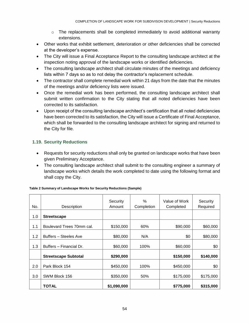
COMPLETION OF LANDSCAPE WORK FOR SUBDIVISON DEVELOPMENT | Security Reductions
54
o The replacements shall be completed immediately to avoid additional warranty
extensions.
Other works that exhibit settlement, deterioration or other deficiencies shall be corrected
at the developer’s expense.
The City will issue a Final Acceptance Report to the consulting landscape architect at the
inspection noting approval of the landscape works or identified deficiencies.
The consulting landscape architect shall circulate minutes of the meetings and deficiency
lists within 7 days so as to not delay the contractor’s replacement schedule.
The contractor shall complete remedial work within 21 days from the date that the minutes
of the meetings and/or deficiency lists were issued.
Once the remedial work has been performed, the consulting landscape architect shall
submit written confirmation to the City stating that all noted deficiencies have been
corrected to its satisfaction.
Upon receipt of the consulting landscape architect’s certification that all noted deficiencies
have been corrected to its satisfaction, the City will issue a Certificate of Final Acceptance,
which shall be forwarded to the consulting landscape architect for signing and returned to
the City for file.
1.19. Security Reductions
Requests for security reductions shall only be granted on landscape works that have been
given Preliminary Acceptance.
The consulting landscape architect shall submit to the consulting engineer a summary of
landscape works which details the work completed to date using the following format and
shall copy the City.
Table 2 Summary of Landscape Works for Security Reductions (Sample)
No. Description
Security
Amount
%
Completion
Value of Work
Completed
Security
Required
1.0 Streetscape
1.1 Boulevard Trees 70mm cal. $150,000 60% $90,000 $60,000
1.2 Buffers – Steeles Ave $80,000 N/A $0 $80,000
1.3 Buffers – Financial Dr. $60,000 100% $60,000 $0
Streetscape Subtotal $290,000 $150,000 $140,000
2.0 Park Block 154 $450,000 100% $450,000 $0
3.0 SWM Block 156 $350,000 50% $175,000 $175,000
TOTAL $1,090,000 $775,000 $315,000
COMPLETION OF LANDSCAPE WORK FOR SUBDIVISON DEVELOPMENT | Subdivision Release and Assumption
55
The consulting landscape architect, on behalf of the developer, may apply to Environment
and Development Engineering Division for full release of securities following the issuance
of the Final Acceptance Certificates. Such requests are normally submitted through the
consulting engineer.
1.20. Subdivision Release and Assumption
The consulting landscape architect shall submit all project close-out documents and as-
built drawings in both hard copy and digital formats prior to the release and assumption of
a subdivision.
o As-built-drawing submission requirements:
One (1) folded set hard copy
One (1) 11” x 17” reduction hard copy
Two (2) CDs or USBs with AutoCAD or MicroStation, and PDF.
o For further information related to the digital drawing submission, refer to the
Development Digital Submissions Requirements Manual.
The applicant shall apply to the Environment and Development Engineering Division for
Subdivision Release and Assumption, once Final Acceptance of all works has been
granted.
LANDSCAPE DEVELOPMENT GUIDELINES FOR SITE PLAN DEVELOPMENT | General Considerations
56
PART 2: SITE PLAN DEVELOPMENT
LANDSCAPE DEVELOPMENT GUIDELINES FOR SITE PLAN DEVELOPMENT
1.1. General Considerations
This section is intended to provide an overview of the principal design objectives and
requirements for landscaping and outdoor recreation facilities related to site plan developments.
For a detailed manual outlining the site plan process and submission requirements refer to the
City of Brampton Site Plan Review Process document.
The Environment and Development Engineering Division in the Public Works Department has
jurisdiction over the landscape treatment of industrial, commercial, institutional and multiple
residential projects in connection with the site plan approval process.
All inquiries and submissions should be directed to:
Public Works and Engineering Department
Environment and Development Engineering Division
2 Wellington Street West
Brampton, Ontario, L6Y 4R2
Attention: Manager, Open Space Development
Telephone: (905) 874-3448
1.2. Industrial
1.2.1. Design Objectives
Industrial sites, which are aesthetically inoffensive and acceptable to viewers from the adjacent
properties and streets and which adequately, accommodate the needs of employees, visitors,
and the industrial functions of loading and storage.
1.2.2. Design Requirements
a) Provision of Visual Screening: Visually screen typically unattractive elements
including parking lots, storage and loading areas and architectural features such as large
expanses of blank exterior walls from adjacent streets and higher quality industrial or
non-industrial uses.
b) Landscape Treatment: Recognition of the special needs for landscape treatment where
industrial sites abut major collector or arterial roads and non-industrial uses.
LANDSCAPE DEVELOPMENT GUIDELINES FOR SITE PLAN DEVELOPMENT | Commercial
57
c) Recreational Open Space: Provision of recreational open space such as courtyards
and games areas for employees in labour intensive industries should be encouraged.
1.3. Commercial
1.3.1. Design Objectives
Provide utilitarian commercial facilities which are aesthetically and functionally compatible with
the surrounding neighbourhood and community and which enhance and bring credit to the
community through their design and landscape features.
1.3.2. Design Requirements
a) Provision of Visual Screening:
a. Screen commercial sites from adjacent residential areas with the use of
permanent masonry walls and landscaping as required by the City.
b. Reconcile between the desired visibility of storefronts and displays and the need
to screen parking areas from the street.
b) Pedestrian Areas: Establish functional, adequate pedestrian areas that provide direct
access from parking to building entrances.
c) Light Glare: Prevent light glare on adjacent streets and properties.
1.4. High-Density Residential
1.4.1. Design Objectives
Provide utilitarian outdoor environments that respond to the special recreational needs of
apartment occupants.
Provide convenient easily identifiable access points and routes between buildings and other
internal and Neighbourhood facilities.
Utilize site development to minimize the impact of high-rise architecture on site users and the
surrounding Neighbourhood.
1.4.2. Design Requirements
a) Vertical Scale: Minimize the vertical scale of buildings from within the site and from
adjacent properties and streets through change in grade, berms, and the use of plant
material.
b) Provision of Visual Screening:
LANDSCAPE DEVELOPMENT GUIDELINES FOR SITE PLAN DEVELOPMENT | Medium-Density Residential
58
a. Screen the site from adjacent lower density residential and recreational uses.
b. Screen large parking areas and outdoor storage facilities from other functions
within the site.
c. Screen outdoor storage areas from all potential ground level views within and off
the site.
c) Pedestrian Facilities:
a. Utilize landscaping to create attractive pedestrian entrances that can be clearly
distinguished from service areas.
b. Provide sufficient pedestrian facilities and controls to protect landscaped areas
from premature wear or trampling.
c. Establish a pedestrian circulation system that provides appropriate walking
surfaces on anticipated pedestrian routes.
d. Protect other areas from pedestrian impact where necessary.
d) Recreational Open Space:
a. Utilize open space provided within the site for recreational facilities and functions.
b. Locate and design outdoor play facilities that address equally the needs of
various age groups of children and the potential impacts on other residents.
e) Landscaping Elements: Utilize landscape elements to:
a. Establish public recreation space on the site which complements the
predetermined recreation facilities.
b. Create greater energy efficiency through the provision of shade, windbreaks and
permeable surfaces.
c. Buffer and/or separate conflicting internal uses such as storage areas,
playgrounds and parking.
1.5. Medium-Density Residential
1.5.1. Design Objectives
Provide pleasant, utilitarian outdoor environments that visually buffer the buildings from
surrounding uses and adjacent streets.
Provide for some of the private recreational needs of dwelling occupants on or directly accessible
to the ground level adjacent to each unit.
LANDSCAPE DEVELOPMENT GUIDELINES FOR SITE PLAN DEVELOPMENT | Institutional (Government Offices, Schools,
Churches, Utility Buildings)
59
1.5.2. Design Requirements
a) Planting:
a. Provide “boulevard” type planting on all interior roads and parking areas.
b. Utilize plant materials to buffer obtrusive architectural features such as blank end
walls and continuous uniform facades.
b) Buffers:
a. Provide visual and/or acoustic buffers on all frontages abutting major collector or
arterial roads.
b. Such buffers may consist of berming, planting and walls as required and as
recommended by acoustical studies.
c) Privacy Fencing and Areas:
a. Provide privacy fencing where abuts low density residential, if medium density
housing is condominium.
b. Utilize structural screens, planting and earthwork to create individual privacy
areas for each dwelling unit that offers a reasonable degree of seclusion and
security.
1.6. Institutional (Government Offices, Schools, Churches, Utility Buildings)
1.6.1. Design Objectives
Provide attractive functional sites that set examples for the City’s concept of effective site
development.
Recognize the varied public visibility of institutional sites and their relative aesthetic importance
in the community.
1.6.2. Design Requirements
a) Provision of Visual Screening: Consider visual screening of typically unattractive
elements including parking lots, storage and loading areas and architectural features,
such as large expanses of blank exterior walls.
b) High Visitor Volume Facilities: Where a facility is subject to high visitor volumes (e.g.,
police, municipal offices, utilities offices, courts, libraries, the following elements should
be considered:
a. Clear identification of visitor vehicle entrances and parking
b. Attractive, clearly identified pedestrian areas and entrances that enhance the
visitors’ initial impression of the facility through appropriate landscaping
LANDSCAPE DEVELOPMENT GUIDELINES FOR SITE PLAN DEVELOPMENT | Supplementary Design Requirements
60
c) Landscape Elements:
a. Utilize landscaping as required to minimize any negative aesthetic relationships
with adjacent uses and facilities.
b. Utilize landscape elements to demonstrate to the public effective energy
conservation influences such as shade, windbreaks and permeable surfaces.
d) Recreational Open Space: Utilize open space contiguous to employee intensive
facilities for recreational facilities and functions (e.g., horseshoe pitch, badminton,
basketball, outdoor eating).
1.7. Supplementary Design Requirements
1.7.1. Street Frontage Buffering
a) Buffering: Sites abutting roads and non-industrial uses are required to provide a
minimum of 3.0 m wide landscape area planting, screen and/or decorative fencing, and
berming as required by the City.
b) Landscape Buffer Irrigation: All commercial property landscape buffers shall be
irrigated.
1.7.2. Side Yard Treatment
a) Planting: Where space permits, deciduous and/or coniferous tree planting should be
provided on the flankage to a point approximately in line with the front of the building.
b) Additional Screening: If the site abuts a non-industrial uses, additional screening
including hedging and masonry or other substantial walls may be required at the
discretion of the Commissioner of the Public Works and Engineering department.
1.7.3. Parkland and Public Open Space Buffering
a) Landscape Area: A minimum 3.0 m wide landscape area with planting shall be provided
on any site abutting a park or public open space.
b) Fence: A 1.2 m black vinyl chain link fence shall also be provided.
1.7.4. Plant Material
a) Minimum Size for Plant Material:
a. 70 mm caliper for deciduous trees
b. 1800 mm height for coniferous trees
c. 600 mm height for deciduous shrubs
LANDSCAPE DEVELOPMENT GUIDELINES FOR SITE PLAN DEVELOPMENT | Supplementary Design Requirements
61
b) Floral Displays: All street frontage landscaping on commercial and institutional sites
shall include substantial floral displays in addition to trees and shrubs.
1.7.5. Curbing
a) Cast-in-Place Concrete Curb: Landscaped areas that abut parking spaces, driveways
or parking lot aisles, shall be protected with raised cast-in-place concrete curb with curb
cuts provided at all pedestrian sidewalks.
1.7.6. Existing Vegetation
a) Preservation: The site plan guidelines of the City of Brampton require that the owner
shall make every effort to retain significant existing vegetation as identified by a
professional Arborist’s report, through the careful arrangement of buildings and other site
facilities.
a. Trees that are specified for preservation shall be protected during construction
with snow fence hoarding erected along the drip line of the trees to be preserved.
b) Compensation: Significant vegetation that cannot be reasonably preserved shall be
replaced to the satisfaction of the City and such replacements shall be indicated on the
landscape plan. Refer to the City of Brampton’s Tableland Tree Assessment Guidelines.
c) Grading: Grading shall be proposed which does not affect the existing grades near any
trees noted for preservation.
d) Tree Evaluation Report: At the City’s discretion a tree evaluation report with
recommendations carried out by a professional landscape architect or professional
arborist may be required prior to site plan approval.
The consulting landscape architect shall provide written certification that the protective
hoarding and sedimentation controls have been satisfactorily installed to the City prior to the
issuance of a fill and/or topsoil stripping permit.
1.7.7. Landscape Traffic Islands
a) Use: Landscape traffic islands shall be used to define the ends of rows of parking and
fire routes.
b) Minimum Width: Landscape traffic islands shall be a minimum width of 2.5 m.
1.7.8. Lighting
a) Parking Area and Pedestrian Lighting: Locations shall be illustrated and details for
poles and fixtures provided.
LANDSCAPE SUBMISSIONS FOR SITE PLAN DEVELOPMENT | General Responsibilities
62
1.7.9. Fencing
a) Fencing and Noise Attenuation: For fencing and noise attenuation requirements refer
to Appendix C: Subdivision and Site Plan Fencing and Wall Standards.
LANDSCAPE SUBMISSIONS FOR SITE PLAN DEVELOPMENT
1.8. General Responsibilities
The complete site plan application process and submission requirements are explained in detail
in the City of Brampton Site Plan Review Process User Guide, which can be accessed via the
following link:
http://www.brampton.ca/EN/Business/planning-development/Documents/e-
Forms/DevServ/SP-User-Guide.pdf
1.9. Submissions for Site Plan Approval
In order that applications for landscape approval can be expedited, it is essential that all
information be clearly displayed in a relatively consistent format. The following guidelines are
intended to assist in achieving this objective. A professional landscape architect, registered as a
full member of the Ontario Association of Landscape Architects, shall prepare, stamp and sign all
landscape plans and cost estimates. The Commissioner of Public Works and Engineering may
waive this requirement at his discretion.
1.9.1. Plan Format and Drawing Requirements
1.9.1.1. Size
All drawings for a specific submission should be the same size. Sheet size shall not exceed A1
and the scale shall be maximum of 1:500 metrics. Where engineering and/or architectural
drawings accompany the landscape submission all drawings should also be of similar size. All
drawings shall be collated, stapled, and folded into 8 ½” x 11”, for submission purposes.
1.9.1.2. Organization
The required information may be organized on a series of drawings or on a single drawing
depending on the complexity of the project and at the consultant’s discretion.
1.9.1.3. Drawing and Reproduction Quality
Information should be clearly delineated on a readily reproducible material. Whiteprint
reproductions should have as little background as possible. Reproductions with excessive
background that obscures the drawing will not be acceptable.
1.9.1.4. Essential Information
LANDSCAPE SUBMISSIONS FOR SITE PLAN DEVELOPMENT | Submissions for Site Plan Approval
63
Title block in lower right hand corner of drawing which indicates the title, owner, consultant,
scale and date of submission and site plan number
North arrow
Key map oriented in same direction as drawing
Legend that identifies all graphic symbols on the drawing
Drawings containing only details, elevations, sections, or perspectives should contain a
title block similar to the accompanying plan
Landscape Architect’s signed stamp
Plant material list on planting plans
1.9.1.5. Graphic Symbols
The following graphic symbols shall be used consistently throughout all drawings:
Existing contours in broken line, proposed contours in solid line
Drainage direction with solid arrows and percentage slopes
Property easement and right-of-way lines in broken line (dot-dash-style)
Underground services in individually distinct lines with labels
Existing vegetation clearly distinguished from proposed plant material
Coniferous vegetation clearly distinguished from deciduous
Sodded and seed areas clearly distinguished with the use of tones
1.9.1.6. Existing Trees
All existing trees shall be indicated on all plans according to species, size and condition. Tree
protection fencing must be provided for trees to be retained.
1.9.1.7. Proposed Trees and Shrubs
All proposed trees and shrubs shall be indicated on a drawing and on a plant list which gives
common name, generic (Latin) name, quantity, size (or caliper) and root condition of each
species.
1.9.1.8. Reports and Cost Estimates
All reports, cost estimates and other miscellaneous documents included in landscape
submissions should be in 8 ½” x 11” format with the subject matter and Site Plan Number clearly
indicated on the front.
1.9.1.9. Standard Notes
The following standards notes shall be included on all submission:
City of Brampton Standard Site Plan Landscape Notes
LANDSCAPE SUBMISSIONS FOR SITE PLAN DEVELOPMENT | Submissions for Site Plan Approval
64
1. The Contractor must notify the Public Works and Engineering Department of the City of
Brampton prior to commencement of any planting.
2. The locations of all trees on street frontages must be approved by the Public Works and
Engineering Department of the City of Brampton prior to their installation.
3. The Owner is required, upon completion of all landscape works, to submit an Acceptance
Certificate prepared by a landscape architect to the Public Works and Engineering
Department and to request an inspection by the Department.
4. All landscape works will be guaranteed for one year following inspection. Plant material,
which is not in a healthy growing condition one year after inspection, shall be replaced to
the satisfaction of the City with an additional one-year maintenance guarantee period.
Supply and plant all replacements in strict accordance with plans and specifications.
5. Sod that is damaged or missing on the public boulevard is to be repaired/installed at the
Owner’s expense.
6. Any chain link fencing and components that are installed subsequent to Site Plan approval
shall have a black gloss enamel finish by powder coat application. Prior to application of
finish, treat with Parker Bonderite and chlorothenesolvent applied in a thickness of 4-5
mils by electrostatic coat and oven cured for smooth and even surface. All chain link fabric
also to be black vinyl coated.
7. The Contractor is responsible for location of all underground services prior to excavation
of tree pits and shrub beds.
8. All T-bars to be removed at the conclusion of the warrantee period.
9. Any transformer installed subsequent to site plan approval shall be screened with plant
material to the satisfaction of the City of Brampton.
10. All signage is subject to the provisions of the sign by-law.
1.9.1.10. Specifications and Details
The submission shall include all applicable detail drawings and specifications necessary to
convey the design intent and to facilitate accurate construction. The following specifications and
details shall be included on all submissions, where applicable:
Topsoil
Grading
Seeding
Sodding
Planting
Fencing
Protection of trees
Surface treatments
Landscape structures
Any custom or specialty landscape components
LANDSCAPE CONSTRUCTION FOR SITE PLAN DEVELOPMENT | Preliminary Acceptance
65
1.9.1.11. Plan Approval and Securities
As stated in the standard site plan agreement, the Commissioner of Public Works and
Engineering may request a letter of credit to secure the full value of the proposed landscape
works. The applicant will be notified of this requirement (if applicable) at the time of site plan
submissions.
LANDSCAPE CONSTRUCTION FOR SITE PLAN DEVELOPMENT
All landscape requirements as outlined in this document and on approved drawings shall be
completed within the period stipulated in the Site Plan Agreement. Certification of completion of
the landscape and fencing works must be completed by the consulting landscape architect and
submitted to the City prior to the City releasing the letter of credit.
The owner is required to retain a qualified landscape architect to supervise all aspects of the
construction work. The City may at its discretion inspect the work from time to time and report
any deficiencies to the consultant.
COMPLETION OF LANDSCAPE WORK FOR SITE PLAN DEVELOPMENT
1.10. Preliminary Acceptance
At the completion of construction, the consulting landscape architect shall submit to the City the
Certification of Landscape Works for Site Plan Development (Appendix H: Certification of
Landscape Works for Site Plan Development).
If in the opinion of the City, the performance of the “works” is acceptable, then the City shall issue
notification of Preliminary Acceptance of the landscape works to the owner and the one-year
maintenance warranty period shall commence.
1.11. Warranty Period
A minimum of 10 percent of the security shall be held for the warranty period. The Public Works
and Engineering Department shall then recommend a suitable reduction in securities held by the
City, subject to approval by Engineering and Development Services and Legal Services.
1.12. Final Acceptance
At the expiry of the maintenance warranty period as stipulated above, and receipt of confirmation
from the owner that landscape deficiencies as identified by the City at preliminary acceptance
have been addressed, the owner may then request a final acceptance inspection and full release
of any remaining securities held by the City.
Final acceptance inspections for landscape work must occur before October 15th or they will be
scheduled for the spring of the next year.

COMPLETION OF LANDSCAPE WORK FOR SITE PLAN DEVELOPMENT | Security Reduction
66
The owner is responsible to request all inspections for final approval.
1.13. Security Reduction
In the event that any portion of the work is not completed within the time designated in the
agreement with the City, the City may exercise its right to draw on any applicable letter of credit
and apply the proceeds towards the completion of the work.
COMPLETION OF LANDSCAPE WORK FOR SITE PLAN DEVELOPMENT | Security Reduction
67
PART III: APPENDICES
Note: documents shown in this section are samples only. Full length digital versions or
templates will be provided by the City (Open Space Development) staff on request.
Appendix A. Recreational Pathways Hierarchy
Appendix B. Plant Chart
Appendix C. Subdivision and Site Plan Fencing and Wall Standards
Appendix D. Schedule of Quantities
Appendix E. Parkland Development Bid Comparison Form
Appendix F. Status Report for Preliminary and Final Acceptance
Appendix G. Certification of Landscape Works for Subdivision Development
Appendix H. Certification of Landscape Works for Site Plan Development
Appendix I. References
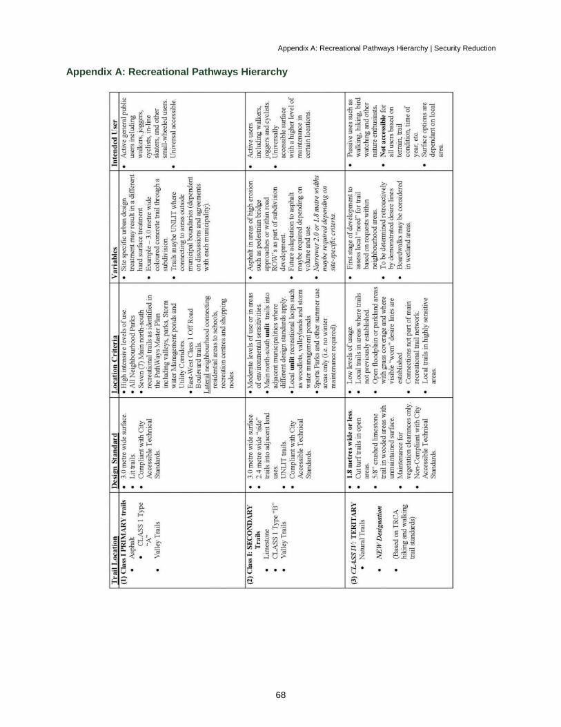
Appendix A: Recreational Pathways Hierarchy | Security Reduction
68
Appendix A: Recreational Pathways Hierarchy
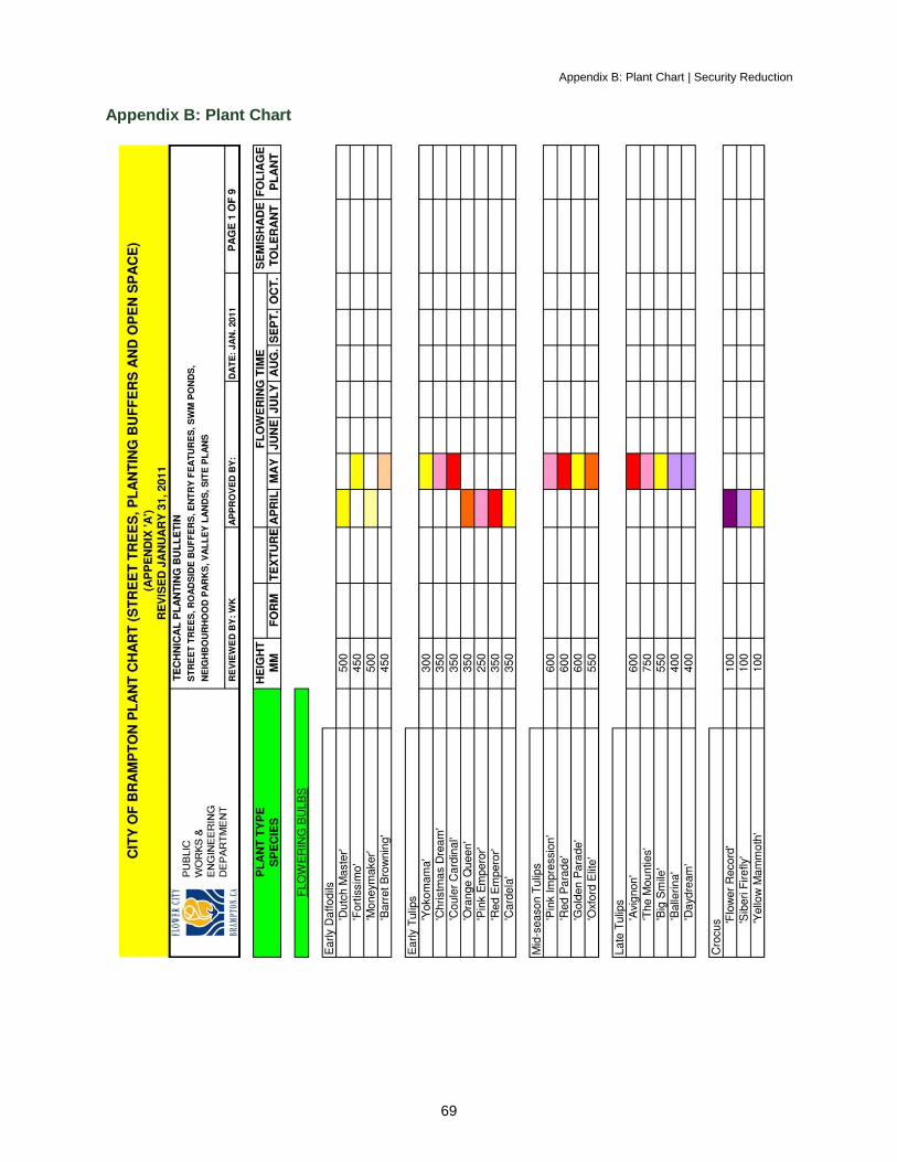
Appendix B: Plant Chart | Security Reduction
69
Appendix B: Plant Chart
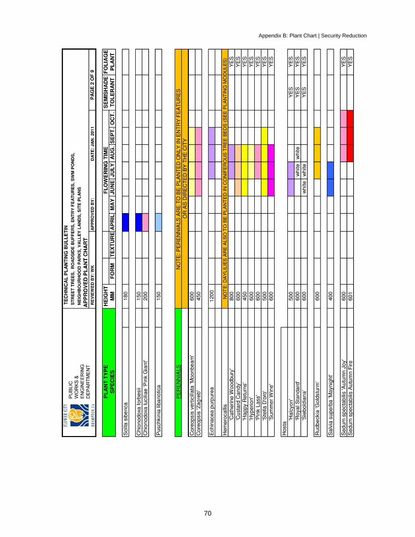
Appendix B: Plant Chart | Security Reduction
70
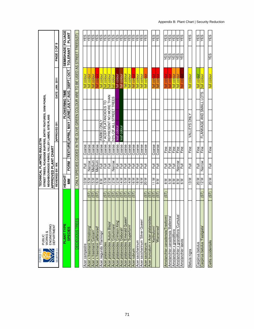
Appendix B: Plant Chart | Security Reduction
71
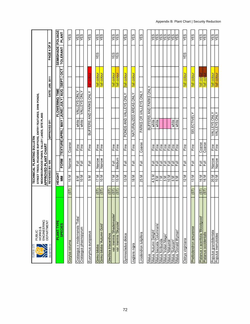
Appendix B: Plant Chart | Security Reduction
72
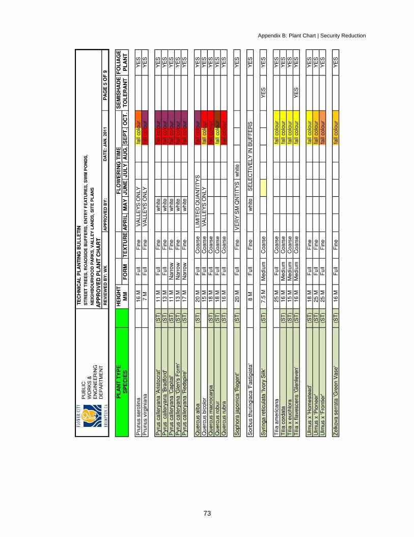
Appendix B: Plant Chart | Security Reduction
73
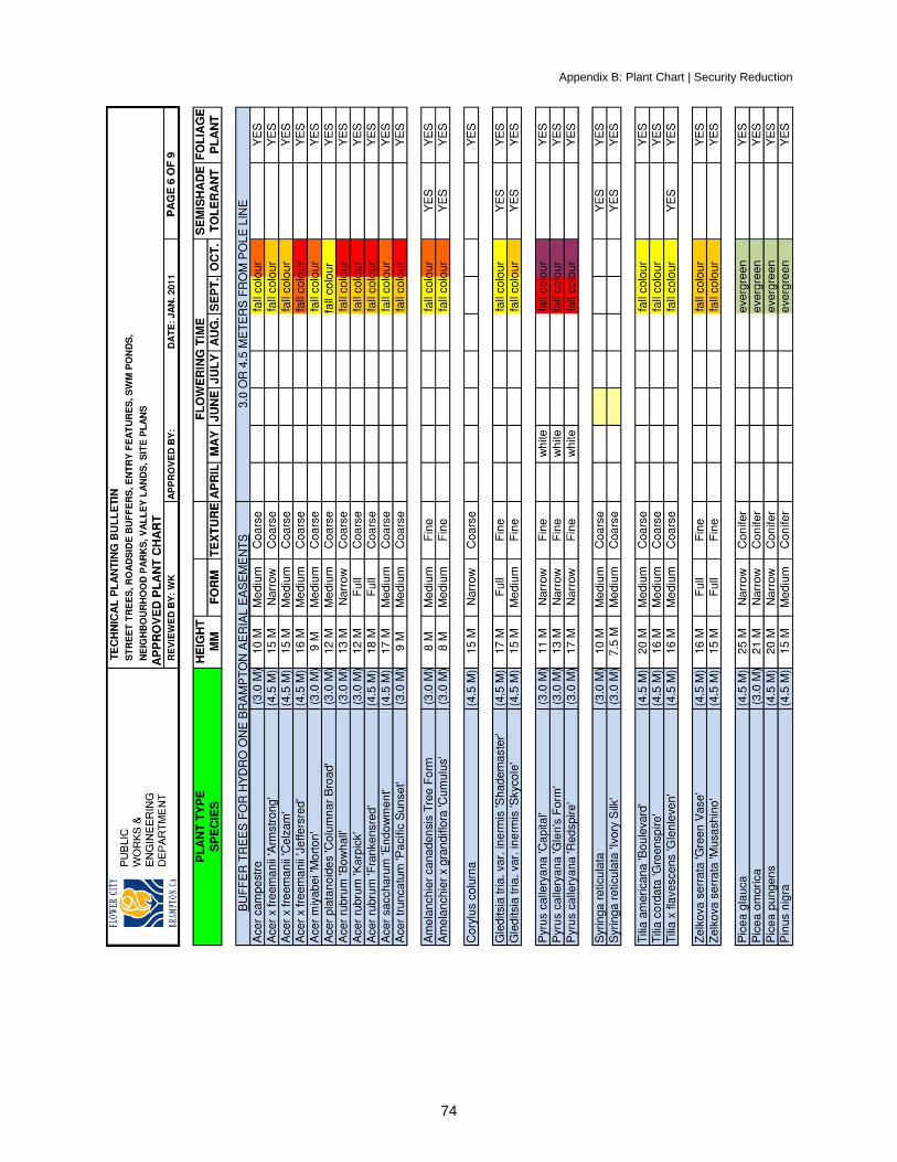
Appendix B: Plant Chart | Security Reduction
74
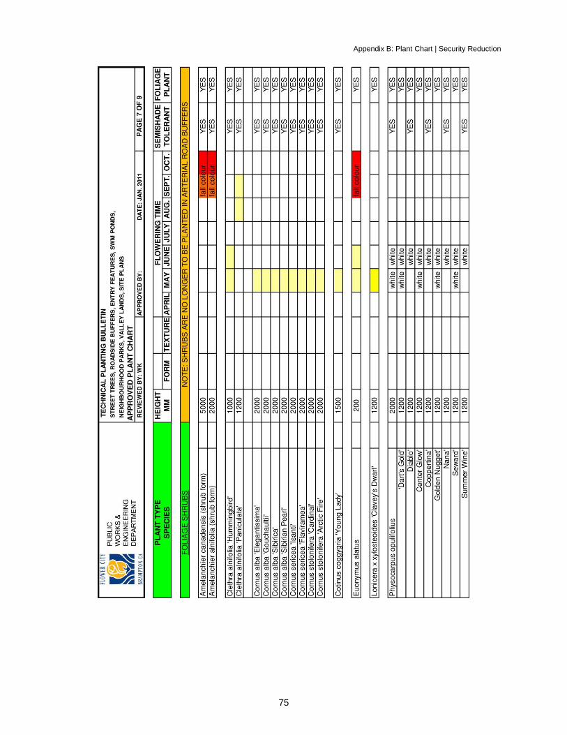
Appendix B: Plant Chart | Security Reduction
75
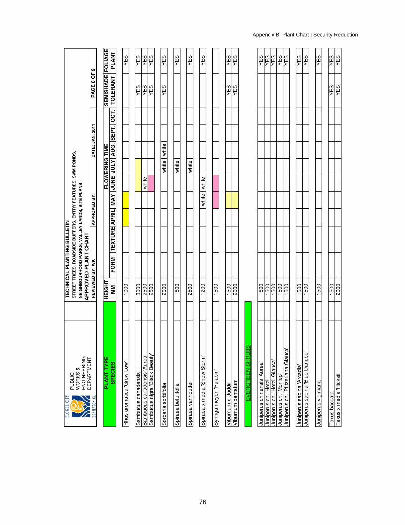
Appendix B: Plant Chart | Security Reduction
76

Appendix B: Plant Chart | Security Reduction
77
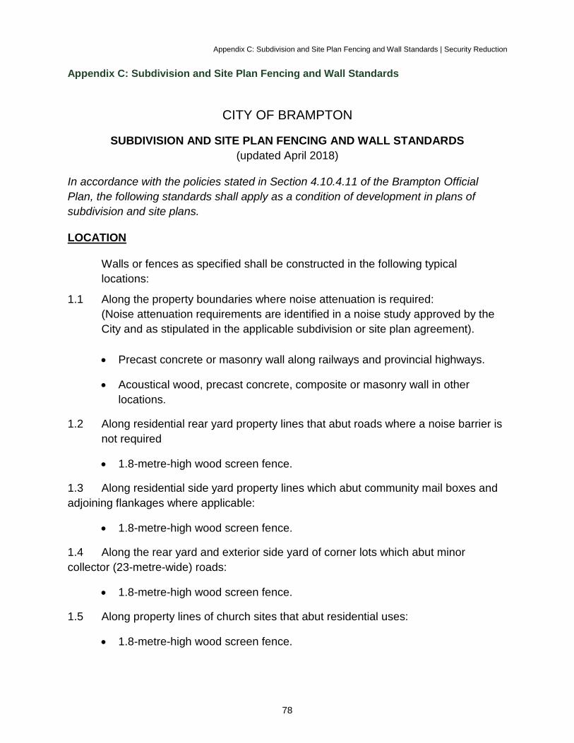
Appendix C: Subdivision and Site Plan Fencing and Wall Standards | Security Reduction
78
Appendix C: Subdivision and Site Plan Fencing and Wall Standards
CITY OF BRAMPTON
SUBDIVISION AND SITE PLAN FENCING AND WALL STANDARDS
(updated April 2018)
In accordance with the policies stated in Section 4.10.4.11 of the Brampton Official
Plan, the following standards shall apply as a condition of development in plans of
subdivision and site plans.
LOCATION
Walls or fences as specified shall be constructed in the following typical
locations:
1.1 Along the property boundaries where noise attenuation is required:
(Noise attenuation requirements are identified in a noise study approved by the
City and as stipulated in the applicable subdivision or site plan agreement).
Precast concrete or masonry wall along railways and provincial highways.
Acoustical wood, precast concrete, composite or masonry wall in other
locations.
1.2 Along residential rear yard property lines that abut roads where a noise barrier is
not required
1.8-metre-high wood screen fence.
1.3 Along residential side yard property lines which abut community mail boxes and
adjoining flankages where applicable:
1.8-metre-high wood screen fence.
1.4 Along the rear yard and exterior side yard of corner lots which abut minor
collector (23-metre-wide) roads:
1.8-metre-high wood screen fence.
1.5 Along property lines of church sites that abut residential uses:
1.8-metre-high wood screen fence.
Appendix C: Subdivision and Site Plan Fencing and Wall Standards | Security Reduction
79
1.6 Along property lines of low density residential uses (up to townhouse density)
that abut existing or proposed restaurants, gas bars with convenience retail and
other retail uses:
1.8-metre-high brick or architectural block wall.
1.7 Between other office/commercial and residential:
1.8-metre-high precast concrete fence or brick or architectural block wall.
1.8 Between small office and retail renovations (rezoned from residential) and
existing residential:
1.8-metre-high wood screen fence.
1.9 Along all rear or side yard boundaries that abut parklands and hazard lands
(except in the Rural Estate area):
1.2-metre-high chain-link fence.
1.10 Along the rear or side yard boundaries that abut valleyland in Rural Estate
developments:
1.0-metre-high conifers planted at 6 to 9 metres, .3 metre inside private
property to delineate the property boundary with one tree planted at each rear
property corner.
1.11 Along all public walkways:
1.2-metre-high chain-link fence.
1.12 Along all parallel frontages between local residential streets and arterial roads
where dwellings face the arterial road:
1.2-metre-high decorative metal fence.
1.13 Along all residential boundaries that abut school sites:
1.8-metre-high chain link fence (to be constructed by applicable school
board).
1.14 Between industrial or commercial and parkland:
Fencing or walls as determined for each location by the Commissioner of
Public Works and Engineering.
1.15 Adjacent to any portion of industrial sites where outdoor storage is permitted:
Appendix C: Subdivision and Site Plan Fencing and Wall Standards | Security Reduction
80
Pre-cast concrete walls (wood or composite noise wall designs may be
permitted adjacent to open space at the discretion of the Commissioner of
Public Works and Engineering.
1.16 In other locations to specifications required by the Commissioner of Public Works
and Engineering and as stipulated in the applicable subdivision agreement.
1.17 All walls and fences between municipal and private property shall be located
entirely on private property in accordance with the following setbacks:
i. Centre line of chain-link, decorative metal, light duty acoustic and
privacy fence to the 15cm inside private property.
ii. Centre line of acoustical wall to be 30cm inside public property along
City arterial road.
iii. Centre line of acoustic wall to be on the property line along Regional
roads.
1.18 Walls and fences in other situations not referenced in 1.17 of these standards
shall be located as follows:
i. Centred on property line between private residential uses.
ii. Entirely within the commercial, institutional or industrial property where
these uses abut residential properties.
iii. As determined by the Commissioner of Public Works and Engineering
in other situations.
2.0 OTHER REQUIREMENTS
2.1 All walls and fences shall be provided by the subdivision or site plan developer
as required in the applicable subdivision or site plan agreement except as
otherwise stipulated.
2.2 Design and construction shall be in accordance with the current City of Brampton
standards for the particular type of wall or fence specified.
2.3 A gate shall be provided in the chain-link fence of each rear yard that abuts
parkland and which does not abut any public access to the adjacent park. The
Commissioner of Public Works and Engineering may waive this requirement at
their discretion if access to the park is inappropriate for reasons of safety. Other
gates will be permitted on request by residents and at the discretion of the
Commissioner provided that they are constructed in accordance with City
standards.
Appendix C: Subdivision and Site Plan Fencing and Wall Standards | Security Reduction
81
2.4 Entrance features consisting of decorative walls and landscaping may be
constructed at the intersection of arterial and collector roads subject to the
approval of the Site Plan Team. Any structure or planting which exceeds 1 metre
in height shall be contained within a special landscape reserve block adjacent to
the standard road allowance. Such reserves shall be conveyed to the City and a
maintenance levy of ten percent (10%) of the estimated construction cost will be
paid to the City prior to installation.
2.5 Requests to modify the foregoing requirements may be considered by the
Commissioner of Public Works and Engineering on a project by project basis.
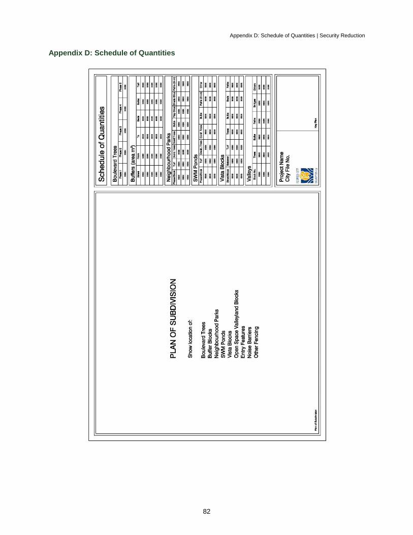
Appendix D: Schedule of Quantities | Security Reduction
82
Appendix D: Schedule of Quantities
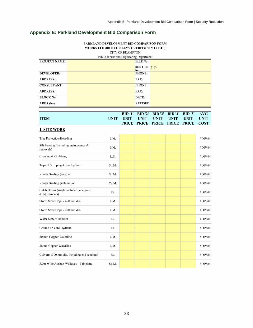
Appendix E: Parkland Development Bid Comparison Form | Security Reduction
83
Appendix E: Parkland Development Bid Comparison Form
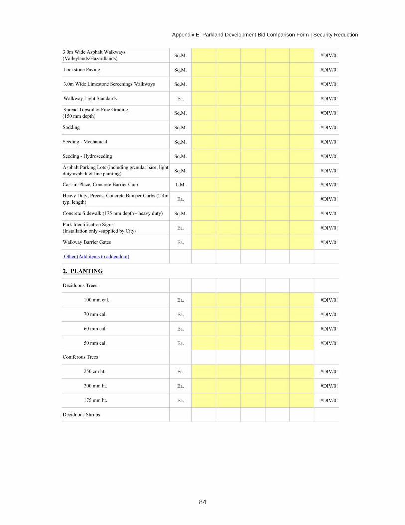
Appendix E: Parkland Development Bid Comparison Form | Security Reduction
84
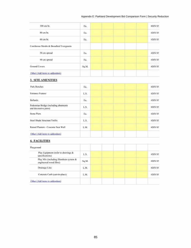
Appendix E: Parkland Development Bid Comparison Form | Security Reduction
85
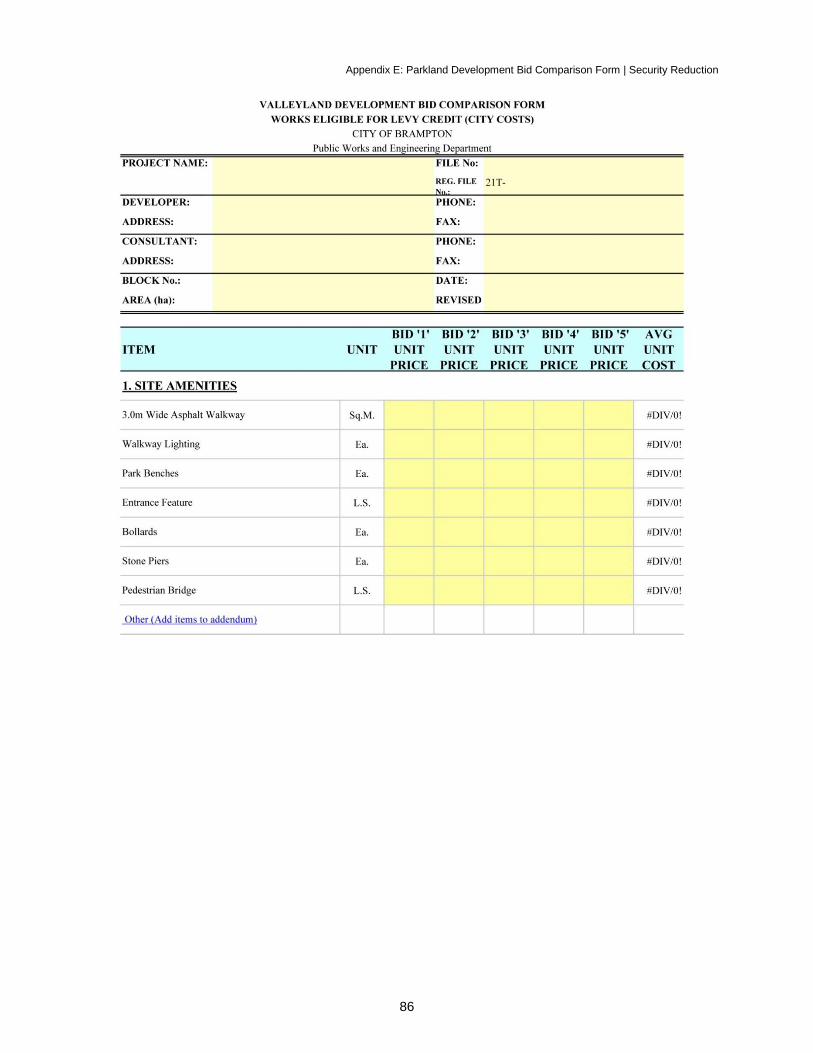
Appendix E: Parkland Development Bid Comparison Form | Security Reduction
86
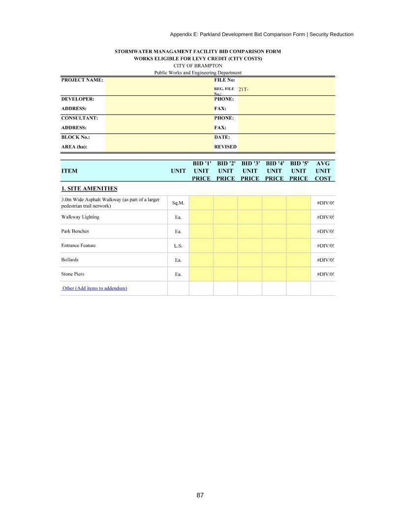
Appendix E: Parkland Development Bid Comparison Form | Security Reduction
87
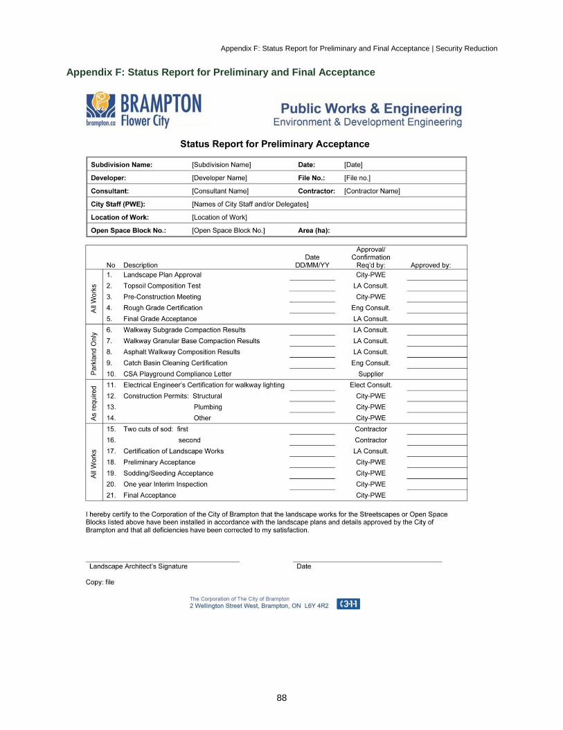
Appendix F: Status Report for Preliminary and Final Acceptance | Security Reduction
88
Appendix F: Status Report for Preliminary and Final Acceptance
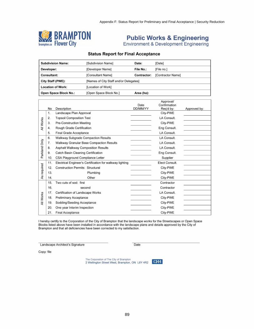
Appendix F: Status Report for Preliminary and Final Acceptance | Security Reduction
89
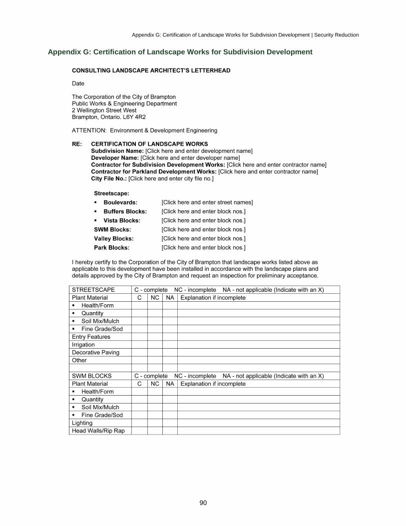
Appendix G: Certification of Landscape Works for Subdivision Development | Security Reduction
90
Appendix G: Certification of Landscape Works for Subdivision Development
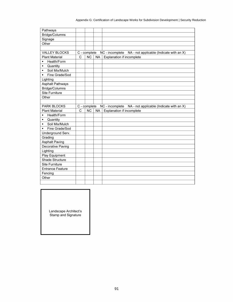
Appendix G: Certification of Landscape Works for Subdivision Development | Security Reduction
91
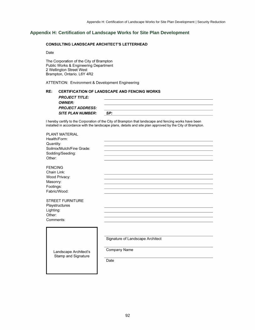
Appendix H: Certification of Landscape Works for Site Plan Development | Security Reduction
92
Appendix H: Certification of Landscape Works for Site Plan Development
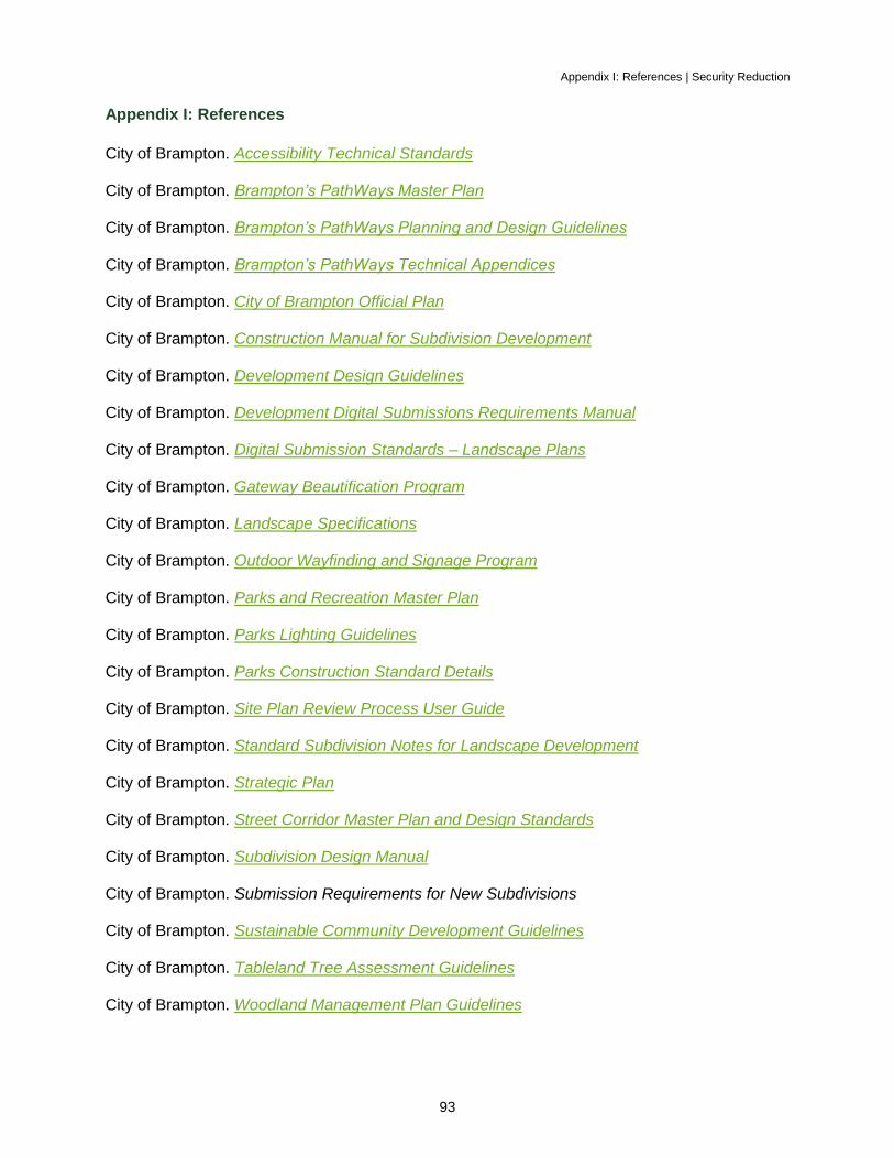
Appendix I: References | Security Reduction
93
Appendix I: References
City of Brampton. Accessibility Technical Standards
City of Brampton. Brampton’s PathWays Master Plan
City of Brampton. Brampton’s PathWays Planning and Design Guidelines
City of Brampton. Brampton’s PathWays Technical Appendices
City of Brampton. City of Brampton Official Plan
City of Brampton. Construction Manual for Subdivision Development
City of Brampton. Development Design Guidelines
City of Brampton. Development Digital Submissions Requirements Manual
City of Brampton. Digital Submission Standards – Landscape Plans
City of Brampton. Gateway Beautification Program
City of Brampton. Landscape Specifications
City of Brampton. Outdoor Wayfinding and Signage Program
City of Brampton. Parks and Recreation Master Plan
City of Brampton. Parks Lighting Guidelines
City of Brampton. Parks Construction Standard Details
City of Brampton. Site Plan Review Process User Guide
City of Brampton. Standard Subdivision Notes for Landscape Development
City of Brampton. Strategic Plan
City of Brampton. Street Corridor Master Plan and Design Standards
City of Brampton. Subdivision Design Manual
City of Brampton. Submission Requirements for New Subdivisions
City of Brampton. Sustainable Community Development Guidelines
City of Brampton. Tableland Tree Assessment Guidelines
City of Brampton. Woodland Management Plan Guidelines