Landsat Data Continuity Mission (LDCM) USGS Project · PDF fileLandsat Data Continuity Mission...
15
Landsat Data Continuity Mission (LDCM) USGS Project Status Report June 17, 2010 Dave Hair USGS LDCM Project Manager (acting) [email protected]
Transcript of Landsat Data Continuity Mission (LDCM) USGS Project · PDF fileLandsat Data Continuity Mission...

Landsat Data Continuity Mission (LDCM) USGS Project Status Report
June 17, 2010
Dave HairUSGS LDCM Project Manager (acting)[email protected]

U.S. Department of the Interior 2
Topics USGS LDCM Project Team Update Ground System Reviews Current Status Highlights Schedule & Ground System Builds Summary

U.S. Department of the Interior
USGS LDCM Project Organization
Contractor Key* EROS TSSC (SGT)
** EROS LDCC (SAIC)*** The Aerospace Corp
Chief SE – Jim Nelson*
Science Office – Tom Maiersperger*Cal/Val Lead – Ron Morfitt*
Landsat Science Team
Dr. Tom Loveland
Program Analyst – Connie HamannFinancial Analyst – Denny Tolliver
Flight Systems Dev SE – Grant Mah Vaughn Ihlen**DPAS Dev SE – Chris Engebretson
Todd Taylor*Steve Zahn**
I&T SE – Chris TorbertTom Piper*
USGS HQ LRS ProgramDr. Bruce Quirk
Tim Newman
NASA LDCM Project MgmtBill Ochs
Vicki DulskiKari Wulf***
USGS LDCM Project MgrDave Hair (Acting)
USGS GS LeadershipSteve Labahn
Doug Daniels***
Chief EngineerJim Lacasse
GS Development ManagerRod Pater
(DPAS, GNE, CAPE)
Flight Sys Mgr – Nicolaie TodiritaInt’l Grd Station Mgr – Steve LabahnOperations – Todd Taylor*
LDCM Project ScientistJohn Dwyer
Management & Financial Support
Dave Hair
Landsat OperationsBrian Sauer
Operations Transition MgrKaren Zanter (Acting)
Project and Systems Support Lead
Doug Daniels***
4-3

U.S. Department of the Interior
Ground System ReviewsCritical Design Reviews (CDRs) DateCollection Activity Planning Element (CAPE)Mission Operations Element (MOE)Ground Network Element (GNE)Data Processing and Archive System (DPAS)Ground System (GS)
Jan 2009Nov 2009Feb 2010Feb 2010Mar 2010
Mission May 2010
4
Test Readiness Reviews (TRRs) DateCollection Activity Planning Element (CAPE)Ground Network Element (GNE) TRR1Ground Network Element (GNE) TRR2
Dec 2009Apr 2010May 2010
Ground Readiness Test 1 (GRT 1) – Segments 1, 2, 3Ground Readiness Test 1 (GRT 1) – Segment 4Ground Readiness Test 2 (GRT 2) – Segments 1, 2Ground Readiness Test 3 (GRT 3)Ground Readiness Test 5 (GRT 5)Ground Readiness Test 6 (GRT 6)Ground Readiness Test 4a (GRT 4a)Ground Readiness Test 4b (GRT 4b)Ground Readiness Test 4b (GRT 4c)
Jun 2010Jul 2010
Aug 2010Aug 2010Dec 2010Feb 2011May 2011Aug 2011Jul 2012

U.S. Department of the Interior
Current Status Highlights Mitigated USGS budget shortfall
There is sufficient budget for USGS GS development and implementation activities with adequate spending profiles and reserves
• Final Implementation Agreement (FIA) between USGS and NASA redefined the exchange of funding responsibilities between GSFC-EROS
• USGS requested and received in the President’s budget additional LDCM development funding for FY’11-13
Authorized full implementation of TIRS critical design• Contract modifications were completed to support TIRS
implementation

U.S. Department of the Interior
Current Status Highlights Ground System
Schedule updates• Combined IAS releases 1 and 2
– Optimizes development schedule for L1 Processing• Adjusted CAPE schedule and combined CAPE 2.0 and 3.0 Builds
– Takes advantage of early test opportunities for key interfaces• Adjusted Ingest Release 1.0 schedule
– Accounts for potential changes to ancillary data definition Design Maturity
• Completed subsystem Engineering Peer Reviews (EPRs) focusing on critical design, interface definition, and integration and test
• Completed critical design reviews (CDRs) for all elements and GS• Continued to refine and mature the definition of all external interfaces,
particularly the Space to Ground Interface• Selected Ground Stations including NOAA Gilmore Creek and USGS EROS
Development/I&T• Completed CAPE 1.0 pre-ship review and subsequent delivery and integration
with the MOC• Completed FOT training of CAPE 1.0• Procured storage node hardware• Procured and received demodulators
6

U.S. Department of the Interior 7
Ground Network Element Equipment
TLM RX/Combiner
Exciters
IF Demod/Bit Syncs
IF Matrix Switch
CTP/LSIMSS
X-Band D/C& Test U/C
X-Band Fiber Optics
L5 DemodulatorTesting

U.S. Department of the Interior
GLC LGN Station Site Plan Overview

U.S. Department of the Interior
DPAS Operations Room

U.S. Department of the Interior
Computer Room Infrastructure
U.S. Department of the Interior
Servers
Power Panel
Storage
CR 2

U.S. Department of the Interior
Current Status Highlights Science
Science Team Science Office
• Delivered Phase 3 cloud cover algorithms and refined validation data sets• Science Data Management Plan is under configuration control
Cal/Val• Delivered draft OLI L0Rp data simulator to Ball Aerospace• Created OLI spectral simulator using Hyperion data• All OLI and TIRS phase 2 algorithms have been delivered to GS development• OLI & TIRS geometric and radiometric processing flows have been finalized• Constructed detailed algorithm delivery schedules linked to DPAS builds &
releases
Presenter
Presentation Notes
LTAP work now how active participation from Landsat Data Acquisition Manager I removed the off-nadir polar coverage – don’t want folks to think we are contemplating using off-nadir for survey mission The LST meeting on higher level data products (FCDRs and ECVs) led to the next two bulllets – emphasis on prototyping for end-use of LDCM data Not sure whether the CalVal algorithm schedules get addressed elsewhere, but the recent coordination between Science, SE, and PC has made significant strides in this area – kudos to TSSC and LDCC
U.S. Department of the Interior
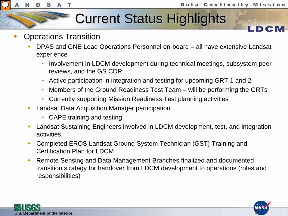
Current Status Highlights Operations Transition
DPAS and GNE Lead Operations Personnel on-board – all have extensive Landsat experience
• Involvement in LDCM development during technical meetings, subsystem peer reviews, and the GS CDR
• Active participation in integration and testing for upcoming GRT 1 and 2• Members of the Ground Readiness Test Team – will be performing the GRTs• Currently supporting Mission Readiness Test planning activities
Landsat Data Acquisition Manager participation• CAPE training and testing
Landsat Sustaining Engineers involved in LDCM development, test, and integration activities
Completed EROS Landsat Ground System Technician (GST) Training and Certification Plan for LDCM
Remote Sensing and Data Management Branches finalized and documented transition strategy for handover from LDCM development to operations (roles and responsibilities)
Presenter
Presentation Notes
LTAP work now how active participation from Landsat Data Acquisition Manager I removed the off-nadir polar coverage – don’t want folks to think we are contemplating using off-nadir for survey mission The LST meeting on higher level data products (FCDRs and ECVs) led to the next two bulllets – emphasis on prototyping for end-use of LDCM data Not sure whether the CalVal algorithm schedules get addressed elsewhere, but the recent coordination between Science, SE, and PC has made significant strides in this area – kudos to TSSC and LDCC

U.S. Department of the Interior
Ground System Summary Schedule

U.S. Department of the Interior
Schedule Logic Summary
Not all schedule items are shown here. Detailed test configurations are contained within the GRT Plan
U.S. Department of the Interior
Summary Completed critical design review Ground Readiness Tests underway Significant progress on ground system software, hardware, and
infrastructure