Landsat-based inventory of glaciers in western … · Landsat-based inventory of glaciers in...
11
Landsat-based inventory of glaciers in western Canada, 1985–2005 Tobias Bolch ⁎, Brian Menounos, Roger Wheate Natural Resources and Environmental Studies Institute, University of Northern British Columbia, 3333 University Way, Prince George, British Columbia Canada V2N 4Z9 abstract article info Article history: Received 27 January 2009 Received in revised form 21 August 2009 Accepted 22 August 2009 Keywords: Glacier inventory Glacier recession Landsat TM Western Canada Scaling method Band ratio Image classification We report on a glacier inventory for the Canadian Cordillera south of 60°N, across the two western provinces of British Columbia and Alberta, containing ~ 30,000 km 2 of glacierized terrain. Our semi-automated method extracted glacier extents from Landsat Thematic Mapper (TM) scenes for 2005 and 2000 using a band ratio (TM3/TM5). We compared these extents with glacier cover for the mid-1980s from high-altitude, aerial photography for British Columbia and from Landsat TM imagery for Alberta. A 25 m digital elevation model (DEM) helped to identify debris-covered ice and to split the glaciers into their respective drainage basins. The estimated mapping errors are 3–4% and arise primarily from seasonal snow cover. Glaciers in British Columbia and Alberta respectively lost -10.8 ± 3.8% and -25.4% ± 4.1% of their area over the period 1985– 2005. The region-wide annual shrinkage rate of -0.55% a -1 is comparable to rates reported for other mountain ranges in the late twentieth century. Least glacierized mountain ranges with smaller glaciers lost the largest fraction of ice cover: the highest relative ice loss in British Columbia (-24.0 ± 4.6%) occurred in the northern Interior Ranges, while glaciers in the northern Coast Mountains declined least (-7.7 ± 3.4%). © 2009 Elsevier Inc. All rights reserved. 1. Introduction Surface runoff from snowmelt and glaciers is an essential freshwater resource in western North America, especially during summer when the water demand is high (Barnett et al., 2005; Stahl and Moore, 2006). In western Canada glacier runoff is a vital component of surface flows to drainage basins of the eastern Rocky Mountains where runoff is used for agriculture, urban consumption, and industry. Hydroelectric power generation also relies on glacier runoff in glacierized basins of British Columbia (Moore et al., 2009). Finally, decline in glacier extent in western Canada and Alaska significantly contributes to sea level rise (Arendt et al., 2002; Larsen et al., 2007; Schiefer et al., 2007). The first attempt to inventory glaciers in western Canada used extents from 1:1,000,000 scale maps (Falconer et al., 1966). Later, the Glacier Inventory of Canada aimed to catalogue all glaciers at a scale of 1:500,000 as part of Canada's contribution to the International Hydrological Decade (1965–1974), but was never completed (Ommanney, 1980, 2002b). Pilot studies for the World Glacier Inventory catalogued limited regions of the Canadian Cordillera (Ommanney, 1971; Stanley, 1970). Only the glaciers on Vancouver Island and small regions of the Rocky and Coast mountains are included in the World Glacier Inventory (WGI, http://nsidc.org/data/ g01130.html). Results from these early glacier inventories are summarized by Haeberli et al. (1989) and Ommanney (2002b). Direct measurements of mass balance exist for only a few glaciers in Western Canada (Moore et al, 2009). Those data show a consistent pattern: slight positive mass balances in the mid 1970s, 1 or 2 years of positive mass balance at the end of the 1990s, and otherwise strong negative mass balance (WGMS, 2007). There have been recent efforts to document the area and volume loss of glaciers in western Canada, but none of these studies inventories all glaciers in British Columbia and Alberta (DeBeer and Sharp, 2007; Demuth et al., 2008; Larsen et al., 2007; VanLooy and Forster, 2008). Schiefer et al. (2008) presented a glacier inventory for glaciers of British Columbia based on extents obtained from aerial photography in the 1980s. However, their analysis included neither glaciers in Alberta nor more recent extents and changes in glacier cover. We expand on the work of Schiefer et al. (2008) and report on the approach to generate a glacier inventory from satellite imagery for the year 2005 for British Columbia and Alberta, Canada within the time frame of less than 1 year. We compare these results to earlier extents derived from aerial photography to report on area loss over this 20 year period. We further utilize satellite imagery from the year 2000 for 50% of our study area to extend the temporal coverage of our analysis. The inventory data generated are available through the Global Land Ice Measurements from Space (GLIMS) database (Bolch et al., 2008b). 2. Study area and glaciers in western Canada Our study focuses on glaciers in the Canadian Cordillera south of 60°N, a broad, mountainous region covering roughly 1,000,000 km 2 that can be subdivided into Western, Interior and Eastern mountain Remote Sensing of Environment 114 (2010) 127–137 ⁎ Corresponding author. Current address: Institut für Kartographie, Technische Universität Dresden, 01062 Dresden, Germany. E-mail address: [email protected] (T. Bolch). 0034-4257/$ – see front matter © 2009 Elsevier Inc. All rights reserved. doi:10.1016/j.rse.2009.08.015 Contents lists available at ScienceDirect Remote Sensing of Environment journal homepage: www.elsevier.com/locate/rse
-
Upload
trinhtuong -
Category
Documents
-
view
222 -
download
0
Transcript of Landsat-based inventory of glaciers in western … · Landsat-based inventory of glaciers in...

Remote Sensing of Environment 114 (2010) 127–137
Contents lists available at ScienceDirect
Remote Sensing of Environment
j ourna l homepage: www.e lsev ie r.com/ locate / rse
Landsat-based inventory of glaciers in western Canada, 1985–2005
Tobias Bolch ⁎, Brian Menounos, Roger WheateNatural Resources and Environmental Studies Institute, University of Northern British Columbia, 3333 University Way, Prince George, British Columbia Canada V2N 4Z9
⁎ Corresponding author. Current address: InstitutUniversität Dresden, 01062 Dresden, Germany.
E-mail address: [email protected] (T. Bolc
0034-4257/$ – see front matter © 2009 Elsevier Inc. Aldoi:10.1016/j.rse.2009.08.015
a b s t r a c t
a r t i c l e i n f oArticle history:Received 27 January 2009Received in revised form 21 August 2009Accepted 22 August 2009
Keywords:Glacier inventoryGlacier recessionLandsat TMWestern CanadaScaling methodBand ratioImage classification
We report on a glacier inventory for the Canadian Cordillera south of 60°N, across the two western provincesof British Columbia and Alberta, containing ~30,000 km2 of glacierized terrain. Our semi-automated methodextracted glacier extents from Landsat Thematic Mapper (TM) scenes for 2005 and 2000 using a band ratio(TM3/TM5). We compared these extents with glacier cover for the mid-1980s from high-altitude, aerialphotography for British Columbia and from Landsat TM imagery for Alberta. A 25 m digital elevation model(DEM) helped to identify debris-covered ice and to split the glaciers into their respective drainage basins.The estimated mapping errors are 3–4% and arise primarily from seasonal snow cover. Glaciers in BritishColumbia and Alberta respectively lost −10.8±3.8% and −25.4%±4.1% of their area over the period 1985–2005. The region-wide annual shrinkage rate of −0.55% a−1 is comparable to rates reported for othermountain ranges in the late twentieth century. Least glacierized mountain ranges with smaller glaciers lostthe largest fraction of ice cover: the highest relative ice loss in British Columbia (−24.0±4.6%) occurred inthe northern Interior Ranges, while glaciers in the northern Coast Mountains declined least (−7.7±3.4%).
für Kartographie, Technische
h).
l rights reserved.
© 2009 Elsevier Inc. All rights reserved.
1. Introduction
Surface runoff from snowmelt and glaciers is an essentialfreshwater resource in western North America, especially duringsummer when the water demand is high (Barnett et al., 2005; Stahland Moore, 2006). In western Canada glacier runoff is a vitalcomponent of surface flows to drainage basins of the eastern RockyMountains where runoff is used for agriculture, urban consumption,and industry. Hydroelectric power generation also relies on glacierrunoff in glacierized basins of British Columbia (Moore et al., 2009).Finally, decline in glacier extent in western Canada and Alaskasignificantly contributes to sea level rise (Arendt et al., 2002; Larsenet al., 2007; Schiefer et al., 2007).
The first attempt to inventory glaciers in western Canada usedextents from 1:1,000,000 scale maps (Falconer et al., 1966). Later, theGlacier Inventory of Canada aimed to catalogue all glaciers at a scale of1:500,000 as part of Canada's contribution to the InternationalHydrological Decade (1965–1974), but was never completed(Ommanney, 1980, 2002b). Pilot studies for the World GlacierInventory catalogued limited regions of the Canadian Cordillera(Ommanney, 1971; Stanley, 1970). Only the glaciers on VancouverIsland and small regions of the Rocky and Coast mountains areincluded in the World Glacier Inventory (WGI, http://nsidc.org/data/g01130.html). Results from these early glacier inventories are
summarized by Haeberli et al. (1989) and Ommanney (2002b). Directmeasurements ofmass balance exist for only a few glaciers inWesternCanada (Moore et al, 2009). Those data show a consistent pattern:slight positive mass balances in the mid 1970s, 1 or 2 years of positivemass balance at the end of the 1990s, and otherwise strong negativemass balance (WGMS, 2007).
There have been recent efforts to document the area and volume lossof glaciers in western Canada, but none of these studies inventories allglaciers in British Columbia and Alberta (DeBeer and Sharp, 2007;Demuth et al., 2008; Larsen et al., 2007; VanLooy and Forster, 2008).Schiefer et al. (2008) presented a glacier inventory for glaciers of BritishColumbia based on extents obtained from aerial photography in the1980s. However, their analysis included neither glaciers in Alberta normore recent extents and changes in glacier cover.
We expand on the work of Schiefer et al. (2008) and report on theapproach to generate a glacier inventory from satellite imagery for theyear 2005 for British Columbia and Alberta, Canada within the timeframe of less than 1 year. We compare these results to earlier extentsderived from aerial photography to report on area loss over this 20 yearperiod.We further utilize satellite imagery from the year 2000 for 50%ofour study area to extend the temporal coverage of our analysis. Theinventory data generated are available through the Global Land IceMeasurements from Space (GLIMS) database (Bolch et al., 2008b).
2. Study area and glaciers in western Canada
Our study focuses on glaciers in the Canadian Cordillera south of60°N, a broad, mountainous region covering roughly 1,000,000 km2
that can be subdivided into Western, Interior and Eastern mountain

128 T. Bolch et al. / Remote Sensing of Environment 114 (2010) 127–137
systems. The Insular, Coast, and St. Elias mountains encompass theWestern System. The Interior System in the south contains thePurcell, Selkirk, Cariboo, and Monashee mountains between 119–115°W longitude and 49–54°N latitude. The Interior Plateau dividesmountains of the southern Interior from their counterparts in thenorth: the Hazelton, Skeena, Cassiar, and Omineca mountains. TheEastern System is defined by the Rocky Mountains that continuenorth from the US and terminate south of the Liard River. Local relieftypically exceeds 600 m for many of these ranges, and some of thehighest peaks in the Rocky, St. Elias, and Coast mountains exceed4000 m above sea level (m a.s.l.). We subdivide the mountains intonine regions based on natural boundaries (Fig. 1). Similar climate andglacier characteristics typify these regions, and they conform to theregions presented by Schiefer et al. (2007).
Located in the zone of mid-latitude Westerlies, strong precipita-tion gradients are common in the study area with total precipitationdeclining from west to east. Maximum precipitation occurs in theCoast Mountains during the winter months due to cyclonic activities,while summer precipitation is predominant in the Rocky Mountains(Barry, 2008). Local- to regional-scale precipitation patterns areheavily influenced by topographic factors, which in turn impactglacier mass balance (Letréguilly, 1988; Shea et al., 2004).
Glaciers occupied about 30,000 km2 in the 1980s in BritishColumbia and Alberta based on provincial and federal mappingdata; this estimate of glacier extent represents about 23% of the NorthAmerican and 4% of the world's non-polar ice coverage (Schiefer et al.,2007; Williams and Ferrigno, 2002). Glacier types in the CanadianCordillera range from large ice fields to valley and small hanging
Fig. 1. Study area showing the sub-regions, path and row of the uti
glaciers (Schiefer et al., 2008). Debris covers the ablation zone of somelarge glaciers in many mountain ranges (Ommanney, 2002a), androck glaciers occur in continental sites. Rock glaciers, however, are notinventoried in the present study. The mean glacier elevation can belower than 1250 m a.s.l. in the northern Coast Mountains but oftenexceeds 2750 m a.s.l. in the southern Rocky Mountains (Schiefer et al.2007, 2008). The predominant aspect of the upper glacier areas isnorth and north-east (Schiefer et al. 2008).
3. Methods and data
3.1. Glacier mapping: previous applications
Semi-automated multispectral glacier mapping methods includesupervised classification (Aniya et al., 1996; Gratton et al., 1990;Sidjak and Wheate, 1999), thresholding of ratio images (Paul et al.,2002; Rott, 1994) and the Normalised Difference Snow Index (NDSI)(Hall et al., 1995; Racoviteanu et al., 2008). Thresholding of ratioimages is a robust and time effective approach compared to manualdigitization and also enables identification of snow and ice in shadow(Paul and Kääb, 2005; Paul et al., 2003; Bolch and Kamp, 2006). TheRED/SWIR ratio (e.g. TM3/TM5) has the advantage over the NIR/SWIR ratio (e.g. TM4/TM5) in that it works better in shadows andwith thin debris-cover (Andreassen et al., 2008; Paul and Kääb,2005). However, this ratio method suffers from two primarylimitations: the recorded ratio of reflection of water bodies is similarto snow and ice, and in common with other automated methodsbased on multispectral data, areas of debris-covered ice are not
lized Landsat scenes, and the coverage of the glacier inventory.

129T. Bolch et al. / Remote Sensing of Environment 114 (2010) 127–137
distinguished due to the spectral similarity with surroundingbedrock (Bolch et al., 2008a).
In general, water bodies are detectable using the NormalisedDifference Water Index (NDWI), but turbid lakes and areas in castshadow are problematic (Huggel et al., 2002). We tested the NDWImethod for the northern Rocky Mountains and encountered the sameproblems. We found that manual editing of the glacier polygons toexclude misclassified water bodies was superior to any automatedmethod and involved less time. Promising approaches to map debris-covered glaciers include those based on thermal information (Ranziet al., 2004), a slope threshold in combination with neighbourhoodanalysis and change detection (Paul et al., 2004a), morphometricanalysis (Bishop et al., 2001; Bolch and Kamp, 2006) or a combinationof thermal information and morphometric parameters (Bolch et al.,2007). However, these methods suffer from high errors (>5%)requiring editing during post processing, a DEM of sufficient accuracyand only successfully operate on small regions where the methodol-ogy can be optimized.
3.2. Data
The British Columbia Government produced glacier extents and a25-m digital elevation model (DEM) under the Terrain ResourceInventory Management (TRIM) program at a scale of 1:20,000. TRIMwas based on aerial photographymostly acquired during late summer1982–1988 (Geographic Data British Columbia, http://ilmbwww.gov.bc.ca/bmgs/pba/trim). We generated a 25 m DEM for western Albertafrommass points with a spacing varying from 25 m and up to 80 m inthe Banff and Jasper national parks, and breaklines using a TINalgorithm. The TIN was then converted into a grid with a resolution of25 m to match the TRIM DEM.
The (median date) 1985 glacier inventory for British Columbiauses the polygons from TRIM (Schiefer et al., 2007). Glacier extents forAlberta from the Canadian National Topographic DataBase (NTDB)were available, but are mainly from 1994 and contain largediscrepancies between glacier polygons and glaciers revealed insatellite imagery from similar acquisition years (e.g. glaciers aremapped where no snow and ice can be identified on the imagery).
Our glacier inventory employed orthorectified Landsat imagery asa compromise between the large field of view (180×170 km) andspatial resolution (30 m). The British ColumbiaMinistry of Forests andRange provided Landsat 5 TM imagery from 2003–2007, rectified tobetter than ±15 m root mean squared error (RMSE). We selected 41scenes from the years 2004 to 2006 for the 2005 inventory and twoscenes acquired in 2003 and 2007 (Appendix A and Bolch et al.,2008b). Landsat coverage with no clouds and minimal seasonal snowwas available for all regions, and most of the selected scenes wereacquired in late summer.
We also used orthorectified Landsat images (L1G) from the GlobalLand Cover Facility (GLCF: http://www.landcover.org) and purchasedother scenes to map the 1985 glacier extents in Alberta, demarcateglacier extents in 2000 for selected regions, and evaluate glacierpolygons from the TRIM program. The reported positional accuracy ofthe orthorectifiedGLCF scenes is±50m(Tucker et al., 2004), and visualinspection indicated a good fit with the TRIM glacier outlines. However,we commonly observed a shift of 15 m, and a maximum shift of 60 moccurred near the uppermost areas of steep terrain. As a consequence ofthese positional errors and seasonal snow on some of the GLCF scenesfrom 2000, we could not successfully indentify all small, high-altitudeglaciers. Orthorectification of the purchased scenes produced rootmeansquare errors (RMSE) of less than30 m.Reportedhorizontal and verticalerrors of the DEM are ±10 and ±5 m, respectively (British ColumbiaMinistry of Environment, Land and Parks, 1992). However, highervertical errors and artefacts such as striping occur in the accumulationareas of some glaciers due to poor contrast in the aerial photography(Schiefer et al., 2007; VanLooy and Forster, 2008).
3.3. Glacier identification
3.3.1. Glacier outlines of 1985 for British ColumbiaOur 1985 inventory for British Columbia uses glacier polygons
from the provincial TRIM program. In some cases, however, thesepolygons contain substantial errors that stem from interpretationerrors, presence of debris cover, and seasonal snow. Debris-coveredice, for example, was often incorrectly mapped on large glaciertongues. These mapping errors were identified based on theunrealistic shape of mapped glacier termini and through comparisonwith satellite imagery. Additional information was provided by thehillshaded TRIM-DEM (sun elevation angle: 45°, azimuth: 315°). Wealso utilized in a few instances morphometric parameters such asslope, plan and profile curvature to help identify landforms (Schmidtand Dikau, 1999), as marked concavity can represent the transition ofthe glaciers to surrounding moraines or forefield (Bolch and Kamp2006). The identification of errors due to seasonal snow cover,especially for small glaciers presented a greater challenge than debris-cover. We used qualitative measures such as irregular glacier shapesor large deviations between glacier areas in 1985 and 2005 to identifyglaciers that required further scrutiny. We manually improved thoseerroneous polygons via Landsat TM scenes from approximately thesame year.
3.3.2. Glacier outlines of 2005We selected the TM3/TM5 band ratio for glacier mapping based
on previous experience and tests that we completed for glaciers inthe northern Rocky Mountains and Interior Ranges (discussedbelow). For the entire study area, we used our improved BritishColumbia TRIM glacier outlines as a mask to minimize misclassifi-cation due to factors such as seasonal snow. When using this mask,we assumed that glaciers did not advance between 1985 and 2005,an assumption that holds for practically all non-tidewater glaciers inwestern North America (Moore et al., 2009). The mask alsomaintained consistency in the location of the upper glacier boundaryand the margins of nunataks. This consistency is important in case ofseasonal snow that hampers correct identification of the upperglacier boundary. In addition, all snow and ice patches that were notconsidered to be perennial ice in the TRIM data were eliminated andhence, we minimize deviations in glacier areas that could arise frominterpretative errors or major variations in snow cover (e.g. Paul andAndreassen, 2009).
We mapped only glaciers larger than 0.05 km2 as a smallerthreshold would include many features that were most likely snowpatches. We could not justify the costs in terms of effort and highrelative error to map glaciers at a larger scale, especially given thespatial extent of our study. We identified internal single pixel ‘holes’in the glacier polygons based on an area threshold and deleted themas these are usually misclassified pixels due to glacier debris. Theresulting glacier polygons were visually checked for gross errorsbased on the procedures previously discussed, and overall, less than5% of the glaciers were manually improved.
3.3.3. Glacier outlines of 1985 for Alberta and of 2000 for selected areasWe generated the mid-1980s glacier extents for Alberta from
Landsat TM scenes using the same method as described in theprevious section. As no glacier polygons from earlier dates wereavailable as a mask, we used the area threshold of 0.05 km2 andthe Normalised Difference Vegetation Index (NDVI) to reducemisclassified pixels. Nevertheless, substantially more time and effortwas required to generate these extents for Alberta than editing theavailable mid-1980s glacier extents for a comparable area in BritishColumbia.
Wealso generatedglacier outlines for 2000 for selected representativeregions in our study: the southern Coast Mountains, the southernInterior Ranges, the southern Rocky Mountains, the northern Rocky

130 T. Bolch et al. / Remote Sensing of Environment 114 (2010) 127–137
Mountains and a portion of the northern Coast Mountains (Fig. 1).While larger glaciers could be correctly delineated, it was difficult todistinguish small areas of high elevation glacier ice from surroundingsnow in several regions, due to remaining seasonal snow cover. Forthis dataset, more than 5% of the polygons had to be manuallycorrected and the overall workloadwas similar to the 2005 inventorydue to more manual effort although fewer polygons had to bechecked.
3.3.4. Glacier drainage basinsWe derived glacier drainage basins using the DEM and a buffer
around each glacier (Fig. 2); this approach can be used for any timeperiod and extents, in contrast to methods linked to specific glacieroutlets, and thus to a morphology for a given period of time (Manley,2008; Schiefer et al., 2008). The optimum buffer size varied accordingto glacier size and the investigated time period: for this study, it variedfrom 1 to 1.5 km. Our method assumes no migration of flow dividesthrough time. After identifying the optimum buffer size for eachregion, the DEM was clipped to this buffer. The next step was thecalculation of glacier basins by hydrological analysis. The pour pointsare the lowermost points at the edge of the clipped DEM. Wesubsequently converted the calculated basin grid into polygons whichrepresent glacier drainage basins and these polygonswere used to clipthe glaciers. These basins do not necessarily contain only one glacier,but could also contain several smaller glaciers. However, subsequent
Fig. 2. Flow chart showing the process of
Fig. 3. Sample of delineated glacier drainage basins. Red ellipses indicate examples
change analysis is based on each glacier. The main errors of thisapproach are due to DEM artefacts in the accumulation zones (Fig. 3)and also where small glaciers without a distinctive tongue could notbe separated from adjacent, larger glaciers. We manually improvedgross errors with the help of the shaded relief data and the Landsatscenes. Where small parts of glaciers reached over a mountain ridge,we treated these hydrologically distinct ice bodies as separate glaciersif they exceeded 0.05 km2. Smaller snow and ice polygons wereomitted, and the omitted area was less than 0.3%.
3.3.5. Glacier inventory, glacier parameters, and change analysisWhere glaciers extend across the borders with Alaska (USA) and
Yukon Territory (Canada), we included them in both 1985 and 2005inventories if the greater part of the glacier is in British Columbia andif we had access to suitable Landsat imagery for both dates. Ourcriteria excluded ca. 660 km2 ice covered area in British Columbia, butit included about 1400 km2 of ice in Alaska and 100 km2 in YukonTerritory.
We used the GLIMS identification system based on glaciercoordinates (Raup and Khalsa, 2007). However, we introduced a prefixthat represents the hydrological basin system following the officialnumbering of the Water Survey of Canada (http://www.wsc.ec.gc.ca).Characteristic parameters (area, elevation, slope, aspect) for each glacierwere obtained from the 25m DEM. The final database includes thefollowing: WC2N_ID, GLIMS_ID, name (if existing), province, region,
deriving the glacier drainage basins.
of uncertain ice divides due to the erroneous DEM in the accumulation zones.

Table 1Comparison of the outlines of the 2005 glacier inventory and independently digitizedoutlines based on aerial photography of the same year (Matt Beedle, pers. comm. 2007).
Glacier/Icefield Areaa
[km2]Areab
[km2]Deviation[km2]
Deviation[%]
(Region)
Castle Creek Glacier (Southern Interior) 9.66 9.90 +0.24 +2.4Lloyd George Ice Field(Northern Rocky Mountains)
48.27 49.02 +0.75 +1.5
Peyto Glacier (Southern Rocky Mountains) 10.69 10.51 −0.18 −1.7
Debris-cover was manually corrected for Peyto Glacier and one glacier at Lloyd GeorgeIcefield.
a From aerial photography.b Satellite imagery.
131T. Bolch et al. / Remote Sensing of Environment 114 (2010) 127–137
source time, area, minimum, maximum, median, and mean elevation,mean slope and aspect. We calculated these glacier attributes in a GISand used sines and cosines to determine aspect (Schiefer et al., 2008).Subsequent change analysis was based on the glacier extents of 1985and their identificationnumber because someglaciersdisintegratedandnew IDs had to be added for the 2000 and 2005 inventories.
3.3.6. Error estimationSources of potential error in area estimates include the following
factors:
a) Method of glacier delineation (ea): Previous studies using a bandratio method to map glaciers indicate an error of ca. ±2% fordebris-free glaciers (Bolch and Kamp, 2006; Paul et al., 2003). Ourtests based on comparison with independently generated outlinesfrom aerial photography confirm the magnitude of this error term
Fig. 4. Deviation of glacier outlines digitized manually from high resolution aerial photogautomated approach; left: Peyto Glacier in the southern Rocky Mountains, right: Castle CrDrainage basin delineation, B: Different interpretation of snow cover, C: Internal rocks, D: D
for the present study (Table 1, Fig. 4). The margins of debris-covered glaciers were manually improved, but due to the size ofthe study area and the number of glaciers, some smaller debris-covered glaciers may not have been identified. An additional errorof ±0.5%was added to account for themore difficult delineation ofdebris-covered glacier tongues. This error term is based on randomtests over the study area wherewe compared the improved glacieroutlines based on the Landsat data with higher resolution aerialphotos. Hence, we estimate the mapping error to be ±2.5%.
b) Error in co-registration and glacier size (eb): Visual checksconfirmed the accuracy of the 2005 co-registered imagery andmean deviation was within ±15 m, compared to the given ±50 m for the 2000 GLCF imagery. We estimate this error termbased on a buffer for each glacier similar to themethod suggestedby Granshaw and Fountain (2006). The buffer size was chosen tobe half of the estimated shift caused by misregistration as onlyone side can be affected by the shift and the resulting cut off bythe TRIM outlines. This method includes the relative higher errorof small polygons as a small glacier has relatively more edgepixels.
c) Scene quality, clouds, seasonal snow, and shadow (ec): Seasonalsnow introduced errors in area determination of small, highaltitude glaciers, but there were negligible errors from clouds andshadows. We estimate an error of ±3% for scenes that have late-lying snow, based on tests, wherewe visually compared automatedderived outlines with manually improved ones, conducted on TMscenes across the study area. This error was added to each studyarea based on the fraction of scenes with seasonal snow. Forexample, the two scenes covering the northern Rocky Mountainshad no seasonal snow, hence no error term was applied, whereasfour of the six scenes of the central Coast Mountains were affectedby seasonal snow, and an error ±2% was added.
raphy (Matt Beedle, pers comm., 2007) and derived from Landsat TM data using oureek Glacier in the southern Interior Ranges; the arrows indicate problematic areas: A:ebris-cover.

132 T. Bolch et al. / Remote Sensing of Environment 114 (2010) 127–137
The total error is thus estimated as the root sum square of eacherror term.
4. Results
4.1. Errors in TRIM outlines
Errors in the original TRIM glacier outlines occur in all regions, butglacier extent was significantly overestimated due to seasonal snow inthree regions: Vancouver Island (TRIM data, original: 28.8 km2;improved: 18.2 km2, deviation: −36.9%), central Coast Mountains(2426.8 km2: 2077.9 km2, −14.4%), southern Interior Ranges(2359.4 km2: 2252.6 km2, −4.5%). The southern Coast Mountainshad the largest number of errors due to debris cover but overall, thiserror was small (<0.1%). Our revised extents from 1985 for BritishColumbia contain about 1.5% less ice than the original mapped TRIMglacier extents.
4.2. Regional glacier characteristics and glacier recession
Glaciers with an area between 0.1 and 1.0 km2 represent themost frequent size class in all regions except the St. Elias Moun-
Fig. 5. Diagrams showing the number and covered area for eight different size classes of t1: 0.05–0.1 km2, 2: 0.1–0.5 km2, 3: 0.5–1.0 km2, 4: 1.0–5.0 km2, 5: 5.0–10 km2, 6: 10–50 km
tains, where a few large glaciers (>100 km2) cover a large area(Fig. 5). In most other regions, the size class between 1.0 and5.0 km2 covers the largest fraction of terrain. In 1985, mean glaciersize varied between 0.3 km2 on Vancouver Island and 7.0 km2 in theSt. Elias Mountains. Further glacier characteristics are presented bySchiefer et al. (2007, 2008) and are summarized in the introduction(section 1).
We summarize the area changes for the periods 1985–2005,1985–2000 and 2000–2005 based on our defined mountain regions(Table 2, with examples illustrated in Fig. 6). Glacierized terraindecreased from 30,063.0 km2 in 1985 to 26,728.3±962 km2
(−11.1±3.8%) until 2005. Approximately 2000 of the original~14,300 glaciers in the study area disintegrated and as a result, theestimated number of glaciers increased by ~3000 between 1985 and2005. Approximately 300 glaciers disappeared during the sameperiod of time.
Analysis of the corresponding change in glacier area consistentlyindicates a greater percentage loss for small glaciers across the studyarea than for large ones (Fig. 7), although the absolute loss is muchlower than for the larger glaciers. The largest total loss is for glaciers inthe 1–5 km2 size class, which also has the largest number of glaciers(~4900). In contrast to the relative ice loss, the absolute area loss in
he glaciers for the ten subregions (year 1985). The size classes are defined as follows:2, 7: 50–100 km2, 8: >100 km2.

Table2
Glacier
area
andarea
chan
ges,19
85–20
05fortheinve
ntoryof
Western
Cana
da.
Region
Area19
85[km
2]
Area20
00[km
2]
Area20
05[km
2]
Num
berof
Glaciers(85)
Num
berof
Glaciers(05)
Mea
nsize
(85)
[km
2]
Areach
ange
85-05[km
2]
Ann
ualcha
nge
85-05[km
2a−
1]
Areach
ange
85-05[%]
Areach
ange
85-00[%]
Areach
ange
00-05[%]
Ann
ualrate
85-05[%
a−1]
Ann
ualrate
85-00[%a−
1]
Ann
ualrate
00-05[%a−
1]
SE36
15.6
(87)
Noda
ta33
30.4
(04)
510
647
7.01
−28
5.2±
122.6
−15
.9±
6.8
−7.9±
3.4
Noda
taNoda
ta−
0.44
±.0.19
Noda
taNoda
taNC
10,863
.2(8
3)39
83.0
(99)
10,029
.1(0
5)31
3137
463.47
−83
4.1±
367.0
−37
.9±
16.7
−7.7±
3.4
−4.4±
4.1
−3.1±
4.1
−0.35
±0.15
−0.27
±0.25
−0.44
±0.58
2000
cv.
4164
.2(8
3)38
55.0
(05)
−30
9.2±
133.0
−7.4±
3.4
−0.34
±0.15
CC20
77.9
(87)
Noda
ta16
25.0
(05)
2293
2962
0.91
−45
2.9±
101.9
−25
.2±
4.8
−21
.8±
4.9
Noda
taNoda
ta−
1.21
±0.27
Noda
taNoda
taSC
7911
.7(8
7)74
09.4
(00)
7097
.3(0
4)36
2045
072.10
−81
4.4±
300.5
−47
.9±
14.4
−10
.3±
3.8
−6.3±
4.5
−3.9±
4.5
−0.61
±0.22
−0.49
±0.34
−0.79
±0.86
VI
18.2
(87)
Noda
ta14
.5(0
5)61
650.30
−3.4±
1.24
−0.20
±0.04
−20
.0±
7.3
Noda
taNoda
ta−
1.11
±0.40
Noda
taNoda
taNI
696.9(8
5)Noda
ta52
9.9(0
5)72
910
830.96
−16
7.0±
31.7
−8.65
±1.12
−24
.0±
4.6
Noda
taNoda
ta−
1.20
±0.23
Noda
taNoda
taSI
2252
.6(8
5)20
34.1
(01)
1910
.4(0
6)18
5523
041.21
−34
2.2±
98.9
−16
.3±
3.1
−15
.2±
4.4
−10
.5±
5.1
−5.5±
5.3
−0.72
±0.21
−0.66
±0.32
−0.92
±0.89
NR
496.8(8
6)44
8.6(0
1)41
8.0(0
6)46
454
01.07
−78
.8±
22.8
−3.94
±0.74
−15
.9±
4.6
−9.7±
4.9
−6.2±
5.2
−0.79
±0.23
−0.69
±0.35
−1.03
±0.86
CR50
9.1(8
6)Noda
ta42
0.0(0
6)36
146
21.41
−89
.1±
20.9
−4.46
±0.82
−17
.5±
4.1
Noda
taNoda
ta−
0.88
±0.21
Noda
taNoda
taSR
1587
.0(8
4)14
47.7
(00)
1351
.7(0
6)10
8912
711.46
−23
5.3±
65.2
−10
.70±
2.3
−14
.8±
4.1
−7.5±
5.2
−7.2±
5.7
−0.67
±0.19
−0.47
±0.36
−1.21
±0.96
Who
leInve
ntory
30,063
.026
,728
.314
,329
17,595
2.10
−33
35.8±
1141
.9−16
6.74
±48
.1−11
.1±
3.8
Noda
taNoda
ta−0.55
±0.19
Noda
taNoda
ta20
00cv
.16
,389
.815
,322
.814
,615
.2n.c.
n.c.
2.10
−17
74.6
88.73
−10
.8±
3.5
−6.5±
4.5
−4.3±
4.6
−0.54
±0.17
−0.43
±0.30
−0.86
±0.88
BCon
ly28
,232
.825
,218
.213
,403
16,428
2.11
−30
56.0±
990.4
−15
2.8±
41.0
−10
.8±
3.5
Noda
taNoda
ta−
0.54
±0.17
Noda
taNoda
taAlberta
1053
.578
5.7
926
1167
1.14
−26
7.9±
43.2
−13
.39±
1.8
−25
.4±
4.1
Noda
taNoda
ta−
1.27
±0.20
Noda
taNoda
ta
Region
code
s:SE
:St.E
lias,NC:
northe
rnCo
ast,CC
:centralC
oast,S
C:southe
rnCo
ast,VI:Van
couv
erIsland
,NI:no
rthe
rnInterior,S
I:southe
rnInterior,N
R:no
rthe
rnRo
ckies,CR
:centralR
ockies,S
R:southe
rnRo
ckies.
Theda
tesin
bracke
ts(abb
reviated
tothelast
2digits)represen
ttheav
erag
edmea
nof
theacqu
isitionda
tesforthedifferen
tregion
s.Th
erow
forW
hole
Inve
ntoryis
setin
bold
tohigh
light
overalls
tatistics.20
00cv
.refersto
thepo
rtionmap
pedfortheye
ar20
00.
133T. Bolch et al. / Remote Sensing of Environment 114 (2010) 127–137
the northern Coast Mountains (−834.1±367.0 km2) was five timeshigher than in the northern Interior Ranges (−167.0±31.7 km2),given the former's larger glacierized area. Glaciers on the easternslope of the southern Rocky Mountains lost 25.4±4.1% of their area,more than twice as much as the glaciers west of the ContinentalDivide (10.8±3.5%). The 2000–2005 shrinkage rate was higher thanthe 1985–2000 rate but not statistically significant given the largeerror term and short period of time over which area change wasassessed. The highest and lowest loss rates for the period 2000–2005occurred in the southern Rocky Mountains (−1.21±0.96%) andnorthern Coast Mountains (−0.44±0.58%).
In order to control for differences in glacier area, we comparechanges in glacier cover for different size classes (Fig. 8). The highestpercent area losses occur in the northern Interior, central Rocky, andcentral Coast mountains. The lowest losses occur in the St. Elias, thenorthern and southern Coast mountains, and also for the size class0.5–1.0 km2 on Vancouver Island.
Overall, north and southwest facing glaciers shrank most.However, these glaciers are typically the smallest. Comparing thesame size class shows similar area losses for all aspects (Fig. 9). Arealoss for the size class 1–5 km2, for example, only varies between−13.3 (SE) and−15.4% (N), and so the relative area change by aspectis minor. There is also no significant influence of median glacierelevation on shrinkage rate and absolute ice loss across the study area(Fig. 10).
5. Discussion
5.1. Glacier inventory derived by remote sensing
Ourmethodology enabled us to compile amulti-temporal glacierinventory using Landsat imagery and other digital data over a largeregion containing more than 15,000 glaciers within a time frame ofless than 1 year. Glacier mapping based on the image-ratio methodcan be used for glacierized regions that require dozens of Landsatscenes, as effectively as for single Landsat images as utilized byseveral other studies (e.g. Andreassen et al., 2008; Bolch, 2007; Paulet al., 2003; Paul and Kääb, 2005). The time commitment per scenewas less than that needed for a single scene as several steps canbe done for the whole dataset (e.g. splitting the glaciers,calculating glacier variables). However, additional effort isnecessary for merging the polygons obtained from differentscenes. We found that existing methods to map debris-coveredglaciers and glacial lakes were not feasible given the extensivespatial domain of our study area. We believe that our semi-automated method is faster than manual digitization for regions ofextensive ice cover and for multi-temporal glacier inventorieswhere an error of ±3–4% is acceptable. Time efficiency and smallerrors are important prerequisites for glacier monitoring in theGlobal Terrestrial Network for Glaciers (GTN-G) as part of theglobal climate related monitoring programs (GTOS/GCOS). Anadditional advantage of the selected image-ratio method is itsreproducibility (Paul and Andreassen, 2009).
The availability of ice polygons for British Columbia from earliermapping facilitated the generation of the new inventory andhelped eliminate misclassified pixels. However, these polygonswere generated within a general mapping program on the basis ofpermanent snow and ice and needed editing due to partly incorrectglacier delineation, indicating that such outlines should be usedwith caution.
The presented method to separate glacier polygons for multipleyears based on flow direction can be applied to other regions where asuitable DEM is available. The main limitation of the automateddrainage basin delineation is that it relies on the quality of the DEM,which is typically prone to errors in steep terrain or with low-contrastimagery. The SRTM DEM or the global ASTER DEM (Hayakawa et al.,

Fig. 6. Examples of glacier recession 1985–2005; left: Llewellyn Glacier in the northern Coast Mountains, right: Lloyd George Icefield in the northern Rocky Mountains.
134 T. Bolch et al. / Remote Sensing of Environment 114 (2010) 127–137
2008) may enable our approach in remote mountainous terrains thatotherwise lack a suitable DEM. The DEM for our study area wasaccurate for mountain ridges, slopes and glacier tongues, butaccumulation areas of larger ice fields contained artefacts affectingthe position of their ice divides.
Fig. 7. Relative change in glacier area 19
5.2. Glacier area loss
The observed glacier shrinkage in western Canada is in linewith the findings of many other glaciated mountain rangesthroughout the world (Barry, 2006; WGMS/UNEP, 2008).
85–2005 versus initial glacier area.

Fig. 8. Glacier area loss 1985–2005 for different size classes (size in 1985) in the different regions. Middle of box is median and box width defined by interquartile range (25 and 75percentiles). Whiskers are 5 and 95 percentiles. Symbols are <5 or >95 percentiles.
135T. Bolch et al. / Remote Sensing of Environment 114 (2010) 127–137
Disintegration of glaciers as detected in our study is also observedin the European Alps (Paul et al., 2004b). Apart from area, glaciershrinkage depends on topography, and differences in regionalclimate. DeBeer and Sharp (2007) found no notable recession ofsmaller glaciers (<0.5 km2) along their transect in the southernCanadian Cordillera between 1951/1962 and 2001/2002. In amore detailed analysis, DeBeer and Sharp (2009) attribute this
Fig. 9. Diagram showing area loss versus aspect for the whole study area.
behaviour to local topographic factors: high altitude locationssheltered from solar insolation minimize changes in glacierextent.
Overall, maritime glaciers lost less relative ice cover than glaciersfurther inland. A higher glacier recession rate in the southern RockyMountains in comparison to the Coast Mountains was also observed byDeBeer and Sharp (2007), although with lower respective shrinkagerates of −0.31% a−1 (1952–2001, 59 investigated glaciers, meanglacier area 0.68 km2 in 1952) and −0.13% a−1 (1965–2002,1053, ~2.3 km2) compared to our study. However, their studyexamined glacier fluctuations over a longer period of timeincluding the period in the 1970s/early 1980s when someglaciers in the Canadian Cordillera advanced (Luckman et al.1987). Glacier advances or slowed recession may also explain thelower shrinkage rates (−0.58% a−1) in the upper Bow River forthe period 1951–1993 (Luckman and Kavanagh, 2000) or for thelower observed rates (−1.13% a−1) in the upper SaskatchewanRiver (Demuth et al., 2008), both on the eastern slope of thesouthern Rocky Mountains. The latter value is in the range ofour obtained shrinkage rate of −1.27% a−1 (1985–2005, ~1000glaciers, ~1.14 km2) for the Albertan Rocky Mountains. In contrast,VanLooy and Forster (2008) determined an area shrinkage of −1.6%(−51.3 km2) between 1991 and 2000, an annual rate of−0.17% a−1
for the larger icefields in the southern Coast Mountains. This is lessthan we found for the entire Southern Coast Mountains andunderscores the importance of including small glaciers in theanalysis. Further investigation is underway to address climaticfactors that may help to explain the regional pattern of ice loss thatwe describe in this study.
6. Conclusions
We provide a comprehensive multi-temporal glacier inventoryfor British Columbia and Alberta, a region that contains over 15,000
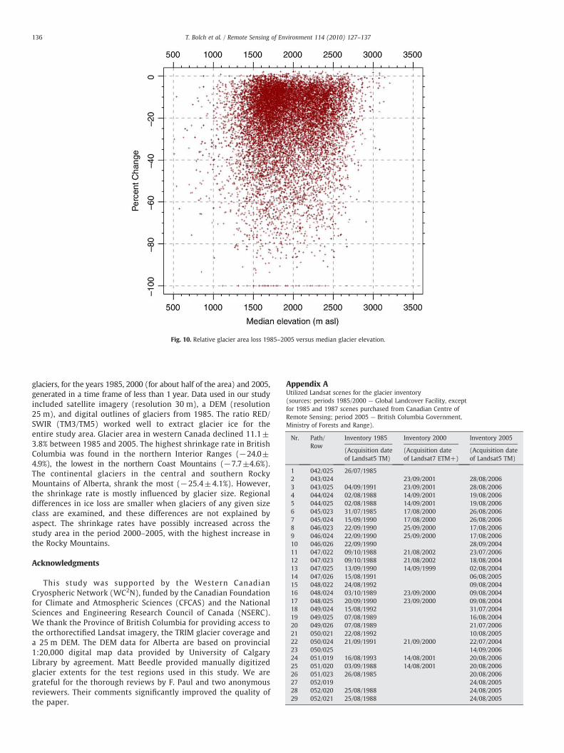
Fig. 10. Relative glacier area loss 1985–2005 versus median glacier elevation.
(Acquisition dateof Landsat5 TM)
(Acquisition dateof Landsat7 ETM+)
(Acquisition dateof Landsat5 TM)
1 042/025 26/07/19852 043/024 23/09/2001 28/08/20063 043/025 04/09/1991 23/09/2001 28/08/20064 044/024 02/08/1988 14/09/2001 19/08/20065 044/025 02/08/1988 14/09/2001 19/08/20066 045/023 31/07/1985 17/08/2000 26/08/20067 045/024 15/09/1990 17/08/2000 26/08/20068 046/023 22/09/1990 25/09/2000 17/08/20069 046/024 22/09/1990 25/09/2000 17/08/200610 046/026 22/09/1990 28/09/200411 047/022 09/10/1988 21/08/2002 23/07/200612 047/023 09/10/1988 21/08/2002 18/08/200413 047/025 13/09/1990 14/09/1999 02/08/200414 047/026 15/08/1991 06/08/200515 048/022 24/08/1992 09/08/200416 048/024 03/10/1989 23/09/2000 09/08/200417 048/025 20/09/1990 23/09/2000 09/08/200418 049/024 15/08/1992 31/07/200419 049/025 07/08/1989 16/08/200420 049/026 07/08/1989 21/07/200621 050/021 22/08/1992 10/08/200522 050/024 21/09/1991 21/09/2000 22/07/200423 050/025 14/09/200624 051/019 16/08/1993 14/08/2001 20/08/200625 051/020 03/09/1988 14/08/2001 20/08/200626 051/023 26/08/1985 20/08/200627 052/019 24/08/200528 052/020 25/08/1988 24/08/200529 052/021 25/08/1988 24/08/2005
136 T. Bolch et al. / Remote Sensing of Environment 114 (2010) 127–137
glaciers, for the years 1985, 2000 (for about half of the area) and 2005,generated in a time frame of less than 1 year. Data used in our studyincluded satellite imagery (resolution 30 m), a DEM (resolution25 m), and digital outlines of glaciers from 1985. The ratio RED/SWIR (TM3/TM5) worked well to extract glacier ice for theentire study area. Glacier area in western Canada declined 11.1±3.8% between 1985 and 2005. The highest shrinkage rate in BritishColumbia was found in the northern Interior Ranges (−24.0±4.9%), the lowest in the northern Coast Mountains (−7.7±4.6%).The continental glaciers in the central and southern RockyMountains of Alberta, shrank the most (−25.4±4.1%). However,the shrinkage rate is mostly influenced by glacier size. Regionaldifferences in ice loss are smaller when glaciers of any given sizeclass are examined, and these differences are not explained byaspect. The shrinkage rates have possibly increased across thestudy area in the period 2000–2005, with the highest increase inthe Rocky Mountains.
Acknowledgments
This study was supported by the Western CanadianCryospheric Network (WC2N), funded by the Canadian Foundationfor Climate and Atmospheric Sciences (CFCAS) and the NationalSciences and Engineering Research Council of Canada (NSERC).We thank the Province of British Columbia for providing access tothe orthorectified Landsat imagery, the TRIM glacier coverage anda 25 m DEM. The DEM data for Alberta are based on provincial1:20,000 digital map data provided by University of CalgaryLibrary by agreement. Matt Beedle provided manually digitizedglacier extents for the test regions used in this study. We aregrateful for the thorough reviews by F. Paul and two anonymousreviewers. Their comments significantly improved the quality ofthe paper.
Appendix AUtilized Landsat scenes for the glacier inventory(sources: periods 1985/2000 — Global Landcover Facility, exceptfor 1985 and 1987 scenes purchased from Canadian Centre ofRemote Sensing; period 2005 — British Columbia Government,Ministry of Forests and Range).
Nr. Path/Row
Inventory 1985 Inventory 2000 Inventory 2005

(continued)
Nr. Path/Row
Inventory 1985 Inventory 2000 Inventory 2005
(Acquisition dateof Landsat5 TM)
(Acquisition dateof Landsat7 ETM+)
(Acquisition dateof Landsat5 TM)
30 052/022 25/08/1988 24/08/200531 052/023 08/09/1987 24/08/200532 053/019 15/08/200533 053/020 27/07/200434 053/021 27/07/200435 053/022 27/08/1986 27/07/200436 054/021 26/08/1989 13/09/200737 055/019 13/08/200538 055/020 08/09/1986 13/08/200539 055/020 01/08/1999 10/08/200440 056/020 11/09/200741 057/019 03/08/1999 29/07/200642 059/018 09/08/200543 059/019 09/08/200544 061/018 08/08/2005
Appendix A (continued)
137T. Bolch et al. / Remote Sensing of Environment 114 (2010) 127–137
References
Andreassen, L. M., Paul, F., Kääb, A., & Hausberg, J. E. (2008). The new Landsat-derivedglacier inventory for Jotunheimen, Norway, and deduced glacier changes since the1930s. The Cryosphere, 2(2), 131−145.
Aniya, M., Sato, H., Naruse, R., Skvarca, P., & Casassa, G. (1996). The use of satellite andairborne imagery to inventory outlet glaciers of the Southern Patagonian Icefield,South America. Photogrammetric Engineering and Remote Sensing, 62, 1361−1369.
Arendt, A. A., Echelmeyer, K. A., Harrison, W. D., Lingle, C. S., & Valentine, V. B. (2002).Rapid wastage of Alaska glaciers and their contribution to rising sea level. Science,297(5580), 382−386.
Barnett, T., Adam, J. C., & Lettenmaier, D. (2005). Potential impacts of a warming climateon water availability in snow-dominated regions. Nature, 438, 303−309.
Barry, R.G. (2008). Mountain Weather and Climate (pp. 512), 3rd ed. Cambridge UniversityPress.
Barry, R. G. (2006). The status of research on glaciers and global glacier recession: Areview. Progress in Physical Geography, 30(3), 285−306.
Bishop, M. P., Bonk, R., Kamp, U., & Shroder, J. F. (2001). Terrain analysis and datamodeling for alpine glacier mapping. Polar Geography, 25, 182−201.
Bolch, T. (2007). Climate change and glacier retreat in northern Tien Shan (Kazakhstan/Kyrgyzstan) using remote sensing data. Global and Planetary Change, 56, 1−12.
Bolch, T., Buchroithner, M. F., Kunert, A., & Kamp, U. (2007). Automated delineation ofdebris-covered glaciers based on ASTER data. In M. A. Gomarasca (Ed.), Proc. 27thEARSeL-Symposium, 4.-7.6.07, Bozen, Italy. GeoInformation in Europe. (pp. 403−410)Netherlands: Millpress.
Bolch, T., Buchroithner, M. F., Pieczonka, T., & Kunert, A. (2008). Planimetric andvolumetric Glacier changes in Khumbu Himalaya since 1962 using Corona, LandsatTM and ASTER data. Journal of Glaciology, 54(187), 592−600.
Bolch, T., & Kamp, U. (2006). Glacier mapping in high mountains using DEMs, Landsatand ASTER data. Proc. 8th Int. Symp. on High Mountain Remote Sensing Cartography,20–27 March 2005, La Paz, BoliviaGrazer Schriften der Geographie und Raum-forschung, vol. 41 (13−24).
Bolch, T, Menounos, B., & Wheate, R. (2008). GLIMS glacier database, Boulder, CO.National Snow and Ice Data Center/World Data Center for Glaciology. Digital Media.
British Columbia Ministry of Environment, Land and Parks (1992). British Columbiaspecifications and guidelines for geomatics, release 2.0, Victoria, B. C., Canada.
DeBeer, C., & Sharp, M. (2007). Recent changes in glacier area and volume within thesouthern Canadian Cordillera. Annals of Glaciology, 46, 215−221.
DeBeer, C., & Sharp, M. (2009). Topographic influences on recent changes of very smallglaciers in the Monashee Mountains, British Columbia, Canada. Journal ofGlaciology, 55(192), 691−700.
Demuth, M. N., Pinard, V., Pietroniro, A., Luckman, B. H., Hopkinson, C., Dornes, P., et al.(2008). Recent and past-century variations in the glacier resources of the CanadianRocky Mountains — Nelson River System. Terra Glacialis, 11(248), 27−52.
Falconer, G., Henoch, W. E. S., & Østrem, G. (1966). A glacier map of southern BritishColumbia and Alberta. Geographical Bulletin, 8(1), 108−112.
Granshaw, F.D., & Fountain, A. G. (2006). Glacier change (1958–1998) in theNorthCascadesNational Park Complex, Washington, USA. Journal of Glaciology, 52(177), 251−256.
Gratton, D. J., Howarth, P. J., & Marceau, D. J. (1990). Combining DEM parameters withLandsat MSS and TM imagery in a GIS for mountain glacier characterization. IEEETransactions on Geoscience and Remote Sensing, 28, 766−769.
Haeberli, W., Bösch, H., Scherler, K., Østrem, G., & Wallén, C. C. (Eds.). (1989). Worldglacier inventory — status 1988. Nairobi: IAHS(ICSI)/UNEP/UNESCO.
Hall, D. K., Riggs, G. A., & Salomonson, V. V. (1995). Development of methods formapping global snow cover using Moderate Resolution Imaging Spectroradiometer(MODIS) data. Remote Sensing of Environment, 54, 127−140.
Hayakawa, Y. S., Oguchi, T., & Lin, Z. (2008). Comparison of new and existing globaldigital elevation models, ASTER G-DEM and SRTM-3. Geophysical Research Letters,35, L17404, doi:10.1029/2008GL035036.
Huggel, C., Kääb, A., Haeberli, W., Teysseire, P., & Paul, F. (2002). Remote sensing basedassessment of hazards from glacier lake outbursts, a case study in the Swiss Alps.Canadian Geotechnical Journal, 39, 316−330.
Larsen, C. F., Motyka, R. J., Arendt, A. A., Echelmeyer, K. A., & Geissler, P. E. (2007). Glacierchanges in southeast Alaska and northwest British Columbia and contribution to sealevel rise. Journal of Geophysical Research, 112, F01007, doi:10.1029/2006JF000586.
Letréguilly, A. (1988). Relation between the mass balance of western Canadianmountain glaciers and meteorological data. Journal of Glaciology, 34(116), 11−18.
Luckman, B. H., Harding, K. A., & Hamilton, J. P. (1987). Recent glacier advances in thePremier Range, British Columbia. Canadian Journal of Earth Sciences, 24(6), 1149−1161.
Luckman, B. H., & Kavanagh, T. (2000). Impact of climate fluctuations on mountainenvironments in the Canadian Rockies. Ambio, 29(7), 371−380.
Manley, W. F. (2008). Geospatial inventory and analysis of glaciers: A case study for theeastern Alaska Range. In R. S. Williams & J.G. Ferrigno (Eds.), Satellite image atlas ofglaciers of the world. USGS Professional Paper 1386-K.
Moore, R. D., Fleming, S., Menounos, B., Wheate, R., Fountain, A., Holm, C., et al.(2009). Glacier change in Western North America: Influences on hydrology,geomorphic hazards, and water quality. Hydrologic Processes, 23, 42−61.
Ommanney, C. S. L. (1971). The Canadian glacier inventory. Glaciers, Proceedings ofWorkshop Seminar 1970, 24–25 September 1970, Vancouver, B.C. Ottawa, Ont., CanadianNational Committee for the International Hydrological Decade (pp. 23−30).
Ommanney, C. S. L. (1980). The inventory of Canadian glaciers: procedures, techniques,progress and applications. IAHS Publication, 126, 35−44.
Ommanney, C. S. L. (2002). Glaciers of the Canadian Rockies. In R. S. Williams, & J. G.Ferrigno (Eds.), Satellite Image Atlas of the Glaciers of the World — North America(pp. J199−J289). U.S. Geological Survey Professional Paper 1386-J-1.
Ommanney, C. S. L. (2002). Mapping Canada's glaciers. In R. S. Williams, & J. G. Ferrigno(Eds.), Satellite image atlas of glaciers of the world — North America (pp. J83−J110).U.S. Geological Survey Professional Paper 1386-J-1.
Paul, F., & Andreassen, A. (2009). A new glacier inventory for the Svartisen region,Norway, from Landsat ETM+data: challenges and change assessment. Journal ofGlaciology, 55(192), 607−618.
Paul, F., Huggel, C., & Kääb, A. (2004). Combining satellite multispectral image data anda digital elevation model for mapping of debris-covered glaciers. Remote Sensing ofEnvironment, 89(4), 510−518.
Paul, F., Huggel, C., Kääb, A., & Kellenberger, T. (2003). Comparison of TM-derivedglacier areas with higher resolution data sets. EARSeL eProceedings 2 (Observing ourcryosphere from space) (pp. 15–21).
Paul, F., & Kääb, A. (2005). Perspectives on the production of a glacier inventory frommultispectral satellite data in Arctic Canada: Cumberland Peninsula, Baffin Island.Annals of Glaciology, 42, 59−66.
Paul, F., Kääb,A., Maisch,M., Kellenberger, T.,& Haeberli,W. (2002).Thenewremotesensingderived Swiss Glacier Inventory: I.Methods. Annals of Glaciology, 34, 355−361.
Paul, F., Kääb, A., Maisch, M., Kellenberger, T., & Haeberli, W. (2004). Rapiddisintegration of Alpine glaciers observed with satellite data. Geophysical ResearchLetters, 31(21), L21402, doi:10.1029/2004GL020816.
Racoviteanu, A. E., Arnaud, Y., Williams, M. W., & Ordonez, J. (2008). Decadal changesin glacier parameters in the Cordillera Blanca, Peru, derived from remote sensing.Journal of Glaciology, 54(186), 499−510.
Ranzi, R., Grossi, G., Iacovelli, L., & Taschner, T. (2004). Use ofmultispectral ASTER imagesfor mapping debris-covered glaciers within the GLIMS Project. Use of multispectralASTER images for mapping debris-covered glaciers within the GLIMS ProjectIEEEInternational Geoscience and Remote Sensing Symposium, Vol. II (pp. 1144−1147).
Raup, B., & Khalsa, S. J. S. (2007).GLIMS Analysis Tutorial, vers. 22/05/2007 (pp. 15). Boulder:NSIDC http://glims.org/MapsAndDocs/assets/GLIMS_Analysis_Tutorial_a4.pdf
Rott, H. (1994). Thematic studies in alpine areas by means of polarimetric SAR andoptical imagery. Advances in Space Research, 14, 217−226.
Schiefer, E., Menounos, B., & Wheate, R. (2007). Recent volume loss of British Columbiaglaciers, Canada. Geophysical Research Letters, 34, L16503, doi:10.1029/2007GL030780.
Schiefer, E., Menounos, B., & Wheate, R. (2008). An inventory andmorphometric analysisof British Columbia glaciers, Canada. Journal of Glaciology, 54(186), 551−560.
Schmidt, J., & Dikau, R. (1999). Extracting geomorphometric attributes and objects fromdigital elevation models— semantics, methods, future needs. In R. Dikau & H. Saurer(Eds.), GIS for Earth Surface Systems: Analysis and Modeling of the Natural Environment(pp. 153−173). Gebrüder Borntraeger Verlag, Berlin.
Shea, J., Marshall, S., & Livingston, J. (2004). Glacier distributions and climate in theCanadian Rockies. Arctic, Antarctic, and Alpine Research, 36(2), 272−279.
Sidjak, R. W., & Wheate, R. D. (1999). Glacier mapping of the Illecillewaet Icefield,British Columbia, Canada, using Landsat TM and digital elevation data. InternationalJournal of Remote Sensing, 20, 273−284.
Stahl, K., & Moore, R. D. (2006). Influence of watershed glacier coverage on summerstreamflow in British Columbia, Canada. Water Resources Research, 42, W06201.
Stanley, A. D. (1970). Inventory of the glaciers in theWaputikMountains. A pilot study foran inventory of the glaciers in the Rocky Mountains. Perennial ice and snow masses: aguide for compilation and assemblage of data for a world inventory (Technical Papers inHydrology) (pp. 36−46). Paris: UNESCO/IAHS.
Tucker, C., Grant, D., & Dykstra, J. (2004). NASA's global orthorectified Landsat data set.Photogrammetric Engineering & Remote Sensing, 70(3), 313−322.
VanLooy, J. A., & Forster, R. R. (2008). Glacial changes of five southwest British Columbiaicefields. Journal of Glaciology, 54(186), 469−478.
WGMS (2007). Glacier Mass Balance Bulletin No. 9 (2004–2005), Haeberli, W., Hoelzle,M. & Zemp, M. (Eds.) ICSU-IUGG-UNEP-UNESO-WMO.
WGMS/UNEP (2008). In M. Zemp, I. Roer, A. Kääb, M. Hoelzle, & W. Haeberli (Eds.),Global Glacier Changes: facts and figures( pp. 88).
Williams, R. S., & Ferrigno, J. G. (Eds.). (2002). Satellite image atlas of glaciers of theworld—North America: US Geological Survey Professional Paper 1386-J.