Landowner Communication and Consultation Plan€¦ · The objectives of the Landowner Communication...
62
Landowner Communication and Consultation Plan P-5169 Mandalong Mine June 2012
Transcript of Landowner Communication and Consultation Plan€¦ · The objectives of the Landowner Communication...
Landowner Communication and
Consultation Plan
P-5169
Mandalong Mine
June 2012
Landowner Consultation and Communication Plan
Mandalong Mine Environmental Management System
Revision 6 Authorised by: Mine Manager
Document ID: P-5169 i
Table of Contents
1.0 INTRODUCTION ....................................................................................................................................... 1
2.0 PURPOSE ................................................................................................................................................. 1
3.0 OBJECTIVES OF THE LANDOWNER CONSULTATION AND COMMUNICATION PLAN ................................. 1
4.0 CONSULTATION....................................................................................................................................... 2
4.1 CONSULTATION PRINCIPLES ............................................................................................................................. 2
4.2 CONSULTATION EVALUATION AND FEEDBACK ...................................................................................................... 3
5.0 MINE OPERATIONS ................................................................................................................................. 3
6.0 DESCRIPTION OF OPERATIONS AND LANDOWNER INTERACTION ........................................................... 7
6.1 LANDOWNER CONCERNS AND INTERACTIONS ...................................................................................................... 7
6.2 PROPERTY SUBSIDENCE MANAGEMENT PLANS .................................................................................................... 7
6.3 DEVELOPMENT OF PROPERTY SUBSIDENCE MANAGEMENT PLANS ........................................................................... 8
6.3.1 PSMP Phase 1 .................................................................................................................................. 8
6.3.2 PSMP Phase 2 .................................................................................................................................. 8
6.3.3 PSMP Phase 3 .................................................................................................................................. 9
6.3.4 PSMP Phase 4 .................................................................................................................................. 9
6.4 PREPARATION OF PROPERTY SUBSIDENCE MANAGEMENT PLANS ............................................................................ 9
6.5 PSMP – MITIGATION WORKS ....................................................................................................................... 10
7.0 SUBSIDENCE MANAGEMENT PLANS ...................................................................................................... 11
7.1 SMP - PREPARATION ................................................................................................................................... 11
7.2 SMP - INCORPORATION OF DETAILS FROM PSMP ............................................................................................. 11
8.0 EXPLORATION DRILLING PROGRAMMES ............................................................................................... 12
8.1 EXPLORATION DRILLING COMMUNICATION AND CONSULTATION ........................................................................... 12
9.0 OTHER CONSENT CONDITIONS FOR LANDOWNER COMMUNICATION AND CONSULTATION ................ 15
9.1 INITIAL VALUATION AND OPTIONS AGREEMENT ................................................................................................. 15
9.2 VALUATION AND OPTIONS AGREEMENT – NOISE, VIBRATION OR DUST .................................................................. 15
9.3 PROPERTY ACQUISITION AND COMPENSATION - SUBSIDENCE EFFECTS ................................................................... 15
9.4 FOLLOW UP STRUCTURAL INSPECTION .............................................................................................................. 16
9.5 ACQUISITION AND COMPENSATION - DISPUTES .................................................................................................. 16
9.6 ACQUISITION AND COMPENSATION - PROCEDURE AND TIMING OF ACQUISITION ...................................................... 16
9.7 NEGOTIATIONS OUTSIDE THE CONSENT CONDITIONS .......................................................................................... 17
9.8 NOISE, VIBRATION OR DUST .......................................................................................................................... 17
9.8.1 Exceedance of Criteria - Noise, Vibration or Dust .......................................................................... 17
Landowner Consultation and Communication Plan
Mandalong Mine Environmental Management System
Revision 6 Authorised by: Mine Manager
Document ID: P-5169 ii
9.8.2 Independent Monitoring – Noise, Vibration or Dust ..................................................................... 17
9.8.3 Property Acquisition and Compensation – Noise, Vibration or Dust ............................................. 18
9.9 WETLANDS MANAGEMENT PLAN .................................................................................................................... 18
9.10 COMMUNITY COMPLAINTS ....................................................................................................................... 19
9.11 COMMUNITY INFORMATION ...................................................................................................................... 19
10.0 REVIEW AND RESPONSIBILITY .......................................................................................................... 20
10.1 REVIEW OF PROPERTY SUBSIDENCE MANAGEMENT PLAN PROCESS .................................................................. 20
10.2 COMPLIANCE ......................................................................................................................................... 20
10.3 MANAGEMENT RESPONSIBILITY ................................................................................................................. 20
List of Figures
FIGURE 1 - EXPLORATION LICENCES ........................................................................................................... 6
FIGURE 2 - EXPLORATION DRILLING CONSULTATION FLOW CHART ................................................................ 13
List of Tables
TABLE 1 - LANDOWNER AND COMMUNITY CONSULTATION STRATEGY .............................................................. 2
TABLE 2 - TYPICAL LANDOWNER CONSULTATION FOR DRILLING EXPLORATION ................................................. 14
Appendices
APPENDIX 1 –SUBSIDENCE MANAGEMENT PLANS
APPENDIX 2 – CONDITIONS 15 TO 17 PROPERTY SUBSIDENCE MANAGEMENT PLANS
APPENDIX 3 – OTHER CONDITIONS RELATING TO COMMUNICATION AND CONSULTATION
APPENDIX 4 – ACCESS COMPENSATION AGREEMENTS
APPENDIX 5 – MANDALONG SOUTHERN EXTENSION STAKEHOLDER ENGAGEMENT PLAN
Landowner Consultation and Communication Plan
Mandalong Mine Environmental Management System
Revision 6 Authorised by: Mine Manager
Document ID: P-5169 iii
Document Control Details
DOCUMENT
DETAILS
Name: LANDOWNER COMMUNICATION AND CONSULTATION PLAN
Author: Mandalong Mine
Reference: P-5169
Revision No.: 6
Document Status Final
APPROVAL
DETAILS
Revision No.
Date Sent
Details of Approval Approved By Approval Date
Draft 26/09/01 Director General - DUAP
1 22/01/02 Dept of Planning S Haddad 31/01/02
2 2005 Internal review
3 August 2009
Internal review – removed consent requirements LSMP and notifications not required under modified consent 21st July 09.
4 Aug 2010
Internal review – included consultation, exploration and access agreement compensation schedule
5 June 2011
Revision – incorporating MCA comments (June 2011)
6 June 2012
Internal review – including update for Consent Modification October 2011
CIRCULATION
DETAILS
Name Department Circulation Date (approved doc.)
No of Copies
Mandalong Mine Files
11/02/02 2
Mandalong Mine Office
11/02/02 2
Milton Morris MMCCC 11/02/02 6
Geoff Noonan DUAP 07/03/02 1
Milton Morris MMCCC 03/09/09 1
Milton Morris MMCCC 11/10/10 1
Michael Lloyd TIRIS NSW 11/10/10 1
Milton Morris MMCCC 12/06/12 1
Landowner Consultation and Communication Plan
Mandalong Mine Environmental Management System
Revision 6 Authorised by: Mine Manager
Document ID: P-5169 iv
ABBREVIATIONS AEMR Annual Environmental Management Report
CHP Coal Handling Plant
DOP Department of Planning & Infrastructure (formerly, DIPNR, DLWC and PNSW)
OEH Office of Environment and Heritage
EIS Environmental Impact Statement
EA Environmental Assessment
EPL Environmental Protection Licence
EL Exploration Licence
GHG Greenhouse Gas
DRE
Division of Resources and Energy - NSW Department Trade and Investment, Regional Infrastructure and Services (formerly Industry and Investment)
LMCC Lake Macquarie City Council
MMCCC Mandalong Mine Community Consultative Committee
MSB Mine Subsidence Board
Mtpa Million Tonne Per Annum
MOP Mining Operations Plan
PSMP Private Property Subsidence Management Plan
SMP Subsidence Management Plan
Landowner Consultation and Communication Plan
Mandalong Mine Environmental Management System
Revision 6 Authorised by: Mine Manager
Document ID: P-5169 v
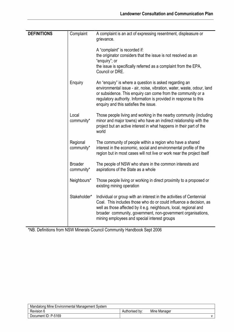
DEFINITIONS Complaint A complaint is an act of expressing resentment, displeasure or grievance. A “complaint” is recorded if: the originator considers that the issue is not resolved as an “enquiry”; or the issue is specifically referred as a complaint from the EPA, Council or DRE.
Enquiry An “enquiry” is where a question is asked regarding an environmental issue - air, noise, vibration, water, waste, odour, land or subsidence. This enquiry can come from the community or a regulatory authority. Information is provided in response to this enquiry and this satisfies the issue.
Local community*
Those people living and working in the nearby community (including minor and major towns) who have an indirect relationship with the project but an active interest in what happens in their part of the world
Regional community*
The community of people within a region who have a shared interest in the economic, social and environmental profile of the region but in most cases will not live or work near the project itself
Broader community*
The people of NSW who share in the common interests and aspirations of the State as a whole
Neighbours* Those people living or working in direct proximity to a proposed or existing mining operation
Stakeholder* Individual or group with an interest in the activities of Centennial Coal. This includes those who do or could influence a decision, as well as those affected by it e.g. neighbours, local, regional and broader community, government, non-government organisations, mining employees and special interest groups
*NB. Definitions from NSW Minerals Council Community Handbook Sept 2006
Landowner Consultation and Communication Plan
Mandalong Mine Environmental Management System
Revision 6 Authorised by: Mine Manager
Document ID: P-5169 1
1.0 Introduction
This plan will focus on the consultation required in relation to the Mine’s operations with potential to impact
on landowners in the Development Approval (DA 97/800) area and will also include references to various
other consultation relating to operations and the Consent Conditions.
2.0 Purpose
The purpose of the Plan is to provide a consistent management framework to identify, inform, consult and
involve landowners with an interest in the activities associated with the Mandalong Mine.
3.0 Objectives of the Landowner Consultation and Communication Plan
The objectives of the Landowner Communication and Consultation Plan are to:
initiate and to maintain communication and consultation with landowners about the Mine’s
operation and its activities including exploration, subsidence and surface facilities;
provide landowners with all available information to allow them to participate in the
development of PSMPs and to reach informed decisions;
make landowners aware of all the choices that may be available to them under the Consent
Conditions;
identify and respond to all landowner issues in relation to the operation of the Mine;
meet the requirements of the Development Consent; and
monitor, report and make public the effectiveness of this Plan.
This Landowner Communication and Consultation Plan (LCCP) outlines the management of and
mechanisms for communication and consultation with landowners in line with the Consent Conditions.
Landowner Consultation and Communication Plan
Mandalong Mine Environmental Management System
Revision 6 Authorised by: Mine Manager
Document ID: P-5169 2
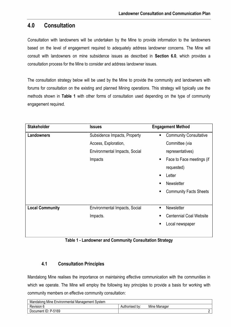
4.0 Consultation
Consultation with landowners will be undertaken by the Mine to provide information to the landowners
based on the level of engagement required to adequately address landowner concerns. The Mine will
consult with landowners on mine subsidence issues as described in Section 6.0, which provides a
consultation process for the Mine to consider and address landowner issues.
The consultation strategy below will be used by the Mine to provide the community and landowners with
forums for consultation on the existing and planned Mining operations. This strategy will typically use the
methods shown in Table 1 with other forms of consultation used depending on the type of community
engagement required.
Table 1 - Landowner and Community Consultation Strategy
4.1 Consultation Principles
Mandalong Mine realises the importance on maintaining effective communication with the communities in
which we operate. The Mine will employ the following key principles to provide a basis for working with
community members on effective community consultation:
Stakeholder Issues Engagement Method
Landowners Subsidence Impacts, Property
Access, Exploration,
Environmental Impacts, Social
Impacts
Community Consultative
Committee (via
representatives)
Face to Face meetings (if
requested)
Letter
Newsletter
Community Facts Sheets
Local Community Environmental Impacts, Social
Impacts.
Newsletter
Centennial Coal Website
Local newspaper
Landowner Consultation and Communication Plan
Mandalong Mine Environmental Management System
Revision 6 Authorised by: Mine Manager
Document ID: P-5169 3
1. INFORM – provide the identified stakeholders with available and balanced information to ensure
they understand the nature of the operations, any changes and the likely impacts.
2. CONSULT – consult with the identified stakeholders by providing mechanisms for two way
information flows between company and community.
3. INVOLVE – work directly with the identified landowners throughout the process to ensure issues
and concerns are understood and considered.
4.2 Consultation Evaluation and Feedback
To receive feedback on consultation from landowners the Mine has established and will operate a
community enquiries/complaints line (1800 730 919) to enable landowners to contact the Mine 24 hours a
day. The Mine will respond to any registered community enquiries received by this number as described in
the Mine’s work procedure “Dealing with Community Complaints and Request of Information” (WP-137).
Follow up contact on complaints will be made by the supervisor or Environmental & Community
Coordinator, when the investigation has been completed and no more than 24 hours after the complaint was
received. Follow up contact in response to enquiries will be made as soon as information is available to
respond and address the enquiry.
Feedback on landowner related matters can also be provided by using the email address
([email protected]) provided on the Centennial Coal, Operations and Community
web page. As discussed above, requests for information will be responded to by the Environment and
Community Coordinator, Mine Manger or their delegate.
5.0 Mine Operations
Mandalong Mine is owned and operated by Centennial Mandalong Pty Ltd (‘Centennial Mandalong’), a
subsidiary of Centennial Coal Company Limited (‘Centennial’) and is located near Morisset in the Newcastle
Coalfield of New South Wales. Centennial completed the purchase of Powercoal in August 2002.
Centennial was purchased by Banpu Public Company Limited (“Banpu”) in November 2010.
The Mine comprises of three main infrastructure areas, to support mining operations: -

Landowner Consultation and Communication Plan
Mandalong Mine Environmental Management System
Revision 6 Authorised by: Mine Manager
Document ID: P-5169 4
The Mandalong Mine, consisting of underground workings including a longwall panel,
development units, surface infrastructure including office and bathhouses, store and equipment
yards, mine fans and gas drainage plant located near Morisset;
The Cooranbong Services Site, consisting of underground workings and surface infrastructure
including Coal Handling Plant (CHP), coal stockpiles, support buildings and private coal
haulage road located near Dora Creek and;
The Delta Entry Site, which encompasses an entry and coal delivery system, near Wyee at the
Vales Point Rail Unloader Facility.
The Mandalong Mine was proposed by Powercoal Pty Ltd and an Environmental Impact Statement (“EIS”)
was submitted in 1997. The Mine was granted development approval (DA97/800) in October 1998 following
a Commission of Inquiry (CoI). Mining operations are described in the “Cooranbong Colliery Life Extension
Project” EIS (Umwelt 1997) and Mandalong Mine “Modification to Development Consent” Environmental
Assessment (EA) (Hansen Bailey 2008). Proposals for future infrastructure (i.e. mine shafts or surface
infrastructure) or modifications to operations, not described by these documents will require the Mine to
consult with the community before seeking approval as described in Section 4.0.
The Mine is situated approximately 130 km north of Sydney suppling coal to the domestic power and to
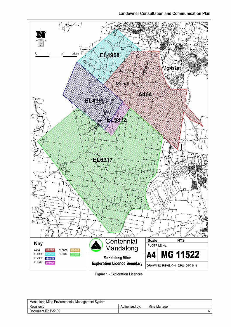
export markets via Newstan Colliery. The Mine as shown in Figure 1 is located within the proclaimed
Mandalong Subsidence District with the Mining Leases situated within Lake Macquarie local government
area (LGA) and an exploration licence partially within the Wyong LGA. In relation to neighbours of the
Mine’s operation, there are approximately 150 landowners with properties located within the current mining
lease areas (ML1543 and ML1443).
Centennial constructed the Mandalong Mine site and decline tunnel near Morisset to access the Mandalong
mining area. Coal extraction by longwall mining operations commenced in January 2005 and is expected to
produce 5.5 Million Tonne Per Annum (Mtpa). The Mine has approval to extract up to six million tonnes per
annum of coal from the West Wallarah Seam using the longwall mining method.
A modification to Mine’s development consent was obtained in 2005 to construct multiple enclosed flares
planned to be used to reduce fugitive methane GHG emissions from the Mine’s gas drainage plant. In July
2009 Mandalong Mine received approval from NSW DOP to construct and operate multiple methane gas
engines with a total generating capacity of up to 12 MW. Work continues on this project as Centennial plan
to reduce fugitive emissions at Mandalong from two methane sources - high concentration drainage gas and
Landowner Consultation and Communication Plan
Mandalong Mine Environmental Management System
Revision 6 Authorised by: Mine Manager
Document ID: P-5169 5
low concentration ventilation air methane (VAM). Both sources are currently vented to atmosphere and
various technologies are being assessed. Community members will be consulted on the planning approvals
required for and development of Greenhouse Gas abatement projects as described in Section 4.0.
Coal mining operations at Cooranbong Colliery within CCL 762 were completed in 2005 and as such the
majority of subsidence impacts have previously occurred and been remediated. Subsidence monitoring as
per NSW TIRIS requirements above the Cooranbong Colliery workings will continue to monitor potential
mine subsidence impacts. Consultation with landowners, at the Cooranbong Service Site and Delta Entry
Site will be in relation to the potential impacts from surface infrastructure including the operating Coal
Handling Plants (CHP’s) and coal loading facilities.
The Mine’s Exploration Licences (EL) entitle the Mine to conduct exploration, including drilling, located as
shown in Figure 1 within Exploration Licences (EL1543, 4969, 4968 &, A404) situated above the
Mandalong Mine mining area. Exploration for the Mandalong Southern Extension Project (“Project”) is
undertaken within EL6137 shown in Figure 1 and consultation is conducted in accordance with the existing
“Mandalong Southern Extension Project Exploration Stakeholder Engagement Plan” (Centennial Coal Pty
Ltd dated November 2009) contained in Appendix 5. The project is required to operate in accordance the
conditions in EL6137 and as such the consent conditions in DA97/800 are not applicable.
Centennial Coal (“Limited”) owns a number of properties in the Mandalong area, managed by the
Centennial Coal Property and Titles Manager. Landowners and community issues as identified in Section
4.2 relating to the management of Centennial Coal properties will be addressed by the Centennial Coal
Property Manager or delegate. Consent condition 42 (DA87/900) requires a Land Management Plan be
developed for rural properties acquired by Centennial Coal. These properties are considered “rural holdings”
as they have agricultural potential and are being used for this purpose. The Centennial Coal Property
Manager or delegate where required will consult with landowners on property related matters and provide
feedback on property management to the MMCCC.
Landowner Consultation and Communication Plan
Mandalong Mine Environmental Management System
Revision 6 Authorised by: Mine Manager
Document ID: P-5169 6
Figure 1 - Exploration Licences
Landowner Consultation and Communication Plan
Mandalong Mine Environmental Management System
Revision 6 Authorised by: Mine Manager
Document ID: P-5169 7
6.0 Description of Operations and Landowner Interaction
6.1 Landowner Concerns and Interactions
Landowners and community members have previously (EIS Umwelt 1998) described their concerns relating
to the operation of the Mine. A Social Impact Assessment was undertaken in 2001 by Coakes Consulting
interviewing landowners to identify their concerns about Mining. The Mine acknowledge landowner
concerns relating to subsidence impacts predicted in the EIS and acted to minimise these by revising the
Mine layout to narrow longwall panel design. These concerns and those described during consultation with
the MCA (June 2011) on the revised LCCP (Version 5) are:
Mining impacts on the environment and community;
Uncertainties relating to resident and landowner rights and predicted effects to property;
Uncertainties relating to predicted effects to property such as land subsidence, damage to property,
and flood levels;
Environmental issues such as subsidence, flooding and hydrological effects;
Property acquisition, management and devaluation of private properties;
Physical damage to roads and infrastructure from subsidence;
Mental health (stress/anxiety etc) issues relating, to landowners that the mine directly impact;
Inadequate consultation process leading to suspicion and fear; and
Social issues relating to company involvement in the community and effects on sense of
community.
6.2 Property Subsidence Management Plans
In line with Development Consent Conditions 15 through 17 (refer Appendix 2), the Company is required to
prepare Property Subsidence Management Plans (PSMP) for each property title if subsidence may cause
impacts on privately owned land and submit a Subsidence Management Plan (SMP) for longwall mining to
the satisfaction of Executive Director Mineral Resources within DRE.
The process with respect to PSMPs (refer to Appendix 1 for full details) will involve consultation with each
landowner as required by this plan.
Landowner Consultation and Communication Plan
Mandalong Mine Environmental Management System
Revision 6 Authorised by: Mine Manager
Document ID: P-5169 8
6.3 Development of Property Subsidence Management Plans
Landowner communication and consultation for the PSMP would take place in several phases as the PSMP
is developed. Preliminary communication and consultation to understand landowner issues in the
development of a PSMP would commence after written advice is provided to the landowner.
The written notification shall provide information including:
Plan of proposed longwall mining;
The expected maximum predicted subsidence values and potential impacts of longwall mining
below the landowners property based on the best available information;
An offer to pay any reasonable costs for the landowner to obtain legal or other advice on the
PSMP (refer Condition 17 in Appendix 2);
The timing for later phases of landowner consultation, including finalising any relevant PSMP;
Mine planning, SMP application and approval process;
The relevant conditions of consent;
Information on Landowner legal rights who receive a PSMP; and
SMP approvals process diagram.
6.3.1 PSMP Phase 1
Initial contact with the landowner will focus on the identification of issues to be addressed in the PSMP and
arranging access to collect background information (Consent Condition 15– see Appendix 1) to assist in
the production of a draft PSMP. Such information shall include on agreement from the landowner:
A detailed survey of the property.
Structural inspection of buildings.
Land use studies, including agricultural assessment were a business or enterprise is
conducted.
Flood hydrology study for prosperities in the 1 in 100 year flood plain area.
6.3.2 PSMP Phase 2
Each relevant landowner shall be given a draft PSMP for discussion. The draft PSMP (where possible) will
be presented to the Landowner in person by the appointed representative of Mandalong Mine. This will
allow any immediate concerns to be addressed and any further issues to be raised and discussed including:
Predicted impacts and consequences to any dwelling, improvement or land;
Proposed mitigation measures for the individual property; and
Landowner Consultation and Communication Plan
Mandalong Mine Environmental Management System
Revision 6 Authorised by: Mine Manager
Document ID: P-5169 9
Information identifying the landowner’s legal rights to acquisition and compensation in
accordance with the consent, Mining Act 1992 and Mine Subsidence Board Compensation Act
1961.
6.3.3 PSMP Phase 3
A revision of the PSMP as required based on the issues raised in Phase 2. The changes to the draft PSMP
shall be made and re-issued to the landowner.
6.3.4 PSMP Phase 4
The PSMP shall reflect the final position of the Landowner and Mandalong Mine in relation to the proposed
longwall mining or secondary extraction. The PSMP shall if required by the landowner contain a section
provided by landowner describing their any issues with the final PSMP document.
Please note that Phases 2 and 3 are part of an iterative process and may require more than one round of
consultation to fully consider all the issues.
The consultation process would be expected to last from 3 months up to 2 years and involve several
meetings depending on the level of effects of mining and the complexity of the issues to be resolved.
6.4 Preparation of Property Subsidence Management Plans
Consent Conditions 15, 16 and 17 (refer to Appendix 1) provide a detailed list of inclusions and the process
for the preparation of the PSMP.
In preparing a PSMP some of the key issues to be addressed by Centennial are:
Consult with landowners, taking their views into account, and include in consultation discussions on
integrating proposed mitigation works within the management of the property as a whole
Advise affected landowners of any potential impacts of the proposed mining and review and discuss
implementation procedures
Survey drainage channels within and adjacent to the relevant property
Assess in relation to agriculture, the relevant property’s utilisation, improvements and underlying
suitability
Ensure continuation of agricultural activities and where practicable, improve the opportunity for
sustained agriculture by using surface remedial works
Landowner Consultation and Communication Plan
Mandalong Mine Environmental Management System
Revision 6 Authorised by: Mine Manager
Document ID: P-5169 10
Review current utilisation of the land for business purposes, including value of improvements and
the business
Complete a structural inspection and report on all buildings with the consent of landowners and in
consultation with the MSB
Ensure all inspections, surveys and assessments referred to in Consent Condition 15,16 and 17 are
carried out at the expense of Centennial,
Provide a draft Property Subsidence Management Plan to the relevant landowner and convene an
on-site meeting to review this document, including MSB as required. Discuss identified subsidence
effects and applicable options for mitigation, compensation, acquisition, temporary relocation or
other agreements, as outlined in the Consent Conditions (See Appendix 1)
Provide a copy of the Property Subsidence Management Plan to the relevant landowner.
6.5 PSMP – Mitigation Works
PSMP’s will provide advice to landowners on any proposed mitigation measures and Centennial shall
consult with landowners and endeavour where possible to agree on the appropriate mitigation measures as
required under Consent Condition 17 (refer Appendix 1). The PSMP may also include mitigation measures
to improve natural features where impacts from subsidence are identified.
Access to a property for the purpose of implementing mitigation measures will be done in consultation with
the landowners through negotiating a Centennial “Access Agreement”, specifying conditions of entry, timing
of works and access compensation (refer Appendix 4). PSMP – Applicant to pay costs for legal and other
advice.
Consent Condition 17 (refer Appendix 2) requires Centennial to provide in writing, an offer to pay
reasonable costs for the landowner to obtain legal and other advice approved by the Company on the
PSMP, prior to or at the same time the PSMP is provided to the landowner. If other advice landowners may
write to the Company on the information being sought and the Company will consider the request prior to
commissioning any reports.
A standard up-front payment for legal and other advice is to be provided to all landowners that require a
PSMP as part of an SMP application. The standard payment will be provided with the initial SMP
notification. Appendix 4 – Access Compensation Schedule provides the current compensation rate for
PSMP legal or other advice.
Landowner Consultation and Communication Plan
Mandalong Mine Environmental Management System
Revision 6 Authorised by: Mine Manager
Document ID: P-5169 11
7.0 Subsidence Management Plans
7.1 SMP - Preparation
In accordance with Consent Condition 14 (refer Appendix 2), Centennial shall:
prepare a SMP for each longwall panel or group of longwall panels for which an application for
secondary workings approval is sought; and
ensure that the SMP is completed prior to approval from NSW TIRIS for secondary workings.
Each SMP shall be consistent with the conditions of the Development Consent, DRE, SMP guidelines, the
Environmental Management Strategy and relevant management plans.
7.2 SMP - Incorporation of Details from PSMP
A list will be provided in each SMP that indicates all the PSMPs that have been incorporated in the related
SMP.
Landowner Consultation and Communication Plan
Mandalong Mine Environmental Management System
Revision 6 Authorised by: Mine Manager
Document ID: P-5169 12
8.0 Exploration Drilling Programmes
Mandalong Mine proposes to undertake exploration drilling in Exploration Lease (EL4968, EL4969 EL5892,
and Authorisation 404) as shown in Figure 1, throughout mining operations to further define local geology to
improve the definition of the mining area and enhance the information used to predict subsidence on
property features. Exploration activities to be undertaken at Mandalong will consist of the works described in
the EL’s including “Category One” reconnaissance exploration works and “Category Two” exploration
activities requiring further approvals from NSW TIRIS. Exploration at Mandalong is conducted primarily by
vertical surface drilling, excavation and magnetometer survey.
A Review of Environmental Factors (REF) (GSS Environmental Pty Ltd December 2008) provides an area
based assessment of the environmental aspects in the Mandalong EL and uses a risk based approach to
select and manage exploration activities. The REF and internal exploration procedures will be used to
communicate and consult with landowners on the selection and establishment of exploration sites. Where
existing roads and tracks area available these will be used to access drill sites. Where these are not present
an excavator will be used to clear and establish access tracks and drill pads.
Typical exploration drill sites will involve minor surface clearing, conducted in accordance with the Mine’s
exploration drilling procedures, to allow for the establishment of equipment on site. Exploration drill sites will
generally consist of a 25 m by 25 m disturbance area with two sumps to recycle drilling fluids, associated
support equipment including air compressors, portable shed, toilet, drill rod truck and core handing storage
area.
8.1 Exploration Drilling Communication and Consultation
Landowners and local community will be provided information on exploration drilling programmes, prior to
commencing drilling activities through established consultation methods. The Mine’s Community
Consultative Committee (MMCCC) and community newsletter (Mandalong Mailbox) will provide information
in advance of drilling programmes to landowners within the local community and follow up consultation will
be available on request from landowners. A notice letter will be sent to landowners where there is a
potential exploration drill site, advising of drilling programme, access agreements and information on
exploration drilling.
Further face to face consultation with the landowner will occur to discuss the exploration site, obtain
landowner consent and negotiate an “Access Agreement”. Agreement will also be sought with neighbouring
Landowner Consultation and Communication Plan
Mandalong Mine Environmental Management System
Revision 6 Authorised by: Mine Manager
Document ID: P-5169 13
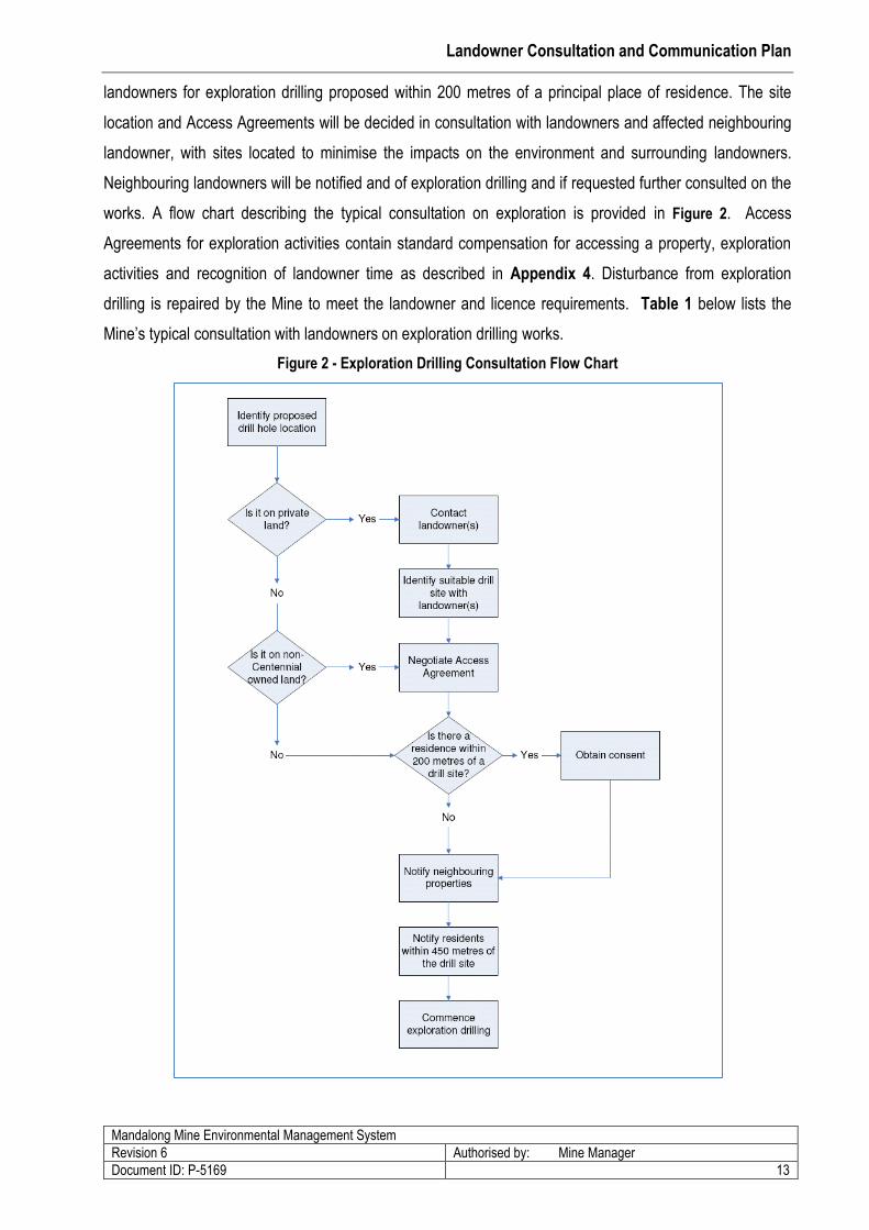
landowners for exploration drilling proposed within 200 metres of a principal place of residence. The site
location and Access Agreements will be decided in consultation with landowners and affected neighbouring
landowner, with sites located to minimise the impacts on the environment and surrounding landowners.
Neighbouring landowners will be notified and of exploration drilling and if requested further consulted on the
works. A flow chart describing the typical consultation on exploration is provided in Figure 2. Access
Agreements for exploration activities contain standard compensation for accessing a property, exploration
activities and recognition of landowner time as described in Appendix 4. Disturbance from exploration
drilling is repaired by the Mine to meet the landowner and licence requirements. Table 1 below lists the
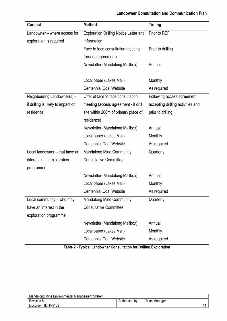
Mine’s typical consultation with landowners on exploration drilling works.
Figure 2 - Exploration Drilling Consultation Flow Chart
Landowner Consultation and Communication Plan
Mandalong Mine Environmental Management System
Revision 6 Authorised by: Mine Manager
Document ID: P-5169 14
Contact Method Timing
Landowner – where access for
exploration is required
Exploration Drilling Notice Letter and
Information
Face to face consultation meeting
(access agreement)
Newsletter (Mandalong Mailbox)
Local paper (Lakes Mail)
Centennial Coal Website
Prior to REF
Prior to drilling
Annual
Monthly
As required
Neighbouring Landowner(s) –
if drilling is likely to impact on
residence
Offer of face to face consultation
meeting (access agreement - if drill
site within 200m of primary place of
residence)
Newsletter (Mandalong Mailbox)
Local paper (Lakes Mail)
Centennial Coal Website
Following access agreement
accepting drilling activities and
prior to drilling
Annual
Monthly
As required
Local landowner – that have an
interest in the exploration
programme
Mandalong Mine Community
Consultative Committee
Newsletter (Mandalong Mailbox)
Local paper (Lakes Mail)
Centennial Coal Website
Quarterly
Annual
Monthly
As required
Local community – who may
have an interest in the
exploration programme
Mandalong Mine Community
Consultative Committee
Newsletter (Mandalong Mailbox)
Local paper (Lakes Mail)
Centennial Coal Website
Quarterly
Annual
Monthly
As required
Table 2 - Typical Landowner Consultation for Drilling Exploration
Landowner Consultation and Communication Plan
Mandalong Mine Environmental Management System
Revision 6 Authorised by: Mine Manager
Document ID: P-5169 15
9.0 Other Consent Conditions for Landowner Communication and
Consultation
The following Consent Conditions (as detailed in Appendix 3) contain references that may periodically
require communication, consultation and other dealings between some landowners and occupiers and
Centennial. The following section outlines the key elements of this process that are required to manage and
to record this communication, consultation and other dealings as required under various Consent Conditions
for Mandalong Mine.
9.1 Initial Valuation and Options Agreement
Consent Condition 25 (refer Appendix 3) availed landowners of the opportunity to request (in writing) a
valuation of their property from the Applicant, within six months of the date of consent. The initial period for
a valuation under this condition is now complete. Records have been kept at Mandalong Mine indicating
who requested a valuation and that the valuation was supplied to the relevant landowner. Records also
indicate that an offer was made to enter into an options agreement in accordance with Consent Condition
25(ii).
9.2 Valuation and Options Agreement – Noise, Vibration or Dust
The valuation and options agreement shall also be available to any landowner who may be affected by
noise, vibration or dust impacts from the Mandalong Mine Access Site or the Mandalong Services Site (refer
Consent Condition 26 – Appendix 3). The options agreement shall be based on an option to sell if and
when the landowner is entitled to acquisition under Consent Conditions 47, 48 or 56.
A record of the original request, monitoring results and any agreements or requests for acquisition will be
maintained at the Mine office on the property reference file.
9.3 Property Acquisition and Compensation - Subsidence Effects
The following Consent Conditions (as detailed in Appendix 3):
Consent Condition 27 (Significant Structural Damage to Dwelling)
Consent Condition 28 (Flood Hazard)
Consent Condition 29 (Land Use Impacts)
Landowner Consultation and Communication Plan
Mandalong Mine Environmental Management System
Revision 6 Authorised by: Mine Manager
Document ID: P-5169 16
Provide a range of outcomes for the landowner depending on the predicted subsidence effects outlined in
the notification from Centennial to the landowner and in the PSMPs.
Any request by a landowner to avail themselves of the options discussed above must be made to
Centennial in writing.
A copy of the written request will be held at the Mine office and the results of process recorded on the
property reference file.
9.4 Follow up Structural Inspection
If necessary to confirm the impact of significant structural damage to dwellings (Consent Condition 27) or
land use impact (Consent Condition 29), a landowner may request in writing for Centennial to conduct a
follow up structural inspection to the one carried out under Consent Condition 27 and 29.
9.5 Acquisition and Compensation - Disputes
Any disputes relating to land acquisition or compensation (except those relating to valuation matters) may
be referred by either party to the Independent Panel for consideration and advice if no agreement is
reached within 3 months of receipt by Centennial of the written request, or to the Mining Warden at any time
in accordance with the Mining Act (see Consent Condition 30).
A record of the written request, and resulting actions, will be kept at the Mine office in the Property
Reference Number File.
9.6 Acquisition and Compensation - Procedure and Timing of Acquisition
Consent Condition 31 and 32 set out the process for property acquisition once a written request by a
landowner under the Development Consent has been received by Centennial.
A copy of the written request will be held at the Mine office. Details of the process and resulting actions will
be recorded on the property reference file.

Landowner Consultation and Communication Plan
Mandalong Mine Environmental Management System
Revision 6 Authorised by: Mine Manager
Document ID: P-5169 17
9.7 Negotiations Outside the Consent Conditions
Notwithstanding any other conditions of the Development Consent the landowner and Centennial may enter
into various agreements that might relate for example to compensation or property acquisition (see Consent
Condition 33).
A copy of any agreements made under this section will be given to the relevant landowner and a further
copy held at the Mine office in the Property Reference Number File. A register of any agreements made
under this condition will be kept and a reference included in the appropriate PSMP.
9.8 Noise, Vibration or Dust
9.8.1 Exceedance of Criteria - Noise, Vibration or Dust
In the event that a landowner or occupier considers that noise, vibration or dust from the mine at their
dwelling is in excess of the relevant criteria, that person can notify Centennial in writing (refer Consent
Conditions 47 and 55). Centennial is then required to carry out a range of tasks that include:
Holding discussions with the landowner/resident affected;
Making arrangements for independent monitoring to determine the source and to quantify the
impact of the effect; and
Modify the mining activity that may be causing the impacts if adverse impacts are identified
Centennial will record any requests including the outcomes of any discussions, investigations and actions
on the property reference file.
9.8.2 Independent Monitoring – Noise, Vibration or Dust
In accordance with Consent Conditions 57, if a landowner or occupier considers that noise, vibration and/or
dust from the mine at their dwelling is in excess of the relevant criteria the landowner may make a written
request to the Director-General for an independent investigation. Where this investigation is required,
Centennial will:
implement an investigation to quantify the impact and determine the sources of the effect;
bear the cost of the independent investigation; and
make available relevant information to the independent person.
Landowner Consultation and Communication Plan
Mandalong Mine Environmental Management System
Revision 6 Authorised by: Mine Manager
Document ID: P-5169 18
The independent person will be approved and report back to the Director-General, OEH landowner or
occupier and Centennial (Consent Condition 59) on a quarterly basis.
9.8.3 Property Acquisition and Compensation – Noise, Vibration or Dust
If independent monitoring, in accordance with Consent Conditions 48 and 56, indicates that:
noise or vibration from the construction or operation of the Cooranbong Services Site or the Mine
Access Site; or
dust deposition from construction or mining operations
within a landowner’s property is in excess of the criteria set out in the Development Consent, the
landowner may request Centennial in writing to:
carry out works as agreed by the landowner to rectify the problem or
compensate the landowner for such effects
If appropriate control measures or compensation cannot be achieved the landowner may request
Centennial in writing to acquire the property.
9.9 Wetlands Management Plan
In accordance with Consent Condition 74, the Mine has prepared and implemented a Wetlands
Management Plan (WMP) to monitor wetlands likely to be subjected to impacts attributed to mining
operations. Consultation to undertake monitoring of these wetlands on landowners’ properties was
conducted in the preparation of this plan in February 2008. A general agreement to monitor at these sites
was reached with Landowners.
Landowners have been typically consulted up to two years in advance of mining on the requirement to
identify and monitor wetlands during landowner consultation for the development of Private Property
Subsidence Management Plans (PSMP’s). During the course of consulting with landowners an inventory of
natural features including wetlands from vegetation surveys is included in PSMP’s. Ongoing consultation
with private landowners on the requirements to monitor wetlands will be conducted during the development
of PSMP’s. If identified, the Mine will liaise with the landowner, requesting permission for access to monitor
wetlands in accordance with a formal land access agreement acceptable to the landowner (refer Appendix
4 – Access Compensation Schedule).
Landowner Consultation and Communication Plan
Mandalong Mine Environmental Management System
Revision 6 Authorised by: Mine Manager
Document ID: P-5169 19
9.10 Community Complaints
Consent Condition 98 requires Centennial to record details of complaints received. Mandalong Mine has a
Community Enquiries telephone line that can be called to lodge a complaint. The community enquiries
number 1800 730 919 is advertised at the Mine’s entry, in community newsletters to landowners, yellow
pages and in the local media (Lake’s Mail Newspaper). Complaints are lodged by calling the number and
providing details of the complaint to the Mine’s control room operator. Mine personnel will record the details
of complaints and inquiries and respond in accordance with the Mine’s procedure (WP-1371) “Dealing with
Community Complaints and Information Requests”.
The details of investigations, mitigatory action and follow-up liaison with the complainant will be maintained
in the Environment and Community Database (ECD). Centennial will make available a summary of
recorded complaints, excluding confidential landowner information, to the Community Consultative
Committee and relevant Government agencies. This summary will be provided in the Annual Environmental
Management Reports.
9.11 Community Information
Throughout the life of the Mine the following mechanisms will be used to keep the local community updated
with information about the project:
Mine Newsletters.
Community Information Sheets.
Open Days.
Website (Centennial Coal’s - Mandalong Mine Community Information page).
Community Consultative Committee meetings.
Landowner Consultation and Communication Plan
Mandalong Mine Environmental Management System
Revision 6 Authorised by: Mine Manager
Document ID: P-5169 20
10.0 REVIEW AND RESPONSIBILITY
10.1 Review of Property Subsidence Management Plan Process
In order to monitor the effectiveness of the process with respect to the Property Subsidence Management
Plans (PSMPs) in relation to both the operation and affected landowners, a review of the PSMP process will
occur after the completion of an individual longwall or group of longwalls. Such a review will involve
additional consultation with affected landowners to determine their level of satisfaction with all aspects of the
PSMP process. These aspects include:
preparation and implementation of PSMPs;
the consultation process during extraction of the longwall beneath their property; and
associated subsidence, mitigation and rehabilitation works.
The information provided and collected in this review will be recorded and, where appropriate, used to
update and improve the preparation and application of the PSMP. Over time, the intent would be to revise
the process to achieve the best solutions for both the landowner and the Company.
10.2 Compliance
To check compliance a regular review of the Plan will be carried out by the Environmental and Community
Coordinator in accordance with the Mine’s Business Management Framework.
All conditions of Consent and mining approvals are to be entered into and maintained in the Approvals
Compliance Database. The database provides a register of all approvals and conditions, with the ability to
assign and schedule the associated actions to ensure compliance.
10.3 Management Responsibility
The Manager of Mandalong Mine, or his delegate, will be responsible for providing resources and personnel
to implement this plan. The Mandalong Mine Approvals Coordinator will be responsible for consulting with
the community on PSMP’s and SMP related issues. The Mine’s Environment and Community Coordinator
will be responsible for all other actions required under this plan. External consultants may be utilised, at the
request of the Company where appropriate, to facilitate particular aspects of the Plan or to provide advice
on the provision of particular community involvement mechanisms.
Landowner Consultation and Communication Plan
Appendices - Selected Consent Conditions Relevant to Landowner
Communication and Consultation
i
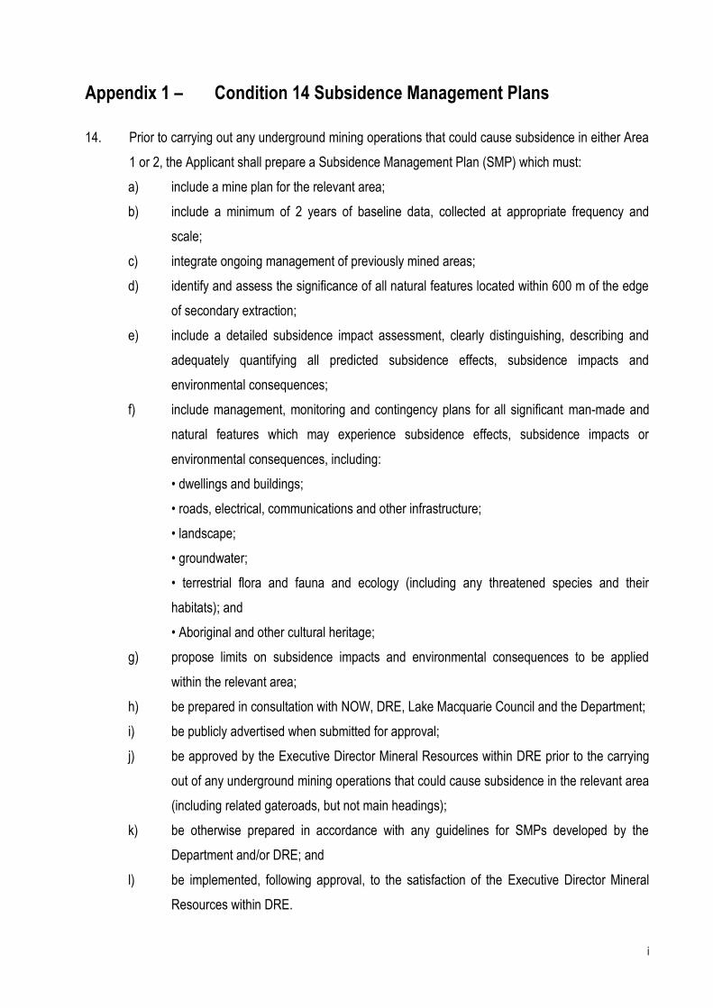
Appendix 1 – Condition 14 Subsidence Management Plans
14. Prior to carrying out any underground mining operations that could cause subsidence in either Area
1 or 2, the Applicant shall prepare a Subsidence Management Plan (SMP) which must:
a) include a mine plan for the relevant area;
b) include a minimum of 2 years of baseline data, collected at appropriate frequency and
scale;
c) integrate ongoing management of previously mined areas;
d) identify and assess the significance of all natural features located within 600 m of the edge
of secondary extraction;
e) include a detailed subsidence impact assessment, clearly distinguishing, describing and
adequately quantifying all predicted subsidence effects, subsidence impacts and
environmental consequences;
f) include management, monitoring and contingency plans for all significant man-made and
natural features which may experience subsidence effects, subsidence impacts or
environmental consequences, including:
• dwellings and buildings;
• roads, electrical, communications and other infrastructure;
• landscape;
• groundwater;
• terrestrial flora and fauna and ecology (including any threatened species and their
habitats); and
• Aboriginal and other cultural heritage;
g) propose limits on subsidence impacts and environmental consequences to be applied
within the relevant area;
h) be prepared in consultation with NOW, DRE, Lake Macquarie Council and the Department;
i) be publicly advertised when submitted for approval;
j) be approved by the Executive Director Mineral Resources within DRE prior to the carrying
out of any underground mining operations that could cause subsidence in the relevant area
(including related gateroads, but not main headings);
k) be otherwise prepared in accordance with any guidelines for SMPs developed by the
Department and/or DRE; and
l) be implemented, following approval, to the satisfaction of the Executive Director Mineral
Resources within DRE.

ii
Notes:
• The contingency plans required under paragraph (f) must address remediation (where appropriate) and be
based on a TARP structure.
• In reviewing an SMP, the Director-General may require changes in respect of subsidence impact limits,
subsidence management mechanisms or other matters.
• An SMP approved by DRE prior to 31 July 2009 is taken to satisfy the requirements of this condition.
• In respect of the first SMP prepared under this condition, the Executive Director Mineral Resources within
DRE may accept less than 2 years baseline data.
iii
Appendix 2 – Conditions 15 to 17 Property Subsidence Management
Plans
Property Subsidence Management Plans
15. If subsidence may cause impacts on privately-owned land, the Applicant shall prepare, and pay the
costs of, an individual Property Subsidence Management Plan (PSMP) for each affected land title
(or group of titles if agreed by the landowner). Each PSMP shall:
m) be provided to the landowner at least 7 days prior to the public advertisement of the SMP
as submitted;
n) be prepared in consultation with the landowner. This consultation shall include discussions
on integrating any proposed mitigation works with the management of the property as a
whole;
o) ensure that, with the consent of the landowner and in consultation with MSB, a structural
inspection is conducted for each structure on the land and a comprehensive structural
integrity report prepared (addressing all relevant components including roofs, ceilings,
openings, foundations, household sewage treatment and disposal systems, etc);
p) include a detailed subsidence impact assessment for the property clearly setting out all
predicted subsidence effects, subsidence impacts and environmental consequences
(based on best available geological and mine planning data);
q) include a survey of drainage channels within and adjacent to the land;
r) assess current agricultural utilisation, agricultural improvements and the underlying
agricultural suitability of the land;
s) assess current utilisation of the land for business purposes (other than
agriculture),including the value of business improvements and the business; and
t) indicate whether the landowner is entitled to acquisition of their land under conditions 27,
28 or 29.
iv
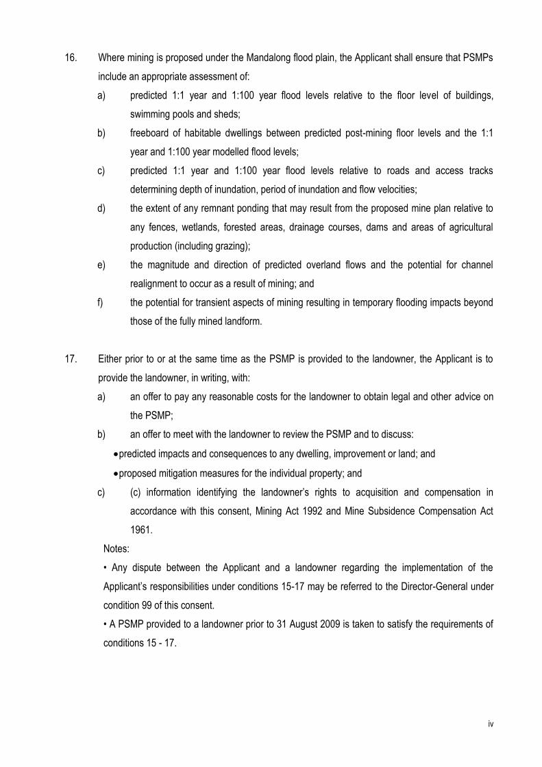
16. Where mining is proposed under the Mandalong flood plain, the Applicant shall ensure that PSMPs
include an appropriate assessment of:
a) predicted 1:1 year and 1:100 year flood levels relative to the floor level of buildings,
swimming pools and sheds;
b) freeboard of habitable dwellings between predicted post-mining floor levels and the 1:1
year and 1:100 year modelled flood levels;
c) predicted 1:1 year and 1:100 year flood levels relative to roads and access tracks
determining depth of inundation, period of inundation and flow velocities;
d) the extent of any remnant ponding that may result from the proposed mine plan relative to
any fences, wetlands, forested areas, drainage courses, dams and areas of agricultural
production (including grazing);
e) the magnitude and direction of predicted overland flows and the potential for channel
realignment to occur as a result of mining; and
f) the potential for transient aspects of mining resulting in temporary flooding impacts beyond
those of the fully mined landform.
17. Either prior to or at the same time as the PSMP is provided to the landowner, the Applicant is to
provide the landowner, in writing, with:
a) an offer to pay any reasonable costs for the landowner to obtain legal and other advice on
the PSMP;
b) an offer to meet with the landowner to review the PSMP and to discuss:
predicted impacts and consequences to any dwelling, improvement or land; and
proposed mitigation measures for the individual property; and
c) (c) information identifying the landowner’s rights to acquisition and compensation in
accordance with this consent, Mining Act 1992 and Mine Subsidence Compensation Act
1961.
Notes:
• Any dispute between the Applicant and a landowner regarding the implementation of the
Applicant’s responsibilities under conditions 15-17 may be referred to the Director-General under
condition 99 of this consent.
• A PSMP provided to a landowner prior to 31 August 2009 is taken to satisfy the requirements of
conditions 15 - 17.
v
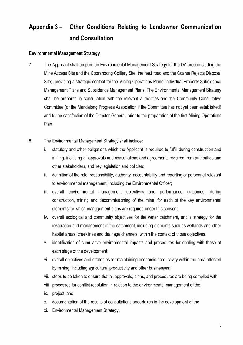
Appendix 3 – Other Conditions Relating to Landowner Communication
and Consultation
Environmental Management Strategy 7. The Applicant shall prepare an Environmental Management Strategy for the DA area (including the
Mine Access Site and the Cooranbong Colliery Site, the haul road and the Coarse Rejects Disposal
Site), providing a strategic context for the Mining Operations Plans, individual Property Subsidence
Management Plans and Subsidence Management Plans. The Environmental Management Strategy
shall be prepared in consultation with the relevant authorities and the Community Consultative
Committee (or the Mandalong Progress Association if the Committee has not yet been established)
and to the satisfaction of the Director-General, prior to the preparation of the first Mining Operations
Plan
8. The Environmental Management Strategy shall include:
i. statutory and other obligations which the Applicant is required to fulfill during construction and
mining, including all approvals and consultations and agreements required from authorities and
other stakeholders, and key legislation and policies;
ii. definition of the role, responsibility, authority, accountability and reporting of personnel relevant
to environmental management, including the Environmental Officer;
iii. overall environmental management objectives and performance outcomes, during
construction, mining and decommissioning of the mine, for each of the key environmental
elements for which management plans are required under this consent;
iv. overall ecological and community objectives for the water catchment, and a strategy for the
restoration and management of the catchment, including elements such as wetlands and other
habitat areas, creeklines and drainage channels, within the context of those objectives;
v. identification of cumulative environmental impacts and procedures for dealing with these at
each stage of the development;
vi. overall objectives and strategies for maintaining economic productivity within the area affected
by mining, including agricultural productivity and other businesses;
vii. steps to be taken to ensure that all approvals, plans, and procedures are being complied with;
viii. processes for conflict resolution in relation to the environmental management of the
ix. project; and
x. documentation of the results of consultations undertaken in the development of the
xi. Environmental Management Strategy.
vi
Initial Valuation and Options Agreement
25. Within six months of the date of this consent, any landowner within Area 1 may request in writing a
valuation of their property from the Applicant. Upon receipt of the request, the Applicant shall:
(i) obtain a valuation within one month of receipt of the request, which includes proper
consideration of a sum not less than the current market value of the owner’s interest in the
land, whosoever is the occupier, having regard to:
the existing use and permissible use of the land in accordance with the applicable planning
instruments at the date of the written request; and
the presence of improvements on the land and/or any Council approved building or
structure which although substantially commenced at the date of the request is completed
subsequent to that date,
as if the land was unaffected by the development proposal; and
(ii) within 14 days of receipt of the valuation, offer in writing to enter into an options agreement
with the landowner to acquire the land when notification in accordance with Condition 15 is
received, if the PSMP indicates the landowner is entitled to acquisition under conditions 27,
28 or 29.
26. The valuation and options agreement shall also be available to any landowner who may be affected
by noise and/or dust impacts from the Mine Access Site or the Mandalong Services. The options
agreement shall be based on an option to sell if and when the landowner is entitled to acquisition
under Conditions 47, 48 or 56.
Acquisition and Compensation – Significant Structural Damage to Dwellings
27. Where a dwelling within the DA area is, or is likely to be, subject to damage beyond the safe,
serviceable and repairable criteria as a result of the development, the landowner, after receiving the
PSMP from the Applicant in accordance with Condition 15, may request the Applicant in writing to:
(i) carry out such works as agreed by the landowner to remedy or mitigate any damage; or
(ii) compensate the landowner for such effects; or
(iii) acquire the whole of the property, or such part of the property requested by the landowner
where subdivision is approved.
vii
The Applicant shall comply with any such request for acquisition or compensation in accordance
with Conditions 30-37. If necessary to confirm the impact, the Applicant shall, at the request of the
landowner in writing, conduct a follow-up structural inspection to one carried out under Condition
15(c). Any inspection or assessment under this Condition shall be conducted as if it were
conducted under the relevant part of Condition 15.
Acquisition and Compensation – Flood Hazard
28. Where:
a dwelling has, or would have, a subsided floor level below the design predicted post
mining flood level as a result of the development, or
the flood hazard (as defined in Appendix B of the NSW Floodplain Management Manual) in
relation to a dwelling or access to the dwelling has been, or would be, increased as a result
of the development
the landowner, after receiving the PSMP from the Applicant in accordance with Condition 15, may
request the Applicant in writing to:
(i) carry out such works as agreed by the landowner to raise or relocate the dwelling and/or
provide suitable access to the property; or
(ii) acquire the whole of the property, or such part of the property requested by the landowner
where subdivision is approved.
The Applicant shall comply with any such request in accordance with Conditions 30-37.
Acquisition and Compensation - Land Use Impacts
29. Where a landowner suffers a loss of agricultural productivity or other adverse impact on the use of
land as a result of the development (including significant damage to structures other than dwellings
and/or flooding impacts not covered by Condition 28), the landowner, after receiving the PSMP from
the Applicant in accordance with Condition 15, may request the Applicant in writing to:
(i) carry out such works as agreed by the landowner to rectify the problem; or
(ii) compensate the landowner for such effects; or
(iii) acquire the whole of the property, or such part of the property requested by the landowner
where subdivision is approved.
The Applicant shall comply with any such request for acquisition or compensation in accordance
with Conditions 30-37. If necessary to confirm the impact, the Applicant shall, at the request of the
viii
landowner in writing, conduct a follow-up structural inspection to one carried out under Condition
15(c). Any inspection or assessment under this Condition shall be conducted as if it were
conducted under the relevant part of Condition 15.
Where the landowner requests acquisition, significant adverse impact to agricultural productivity or
the use of the land or an enterprise must be demonstrated.
Note: The Independent Panel may be requested to advise on whether significant adverse impact
has been demonstrated.
Acquisition and Compensation - Procedure
30. Any disputes relating to land acquisition or compensation (except those relating to valuation
matters) may be referred by either party to the Independent Panel for consideration and advice if no
agreement is reached within three months of receipt by the Applicant of the written request, or to
the Mining Warden at any time in accordance with the provisions of the Mining Act.
31. Upon receipt of a written request to purchase property in accordance with any conditions of this
consent, the Applicant shall negotiate and purchase the whole of the property (unless the request
specifically requests acquisition of only part of the property and subdivision has already been
approved) within six months of receipt of the request. The Applicant shall pay the landowners an
acquisition price resulting from proper consideration of:
(i) a sum not less than the current market value of the owner’s interest in the land, whosoever
is the occupier, having regard to:
the existing use and permissible use of the land in accordance with the applicable planning
instruments at the date of the written request; and
the presence of improvements on the land and/or any Council approved building or
structure which although substantially commenced at the date of the request is completed
subsequent to that date,
as if the land was unaffected by the development proposal. In determining the effect of the
development, consideration shall be given to any valuation conducted under Condition 25;
ix
(ii) the owner’s reasonable compensation for disturbance allowance and relocation within the
Lake Macquarie or Wyong local government areas, or within such other location as may be
determined by the Director-General in exceptional circumstances;
(iii) the owner’s reasonable costs for obtaining legal advice and expert witnesses for the
purposes of determining the acquisition price for the land and the terms upon which it is to
be acquired; and
(iv) the purchase price determined by reference to points (i), (ii) and (iii) shall be reduced by the
amount of any compensation awarded to a landowner pursuant to the Mining Act, 1992 or
other legislation providing for compensation in relation to coal mining but limited to
compensation for dwellings, structures and other fixed improvements on the land, unless
otherwise determined by the Director-General in consultation with the DRE or MSB.
33. Notwithstanding any other Condition of this consent, the landowner and the Applicant may enter
into any other agreed arrangement regarding compensation; or the Applicant may, upon request of
the landowner, acquire any property affected by the project during the course of this consent on
terms agreed to between the Applicant and the landowner.
Noise and Vibration
47 In the event that a landowner or occupier considers that noise and/or vibration from the project at
their dwelling(s) is in excess of the relevant criteria set out in this consent, the Applicant shall, upon receipt
of a written request:
(i) undertake direct discussion with the landowner and residents affected to determine their
concerns;
(ii) make arrangements for independent noise investigations as provided in Conditions 57-60
to quantify the impact and determine the source of the effect; and
(iii) if adverse impacts are identified, modify the mining activity which may be causing the
impacts.
48 If noise monitoring or independent noise investigations indicate that noise from construction or
operation of the Cooranbong Colliery Site or the Mine Access Site within a landowner’s property is
in excess of the noise criteria set out in this consent, the landowner may request the Applicant in
writing to:
(i) carry out such works as agreed by the landowner to rectify the problem; or
x
(ii) compensate the landowner for such effects.
If appropriate noise control measures or compensation cannot be achieved the landowner may
request the Applicant in writing to acquire the whole of the property or such part of the property
requested by the landowner where subdivision is approved.
The Applicant shall comply with such request in accordance with Conditions 30-37. However,
where acquisition is requested, the request shall be referred to the Director-General for
determination in consultation with the OEH and the determination of the Director-General shall be
binding on the Applicant.
Air Quality
55. In the event that a landowner or occupier considers that dust from the project at their dwelling(s) is
in excess of the relevant criteria set out in this consent, the Applicant shall, upon receipt of a written
request:
(i) undertake direct discussion with the landowner and residents affected to determine their
concerns;
(ii) make arrangements for independent dust investigations as provided in Conditions 57-60 to
quantify the impact and determine the source of the effect; and
(iii) if adverse impacts are identified, modify the mining activity which may be causing the
impacts.
56. If dust monitoring or independent dust investigations indicate that dust deposition from construction
or mining operations within a landowner’s property is in excess of the criteria in this consent, the
landowner may request the Applicant in writing to:
(i) carry out such works as agreed by the landowner to rectify the problem; or
(ii) compensate the landowner for such effects.
If appropriate dust control measures or compensation cannot be achieved the landowner may
request the Applicant in writing to acquire the whole of the property or such part of the property
requested by the landowner where subdivision is approved.
The Applicant shall comply with such request in accordance with Conditions 30-37. However,
where acquisition is requested, the request shall be referred to the Director-General for
xi
determination in consultation with the OEH and the determination of the Director-General shall be
binding on the Applicant.
Independent Monitoring of Noise and Dust
57. In the event that a landowner or occupier considers that noise, vibration and/or dust from the
project at their dwelling(s) is in excess of the relevant criteria set out in this consent the landowner
may make a written request to the Director-General for an independent investigation. If the
Director-General, in consultation with the OEH, is satisfied that an investigation is required, the
Applicant shall:
(i) appoint a qualified independent person or team to undertake direct discussions with the
landowner or occupier affected to ascertain their concerns and to plan and implement an
investigation to quantify the impact and determine the sources of the effect; and
(ii) bear the cost of the independent investigation and make available plans, programs and
other information necessary for the independent person to form an appreciation of the past,
present and future works and their effects on noise and/or dust emissions.
59. The independent person or team, the Plan and the timing of its implementation shall be
approved by the Director-General in consultation with the OEH, the affected landowner or
occupier and the Applicant. The independent person or team shall report directly to the Director-
General, the Applicant, and the landowner or occupier on a quarterly basis.
Flora and Fauna
74. The Applicant shall prepare and implement Wetlands Management Plans for all wetlands likely to
be subject to impacts attributable to mining operations. The Plans shall be prepared in consultation
with OEH and affected landowners and to the satisfaction of Council, prior to any mining that may
change the hydrological regime of each individual wetland. The Plans shall include, but not be
limited to, issues such as weed management.
Complaints
98. The Applicant shall record details of all complaints received in an up to date log book, and ensure
that a response is provided to the complainant within 24 hours. The Applicant shall make available
a report on complaints received to the Community Consultative Committee, all relevant government
xii
agencies and the Council upon request, and include a summary in the Annual Environmental
Management Reports.
Community Information and Contact Telephone Number
103. The Applicant shall, in consultation with Council, ensure that the local community is kept informed
(by way of local newsletters, leaflets, newspaper advertisements and community notice boards as
appropriate) of the progress of the project, including prior notice of:
(i) the nature of works proposed for the forthcoming period;
(ii) hours of construction;
(iii) a 24 hour contact telephone number;
(iv) any traffic disruptions and controls;
(v) proposed blasting program, and any changes to the program;
(vi) work required outside the normal working hours; and
(vii) individuals’ rights under the conditions of this approval (such as the rights for
acquisition or independent monitoring) and mechanisms proposed to be used to
safeguard the community and individual properties against adverse impacts from the
development.
1
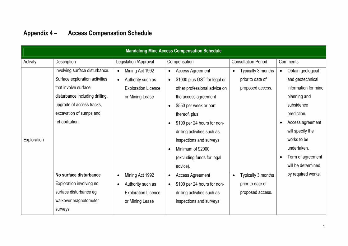
Appendix 4 – Access Compensation Schedule
Mandalong Mine Access Compensation Schedule
Activity Description Legislation /Approval Compensation Consultation Period Comments
Exploration
Involving surface disturbance.
Surface exploration activities
that involve surface
disturbance including drilling,
upgrade of access tracks,
excavation of sumps and
rehabilitation.
Mining Act 1992
Authority such as
Exploration Licence
or Mining Lease
Access Agreement
$1000 plus GST for legal or
other professional advice on
the access agreement
$550 per week or part
thereof, plus
$100 per 24 hours for non-
drilling activities such as
inspections and surveys
Minimum of $2000
(excluding funds for legal
advice).
Typically 3 months
prior to date of
proposed access.
Obtain geological
and geotechnical
information for mine
planning and
subsidence
prediction.
Access agreement
will specify the
works to be
undertaken.
Term of agreement
will be determined
by required works. No surface disturbance
Exploration involving no
surface disturbance eg
walkover magnetometer
surveys.
Mining Act 1992
Authority such as
Exploration Licence
or Mining Lease
Access Agreement
$100 per 24 hours for non-
drilling activities such as
inspections and surveys
Typically 3 months
prior to date of
proposed access.
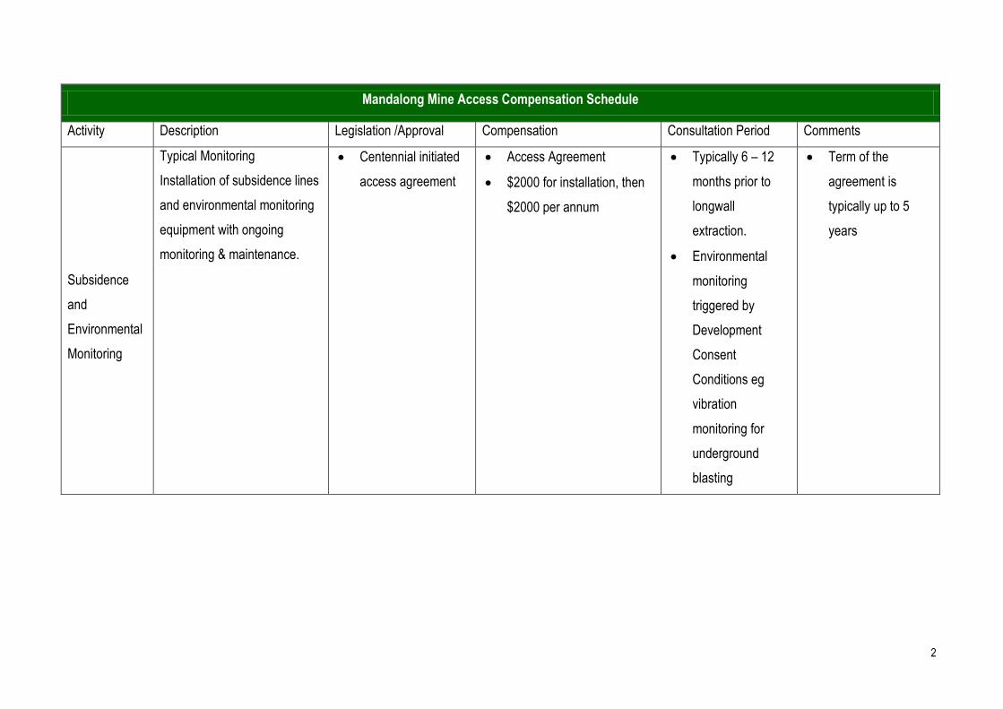
2
Mandalong Mine Access Compensation Schedule
Activity Description Legislation /Approval Compensation Consultation Period Comments
Subsidence
and
Environmental
Monitoring
Typical Monitoring
Installation of subsidence lines
and environmental monitoring
equipment with ongoing
monitoring & maintenance.
Centennial initiated
access agreement
Access Agreement
$2000 for installation, then
$2000 per annum
Typically 6 – 12
months prior to
longwall
extraction.
Environmental
monitoring
triggered by
Development
Consent
Conditions eg
vibration
monitoring for
underground
blasting
Term of the
agreement is
typically up to 5
years
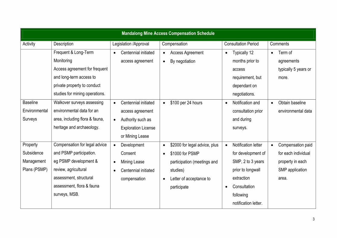
3
Mandalong Mine Access Compensation Schedule
Activity Description Legislation /Approval Compensation Consultation Period Comments
Frequent & Long-Term
Monitoring
Access agreement for frequent
and long-term access to
private property to conduct
studies for mining operations.
Centennial initiated
access agreement
Access Agreement
By negotiation
Typically 12
months prior to
access
requirement, but
dependant on
negotiations.
Term of
agreements
typically 5 years or
more.
Baseline
Environmental
Surveys
Walkover surveys assessing
environmental data for an
area, including flora & fauna,
heritage and archaeology.
Centennial initiated
access agreement
Authority such as
Exploration License
or Mining Lease
$100 per 24 hours Notification and
consultation prior
and during
surveys.
Obtain baseline
environmental data
Property
Subsidence
Management
Plans (PSMP)
Compensation for legal advice
and PSMP participation.
eg PSMP development &
review, agricultural
assessment, structural
assessment, flora & fauna
surveys, MSB.
Development
Consent
Mining Lease
Centennial initiated
compensation
$2000 for legal advice, plus
$1000 for PSMP
participation (meetings and
studies)
Letter of acceptance to
participate
Notification letter
for development of
SMP, 2 to 3 years
prior to longwall
extraction
Consultation
following
notification letter.
Compensation paid
for each individual
property in each
SMP application
area.

Appendix 5 – Mandalong Southern Extension Project
Stakeholder Engagement Plan
Mandalong Southern Extension Project
Stakeholder Engagement Plan
June 2012
Document Control Document Control Details
DOCUMENTDETAILS
Name: Mandalong Southern Extension Project
Stakeholder Engagement Plan
Reference: Fas9419
Revision No.: 7
Document Status Final
REVISION
DETAILS
Rev No.
Date Details of Revision Revised By
0 05/08/09 Draft issued for comment J.Wearne
1 31/8/09 Final J.Wearne
2 27/10/09 Addition of website and local newspaper as methods of communication
J.Wearne
3 09/11/09 Insertion of 1800 number J.Wearne
4 03/05/10 Insertion of consultation flowchart J.Wearne
5 01/02/11 Updated due to changes in Project phase J.Wearne
6 19/8/2011 Updated due to changes in planning legislation
J.Wearne
7 08/06/12 Review as per document schedule. Updated to latest Centennial Coal standard template
J.Wearne
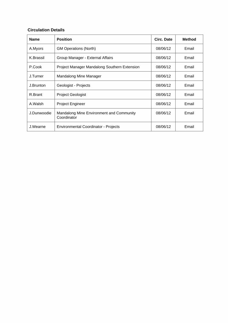
Circulation Details
Name Position Circ. Date Method
A.Myors GM Operations (North) 08/06/12 Email
K.Brassil Group Manager - External Affairs 08/06/12 Email
P.Cook Project Manager Mandalong Southern Extension 08/06/12 Email
J.Turner Mandalong Mine Manager 08/06/12 Email
J.Brunton Geologist - Projects 08/06/12 Email
R.Brant Project Geologist 08/06/12 Email
A.Walsh Project Engineer 08/06/12 Email
J.Dunwoodie Mandalong Mine Environment and Community Coordinator
08/06/12 Email
J.Wearne Environmental Coordinator - Projects 08/06/12 Email
1 INT
1.1
2 EX
2.1
2.2
2.3
3 EN
3.1
3.1
3.1
3.1
3.2
3.3
4 AP
5 STA
5.1
5.2
6 STA
6.1
6.2
6.3
7 CO
8 EX
9 PR
10 C
11 R
12 C
TRODUCTIO
BACKGROU
PLORATION
DESCRIPTIO
EXPLORATI
EXPLORATI
VIRONMEN
DESCRIPTIO
Ecology.1
Archaeo.2
Ground .3
TIMING OF
MINE PLAN
PPROVAL PR
AKEHOLDE
PURPOSE ..
OBJECTIVE
AKEHOLDE
TIER 1 STA
TIER 2 STA
TIER 3 STA
ONSULTATIO
PLORATION
ROJECT CON
COMMUNITY
REVIEW ......
CONTACTS
ON ................
UND ..............
N DRILLING
ON OF THE EX
ION DRILLING
ION TIMING ...
TAL SURVE
ON OF BASEL
y Surveys.....
ological Surv
Magnetic Su
BASELINE EN
NNING ............
ROCESS .....
ER ENGAGE
....................
ES .................
ERS .............
AKEHOLDERS .
AKEHOLDERS .
AKEHOLDERS .
ON STRATE
N DRILLING
NSULTATIO
Y INFORMA
....................
...................
Table
....................
....................
G ...................
XPLORATION A
EQUIPMENT .
....................
EYS AND MI
INE ENVIRONM
....................
veys ..............
urveys ..........
VIRONMENTA
....................
....................
EMENT PLAN
....................
....................
....................
....................
....................
....................
EGIES...........
G CONSULTA
ON PROCESS
ATION LINE .
....................
....................
e of Con
....................
....................
....................
ACTIVITY ......
....................
....................
INE PLANNI
MENTAL ASSE
....................
....................
....................
AL ASSESSMEN
....................
....................
N .................
....................
....................
....................
....................
....................
....................
....................
ATION PRO
S .................
....................
....................
....................
tents
....................
...................
....................
...................
...................
...................
ING ..............
ESSMENTS ....
....................
....................
....................
NTS .............
...................
....................
....................
...................
...................
....................
...................
...................
...................
....................
OCESS ..........
....................
....................
....................
....................
....................
....................
....................
....................
....................
....................
....................
....................
....................
....................
....................
....................
....................
....................
....................
....................
....................
....................
....................
....................
....................
....................
....................
....................
....................
....................
....................
....................
...................
....................
...................
...................
...................
....................
...................
...................
...................
...................
...................
...................
....................
....................
...................
...................
....................
...................
...................
...................
....................
....................
....................
....................
....................
....................
............ 1
............ 1
............ 1
............ 1
............ 1
............ 1
............ 3
............ 3
............ 3
............ 3
............ 3
............ 3
............ 3
............ 4
............ 5
............ 5
............ 5
............ 6
............ 6
............ 6
............ 6
............ 6
............ 7
............ 9
.......... 11
.......... 12
.......... 12
List of Tables TABLE 1 - EXPLORATION DRILLING STAKEHOLDER IDENTIFICATION AND CONSULTATION................................ 7
TABLE 2 – PROJECT STAKEHOLDER IDENTIFICATION AND CONSULTATION .................................................... 9
TABLE 3 – CONCEPTUAL CONSULTATION TIMELINE ................................................................................... 10
Figures FIGURE 1 - TYPICAL DRILL SITE LAYOUT (NOT TO SCALE) ........................................................................... 2
FIGURE 2 – PROJECT PROCESS AND APPROVAL FLOWCHART ...................................................................... 4
FIGURE 3 – EXPLORATION DRILLING CONSULTATION FLOWCHART ............................................................... 8
Appendices APPENDIX 1 - MANDALONG SOUTHERN EXTENSION PROJECT AREA ........................................................... 13
List of Abreviations
MLS Mandalong South.
EL Exploration Licence (refer Mining Act 1992).
NGO Non government organisation.
Project Mandalong Southern Extension Project.
CCC Mandalong Mine Community Consultative Committee.
LGAs Local Government Areas
Centennial Centennial Coal Company Limited
Centennial Mandalong Centennial Mandalong Pty Limited
Mandalong Southern Extension Project Stakeholder Engagement Plan
Page 1
1 Introduction
1.1 Background
Mandalong Mine (Mandalong) is an underground longwall coal mining operation located in the Lake Macquarie Local Government Area (LGA) approximately 130 kilometres north of Sydney near Morisset. Mandalong is operated by Centennial Mandalong Pty Ltd (Centennial Mandalong), a wholly owned subsidiary of Centennial Coal Company Limited (Centennial), and supplies coal to both domestic and export markets.
Centennial Mandalong is currently undertaking an exploration drilling programme over its Exploration Licence area (EL6317) referred to as the Mandalong Southern Extension Project area (see Appendix 1). The Project area is located south-west of the township of Morisset and west of the township of Wyee within the Lake Macquarie and Wyong LGAs. The Project area is predominantly privately owned rural land however also includes land owned by Centennial Fassifern Pty Ltd, Wyong Shire Council, the Olney State Forest and the Jilliby State Conservation Area.
Exploration drilling commenced within the Project area in January 2010 and will continue until mid 2012. In addition to the exploration drilling programme currently being undertaken, Centennial Mandalong is seeking approval under Part 4 of the Environmental Planning and Assessment Act 1979 for the continuation and extension of the Mandalong Mine south into the Project area. The mine planning and design process has taken into consideration the information obtained from the exploration drilling programme as well as environmental and surface features which include buildings, transmission lines, roads etc.
2 Exploration Drilling
2.1 Description of the Exploration Activity
The exploration drilling programme consists of approximately fifty three exploration boreholes across the area being drilled vertically to intersect and recover the target strata. The surface exploration boreholes will be drilled to build on existing information on coal quality and geological conditions of this resource for potential future underground mining.
Some minor surface clearance is likely to be required to establish each drill site. Where possible, drill sites are selected as close as possible to existing access roads/tracks to minimise clearing requirements. The drilling footprint at each exploration hole will require a disturbance area of approximately 25m x 25m (sites are located in existing cleared areas wherever possible). Two sumps, approximately 2m x 2m x 2m in dimension, will be excavated at each drill site. Drilling activities require the construction of sumps to collect drill cuttings and to control and recycle drilling fluids down the borehole. The general layout of a typical drill site is shown in Figure 1 below. Each drill site will be rehabilitated at the completion of drilling activities.
2.2 Exploration Drilling Equipment
At each drill site the key equipment used will include a drill rig, support truck, light vehicles and an air compressor (used only where resistant drilling conditions are encountered). Site and access preparation equipment will require the use of an excavator, bobcat and truck. A water cart will supply water to the site for use in the drilling process and dust suppression if and where required.
2.3 Exploration Timing
Standard operating hours will be between 7 am and 6 pm, Monday to Friday. If and when required, incidental works may also be carried out on Saturday mornings between 8 am to 1 pm. The anticipated duration of drilling at each site is approximately three weeks depending on borehole depth and site conditions encountered. Exploration drilling commenced in January 2010 and will continue until mid 2012.
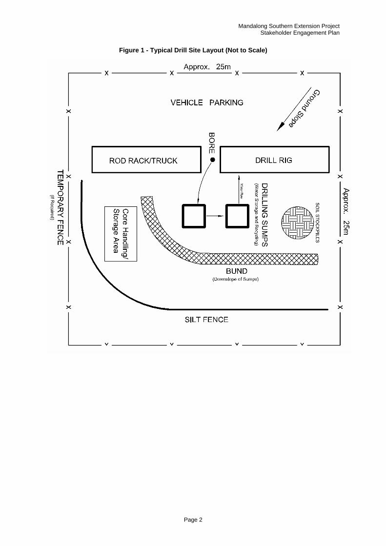
Mandalong Southern Extension Project Stakeholder Engagement Plan
Page 2
Figure 1 - Typical Drill Site Layout (Not to Scale)
3
3.1
In order the projeThis infoactivitiesenvironm
3.1.1
Ecologic
• Identifi
• Target
• Faunapresen
Targetedthe studand the
Fauna smost act
• Day an
• Frog se
• Trappin
3.1.2
Archaeocommun
3.1.3
Ground such astheir whwalks acthe earth‘strip’ wi
3.2
The bas
3.3
A mine of the pr
Environm
Descriptio
r to develop ect team to ormation is us and ensumental const
Ecology S
cal surveys in
cation and m
ed searches
a surveys invnt or likely to
d threateneddy area to ideabundance o
surveys are otive. Fauna s
nd night surv
earches; and
ng and hair t
Archaeolo
ological survnity to identify
Ground M
magnetic sus dykes and hereabouts iscross the groh. The lines th a specifie
Timing of
seline environ
Mine Plan
plan has beeroject area.
mental Surv
on of Baselin
suitable minhave a com
used to adeqre any min
traints.
Surveys
nvolve three
mapping the d
s for rare or th
volving targeo occur within
d flora and ventify the exof any threat
often undertasurveys will i
veys;
d
tube samplin
ogical Surve
veys are undfy the locatio
Magnetic Sur
urveys are ussome faults
s very usefuound in straigwalked are d width and
Baseline En
nmental asse
ning
en determine
veys and M
ne Environm
ne plans for prehensive u
quately assesne plans de
key aspects
distribution o
hreatened flo
eted searchen the Project
vegetation suxtent of the dtened flora.
aken over a fnvolve:
ng.
eys
dertaken by n of sites of A
rveys
sed to gathe. These feat
ul informatioght lines cargenerally splength.
nvironmenta
essments ha
ed taking int
Page 3
Mine Planni
mental Asse
coal extractiunderstandinss potential
eveloped ca
s including:
of different ve
ora species;
es, spotlightinarea.
urveys requidifferent vege
few days dur
an archaeoAboriginal si
er informationtures are gen. The surv
rrying equipmpaced 10m a
al Assessm
ave been com
to considerat
Ma
ing
essments
ion within theng of all aspimpacts fromn be develo
egetation com
and
ng and trapp
re random metation comm
ring spring an
ologist and rgnificance.
n on the posenerally difficeys are carr
ment that meapart which a
ents
mpleted.
tion environm
andalong SoutStakeho
e Project areects of the e
m any future oped with c
mmunities ov
ping to ident
meanders tomunities pres
nd summer w
representativ
sible locationcult to mine ried out by aasures the m
are confined
mental and in
thern Extensioolder Engagem
ea, it is impoexisting envi undergrounconsideration
ver the Proje
tify what ani
o be undertasent and the
when the ani
ves of the A
n of magnetthrough, so a field oper
magnetic reswithin a bou
nfrastructure
on Project ment Plan
ortant for ronment.
nd mining n to the
ect area;
mals are
ken over e location
imals are
Aboriginal
ic bodies knowing
ator who sponse of undary or
e aspects
Mandalong Southern Extension Project Stakeholder Engagement Plan
Page 4
4 Approval Process
Centennial has commenced the preparation of a detailed environmental assessment of the project which will be submitted to the NSW Department of Planning and Infrastructure for assessment. Approval for any proposed mining within the Mandalong Southern Extension Project Area will be considered under Part 4 of the Environmental Planning and Assessment Act 1979. Figure 2 below details the mine planning and approval process for the Project.
Figure 2 – Project Process and Approval Flowchart
Mandalong Southern Extension Project Stakeholder Engagement Plan
Page 5
5 Stakeholder Engagement Plan
5.1 Purpose
The purpose of the Stakeholder Engagement Plan is to provide a consistent management framework to identify and consult with stakeholders with an interest in the Mandalong Southern Extension Project.
5.2 Objectives
Centennial places the utmost importance on maintaining effective communication with the local communities and other stakeholders in which it operates. A stakeholder database has been developed for the Project. The database is the repository for communications between Centennial and its stakeholders.
The objectives of the Stakeholder Engagement Plan are to:
Set a process for engagement with stakeholders of interest, with clear desired outcomes for the Company and stakeholders;
Openly communicate with stakeholders about the Mandalong Southern Extension Project; and
Provide a means of community access to the project team via a dedicated information phone line.
Mandalong Southern Extension Project Stakeholder Engagement Plan
Page 6
6 Stakeholders
A range of stakeholders have been identified for inclusion in the consultation strategies outlined in this Plan. These stakeholders include local and State government agencies, local businesses and industries, private landholders and Centennial employees. These stakeholders have been divided into three tiers depending on their level of impact or involvement in the Mandalong Southern Extension Project.
6.1 Tier 1 Stakeholders
Tier 1 represents those stakeholders that are either potentially directly impacted (or considered a high risk of being impacted) by the project. This can include private landholders, near neighbours or businesses. Tier 1 stakeholders also include government agencies that have an authority of approval for activities to be carried out.
6.2 Tier 2 Stakeholders
Tier 2 stakeholders have been identified as those landholders or organisations that are not considered Tier 1 stakeholders and that are located within the boundary of the Exploration Licence (EL6317) area. Tier 2 stakeholders also include government agencies that may have an input into the approval process.
6.3 Tier 3 Stakeholders
Tier 3 stakeholders consist of all other residents that have registered an interest in the Mandalong Southern Extension Project, local and State government organisations, Local, State and Federal Members of Parliament, local and regional businesses, Centennial employees and regional Non-Government Organisations (NGO’s). These stakeholders will be considered when undertaking the consultation process and communicated with as necessary.
7 Consultation Strategies
A range of measures will be utilised by Centennial to provide information to the relevant stakeholders on its proposed activities throughout the exploration programme. These will include:
Letters;
Newsletters;
Face to face meetings;
Information sessions;
Open days;
Local newspapers;
Centennial Coal website; and
Mandalong Mine Community Consultative Committee (CCC).
Mandalong Southern Extension Project Stakeholder Engagement Plan
Page 7
8 Exploration Drilling Consultation Process
Table 1 and Figure 2 below details the consultation process undertaken for each exploration drilling location.
Table 1 - Exploration Drilling Stakeholder Identification and Consultation
Tier Contact Method
1
Residential/Landholder – if drilling is likely to impact directly on the residence.
Face to face meeting
Letter
Newsletter
Centennial Coal website
Local newspaper
Landowners neighbouring properties on which exploration drilling activities are being undertaken.
Letter
Face to face meeting (if requested)
Landowners/occupiers whose principal place of residence is located within 450 metres of an exploration drill site.
Letter
Face to face meeting (if requested)
Government agencies – Required in obtaining approvals for drilling activities.
Letter
Meetings
2
Residential/Landholder – all other residents located within EL6317.
Newsletter
Centennial Coal website
Local newspaper
Government agencies – if input is required in approval process.
Letter
Newsletter
Meetings
3
Residential/Landholder – Residents that have an interest in the Mandalong South exploration programme.
Local newspaper
Centennial Coal website
Newsletter (if requested)
Government agencies/local businesses/NGO’s who may have an interest in the Mandalong South exploration programme.
Centennial Coal website
Newsletter (if requested)
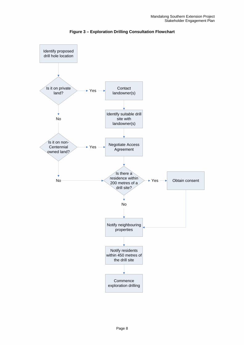
Mandalong Southern Extension Project Stakeholder Engagement Plan
Page 8
Figure 3 – Exploration Drilling Consultation Flowchart
Identify proposed drill hole location
Is it on private land?
Contact landowner(s)
Obtain consent
Notify residents within 450 metres of
the drill site
Notify neighbouringproperties
Negotiate Access Agreement
Identify suitable drill site with
landowner(s)
Commence exploration drilling
Is there a residence within 200 metres of a
drill site?
Yes
No
Yes
No
Is it on non-Centennial
owned land?Yes
No
Mandalong Southern Extension Project Stakeholder Engagement Plan
Page 9
9 Project Consultation Process
Tables 2 and 3 details the consultation strategies and timing that will be used by Centennial Mandalong to consult with relevant stakeholders regarding the Mandalong Southern Extension Project.
Table 2 – Project Stakeholder Identification and Consultation
Tier Contact Method
1
Residential/Landholder – All residents impacted by activities associated with the environmental surveys.
Face to face meeting
Letter
Newsletter
Centennial Coal website
Local newspaper
Information sessions
Open days
Government agencies who have an authority of approval.
Letter
Meetings
Registered Aboriginal Persons/Groups. In accordance with Aboriginal Consultation Strategy
2
Residential/Landowner – all other residents located within EL6317.
Newsletter
Centennial Coal website
Local newspaper
Information Sessions
Open days
Face to Face meetings (if requested)
Government agencies – if input is required in approval process.
Letter
Meetings
3
Residential/Landholder – Residents that have an interest in the Mandalong Southern Extension Project.
Local newspaper
Centennial Coal website
Newsletter (if requested)
Government agencies/local businesses/NGO’s who may have an interest in the Mandalong South exploration programme.
Centennial Coal website
Newsletter (if requested)

Mandalong Southern Extension Project Stakeholder Engagement Plan
Page 10
Table 3 – Conceptual Consultation Timeline
Date Medium Content
October 2009 Newsletter Introduction to the project
February 2010 Mandalong CCC Update on project
June 2010 Newsletter Update on project
June 2012 Mandalong CCC Update on project
October 2010 Open Day Exploration drill site open to interested stakeholders
November 2010 Information Flyer Details on environmental surveys and access agreement negotiation process
November 2010 Mandalong CCC Update on project
February 2011 Newsletter Update on project
May 2011 Mandalong CCC Update on project
June/July 2011 Information Session
Information sessions on subsidence
July 2011 Mandalong CCC Update on project
September 2011 Newsletter Update on project
September 2011 Mandalong CCC Update on project
October 2011 Information Session
Information sessions on groundwater and Aboriginal heritage
February 2012 Mandalong CCC Update on project
May 2012 Information Session
Mine planning options
May 2012 Newsletter Update on project
May 2012 Meetings Discuss surface infrastructure options with potentially impacted landowners
May 2012 Site visit Site visit of surface facility location options with potentially impacted landowners
June 2012 Mandalong CCC Update on Project
September 2012 Mandalong CCC Update on project
October 2012 Information Sessions
Information sessions on the results of the EIS technical studies
October 2012 Newsletter Update on project
Mandalong Southern Extension Project Stakeholder Engagement Plan
Page 11
December 2012 Mandalong CCC Update on project
November 2012 Letter Notification of EIS submission
November 2012 Advertisement Advertisement in the local paper notifying of EIS submission
March 2013 Newsletter Update on project
March 2013 Mandalong CCC Update on project
10 Community Information Line
The community are able to seek additional information or make complaints about the Project via a dedicated phone line. The Mandalong South Project Community Information Line is 1800 731 966. Although this is not manned 24 hours a day, the message bank will be checked and a follow up response made as soon as practicable.
Mandalong Southern Extension Project Stakeholder Engagement Plan
Page 12
11 Review
This Stakeholder Engagement Plan should be reviewed regularly and updated as required. Any additional stakeholders identified during the course of the Project will be added to the database and communicated with through the appropriate methods.
12 Contacts
The Key Contacts for the Mandalong Southern Extension Project are outline below. For any community questions or concerns relating to this Project, please contact the Environment and Community Coordinator (Projects). Any media enquiries should be directed to the Centennial Coal Group Manager – External Affairs.
James Wearne – Environment and Community Coordinator (Projects)
Phone: 0407 207 530
Email: [email protected]
Katie Brassil – Group Manager (External Affairs)
Phone: (02) 49358937
Email: [email protected]
Peter Cook – Mandalong Southern Extension Project Manager
Phone: 0406 384 421
Email: [email protected]
John Brunton – Geologist (Projects)
Phone: (02) 49358905
Email: [email protected]
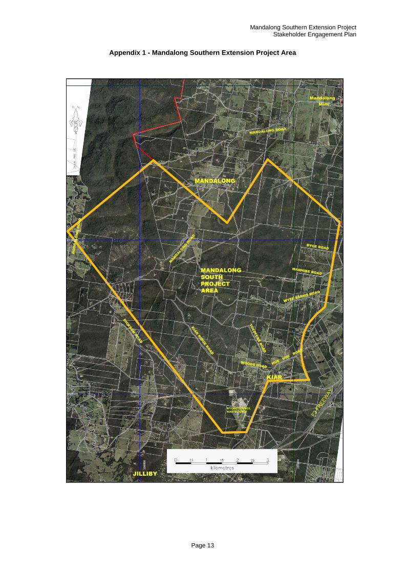
Mandalong Southern Extension Project Stakeholder Engagement Plan
Page 13
Appendix 1 - Mandalong Southern Extension Project Area

Centennial Coal Company Limited P O Box 1000 Toronto NSW 2283
www.centennialcoal.com.au