Landing stages of Jakarta / Batavia - Dirk Teeuwen...
23
1 Landing stages of Jakarta / Batavia The roads of Batavia and Sunda Kelapa / De rede van Batavia en het Havenkanaal By Dirk Teeuwen A word after a slash, in the text below and above, is the same word, title or name in Dutch. V. O. C. means Dutch East India Company / Vereenigde Oost-Indische Compagnie Contents Pictures are available on request. I. Introduction II. Jacatra and the settlement of the Dutch III. Growth of Batavia VI. English intermezzo (1811-1815) and further growth V. Some dates VI. Groote Boom, Kleine Boom, Landingsplaats and Stadsherberg VII. Watch Tower “De Uitkijk” (1830) on V.O.C.-bastion Culemborg, V.O.C.- warehouses and entrepôts (west side warehouses, now Museum Behari) (1650), V.O.C.-bastion Zeeburg (1650), the moat of Old Batavia, V.O.C.-bastion Groningen VIII. Account for pictures 22 pages I. Introduction I.a Aim of the article The aim of this article is to describe very briefly a couple of selected aspects of the development of the city of Jakarta / Batavia from 1619 until 1900 and to illustrate this richly with pictures of, and comments on, the historical phenomenon Sunda Kelapa / Havenkanaal. In the Dutch Period of Indonesia Jakarta’s Sunda Kelapa was a harbour canal and formed a part of a port system (from 1619 until 1886). This port system consisted of a lot of divisions: - Pulau Onrust / Eiland Onrust (Island Onrust, shipbuilding); - Anchorage Bay of Batavia (transit of goods and passengers, logistics of goods and passengers as well as their luggage); - Harbour Canal (logistics to and from Anchorage Bay and customs formalities); - Kali Besar (logistics, local transhipment); - Warehouses – storehouse – entrepôts around the Harbour Canal (Sunda Ke;apa / Havenkanaal). ©2007 drs (msc) D. Teeuwen - Rendez-vous Batavia – The Netherlands
-
Upload
nguyenmien -
Category
Documents
-
view
223 -
download
1
Transcript of Landing stages of Jakarta / Batavia - Dirk Teeuwen...

1
Landing stages of Jakarta / Batavia The roads of Batavia and Sunda Kelapa / De rede van Batavia en het Havenkanaal
By Dirk Teeuwen
A word after a slash, in the text below and above, is the same word, title or name in Dutch. V. O. C. means Dutch East India Company / Vereenigde Oost-Indische Compagnie
Contents
Pictures are available on request. I. Introduction II. Jacatra and the settlement of the Dutch III. Growth of Batavia VI. English intermezzo (1811-1815) and further growth V. Some dates VI. Groote Boom, Kleine Boom,
Landingsplaats and Stadsherberg VII. Watch Tower “De Uitkijk” (1830) on V.O.C.-bastion Culemborg, V.O.C.-warehouses and entrepôts (west side warehouses, now Museum Behari) (1650), V.O.C.-bastion Zeeburg (1650), the moat of Old Batavia, V.O.C.-bastion Groningen VIII. Account for pictures
22 pages
I. Introduction
I.a Aim of the article
The aim of this article is to describe very briefly a couple of selected aspects of the development of the city of Jakarta / Batavia from 1619 until 1900 and to illustrate this richly with pictures of, and comments on, the historical phenomenon Sunda Kelapa / Havenkanaal. In the Dutch Period of Indonesia Jakarta’s Sunda Kelapa was a harbour canal and formed a part of a port system (from 1619 until 1886). This port system consisted of a lot of divisions: - Pulau Onrust / Eiland Onrust (Island Onrust, shipbuilding); - Anchorage Bay of Batavia (transit of goods and passengers, logistics of goods and passengers as well as their luggage); - Harbour Canal (logistics to and from Anchorage Bay and customs formalities); - Kali Besar (logistics, local transhipment); - Warehouses – storehouse – entrepôts around the Harbour Canal (Sunda Ke;apa / Havenkanaal).
©2007 drs (msc) D. Teeuwen - Rendez-vous Batavia – The Netherlands

2
P.I.1 Sunda Kelapa and vicinity, Jakarta / Batavia 1951
This article looks like a walk with pictures around the old harbour Sunda Kelapa, part of Jakarta-Kota. The numbers on picture P.1 are some selected locations, worthy of a moment of rest and contemplation in chapter VI on page .. below, etc. The numbers on P.1.a supplied with explanation: 1. the former location of the Large Customs Post / Groote Boom (new location from 1850); 2. formerly the Landing Place and the Small Customs Post / Kleine Boom 3. the City Inn / Stadsherberg (1850); 4. left from the figure three you can see, with some imagination, a drawbridge / ophaalbrug, while the area across this bridge (south of it) was the location of the castle of the Dutch East-Indian Company (V.O.C.); 5. a bridge over Kali Besar, in front this still existing bridge there are now a dam and a sluice; 6. the Watch Tower / De Uitkijk (1830) built on V.O.C.-bastion Culemborg (1650); 7. V.O.C.-warehouses and entrepôts (west side warehouses, now Museum Behari) (1650); 8. V.O.C.-bastion Zeeburg (1650); 9. the moat of Old Batavia, part of the old defence lines of the city; 10.V.O.C.-bastion Groningen, not visible on this picture; 11. former location of Pasar Ikan; 12. Sunda Kelapa / Havenkanaal (Harbour Canal).
I.b Some comments on this explanation (sub P.I.1)
- The Dutch word “boom” means “tree” and in outdated Dutch it means “barrier” also. - In the upper left corner of this picture P.1 one can catch a glimpse of V.O.C.-warehouses and entrepôts (eastside warehouses). - The now existing dam in front of the bridge over Kali Baru is not the first one. In 1825 the Dutch built a dam on the same spot. The dam was necessary because of the continuous flows of mud and rubbish into the Harbour Canal from Kali Besar, River Ciliwung and from the city of Batavia. This was a expensive affair. In fact there were two mudflows: one from the mainland and one from the seaside. The first dam from 1825 has been cut in 1910 after the opening of Tanjung Priok Harbour / Tandjoeng Priok in 1886. Dutch dredging technology was at that moment much more developed. - Jakarta Kota was Old Batavia during the Dutch Period. Sunda Kelapa means Coconut Harbour, a name from the Indonesian Hindu era before 1520. In the Dutch period Sunda Kelapa was Havenkanaal, Dutch for Harbour Channel.
©2007 drs (msc) D. Teeuwen - Rendez-vous Batavia – The Netherlands

3
II. Jacatra and the settlement of the Dutch
P.II.1 “The city of Batavia in the island of Java and capital of all the Dutch factories and
settlements in the East Indies”, Jakarta / Batavia 1754
The old town of Batavia was built on the spot where originally Jacatra or Jayakarta was situated, which place was the residence of a pangeran (prince) who was dependent on the sultan of Bantam. By an agreement made in November 1610 by the Jacques l’Hermite, president of the Dutch Bantam factory / factorij, with the Pangeran of Jacatra, the Dutch firmly established themselves there. In the meantime Pieter Both, the first governor-general of The Dutch East Indies had been instructed by the Dutch East India Company to look out for a place suitable for a settlement. The Dutch were fed up to the chicaning practices of the sultan of Bantam. The sultan obstructed the intake of cargoes (pepper) by the Dutch, he set the English, the Portuguese and Dutch against each other and he levied extreme import as well as export duties as he pleased. The Dutch were not able to cope with Javanese culture and their behaviour was a paragon of rudeness. The watchful eye of Pieter Both fell on Jacatra. He succeeded in getting a piece of land there peacefully and at once the Dutch began building a house to serve as an official residence. In 1613 Jan Pietersz. Coen was appointed by Pieter Both director of the posts at Bantam and Jacatra. Five years later Jacatra was garrisoned by Coen with 22 men. Owning to the continuous plotting and intriguing by the English there soon arose difficulties and discord between Coen and the pangeran of Jacatra. Coen decided to build a fortress. The situation however became critical, and on January 2nd 1619 Coen weighed anchor and sailed to the Moluccas in order to get reinforcements. Pieter van den Broeck was appointed commander of the fortress in Coen’s place. While Van Den Broeck was engaged in negotiations with the Jacatrans the latter succeeded in capturing the Dutch commander. The fortress was dangerously threatened by the sultan of Banten / Bantam, the pangeran of Jacatra and the English. Then malaria, cholera and dysentery caused many deaths and the Dutch defenders gradually lost their courage. Believe it or not: the following happened. To enable them to forget their sorrow and to reanimate their courage, a big feast was organized by infantry captain Van Raay on March 12th 1919. Van Raay was the successor of Van den Broeck. On occasion of the feast the four bastions of the fortress were baptised in the names of Holland, Zeeland, West-Friesland and Gelderland, while the fortress itself was named Batavia. On May 16th 1619 Coen returned with sixteen ships and a considerable military force and was received with great acclaim. On May 30th 1619 Coen attacked Jacatra, seized it, and razed it to the ground. The name Batavia remained. Pieter van den Broeck survived all turbulences. The same went for Van Raay (obviously, of course), the pangeran ( not so obviously) but not for his subjects and for many Englishmen (they deserved their fate, that is, according to Coen).
III. Growth of Batavia (1629-1811)
The settlement began to grow rapidly. In vain it was attacked and besieged repeatedly in 1628 and 1629 by the Javanese sultan of Mataram (now Jokyakarta). Soon a thriving commercial town had risen on the site of old Jacatra, which developed and extended more and more. The population was
©2007 drs (msc) D. Teeuwen - Rendez-vous Batavia – The Netherlands

4
P.III.1 The only picture of Kampung Jayakarta (artist unknown), Java1607
heterogeneous, but consisted for the greater part of Chinese, the number of whom increased to such a degree, that the Europeans regarded it as a possible danger. This opinion caused the government to treat the Chinese with the greatest severity. These actions and a temporarily economic depression concerning the sugar industry around Batavia (which caused a lot of unemployment and poverty among the Chinese) were the causes of a rebellion of those Chinese, who had left the town and those who were already tramping around Batavia.
P.III.2 Jakarta / Batavia 1619 P.III.3 Jakarta / Batavia 1628 ©2007 drs (msc) D. Teeuwen - Rendez-vous Batavia – The Netherlands

5
P.III.4 Artillery on the northern bastions of the V. O. C.-castle, Batavia 1770
The Batavians feared that the former would act together with the thousands of Chinese inside the town to murder the Europeans. Strengthened by the serious threatening of Semarang, east of Batavia, by Chinese gangs, this fear grew to such a degree that it expressed itself in a terrible slaughter of the Chinese inside the town of Batavia on October 17th 1740. On this occasion about 10.000 Chinese lost their lives. In the meantime malaria, dysentery as well as cholera demanded in a short space of time thousands of victims. For us the explanation is obvious. Old Batavia was situated at the mouth of the river Ciliwung and on a marshy soil. Moreover the town consisted of closed houses, narrow streets and a lot of canals. The canals served as an open sewer as well as a drinking-water supply and were also waste pipes on behalf of the sugar factories. There were a lot of muddy fish farms. Lack of hygiene and excess of malaria mosquito’s caused a lot of problems. Official reports recorded a deathroll of 87.000 people (soldiers and sailors included) in the government hospitals during the years 1714 to 1776. In the course of 21 years and eight months (1731-1752) 1.119.375 died in Batavia (inside and outside the hospitals). Fever raged most fiercely between the years 1733 and 1738, when 2.000 people, in the service of the Dutch East India Company and free Christians (not in the V.O.C.-service) died yearly. Yet it was not until 1808, under the governorship of Herman Willem Daendels, that the old town was abandoned and the inhabitants settled on higher ground, later on known as Weltevreden, a name which was taken from an estate in that area. Daendels founded a new town with broad streets and airy, open houses. Much later enormous sums of money have been spent on the water supply and various measures have been taken to improve the healthfulness of Batavia, so that cholera was heard of after 1890. Batavia became one of the healthiest towns in the Far East. Daendels also began the construction of the palace on Lapangan Banteng / Waterlooplein (Waterloo Square). Later the palace became The office of the Department of Finance. The work was finished (to be honest) much, much later under governor-general Leonard Pierre Joseph, Burggraaf (Viscount), Du Bus de Gisignies in 1826.
IV. English intermezzo (1811-1815) and further growth
In 1811 an English fleet under the command of Lord Pinto cast anchor in the roadsteads of Batavia. After military resistance Batavia fell into the hands of the English. Sir Stamford Raffles was appointed governor-general. By the Treaty of London, August 14th 1814, England gave most of the Dutch colonies back to the Netherlands. After the defeat of Napoleon by the English, Dutch and Prussians England had no reason to fear that The Dutch East Indies would fall into the hands of the French. The English wanted no competitors in the Far East. From 1814 the Dutch acted as colonial allies of the British. The Dutch flag was again hoisted at Batavia and stayed there until 1950. From 1942 until 1945 the Japanese occupation caused an economic and human disaster. Europeans, Indo’s and Chinese suffered severely. But the terrible suffering of the Indonesian population deserves particular attention. The Japanese excelled in murder, rape and plundering.
©2007 drs (msc) D. Teeuwen - Rendez-vous Batavia – The Netherlands
6
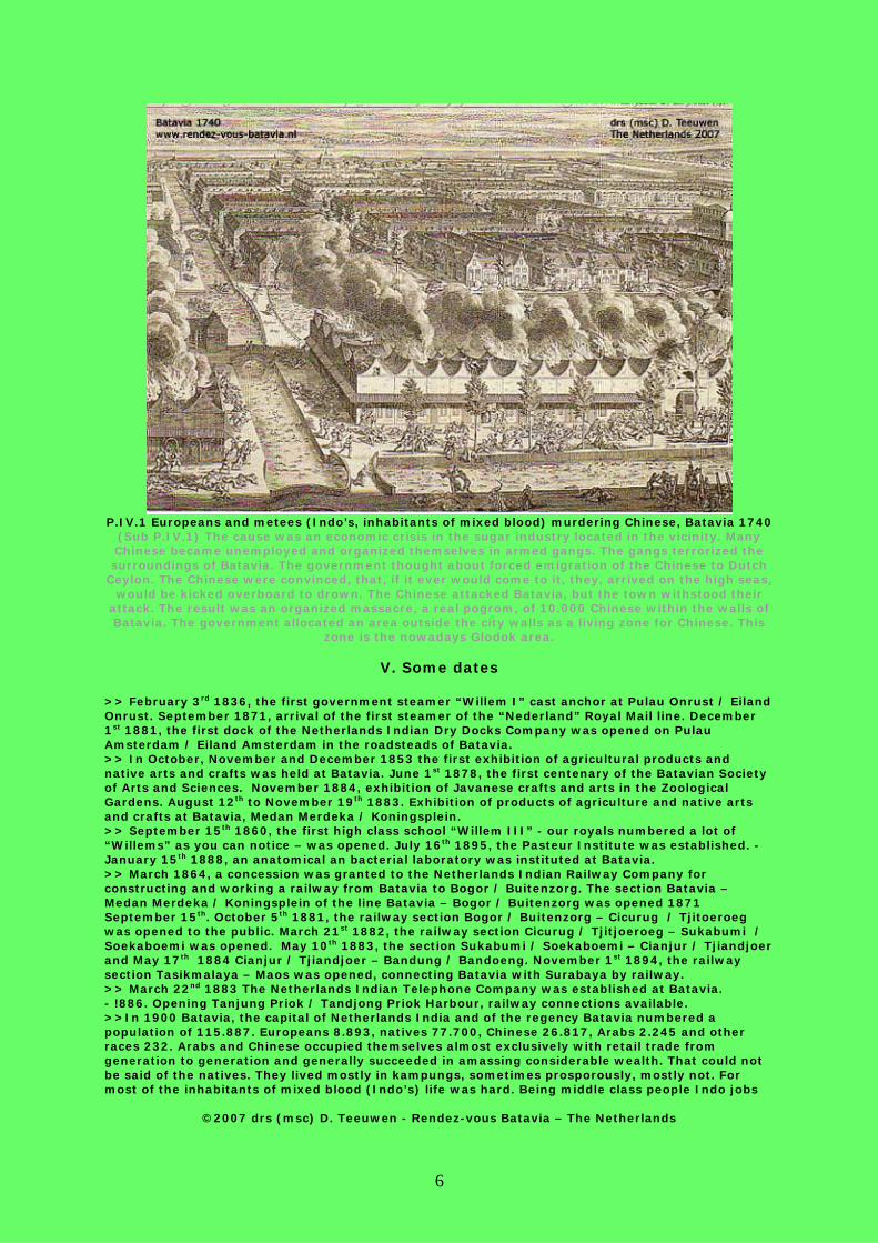
P.IV.1 Europeans and metees (Indo’s, inhabitants of mixed blood) murdering Chinese, Batavia 1740
(Sub P.IV.1) The cause was an economic crisis in the sugar industry located in the vicinity. Many Chinese became unemployed and organized themselves in armed gangs. The gangs terrorized the surroundings of Batavia. The government thought about forced emigration of the Chinese to Dutch
Ceylon. The Chinese were convinced, that, if it ever would come to it, they, arrived on the high seas, would be kicked overboard to drown. The Chinese attacked Batavia, but the town withstood their
attack. The result was an organized massacre, a real pogrom, of 10.000 Chinese within the walls of Batavia. The government allocated an area outside the city walls as a living zone for Chinese. This
zone is the nowadays Glodok area.
V. Some dates
>> February 3rd 1836, the first government steamer “Willem I” cast anchor at Pulau Onrust / Eiland Onrust. September 1871, arrival of the first steamer of the “Nederland” Royal Mail line. December 1st 1881, the first dock of the Netherlands Indian Dry Docks Company was opened on Pulau Amsterdam / Eiland Amsterdam in the roadsteads of Batavia. >> In October, November and December 1853 the first exhibition of agricultural products and native arts and crafts was held at Batavia. June 1st 1878, the first centenary of the Batavian Society of Arts and Sciences. November 1884, exhibition of Javanese crafts and arts in the Zoological Gardens. August 12th to November 19th 1883. Exhibition of products of agriculture and native arts and crafts at Batavia, Medan Merdeka / Koningsplein. >> September 15th 1860, the first high class school “Willem III” - our royals numbered a lot of “Willems” as you can notice – was opened. July 16th 1895, the Pasteur Institute was established. - January 15th 1888, an anatomical an bacterial laboratory was instituted at Batavia. >> March 1864, a concession was granted to the Netherlands Indian Railway Company for constructing and working a railway from Batavia to Bogor / Buitenzorg. The section Batavia – Medan Merdeka / Koningsplein of the line Batavia – Bogor / Buitenzorg was opened 1871 September 15th. October 5th 1881, the railway section Bogor / Buitenzorg – Cicurug / Tjitoeroeg was opened to the public. March 21st 1882, the railway section Cicurug / Tjitjoeroeg – Sukabumi / Soekaboemi was opened. May 10th 1883, the section Sukabumi / Soekaboemi – Cianjur / Tjiandjoer and May 17th 1884 Cianjur / Tjiandjoer – Bandung / Bandoeng. November 1st 1894, the railway section Tasikmalaya – Maos was opened, connecting Batavia with Surabaya by railway. >> March 22nd 1883 The Netherlands Indian Telephone Company was established at Batavia. - !886. Opening Tanjung Priok / Tandjong Priok Harbour, railway connections available. >>In 1900 Batavia, the capital of Netherlands India and of the regency Batavia numbered a population of 115.887. Europeans 8.893, natives 77.700, Chinese 26.817, Arabs 2.245 and other races 232. Arabs and Chinese occupied themselves almost exclusively with retail trade from generation to generation and generally succeeded in amassing considerable wealth. That could not be said of the natives. They lived mostly in kampungs, sometimes prosporously, mostly not. For most of the inhabitants of mixed blood (Indo’s) life was hard. Being middle class people Indo jobs
©2007 drs (msc) D. Teeuwen - Rendez-vous Batavia – The Netherlands

7
were occupied by natives more and more because of the increasing attention of the colonials to ethical politics. This emancipation was the basis of the Indonesians efforts to achieve independence.
P.IV.2 Pulau Onrust / Eiland Onrust, painting by A. Storck, Batavia Bay 1799
(Sub P.IV.2) Pulau Onrust was allocated as a shipbuilding yard because sea-going vessels could not reach Sunda Kelapa / Havenkanaal because of mud flats. In front, left from the middle, the (daily) arrival of the proa of the bargeman assigned to regular service (Batavia – Onrust vice versa). The
English under the command of admiral Ball destroyed Pulau Onrust in 1800. In 1823-1825 governor-general Van De Capellen ordered to repair the yard. In 1856 a floating dock was built. Because of the expansion of the harbour works near Surabaya /Soerabaja and because of the opening of Tanjung Priok Batavia Harbour / Tandjoeng Priok in 1886 the importance of Pulau Onrust faded away. From 1911 Pulau Onrust and Pulau Kuiper functioned as “Tanjung Priok
Quarantine Stations” meant for Mecca pilgrims.
P.IV.3
©2007 drs (msc) D. Teeuwen - Rendez-vous Batavia – The Netherlands

8
(Sub P.IV.3) This lithograph is of the Watch Tower, the Landing Place (and Small Customs Post as well) and the City Inn, Jakarta / Batavia 1880
Left the front of the City Inn, far left the Castle Bridge, right the pendopo of the Landing Place and the Watch Tower.
P.IV.4 Detail of a map, Batavia 1897 P.IV.5 Detail of a map, Batavia 1914
VI. Groote Boom, Kleine Boom, Landingsplaats and Stadsherberg
(Large Customs Post, Small Customs Post, Landing Place and City Inn, 1, 2, 3, 4,5, 11, 12 on P.I.1)
This chapter and the chapters following one is the result of some research concerning some selected historical locations around Sunda Kelapa as showed on P.I.1 on page 1. In the first place, in VI.a, a couple of photographs to stir up memories. Then, in VI.b recent as well as historical pictures and remarks about Sunda Kelapa / Havenkanaal are arranged comparatively as far as possible. That means: as far as possible with my personal collection. Contrary to the chapters I, II, IV,V the text is linked to the photographs.
VI.a At first some pictures as an introductory
©2007 drs (msc) D. Teeuwen - Rendez-vous Batavia – The Netherlands

9
P.VI.1 Buginese schooners in Sunda Kelapa / Havenkanaal, Jakarta Kota / Oud Batavia 2006
Until 1619 a small centre of pepper trade, after 1619 until 1886 the harbour of Netherlands India’s Batavia. In 1886 Tanjung Priok Harbour / Tandjoeng Priok came into operation.
P.VI.2 Sunda Kelapa, coolie work, Jakarta 1993
Corvées and coolies were - and are – an phenomenon in the Far East. Modern Indonesia has, like the Dutch colonials had, a problem with poverty. Overpopulation at Java and the rush from the country-
side to the city 9from 1920 until now) were –and are- a problem for a long time now.
©2007 drs (msc) D. Teeuwen - Rendez-vous Batavia – The Netherlands

10
P.VI.3 Sunda Kelapa from De Uitkijk (the old Dutch Watch Tower and office of the harbour master),
Jakarta 2006
P.VI.4 The southern end of Sunda Kelapa, Jakarta 2006
Behind sluice and Watch Tower Sunda Kelapa becomes Kali Besar, the old commercial centre of Kota / Old Batavia.
©2007 drs (msc) D. Teeuwen - Rendez-vous Batavia – The Netherlands

11
VI.b Historical pictures and remarks about Sunda Kelapa / Havenkanaal
P.VI.5 Sunda Kelapa / Havenkanaal, Jakarta 2006
The last remains of the Vierkants Bridge (see P.VI.6 and sub P.VI.6 on page 12): the brick fastening over the black star and one of its former piers left from <<<.
P.VI.6 Sunda Kelapa / Havenkanaal, same view (P.12) in 1870
©2007 drs (msc) D. Teeuwen - Rendez-vous Batavia – The Netherlands
12
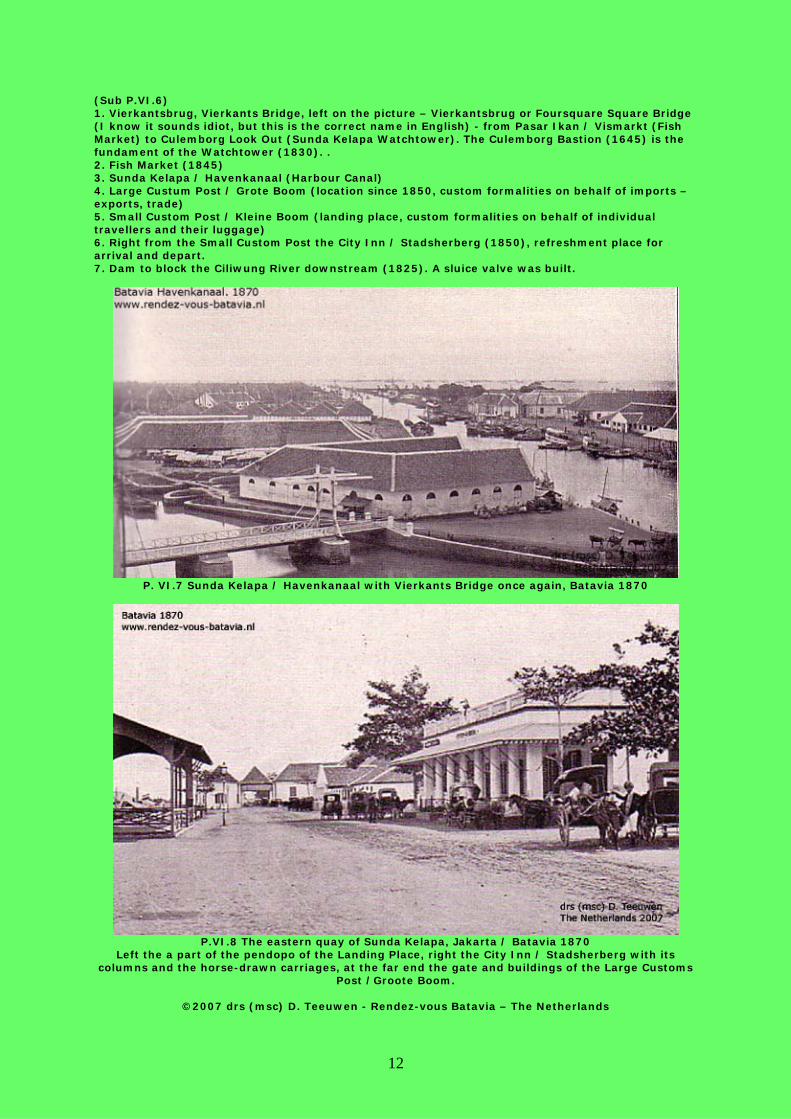
(Sub P.VI.6) 1. Vierkantsbrug, Vierkants Bridge, left on the picture – Vierkantsbrug or Foursquare Square Bridge (I know it sounds idiot, but this is the correct name in English) - from Pasar Ikan / Vismarkt (Fish Market) to Culemborg Look Out (Sunda Kelapa Watchtower). The Culemborg Bastion (1645) is the fundament of the Watchtower (1830). . 2. Fish Market (1845) 3. Sunda Kelapa / Havenkanaal (Harbour Canal) 4. Large Custum Post / Grote Boom (location since 1850, custom formalities on behalf of imports – exports, trade) 5. Small Custom Post / Kleine Boom (landing place, custom formalities on behalf of individual travellers and their luggage) 6. Right from the Small Custom Post the City Inn / Stadsherberg (1850), refreshment place for arrival and depart. 7. Dam to block the Ciliwung River downstream (1825). A sluice valve was built.
P. VI.7 Sunda Kelapa / Havenkanaal with Vierkants Bridge once again, Batavia 1870
P.VI.8 The eastern quay of Sunda Kelapa, Jakarta / Batavia 1870
Left the a part of the pendopo of the Landing Place, right the City Inn / Stadsherberg with its columns and the horse-drawn carriages, at the far end the gate and buildings of the Large Customs
Post /Groote Boom.
©2007 drs (msc) D. Teeuwen - Rendez-vous Batavia – The Netherlands

13
P.VI.9 The City Inn faded away, a tasteless substitute for Coca Cola lovers: all there is now.
P.VI.10 Sunda Kelapa more closely, Jakarta 2006
Below in the middle the brick fastening of the Vierkants Bridge.
©2007 drs (msc) D. Teeuwen - Rendez-vous Batavia – The Netherlands

14
P.VI.11 Sunda Kelapa to the north, Jakarta / Batavia 1912
P.VI.12 Sunda Kelapa to the north, Jakarta / Batavia 1895
This sluice was built on the spot of the dam, on P.VI.9. This photo was taken from the most northern bridge over Ciliwung River (Kali Besar), see P.I.1 nr. 5.
P.VI.13 Sunda Kelapa to the north, Jakarta / Batavia 2002
©2007 drs (msc) D. Teeuwen - Rendez-vous Batavia – The Netherlands

15
P.VI.14 The Castle Bridge at the southern end of Sunda Kelapa, Jakarta / Batavia 1910
This drawing bridge connected the the quay of the Harbour Canal and the location of the former V.O.C.-Castle. Before the bridge there is the end of the quay of Sunda Kelapa / Havenkanaalweg. At
the other side of the bridge Jl. Tongkoi / Kasteelweg starts. Jl. Tongkoi becomes Jl. Cengkeh / Prinsenstraat after a couple of kilometres. On P.1 there is still a drawing bridge (hardly) visible near
number 4. Maybe this drawing bridge replaced the one on this picture, but I am not sure. But finally, regrettably, around 1960, a new bridge was built on this place.
P.VI.15 Jakarta’s hope and future, Sunda Kelapa, Jakarta 1998
©2007 drs (msc) D. Teeuwen - Rendez-vous Batavia – The Netherlands

16
VII. Watch Tower “De Uitkijk” (1830) on V.O.C.-bastion Culemborg, V.O.C.-warehouses and entrepôts (west side warehouses, now Museum Behari)
(1650), V.O.C.-bastion Zeeburg (1650), the moat of Old Batavia, V.O.C.-bastion Groningen
Numbers 6,7,8,9,10 on P.I.1, page 2
P.VII.1 Sunda Kelapa to the north, left V.O.C.-warehouses and entrepôts (west side warehouses,
now Museum Behari) from 1650.
P.VII.2 V.O.C.-wharehouses, west, from the east, Jakarta / Batavia in 1920
Vierkantsbridge at the left on picture P.VI.6 as well as on P.VI.7 was demolished in 1910. The Vierkantsbridge connected former Pasar Ikan / Vismarkt (Fish Market) to Bastion Culemborg and its Look Out (Sunda Kelapa Watchtower, or Watchtower Kijkuit). The Culemborg Bastion (1650) is the fundament of the Watchtower (1830).
©2007 drs (msc) D. Teeuwen - Rendez-vous Batavia – The Netherlands

17
P.VII.3 Once again the Vierkantsbridge, Jakarta / Batavia 1890 and on P.VII.4 below, Sunda
Kelapa, Jakarta / Batavia 1885, Left the Vierkantsbridge.
©2007 drs (msc) D. Teeuwen - Rendez-vous Batavia – The Netherlands
P.VII.4 (left) The
V.O.C. city wall
from 1650 in
1996
P.VII.5 (right)
The V.O.C.
city wall in 1935
18
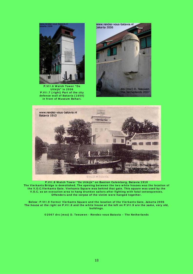
P.VII.8 Watch Tower “De Uitkijk” on Bastion Culemborg, Batavia 1910
The Vierkants Bridge is demolished. The opening between the two white houses was the location of the V.O.C.Vierkants Gate. Vierkants Square was behind that gate. This square was used by the
V.O.C. as an execution area to hang drunken sailors after fighting with fatal consequences. Offenders and the corpse of the victim were hanged together.
Below: P.VII.9 Former Vierkants Square and the location of the Vierkants Gate, Jakarta 2006
The house at the right on P.VII.8 and the white house at the left on P.VII.9 are the same, very old, buildings.
©2007 drs (msc) D. Teeuwen - Rendez-vous Batavia – The Netherlands
P.VII.6 Watch Tower “De
Uitkijk” in 2006 P.VII.7 (right) Part of the city defence wall of Batavia (1650)
in front of Museum Behari.

19
P.VII.9 (Page 18)
P.VII.10 See P.VII.8, Jakarta 1998
©2007 drs (msc) D. Teeuwen - Rendez-vous Batavia – The Netherlands

20
P.VII.11 and P.VII.12 Old houses at the foot of Watch Tower “De Uitkijk”, Jakarta 2006

21
P.VII.13 V.O.C.-wharehouses (west), Batavia 1930
Invisible at the far end of, what is now, Museum Behari, Bastion Zeeburg.
P.VII.14 V.O.C.-wharehouses (west) northern part with Bastion Zeeburg, Batavia 1915
Invisible: Bastion Groningen, built around 1650 in the same style, at the right.
P.VII.15 (below)The last remains of the V.O.C.-warehouses at the eastern side of the former castle, Jakarta 2006
©2007 drs (msc) D. Teeuwen - Rendez-vous Batavia – The Netherlands

22
P.VII.15^ P.VII.16 Once again, I cannot give up, Batavia 1915
VIII. Account for pictures P.IV.2: dr F.W. Stapel, Geschiedenis van Nederlandsch-Indië dl 3, Amsterdam 1941
P.VII.2,3.14 dr J. de Haan: Oud Batavia, platenalbum, Batavia 1923 P.VII.4 Brochure Museum Behari, Jakarta 1996
Private collection postcards and maps Dirk Teeuwen, photographs taken by Dirk Teeuwen
End of the article: ©2007 drs (msc) D. Teeuwen - Rendez-vous Batavia – The Netherland

23